
Abstract
Problem, research strategy, and findings
The width of street rights-of-way is normally determined by traffic engineering and urban design conventions, without considering the immense value of the underlying land. In this article, I develop an economic framework that can inform decisions on street width, and I use tax parcel data to quantify the widths, land areas, and land value of streets in 20 of the largest counties in the United States. Residential street rights-of-way in the urbanized portion of these counties average 55 ft wide, far greater than the functional minimum of 16 ft required for access. The land value of residential streets totals $959 billion in the urbanized portion of the 20-county sample. In most counties, subdivision regulations are binding. That is, few developers choose to build streets that are wider than code requirements, implying that softening requirements would mean more land devoted to housing and less to streets. Although I highlight the potential for narrower street rights-of-way, I did not consider detailed design issues. Nor did I analyze how any windfall from reduced land requirements would be divided among landowners, developers, and house purchasers.
Takeaway for practice
Particularly in places with high land values and housing costs, reallocating street rights-of-way to housing would increase economic efficiency. In the most expensive county in the data set—Santa Clara (CA)—narrowing the right-of-way to 16 ft would save more than $100,000 per housing unit through reduced land consumption. Where streets have little or no function for through traffic, the costs and benefits accrue almost exclusively to neighborhood residents. Thus, planners could reduce or even eliminate street width requirements in subdivision ordinances, leaving developers to make the trade-off between land for streets and land for housing.
Urban planners and designers are rethinking how to use a city’s most valuable asset, street rights-of-way. Parklets, protected bicycle lanes, and bioswales to capture stormwater runoff are just some of the innovations that have captured the interest of cities across the United States. Design and best practice guides increasingly recognize the value of streets as public spaces with functions that extend beyond the movement and storage of motor vehicles.
The planning and design discourse, however, has largely focused on how to divide up a given quantity of land between competing uses; that is, how to allocate a fixed street right-of-way. Less attention, either normatively or empirically, has been paid to how much urban land is or should be devoted to streets. The tradeoff between land for streets and land for other urban uses—parks, housing, commerce, public facilities, and so on—is implicit or ignored altogether.
Planners have long sought to quantify the amount of land devoted to transportation infrastructure (Meyer & Gómez-Ibáñez, Citation1981) and provide guidance on roadway dimensions (Kulash, Citation2001). Most recently, attention has focused on the land consumption and cost of parking (Chester et al., Citation2015; Gabbe et al., Citation2021; Guo & Schloeter, Citation2013; Shoup, Citation2005). In this study, in contrast, I focus on the street rights-of-way that furnish the long-term skeleton of a city, rather than off-street parking that can more easily convert to alternative land uses. I go beyond quantifying the amount of land devoted to streets and estimate the value of that land and its opportunity cost, which in turn informs the normative question of how wide streets should be. I consider the question of street width from an economic standpoint, rather than the engineering and urban design perspectives that dominate the street design literature.
The amount of land devoted to streets depends on their density, which is affected by network structure and block length. In this study, I focus exclusively on width. Although the economic tradeoffs between land for streets and land for other uses can also inform decisions on street network structure and block length, there are numerous considerations such as connectivity, design, and traffic flow, which are beyond the scope of this study but are well discussed elsewhere (e.g., Aurbach, Citation2020; Marshall, Citation2005; Poulton, Citation1982; Southworth & Ben-Joseph, Citation2003).
After a brief review of the existing literature, I develop a normative framework for decisions on street width. I then provide empirical estimates of the land area and value of streets in 20 of the largest U.S. counties and how these have evolved over the past 2 centuries. I examine whether subdivision regulations are a binding constraint on developers and investigate the potential savings from reducing street width. I conclude that planners should relax street width standards in subdivision regulations, especially where land costs are high, or even eliminate standards and leave it to developers to balance the allocation of land between streets and other uses.
In this study I use street to refer to the entire right-of-way, including sidewalks, landscaping, and the roadway. I use roadway to refer to the portion of the street between the curbs. I focus on residential streets in urbanized areas where through traffic is nonexistent or minimal. In such a context—which typifies the vast majority of postwar urban development in the United States—almost all of the benefits of streets are captured by the neighborhood residents. On arterials and other through streets, in contrast, movement is the primary function, whether by private vehicle or other modes, and a broader set of considerations applies.
The Widths of Streets and Their Origins
Postwar estimates of the percentage of land devoted to street rights-of-way in U.S. cities yield a range of 13% to 30% of land area (Manvel, 1968, summarized in Meyer & Gómez-Ibáñez, Citation1981). Car-dependent cities may have a lesser percentage of land devoted to streets but a greater area per person (Meyer & Gómez-Ibáñez, Citation1981). However, the definition of streets and the methods are somewhat opaque; Manvel, for example, relied on self-reported data captured through a survey of city staff. More generally, some studies refer to roadway area, some to street rights-of-way area, and some to impervious surface area, whereas others include off-street parking as well. Manville and Shoup (Citation2005) documented how claims about the area of land devoted to streets are often hard to source, concluding that “serious attempts to ascertain the surface composition of U.S. cities have been rare” (p. 235).
At a global level, however, recent work has provided a consistent definition and method based on aerial imagery. In particular, the Atlas of Urban Expansion (Angel et al., Citation2016) quantified street space—defined as land that is currently used for pedestrian or vehicle travel or is clearly reserved for its future use—for 200 large cities. These rights-of-way account for 20% of city land area developed since 1990, but there is a wide range from less than 10% in Kozhikode (India) to more than one-third in Riyadh (Saudi Arabia) and Palmas (Brazil). A similar approach using a different sample of cities yielded a range from 6% in Bangui (Central African Republic) to 36% in Manhattan (NY; UN Habitat, Citation2013).
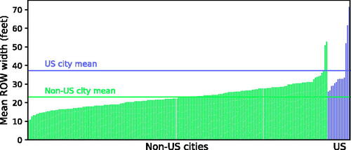
In the Atlas of Urban Expansion data set, recent average street width ranged from 10.5 ft in Ibadan (Nigeria) to 71.5 ft in Cleveland (OH; ). Although narrow streets are more prevalent in low-income countries, plenty are found in high-income cities in Europe and East Asia: the average street width is less than 20 ft in post-1990 development in Paris (France), Seoul (South Korea), Osaka (Japan), and Milan (Italy; Angel et al., Citation2016).
In both the Atlas (Angel et al., Citation2016) and UN Habitat (Citation2013) studies, cities in the United States were in the upper end of the range in terms of land area devoted to streets. On a per person basis, U.S. cities are likely to be even more out of step with global norms, given their low population densities.
Figure 1. Mean right-of-way widths in select cities, 1990–2015. Each bar represents one of the 200 cities in the data set. The U.S. cities (in increasing order of width) are Springfield (MA), Philadelphia (PA), Minneapolis (MN), New York (NY), Toledo (OH), Raleigh (NC), Gainesville (FL), Chicago (IL), Houston (TX), Portland (OR), Modesto (CA), Los Angeles (CA), Killeen (TX), and Cleveland (OH). Each city represents the built-up metropolitan area rather than administrative boundaries. Source: Data from Angel et al., Citation2016.
The historical roots of wide streets in the United States are well documented by Southworth and Ben-Joseph (Citation2003). Federal standards emerged in the 1930s, specifying a minimum 50-ft (15.2 m) right-of-way for residential streets to qualify for Federal Housing Administration mortgage guarantees. Subsequent local subdivision regulations typically followed the federal lead. All but five of the 216 jurisdictions investigated by Lautner (Citation1941) specified a minimum width of 40, 50, 60, or 66 ft, with the 50-ft standard accounting for more than half the cases. By the 1990s, one survey of municipal public works and traffic engineering officials found that cities typically required a width of between 50 and 60 ft, mirroring specifications recommended by the Institute of Transportation Engineers in 1967 (Ben-Joseph, Citation1995a).
Developers welcomed early subdivision regulations, because standards for streets, utilities, etc., were thought to enhance marketability and also restrict competition (Weiss, Citation1987). Urban designers, though, often saw these standards as excessive for local streets while calling for wider main thoroughfares. As early as 1910, Frederick Law Olmsted Jr. complained of the “quite needless and undesirable rigidity upon certain fixed standards of width” by street planners, “which make the cost needlessly high for purely local streets” (Olmsted, Citation1910, p. 68). Meanwhile, a classic text by Robinson (Citation1911, p. 3), The Width and Arrangement of Streets, called for “less standardization, for wider main streets, and for the narrowing of those with little traffic value.”
Not until the rise of the New Urbanist movement in the 1990s, however, was there a widespread move to challenge subdivision standards and reduce street widths. Best practice guides (e.g., Kulash, Citation2001; Neighborhood Streets Project Stakeholders, Citation2000) called for fewer and narrower traffic lanes to improve safety, esthetics, and livability. Narrow streets ordinances that reduced the rights-of-way from, say, 60 ft to 48 ft were adopted in several communities (Southworth & Ben-Joseph, Citation2003). Moreover, new traffic engineering and street guidance began to provide considerable flexibility, often recommending widths for lanes but not the overall right-of-way and emphasizing the importance of local context. For example, the American Association of State Highway and Transportation Officials (AASHTO, Citation2019) recommends a roadway width (excluding landscaping and sidewalks) of 18 to 38 ft for urban, low-volume residential streets. Such a wide range gives considerable flexibility to planners and designers.
These recent moves toward narrower streets and more flexible design standards leave two major questions unresolved. First, to what extent have they been reflected in the dimensions of streets that are actually built? Second, how can planners conceptualize and determine optimal street widths? I turn to an empirical analysis later in this article but first develop a normative framework to consider how wide a street should be.
Conceptualizing the Value of Streets
From an economic perspective, the amount of space devoted to street rights-of-way should be related to the value of the underlying land. The more expensive the land, the greater the opportunity cost of using that land for streets—not just for motor vehicles but for bicycles and pedestrians as well—rather than housing or parks. Yet neither early subdivision standards nor the more recent calls for narrower streets have seen street rights-of-way as an economic tradeoff. Land value is seen as immaterial (i.e., ignored) in both conventional (e.g., AASHTO, Citation2018) and progressive (e.g., National Association of City Transportation Officials [NACTO], Citation2013) street design manuals. Rather, ever since street design emerged as the prerogative of engineers rather than economists in the early 20th century (Norton, Citation2008), the dimensions of streets have remained the domain of traffic engineers and urban designers.
As with any other good, the value of urban land can be conceptualized as marginal willingness to pay. For most lots, marginal willingness to pay is readily quantified as the sale or rental price per square foot, which takes into account zoning constraints as well as local amenities. Empirically, complications ensue from apportioning the price of a property into its two components—land and the structures on the lot (Özdilek, Citation2016)—but, in principle, marginal willingness to pay for land is revealed by the price of a vacant, unimproved lot.
Under this framework, the social value of adjacent pieces of urban land, whether private property or street rights-of-way, should be equal at the margin. If the marginal value of the street right-of-way is less than the marginal value of the adjacent land, it implies that too much land is devoted to streets and too little to housing, retail, and other urban uses. Indeed, a series of theoretical papers in urban economics formalized this conclusion (Arnott & MacKinnon, Citation1978; Kanemoto, Citation1976, Citation1977; Muth, Citation1975; Pines & Sadka, Citation1985; Solow, Citation1973).Footnote1
Street rights-of-way, however, are not bought and sold in the marketplace, meaning that no data are available that would reveal willingness to pay. Moreover, many functions of streets are a public good and thus are not fully captured in market transactions. Therefore, in the subsequent paragraphs I decompose the value into the core functions of streets identified by urban designers and other scholars (Jacobs, Citation1995; Norton, Citation2008)—primarily access, movement, and storage—and consider each in turn.
Access Value
Without access, a lot has essentially no value. In a few cases, access might be provided via an easement through a neighbor’s property, but in urban areas access is invariably via the street. A first approximation of the access value of a street, therefore, is the value of the abutting parcels, because a property owner would be willing to pay up to the value of the parcel to access it.
The width of the right-of-way required for access alone, however, is minimal. Some parcels might make do with pedestrian-only access, as in Anna Madrigal’s stairway house in the novel Tales of the City, modeled after Macondray Lane in San Francisco (CA; De Anda, Citation2014). Even assuming vehicular access is desirable, the street need be little wider than a garbage or moving truck, and the right-of-way can be shared without curbs, Dutch woonerf style (Ben-Joseph, Citation1995b), between pedestrians and motor vehicles. Sixteen feet (about 5 m2Footnote )—the minimum alley width recommended by AASHTO (Citation2018)—is a reasonable minimum width to enable access on any street beyond which there is little or no additional access benefit. Utilities can easily be accommodated in a 16-ft right-of-way as well.
Emergency access might warrant a wider street than access for humans and deliveries alone, and the Uniform Fire Code recommends a minimum clear path of 20 ft (Snyder et al., Citation2013). However, street width is just one of many factors that affect fire response times, with street connectivity being just as important (KC & Corcoran, Citation2017). Moreover, fire departments often adapt their equipment to match the prevailing local geography (Snyder et al., Citation2013).
Movement Value
The contemporary traffic engineering and economics literatures see movement as a street’s main function. The quantification of movement value in the form of time savings to road users lies at the heart of much of the transportation economics literature (Small & Verhoef, Citation2007), and some urban economists analyze the marginal value of streets solely in terms of congestion reduction (e.g., Muth, Citation1975).
On low-volume residential streets, however, movement can be accommodated using the same 16-ft right-of-way that is required for access in the form of a single bidirectional lane. Widening beyond 16 ft may increase movement value for motor vehicles, through reducing delays as vehicles coming from opposing directions try to pass. Normally, however, a “yield street”—a single bidirectional lane with passing places—suffices for through movement. A second lane might save a few dozen drivers a day from slowing down or backing up when meeting an oncoming vehicle, but the inconvenience is “remarkably low in areas where single-family units prevail” (AASHTO, Citation2018, p. 5-16). Moreover, it is questionable whether these time savings should be valued at all given that many cities seek to actively slow down vehicles (i.e., traffic calming) to create more livable and safer streets. The evaluation or cost–benefit analysis of traffic calming schemes rarely if ever considers lost time as drivers slow for speed humps or chicanes; on the contrary, reducing speeds is an explicit goal of traffic calming, albeit one that may vex vocal residents (Ewing & Brown, Citation2009).
What about movement for other road users, particularly pedestrians and cyclists? Here, value from additional width pertains more to safety than to speed. On a woonerf (shared street), no additional right-of-way is required beyond the 16-ft access width. A shared surface would restrict vehicles to walking pace and enable safe and comfortable travel for pedestrians (Ben-Joseph, Citation1995b; NACTO, 2013). On conventional streets with higher motor vehicle volumes or speeds, sidewalks provide an important safety benefit, if one that is hard to quantify. Adding sidewalks to both sides of the street would increase the minimum width from 16 ft to 26–32 ft. In contrast, bicycle lanes are rarely necessary on residential streets due to low volumes and speeds.
Storage Value
The desire to provide on-street parking was a key reason behind the gradual increase in recommended street widths in engineering and design manuals over the 20th century (Guo & Schloeter, Citation2013). The best guide to the storage value of a residential street is given by the price of its closest equivalent, an off-street parking space (although off-street parking provides additional benefits such as security and weather protection). In most places in the United States, ample on- and off- street parking means that the market clearing price is effectively zero. Not surprising, few if any residents bother to offer to lease their surplus off-street spaces to a neighbor. Moreover, on-street occupancy is low in most U.S. neighborhoods, providing further evidence that the marginal value of storage space is effectively zero. This is not to say that on-street parking is not valued by residents but rather that so much exists that willingness to pay for the marginal space is zero.
One exception is in dense, urban neighborhoods where overnight curbside occupancy approaches 100%. Even here, however, on-street parking may be a suboptimal use of land.Footnote3 For example, many San Francisco residents are converting garages into accessory dwelling units, which implies that the marginal value of floor area under housing is greater than that under off-street parking. If this logic applies to off-street parking, it is likely to apply to on-street parking too.Footnote4 A related exception would be if off-street parking provision were to be substantially reduced. The less off-street parking, the higher the marginal value of on-street parking, pointing to the need to consider street widths in tandem with the characteristics of development on that street.
Other Values
Access, movement, and storage likely account for most of a street’s value. However, these categories are not exhaustive; other benefits of streets include social and play space, stormwater drainage in vegetated strips, space for street trees and waste collection, a corridor for utilities, and the provision of light and air to adjacent buildings. These other values are often important but are highly context dependent or do not require additional right-of-way. Social and play space, for example, can occur in the same part of the street used for access, in the case of a woonerf or even a quiet cul-de-sac. Street trees and garbage or recycling containers might be interspersed with parking spaces or placed in front setbacks. Similarly, the value of light and air may be high where buildings are tall and are not set back from the street but negligible on streets where this function is already provided by front yards.
Combining the Component Values
The preceding discussion, summarized in , implies that the marginal value of a street is decreasing in its width. The first 16 ft has the highest value. At such a width, a shared street can provide access and movement for pedestrians, cyclists, and motor vehicles without the need for dedicated sidewalks and also provide space for socializing and play. Indeed, the average width of streets in recently developed parts of Tokyo (Japan) is 16.4 ft (Angel et al., Citation2016), and such narrow streets have neither sidewalks nor on-street parking, as shown in . Similar widths are typical of pre-industrial European centers as well. In the Hampstead Garden Suburb of London (UK), for example, they are 20 ft wide (Southworth & Ben-Joseph, Citation2003).
Figure 2. Shibuya City, Tokyo (Japan). The right-of-way is approximately 13 to 16 ft wide and provides a shared space for pedestrians and motor vehicles. Photo credit: Felix Vazquez.
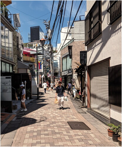
Table 1 Typology of the value of streets.
How Wide Should Streets Be?
Under what circumstances should a street be wider than 16 ft? Based on the discussion above, sidewalks may be warranted where a shared-street design is infeasible, taking the width to 26 to 32 ft. Movement for cars may warrant an additional lane where traffic volumes are high and/or land is inexpensive and where traffic calming to slow vehicles is not desired. The second lane could be accommodated in a 22-ft-wide roadway, giving a right-of-way (with sidewalks) of 32 to 36 ft.
What about on-street parking? As noted above, in suburban areas with ample off-street parking, low occupancy indicates that the marginal value of a space is zero. Moreover, providing a continuous parking lane is an inefficient use of space where driveways and fire hydrants preclude parking along the entire length. Therefore, an irregular street that widens out at intervals to provide parking bays can be a more effective use of space. The same is true of space for trees and other landscaping, which can be accommodated at intervals and do not require a continuous strip. Access for utility maintenance and repair might require further analysis, but on low-volume residential streets the street could simply be closed to motor vehicles for infrequent repair work. The finding in that many countries have streets that are 16 ft wide or less suggests that there is ample scope to look to international examples for how to creatively accommodate the functions of streets in a narrow right-of-way.
For a street with little to no through traffic, almost all of the value of its amenities accrues to the residents (). This insight has two implications. First, the relationship between property prices and street width could in principle provide empirical insight into whether streets are under- or overprovided. Most studies that sought to uncover the determinants of property prices (so-called hedonic pricing models) did not even include street width as a variable, suggesting the authors saw it as an unimportant factor. Walkability, traffic noise, and street connectivity are commonly included in hedonic models (e.g., Bartholomew & Ewing, Citation2011; Matthews & Turnbull, Citation2007), but street width is notable by its absence. Among the exceptions, wider streets in El Paso (TX) are associated with lower property values (Fullerton & Villalobos, Citation2011), presumably because of their negative esthetics and traffic speeds. In Japan, where streets are much narrower, increasing their width does lead to an increase in the value of the abutting properties, possibly because of easier emergency access (Gao & Asami, Citation2007).
Second, because the benefits of a street accrue to its residents and property owners, developers are likely to be in the best position to optimize the allocation of land between streets and housing. Indeed, why should subdivision codes specify the width of residential streets at all? Developers might prefer to include some of the functions of streets such as light and air, parking, and landscaping within front setbacks or dispense with them altogether in places where land is expensive. I return to this question in the conclusion.
Estimating Street Dimensions and Land Value
I quantified the dimensions of residential streets using a novel approach based on GIS parcel databases. In essence, the voids between parcels represent street rights-of-way, and I calculated their widths and areas. Each void was assigned to a street based on the OpenStreetMap network (Citation2020). The year built was assigned using the data set in Leyk et al. (Citation2020), assuming that streets were built contemporaneously with the earliest building in that 250 m2 grid cell and that street widths have not changed since construction. The core results focused on streets that are tagged in OpenStreetMap as “residential” and located in census-defined urbanized areas. The Technical Appendix provides full details of the procedure, and the data set and code are available at https://streetwidths.its.ucla.edu and https://github.com/amillb/streetwidths, respectively.
This parcel-based method differs from the typical approach that uses aerial imagery or field measurements. A parcel-based approach is more comprehensive because it can quantify the dimensions of every street, not just a sample. Moreover, the boundaries of the right-of-way are not always discernable in aerial imagery due to overhanging vegetation or low resolution, and perhaps for this reason analysts often focus on roadway rather than right-of-way width (or do not specify which they are quantifying). On the other hand, parcel data sets may only represent approximate lot boundaries. In practice, however, a validation assessment shows that estimates from the two methods are in close agreement (see the Technical Appendix).
The land value of a street is based on the Davis et al. (Citation2020) data set, which estimates standardized land values (in 2019 prices) at the census tract level for a quarter-acre lot under single-family use. I imputed values for missing tracts based on the average of adjacent or nearby tracts. The Davis et al. estimates will generally underestimate land value in high-cost urban areas where single-family residences on quarter-acre lots are not the highest and best use of land—for example, where developers would choose to subdivide into smaller parcels and/or construct multifamily housing. On the other hand, they will overestimate the value of small additions to existing parcels, as the per acre value of a front yard enlargement will normally be less than that of a new, buildable lot.
My sample consisted of 20 U.S. counties. I began with the 20 largest U.S. counties, by population, which gives a sample of 17 when restricted to counties for which GIS parcel data are freely available. To ensure geographic representation, I added the largest county in each of the nine regional census divisions, where this was not already included in the initial sample. These additional three counties are Hennepin (MN), Shelby (TN), and Middlesex (MA). Although the 20-county sample is not representative, it provides considerable variation in geography, epoch of urban development, and location within the metropolitan core. For example, the sample includes older central cities such as Chicago (IL), the inner-ring suburbs of Boston (MA), and Sun Belt and Western cities such as Phoenix (AZ) and Dallas (TX) that have grown rapidly in the late 20th century. Because data cleaning and preparation is conducted at the county level, focusing on the largest counties provides an efficient analysis mode.
How Wide Are Residential Streets?
shows the width and land area of street rights-of-way in the sample counties. The median width of a residential street in the sample is 50.2 ft; the mean width, weighted by the length of each street, is 55.2 ft. However, these summary statistics do not provide a complete picture of residential street width because of the bimodal nature of the distribution. As shows, there are spikes in the street width distribution. Remarkably, when rounded to the nearest foot and weighted by length, 41% of residential streets in the sample are exactly 50 ft or 60 ft wide.
Figure 3. Distributions of residential street width.
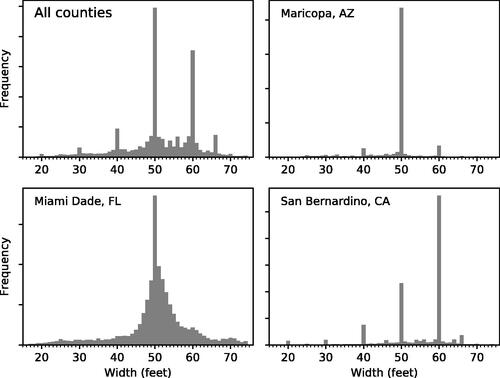
Table 2 Width and area of streets.
The modes of the distribution are accentuated at the individual county level. shows results for selected counties, with the Technical Appendix providing results for all counties in the data set. In Maricopa County (AZ), 62% of residential streets are 50 ft wide, whereas in Cook County (IL), 48% are 66 ft wide. Counties that have a smoother distribution of street width, such as Miami–Dade County (FL) in , are the exception rather than the norm. Even in Miami–Dade, however, the smoother distribution is a result of the county’s historical legacy. More recently constructed residential streets adhere to the specifications of the county’s Public Works Manual; of those constructed in 1990 or later, for example, 44% are precisely 50 ft wide. (All figures in this paragraph are weighted by street length.)
The heavily modal distributions of street width provide compelling evidence that subdivision standards and similar regulations are a binding constraint. It is unlikely that such a heavily peaked distribution would arise through individual developer decisions. Even if lane widths were standardized, it would be surprising for so many developers to make identical decisions on the provision of on-street parking and the dimensions of parking lanes, sidewalks, and vegetated buffers. Moreover, the variation between counties suggests that the national-level standards and guidance highlighted in Southworth and Ben-Joseph (Citation2003)—for example, from the Federal Housing Administration and Institute of Transportation Engineers—are not the determining factor.
A comprehensive analysis of subdivision standards is beyond the scope of this study, not least because standards often vary between cities within a county and over time. However, some examples are illustrative. The subdivision codes or street design manuals of Dallas County (Citation2017) and the City of Dallas (Citation2019) specify 50 ft as the minimum width for all residential streets. In Cook County, the City of Chicago mandates a 66-ft right-of-way to provide continuity with the existing grid, even though its historical origins are arbitrary, being based on the 66-ft length of a surveyor’s chain (City of Chicago, Citation2007). The City of San Diego (CA) Street Design Manual specifies a 50- to 60-ft width for most low-volume residential streets (Citation2017). In most cases, these standards are clearly reflected in the distributions of street widths in and Figure A-4 in the Technical Appendix.
Changes in width over time are evident in , especially an initial rise in the mid-19th century followed by a steep decline until the 1920s. Surprisingly, the rise of private car ownership since the early 20th century has not been reflected in wider residential streets, reflecting the long-standing nature of subdivision standards that date to the pre-automobile era. In the 1920s and 1930s, the street was reconceptualized from a place for pedestrians to a place for automobiles (Norton, Citation2008), and roadways were often widened at the expense of sidewalks through the postwar era. But shows that more private cars did not translate into wider rights-of-way.
Figure 4. Trends in street width.
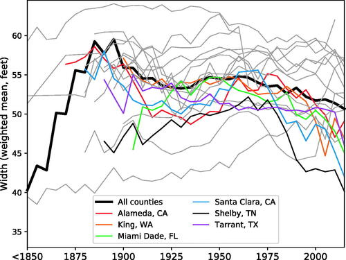
On the contrary, a small decline in street width has occurred since the 1960s, especially in the six counties highlighted in . Of these counties, Alameda and Santa Clara lie in the San Francisco Bay Area, and King, Shelby, and Tarrant are home to the cities of Seattle (WA), Memphis (TN), and Fort Worth (TX), respectively. The New Urbanist calls for narrower streets in the late 1990s and early 21st century, discussed above, may have played a role as suggested by Guo and Schloeter (Citation2013), but the decline in street width long predates the rise in the New Urbanist movement. For example, San Jose (CA), the largest city in Santa Clara County, adopted a Complete Streets policy in 2018, but its rapid decline in widths occurred much earlier (City of San Jose, Citation2018).
These findings are supported by a regression analysis, which showed a similarly rapid increase in street width in the 19th century and a post-1960 decline, even after controlling for county-specific characteristics, residential density, land value, and street length. Suggestively, present-day residential density and street length are positively correlated with street width, whereas land value is negatively correlated. The Technical Appendix provides further details.
The Land Value of Streets
shows the estimated value of land under street rights-of-way, both as a total for the urbanized area of each county (left panel) and on a per residential unit basis (right panel). The per unit figures provide a normalized measure of the value of land devoted to streets, which is particularly relevant in contextualizing the results from New York City (where streets are wide but divided among more households). In most counties, residential streets account for about half of the land value of rights-of-way. In absolute terms, the numbers are strikingly large, totaling $1.8 trillion in the counties in the data set, of which just more than half ($959 billion) is for residential streets.
Figure 5. Land value of streets.

On a per unit basis, there is considerable variation. At the low end, street land values of $7,000 to $14,000 per unit are found in the Texas counties of Bexar and Tarrant and in Shelby (TN). At the other extreme, the highest street land values are found in coastal California counties, most notably Santa Clara, where the value of land under residential streets amounts to $146,000 per unit. Even though Santa Clara County streets are relatively narrow by U.S. standards, a combination of low densities and high property prices means that the value of these streets is more than double that of any other county in the data set bar other California coastal counties.
New York City street land values are in the middle of the range, reaching $36,000 per unit in Queens County and $57,000 per unit in Kings County (which consists of the borough of Brooklyn). Even though land in these counties is expensive and streets account for a high proportion (nearly 30%) of urban land area, high densities with a prevalence of medium-rise apartments and rowhouses mean that each street is shared by many households.
Potential Savings from Narrower Streets
presents the savings in terms of land value from narrowing street rights-of-way. Of course, there are practical constraints to realizing this value, as I discuss in the conclusion, and so for now can be understood as a hypothetical exercise. Moving from left to right along the chart, the streets are gradually reduced in width. For example, at 50 ft, all streets wider than 50 ft are narrowed to 50 ft, with other streets left unchanged. Intersections and irregular portions of the right-of-way are narrowed proportionately. On the left, the curves are relatively flat, given that few streets are more than 60 ft wide. On the right, the curves converge to a linear slope, given that almost all streets are narrowed in this portion of the range.
Figure 6. Potential land value savings from narrowing residential streets.
Note: The x-axis is truncated at 16 feet, which is the approximate minimum required for access.
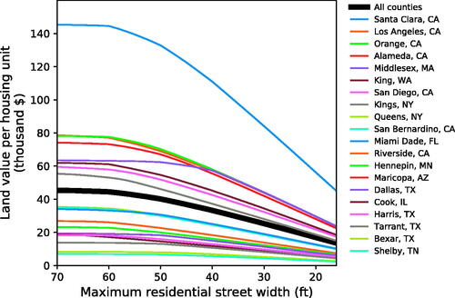
These results can be interpreted as the social savings from narrower streets or, conversely, the opportunity costs of wider streets. They show that in high-cost counties, considerable savings are achieved from relatively modest reductions in street width. In Santa Clara, narrowing residential streets from their present widths to the post-2000 average width of 46 ft saves $21,000 per residential unit. A further narrowing to the practical minimum of 16 ft saves $101,000 per unit. Depending on the level of regulation, competition, and supply and demand elasticities in local housing and land markets, these savings may be realized through lower housing costs, windfalls to landowners, and/or increased ability of local governments to exact public benefits such as parks, conservation set-asides, and impact fees from developers.Footnote5
Outside of coastal California, the potential savings may seem minimal. However, this masks the heterogeneity within counties. Most counties have high-value neighborhoods where land values overlap with the distribution in Santa Clara (see Technical Appendix Figure A-5). Thus, the county-level averages presented in and disguise places where the effect of street widths is considerable.
Conclusion
My analysis here suggests that in many U.S. cities, residential streets are too wide and too much land is devoted to the street right-of-way. Particularly in high-cost West Coast counties, housing costs are inflated, densities are constrained, and overall social welfare is reduced because too much land is devoted to streets instead of housing. U.S. streets are exceptionally wide by international comparison and from the perspective of urban economics. The causes of wide streets and the considerable heterogeneity between counties would be a valuable avenue for future research, but here I focus on the consequences.
Many analysts have recognized the problem of overly wide traffic lanes from a safety and urban design perspective and proposed repurposing the right-of-way for parklets, bicycle lanes, medians, and stormwater management (Hebbert, Citation2005; NACTO, 2013). In many respects, however, these analyses have been too conservative: They have vigorously questioned the allocation of a fixed right-of-way width but done little to challenge the overall amount of urban land that is devoted to streets. With few exceptions (Guo & Schloeter, Citation2013; Manville, Citation2017), the question of how much land should be devoted to streets has attracted little attention outside of theoretical treatments in urban economics. Street design manuals ignore the simple economic prescription that the more valuable the urban land, the narrower a street should be.
The consequences of overprovision of streets are evident today: Street space is underused and unpriced, whereas residential and commercial rents and sale prices make many metropolitan regions increasingly unaffordable. The results of my study suggest that wide streets are not a choice by developers but rather a constraint imposed by planners through subdivision standards. Residents can normally make tradeoffs and choose a smaller yard or smaller home in exchange for other amenities or a lower price, but they cannot choose a smaller street.
A shared street with neither curbs nor delineated sidewalks is likely to be the most efficient layout on the lowest-volume streets; yield streets, with a single bidirectional lane and passing places, can be used where volumes are slightly higher. Street trees provide numerous benefits such as shade. But trees do not require a continuous strip; rather, they can be accommodated through slightly widening the right-of-way at intervals or can be interspersed with parking, garbage containers, and other infrastructure. Even fire access, often the primary rationale for wider streets, can be accomplished with much narrower rights-of-way by using smaller firefighting equipment, as seen in Japan and medieval European cities.
One potential remedy for overly wide streets would be to reduce or even eliminate street width requirements in subdivision ordinances, perhaps in exchange for more flexible and holistic design guidelines. Indeed, if minimal through traffic is expected, the rationale for government regulation of right-of-way widths is tenuous because the property owners internalize all access, parking, and local movement benefits. Certainly, narrower rights-of-way would be a financial windfall for landowners, but a city might capture and direct the surplus toward other municipal priorities. Rather than requiring the owner to effectively hand over a portion of their land via the street, a city could increase inclusionary housing requirements, require some land to be protected as natural habitat, or levy impact fees for contributions to parks, specialized firefighting equipment, and other public services.
A market-driven approach is certainly imperfect: Developers will internalize the short-term benefits to the initial purchasers of housing in a new subdivision but fail to consider longer-term demands for street space and potential changes in population and economic activity. Moreover, any public backlash against narrower streets might be directed against the cities that permitted them rather than the developers that designed them. However, it is questionable whether planners have the ability to weigh these long-term considerations either. And developers are better placed to respond to the idiosyncrasies of each particular street such as topography and the relationship between on- and off-street parking provision. Equalizing the marginal value of land under housing and streets is unlikely to be achieved through standards in subdivision codes but, in principle, is the type of tradeoff that developers are well equipped to assess. Indeed, to the extent that narrow streets constrain vehicle travel, developers might still construct streets that are wider than socially optimal, given that developers and residents will not consider citywide and global externalities from transportation.
What about existing urban development where street patterns are already cemented? The first option, as called for by Manville (Citation2017) in the Los Angeles context, is to question and scale back the practice of requiring building setbacks to accommodate street widening or turn lanes. Court cases in Detroit (MI), Pittsburgh (PA), Kansas City (MO), and elsewhere have long upheld the right of cities to require a property owner to cede land to streets as a condition of redevelopment (American Society of Planning Officials, Citation1949; Randall, Citation1929), but rarely if ever does a city consider the economic impact of widenings that shrink the area of developable land. Even on narrower transportation grounds, street widenings are often questionable; in Los Angeles, they may provide no meaningful increase in traffic capacity or there is no need to increase capacity in the first place (Manville, Citation2017).
If cities consider the widening of streets as part of new development, why not allow their narrowing where the land could be put to more productive use? Cities could sell their excess right-of-way to a developer in conjunction with a new construction project or cede it in exchange for more affordable housing or other community benefits. Although such practices may lead to streets with irregular widths, this is not necessarily problematic: Varying on-street parking provision, landscaping, and even lane widths may even add visual interest and calm traffic.
Minimum parking requirements provide a useful parallel. Whereas excess parking might be easier to repurpose than excessively wider streets, in both cases planners impose arbitrary standards that consume land, increase housing costs, and favor the private automobile. After decades of requiring developers to provide a certain amount of parking—a questionable practice on economic and environmental grounds (Shoup, Citation2005)—cities such as Buffalo (NY) and San Francisco have eliminated the requirements to reduce housing costs and spur the creation of more walkable, mixed-use neighborhoods (Henderson, Citation2014; Hess, Citation2017). Perhaps the housing crisis in parts of the United States will provide the catalyst to reform an equally damaging practice—minimum street requirements.
RESEARCH SUPPORT
This study was made possible through funding received by the University of California Institute of Transportation Studies Statewide Transportation Research Program, funded by the Road Repair and Accountability Act of 2017 (SB 1). The author would like to thank the State of California for its support of university-based research, and especially for the funding provided in support of this project.
Technical Appendix
Download PDF (1.5 MB)Acknowledgments
I am grateful to Garima Desai for invaluable research assistance and to Eric Dasmalchi for support with web development and visualizations. The article was strengthened by comments from C. J. Gabbe and seminar participants at the Institute for Social Transformation at UC Santa Cruz, as well as the editor and three anonymous reviewers.
SUPPLEMENTAL MATERIAL
Supplemental data for this article can be found on the publisher’s website.
Additional information
Notes on contributors
Adam Millard-Ball
ADAM MILLARD-BALL ([email protected]) is an associate professor of urban planning at the University of California, Los Angeles.
Notes
1 This literature typically uses analytic or numerical models to show the optimum allocation of land between housing and streets in an idealized monocentric city based on demand functions for residential space and the relationship between travel costs, residential density, and road space. The models show how optimum street width increases closer to the city center (due to higher traffic volumes). Other works analyze how congestion pricing affects the optimum allocation (Pines & Sadka, Citation1985; Solow, Citation1973). However, these models only consider streets in terms of their movement value for motor vehicles.
2 For conformance with U.S. traffic engineering guidance and local ordinances, I use feet rather than meters in this study.
3 In San Francisco’s Mission District, a search of online bulletin boards in November 2019 revealed off-street parking prices of $300 per month, equivalent to a capitalized value of about $20 million per acre. This assumes an 8 ft × 20 ft space, a 5% discount rate, and an infinite time horizon. In the same neighborhood, the unimproved land value for housing is about $26 million per acre (Davis et al., Citation2020). As discussed in the Technical Appendix, the Davis et al. (Citation2020) methodology is designed for single-family homes and may underestimate the value of land zoned for denser development. Indeed, one vacant lot in the neighborhood (1120 Valencia Street) sold in 2018 for $36 million per acre.
4 The value of the two types of parking space is not identical, meaning that the comparison is only approximate. Off-street parking can be reserved and is more secure against crime and the weather, but on-street parking can have a higher occupancy rate and may be more space efficient.
5 See, for example, Ihlanfeldt (Citation2007) for a discussion of how land use regulations affect land and house prices. The ability of landowners to capture the surplus will depend on local supply and demand elasticities but also on the relative size of the jurisdiction in the regional housing market. Requirements for wide streets are effectively a development tax, and so the literature on the incidence of impact fees also provides insights (e.g., Ihlanfeldt & Shaughnessy, Citation2004). The timing of land release (Murray, Citation2020) and the extent to which an increase in supply reduces housing prices (Been et al., Citation2019) will also affect the economic outcomes.
REFERENCES
- American Association of State Highway and Transportation Officials (AASHTO). (2018). A policy on geometric design of highways and streets (7th ed.). American Association of State Highway and Transportation Officials.
- American Association of State Highway and Transportation Officials (AASHTO). (2019). Guidelines for geometric design of low-volume roads (2nd ed.). American Association of State Highway and Transportation Officials.
- American Society of Planning Officials. (1949). Building lines, mapped streets, set backs, front yards. Information Report 1. American Society of Planning Officials.
- Angel, S., Lamson-Hall, P., Madrid, M., Blei, A. M., Parent, J., Galarza Sánchez, N., & Thom, K. (2016). Atlas of urban expansion (2016 ed., Volume 2). New York University Urban Expansion Program and Lincoln Institute of Land Policy.
- Arnott, R. J., & MacKinnon, J. G. (1978). Market and shadow land rents with congestion. The American Economic Review, 68(4), 588–600. https://www.jstor.org/stable/1808928
- Aurbach, L. (2020). A history of street networks: From grids to sprawl and beyond. Pedshed Press.
- Bartholomew, K., & Ewing, R. (2011). Hedonic price effects of pedestrian- and transit-oriented development. Journal of Planning Literature, 26(1), 18–34. https://doi.org/https://doi.org/10.1177/0885412210386540
- Been, V., Ellen, I. G., & O’Regan, K. (2019). Supply skepticism: Housing supply and affordability. Housing Policy Debate, 29(1), 25–40. https://doi.org/https://doi.org/10.1080/10511482.2018.1476899
- Ben-Joseph, E. (1995a). Changing the residential street scene: Adapting the shared street (woonerf) concept to the suburban environment. Journal of the American Planning Association, 61(4), 504–515. https://doi.org/https://doi.org/10.1080/01944369508975661
- Ben-Joseph, E. (1995b). Residential street standards & neighborhood traffic control: A survey of cities’ practices and public officials’ attitudes. Institute of Urban and Regional Planning. http://web.mit.edu/ebj/www/Official%20final.pdf
- Chester, M., Fraser, A., Matute, J., Flower, C., & Pendyala, R. (2015). Parking infrastructure: A constraint on or opportunity for urban redevelopment? A study of Los Angeles County parking supply and growth. Journal of the American Planning Association, 81(4), 268–286. https://doi.org/https://doi.org/10.1080/01944363.2015.1092879
- City of Chicago. (2007). Street and site plan design standards. Chicago Department of Transportation. https://www.chicago.gov/content/dam/city/depts/cdot/StreetandSitePlanDesignStandards407.pdf
- City of Dallas. (2019). Street design manual. https://dallascityhall.com/departments/public-works/Pages/ConstructionStandards.aspx
- City of San Diego. (2017). Street design manual. https://www.sandiego.gov/planning/programs/transportation/library/stdesign
- City of San Jose. (2018). Complete streets design. Municipal code chapter 13.05. https://library.municode.com/ca/san_jose/codes/code_of_ordinances?nodeId=TIT13STSIPUPL
- Dallas County. (2017). Subdivision regulations. https://www.dallascounty.org/departments/duas/subdivisions-and-platting.php
- Davis, M., Larson, W., Oliner, S., & Shui, J. (2020). The price of residential land for counties, zip codes, and census tracts in the United States. Working Paper 19-01. Federal Housing Finance Agency. https://www.fhfa.gov/PolicyProgramsResearch/Research/Pages/wp1901.aspx
- De Anda, J. (2014, January 30). Tourism for locals: Macondray Lane paves the path for tales of the city. SF Weekly. https://archives.sfweekly.com/exhibitionist/2014/01/30/tourism-for-locals-macondray-lane-paves-the-path-for-tales-of-the-city
- Ewing, R. H., & Brown, S. J. (2009). U.S. traffic calming manual. American Planning Association, ASCE Press.
- Fullerton, T. M., & Villalobos, E. (2011). Street widths, international ports of entry and border region housing values. Journal of Economic Issues, 45(2), 493–510. https://doi.org/https://doi.org/10.2753/JEI0021-3624450227
- Gabbe, C. J., Manville, M., & Osman, T. (2021). The opportunity cost of parking requirements: Would Silicon Valley be richer if its parking requirements were lower? Journal of Transport and Land Use, 14(1), 277–301. https://doi.org/https://doi.org/10.5198/jtlu.2021.1758
- Gao, X., & Asami, Y. (2007). Effect of urban landscapes on land prices in two Japanese cities. Landscape and Urban Planning, 81(1–2), 155–166. https://doi.org/https://doi.org/10.1016/j.landurbplan.2006.11.007
- Guo, Z., & Schloeter, L. (2013). Street standards as parking policy: Rethinking the provision of residential street parking in American suburbs. Journal of Planning Education and Research, 33(4), 456–470. https://doi.org/https://doi.org/10.1177/0739456X13504299
- Hebbert, M. (2005). Engineering, urbanism and the struggle for street design. Journal of Urban Design, 10(1), 39–59. https://doi.org/https://doi.org/10.1080/13574800500062361
- Henderson, J. (2014). Street fight: The politics of mobility in San Francisco. University of Massachusetts Press.
- Hess, D. B. (2017). Repealing minimum parking requirements in Buffalo: New directions for land use and development. Journal of Urbanism: International Research on Placemaking and Urban Sustainability, 10(4), 442–426. https://doi.org/https://doi.org/10.1080/17549175.2017.1310743
- Ihlanfeldt, K. R. (2007). The effect of land use regulation on housing and land prices. Journal of Urban Economics, 61(3), 420–435. https://doi.org/https://doi.org/10.1016/j.jue.2006.09.003
- Ihlanfeldt, K. R., & Shaughnessy, T. M. (2004). An empirical investigation of the effects of impact fees on housing and land markets. Regional Science and Urban Economics, 34(6), 639–661. https://doi.org/https://doi.org/10.1016/j.regsciurbeco.2003.11.002
- Jacobs, A. B. (1995). Great streets. MIT Press.
- Kanemoto, Y. (1976). Optimum, market and second-best land use patterns in a von Thünen city with congestion. Regional Science and Urban Economics, 6(1), 23–32. https://doi.org/https://doi.org/10.1016/0166-0462(76)90010-7
- Kanemoto, Y. (1977). Cost-benefit analysis and the second best land use for transportation. Journal of Urban Economics, 4(4), 483–503. https://doi.org/https://doi.org/10.1016/0094-1190(77)90008-0
- KC, K., & Corcoran, J. (2017). Modelling residential fire incident response times: A spatial analytic approach. Applied Geography, 84, 64–74. https://doi.org/https://doi.org/10.1016/j.apgeog.2017.03.004
- Kulash, W. M. (2001). Residential streets (3rd ed.). Urban Land Institute.
- Lautner, H. W. (1941). Subdivision regulations: An analysis of land subdivision control practices. Public Administration Service.
- Leyk, S., Uhl, J. H., Connor, D. S., Braswell, A. E., Mietkiewicz, N., Balch, J. K., & Gutmann, M. (2020). Two centuries of settlement and urban development in the United States. Science Advances, 6(23), Article eaba2937. https://doi.org/https://doi.org/10.1126/sciadv.aba2937
- Manville, M. (2017). Automatic street widening: Evidence from a highway dedication law. Journal of Transport and Land Use, 10(1), 375–393. https://doi.org/https://doi.org/10.5198/jtlu.2016.834
- Manville, M., & Shoup, D. (2005). Parking, people, and cities. Journal of Urban Planning and Development, 131(4), 233–245. https://doi.org/https://doi.org/10.1061/(ASCE)0733-9488(2005)131:4(233)
- Marshall, S. (2005). Streets and patterns. Spon Press.
- Matthews, J. W., & Turnbull, G. K. (2007). Neighborhood street layout and property value: The interaction of accessibility and land use mix. The Journal of Real Estate Finance and Economics, 35(2), 111–141. https://doi.org/https://doi.org/10.1007/s11146-007-9035-9
- Meyer, J. R., & Gómez-Ibáñez, J. A. (1981). Autos, transit, and cities. Harvard University Press.
- Murray, C. K. (2020). Time is money: How landbanking constrains housing supply. Journal of Housing Economics, 49, 101708. https://doi.org/https://doi.org/10.1016/j.jhe.2020.101708
- Muth, R. F. (1975). Numerical solution of urban residential land-use models. Journal of Urban Economics, 2(4), 307–332. https://doi.org/https://doi.org/10.1016/0094-1190(75)90031-5
- National Association of City Transportation Officials (NACTO). (2013). Urban street design guide. Island Press/National Association of City Transportation Officials. http://nacto.org/publication/urban-street-design-guide/
- Neighborhood Streets Project Stakeholders. (2000). Neighborhood street design guidelines: An Oregon guide for reducing street widths. https://www.oregon.gov/lcd/Publications/NeighborhoodStreetDesign_2000.pdf
- Norton, P. D. (2008). Fighting traffic: The dawn of the motor age in the American city. MIT Press.
- Olmsted, F. L. (1910). The basic principles of city planning. The American City, 3(2), 67–72.
- OpenStreetMap Contributors. (2020). OpenStreetMap planet file [Dataset]. http://download.geofabrik.de
- Özdilek, Ü. (2016). Property price separation between land and building components. Journal of Real Estate Research, 38(2), 205–228. https://doi.org/https://doi.org/10.1080/10835547.2016.12091443
- Pines, D., & Sadka, E. (1985). Zoning, first-best, second-best, and third-best criteria for allocating land for roads. Journal of Urban Economics, 17(2), 167–183. https://doi.org/https://doi.org/10.1016/0094-1190(85)90044-0
- Poulton, M. C. (1982). The best pattern of residential streets. Journal of the American Planning Association, 48(4), 466–480. https://doi.org/https://doi.org/10.1080/01944368208976818
- Randall, C. E. (1929). Validity of the use of set-back lines for street widening. Marquette Law Review, 13(2), 103–110. http://scholarship.law.marquette.edu/mulr/vol13/iss2/4
- Robinson, C. M. (1911). The width and arrangement of streets: A study in town planning. The Engineering News Publishing Company.
- Shoup, D. C. (2005). The high cost of free parking. Planners Press.
- Small, K. A., & Verhoef, E. T. (2007). The economics of urban transportation. Routledge.
- Snyder, R., Siegman, P., Huff, H., & McCormick, C. (2013). Best practices: Emergency access in healthy streets. Los Angeles County Department of Public Health. https://nacto.org/wp-content/uploads/2015/04/Best-Practices-Emergency-Access-in-Healthy-Streets.pdf
- Solow, R. M. (1973). Congestion cost and the use of land for streets. The Bell Journal of Economics and Management Science, 4(2), 602–618. https://doi.org/https://doi.org/10.2307/3003055
- Southworth, M., & Ben-Joseph, E. (2003). Streets and the shaping of towns and cities (2nd ed.). Island Press.
- UN Habitat. (2013). The relevance of street patterns and public space in urban areas. UN Habitat. http://mirror.unhabitat.org/downloads/docs/StreetPatterns.pdf
- Weiss, M. A. (1987). The rise of the community builders: The American real estate industry and urban land planning. Columbia University Press.