
ABSTRACT
The COVID-19 pandemic halted scientific research across the world, revealing the vulnerabilities of field-based disciplines to disruption. To ensure resilience in the face of future emergencies, archaeology needs to be more sustainable with international collaboration at the forefront. This article presents a collaborative data collection model for documenting lithics using digital photography and physical measurements taken in-situ by local collaborators. Data capture protocols to optimise standardisation are outlined, and guidelines are provided for data curation, storage and sharing. Adopting collaborative research strategies can have long-term advantages beyond the COVID-19 pandemic, by encouraging knowledge-sharing between international collaborators, decreasing emissions associated with archaeological research, and improving accessibility for those who are not able to travel for access to international samples. This article proposes that archaeology should use the COVID-19 pandemic as a catalyst for change through encouraging deeper collaborations and the development of remote models of science as a complement to in-person research.
Introduction
In January 2020, the World Health Organisation declared the SARS-CoV-2 virus that causes COVID-19 to be a global threat to public health. Containment measures intended to reduce the spread of the virus, such as restrictions on travel and social interaction, have since been implemented across the world, and have (perhaps permanently) changed day-to-day life as we once knew it. Field-based sciences have felt these knock-on effects, and major disruptions to research activities slowed the usual rate of progression across multiple disciplines. Postponement and/or cancelation of excavations, overseas research trips and in-person conferences, funding cuts to research, recruitment and training, job insecurity and losses, the livelihoods of global communities within which research is conducted and the increased vulnerability of cultural heritage to looting have all been affected within archaeological sciences (Douglass, Citation2020; Ogundiran, Citation2020).
Globally, we are still a considerable distance from “pre-pandemic” normality, if indeed it is ever returning. Despite many restrictions on day-to-day life easing, the pandemic is still ongoing in spatiotemporally fragmented outbreaks that will continue until vaccination is widespread, and likely even so after (Forni et al., Citation2021). Strategies that have dealt with the pandemic’s immediate challenges, such as virtual meetings, postponement of fieldwork and funding extensions, whilst useful in the short-term, assume that cheap, fast, and unrestricted travel and in-person interactions will return (Scerri et al., Citation2020). However, the COVID-19 pandemic has revealed the vulnerability of modern archaeological practice to global catastrophes, in addition to the inequitable power dynamics in the Global South which creates a research environment where foreign principal investigators (PI) control how, when, and where archaeological research will be done, and the extent to which local communities and scholars are involved and are recognized for their role in generating archaeological data (Chirikure, Citation2015). To be able to cope with future emergencies, such as climate change, conflict and other pandemics, archaeology needs a shift towards more sustainable and resilient research practices through increasing collaboration with in-country researchers, especially across the Global North–South divide (Douglass, Citation2020; Scerri et al., Citation2020).
Many scholars, within archaeology (Douglass, Citation2020; Ogundiran, Citation2020; Scerri et al., Citation2020) and field-based sciences more broadly (e.g. Krause et al., Citation2021), have suggested that the COVID-19 pandemic poses a unique opportunity to make some vital revolutions to scientific practice. This comprises the development of remote models of archaeological research, including within museum and laboratory contexts. For a sustainable future, this article argues that data collection does not necessarily have to lie in individual researchers visiting artefact collections, but rather it requires a dramatic increase in collaboration and museum-driven data collection and curation. Such collaborative research models have the potential to encourage the re-articulation of modern research frameworks through fostering dual-project development and the sharing of responsibilities among international collaborators. As a field, we have acknowledged the deep-rooted issues within archaeological research, such as its colonial history, large carbon footprint and inaccessibility, yet we have struggled to develop effective and actionable solutions to combat them (though see Douglass, Citation2020; Nordling, Citation2021; Sahle, Citation2021), particularly in museum settings. Collaborative projects may be more appropriate than a series of in-person research visits in certain scenarios, such as when samples are relatively small but globally disparate, researchers are unable to travel extensively due to limitations imposed by disability, child-care, pandemics, conflict, and/or concerns about the carbon-footprint of large-scale projects are raised.
This article presents research protocols for standardizing the digitization of lithics using photography and physical measurements, which facilitates research under a remote collaborative model with multiple local collaborators. The data generated can enable a variety of analyses, such as qualitative descriptions, linear metrics, and geometric morphometrics, in addition to being used for digital museum archives and display purposes. Whilst developed for a project focussing on African Middle Stone Age points, these protocols can be adapted for other lithic tool types from different periods, and the collaborative data collection model more widely applied to museum and collection-based work.
Background
Lithic artefact digitization
Digital imaging technology, such as photography, laser scanning and photogrammetry, have transformed the way that archaeologists describe and analyse the shape of artefacts. The most widespread, cheapest, and efficient of these methods is digital photography, as cameras are easy to source and use by novices yet are high-resolution devises. As well as capturing the dimensions and properties of artefacts, digital photography is used in many other aspects of archaeological research, such as structure from motion 3D photogrammetry (Bennet, Citation2021; Magnani et al., Citation2020; Timbrell & Plomp, Citation2019), aerial photography (Bescoby, Citation2006; Davis & Douglass, Citation2020; Fowler, Citation2018; Musson et al., Citation2013), multispectral imaging (Howell, Citation2018; Picollo et al., Citation2020), image enhancement such as decorrelation stretch (Domingo et al., Citation2013, Citation2015; Kersten & Lindstaedt, Citation2012) and reflectance transformation imaging (Earl et al., Citation2011; Miles et al., Citation2014; Newman, Citation2015).
Lithic photography needs to take into account the many different material properties of stone as a raw material. Cerasoni (Citation2021) recently presented protocols for photographing lithics and highlighted that surface color, patination, roughness and opacity amongst other factors require consideration. For example, vitreous raw materials, like obsidian, reflect light, whilst quartz can be moderately-highly translucent, thus transmitting light. These properties present challenges for photography as lights need to be positioned to minimize reflection and/or increase contrast whilst also highlighting the features of interest, such as through the avoidance of dark shadows for identifying artefact outlines.
Whilst Cerasoni (Citation2021) provides excellent basic guidelines, lithic photography for capturing morphological shape, through metric measurements and two-dimensional (2D) geometric morphometrics, has further requirements for image standardization (Loy & Slice, Citation2010). For example, geometric morphometrics can be highly sensitive to both intra and inter-observer error, which can be introduced at various stages of the workflow and lead to imprecision (Evin et al., Citation2020; Menendez, Citation2017). One major concern for digitizing lithic shape from photographs is image distortion, which can arise through parallax when the specimen is too close to or not directly centered beneath the camera. Mullin and Taylor (Citation2002) found that whilst parallactic error does have a negative effect on geometric morphometric analyses, when the camera set-up is standardized, and calibrated variation is small and constant enough for accurate results. Image standardization across a collaborative project requires further attention, as there are more opportunities for error, such as through multiple operators using different equipment.
Aspects of lithic shape, such as the length or width of the platform or the thickness of the flake, can be captured from photographs when a scale is included within an image and by using digital calipers, which physically capture the dimensions of interest. Like with digital photography, clearly defining the dimensions being measured is vital for ensuring that the data collected is standardized (Lyman & VanPool, Citation2009). For example, in a metric analysis of mammalian teeth, Simpson et al. (Citation1960) found that “length” has been determined using at least six different definitions, suggesting that the dimension had not been measured consistently between researchers. When pooling morphological data from multiple sources, clear protocols are thus integral to ensure that both photographs and measurements are taken comparably between collaborators.
Analyses of lithic shapes
Morphologies of lithics have traditionally been examined through qualitative descriptions (Inizan, Citation1999), typological assessment, (Bordes, Citation1961) and/or linear measurements and metric analyses (McNabb, Citation2017; Roe, Citation1964). Metric data have been used to inform archaeologists on a variety of trends, such as functional differences (Shott, Citation1997) and tracing social interactions (de la Peña, Citation2015; Scerri et al., Citation2016). With advancements in biological morphometrics and computing, geometric morphometrics are now also routinely applied in the analysis of lithics to understand evolutionary questions such as processes of artefact manufacture, phylogenetic relations between archaeological units, and cultural transmission through space, time and in relation to environments (Cardillo, Citation2010; Lycett, Citation2009; Serwatka & Riede, Citation2016; Shott & Trail, Citation2010).
Geometric morphometrics can be divided into methods that use landmarks, homologous points on the artefacts in two- or three-dimensional space (Buchanan et al., Citation2020; Buchanan & Collard, Citation2010; Cardillo, Citation2009; Petřík et al., Citation2018), and those that use geometric descriptions of whole homologous outlines or surfaces, (Iovita, Citation2009, Citation2011; Ivanovaitė et al., Citation2020; Mesfin et al., Citation2020; Wang & Marwick, Citation2020), often through analysis of surface or outline harmonics and eigenshapes (Mitteroecker, Citation2021). Landmark-based approaches distill the morphological information captured to allow for the examination of questions specific to shape without random noise, however, their application to artefacts is often more challenging than biological structures due to the difficulty and potential subjectivity of identifying homologous landmarks (Okumura & Araujo, Citation2018). Outline-based geometric morphometrics have been argued to offer a “homology-free” and information-rich alternative for quantifying shapes (Matzig et al., Citation2021) and, whilst this is an oversimplification as the theoretical underpinnings of outline methods still rely on the assumptions of homology (Klingenberg, Citation2008) and semilandmark approaches can be just as detailed (Gunz & Mitteroecker, Citation2013), this makes them an appealing approach for investigating lithic variation when the information of interest is represented by the outline shape.
Collaborative data collection
The protocols were initially developed for an ongoing project aimed at exploring the diversity of African Middle Stone Age (MSA) lithic points. MSA points were loosely defined as broadly triangular flakes that converge at their distal edge following Douze et al. (Citation2020). This project involves an equitable collaboration with the personnel affilitated the National Museums of Kenya, the National Museum of Ethiopia, Iziko Museums of South Africa, Mossel Bay Archaeological Project, Musée de l’Homme and Institut National des Sciences de l'Archéologie et du Patrimoine (see Acknowledgements for full list of collaborators).
When undertaking a collaborative research project with a museum or artefact collection, it is advised that funding should be sought to support local collaborators in undertaking the project, be it for training, equipment or aiding with travel or subsistence during the project. The customary application process should be completed, with permissions from site permit holders sought where necessary. Additionally, if a collaborative project is being initated during a public health criss or conflict, safety procedures should be put in place to ensure that collaborators are not at increased risk when carrying out the project. Each collaborator should follow the advice of their local governments and institutions and the project should only proceed during periods when the collections are safe to open. When appropriate, virus containment measures, such as wearing of face masks, washing hands regularly, and maintaining a physical distance are required and regular testing and vaccination, wherever possible, is advised.
An integral part of any collaborative model is that everyone involved should take an active role in each stage of the research project. Most types of lithic analyses require that data collection is carefully controlled and standardized to avoid the introduction of inter-observer error, therefore data collection procedures should be developed, and draft copies of the procedures disseminated among collaborators for feedback; this feedback should be incorporated into a detailed protocol to ensure that data are collected consistently by collaborators. A virtual meeting should also be arranged to provide a visual demonstration of the data collection process for the collaborators.
Photography protocols
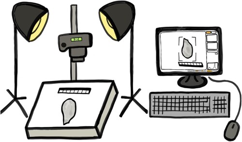
Photography protocols were developed to enable the digitization of a range of data, such as metric measurements, landmarks, and outlines. The photography equipment required by all collaborators includes: a digital camera, a macro lens, a copy stand or tripod, photography lights, flashes or a light box, a spirit level, materials for holding the artefacts down, a small photography scale and either a remote control, computer software for remote capture or a timer built into the camera. This equipment is commonly found within museums; however, funding should be sought to ensure that each collaborator has the necessary apparatus for the project. If purchased for the project, the equipment can be donated to the museums for future research and engagement opportunities, following guidance from the Wenner Gren Foundation. demonstrates an illustration of an example photography equipment set-up; each collaborator set-up should be checked by the PI through a video meeting and sample images produced for feedback before initiation of the full data collection period.
Figure 1. Cartoon of an example photography set-up, including a digital camera, a macro lens, a copy stand, photography lights, a spirit level, materials for holding the artefacts down, a small photography scale, and computer software for remote data capture.
Artefact position
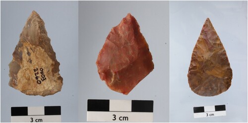
Each artefact should be photographed to capture both the dorsal (upper) and ventral (lower) surface. The artefacts should be secured to a contrasting background (usually white or gray colored) and leveled so they can be laid completely flat. Lithics with uneven ventral surfaces are likely to wobble onto one side; this should be corrected for by nesting the object using wedges to stabilize the artefact or by situating the artefact into sand, beads, or lab plasticine. It is important to not leave the artefact to rock, as any outlines or landmarks digitized from the photographs will not be homologous and make assumptions about the surface causing the rocking, with disproportionate and non-linear effects depending on the size of ridges causing wobble. Moreover, linear measurements taken from the photographs will also be impacted by distortion if the artefact is not secured completely flat. Finally, the artefact should be centered within the camera frame to minimize parallactic error in addition to a scale, which should be placed in the same plane as the artefact at a far enough distance to not interfere with data capture ().
Figure 2. Example photos of lithic points from Omo Kibish, Ethiopia. All points are photographed with their dorsal surface facing the camera. Photos taken by Dr Behailu Habte, National Museum of Ethiopia.
Camera position and settings
The posterior surface of the camera should be positioned at a set distance away from the artefact using a copy stand or a tripod. The camera needs to be leveled using the spirit level and recalibrated around once an hour to ensure it remains completely flat for the duration of the data capture. Each collaborator should use a macro lens to take the photographs, with corresponding focal lengths wherever possible. Macro lenses tend to produce less lens distortion than regular lens because the sensor produces an image of exact size and proportions of the artefact. Any distortion correction settings should be turned off and aperture priority mode turned on; this results in an appropriate shutter speed for the lighting conditions specific to the location so that the artefact remains in focus whilst capturing the detail of the artefact. Camera shake should be minimized by using remote capture computer software, a digital remote, or the timer built into the camera.
Lighting
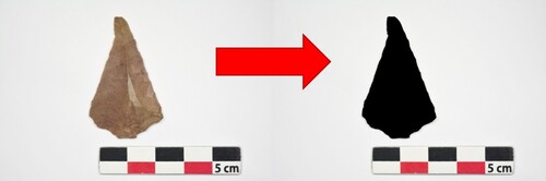
Lights should be positioned depending on the individual situation of the collaborator and the material properties of the artefact, with the primary aim of minimizing shadows around the artefact and highlighting features of interest. This usually means lighting the artefact from multiple different angles or with a light box. Shadows should be minimized as much as possible as they can interfere with image processing; for example, for outline based GMM, images should be binarized so that the outline can be clearly demarked, however when shadows are dark around the artefact, the binary threshold between what should be black (artefact) and what should be white (background) becomes harder to discern (). Shadows can also be minimized by placing the artefacts on top of an elevated transparent box – if this method is adopted, then the camera must be elevated at the specific height above the elevated artefacts rather than from the table. Lights should be carefully positioned to ensure that the artefact is well-defined, non-reflective and completely in focus.
Figure 3. Image binarization process of a lithic point from Ifri n’Ammar, Morocco. Photo taken by Mouna Qazzih, Institut National des Sciences de l’Archéologie et du Patriome, Morocco.
Measurement protocols
In general, when measuring lithic artefacts, they should be orientated so that striking platform is at the proximal end of the flake and the distal end is where the detaching fracture terminates. Measurements should be clearly defined and illustrated visually within the protocol documents to demonstrate the exact dimensions of interest. This is because measurements can either be defined by the technological characteristics of the lithic or by its morphology (Shea, Citation2020). For example, technological length of a flake relates to the distance between the fracture initiation point on the ridge between the ventral surface and the striking platform and the distal edge of the ventral surface at a perpendicular angle. On the other hand, morphological measurements, which are of more relevance to lithic shape, relate to the maximum dimensions of a flake – maximum length, maximum width (which is usually perpendicular to length, though note this can vary (Dogandžić et al., Citation2015) and so requires clear specification within the protocols), and maximum thickness (which is perpendicular to the dorsal/ventral plane). Morphological measurements of the platform also relate to the maximum values. The resolution of the measurements should be specified to ensure that the data is at a comparable precision; in most cases of lithic assemblages, a resolution of either 0.1 or 0.01 mm should be sufficient (Lyman & VanPool, Citation2009).
Data recording, storage and sharing
A spreadsheet should be provided to ensure metadata is recorded in a comparable format across collaborators, including details on the collection numbers, stratigraphy, context, raw material, and preservation of each artefact as well as the metric data and corresponding photograph numbers. Data can be stored on a communal data storage platform (such as a Google Drive) that each collaborator has access to, and external hard drives can be provided for data back-up. Following a discussion with each museum regarding the publication of the data, the resulting data could be uploaded onto an open-access digital archive if all parties give consent. All publications resulting from the data collected by the collaborators should elicit co-authorship and should be submitted to journals that are accessible to the collaborators – for example, for a project with African collaborators, articles should be submitted to African Archaeology Review and Journal of African Archaeology, and/or under a Gold or Green Open Access publishing agreement to ensure maximum accessibility (Marwick et al., Citation2017).
Discussion
This article has presented photography protocols for lithic shape documentation which can be implemented under a research model involving multiple observers. Whilst this approach has provided an initial strategy for overcoming COVID-19 related disruptions to museum or laboratory-based research on lithic assemblages, remote models of science that foster equitable international collaborations offer multiple benefits for the field far beyond the current crisis if adopted more widely. As such, the COVID-19 pandemic has the potential to offer an effective alternative to the way we usually conduct scientific research within museum settings by encouraging dual-project development across the Global North–South divide.
“Helicopter research” in the museum context
Douglass (Citation2020) proposes that the events of the COVID-19 pandemic should invite archaeologists to consider the concept of resilience as it relates to their research practices as well as their day-to-day life. This article argues that collaborative data collection with museum partners fosters research resilience by inviting local curators, researchers, and volunteers to be directly involved with international research projects conducted there. Often, foreign researchers travel to museum collections without extended interaction with museum staff or the local communities that have ancestral connections to the collections, even though these people likely possess the most contextual knowledge about the objects. Neo-colonial research, commonly known as “helicopter research”, limits the scientific knowledge gained from the data collection process, as conclusions from visiting scientists may be misinformed or simply perpetuate the assumptions of previous scholars (Nordling, Citation2021). More recently there has been increased awareness around such practices – for example, detailed engagement plans are required to undertake research at the Iziko Museums of South Africa. Moving forward, collaborative data collection models have the potential to provide local researchers with opportunities to assume prominent roles in the international research being conducted in their countries. African-led initiatives, such as those coordinated by the Turkana Basin Institute (Nordling, Citation2021), the Middle Awash Project (Sahle, Citation2021) and the Human Evolution Research Institute, University of Cape Town, have been extremely effective for building capacity within Africa; collaborative projects can contribute by allowing local scholars to benefit from international projects, though this needs to be coupled with more direct funding and support to even further facilitate African-led research.
Collaborative data collection should only be undertaken with the understanding that local researchers are included in all phases of the work, from planning to the research outputs, including co-authorship on publications resulting from the data collected. Douglass (Citation2020) describes the fully collaborative framework adopted by the Morombe Archaeological Project, working in the Vezo territories of coastal southwest Madagascar, where power-sharing initiatives have enabled research to persist throughout the COVID-19 pandemic. Such frameworks from the field can be applied within museum settings in order to mitigate pandemic-related disruptions, as well as to improve the quality and equity of the science produced, with input from all collaborators adding value and increasing diversity in understanding of the artefacts. Moreover, collaboration encourages local researchers to assume a central voice in the narrative of international archaeological research, which is especially important in places where the story of the past has been told by predominately Western scholars, who were typically white and male (Ackermann, Citation2019; Athreya & Ackermann, Citation2019; Sahle, Citation2021), such as within Africa, Australia, and North America. It is often in these regions where community building and respecting the cultural beliefs of local communities becomes particularly salient, as strong ancestral links to archaeological material persist. For example, First Nation groups in Canada have the power to decline archaeologists’ requests to study their ancestors’ remains (Nicholas, Citation2007), thus taking control over the narrative of their own heritage.
To accommodate COVID-19 related disruptions, most major research funders have allowed maximum flexibility and the reallocation of grants to meet the cost of working remotely (Stoye, Citation2020). Within a museum context, grants traditionally cover the training, travel, accommodation, and bench fees of foreign researchers to carry out research projects. This ultimately benefits the foreign PI and their development as a researcher, but also the wider community through the money spent by the PI during an in-country research visit. However, under a collaborative model, funding instead can be reallocated to ensure that local collaborators have the necessary equipment, training, skills, and provisioning to undertake the project. If equipment is purchased for the project, it can then be “donated” to the museum after the project has finished (as proposed under the guidance of the Wenner Gren Foundation) and used for future research and engagement projects led by local researchers. Investing in the training and development of students, interns and volunteers working at museum collections, perhaps in-person by a senior curator or virtually by international collaborators, is vital for ensuring that local early career researchers are equipped to conduct further research on museum collections and can provide long-term opportunities for often disadvantaged scholars (Nordling, Citation2021). Therefore, any spending that is inevitably lost through the PI not visiting physically can be made up for, or even superseded by, a direct investment into the country’s heritage sector by providing funded research opportunities for local scholars, which are rare in most countries. As proposed Scerri et al. (Citation2020), investing in the location of the data, not the location of the PI, is ultimately more sustainable for the field.
Reducing the carbon footprint of museum research
Archaeology, as a field-based science, has long been concerned by its carbon footprint (Reynolds, Citation2018). Interestingly, despite many archaeologists working with paleoenvironmental data and understanding the devastating effects climate change has had on past societies (e.g. Jackson et al., Citation2018), archaeologists often travel abroad multiple times a year, be it for fieldwork, conferences, or international collaborations. Museum-based research is no exception, with researchers sometimes flying to multiple countries within a single project to collect data on often very small samples. The sudden halt to domestic and international travel, and the slowing down of other human activities in the first half of 2020 saw a decrease in global carbon dioxide emissions by 8.8% (Liu et al., Citation2020) – whilst this is gradually increasing again as restrictions are released, the pandemic has revealed that reducing travel can have a significant beneficial impact on climate change and our planet.
Whilst concerned with the carbon footprint of their research, often archaeologists feel they have no choice but to conform to this research structure. Traditionally, to progress one’s academic career, one would need to generate new data, excavate a new archaeological site, or make new discoveries to produce publications. This pressure is especially felt by early career researchers, who have faced particular challenges during the COVID-19 pandemic due to the increased restrictions on time, funding and access to samples, yet they face competition in the job market with those who have not faced similar disruptions. Indeed, there is great value in analysing and aggregating pre-existing data (Timbrell, Citation2020), and nowadays most researchers are willing to share data thanks to the Open Science movement within archaeology (Marwick et al., Citation2017). Collaborative models of data collection can offer another solution for environmentally conscious researchers by facilitating the development of international networks of collaborators, providing an alternative means of collecting data from disparate collections.
The recent International Panel on Climatic Change report has warned that climate change is “widespread, rapid and intensifying” thanks to human activity with urgent action necessary to change the course of future climate change (IPCC, Citation2021), making it hard to justify the pre-pandemic level of travel undertaken by archaeologists. Therefore, adopting a collaborative model, whereby travel is not a necessity and data is shared as part of the collaboration, ensures that as much is gained from the data collection process as possible with relatively little cost to the environment. This article does not advocate that all travel related to archaeological research has to be avoided, but that a more mindful, nuanced, and considered approach should be taken when developing international projects; upon reflection, the adoption of a collaborative data collection models could be more appropriate in many scenarios, particularly when samples are small, numerous, and disparate. Future climate change has the potential to cause disruption to archaeological research, and indeed day to day life, therefore it is in our best interest as a field to find effective ways to reduce our carbon footprint.
Building resilience through collaborations with museums
Although the scholarly and professional value of engaging with artefacts and developing practical research skills within a physical museum is priceless, the potential value that can be gained makes the collaborative data collection model an effective alternative for accessing international lithic samples. Whether cooperative science produces data comparable to that typically collected by a single researcher remains currently untested (though see initial results from Timbrell Citation2022; indeed, Scerri et al. (Citation2020) propose that funding should be redirected to test the validity of remote methods of data generation. It is likely that the development of protocols to ensure consistency corrects for many, but not all, potential sources of error. For example, using lenses of different length, despite maintaining the height above the artefact, can still cause parallax issues, but this is largely a logistical limitation of the collaborative model whereby each museum either uses equipment that is already available is easy to source, or can be purchased within the financial scope of the project. Assessments of error in lithic studies involving multiple collaborators, particularly those of poorly standardized artefacts, require the conderidered application of specific methods that are able to partition variance between specimens from that which derives from error, in order to determine the effects of inter-observer variability on the results (see Fruciano, Citation2016; Lyman & VanPool, Citation2009; Ulijaszek & Kerr, Citation1999).
The protocols described in this article focus on the standardized digitization of lithic artefacts that can enable a variety of analyses. High-resolution photographs of lithics can be used to analyse morphological shape, as well as identify flake scars and wear damage. Moreover, photographs are a useful resource for digital archives and within museum displays when artefacts are taken out on loan. In fact, many museums are in the process of creating online archives through the digitization of their collections, and therefore collaborative research has the potential to support local researchers in this process, whilst also generating data on lithic collections for specific research purposes. Online databases of photographs may become vital for the training of students who are unable to get on-site field or museum experience, ultimately making archaeology more accessible. Additionally, photographic databases can also be used in a variety of research contexts such as for photogrammetry; this is relatively cheap and easy to teach virtually, and therefore has been proposed as another imaging method that could be suitable for remote science (Scerri et al., Citation2020). Both metric and photographic data generated under a collaborative model can also be re-used by local early career researchers for their own research purposes, such as for a university dissertation.
However, not all photographs will be suitable to be shared across a collaborative data collection framework; for example, images of human remains and culturally sensitive artefacts require a more nuanced data sharing agreement to ensure that the necessary communities retain control over who accesses the data (Tsosie et al., Citation2020; Walter et al., Citation2020). Any data generated under a collaborative research framework should be considered the responsibility of all parties involved, and therefore it’s publication, be it in a journal article, online repository or museum website, should be discussed at length prior to project intitation to ensure that all parties have given the necessary consent. In general, however, data sharing (such as through an online repository; Marwick et al., Citation2017) should be encouraged as part of the collaborative data collection model, as not only does this reduce the potential for future artefact damage, increase the accessibility of data for those who are unwilling and/or unable to travel extensively to access samples, encourage transparency and replicability which should be central to scientific practice, but it also may invite repatriation in some cases.
Conclusion
Human responses to past epidemics can be illuminated through archaeological research (Gamble et al., Citation2021); however, now we must use the COVID-19 pandemic to interrogate the ways in which we, as archaeologists, conduct international projects. This article presents an alternative to in-person research visits via a collaborative data collection model, which encourages the digitization of lithic artefacts that are remotely accessed through an equitable collaboration with local researchers. Under this model, data generation is decarbonized and decolonialised through a impactful dual-partnership approach to data collection. Collaborative data collection has the potential to provide a promising complement to in-person museum visits, with the COVID-19 pandemic providing the much-needed catalyst for the development of new frameworks of science that can ultimately make international research practices more accessible, sustainable, and equitable.
Acknowledgements
I would first like to thank the collaborators on this project: Sharon Manura, Simon Mboya, Christine Maroma, and Emmanuel Ndiema (National Museums of Kenya, Kenya), Behailu Habte, Yosef Tefera, and Sahleselasie Melaku (National Museum of Ethiopia, Ethiopia), Benjamin Marais and Wendy Black (Iziko Museums of South Africa, South Africa), Struan Henderson, Katherine Elmes, and Curtis Marean (Mossel Bay Archaeology Project, South Africa), Mouna Qazzih and Abdelouahed Ben-Ncer (Institut National des Sciences de l'Archéologie et du Patrimoine, Morocco), and Hélène Monod, Stéphanie Bonilauri, and Roland Nespoulet (Musée de l’Homme, France). Without you, this project would not be possible and so I am extremely grateful for your support, guidance, and continued collaboration, as well as many of your feedback on this article. I also thank my collaborators, Paloma de la Peña and Amy Way, for their ongoing support and cooperation on my project. I would like to acknowledge the site permit holders who allowed access to the archaeological material. I am also grateful to my supervisors, Matt Grove and Kimberly Plomp, who have been instrumental to the development of this project. I thank Ardern Hulme-Beaman for their helpful comments on this article and Rebecca Wragg-Sykes for assistance translating the protocols into French. I am very gracious for the flexibility and support of my funders (see details of funding). I also thank the two anonymous reviewers for their feedback and comments on this article.
Disclosure statement
No potential conflict of interest was reported by the author(s).
Additional information
Funding
Notes on contributors
Lucy Timbrell
Lucy Timbrell is a doctoral researcher at the University of Liverpool.
References
- Ackermann, R. R. (2019). Reflections on the history and legacy of scientific racism in South African paleoanthropology and beyond. Journal of Human Evolution, 126, 106–111. https://doi.org/10.1016/j.jhevol.2018.11.007
- Athreya, S., & Ackermann, R. R. (2019). Colonialism and narratives of human origins in Asia and Africa. In M. Porr & J. M. Matthews (Eds.), Interrogating human origins: Decolonisation and the deep past. Routledge. pp. 24. https://doi.org/10.4324/9780203731659-4
- Bennet, M. J. (2021). On the nature of extreme close-range photogrammetry: Visualisation and measurement of North African stone points. Code4Lib Journal, 51, ISSN 1940-5758.
- Bescoby, D. J. (2006). Detecting Roman land boundaries in aerial photographs using Radon transforms. Journal of Archaeological Science, 33(5), 735–743. https://doi.org/10.1016/j.jas.2005.10.012
- Bordes, F. (1961). Typologie du Paléolithique ancien et moyen. l’Université de Bordeaux.
- Buchanan, B., & Collard, M. (2010). A geometric morphometrics-based assessment of blade shape differences among Paleoindian projectile point types from western North America. Journal of Archaeological Science, 37(2), 350–359. https://doi.org/10.1016/j.jas.2009.09.047
- Buchanan, B., Collard, M., & O’Brien, M. J. (2020). Geometric morphometric analyses support incorporating the Goshen point type into plainview. American Antiquity, 85(1), 171–181. https://doi.org/10.1017/aaq.2019.89
- Cardillo, M. (2009, September 4–9). Temporal trends in the morphometric variation of the lithic projectile points during the middle holocene of Southern Andes (Puna Region). A coevolutionary approach. 15th congress of international union for prehistoric and protohistoric sciences. Workshop 22: Theoretical And methodological issues in evolutionary archaeology: Toward an unified darwinian paradigm, Lisbon, Portugal.
- Cardillo, M. (2010). Some applications of geometric morphometrics to archaeology. In A. M. T. Elewa (Ed.), Morphometrics for nonmorphometricians (pp. 325–341). Springer. https://doi.org/10.1007/978-3-540-95853-6_15
- Cerasoni, J. N. (2021). Vectorial application for the illustration of archaeological lithic artefacts using the “stone tools illustrations with vector art” (STIVA) method. PLOS ONE, 16(5), e0251466. https://doi.org/10.1371/journal.pone.0251466
- Chirikure, S. (2015). “Do as I say and not as I do”. On the gap between good ethics and reality in African archaeology. In A. Haber & N. Shepherd (Eds.), After ethics. Ethical archaeologies: The politics of social justice, Vol. 3. Springer. (pp. 27–37) https://doi.org/10.1007/978-1-4939-1689-4_3
- Davis, D. S., & Douglass, K. (2020). Aerial and spaceborne remote sensing in African archaeology: A review of current research and potential future avenues. African Archaeological Review, 37(1), 9–24. https://doi.org/10.1007/s10437-020-09373-y
- de la Peña, P. (2015). Refining our understanding of Howiesons Poort lithic technology: The evidence from grey rocky layer in Sibudu cave (KwaZulu-Natal, South Africa). PloS One, 10(12), e0143451. https://doi.org/10.1371/journal.pone.0143451
- Dogandžić, T., Braun, D. R., & McPherron, S. P. (2015). Edge length and surface area of a blank: Experimental assessment of measures, size predictions and utility. PLoS ONE, 10(9), e0133984. https://doi.org/10.1371/journal.pone.0133984
- Domingo, I., Carridon, B., Blanco, S., & Lerma, J. L. (2015). Evaluating convential and advanced visible image enhancement solutions to produce digital tracings at el Charche rock art shelter. Digital Applications in Archaeology and Cultural Heritage, 2(2–3), 79–88. https://doi.org/10.1016/j.daach.2015.01.001
- Domingo, I., Villaverde, V., López-Montalvo, E., Lerma, J. L., & Cabrelles, M. (2013). Latest developments in rock art recording: Towards an integral documentation of Levantine rock art sites combining 2D and 3D recording techniques. Journal of Archaeological Science, 40(4), 1879–1889. https://doi.org/10.1016/j.jas.2012.11.024
- Douglass, K. (2020). Amy ty lilin-draza’ay: Building archaeological practice on principles of community. African Archaeological Review, 37(3), 481–485. https://doi.org/10.1007/s10437-020-09404-8
- Douze, K., Igreja, M., Rots, V., Cnuts, D., & Porraz, G. (2020). Technology and function of middle stone age points. Insights from a combined approach at Bushman Rock Shelter, South Africa. In H. Groucutt (Ed.), Culture history and convergent evolution. Vertebrate paleobiology and paleoanthropology. Springer. (pp. 127–141). https://doi.org/10.1007/978-3-030-46126-3_7
- Earl, G., Basford, P. J., Bischoff, A. S., Bowman, A., Crowther, C., Dahl, J., Hodgson, M., Martinez, K., Isaksen, L., Pagi, H., Piquette, K. E., & Kotoula, E. (2011). Reflectance transformation imaging systems for ancient documentary artefacts. In J. P. Bowen, S. Dunn, & K. Ng (Eds.), EVA London 2011: Electronic visualisation and the arts (pp. 147–154). BCS.
- Evin, A., Bonhomme, V., & Claude, J. (2020). Optimising digitalization effort in morphometrics. Biology Methods and Protocols, 5(1), bpaa023. https://doi.org/10.1093/biomethods/bpaa023.
- Forni, G., Mantovani, A., & COVID-19 Commission of Accademia Nazionale dei Lincei, Rome. (2021). COVID-19 vaccines: Where we stand and challenges ahead. Cell Death & Differentiation 28(2): 626–639. https://doi.org/10.1038/s41418-020-00720-9
- Fowler, M. J. (2018). Aerial photography. The Encyclopedia of Archaeological Sciences, https://doi.org/10.1002/9781119188230.saseas0007
- Fruciano, C. (2016). Measurement error in geometric morphometrics. Development Genes and Evolution, 226(3), 139–158. https://doi.org/10.1007/s00427-016-0537-4
- Gamble, L., Claassen, C., Eerkens, J., Kennett, D., Lambert, P., Liebmann, M., Lyons, N., Mills, B. J., Rodning, C. B., Schneider, T. D., Silliman, S. W., Alt, S. M., Bamforth, D., Hays-Gilpin, K., Prentiss, A. M., & Rick, T. C. (2021). Finding archaeological relevance during a pandemic and what comes after. American Antiquity, 86(1), 2–22. https://doi.org/10.1017/aaq.2020.94
- Gunz, P., & Mitteroecker, P. (2013). Semilandmarks: A method for quantifying curves and surfaces. Hystrix: The Italian Journal of Mammalogy, 24(1), 103–109. https://doi.org/10.4404/hystrix-24.1-6292
- Howell, D. (2018). The potential of hyperspectral imaging for researching colour on artefacts. In K. Kelley & R. L. Wood (Eds.), Digital imaging of artefacts: Developments in methods and aims. (pp. 37–49). Archaeopress.
- Inizan, M.-L. (1999). Technology and terminology of knapped stone. Cercle de Recherches et d’Etudes Préhistoriques.
- Iovita, R. (2009). Ontogenetic scaling and lithic systematics: Method and application. Journal of Archaeological Science, 36(7), 1447–1457. https://doi.org/10.1016/j.jas.2009.02.008
- Iovita, R. (2011). Shape variation in aterian tanged tools and the origins of projectile technology: A morphometric perspective on stone tool function. PLOS One, 6(12), e29029. https://doi.org/10.1371/journal.pone.0029029
- IPCC. (2021). Climate change 2021: The physical science basis. In V. Masson-Delmotte, P. Zhai, A. Pirani, S. L. Connors, C. Péan, S. Berger, N. Caud, Y. Chen, L. Goldfarb, M. I. Gomis, M. Huang, K. Leitzell, E. Lonnoy, J. B. R. Matthews, T. K. Maycock, T. Waterfield, O. Yelekçi, R. Yu, & B. Zhou (Eds.), Contribution of working group I to the sixth assessment report of the intergovernmental panel on climate change. Cambridge University Press, In Press.
- Ivanovaitė, L., Serwatka, K., Hoggard, C. S., Sauer, F., & Riede, F. (2020). All these fantastic cultures? Research history and regionalization in the Late Palaeolithic tanged point cultures of Eastern Europe. European Journal of Archaeology, 23(2), 162–185. https://doi.org/10.1017/eaa.2019.59
- Jackson, R. C., Dugmore, A. J., & Riede, F. (2018). Rediscovering lessons of adaptation from the past. Global Environmental Change, 52, 58–65. https://doi.org/10.1016/j.gloenvcha.2018.05.006
- Kersten, T. P., & Lindstaedt, M. (2012). Image-based low-cost systems for automatic 3D recording and modelling of archaeological finds and objects. In M. Ioannides, D. Fritsch, J. Leissner, R. Davies, F. Remondino, & R. Caffo (Eds.), Progress in cultural heritage preservation (pp. 1–10). Springer. https://doi.org/10.1007/978-3-642-34234-9_1
- Klingenberg, C. (2008). Novelty and ‘homology-free’ morphometrics: What’s in a name? Evolutionary Biology, 35(3), 186–190. https://doi.org/10.1007/s11692-008-9029-4
- Krause, P., Szekely, O., Bloom, M., Christia, F., Daly, S., Lawson, C., Marks, Z., Milliff, A., Miura, K., Nielsen, R., Reno, W., Souleimanov, E. A., & Zakayo, A. (2021). COVID-19 and fieldwork: Challenges and solutions. PS – Political Science & Politics, 54(2), 264–269. https://doi.org/10.1017/S1049096520001754
- Liu, Z., Ciais, P., Deng, Z., Lei, R., Davis, S.J., Feng, S., Zheng, B., Cui, D., Dou, X., Zhu., Guo, R., Ke, P., Sun, T., Lu, C., He., Wang, Y., Yue, X., Wang, Y., Leo, Y … Schnellnhuber, H.J. (2020). Near-real-time monitoring of global CO2 emissions reveals the effects of the COVID-19 pandemic. Nature Communications, 11(1), 5172. https://doi.org/10.1038/s41467-020-18922-7
- Loy, A., & Slice, D. E. (2010). Image data banks and geometric morphometrics. In P. L. Nimis & R. Vignes Lebbe (Eds.), Tools for identifying biodiversity: Progress and problems. (pp. 243–248). EUT Edizioni Università di Trieste.
- Lycett, S. J. (2009). Quantifying transitions: Morphometric approaches to Palaeolithic variability and technological change. In M. Camps & P. Chauhan (Eds.), Sourcebook of paleolithic transitions: Methods, theories, and interpretations (pp. 79–92). Springer. https://doi.org/10.1007/978-0-387-76487-0_5.
- Lyman, L. L., & VanPool, T. L. (2009). Metric data in archaeology: A study of intra-analyst and inter-analyst variation. American Antiquity, 74(3), 485–504. https://doi.org/10.1017/S0002731600048721
- Magnani, M., Douglass, M., Schroder, W., Reeves, J., & Braun, D. (2020). The digital revolution to come: Photogrammetry in archaeological practice. American Antiquity, 85(4), 737–760. https://doi.org/10.1017/aaq.2020.59
- Marwick, B., d’Alpoim Guedes, J., Barton, C. M., Bates, M., Baxter, M., Bevan, A., Bollwerk, E.A., Bocinsky, R.K., Brughmans, T., Carter, A.K., Conrad, C., Contreras, D.A., Costa, S., Crema, E.R., Dagget, A., Davies, B., Drake, L., Dye, T.S., France, P. … Wren, C.D. (2017). Open science in archaeology. SAA Archaeological Record, 17(4), 8–14. https://doi.org/10.17605/OSF.IO/3D6XX
- Matzig, D. N., Hussain, S. T., & Riede, F. (2021). Design space constraints and the cultural taxonomy of European final Palaeolithic large tanged points: A comparison of typological, landmark-based and whole-outline geometric morphometric approaches. Journal of Palaeolithic Archaeology, 4(4), 27. https://doi.org/10.1007/s41982-021-00097-2
- McNabb, J. (2017). Journeys in space and time. Assessing the link between acheulean handaxes and genetic explanations. Journal of Archaeological Science: Reports, 13, 403. https://doi.org/10.1016/j.jasrep.2017.04.010.
- Menendez, L. (2017). Comparing methods to assess intraobserver measurement error of 3D craniofacial landmarks using geometric morphometrics through a digitizer arm. Journal of Forensic Sciences, 62(3), 741–746. https://doi.org/10.1111/1556-4029.13301
- Mesfin, I., Leplongeon, A., Pleurdeau, D., & Borel, A. (2020). Using morphometrics to reappraise old collections: The study case of the Congo Basin middle stone age bifacial industry. Journal of Lithic Studies, 7(1), https://doi.org/10.2218/jls.4329
- Miles, J., Pitts, M., Pagi, H., & Earl, G. (2014). New applications of photogrammetry and reflectance transformation imaging to an Easter Island statue. Antiquity, 88(340), 596–605. https://doi.org/10.1017/S0003598X00101206
- Mitteroecker, P. (2021). Morphometrics in evolutionary developmental biology. In L. Nuño de la Rosa & G. B. Muller (Eds.), Evolutionary development biology (pp. 941–951). Springer. https://doi.org/10.1007/978-3-319-32979-6_119
- Mullin, S. K., & Taylor, P. J. (2002). The effects of parallax on geometric morphometric data. Computers in Biology and Medicine, 32(6), 455–464. https://doi.org/10.1016/S0010-4825(02)00037-9
- Musson, C., Rog, P., & Stefano, C. (2013). Flights into the past. Aerial Photography, Photo Interpretation and Mapping for Archaeology, https://doi.org/10.11588/propylaeumdok.00002009
- Newman, S. E. (2015). Applications of reflectance transformation imaging (RTI) to the study of bone surface modifications. Journal of Archaeological Science, 53, 536–549. https://doi.org/10.1016/j.jas.2014.11.019
- Nicholas, G. (2007). The past and future of Indigenous archaeology: Global challenges, North American perspectives, Australian prospects. Australian Archaeology, 52, 129–139. https://doi.org/10.1080/03122417.2001.11681703
- Nordling, L. (2021). Raising up African paleoanthropologists. SAPIENS Anthropology Magazine. https://www.sapiens.org/biology/african-paleoanthropologists/
- Ogundiran, A. (2020). The COVID-19 pandemic: Perspectives for reimaging and reimagining archaeological practice. African Archaeological Review, 37(3), 471–473. https://doi.org/10.1007/s10437-020-09408-4
- Okumura, M., & Araujo, A. G. M. (2018). Archaeology, biology, and borrowing: A critical examination of geometric morphometrics in archaeology. Journal of Archaeological Science, 101, 149–158. https://doi.org/10.1016/j.jas.2017.09.015
- Petřík, J., Sosna, D., Prokeš, L., Štefanisko, D., & Galeta, P. (2018). Shape matters: Assessing regional variation of Bell Beaker projectile points in Central Europe using geometric morphometrics. Journal of Archaeological and Anthropological Sciences, 10(4), 893–904. https://doi.org/10.1007/s12520-016-0423-z
- Picollo, M., Cucci, C., Casini, A., & Stefani, L. (2020). Hyper-spectral imaging technique in the cultural heritage field: New possible scenarios. Sensors, 20(10), 2843. https://doi.org/10.3390/s20102843
- Reynolds, N. (2018). Decarbonising archaeology. Nature Ecology and Evolution: News and Opinion. https://natureecoevocommunity.nature.com/posts/40589-cognitive-dissonance-and-archaeological-practice-the-challenge-of-decarbonising-a-discipline
- Roe, D. A. (1964). The British lower and middle paleolithic: Some problems, methods of study and preliminary results. Proceedings of the Prehistoric Society, 30, 245–267. https://doi.org/10.1017/S0079497X00015140
- Sahle, Y. (2021). Media review: Fossil men: The quest for the oldest skeleton and the origins of humankind. American Journal of Physical Anthropology, 176(2), 340–341. https://doi.org/10.1002/ajpa.24359
- Scerri, E. M. L., Kühnert, D., Blinkhorn, J., Groucutt, H.S., Roberts, P., Nicoll, K., Zerboni, A., Orijemie, E.A., Barton, H., Candy, I., Goldstein, S.T., Hawks, J., Niang, K., N'Dah, D., Petraglia, M.D. & Vella, N.C. (2020). Field-based sciences must transform in response to COVID-19. Nature Ecology and Evolution, 4(12), 1571–1574. https://doi.org/10.1038/s41559-020-01317-8
- Scerri, E. M. L., Gravina, B., Blinkhorn, J., & Delagnes, A. (2016). Can lithic attribute analyses identify discrete reduction trajectories? A quantitative study using refitted lithic sets. Journal of Archaeological Method and Theory, 23(2), 669–691. https://doi.org/10.1007/s10816-015-9255-x
- Serwatka, K., & Riede, F. (2016). 2D geometric morphometric analysis casts doubt on the validity of large tanged points as cultural markers in the European final palaeolithic. Journal of Archaeological Science: Reports, 9, 150–159. https://doi.org/10.1016/j.jasrep.2016.07.018
- Shea, J. J. (2020). Prehistoric stone tools of Eastern Africa: A guide. Cambridge University Press.
- Shott, M. J. (1997). Stones and shaft redux: The metric discrimination of chipped-stone dart and arrow points. American Antiquity, 62(1), 86–102. https://doi.org/10.2307/282380
- Shott, M. J., & Trail, B. W. (2010). Exploring new approaches to lithic analysis: Laser scanning and geometric morphometrics. Lithic Technology, 35(2), 195–220. https://doi.org/10.1080/01977261.2010.11721090
- Simpson, G. G., Roe, A., & Lewontin, R. C. (1960). Quantitative zoology (Rev ed.). Harcourt, Brace.
- Stoye, E. (2020). How research funders are tackling coronavirus disruption. Nature News, https://doi.org/10.1038/d41586-020-01120-2
- Timbrell, L. (2020). Strength in numbers: Combining old datasets to answer new questions. In K. Kaercher, M. Arntz, N. Bomentre, X. L. Hermoso Buxán, K. Day, S. Ki, R. Macleod, H. Muñoz Mojado, L. Timbrell, & I. Wisher (Eds.), New frontiers in archaeology: Proceedings of the Cambridge annual student archaeology conference 2019. (pp. 1–4). Archaeopress. ISBN 978-1-78969-794-0.
- Timbrell, L., & Plomp, K. (2019). Using the shape of the basicranial portion of the temporal bone to distinguish between relatively closely-related human populations. Journal of Archaeological Science: Reports, 26, 101885. https://doi.org/10.1016/j.jasrep.2019.101885
- Timbrell, L., Scott, C., Habte, B., Tefra, Y., Monod, H., Qazzih, M., Marais, B., Black, W., Maroma, C., Ndiema, E., Henderson, S., Elmes, K., Plomp, K., & Grove, M. (2022). Testing inter-observer error under a collaborative research framework for studying lithic shape variability. 22 June 2022, PREPRINT (Version 1) available at Research Square. [https://doi.org/10.21203/rs.3.rs-1752934/v1] .
- Tsosie, K. S., Yracheta, J. M., Kolopenuk, J., & Smith, R. A. (2020). Letter to the editor: Indigenous data sovereignties and data sharing in biological anthropology. American Journal of Physical Anthropology, 174(2): 183–6. https://doi.org/10.1002/ajpa.24184
- Ulijaszek, S. J., & Kerr, D. A. (1999). Anthropometric measurement error and the assessment of nutritional status. British Journal of Nutrition, 82(3), 165–177. https://doi.org/10.1017/s0007114599001348
- Walter, M., Lovett, R., Maher, B., Williamson, B., Prehn, J., Bodkin-Andrews, G., & Lee, V. (2020). Indigenous data sovereignty in the era of big data and open data. Australian Social Policy Issues. Special Issue: Big Data and Social Policy in Australia, 56(2), 143–156. https://doi.org/10.1002/ajs4.141
- Wang, L.-Y., & Marwick, B. (2020). Standardization of ceramic shape: A case study of iron age pottery from northeastern Taiwan. Journal of Archaeological Science: Reports, 33, 102554. https://doi.org/10.1016/j.jasrep.2020.102554