
ABSTRACT
Using global data, this article examines the nexus of transboundary flood events and future social vulnerability. Which international river basins are forecast to experience an increase in both hydrological variability and population in the future, but currently lack institutional provisions to deal with these shared events? Concentrations of elevated risk are found in several basins in Central Asia, Central America and Central Africa. The article ends by highlighting transboundary basins that merit further investigation and possibly additional institution building to reduce urban flood risk.
Introduction
As deltas remain the most densely populated areas in the world and will continue to attract more human activity as well as further urbanization in the coming decades (UN, Citation2014), the impacts of floods will continue to increase worldwide. Surface water flooding disasters are among the world’s most frequent and damaging types of disasters. River flooding affects the lives of 21 million people on average annually, causing US$ 521 billion in reduced GDP (WRI, Citation2015). In addition, predictions are that global climate change will bring more extreme events and greater variability in the timing and quantity of precipitation in some parts of the world, which may increase flood risk (Guha-Sapir, Hoyois, & Below, Citation2013; IPCC, Citation2008; Kundzewicz, Citation2012; Kundzewicz, Pińskwar, & Brakenridge, Citation2013; Steinführer et al., Citation2009). This is why there is an ongoing search for better ways of protecting human life, land, property and the environment through improved flood management.
Flood (risk) management has proven to be challenging when dealing with transboundary floods, i.e., floods originating in one country or jurisdiction and then propagating downstream to another country or jurisdiction. When there is a lack of preparedness or capacity to address challenges like a shared flood, the population in shared river basins becomes more vulnerable. If, on the other hand, transboundary waters are appropriately managed, human security and development are made less vulnerable (Jägerskog, Citation2013). Also, to reduce the chances of (threatened) armed conflict over water resources, international cooperation and management in all aspects of transboundary flood management should be able to absorb changes in the basin, either through institutional mechanisms or through management of the physical system (Wolf, Yoffe, & Giordano, Citation2003).
While (surface) water has led to disputes,Footnote1 Giordano and Wolf (Citation2001) showed that where relatively strong, sustainable institutions are in place, international water disputes get resolved.Footnote2 However, institutions for joint management of transboundary waters are often missing (Bakker, Citation2009; Jägerskog, Citation2013; Schmeier, Citation2012), which seems illogical since, at the time of this study, 276 river basins around the world are shared by two or more nations,Footnote3 and the catchment areas that contribute to these rivers cover approximately 42% of the land surface of the earth, include 40% of the world’s population, and contribute almost 80% of freshwater flow (De Stefano et al., Citation2012; Wolf et al., Citation2003).
All over the globe, examples can be found where coordinated flood management has reduced the risks of shared flood events, and on paper, the need to focus on floods at a river basin scale is indeed accepted by major institutions like the European Union (FMRD, Citation2007; EC Citation2007) and the UN Development Programme (UNDP, Citation2006).Footnote4 But tackling flood management at the river basin scale means synchronizing the policies, legislation, regulations and ordinances, emergency responses, data collection, and technical standards of all riparians. Because these issues differ from one country to another, it has been difficult, if not impossible, to set up binding legislation and regulations (Schmeier, Citation2014; UNECE, Citation2009).Footnote5 As a result, floods often continue to be overlooked in transboundary water management, although Bakker (Citation2009) showed that not managing these risks has consequences: flood losses were higher in shared basins that lacked the institutional capacity to manage these events.
Other researchers have looked into vulnerability of water resources to climate change (e.g., Kundzewicz et al., Citation2008; Oki & Kanae, Citation2006; Van Beek, Wada, & Bierkens, Citation2011; Vörösmarty, Green, Salisbury, & Lammers, Citation2000), the impacts of climate change on the occurrence and characteristics of floods (Alfieri, Burek, Feyen, & Forzieri, Citation2015; Arnell & Gosling, Citation2014; Van Aalst, Citation2006), vulnerability to climate change of specific countries, regions and river basins (Bär, Rouholahnejad, Rahman, Abbaspour, & Lehmann, Citation2015; Conway, Citation2005; Nijssen, O’Donnell, Hamlet, & Lettenmaier, Citation2001; UNEP-DHI, Citation2011), and the presence of treaties and/or river basin organizations (RBOs) (Bakker, Citation2009; Cooley & Gleick, Citation2011; Delli Priscoli, Citation2009; Dombrowsky, Citation2007; Lautze, Wegerich, Kazbekov, & Yakubov, Citation2013; Schmeier, Citation2012; Wolf et al., Citation2003).
The present research aims to combine the above-mentioned aspects with an explicit focus on floods. We refine current data and research on institutional capacity derived from treaties as listed in the Transboundary Freshwater Dispute Database (TFDD, Citation2016, http://www.transboundarywaters.orst.edu; see also De Stefano et al., Citation2012; Giordano et al., Citation2014; Yoffe et al., Citation2004) by looking at the role an international RBO with a flood mandate and treaty composition play in flood management. International river basins are stratified by the type of climate-related stress they may face in terms of both hydrological change and the projected increase in flood-exposed urban population. This updated information on international river basins and floods is merged and weighted to produce a vulnerability ranking specific to floods and the institutions designed to manage them. By including future regimes of climate variability and population growth, this analysis highlights those basins with potential institutional weaknesses with respect to urban flood exposure, which could lead to future hydro-political stress, and will indicate whether there is sufficient institutional capacity to deal with the increasing flood risks all across the globe.
The remainder of this article is structured as follows. Methods, data and analysis will be explained, after which the results will be presented by continent. The final part clarifies which international river basins will have to strive to increase their institutional capacity to deal with the increasing risk of transboundary floods.
Methods, data and analysis
This study develops a relative ranking of risk for each basin–country combination (referred to as a basin-country unit, or BCU, further defined in ‘Data sources and spatial framework’) according to that unit’s institutional, hydrological and population characteristics. By modifying and expanding the ranking methods of De Stefano et al. (Citation2012), a new global data-set of potential risk is developed that specifically addresses flood risk and the interacting effect of increasing urban population. As basins face the interacting pressures of increases in urban population exposed to flooding and climate-driven changes in flood regimes, the presence or absence of institutions to mitigate those impacts becomes critical. By mapping the distribution of these factors ranked relative to each other, gaps and areas deserving further study can be uncovered.
For each basin-country combination, risk was calculated using the following steps:
Rank BCUs according to the institutions present and their vulnerability to flood hazards.
Rank the potential for increased interannual hydrological variability in the BCU.
Rank relative increases in exposed population (exposure) in the BCU.
Combine into a composite ranking of risk for the BCU.
The spatial framework and data sources are described, followed by a description of how the previous rankings of institutional vulnerability and hydrological exposure from De Stefano et al. (Citation2012) were modified to accommodate new data and the focus on flood hazard, followed by the adaptation of a spatial urban population forecast model to assess relative increases in exposed population, and concluding with how these separate rankings are combined into a composite model of risk.
After ranking all BCUs, we use a method analogous to that presented by De Stefano et al. (Citation2012) to identify those BCUs with relatively equal contributions to their parent basins in terms of flood-exposed urban population. Thus, if there are four riparians, and each BCU has approximately one-fourth of the flood-exposed urban population of the basin as a whole, each BCU contributes a roughly equal portion of the basin-wide exposed urban population. Compare that to the situation in another four-riparian basin where one riparian has 90% of the exposed urban population. By quantifying this relative measure of evenness, we stratified all BCUs with urban population and examined the quartile with the highest evenness. The reason for using this metric is that focusing on basins with more equal urban populations at the BCU level to strengthen transboundary regimes to prevent urban flood exposure could have more traction than in situations where one riparian has the large majority of the exposed urban population.
Data sources and spatial framework
The foundation for this study is the TFDD, which houses a diverse body of spatial, legal, institutional and political information about the international river basins of the world. Following the pattern set by the TFDD, the unit of analysis for this study is the basin-country unit, defined as the spatial portion of a transboundary basin within a single country (De Stefano et al., Citation2012). For example, the Chira basin, shared between Peru and Ecuador, is analyzed separately as the Chira-Peru BCU and the Chira-Ecuador BCU. By using this unit of analysis, we can expose within-basin differences in institutional coverage, as opposed to merely finding differences between basins. With 276 transboundary basins and 148 riparian countries, there are a total of 747 BCUs (Section A in the supplemental online data, at https://doi.org/10.1080/02508060.2017.1331412) covering approximately 62 million km2 of the planet’s land mass and encompassing an estimated 2.7 billion people (De Stefano et al., Citation2012).Footnote6 Because the BCUs are used as the aggregator for more continuous variables such as runoff variability and population change, they introduce artificial ‘boundaries’ into the final visualization of the resulting rankings.
To link in institutional information, the TFDD database of over 640 treaty documents was used. This database includes an analysis of the content of each treaty along more than 40 dimensions of water management, from non-water linkages to conflict resolution to allocation mechanisms, and links these treaties to the corresponding spatial units (Giordano et al., Citation2014). New data on RBOs are now available, with an expanded accounting of the world’s RBOs and more detailed data on the areas of focus of each RBO (Bakker, Citation2007; Schmeier, Citation2012).
Hydrological hazard as defined by De Stefano et al. (Citation2012) was used for this study. Briefly, hydrological hazard is categorized based on a combination of current variability and potential increased variability using the interannual coefficient of variation (CV) in runoff. This metric allows us to focus on the variability in flows rather than averages over time, as these extremes can present greater management challenges in a transboundary context (Cooley & Gleick, Citation2011; Drieschova, Giordano, & Fischhendler, Citation2008). Historical baselines of runoff variability were simulated by driving a hydrological model (CLIVAR) with historical climate data for 1961–1990. Future runoff variability was quantified by driving the same hydrological model with outputs from the IPCC AR4 A1B emissions scenario and projecting out to the period 2045–2055, using a subset of models. To assess the largest potential departures from historical regimes, the scenarios producing the largest increase in variability for each BCU were used. See De Stefano et al. (Citation2012) for a detailed explanation of the models and selection criteria.
Modelled data on potential changes in urban population exposed to flooding were provided by the Netherlands Environmental Assessment Agency (Ligtvoet & Hilderink, Citation2014), and represent an effort to model both increasing flood risk and changing demographics, combining projections of increasing urban population with increasing flood risk as represented by affected population and affected GDP by 2050. Exposed population for all cities with more than 500,000 inhabitants was estimated for both 2010 (468 cities) and 2050 (670 cities, due to projected population growth). This study considered all cities falling inside transboundary basins with some level of flood exposure.
By focusing objectively on the quantitative aspects of institutional capacity related to climate variability, population growth and floods, we aim to find potential hotspots of hydro-political tension as related to flood management and related response in the world’s transboundary basins.
Vulnerability: gaps in transboundary institutional capacity
Adapting the vulnerability ranking mechanisms described in detail in De Stefano et al. (Citation2012) and building on the expanded RBO data, BCUs were given a cumulative score from 0 to 5 based on the presence of specific mechanisms relevant to transboundary flood management:
Any type of treaty (Section C in the supplemental online data)
An allocation mechanism addressing flood control or management
A variability management mechanism specifically addressing floods
A conflict resolution mechanism
An RBO with a specific mandate for flood management
The resulting score was aggregated to a VULNERABILITY score of high (0 or 1 mechanism present), medium (2 or 3) or low (4 or 5).
Variability: ranking the variability of the hydrological regime
Using the historic and projected interannual CV in modelled runoff, a ranking (VARIABILITY) of BCU hydrological hazard was computed from a combination of historic runoff variability regimes and projected increases. BCUs were first ranked based on historical interannual runoff CV as low (CV < 0.25), medium (0.25 ≤ CV ≤ 0.75) or high (CV > 0.75), and if not already high based on historical variability, that ranking was increased by one step if the projected increase in variability was greater than 15%.
Exposure: ranking increases in urban population exposed to flooding
The populations of all cities with more than 500,000 inhabitants in each BCU that are exposed to flooding (‘exposed population’) for 2010 (EXPOSURE2010) and 2050 (EXPOSURE2050) were summed. From this, the proportional increase in exposed population (EXPOSUREchange) between the two time periods was calculated:
and the mean of EXPOSUREchange across all BCUs (EXPOSUREmean) was used to stratify the results into an exposure ranking (EXPOSURE). Each BCU was assigned a ranking based on whether it fell above or below the mean, with rankings of low (EXPOSUREchange = 0 or EXPOSURE2010 = 0; no exposed population or no increase), medium (0 < EXPOSUREchange ≤ EXPOSUREmean), or high (EXPOSUREchange > EXPOSUREmean).
Risk: combining institutional vulnerability, flood-exposed urban population and hydrological variability
With the ranking of BCUs along three dimensions – institutional vulnerability, runoff variability regimes and changing exposure of urban populations – the final step combines the numerical representations (0= low, 1= medium, 2= high) of those rankings additively into a ranking of urban flood risk under changing climate:
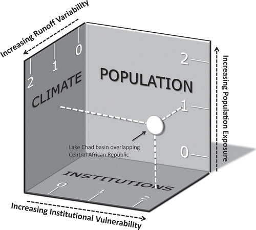
shows a conceptual diagram of this risk ranking for the Lake Chad–Central African Republic BCU. Using this approach, risk can range from 0 to 6, with values of 5 or 6 indicating that the risk is a result of all three factors (vulnerability, variability and exposure), and values of 3 or 4 indicating that at least two of the three factors are present.
Figure 1. Example showing the combination of various rankings into a single risk ranking for the Lake Chad–Central African Republic basin-country unit.
Results
This section highlights the most striking results for each of the variables, by continent.
Vulnerability: present institutional capacity
Institutional vulnerability to floods, expressed here as the presence of certain treaty mechanisms and an RBO with a flood mandate, shows variation across the continents (). Prominent basins lacking formal institutional capacity are the Amazon basin in South America and several basins in Europe: the Dnieper, Ebro and Seine, and a couple of basins in Scandinavia. High institutional vulnerability in Asia is prominent in the Ob and Amur basins, among others.
Figure 2. Ranking of current transboundary institutional vulnerability to flooding, based on contributing treaty mechanisms and presence of river basin organizations with a flood management mandate.
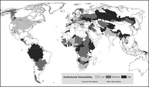
This definition of institutional vulnerability differs from that initially proposed by De Stefano et al. (Citation2012) because it narrows the institutional focus to just flood resilience. As a result, the global geography of coverage is different, as BCUs are ranked lower than in the 2012 study. This happens because some treaties that provided resilience under the broader definition, such as a treaty dealing with droughts, are no longer counted in the ranking used here. As would be expected, there is a general downwards trend in scores. Importantly, we find that Africa and South America no longer have any BCUs with all components present, and only 16 BCUs are covered by all components. In terms of areas and counts of BCUs in each score level, the results are not extremely divergent, but the picture is strikingly different when considering the population covered.
Nearly two billion people, or roughly 72% of the world’s transboundary population, are in basins that experience a decrease in treaty rank. One basin, the La Plata between Brazil and Ecuador, encompasses nearly 50 million people, and moved from a score of 5 to a score of 2. Some 73 BCUs, encompassing 524 million people, dropped by 2 levels, and 187 BCUs, encompassing 1.419 billion people, dropped by 1. Interestingly, nine BCUs actually increased in score by 1, encompassing 11 million people, primarily in Europe and South Asia, largely as a result of the improved RBO data newly available to this study (Schmeier, Citation2014). The remainder (475 BCUs) saw no change.
The differences across all continents are stark () when comparing distributions of population among scores between this ranking and that used by De Stefano et al. (Citation2012). Much of this is driven by decreases of 1, but in Asia, nearly 278 million people are in BCUs with decreases of 2, including the multiple riparians in the Helmand, Aral Sea and Mekong basins. In Africa, 141 million people are in BCUs with decreases of 2, including basins such as the Nile, Gambia and Okavango.
Figure 3. Changes in population coverage in each treaty score category between (bottom) institutions encompassing all forms of variability management (the definition used by De Stefano et al., Citation2012) and (top) the flood-specific ranking of institutions used in this article.
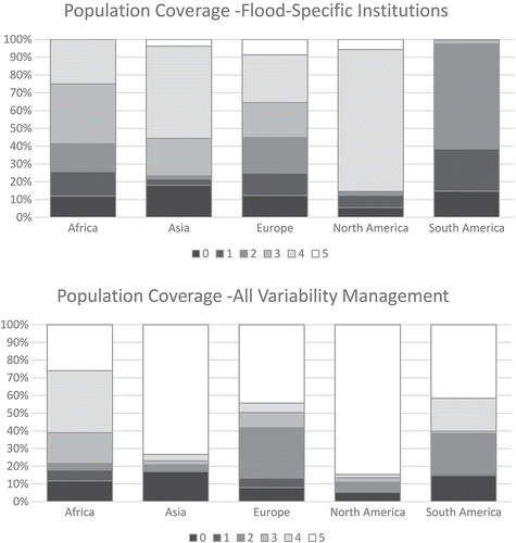
On a global level, 13 of the 532 treaties analyzed include flood specifics (Sections B and C in the supplemental online data). None of these treaties cover for basins in Africa; most of them are for European basins.
Africa
Almost half of all the African BCUs (107) do not have treaties on transboundary cooperation over shared waters. Of the 64 basins, 39 basins do not have a treaty between any constituent riparians. None of the treaties deal with climatic variability, and none of the RBOs have a specific flood mandate (Section B in the supplemental online data). Most of the treaties in Africa are for the Nile basin (25), the Zambezi (14) or the Niger (15).
Asia
In Asia, 32 basins do not have treaties, and 32 do. The basins in Asia with the most treaties are the Ganges (17), Aral Sea (12), Tigris (11), Jordan (11) and Mekong (10). All of them have RBOs as well. Two of the treaties deal with climate extremes and have provisions for floods: the Mekong Treaty and the Peace Treaty between Israel and Jordan. Lastly, the RBO for the Ob River has a specific flood mandate; the other RBOs do not.
Europe
In Europe, 46 basins have treaties related to water, and 36 do not. Most treaties are found in the Rhine (49) and the Danube (47) basins; the Rhone has 15, and the Pasvik, 10. Overall, eight treaties deal with climate extremes; most of them cover the Oder or the Danube. RBOs for the Rhine, Danube and Elbe have specific flood mandates.
North America
Basins in North America with treaties are the Saint Lawrence (27), the Colorado (24) and the Rio Grande (23). Eighteen of the 47 basins do not have treaties; none of the RBOs present have flood mandates.
South America
Nine of the 29 basins in South America have treaties; the La Plata has 28, and Lake Titicaca and the Amazon each have 6. All three basins have RBOs. None of the treaties or RBOs deal with climatic variability, however.
Variability: changes in runoff variability regimes by 2050
For this analysis, the same ranking methodology for future climate variability was used as described by De Stefano et al. (Citation2012); see . Because the BCU-level rankings have not changed, we limit our discussion of specific patterns to other sections where this variability change is combined with institutional and population aspects of risk.
In brief, hydrological hazard was found to increase over the present due to the increasing interannual variability simulated by the various constituent models. Baseline variability was higher in the tropics and subtropics, and less so in higher latitudes. In 2050, 23% of all BCUs are at the highest hazard level, due to either existing variability or large increases in variability. These increases are distributed fairly evenly across continents, with 30%, 62% and 8% of the current population living in areas of low, moderate and high future hazard, respectively (see ).
Exposure: changes in flood-exposed urban population by 2050
We looked at the number of people currently exposed to floods, and how many will be exposed in the future, and ranked the relative change into levels of increased population exposure over time (). In transboundary basins, an estimated 15.9 million urban residents are exposed to some level of flood risk, and this number is projected to nearly double by 2050 based just on urban growth. Of the 751 BCUs, 206 will see an increase in urban population, 28 may see a decrease, and the remainder were either not modelled or were projected to have no change. Some 73 BCUs are in the highest exposure rank (above the mean global increase), while 134 are in the moderate exposure rank.
Figure 4. Ranking of hydrological hazard, defined by current runoff variability regimes combined with increases in runoff variability in 2050 as compared to 2000.
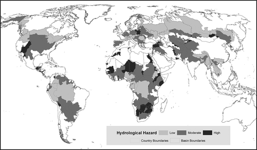
Figure 5. Ranking of increases in exposed population by basin-country units, from 2010 to 2050.
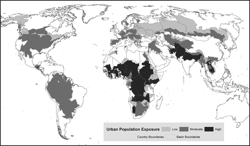
Africa and Asia stand out for the number of BCUs in the highest exposure categories, while Russia and Eastern Europe are interesting for their decreases or lack of growth (). Of the 73 highest-ranked BCUs, 48 are in Africa, 20 are in Central and Southeast Asia and 4 are in Central America. We present results by continent in the following sections.
Africa
The African continent shows the full spectrum of possibilities, with many basins showing little or no relative increase, while others are at the high end of all BCUs analyzed. In 48 African BCUs, the increase will be large, with exposed population increases ranging from 130% to more than seven-fold in the Ugandan portion of the Nile. These highest-ranked BCUs are projected to see 2.8 million people newly exposed and cover areas totalling 12.69 million km2.
Several major basins (Congo/Zaire, Niger, Nile, Zambezi, Senegal and Lake Chad) are going to see large increases in exposed population across most of their riparians. There are also a number of smaller West African basins with potentially large increases in exposure, including the portions of the Volta shared between Ghana and Burkina Faso.
Asia
Asia is second to Africa in the number of BCUs ranked highly for population exposure increases, with 20 BCUs in that category. These BCUs are projected to add 7.4 million people and cover 3.47 million km2 of land area. The two areas of concentration are in the Vietnamese and Cambodian portions of the Mekong, and the Indus and Ganges-Brahmaputra-Meghna basins of the Himalayan arc overlapping Afghanistan, Pakistan, India and Bangladesh. Smaller increases are found in the Middle East and northern Central Asia, while many Russian portions of large basins in North Asia will see no increase or even declining exposure.
Europe
The bulk of the growth in exposed population in Europe occurs in Western and Central Europe, where 40 BCUs totalling 1.92 million km2 are expected to see moderate gains. These BCUs range from the Vistula in Poland and the Danube in Romania westward to Spain, with no increase projected in only a few BCUs in between.
North and Central America
The remaining four high-ranked BCUs for exposed population increase are in Central America: three in Guatemala (the Grijalva, Lempa and Motaqua basins) and one in Belize (the Belize basin). The projected increase in exposed population for these four basins is under 50,000, and the land area is relatively small. However, this relatively small area already has an estimated six million people. Most of the BCUs in the rest of North America can expect increased population exposure, except those in Alaska and north-western Canada, and a few smaller border basins between the US, Mexico and Canada. For the entire continent, the exposed population is projected to increase by 386,000 before 2050.
South America
South America has no BCUs with high projected exposure increases in 2050. However, with the exception of small units in the Chilean/Argentinian Andes and coastal basins in Guyana, Suriname and French Guiana, moderate increases are projected in many of the continent’s BCUs. These range from an increase of 5,000 people in the Guyana portion of the Essequibo to an increase from 40,000 to 86,000 people in the Bolivian portion of the Amazon, adding an estimated total of 344,000 people to the exposed urban population in 23 of South America’s 92 BCUs.
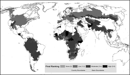
Risk: combining institutional vulnerability, exposed urban population, and runoff variability related to transboundary floods; identifying future bottlenecks
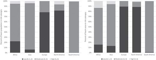
Combining the ranks of institutional vulnerability, future climate-driven variability, and increases in population exposed to flooding into a ranking of risk, we can present a more holistic ranking of the gaps in resiliency for basins and their constituent BCUs (). Risk is broken out into categories based on the number of contributing factors: ‘high’ is all three factors present (score of 5 or 6), ‘moderate’ is at least two factors present (score of 3 or 4), and ‘low’ is one or no factor present (score of 0 to 2). Thus, the highest level of risk is no RBO and no treaties addressing floods specifically at present; a large predicted increase in exposed population; and increasing variability in climate-driven runoff. There are 40 BCUs with this rank, including three basins in Africa and one in Central America that score a 6. In the moderate-risk category are 415 BCUs, and 296 are in the lowest-risk category.
Figure 6. Proportions of basin population (left) and area (right) in each level of final risk ranking, grouped by continent.
The highest risk level includes four BCUs of particular note: the Lempa in Guatemala, the Asi/Orontes in Turkey, the Aral Sea in Afghanistan and the Kura-Araks in Turkey, totalling 8.6 million people in those BCUs alone (across the entire BCU), with approximately 70 million people in the larger corresponding basins (across the entire basin, for the entire urban population). Of those BCUs in the moderate-risk category scoring a 4, notable BCUs are the Hari/Harirud in Iran, the Amazon in Bolivia, the Congo/Zaire in the Republic of Congo, Lake Chad in Chad, and the Aral Sea in Tajikistan and Turkmenistan.
Remarkably, only 25 BCUs receive a risk score of zero, and many of these are very small fragments that may be artefacts of political history or the limitations of the geographic data. However, there are several substantial units that do not have any of the risk factors identified in this study, such as the Canadian Saint Lawrence and Colorado BCUs, the Swiss portion of the Rhine and the Czech portion of the Oder.
With regard to population, 102 million people (3.6% of the total transboundary population) are in basins at the highest risk levels; 73% of those people are in Africa and 22% in Asia. With respect to area, 3.4 million km2 (5.5% of total transboundary area) is in the highest risk levels. In contrast to population, the majority of land at the highest risk is in Asia (56%), while 31% is in Africa. Europe and North America see similar patterns, with most land and population falling in the lowest risk categories, while most of South America is in moderate-risk categories using either metric ().
Figure 7. Combined ranking of risk based on current institutional vulnerability, and increases in exposed population and hydrological variability by 2050.
Relatively few basins fall at either extreme of final risk. We do see that most of those with high final risk rankings have treaties, but tend to have low RBO scores: the Bia, Geba and Juba-Shibeli basins in Africa, and the Lempa basin in Central America, all have constituent riparians that received a 6.
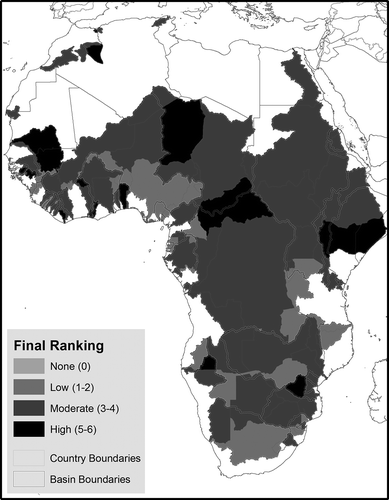
Africa
On average, basins on the African continent have a very high final risk; most of them lack RBOs, and almost half of all the African BCUs (107) do not have treaties on transboundary cooperation over shared waters – 74 of those rank 3 or higher in final risk (). The majority of the treaties present in Africa are for the Nile basin, the Zambezi or the Niger, but these still rank 3 or 4 in final risk, while the Senegal, with 11 treaties, ranks 5. The exception is the Juba-Shibeli – a final score of 6, but with three treaties it does not have RBOs and has the highest rank of final risk possible. Also notable is that the Central African Republic, falling inside the Lake Chad and Congo/Zaire basins, receives a 5 for final risk, driven by low institutional factors, high population growth and moderate runoff variability.
Figure 8. Final risk rankings of basin-country units in Africa.
Asia
Asian river basins will experience moderate to low increases in exposed population, but the final risk ranking is high for all the basins experiencing this increased exposure (). Furthermore, not all of these basins have treaties, and except for the Aral Sea, Amur, Tigris, and Ob, no RBOs are present either. Of all basins, the Song Vam Co Dong is the only basin with an overall high risk ranking, with moderate increase of exposed population, no treaties and no RBOs. Though exposed population will increase, the Mekong River basin has an overall low risk ranking with respect to climate, because of the low likelihood of climate-driven changes in flow and high institutional capacity on the river basin in the form of a treaty specifically designed to handle shared flood events. The Kura-Araks basin in Asia, identified as a high-risk basin by De Stefano et al. (Citation2012), remains high-risk in this study as well – in addition to very low institutional scores, and moderate climate exposure, certain riparian countries (Georgia, Turkey and Armenia) will experience an increase in exposed population. The Ganges and Indus basins exhibit a clear mediating effect of treaties: both basins have moderate final risk rankings, despite very large expected growth and some existing variability in the hydrological system. Pakistan and India have a long-standing treaty governing their shared waters that covers conflict resolution, flood management, and allocation concerns. This high-scoring institutional component offsets potentially large growth in flood-exposed population and an already variable hydrological regime for those two riparians.
Figure 9. Final risk rankings of basin-country units in Asia.
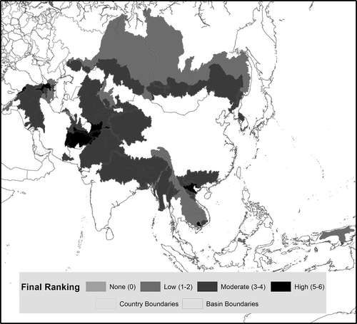
Figure 10. Final risk rankings of basin-country units in Europe.
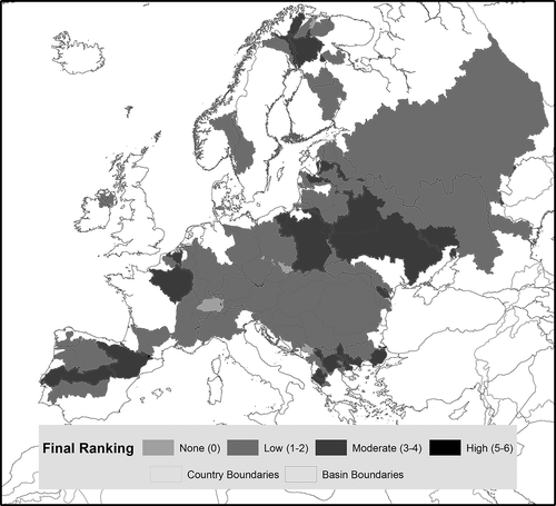
Figure 11. Final risk rankings of basin-country units in North America.
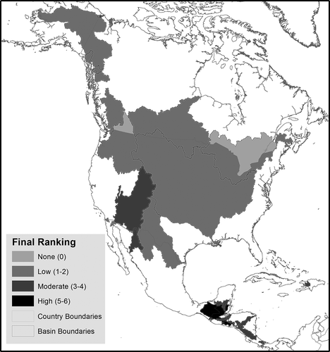
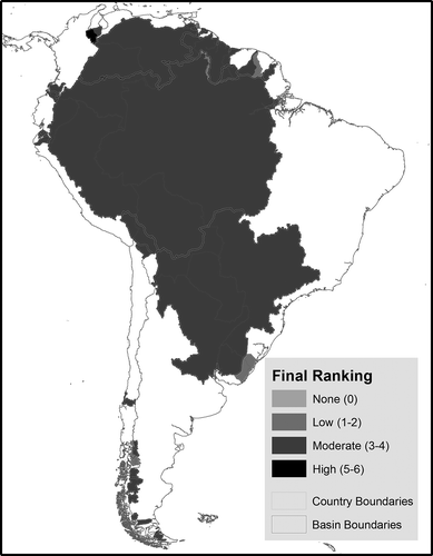
Figure 12. Final risk rankings of basin-country units in South America.
Europe
While Europe has many basins scoring a 3 or higher in final risk, the exposed populations in those basins are small, and most of them have a wide array of treaties and RBOs. In contrast to the patterns of large population-exposure changes discussed above, the opposite spatial pattern is seen for risk, where Eastern Europe is high, while Central/Western Europe is lower, and only 20% of BCUs are projected to see any increase in population exposure at all. Outliers are the Ebro, Tagus and Garonne (). European basins will experience an increase in exposed population, but the increase will be moderate or small. All basins with an increase have treaties, varying from one (Ebro, Seine, Drin, Vijose) to close to 50 (Rhine and Danube). Not all of them have RBOs, and all of them have average-to-high ranks for final risk. Moderate population exposure increases also compound moderate climate and institutional rankings in some smaller basins in the Balkans region, notably the Maritsa shared between Greece and Turkey, the Albanian portions of the Vijose and Lake Prespa basins, and the Macedonia portion of the Vardar basin.
North America
Basins with high overall ranks can largely be found in Central America, and most of these have treaties. In Central America, the Grijalva basin stands out with both the Mexican and Guatemalan portions in the highest risk category. The Lempa basin also falls in the highest category for both El Salvador and Guatemala. The Colorado basin is ranked at moderate risk due to climate-driven exposure in Mexico, and both climate and population-driven exposure in the US ().
South America
A variety of interacting factors yields a relatively smooth distribution in South America. Most of the continent’s basins are in the moderate-risk category (). Since increases in urban exposure are largely constant across the continent, it is either climate variability in the higher-latitude regions or institutional gaps in the Amazonian region at play, rarely both, and this leads to the relatively even risk. The Catatumbo basin, a relatively small basin shared between Venezuela and Colombia, is the only basin with a constituent BCU receiving a final score of 5. This basin has neither treaties nor RBOs and a moderate increase in exposed population rank. In the north, the Orinoco and Essequibo basins are both at higher risk levels, as are headwater portions of the Amazon and Lake Titicaca-Poopo basins.
Discussion
This study enhances our understanding of future urbanization and flood risk coupled with environmental and social changes in transboundary basins, and whether states are prepared with the institutional tools to handle these. Using a ranking system for each contributing factor, a global map was made of risk based on the existing transboundary institutional capacity focused on shared flood management, current and future climate variability, and future population growth.
This study extends a global filtering methodology (De Stefano et al., Citation2012) to a more focused topic (flood management capacity) and additional data (current and future exposure of urban populations to flooding). With this approach, we can identify basins that might come under increasing tension related to shared water resources affecting urban areas in the future. These are basins and associated riparians that might face challenges without the corresponding institutional mechanisms to manage conflict over the resource. Because water management can present opportunities for both conflict and cooperation (in both prevention and emergency response), understanding the current and potential future distribution of contributing social and environmental factors will allow managers and policy makers to make more targeted inquiries related to urbanization and managing water systems under climate change.
As described, the global geography of coverage changes, because we use a narrower, different definition of vulnerability to focus in on flood management; as a result, BCUs are ranked lower than they were by De Stefano et al. (Citation2012). This divergence results specifically from considering only allocation of high flows, the limiting of RBOs to those involved in flood management in some way, and the restriction of variability management mechanisms to those that specifically address high flows (as opposed to droughts).
With respect to data completeness, we would like to point to the Helmand, a basin with a score of 5 for final risk. In our data, we only have the Helmand River Commission listed. There is a reference in the TFDD to the 1973 Helmand River Treaty,Footnote7 but without any data attached to it – it is not coded and hence did not show up in our spatial analysis. The Afghan and Iranian portions of the Helmand basin also receive high scores of 5 for final risk, with greater population exposure driving Afghanistan’s score while high climate exposure drives Iran’s score. It is not unlikely that this is the case for some other basins as well; institutional capacity may not be listed or show up in database and Internet searches and hence not count in the analysis. Other transboundary elements related to financing mechanisms, agreements on data sharing, notification and consultation, enforcement mechanisms, etc., which could all be very relevant to proper transboundary flood management, were also not included.
Financial risk, of interest to for example the (re)insurance industry, was also not included in the analyses. The hydrological-variability data used for this study were derived from global climate models and hydrological models that may not match well with local conditions. Uncertainty remains in climate projections, and the hydrological models did not incorporate human alteration of rivers, such as impoundment.
Our results correlate well with assessments made by the World Resources Institute (Citation2015), Alfieri et al. (Citation2015) and Arnell and Gosling (Citation2014). The World Resources Institute concludes that the number of people affected by floods will more than double by 2030, while Alfieri et al. conclude that on average, flood peaks with a return period of 100 years or more will double in frequency within the next 30 years in Europe. Arnell and Gosling give the example that in 2050, total global flood risk will increase by 187% compared to a situation without climate change.
When comparing our results with those of De Stefano et al. (Citation2012) and Bakker (Citation2007) we see that several basins are identified in two or all of the studies, namely the Juba-Shibeli, Congo/Zaire, Lake Chad, Kura-Araks, Asi-Orontes and Catatumbo basins. The four basins identified in our study as having high-risk BCUs and relatively even urban population distribution probably warrant further investigation, namely the Lempa, Asi/Orontes, Aral Sea and Kura-Araks. In addition to the high-risk portion of the Aral Sea overlapping Afghanistan, Turkmenistan and Tajikistan also have moderate risk levels and relatively similar levels of exposed urban population. While this is not the only way to stratify risk rankings, it does provide insight into where the particular challenge of protecting flood-exposed urban populations might be more equally shared across multiple riparians.
There are basins with a high final risk ranking that nevertheless have high institutional capacity, like the Aral and Danube basins. While this is largely a function of our more restrictive definition of institutional capacity to focus on resilience to flooding, one could also question whether those basins are vulnerable despite the presence of institutional capacity, or less, but still very, vulnerable because of these treaties and organizations. Consistent with previous studies like those of Dinar, Katz, De Stefano, and Blankespoor (Citation2014) and Cooley and Gleick (Citation2011), we concur that these treaties do modulate the risk posed by climate variability, compared to basins that do not have treaties, but future research should confirm this theory. However, basins with a history of tension and shared water resource challenges are probably predisposed to establish more treaties and/or RBOs to mitigate those tensions, complicating the cause–effect relationship and making interpretation more difficult. Also, not all cooperation is good, and not all conflict is bad; Zeitoun and Mirumachi (Citation2008) argue that treaties and RBOs often solidify power inequities, while the theory of hydro-hegemony suggests that the hydro-hegemon can create its preferred mechanisms of transboundary water management due to its relative power within the watershed (Zeitoun & Warner, Citation2006).
Conclusions
There are clear hotspots that emerge from this analysis, and they do not always occur in the basins traditionally examined in the literature. Indeed, some of the most popular target basins for discussion of conflict (Nile, Mekong) do not emerge in this analysis. This highlights the fact that this approach is ranking a subset of drivers for conflict, and can provide insight about this particular combination, not overall conflict potential as a whole.
The predominance of African BCUs in the global picture highlights the intersection between population growth and transboundary water regimes and underscores the potential for large population growth in the continent’s cities. Indeed, the population of Nigeria, already the most populous country in Africa, is projected to increase more than fivefold by 2100 (Gerland et al., Citation2014), and according to our assessment of risk, the flood-exposed population in large cities of the Democratic Republic of Congo in transboundary basins plays a major role in elevating the urban flood risk of these basins. While risk is uniform in South America, it arises for different reasons in different basins, and thus requires a look at the underlying causes in evaluating where additional attention might be paid, and what factors to pay attention to. The emergence of the Grijalva and Lempa basins in Central America demonstrate the potential synergistic challenges of the social and environmental factors, as these basins were not particularly remarkable in past analyses. The most interesting picture in South Asia is found in the Ganges-Brahmaputra-Meghna basin. The population growth in the riparians will be substantial, and there are gaps in institutional frameworks that may hinder mitigation of flooding risk for some of the more vulnerable populations in the region.
Risk is best examined at the intersection of transboundary basins and riparian countries. Basin–country combinations are critical for understanding the overlapping factors that contribute to urban flood exposure and climate change, and challenge us to use the most precise geography possible in investigating these issues. This study is primarily designed to deal with questions of change and preparedness. Nations and localities have a history of dealing with urbanization and its attendant challenges – it is a known process with analogues to learn from.
With respect to potential climate change impacts at the basin level, changes in the hydrological system may move the basin into a new regime not experienced in the recent past. This is particularly relevant for international mechanisms, as the vast majority of treaties were signed in the last century (Giordano et al., Citation2014), a relatively short time when considering global changes in climate systems. The basin conditions going forward – for instance in the renegotiation process for the Columbia River Treaty in 2024 – may be novel and unmatched by historical conditions that the riparian nations were responding to in forming those treaties in the past. Thus, the use of a metric scaled to the basin–country combination is key in identifying hot-spots of risk. Using this method, one can quickly detect that institutional gaps drive risk in Nepal and Bhutan, while India is subject to more climate hazard than other riparians, sharpening the overall picture of the Ganges-Brahmaputra-Meghna basin and what might drive future tensions.
This risk ranking is a topic-specific coarse filter. Because our definition of institutional capacity is focused solely on international agreements, the reality on the ground will rely on a much wider range of social and economic factors. Addressing a local-level phenomenon such as urban vulnerability to flooding will require understanding the local and regional context. However, evaluating all those peculiarities in a common framework is a daunting if not impossible task. Global approaches such as this provide a general guide to relative risks along our chosen dimensions. This does not invalidate the consideration of international-scale institutions, as those can be enormously influential on the options available to localities as they manage water resources, and provide a safe place to start negotiating needs for integrated management. Throughout the literature, the common examples for this are the Mekong River Commission and the Nile Basin Initiative – both play important, sometimes disputed roles in flood management and hydroelectric development in the entire basin, and serve(d) as fruitful negotiating arenas for all water-related issues.
Future research possibilities include the upstream/downstream dynamics – are there capacity mismatches between upstream and downstream cities in basins that lack transboundary institutions? The global data-set of flood return and magnitude by Arnell and Gosling (Citation2014) could be used in such analyses to address interesting social-ecological questions at the basin scale. Next to that, the quality and effectiveness of institutions was not part of this analysis; the results are purely based on paper evidence. In practice, institutional capacity could be far greater or smaller than evidenced by documents and the absence or presence of institutions. Imaginable next steps would be to select a few cases and measure the actual effectiveness, capacity or performance of the institutions present in those basins, as done for instance by USAID (Citation2011), UNDP (Citation2010) and Backer (Citation2006).
The final findings of this article increase our current knowledge on transboundary flood events, projected variability regimes related to the waters shared between countries, and flood-related institutional capacity. By also incorporating future regimes of climate variability and population growth, we have identified those areas with the greatest need for higher resilience in their institutional systems to absorb or adapt to transboundary floods in the coming decades.
Supplemental data.pdf
Download PDF (166.3 KB)Acknowledgements
The authors wish to thank Lucía De Stefano, Aaron Wolf, Todd Jarvis and Peter Driessen for their useful comments on a first draft of this article.
Disclosure statement
No potential conflict of interest was reported by the authors.
Supplemental data
Supplemental data for this article can be accessed here.
Notes
1. For instance, between Arabs and Israelis, Indians and Bangladeshis, Americans and Mexicans, and among all Nile basin riparians (Wolf, Citation1999).
2. Examples are the treaties signed between Sudan and Egypt, Russia and China, the countries in the Euphrates basin, and most recently the groundwater treaty between Jordan and Saudi Arabia (Eckstein, Citationn.d.).
3. This number has grown as a result of new analysis to 286 as a result of the Transboundary Waters Assessment Programme (http://twap-rivers.org).
4. The purpose of the Columbia River Basin Treaty between Canada and the US is to optimize flood management and power generation. Another ‘good practice’ example can be found in the Vuoksi River basin, shared between Russia and Finland: a treaty was signed in 1993 in which Finland is permitted to release or retain water from its reservoirs to balance the water flow (Sanchez & Roberts, Citation2014; WWAP, Citation2012). Yet another example can be found in the Mekong River basin, where the Agreement on the Cooperation for Sustainable Development was signed listing ‘flood control’ for the ‘mutual benefits of all riparians and to minimize the harmful effects that might result from natural occurrences and man-made activities’ (MRC, Citation1995) as one of their fields of cooperation.
5. The EU Floods Directive for instance, while recognizing the varying nature of flood risk, is more a process of action; cooperation requirements between riparians are not prominently included (Suykens, Citation2015).
6. Recent work by the Transboundary Waters Assessment Programme (http://twap-rivers.org) has greatly refined the global data-set of basins, adding an additional 10 basins and significantly changing the geography of others. But at the time this study was conducted, those data were not available.
7. International Water Law Project Blog, ‘The Helmand River and the Afghan-Iranian Treaty of 1973’, 23 July 2015 (http://www.internationalwaterlaw.org/blog/2015/07/23/the-helmand-river-and-the-afghan-iranian-treaty-of-1973/).
References
- Alfieri, L., Burek, P., Feyen, L., & Forzieri, G. (2015). Global warming increases the frequency of river floods in Europe. Hydrology and Earth System Sciences Discussions, 12, 1119–1152. doi:10.5194/hessd-12-1119-2015
- Arnell, N. W., & Gosling, S. M. (2014). The impacts of climate change on river flood risk at the global scale. Climatic Change. doi:10.1007/s10584-014-1084-5
- Backer, E. (2006). Paper tiger meets while elephant. An analysis of the effectiveness of the mekong river regime. Lysaker: Fridtjof Nansens Institute.
- Bakker, M. H. N. 2007. Transboundary river floods: Vulnerability of continents, international river basins and countries (Ph.D. Dissertation). Oregon State University.
- Bakker, M. H. N. (2009). Transboundary river floods and international river basin institutions. JAWRA Journal of the American Water Resources Association, 45(3), 553–566. doi:10.1111/j.1752-1688.2009.00325.x
- Bär, R., Rouholahnejad, E., Rahman, K., Abbaspour, K. C., & Lehmann, A. (2015). Climate change and agricultural water resources: A vulnerability assessment of the Black Sea catchment. Environmental Science & Policy, 46, 57–69. doi:10.1016/j.envsci.2014.04.008
- Conway, D. (2005). From headwater tributaries to international river: Observing and adapting to climate variability and change in the Nile basin. Global Environmental Change, 15(2), 99–114. doi:10.1016/j.gloenvcha.2005.01.003
- Cooley, H., & Gleick, P. H. (2011). Climate-proofing transboundary water agreements. Hydrological Sciences Journal, 56(4), 711–718. doi:10.1080/02626667.2011.576651
- De Stefano, L., Duncan, J., Dinar, S., Stahl, K., Strzepek, K. M., & Wolf, A. T. (2012). Climate change and the institutional resilience of international river basins. Journal of Peace Research, 49, 193–209. doi:10.1177/0022343311427416
- Delli Priscoli, J. (2009). River Basin Organizations. In J. Delli Priscolli & A. T. Wolf (Eds.), Managing and transforming water conflicts (pp. 135–168). Cambridge: Cambridge University Press.
- Dinar, S., Katz, D., De Stefano, L., & Blankespoor, B. 2014. Climate change, conflict, and cooperation: Global analysis of the resilience of international river treaties to increased water variability (Policy Research working paper; no. WPS 6916). Washington, DC: World Bank Group. http://documents.worldbank.org/curated/en/2014/06/19646108/climate-change-conflict-cooperation-global-analysis-resilience-international-river-treaties-increased-water-variability
- Dombrowsky, I. (2007). Conflict, cooperation and institutions in international water management: An economic analysis. Cheltenham, UK: Edward Elgar Publishing.
- Drieschova, A., Giordano, M. A., & Fischhendler, I. (2008). Governance mechanisms to address flow variability in water treaties. Global Environmental Change, 18(2), 285–295. doi:10.1016/j.gloenvcha.2008.01.005
- EC. (2007). Communication from the Commission to the European Parliament and the Council, Addressing the challenge of water scarcity and droughts in the European Union, COM (2007) 414 final. Brussels: European Commission.
- Eckstein, G. n.d. The Newest Transboundary Aquifer Agreement: Jordan and Saudi Arabia Cooperate Over the Al-Sag /Al-Disi Aquifer. Retrieved September 28, 2015, from http://www.internationalwaterlaw.org/blog/2015/08/31/the-newest-transboundary-aquifer-agreement-jordan-and-saudi-arabia-cooperate-over-the-al-sag-al-disi-aquifer/
- FMRD. (2007). Directive 2007/60/EC on the assessment and management of flood risks. Official Journal of the European Union, European Parliament and European Council.
- Gerland, P., Raftery, A. E., Ševčíková, H., Li, N., Gu, D., Spoorenberg, T., … Wilmoth, J. (2014, October 10). World population stabilization unlikely this century. Science, 346(6206), 234–237. Published online 18 September 2014. doi:10.1126/science.1257469
- Giordano, M. A., Drieschova, A., Duncan, J. A., Sayama, Y., De Stefano, L., & Wolf, A. T. (2014). A review of the evolution and state of transboundary freshwater treaties. International Environmental Agreements, 14, 245–264. doi:10.1007/s10784-013-9211-8
- Giordano, M. A., & Wolf, A. T. (2001). Incorporating equity into international water agreements. Social Justice Research, 14(4), 349–366. doi:10.1023/A:1014646511293
- Guha-Sapir, D., Hoyois, P., & Below, R. (2013). Annual disaster statistical review 2012: The numbers and trends. Brussels: CRED.
- IPCC. (2008). Climate change and water. In Technical paper VI, 2008, 94. Geneva: Intergovernmental Panel on Climate Change.
- Jägerskog, A. (2013).Transboundary water management – why it is important and why it needs to be developed. In Free flow – Reaching water security through cooperation. Paris: UNESCO.
- Kundzewicz, Z. W. (Ed.). (2012). Changes in flood risk in Europe. Wallingford: IAHS Press.
- Kundzewicz, Z. W., Mata, L. J., Arnell, N. W., Döll, P., Jimenez, B., Miller, K., … Shiklomanov, I. (2008). The implications of projected climate change for freshwater resources and their management. Hydrological Sciences Journal, 53(1), 3–10. doi:10.1623/hysj.53.1.3
- Kundzewicz, Z. W., Pińskwar, I., & Brakenridge, R. (2013). Large floods in Europe, 1985-2009. Hydrol Sciences Journal, 58(3), 736–736. doi:10.1080/02626667.2013.781318
- Lautze, J., Wegerich, K., Kazbekov, J., & Yakubov, M. (2013). International river basin organizations: Variation, options and insights. Water International, 38(1), 30–42. doi:10.1080/02508060.2013.747418
- Ligtvoet, W., & Hilderink, H. (Eds.) (2014) Towards a world of cities in 2050 – an outlook on water-related challenges. Background report to the UN-Habitat Global Report. The Hague: PBL Netherlands Environmental Assessment Agency.
- Mekong River Commission (MRC). (1995, April 5). Agreement on the cooperation for the sustainable development of the Mekong River Basin. Phnom Penh: Mekong River Commission.
- Nijssen, B., O’Donnell, G. M., Hamlet, A. F., & Lettenmaier, D. P. (2001). Hydrologic sensitivity of global rivers to climate change. Climatic Change, 50(1–2), 143–175. doi:10.1023/A:1010616428763
- Oki, T., & Kanae, S. (2006, August). Global hydrological cycles and world water resources. Science, 313(5790), 1068–1072. doi:10.1126/science.1128845
- Sanchez, J. C., & Roberts, J. (Eds.). (2014). Transboundary water governance. Adaptation to climate change. Switzerland: IUCN, Glanz.
- Schmeier, S. 2012. Governing international watercourses (The Contribution of River Basin Organizations to the Effective Governance of Internationally Shared Rivers and Lakes). London: Routledge. Retrieved from http://www.routledge.com/books/details/9780415623582/
- Schmeier, S. (2014). River Basin organizations lost in translation? Transboundary River Basin governance between science and policy. In A. Bhaduri, J. Bogardi, J. Leentvaar, & S. Marx (Eds.), The global water system in the anthropocene. Challenges for science and governance (pp. 369–383). Berlin: Springer.
- Steinführer, A., Kuhlicke, C., De Marchi, B., Scolobig, A., Tapsell, S., & Tunstall, S. 2009. Local communities at risk from flooding. Social vulnerability, resilience and recommendations for flood risk management in Europe (Final report for FLOODsite). Grimma: Winterwork.
- Suykens, C. (2015). EU water quantity management in international River Basin districts: Crystal clear? European Energy and Environmental Law Review, 24(6), 134–143.
- Transboundary Freshwater Dispute Database (TFDD) Online database. (2016, February 20). Corvallis, OR: Oregon State University.
- UNEP-DHI. (2011). Methodology for the GEF transboundary waters assessment programme. Volume 4. Methodology for the assessment of transboundary River Basins (pp. viii + 147). Nairobi: UNEP.
- United Nations Development Programme. 2006. Human development report 2006 (Published for the United Nations Development Programme (UNDP). Beyond scarcity: Power, poverty and the global water crisis). United Nations Development Programme, New York.
- United Nations Development Programme. (2010). Measuring capacity. New York: Capacity Development Group, Bureau for Development Policy. UNDP.
- United Nations Economic Commission for Europe (UNECE). (2009). Transboundary flood risk management: Experiences from the UNECE region. New York and Geneva: United Nations.
- United Nations, Department of Economic and Social Affairs, Population Division. (2014). World urbanization prospects: The 2014 revision, highlights. In (ST/ESA/SER.A/352). New York: UNDESA.
- USAID/TIPS. (2011). Measuring institutional capacity. In A supplemental reference to the Automated Directive Service (ADS) Chapter 203. Washington, DC: USAID.
- Van Aalst, M. K. (2006). The impacts of climate change on the risk of natural disasters. Disasters, 30(1), 5–18. doi:10.1111/disa.2006.30.issue-1
- Van Beek, L. P. H., Wada, Y., & Bierkens, M. F. P. (2011). Global monthly water stress: 1. Water balance and water availability. Water Resources Research, 47(7). doi:10.1029/2010WR009791
- Vörösmarty, C. J., Green, P., Salisbury, J., & Lammers, R. B. (2000). Global water resources: vulnerability from climate change and population growth. Science, 289, 284. doi:10.1126/science.289.5477.284
- Wolf, A. T. (1999, February 1). Criteria for equitable allocations: The heart of international water conflict. Natural Resources Forum, 23, 3–30. doi:10.1111/narf.1999.23.issue-1
- Wolf, A. T., Yoffe, S. B., & Giordano, M. (2003). International waters: Identifying basins at risk. Water Policy, 5(2003), 29–60.
- World Resources Institute (WRI). (2015). World’s 15 Countries with the Most People Exposed to River Floods. Retrieved July 24, 2015, from http://www.wri.org/resources/maps/aqueduct-global-flood-analyzer
- World Water Assessment Programme (WWAP). (2012). The United Nations world water development report 3, case study volume: Facing the challenges. Paris: UNESCO.
- Yoffe, S., Fiske, G., Giordano, M. Giordano, M., Larson, K., Stahl, K. and Wolf, A. T. (2004). Geography of international water conflict and cooperation: Data sets and applications. Water Resources Research, 40, W05S04–593. doi:10.1029/2003WR002530
- Zeitoun, M., & Mirumachi, N. (2008). Transboundary water interaction I: Reconsidering conflict and cooperation. International Environmental Agreements-Politics Law And Economics, 8(4, 12), 297–316. doi:10.1007/s10784-008-9083-5
- Zeitoun, M., & Warner, J. (2006). Hydro-hegemony: A framework for analysis of transboundary water conflicts. Water Policy, 8(2006), 435–460. doi:10.2166/wp.2006.054