
ABSTRACT
The development of the bilateral Long Term Vision for the Scheldt Estuary between 1999 and 2001 reveals that it is possible to move from a history of conflict to cooperation in just two years. A retrospective, insider perspective is used to analyse the integrated three-layer hybrid modelling at the heart of this groundbreaking agreement. We tell an untold story of the collaborative eco-morphological modelling activity that served as a boundary object supporting communication and contributing to a model-based metaphor of the intrinsic character of the estuary – its most lasting contribution.
Introduction
In an early study on transboundary river basins, Wolf et al. (Citation2003) identified nearly 2000 events of water conflict and/or cooperation between nations in the period 1948–2000. However, the conflict events were less than half of the number of cooperation events listed in the database. This observation was borne out by a 2016 data analysis of formalized water cooperation (i.e., treaties signed) indicating that from 1820 onwards more than 650 treaties on water issues have been signed (Petersen-Perlman et al., Citation2017). In their global categorization of international rivers, Song and Whittington (Citation2004) confirm that cooperation is more prevalent than one might initially expect. They assess the likelihood that countries will achieve collaborative success (conceptualized as signing a treaty) based on spatial and cultural factors, amongst others. Countries that have similar economic welfare and a simple upstream–downstream spatial relationship, for instance, are likely to achieve agreement on managing their shared river. Similarly, Petersen-Perlman et al. (Citation2017) note that water can be seen as a vehicle for change between states, rather than as a source of conflict.
While these insights are reassuring, the studies do not provide an indication of the role that knowledge, data and models played in achieving agreement. In their analysis of the IncoMaputo Agreement between Mozambique, South Africa and Swaziland, Slinger et al. (Citation2010) indicate that there were problems related to information use within the trilateral decision-making. Plengsaeng et al. (Citation2014) identify data-sharing bottlenecks as a pernicious issue, while Kipyegon Bosuben et al. (Citation2022) explore the role of data and uncertainties in a water controversy regarding the declining water level of Lake Victoria. Indeed, Mukuyu et al. (Citation2023) affirm the growing evidence that data exchange between countries is falling short in practice despite widespread recognition of its importance in managing transboundary waters. The findings of these and other authors (Battistello Espindola & Costa Ribeiro, Citation2020; Enserink et al., Citation2023) reveal that institutional frameworks for cooperation and transboundary water management are not enough; the role played by knowledge integration activities, data and models in achieving transnational agreements on water management is critical.
Therefore, we turn to the case of the Scheldt Estuary, a water body across the border between the Netherlands and Belgium, in the European Union, for which a groundbreaking treaty was signed in 2001 after an intensive two-year bilateral visioning process. This paved the way for more than 20 years of ongoing cooperation. We retrospectively examine the visioning process from an insider perspective, placing particular emphasis on activities, data and models that enabled cooperation after years of contestation. We draw on established theoretical concepts such as boundary objects (Starr, Citation2010) and metaphorical reasoning (Schlesinger & Lau, Citation2000) and analyse their application in the visioning process to explain our observations. Starr’s original work on boundary objects arose from a desire to study ‘the nature of cooperative work in the absence of consensus’ (Starr, Citation2010, p. 604), a situation particularly applicable to transboundary treaty development. In their seminal work Starr and Griesemer (Citation1989) conceived a boundary object as a set of work arrangements that are material (the artefact) and procedural (the process of engaging with and/or developing the artefact). A boundary object takes form between social or disciplinary worlds. Representatives from these worlds maintain its vaguer identity as a boundary object, while making it more specific, more tailored and less interdisciplinary to use within their world (Starr, Citation2010). Representatives of worlds ‘that are cooperating without consensus tack back-and-forth between both forms of the boundary object’ (Starr, Citation2010, p. 605). Metaphorical reasoning aligns novel or complex situations with more familiar and comprehensible situations (Schlesinger & Lau, Citation2000). The implicit comparison enables decision-making by reducing the cognitive burden. In this metaphors are similar to framing, serving as persuasive devices in policy problems (Aukes et al., Citation2017; Barnes & Hicks, Citation2021; Dewulf et al., Citation2009; Lau & Schlesinger, Citation2005). Where the competition between frames and stories, or narratives, is studied in environmental decision-making and planning (Aukes et al., Citation2020; Bontje, Citation2017; Sandercock, Citation2003; Van Oudenhoven et al., Citation2018), this area is not thoroughly explored in transboundary water management and does not form the focus of analysis in this paper. Instead, here we address the question of how it was possible to move from a history of conflict to cooperation in just two years, or more particularly: What role did boundary objects play in achieving the bilateral agreement on a long term vision for the Scheldt Estuary in 1999 to 2000? We present an analysis of an eco-morphological modelling activity at the heart of the Long Term Vision (LTV) development process – telling its story for the first time. Indeed, our insider perspective reveals that developing an integrated three-layer hybrid model (a boundary artefact) to connect morphological change to ecological response was a key element in the LTV success. In particular, the collaborative modelling process (a boundary spanning procedure) employed in developing the conceptual ecosystem model at the core of the integrated three-layer hybrid modelling system is argued to have improved communication, built a shared understanding, and so assisted in achieving transboundary cooperation.
The paper is structured as follows. A brief background on the history of conflict on the Scheldt Estuary is provided next. The process followed in developing the LTV is then described and the methods adopted in the study detailed. The three-layer hybrid modelling approach, with the eco-morphological model nested at its core, is explained and the direct outcomes of applying this approach are described. The substantive (artefact-related) and process-based (procedure-related) contributions of the modelling to the policy development process are discussed and clarified primarily in the light of boundary object theory. Finally, the generalizability of the insights from the Scheldt case study are discussed.
The contentious history of the Scheldt Estuary
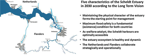
The River Scheldt passes from France through Belgium before entering the Netherlands and draining into the North Sea near Vlissingen (). The last 160 km of this transboundary European river are tidal with the Scheldt Estuary serving as a strategically important access route to the harbour of Antwerp. It is also ecologically significant as one of the last remaining large estuaries with a full gradient from fresh to salt water in North Western Europe. However, the Scheldt Estuary has long been a source of conflict between Belgium and the Netherlands (Meijerink, Citation1999; Peeters et al., Citation2007; De Vries, Citation2008; VSNC, Citation2023). In 1585, the Dutch closed the Scheldt to shipping, crippling the upstream port of Antwerp, and diverting the balance of trade to their more northerly ports. The blockade was only lifted more than 200 years later in 1792 when the Netherlands was occupied by the French. However, toll was still charged by the Dutch for shipping passing through the Western Scheldt. Unlimited access was finally granted to ships in 1863 with the signing of an agreement on the Redemption of Scheldt Toll, but this conflict had left an historical blemish on binational relations. By 1906, the issue of dredging by Belgium in Dutch waters was causing tension, and following the Second World War the Technical Scheldt Committee (Technische Schelde Commissie – TSC) was formed in 1948 to oversee and coordinate the management of the estuary. Many bilateral discussions and negotiations followed, mainly concerning dredging or water quality issues, despite the fact that the Netherlands and Belgium share a language and have strong economic and border control ties. Indeed, both were members of the European Economic Community from its formation in 1957, both countries were signatories to the Schengen Agreement in 1985, and both joined the European Union when it was formed in 1993. Despite such far-reaching political and economic agreements, the Scheldt Estuary and access to the harbour of Antwerp remained contentious. In 1995, after particularly troublesome and drawn-out negotiations, a transnational treaty concerning the deepening and widening of the navigation route was finally signed. This agreement aimed to enable Antwerp harbour to accommodate the increase in size of oceangoing vessels. However, as vessel size continued to increase, the deepening was barely completed and the nature compensation measures were not yet executed before the need for further deepening was tabled informally by the Flemish. This led to the instruction in 1998 from the relevant Dutch and Flemish ministers to the TSC to initiate a process to develop a shared framework for longer term strategic decision-making. From 1999 to 2001, breaking with a 300 year tradition of conflict over the Scheldt Estuary, the Dutch and Flemish succeeded in jointly developing a shared LTV (Slinger et al., Citation2007; De Vries, Citation2008; Zanting et al., Citation2002). In this broad policy document (LTV, Citation2001a, Citation2001b) the triple functions of accessibility for shipping, safety from flooding and the ecosystem were emphasized. The shared LTV for the Scheldt Estuary was ratified in the 1st Memorandum of Agreement signed at Kallo in 2001 and later by the 2nd Memorandum of Agreement signed at Vlissingen in 2002 (VSNC, Citation2023).
Figure 1. Map of the Scheldt Estuary with the lower reaches (Bath to Vlissingen) located in the Netherlands and the middle to upper reaches (Antwerp harbour to Gent) located in Flanders, a province of Belgium. The characteristics of the Long Term Vision agreed bilaterally in 2001 are listed.
Since this groundbreaking agreement, many activities oriented to implementing the LTV for the Scheldt Estuary have been undertaken under the auspices of a joint Dutch–Flemish project organization ProSes established by the TSC (Peeters et al., Citation2007). These activities culminated in the signing of the 3rd Memorandum of Agreement in The Hague in 2005 in which a development pathway till 2010 was agreed. A further agreement was signed in 2005 at ministerial level to facilitate joint Flemish–Dutch management of the Scheldt Estuary. This in turn paved the way for the formation of the Flemish–Dutch Scheldt Committee (Vlaams–Nederlands Schelde Commissie – VNSC), which replaced the TSC in 2008. By 2013 the VSNC had established an Agenda for the Future, within the framework of the LTV, yet coherent with the Dutch Delta Programme and the Flemish equivalent termed Flemish Bays (VSNC, Citation2023). This agenda is operative today, giving rise to ongoing collaborative research (e.g., IAHR, Citation2015; VNSC, Citation2019).
The process design for developing the LTV
In 1998 the TSC awarded a two-year contract to Resource Analysis, a research consultancy from Delft, to design and support the LTV development process in the Netherlands and Flanders. The small consultancy company of fewer than 50 people employed policy analysis principles (Enserink et al., Citation2022; Walker, Citation2000) to design and then implement a boundary spanning process by which civil servants and interest groups from both sides of the border could become engaged in structured dialogue on the future of the Scheldt Estuary. Two senior consultants were responsible for the process design. They decided to view the issue more broadly than just the deepening of the estuary to ensure accessibility of large seagoing vessels to the harbour of Antwerp. They considered that the future Scheldt Estuary revolved around three key issues for which knowledge needed to be integrated and consensus achieved:
Accessibility: the current and future accessibility of the harbour of Antwerp given the trend towards larger and larger oceangoing vessels.
Flood safety: ensuring that flood safety standards would be maintained or even improved given the ever present danger of flooding of the low lying hinterland and the flood history of Zeeland.
Nature: maintaining and improving the ecological health of the Scheldt Estuary, particularly as nature compensation for the previous deepening of the Scheldt was still in arrears and taking cognizance of a history of poor water quality immediately downstream of the harbour of Antwerp.
Moreover, they noted that experts and interest groups with opposing views on these issues were in disagreement with each other in both countries. By hypothesizing that nature groups from both sides of the border would be more likely to agree with each other on the future of the Scheldt Estuary than they would be to agree with the flood safety and accessibility lobbies within their own countries, they came to a process design with boundary spanning at its core. They designed a process in which three binational working groups were constituted, one for each of the key issues. Each working group comprised approximately 15 members with as equal representation from the Netherlands and Belgium as possible, was co-chaired by a Dutch and a Flemish official, and was supported by one or two consultants from Resource Analysis. The project management team, who reported directly to the steering group constituted by the TSC, then comprised the co-chairs of each of the three working groups, supplemented by three members from Flemish and Dutch research institutions, two communication specialists and a representative from the province of Zeeland, with the two senior consultants from Resource Analysis functioning as chairperson and secretary. The steering group in turn comprised thirteen high-ranking representatives from relevant Dutch and Flemish ministries and government departments.
But this intricate and thoughtful process design for knowledge production and the associated project organization with its decision-making procedures did not completely solve the problem of how to link the changes associated with the potential further deepening of the Scheldt Estuary with the key issues of accessibility, flood safety and nature. To address this the two senior Resource Analysis consultants formed a morphology cluster (MC) comprising scientific and engineering experts from both the Netherlands and Belgium, supported by a consultant from Resource Analysis. The MC was viewed as supportive and was tasked with supplying the other working groups with the information and model simulations on changes in the morphometry of the estuary that they would need in the LTV development process. The MC did not have the status of a working group and was therefore not represented in the project management team.
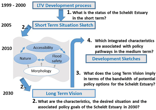
The chief task of the three working groups was then to characterize the desired future state of the Scheldt Estuary in 2030 for their particular issue, namely accessibility, flood safety and nature. To make this possible an innovative integrative four-step visioning process was architected ():
Establishing a short term situation sketch. This was conceptualized as the state of the estuary in 2005 (under the policies operative in 2000).
Envisioning the LTV for the Scheldt Estuary. This was conceptualized as enumerating the accessibility, flood safety and nature characteristics and the underlying morphology of the estuary in 2030, describing the desired state of the Scheldt Estuary in 2030, and specifying the associated policy objectives per key issue.
Determining potential policy options for each of the key issues and the underlying estuary morphology so that the bandwidth for decision-making on the medium term could be understood. The effect of uncertainties and external factors on the policy options were also explored.
Detailing four integrated development sketches for 2010. These are conceptualized as composite outcomes of different sets of policy choices, forming alternative pathways from the short term situation sketch to the LTV. The backcasting and detailing of the integrated development sketches in the medium term served as a check on the feasibility of attaining the LTV.
Figure 2. The process followed in developing the Long Term Vision for the Scheldt Estuary, specifying each of the four steps of the process. The Long Term Vision is characterized in terms of accessibility, flood safety, nature and the morphology of the estuary.
Having determined the steps to take in envisaging the future of the Scheldt Estuary in terms of the three key issues, that is, producing the required knowledge, the responsibility for formulating the potential trade-offs between accessibility, flood safety and nature was placed with the project management team, with the choices on the advice to the TSC for final decision-making on the envisaged future lying with the steering committee. This meant that the responsibilities for achieving knowledge integration and taking decisions were clear and each of the working groups could begin with their task.
The output of the process is encapsulated in two documents (LTV, Citation2001a, Citation2001b). The first document describes the LTV for the Scheldt Estuary in terms of: the process; the short term situation sketch (2005); the characteristics, desired situation and associated policy goals of the LTV (Citation2030); and the integrated development sketches (2010) with associated policy pathways. The five characteristics of the desired situation in 2030 are listed in . The second document explains the process followed more extensively and provides the detailed and integrated background information on which the LTV is based. This is supplemented by a set of digital data on a CD-ROM, known as @l-vis 2.0, containing all LTV documentation as well as maps detailing the short term situation sketch.
Materials and methods
Planning involves a series of steps towards a particular goal and can be understood in terms of three dimensions: the context, the process and the outcomes (Hassenforder et al., Citation2015; McEvoy, Citation2019). In seeking to understand how a transboundary planning agreement was achieved (the process and the outcome), this paper treats the LTV development process on the Scheldt Estuary as the context within which the Nature Working Group (NWG), the flood safety and the accessibility working groups, and the MC were functioning. Months after the start of the LTV process, in February–March 2000, the situation was contentious. Members of the NWG were at odds, with a leading Flemish ecologist threatening to leave the group and so derail the process. The meetings of the MC were also characterized by heated discussions and a wide divergence in opinions on the morphological response of the estuary to channel deepening. Indeed, parallel supplementary investigations on the morphological response of the estuary were initiated separately in the Netherlands and Flanders, indicating that the MC was also experiencing contention. At that time, the author was employed as a senior policy advisor by Resource Analysis, the project bureau designing and facilitating the LTV development process. Owing to her perceived neutrality (she held neither Dutch nor Belgian nationality) and expertise in estuaries (she has a doctorate in estuary modelling and management), the author was tasked with (1) resolving the conflict amongst the ecologists in the NWG, and (2) establishing connections between the ecological and the morphological responses of the estuary to the proposed channel deepening, in support of the overarching transboundary policy process.
A participatory action research approach was adopted as this would facilitate undertaking boundary spanning activities. This commenced with a bilateral discussion between the author and the leading Flemish ecologist at his place of work in which guiding principles for further involvement were agreed. These included that the NWG would speak for the ecosystem and would respect the natural dynamic variation of the Scheldt Estuary. The recognition and articulation of underlying ecological values drew the senior ecologist back into the NWG and paved the way for the full NWG to start to meet again.
In the meetings that followed, the author initiated a group model building process with the whole NWG. Group model building is an intervention methodology aiming to achieve consensus amongst group members on the relevant system elements, their interrelations, and their responses to policy interventions or exogenous influences (Hovmand, Citation2014; Vennix, Citation2000). In this case the group model building was interdisciplinary, yet focused on the ecosystem of the Scheldt Estuary and its potential response to interventions such as channel deepening, sand mining, and depoldering. It was interdisciplinary in the sense that vegetation specialists exchanged knowledge with fish and microbenthic biologists and with water quality and estuarine circulation specialists. A total of three group model building sessions of were held over the following four-month period. Not all NWG members could be present at each session, so each session commenced with a recap of the previous session and an opportunity to comment on the variables and relationships that had been defined. Supplementary consultations were held with the authors of the report on the ecosystem goals (De Deckere & Meire, Citation2000) and with the MC to obtain further information. Finally, validation of the conceptual model occurred within the NWG on 11 September 2000 (Slinger, Citation2000).
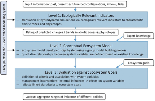
The variables and relationships identified in the group model building were captured in a custom-built modelling package (Van der Werff ten Bosch et al., Citation2000), which was capable of tracing every causal link to ascertain the qualitative effect of a policy intervention on the ecosystem. To deepen the substantive connection between the morphology and ecology, a hybrid three-layer approach (a boundary artefact) was designed by the author to connect existing numerical hydro-morphological model simulations originating from the MC through the ecosystem model to the ecosystem goals and so enable analysis of the effects of different policies on the state of the Scheldt Estuary ecosystem () (Slinger, Citation2000). The hybrid three-layer approach accommodated existing data limitations and issues, namely that no hydrodynamic simulations were available for the entire estuary, although short term morphodynamic simulations were available from the mouth to Antwerp harbour, and that expert opinion would be needed to translate the changes in abiotic conditions into biotic responses.
Figure 3. The integrated three-level hybrid modelling system that translates hydro-morphological simulations via ecologically relevant indicators to characteristic abiotic zones and physiotopes, which are linked through the conceptual ecosystem model at its heart to the ecosystem goals (Slinger, Citation2000).
The contribution of the expert opinion-based ecosystem model, nested within the three-layer hybrid approach, to the achievement of the international agreement on the LTV for the Scheldt Estuary is evaluated retrospectively in terms of its direct contribution to the workgroup processes (boundary procedures), its substantive contribution (boundary artefact) and its effect within the overarching policy process (boundary spanning). Publicly available corroborative evidence is supplied by the final LTV documentation (LTV, Citation2001a, Citation2001b), the report on the coupling between ecology and morphology in the LTV (Slinger, Citation2000), and the international scientific review report (Projectteam LTV, Citation2000).
Formulating the three-layer hybrid system with the ecosystem model at its heart
The first level of the three-level hybrid modelling approach uses morphological simulations of bed topography and associated hydrodynamic responses as input data. These simulations are transformed to ecologically relevant indicators such as the extent of characteristic abiotic (salinity) zones and the areal distribution of subtidal, intertidal and supra-tidal physiotopes within these zones. The utility of the output is dependent on the assumptions made in conducting the simulation runs. In the case of this study, use had to be made of simulations runs of only four-day duration conducted for the purpose of determining sediment transports. The simulation period and the tidal forcing at the downstream boundary therefore were not appropriate to the prediction of the physiotopes and abiotic zones for biota. However, indicative results were obtained, serving to demonstrate clearly the data-processing methods necessary to transform hydro-morphological simulation data into ecologically appropriate indices and establishing working procedures for tracking back and forth between the disciplinary fields of hydro-morphology and ecology.
The next level can be entered from level 1 or independently. This independence means that any data errors or limiting model assumptions need not propagate through the hybrid system, and that the one can proceed based on information or knowledge that may not be able to be simulated by numerical models. Thus, level 2 may be implemented independently of level 1, or value judgements of the ecologically relevant indicator data generated in level 1 may be used as input data for level 2.
Level 2 is a conceptual ecosystem model (an artefact nested within the three-level hybrid approach) consisting of seventeen components with a number of system variables to describe them. Interrelationships between the system variables are specified qualitatively on a seven-point scale which allows their strength and direction to be indicated. This ecosystem model captures the integrated interdisciplinary system understanding of the NWG experts and makes it available to other people involved in the LTV process and beyond. In this sense, it acts as a boundary object within the LTV development process and within the NWG itself.
In level 3, criteria that allow the attainment of the ecosystem goals to be judged are identified and related to the system variables in a structured way. The effects of interventions and relevant exogenous factors are assessed qualitatively by first defining the strength and direction of their effects on individual system variables and then evaluating the results as these effects propagate through the ecosystem. Results are expressed as the range of effects that could possibly occur (from the most negative to the most positive). Most useful at this level of policy evaluation are the insights that can be obtained by comparing interactions to different composite management interventions (see section 5). Second, third and higher level interactions often cause unexpected effects which can be understood by tracing the logical paths. This method of testing and examining the logic behind the outputs exemplifies a process of tracking between disciplinary fields to understand and validate the composite output.
The conceptual ecosystem model
The NWG members considered 17 components fundamental to a description of the ecosystem of the Scheldt Estuary and its past, present and possible future states. These components include the North Sea, freshwater supply, hydrodynamics, morphodynamics, permanently increasing the storage capacity, turbidity, water quality, bed sediment quality, abiotic zones, physiotopes, macrobenthos, fish and prawns/shrimps, birds, marine mammals, primary production, dredging, dumping and sand mining, and ecosystem indicators. Interactions between these components were identified as a first means of discussing the further definition of relevant system variables and their interactions. System variables were then defined per component and the strength of direct relationships between them were assessed qualitatively using a seven-point scale ranging from strongly positive (+++), through positive (++), weakly positive (+), no effect (0), weakly negative (-), negative (–) to strongly negative (—). A strongly positive relationship means that an increase in the system variable exerting the influence leads to a strong increase in the affected system variable. A negative response means that an increase in the influencing variable leads to a decrease in the affected variable. In building the conceptual model each system variable was considered in turn by the group and the direct effects on the other system variables were systematically assessed by qualitatively rating and describing the effect (Slinger, Citation2000). When this integrative analysis had been performed for every system variable, the ecosystem model formulation was cross-checked for consistency and evaluated for completeness. The custom-built Resource Analysis software supported the entry of the interrelationships both graphically and via a table (Van der Werff ten Bosch et al., Citation2000). Although the graphic form was favoured in the interactive group model building sessions, the tabular form was particularly useful for the consistency checking phase.
The ecosystem model for the Scheldt Estuary has 86 system variables and provides a comprehensive qualitative reflection of the response of the Schelde ecosystem to changes in the abiotic state at meso-scale. Specific choices were made regarding the level of biological interaction included in the conceptual model. For instance, the effect of predation by higher trophic levels on lower trophic levels was not included, but the necessity for the presence of the lower trophic levels as food supply was included. This demonstrates the trade-offs in disciplinary accuracy that are made in a boundary spanning activity. Here the ecologists tolerated missing detail for the purpose of achieving a sufficiently representative integrated product. The focus of the biological component of the model is thus on the potential for the occurrence of each of the components (and their system variables), that is, whether or not abiotic conditions and food supplies are favourable and to what degree. The development of this complex model caused a lively and satisfactory exchange of opinions on various occasions, most notably at the validation workshop on 11 September 2000. It was apparent in the formulation of the conceptual ecosystem model that knowledge of how changes within one subsystem (freshwater, brackish and estuarine) would influence another was more limited than knowledge about changes within a subsystem itself. Accordingly the structure of the model is such that it reflects a general conceptualization of the influences of the abiotic environment on biotic components, indicating that tacking back and forth between disciplinary rigour and the requisite detail for a shared, integrated artefact was undertaken. The results obtained when the effects of different combinations of management interventions and exogenous variables are analysed using the conceptual ecosystem model will be described in the results section.
Results of applying the ecosystem model
After formulating the ecosystem model, it was used to analyse the effects of combinations of management interventions and changing external conditions – termed cases. Cases were defined using data supplied by the MC (including channel deepening and effects of sea level rise) and information from the NWG about issues known to be under discussion (e.g., depoldering, nature compensation and river floods). The cases analysed in this study are presented in .
Table 1. Combinations of management interventions and exogenous developments (cases) considered relevant in assessing the response of the natural environment of the Scheldt Estuary.
The range of variation of the system variables in response to these cases was calculated iteratively using simple calculation rules which assume that weak relations tend to die out over time. The results produced include all the possible states of variation. The results can be evaluated and analysed by stepping through the iterations and examining the chain of events in terms of effects on any of the system variables (Slinger, Citation2000). This type of information is useful in tracing counterintuitive results to their source and so increasing the understanding of group members of the complex dynamics of the estuary. Such a process represents a boundary spanning procedure, aimed at achieving integrated understanding and consensus.
The NWG viewed depoldering as a permanent increase in the storage capacity of particular areas of the estuary. Thus, depoldering in the Sea Scheldt (extending from the Gentbrugge sluice to the Dutch–Belgian border – Zeeschelde in Dutch) was interpreted as affecting the storage capacity of the freshwater reaches only, whereas depoldering in the Sea Scheldt and in the Western Scheldt (from the border to the sea – Westerschelde in Dutch) involved permanently increasing storage capacity in the brackish and estuarine reaches as well. This was considered to have the effect of reducing tidal action and the maximum water levels experienced in the brackish region in particular. The consequence is that instead of it only being positive to undertake depoldering in the brackish reaches, there is a strong possibility that the brackish intertidal area may decrease overall. Any effect on the height of inundation will work through to the tidal marsh areas which showed considerable sensitivity to depoldering strategies. The conceptual ecosystem model therefore provides insights into the interrelationships between system variables and the role that these effects have in determining the potential responses of the ecosystem as a whole.
The response of the Scheldt Estuary to the different combinations of management interventions and exogenous influences, as exemplified by the eleven cases, is evaluated in terms of their effects on the ecosystem goals (i.e., on the identified criteria). This means that in practice the evaluation of results is a function falling under level 3 of the three-level hybrid approach, whereas detailed analysis of the causal linkages falls under level 2. Therefore, level 2 is used to elucidate level 3 outcomes highlighting the nested nature of the boundary spanning activities and artefacts in the LTV process.
A comparison of the effects of case 1 with those of case 2 indicated that differences lie in the response of the brackish and estuarine intertidal reaches and also in the response of the marsh vegetation. For instance, the brackish marsh vegetation varies from moderate negative to moderate positive for case 2, whereas the range is from moderate negative to zero for case 1 (). Similarly, the effect on salt marsh vegetation ranges from weak negative to weak positive for case 2, compared with a weak negative effect for case 1. These effects are to be anticipated, because case 1 does not increase the intertidal area in the brackish or estuarine reaches. There are no other significant differences, so for the purposes of further evaluation, case 1 will be used as the most likely depoldering scenario. The conservative dredging, dumping and sand mining strategy represented an extrapolation of the existing policy and demonstrated that these activities exercise moderate to weak detrimental effects on morphological diversity. The consequences for the ecosystem are also moderate negative, primarily for the vegetation, diadromous fish and also estuarine residents. In contrast, the effects of deepening of the channel to 14 m have a potentially strong negative effect on estuarine marsh vegetation and diadromous (and estuarine) fish. These negative effects originate primarily from the dredging, dumping and sand mining activities associated with the channel deepening. However, the possibility of a moderate positive response of these system variables was also indicated. This arose because of the increased tidal variation and upstream extension of the estuarine and brackish zones. These effects could increase the area available for colonization by marsh vegetation and the zones favourable to fish. Determination of which of these influences would occur is dependent on the expected increase in tidal variation and abiotic zones both of which could be accurately predicted using hydrodynamic modelling techniques. However, such ecologically relevant modelling simulations were not undertaken within the LTV development process (see Slinger, Citation2000, for further information on these constraints). Instead, using the conceptual Ecosystem Model allowed the potential range of response (and potential positive and negative consequences) to be explored at relatively low cost.
Table 2. Aggregated range within which the criteria vary until the seventh iteration (no further changes occur thereafter) for 11 cases. .
The differences in the range of response to case 4, channel deepening, and case 5, channel deepening and depoldering in the Sea Scheldt, are indicated by italics in . Most effects were directly ascribable to the combined influence of the two interventions, namely depoldering (cf. case 1) and channel deepening. Clearly, the effects of channel deepening on the ecosystem are not simply eliminated by providing the estuary with more room. The exact position and extent of the area to be depoldered has to be determined with the desired effects on the ecosystem in mind. Issues such as the reduction in tidal variation associated with depoldering and the anticipated increase in tidal variation as a result of channel deepening must be considered in the final decision-making. The possibility of undertaking depoldering and channel deepening in such a way as to cause positive influences on the ecosystem is potentially indicated.
The effects of improving the quality of the freshwater flowing into the Scheldt Estuary, that is, case 6, are indicated in . The freshwater and brackish water quality improves with the degree of improvement in the range weak to strong and the brackish water turbidity declines. The degree of improvement is influenced by the water quality of the bed sediment. The silicon limitation in the mouth reaches exhibits a range from zero to moderate negative, that is, there is the potential for improvement in the effects of the Scheldt Estuary on the North Sea. The degree of improvement depends primarily on the degree to which the water quality improvements in the upper reaches work through to the lower estuarine reaches. The biological responses as captured in the criteria diadromous fish and complete food web range from weak negative to strong or moderately positive, respectively. The negative response arises within the model, because the reduced turbidity means that the nursery function of the estuary for fish cannot be fulfilled as effectively. This also raises a controversial issue discussed during the validation workshop as to whether adult fish are affected negatively by turbidity. This viewpoint was taken in the derivation of the ecosystem goals (De Deckere & Meire, Citation2000), but was not included in the review of the model at the validation workshop. Clarification on this issue needs to be sought before final conclusions can be drawn from the model output. Should the relationships affecting diadromous fish remain as they are at present in the model, then case 6, improving the quality of the freshwater supply, will provide a good example of a management measure that exercises a clear, positive effect on the estuary in general yet can still have unexpected slight detrimental consequences to biota, for example, diadromous fish. It is then the task of the ecologists to clarify the likelihood of occurrence of this possible negative consequence, its severity relative to the potential positive consequences and to indicate whether measures should be taken concurrently with the actions proposed in the case to ensure that only the beneficial consequences occur.
Another case beneficial to the natural environment of the estuary in general is that of nature compensation (case 7). This policy involves creating intertidal physiotopes in the brackish and freshwater reaches. The influences on the criteria are in the range weak to moderate positive, apart from the complete food web which ranges from zero to moderate positive. This is an artefact of the weak positive responses of many food web components, which then fade out according to the rapid assessment methodology computational rules. The effect on the ecosystem of a river flood (an exogenous influence) is considered next (case 8 in ). The only unaffected criteria are the morphological diversity of the Western Scheldt-west and the mouth and the estuarine turbidity. In general, the influence of the flood is equivocal. The increased freshwater supply exercises a favourable effect on the ecosystem, but the higher water levels and stronger currents are not beneficial. Consequently, each of the variables affected exhibits a wide range of variation. The effect on the Scheldt ecosystem of sea level rise is investigated next (case 9 in ). The only potential negative effect of a moderate sea level rise on the criteria occurred for the freshwater marsh vegetation. However, the effect of a strong sea level rise is very different. Potential weak negative consequences are then indicated for the morphological diversity throughout the estuary and the slope of the tidal flats in the Western Scheldt-east and -west is predicted to possibly increase moderately. The turbidity in the fresh and brackish zones could increase slightly owing to increased water levels and current speeds. The extent of the freshwater zone may decrease weakly and the brackish zone increase moderately. All freshwater physiotopes may decrease in areal extent and the consequences for the freshwater biota are moderate negative. However, at the turn of the century the anticipated sea level rise for the Scheldt Estuary was moderate and so case 9 was selected for presentation. Combinations of exogenous influences and management strategies/interventions were considered next. These include the effects of moderate sea level rise when the channel is deepened to 14 m (case 10 in ) and the effects of moderate sea level rise, channel deepening and depoldering in the freshwater zone (case 11 in ). The differences in the output for cases 11 and 10 are indicated in italics. The effects of sea level rise and channel deepening are ambivalent and the margins of variation in the output are wide. The effect on the morphological diversity of the system can be strongly negative to moderately positive, whereas a moderate sea level rise was deemed to have no significant effect on morphological diversity. It is the combination of effects which gives rise to the level of uncertainty indicated in these results. The brackish and estuarine turbidities are likely to increase, but the response of the ecosystem exhibits a wide range of possibilities. In this way, although causal relationships between system variables in the conceptual ecosystem model have been defined (and agreed), the model is reflecting a high degree of uncertainty in the response to be expected under conditions of channel deepening and sea level rise. The output from case 11 concurs with that of case 10 except where indicated in italics (). These effects are easily explained as the influences of depoldering by comparing the output with that of case 5 (channel deepening and depoldering). Depoldering increases the potential for improving the water quality of the freshwater and brackish reaches and for reducing the negative influence of the Scheldt Estuary water quality on the North Sea (reduced silicon limitation). Additionally, depoldering acts to increase the freshwater intertidal physiotope which channel deepening and sea level rise tend to reduce. Thus, the potential negative effects on freshwater and brackish marsh may be able to be compensated by depoldering.
In summary, the ecosystem model (a boundary artefact) can qualitatively simulate the effects of management interventions and their robustness to exogenous variations (levels 2 and 3), facilitating decision-making procedures whether realistic and relevant abiotic simulations are undertaken or not. Moreover, an assessment of the change in an ecologically relevant indicator derived from a hydro-morphological simulation (e.g., a change in areal extent) can be included as an effect in the ecosystem model (as a rating on the seven-point scale from strong negative through to strong positive) and the ecosystem response can then be evaluated in terms of the ecosystem goals. This represents the full implementation of the integrated three-level hybrid approach by linking morphology and ecology to obtain policy-relevant qualitative responses and can be viewed as a nested set of boundary spanning procedures and artefacts.
Conclusions
The ability of the three-level hybrid approach, with the conceptual ecosystem model at its core (nested artefacts), to connect human-induced changes in the morphology to policy-relevant responses in the estuary acted to reassure those involved in the LTV process. The model artefact and associated analysis procedures were seen as the result of a (boundary spanning) group process (that of the NWG). The interactions with the morphology group and those responsible for determining the ecosystem goals in combination with the validation workshop served to establish wider validity, for example, with the MC and other working group members (procedural boundary spanning). We can therefore conclude that the two-fold assignment of (1) supporting communication and (2) establishing a linkage between morphology and ecology was achieved. Stopping here with the analysis, however, would underplay the boundary object effect of the model (the artefact) and the modelling process (the working procedures) – the space that they created for cooperation. The external validity achieved by the boundary object within the LTV process can be ascribed to both the interpretive flexibility of the three-layer hybrid system – it could be subtly different things to different people – and the tracking back and forth that the group model building process required of the NWG members (Starr, Citation2010). They actively, and in some cases unwittingly, built conceptual bridges across the worlds of morphology, ecology, accessibility and flood safety, and deeply integrated across ecological disciplines using metaphors. A shared understanding was developed that it was possible to determine what an intervention such as channel deepening would mean for the ecosystem of the Scheldt Estuary. Most significantly, in building the conceptual ecosystem model, the metaphor of individual personality or intrinsic character was used to describe characteristic interactions in the estuary and the bandwidth within which change would be acceptable for the Scheldt Estuary ecosystem. This metaphorical reasoning (Schlesinger & Lau, Citation2000) was also employed by the NWG in linking the limited numerical simulation data that was available (four-day morphological simulations) to quantified changes in abiotic zones (e.g., brackish zone) and physiotopes (e.g., intertidal habitat) and then through the ecosystem model to the ecological goals for the estuary. Outputs from this three-layer hybrid model application were interpreted in relation to the changes in the intrinsic character of the estuary. The model-based descriptor of the ‘meandering upper reaches’ arose from such discussions and parallels the ‘multi-channel system’ as descriptor of the lower reaches. The latter derives primarily from the morphologists as a boundary spanning outcome to bridge differences in interpretation of the findings from the parallel, supplementary studies undertaken in Flanders and the Netherlands, but was affirmed by the boundary work of the NWG. These metaphors remain in use today (VNSC, Citation2019).
An international scientific review committee affirmed that the three-level hybrid system (a boundary artefact), with the conceptual ecosystem model at its core (a nested artefact), delivered usable outputs at an appropriate scale for integrating ecological and morphological knowledge on the Scheldt Estuary (boundary spanning procedures; Projectteam LTV, Citation2000). Indeed the group model building was effective in synthesizing the knowledge of the ecologists into a coherent and useful boundary spanning predictive tool. Differences of opinion regarding the severity of a causal effect were resolved by exploring the differences that different scores had on the final model outputs. For instance, the divergence of opinions on the effects of improved water quality on diadromous fish was retained as an uncertainty requiring further study. Uncertainties regarding effects were also noted and future research recommended, for example, quantification of the extent to which depoldering in the Western Scheldt would positively influence flooding safety. The boundary activity embodied in the group model building process was effective in addressing the contention between ecologists and preventing the derailment of the overarching LTV policy process. Instead of the NWG threatening to fall apart, it became a working group that was able to agree on the requirements for ecosystem health of the natural environment of the Scheldt Estuary and the associated potential policy pathways. In this sense the precept underlying the design of the LTV policy process was affirmed that ecologists on both sides of the border were more likely to agree than disagree and more likely to agree with each other than with specialists on accessibility or flood safety.
As the only component of the LTV development classified as an integration activity (LTV, Citation2001b, p. 93), this untold story affirms the critical role that data, models and knowledge integration activities can play in achieving transnational agreements on water management.
But, how generalizable are the findings and the boundary spanning knowledge integration approach? In seeking to draw lessons from this single deep case study, attention is drawn to the design of boundary spanning activities at multiple levels. First, in the process design where responsibilities for boundary spanning decision-making and knowledge integration were clearly specified and where Flemish and Dutch participants were required to work together at multiple levels throughout the project organization. Second, in the choice for a participatory action research approach to resolve contention in the NWG, that then focussed on constructing an integrated knowledge artefact (the three-level hybrid approach) supported by boundary spanning working procedures. Third, in the choice for a group model building process and the artefact it would produce. Overall, this consistent and thoughtful approach placed boundary spanning at the heart of the transboundary water management issue. This choice is generalizable to other transboundary situations as we know that knowledge integration is a core challenge.
The ecosystem model itself and the details of the envisaged response to interventions may be applicable to other tidally dominated estuaries, for example, the Eems-Dollard or the Seine, but the generalizability to all estuaries is limited. The choice for group model building and causal loop analysis is more generalizable and the approach could be applied to other complex, multi-actor situations (Enserink et al., Citation2022; Vennix, Citation2000).
It is unclear whether the use of metaphors by the NWG and the MC and their adoption in the LTV documentation is generalizable. The literature on policy framing and some studies on strategic decision-making and storytelling suggest that such approaches are powerful in conveying messages and achieving consensus (Bontje, Citation2017; Dewulf et al., Citation2009; van Oudenhoven et al., Citation2018). However, this case study can only serve as an example where a shared metaphor was helpful for two countries showing language and economic similarities, but can offer no definitive insight in this regard. Further research on the role that metaphors and narrative constructs can play in achieving transboundary water management is advocated, perhaps in countries with less similar economic situations and more complex upstream–downstream spatial relations (cf. Song & Whittington, Citation2004).
Acknowledgements
The members of the Nature Working Group (NWG) and colleagues at Resource Analysis are acknowledged.
Disclosure statement
No potential conflict of interest was reported by the author.
Data availability statement
Supplementary data on the meetings of the NWG are available from the author upon substantiated and reasonable request as they contain personal information and would have to be individually redacted.
Additional information
Funding
References
- Aukes, E., Bontje, L., & Slinger, J. (2020). Narrative and frame analysis: Disentangling and refining two close relatives by means of a large infrastructural technology case. Forum Qualitative Sozialforschung/Forum: Qualitative Social Research, 21(2), Art. 28. https://doi.org/10.17169/fqs-21.2.3422.FQS
- Aukes, E., Lulofs, K., & Bressers, H. (2017). Framing mechanisms: The interpretive policy entrepreneur’s toolbox. Critical Policy Studies, 12(4), 406–427. https://doi.org/10.1080/19460171.2017.1314219
- Barnes, L., & Hicks, T. (2021). Are policy analogies persuasive? The household budget analogy and public support for austerity. British Journal of Political Science, 2021, 1–19. https://doi.org/10.1017/S0007123421000119
- Battistello Espindola, I., & Costa Ribeiro, W. (2020). Transboundary waters, conflicts and international cooperation – Examples of the La Plata basin. Water International, 45(4), 1–18. https://doi.org/10.1080/02508060.2020.1734756
- Bontje, L. (2017). Narrative perspectives on the development of coastal pilot projects [PhD, Environmental Policy]. Delft University of Technology. https://doi.org/10.4233/uuid:8fcebd18-5bd0-4b81-9358-147d7963d1c6.
- De Deckere, E., & Meire, P. (2000). De ontwikkeling van een streefbeeld voor het Scheldeestuarium op basis van ecosysteemfuncties, benaderd vanuit de functie natuurlijkheid (in Dutch). Antwerp University.
- De Vries, J. (2008). Breaking the deadlock: Lessons from cross-border spatial projects in Flanders and the Netherlands. disP – The Planning Review, 44(172), 48–61. https://doi.org/10.1080/02513625.2008.10557002
- Dewulf, A., Gray, B., Putnam, L., Lewicki, R., Aarts, N., Bouwen, R., & van Woerkum, C. (2009). Disentangling approaches to framing in conflict and negotiation research: A meta-paradigmatic perspective. Human Relations, 62(2), 155–193. https://doi.org/10.1177/0018726708100356
- Enserink, B., Abazeed, A., Elhatow, L., & Muricho Onencan, A. (2023). Nile basin land and water acquisition research agenda: A policy brief. International Journal of Water Governance (IJWG 2.0), 9, 47–58. https://doi.org/10.25609/ijwg.9.2022.6876
- Enserink, B., Bots, P., van Daalen, C., Hermans, L., Kortmann, R., Kwakkel, J., Ruijgh-van der Ploeg, T., Slinger, J., Koppejan, J., & Thissen, W. (2022). Policy analysis of multi-actor systems (2nd ed.). TU Delft Open. https://doi.org/10.5074/T.2022.004
- Hassenforder, E., Smajgl, A., & Ward, J. (2015). Towards understanding participatory processes: Framework, application and results. Journal of Environmental Management, 157, 84–95. https://doi.org/10.1016/j.jenvman.2015.04.012
- Hovmand, P. (2014). Chapter 2. Group Model Building and community-based system dynamics process. In Community-based system dynamics (pp.17–30). Springer. https://doi.org/10.1007/978-1-4614-8763-0
- IAHR. (2015 June 28–July 3). Scheldt Estuary physics and integrated management. Special Session. In E-proceedings of the 36th IAHR World Congress (p. 110). https://www.vliz.be/imisdocs/publications/ocrd/273533.pdf.
- Kipyegon Bosuben, D., Wehn, U., & van der Zaag, P. (2022). Lake Victoria water levels declining (2000–2006): The role of absent and uncertain data in a transboundary water controversy. Water International, (2023), 1–13. https://doi.org/10.1080/02508060.2022.2128299
- Lau, R. R., & Schlesinger, M. (2005). Policy frames, metaphorical reasoning, and support for public policies. Political Psychology, 26(1), 77–114. https://doi.org/10.1111/j.1467-9221.2005.00410.x
- LTV. (2001a). Langetermijnvisie Schelde-estuarium (in Dutch). Dutch Ministry of Transport, Public Works and Water Management. Directorate Zeeland.
- LTV. (2001b). Toelichting bij de Langetermijnvisie Schelde-estuarium (in Dutch). Dutch Ministry of Transport, Public Works and Water Management. Directorate Zeeland.
- McEvoy, S. (2019). Planning support tools in urban adaptation practice [Doctoral dissertation]. Delft University of Technology. https://doi.org/10.4233/uuid:48b7649c-5062-4c97-bba7-970fc92d7bbf.
- Meijerink, S. V. (1999). Conflict and cooperation on the Scheldt River basin. A case study of decision making on international Scheldt issues between 1967 and 1997. Environment and Policy Book Series 17. Springer Dordrecht.
- Mukuyu, P., Lautze, J., Rieu-Clarke, A., Saruchera, D., & McCartney, M. (2023). Do needs motivate the exchange of data in transboundary waters? Insights from Africa’s shared basins. Water International, 1–27. https://doi.org/10.1080/02508060.2023.2177075
- Peeters, H., van Hove, B., Verhallen, A., & Cofino, W. (2007). The Scheldt Estuary case: From conflict to cooperation. In Environmental risk management in large river basins: Overview of current practices in the EU and Russia (pp. 95–100). CABRI-Volga Project Deliverable D3, Nizhny Novgorod State University of Architecture and Civil Engineering. http://www.cabri-volga.org/DOC/CABRI-VolgaDeliverableD3
- Petersen-Perlman, J. D., Veilleux, J. C., Aaron, T., & Wolf, A. T. (2017). International water conflict and cooperation: Challenges and opportunities. Water International, 42(2), 105–120. https://doi.org/10.1080/02508060.2017.1276041
- Plengsaeng, B., Wehn, U., & van der Zaag, P. (2014). Datasharing bottlenecks in transboundary integrated water resources management: A case study of the Mekong River Commission’s procedures for data sharing in the Thai context. Water International, 39(7), 933–951. https://doi.org/10.1080/02508060.2015.981783
- Projectteam LTV. (2000). Samenvattingen onderzoeken, audit en second opinions morfologie, natuurlijkheid, toegankelijkheid en veiligheid Langertermijnvisie Schelde-estuarium (Report RA/00-441A), Resource Analysis.
- Sandercock, L. (2003). Out of the closet: The importance of stories and storytelling in planning practice. Planning Theory & Practice, 4(1), 11–28. https://doi.org/10.1080/1464935032000057209
- Schlesinger, M., & Lau, R. L. (2000). The meaning and measure of policy metaphors. American Political Science Review, 94(3), 611–626. https://doi.org/10.2307/2585834
- Slinger, J. H. (2000). The link between morphology and ecology in the Long Term Vision for the Schelde Estuary. A conceptual framework and preliminary results (Resource Analysis Report RA/00-430).
- Slinger, J. H., Hilders, M., & Juizo, D. (2010). The practice of transboundary decision making on the Incomati River: Elucidating underlying factors and their implications for institutional design. Ecology and Society, 15(1), 1. http://www.ecologyandsociety.org/vol15/iss1/art1/.
- Slinger, J. H., Muller, M., & Hendriks, M. (2007). Exploring local knowledge of the flooding risk of the Scheldt Estuary. Water Science & Technology, 56(4), 79–86. https://doi.org/10.2166/wst.2007.539
- Song, J., & Whittington, D. (2004). Why have some countries on international rivers been successful negotiating treaties? A global perspective. Water Resources Research, 40(5), W05S06. https://doi.org/10.1029/2003WR002536
- Starr, S. L. (2010). This is not a boundary-object. Reflections on the origin of the concept. Science, Technology, & Human Values, 35(5), 601–617. https://doi.org/10.1177/0162243910377624
- Starr, S. L., & Griesemer, J. (1989). Institutional ecology, ‘translations’, and boundary objects: Amateurs and professionals on Berkeley’s museum of vertebrate zoology. Social Studies of Science, 19(3), 387–420. https://doi.org/10.1177/030631289019003001
- Van der Werff ten Bosch, J., Kobes, H., Reijngoud, T., & van de Ven, K. (2000). Beleidswizard (in Dutch). LWI Estuaria & Kusten, October 1999.
- van Oudenhoven, A., Aukes, E., Bontje, L., Vikolainen, V., van Bodegom, P., & Slinger, J. (2018). ‘Mind the Gap’ between ecosystem services classification and strategic decision making. Ecosystem Services, 33, 77–88. https://doi.org/10.1016/j.ecoser.2018.09.003
- Vennix, J. (2000). Group model building – Tackling messy problems. System Dynamics Review, 15(4), 379–401. https://doi.org/10.1002/(SICI)1099-1727(199924)15:4<379::AID-SDR179>3.0.CO;2-E
- VNSC. (2019, April). Systeemanalyse natuur Schelde-estuarium. Gezamenlijk feitenonderzoek van stakeholders, deskundigen en de Vlaams-Nederlandse Scheldecommissie (in Dutch). Implementing Measures for Sustainable Estuaries (IMMERSE), Interreg North Sea region. https://northsearegion.eu/media/14997/ltp-n-systeemanalyse-natuur-schelde-estuarium.pdf
- VSNC. (2023). Vlaams-Nederlands Schelde Commissie (in Dutch). Retrieved April 2, 2023, from https://vnsc.eu/
- Walker, W. E. (2000). Policy analysis: A systematic approach to supporting policymaking in the public sector. Journal of Multi-Criteria Decision Analysis, 9(1–3), 11–27. https://doi.org/10.1002/1099-1360(200001/05)9:1/3<1::AID-MCDA264>3.0.CO;2-3
- Wolf, A. T., Yoffe, S. B., & Giordano, M. (2003). International waters: Identifying basins at risk. Water Policy, 5(1), 29–60. https://doi.org/10.2166/wp.2003.0002
- Zanting, H. A., Ten Thij, F., Coosen, J., & Claessens, J. (2002, May). Developing a bilateral long term vision for the Scheldt Estuary. In Proceedings IAIA’02, 22nd Annual Conference of the International Association of Impact Assessment ‘Assessing the Impact of Impact Assessment’.