
ABSTRACT
Following a 2015 Memorandum of Understanding, efforts began to develop a transboundary water allocation plan in the Mara River Basin between Kenya and Tanzania. Many lessons were learned along that way, including the importance of involving basin and national water authorities in all phases of data collection, planning and decision-making; understanding existing water management structures to promote communication and cooperation within countries; and using locally collected data whenever possible. Applying these concepts to future efforts can promote, although not ensure, ownership of the process within each country, trust between countries, and productive discussions around transboundary water resources.
Introduction
Water allocation planning is an important tool for ensuring an appropriate distribution of water within a river basin. Water allocation best practices (synthesized in Speed et al., Citation2013) recommend taking into account (1) equity, (2) environmental protection, (3) development priorities, (4) balancing supply and demand, and (5) efficient use of water. It can also be used to better understand current uses and demands of water, as well as to assess possible future uses and demands to gain an insight in how the availability and distribution of water may change with different development scenarios. Additionally, water allocation planning is important in transboundary river basins, where water allocation plans are often incorporated into transboundary water management, cooperation and/or diplomacy efforts (Molnar et al., Citation2017).
Figure 1. Map of the Mara River Basin.
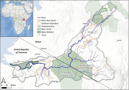
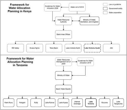
Figure 2. Comparison of the water allocation planning frameworks in Kenya and Tanzania. Note: The relevant basin-scale water management authority for each country is highlighted in bold.
Water allocation plans are data intensive, requiring an interdisciplinary team to understand the supply and demand of water in a river basin. On the supply side, this includes information about how much water is available and how much can be sustainably allocated. On the demand side, information is needed on the types of water users and their expected water demand. A water allocation planning effort should use the best available data on the supply and demand from within the watershed to help understand how this water could be equitably allocated now and in the future.
Although the numerical values stated in a water allocation plan are based on the best available science, the final allocations and the implementation of these allocations are an inherently political endeavour (OECD Studies on Water, Citation2015). While the scientific process helps understand the possibilities, it is the political process that determines the final allocations that will ensure that basic human needs, environmental requirements, and economic goals are met. Creating a transboundary water allocation plan adds another layer of complexity on top of the political process, reinforcing the importance of establishing structured government-to-government communication, designing complementary planning processes, and having the support of regional authorities. As such, the data used to develop water allocation plans are just one aspect of a complicated process for countries to develop and accept transboundary water allocation plans. However, using data all parties can agree upon can create a strong foundation for these other aspects to build upon.
This technical note aims to share lessons learned from transboundary water allocation efforts made in the Mara River Basin in Kenya and Tanzania (). This includes the advantages of using data collection activities to build ownership of the process within each country and to facilitate trust between countries, but also its limitations as approval procedures move up through the levels of government and enter the political arena. While this technical note is not claiming to address all issues around transboundary water allocation, the intent is to provide insight to practitioners who hope to implement water allocation planning in other transboundary river basins.
The Mara River Basin
The Mara River flows 395 km from its headwaters in the Mau Forest of Kenya to its terminus in Lake Victoria, Tanzania (). The Mara River Basin is approximately 13,504 km2, with the upper 65% of the catchment in Kenya and the lower 35% of the catchment in Tanzania. The Mara River is considered one of the most important rivers in the region for conservation since it supports terrestrial and aquatic wildlife populations in both the Maasai Mara National Reserve in Kenya and Serengeti National Park in Tanzania (Pringle et al., Citation2020). The basin also contains significant livestock and animal husbandry activities, small- and large-scale agriculture with a high potential for irrigation, rapidly growing artisanal and commercial mining activities, and a strong tourism industry with significant economic value, all of which require freshwater resources (LVBC & WWF-ESARPO, Citation2019; NBI, Citation2020).
Frameworks for water allocation
In Kenya and Tanzania, the requirement for water allocation planning is similar in their language, but different in how they are structured and implemented (). In Kenya, the framework for water allocation planning comes from the Water Act of 2016, building on the Water Act of 2002, and the Guidelines for Water Allocation, which were developed in 2009 (Republic of Kenya, Citation2016; WRMA, Citation2009). Under the Water Act, the Ministry of Water, Sanitation, and Irrigation is responsible for developing water policy, while the Water Resource Authority is responsible for implementing those policies. Under the Water Resources Authority, six basin area offices oversee developing integrated water resource management and development plans and water allocation plans, among other duties. The Water Resources Authority is a state corporation owned by the government, but is not a governmental agency. This often makes communication and collaboration between the two entities less direct and more formal in nature. The Ministry of Water, Sanitation, and Irrigation also oversees all transboundary water efforts, so any transboundary management plans must be approved by the ministry.
In Tanzania, the framework for water allocation planning is through the Water Resources Management Act of 2009 and Guidelines for Water Allocation Planning, which were approved and adopted in 2018 (URT, Citation2009, Citation2018). Under the 2009 Act, the Ministry of Water is responsible for all domestic and transboundary water management, including developing water allocation plans. Within the Ministry of Water, there are nine basin water boards that carry out planning, permitting, monitoring and enforcement activities at the river basin scale. Approval for any planning activity is done by the basin water boards and approved by the Ministry of Water. Since both the Ministry of Water and the basin water boards are government entities, communication and collaboration between the two is more straightforward.
Kenya and Tanzania also signed the Memorandum of Understanding (MoU) on the Joint Water Resources Management of Trans Boundary Mara River Basin in 2015 (URT & Republic of Kenya, Citation2015). This was signed with the support of the Lake Victoria Basin Commission (LVBC), which is a specialized institution of the East African Community. Through this MoU, both countries agreed to initiate a detailed water allocation planning process in the Mara River Basin. This includes the development of a transboundary water allocation plan and a joint water management plan. This MoU also established a joint steering committee (comprised of permanent or principal secretaries of various ministries in both countries to provide policy guidelines and ensure cooperation at the highest levels of government), a joint technical committee (comprised of directors or senior officials from various ministries in both countries to gather and share data across boarders), and a joint implementing committee (comprised of officers from various ministries in both countries to develop and implement the water resources management plans). While some external water allocation planning efforts had already been completed (GLOWS-FIU, Citation2011, Citation2012; Dessu et al., Citation2014; LVBC, Citation2013; LVBC & WWF-ESARPO, Citation2010), a coordinated effort with the countries and international partners started after the 2015 MoU was signed, with data collection efforts in Kenya beginning in 2015 and in Tanzania in 2019.
Methodology
The water laws in both countries require the development of water allocation plans in all major river basins. Both water allocation guidelines use the concept of a water balance to drive allocation decisions. While the guidelines are independent and comprehensive, the shared foundation is the following water balance equation, which can be found in the water allocation planning guidelines of both countries (URT, Citation2018; WRMA, Citation2009):
Water balance = Available water – (reserve + transfers + water allocations).
The available water is the estimate of usable water from all freshwater sources: rainfall, rivers, lakes, and groundwater.
The reserve is the combination of water for basic human needs and ecological requirements (which has the highest priority in Kenya and Tanzania).
The transfer of water, which includes international agreements and inter-basin transfers.
The remaining water allocations are based on current and future water demand by sector (such as agriculture, livestock, energy, industry, tourism, etc.) and are allocated and enforced through water permits.
If the water balance is positive, it indicates there is enough water to meet all approved allocations. If it is negative, it is a sign that there is insufficient water to meet all allocations and some allocations will need to be adjusted. To understand seasonal and spatial changes in the water supply and demand throughout the year, this calculation was done on a monthly basis and by subbasin. More details on the approach can be found in the water allocation guidelines (URT, Citation2018; WRMA, Citation2009) and the Water Allocation Plan for the Mara River Catchment, Tanzania (URT, Citation2020).
Data collection activities conducted
Since the foundation for the water balance is the same in both countries, the same methodologies for quantifying water availability, the reserve, water demand and water allocation were used in both countries. Water allocation studies were carried out to gather detailed data on water availability, current water abstractions, future water demands and environmental flows.
These studies occurred in two main phases: the first phase took place on the Kenyan side of the Mara River Basin between 2015 and 2018, and the second phase took place on Tanzanian side of the Mara River Basin in 2019 and 2020.
During this time, a variety of activities were completed on both sides, including the following:
Analysing available discharge data, repairing discharge monitoring stations and updating quality assessment control processes.
Completing an environmental flow assessment using a modified building block methodology (King et al., Citation2008), which included hydrologic, hydraulic, ecological and social assessments at multiple study sites.
A field-based water abstraction survey of water users and approximate usage amounts.
A water demand assessment using population, industry, commercial, tourism and wildlife data, as well as planning documents for expected future developments.
A water resources assessment and a water evaluation and planning (WEAP) model for the entire Mara River Basin to better understand hydrological processes and future scenarios.
A series of workshops on robust decision support on various development scenarios and water security.
Various technical meetings with staff and consultants, as well as stakeholder meetings for the public.
To the greatest extent possible, only data collected within the basin were used and models using data from external sources were not incorporated. The hydrological data came from monitoring sites established and operated by government entities, which also collected and managed the data and shared them with project partners. These data formed the basis for the regionalization outputs developed in ungauged subbasins as part of the hydrological analysis.
The outputs from these activities allowed for the calculation of the water balance. Water availability came from the water resources assessment (which included in-situ flow and rainfall data and openly available remote sensing data) and the WEAP model; the reserve, which was calculated by combining the amount required for basic human needs (25 L/person/day) with flow recommendations from the environmental flow assessment; existing international agreements or inter-basin transfers (there is none for the Mara River so this value was zero); and water allocations coming from the demand assessment.
Results
The approach for creating a transboundary water allocation plan in the Mara River Basin involved two stages. The first stage was to complete a country-specific water allocation plan for each side of the Mara River Basin and gain approval from that country’s Ministry of Water. The second stage was intended to harmonize the two plans into one cohesive plan for approval from both countries and the LVBC.
At the beginning of the effort in each country, a large stakeholder meeting was held which included members of the Ministry of Water from each country, staff from the basin water authorities, members of the LVBC (representing the East African Community), international donors, national and international non-governmental organisations (NGOs), as well as other important local stakeholders.
Data collection and analysis efforts were done in a collaborative manner, with national and international partners providing technical guidance on hydrological assessment, environmental flows and water allocation planning. The authorities at the basin level were the Lake Victoria South Basin Area Office in Kenya (which was known as the Lake Victoria South Catchment Authority at the time of the fieldwork) and the Lake Victoria Basin Water Board in Tanzania. These basin authorities provided basin-specific and institutional knowledge of the hydrological, ecological and social conditions of the area. To the greatest extent possible, the goal was to include these basin authorities in the development and implementation of each activity. The exception to this was the building of the WEAP model, where international technical advisors did this activity separately, explaining the process afterwards to the water board staff. However, the input data used were the same as those collected and analysed by the basin authorities, enabling trust in the outputs of those model even if they were not directly involved in their development.
As much as possible, the same technical experts were involved in both countries to maintain consistency between the assessments. In addition, staff members of the basin authority from the other country were invited to field campaigns to improve their understanding of the entire basin: members of the Lake Victoria Basin Water Board were invited to attend some data collection activities in Kenya, while members of the Lake Victoria South Basin Area Office were invited to Tanzania to do the same. The intent of these exchanges was to promote cooperation, demonstrate transparency between water authorities in the two countries, and ultimately to build trust in the data and the process on both sides of the basin.
While the collaboration with the basin authorities was similar in each country, the involvement of the ministry in each country was different. In Kenya, the data collection activities were completed with the Lake Victoria South Basin Area Office. The Ministry of Water, Sanitation, and Irrigation in Kenya was invited to participate and was provided with regular updates, but was not involved in the data collection activities. The water allocation plan was written by the Lake Victoria South Basin Area Office and technical advisors, which was then submitted to the Ministry of Water, Sanitation, and Irrigation for approval.
In Tanzania, all water allocation planning efforts were completed with the Lake Victoria Basin Water Board as well as the Ministry of Water, which established a technical team dedicated to the water allocation planning process. While the Lake Victoria Basin Water Board was the lead on all day-to-day activities, the Ministry of Water had representatives involved in each field campaign, technical meeting, and stakeholder meeting. A joint team with members from the Lake Victoria Basin Water Board, the Ministry of Water, and a team of technical advisors drafted the water allocation plan together.
In 2020, the Ministry of Water in Tanzania finalized its water allocation plan for the Tanzanian side of the Mara River Basin and shared the results with stakeholders and the public (URT, Citation2020). While the water allocation plan for Kenya was drafted in 2018, the Kenyan Ministry of Water, Sanitation, and Irrigation has not yet ratified the water allocation plan for the Kenyan side of the Mara River Basin, and it has not been shared publicly as of March 2023.
Further discussions around a transboundary water allocation plan have taken place within the joint committees that were established under the MoU, which were informed by data on international experiences in comparable contexts, but neither a draft nor final plan has been developed.
Discussion
Many factors likely influenced this outcome. The difference in the engagement of the agencies in each country may have had an impact. In Kenya, the water allocation plan was created by the Water Resources Authority (via the Lake Victoria South Basin Area Office), which carried out all the technical and planning activities. The plan was then sent to the Kenyan Ministry of Water, Sanitation, and Irrigation for approval, which was not involved in data collection activities. This division of tasks may have created a gap in trust of the process and of the values developed. While in Tanzania, the Lake Victoria Basin Water Board was the lead author and worked closely with the Tanzanian Ministry of Water in each phase of the effort, allowing for a better understanding of process and how the final values were developed.
Related to this, the structure of the water authorities may have impacted the approval process. The Water Resources Authority in Kenya is a parastatal organization under the Kenyan Ministry of Water, Sanitation, and Irrigation. This means that the Water Resources Authority has mandates from the government but operates as a separate entity from the Kenyan government. In addition, the Water Resources Authority is responsible for water management within the boundaries of Kenya, but transboundary water issues are handled by the Ministry. This separation of entities and responsibilities requires more formal arrangements for communication and cooperation. In Tanzania, the water boards are a government entity contained within the Ministry of Water, which handles both national and transboundary water issues. This structure simplifies communication and coordination as all efforts are carried out by the same entity.
Another issue that may have contributed to a final water allocation not being approved yet is the international dynamic between the two countries. Kenya and Tanzania are often compared as they are the two largest countries in East Africa, and there is a cautious approach to collaboration and sharing information, particularly around sensitive water resources data. In addition, there is a lack of detailed transboundary water policies in both countries, so there are no mutually agreed upon guidelines for data-sharing or completing a transboundary water planning project, nor a recent example to follow.
Potentially due to these sensitivities, when activities first began in Kenya, there was not a consistent effort to include Tanzanian water authorities in the process. During the document review process, there was criticism from the Government of Kenya regarding the lack of an international consultation process with the Tanzania water authorities. Learning from this experience, when the water allocation planning activities were completed on the Tanzanian side, project partners ensured the proper consultation of all critical stakeholders (including colleagues from the Kenyan water authorities) and that the process complied with all international agreements.
During the document review process on the Kenyan side, the Kenyan Ministry of Water also provided critical feedback on the data and the assessment, and therefore on the quality of the water allocation plan. While having the Lake Victoria South Basin Area Office involved in the data collection and analysis activities developed trust within the Water Resources Authority, that trust was not shared by the Ministry, who were not present for these activities. Although all data collection and analysis activities were conducted to international best practice, concerns about the quality of the data, combined with the criticism of the international consultation process, were serious enough to pause the approval process in Kenya.
In Tanzania, extra care was taken to avoid this outcome. National and international project coordinators ensured all parties involved in the process understood how the information in the water allocation plan was calculated. This included having members of the Tanzanian Ministry of Water and other key stakeholders actively participate during data collection activities, engage in technical meetings and lead stakeholder engagement efforts. During these activities, members from both the Lake Victoria Basin Water Board and the Tanzanian Ministry of Water were able to engage with the technical experts to better understand the methodologies applied, the process of data collection and analysis, and the applications (and limitations) of the final outputs of the technical assessments.
All these efforts proved to be critical to the development and approval of the water allocation plan in Tanzania. When the members of the Lake Victoria Basin Water Board and the Ministry of Water began drafting the document, they were able to trust the data and own the decisions they made in the process. This enabled them to complete the document in a relatively short amount of time. In summary, the efforts on the Tanzanian side had the benefit of learning from the process on the Kenyan side, specifically incorporating all levels of water authorities in all project activities and prioritizing transboundary consultation, which resulted in a smoother process overall.
In addition to the country-specific issues addressed above, the joint committees established under the 2015 MoU have struggled to reach full functionality. They meet infrequently, typically at the request of international donors, who also provide financial support to undertake these meetings. As there is no legal obligation to complete a water allocation plan through the MoU, there is no urgency to complete this process and political priorities frequently take precedence over management needs.
One final observation of this process was that the use of hydrological and meteorological data collected by the basin authorities solidified the importance of such networks in water resources analysis and planning. The river discharge data provided by both the Water Resources Authority in Kenya and the Lake Victoria Basin Water Board in Tanzania were not complete records and there were initially some concerns related to data quality (which were subsequently analysed with the technical advisors). However, seeing their data being directly used in decision-making tools was a powerful starting point for building trust in the process itself, and simultaneously showed the importance of maintaining good monitoring networks. This was also reinforced during the exchanges with the field staff, who were able to discuss and compare how data are collected and managed on either side of the basin. Even after the main activities of the water allocation planning process concluded, there are continuing efforts from both governments to continue improving their hydrological and meteorological networks. While this was not the overall goal of the water allocation efforts, it does highlight a lasting effect and encourages both governments to be ready for any updates to the water allocation process in the future.
Conclusions
Transboundary water allocation planning is a challenging, yet critical, process for sustainable and equitable water resources management. It combines scientific data collection and analysis with management decisions and political priorities. While there are a variety of reasons a water allocation plan may not be approved, a lack of trust of the data and outputs by authorities (both within their own country and within neighbouring countries) can be a significant barrier. To prevent this from happening, it is critical that water management authorities and national decision-makers are involved in the process from start to finish. This includes activities such as data collection, analysis, planning, document writing and stakeholder engagement. In this way, all engaged agencies can more fully understand the details of the water allocation planning and have ownership over the process. In addition, understanding and working within national and international water management structures is important to identify the best methods to promote communication and cooperation within countries and across boundaries. And using as much locally collected data as possible shows the importance of maintaining a monitoring network that can provide inputs to water management decisions. Applying these concepts to future efforts can promote ownership of the process, build trust between countries, and enable productive discussions around transboundary water resources.
Disclosure statement
No potential conflict of interest was reported by the authors.
Correction Statement
This article has been corrected with minor changes. These changes do not impact the academic content of the article.
Additional information
Funding
References
- Dessu, S. B., Melesse, A. M., Bhat, M. G., & McClain, M. E. (2014). Assessment of water resources availability and demand in the Mara River Basin. Catena, 115, 104–114. https://doi.org/10.1016/j.catena.2013.11.017
- Global Water for Sustainability Program & Florida International University. (2011). Refining reserve flow recommendations for the Mara River, Kenya and Tanzania. Florida International University, Miami.
- Global Water for Sustainability Program & Florida International University. (2012). Environmental flow recommendations for reserve flows in the Mara River, Kenya and Tanzania. Florida International University, Miami.
- King, J., Tharme, R., & Villiers, M. D. (2008). Environmental flow assessments for rivers: Manual for the building block methodology. Water Research Commission, Gezina South Africa. http://swrcb2.swrcb.ca.gov/waterrights/water_issues/programs/bay_delta/deltaflow/docs/exhibits/swrcb/swrcb_king2008.pdf
- Lake Victoria Basin Commission of the East African Community. (2013). Mara River Basin-Wide Water Allocation Plan. Lake Victoria Basin Commission of the East African Community, Kisumu, Kenya.
- Lake Victoria Basin Commission of the East African Community & WWF Eastern and Southern African Regional Programme Office. (2010). Assessing reserve flows for the Mara River. WWF Eastern and Southern African Regional Programme Office, Nairobi, Kenya.
- Lake Victoria Basin Commission of the East African Community & WWF Eastern and Southern African Regional Programme Office. (2019). Vulnerability and adaptation in the Mara River Basin. WWF Eastern and Southern African Regional Programme Office, Nairobi, Kenya.
- Molnar, K., Cuppari, R., Schmeier, S., & Demuth, S. (2017). Preventing conflicts, fostering cooperation – The many roles of water diplomacy. UNESCO, ICWC and ICWRGC.
- Nile Basin Initiative. (2020). Lower Mara River environmental flow assessment final resource quality objectives and reserve assessment report.
- OECD Studies on Water. (2015). Water resources allocation. Organisation for Economic Co-operation and Development. https://doi.org/10.1787/9789264229631-en
- Pringle, H., Hughes, K., Ojwang, W., Joseph, C., Onyango, K., Kessy, N., & Tickner, D. (2020). Freshwater biodiversity of the Mara river basin of Kenya and Tanzania. WWF-UK. https://wwfke.awsassets.panda.org/downloads/wwf_2020_marafreshwaterbiodiversityreview.pdf
- Republic of Kenya. (2016). The water A, ct2016.
- Speed, R., Yuanyuan, L., Quesne, T. L., Pegram, G., & Zhiwei, Z. (2013). Basin water allocation planning: Principles, procedures and approaches for basin allocation planning. UNESCO.
- United Republic of Tanzania. (2009). Water resources management act, 2009.
- United Republic of Tanzania. (2018). Tanzania guidelines for water allocation planning.
- United Republic of Tanzania. (2020). Water allocation plan for the Mara River Catchment, Tanzania.
- United Republic of Tanzania & Republic of Kenya. (2015). Memorandum of understanding between the government of the Republic of Kenya and the government of the United Republic of Tanzania for joint water resources management of the transboundary Mara River Basin.
- Water Resource Management Authority. (2009). Final water allocation guidelines.