Abstract
The morphological features and physicochemical properties of 14 soil profiles, representing the major soil types, were studied in the Cathedral Peak VI catchment of KwaZulu-Natal, South Africa. The soils are characterised by a high organic carbon content in the topsoil, red and yellow freely drained subsoils, and some signs of water saturation in the deep subsoil and saprolite. The lack of variability in the morphology of the soils is probably a result of deep weathering of the chemically homogeneous basaltic parent material. Shelving controls the development of return flow on the slopes, feeding into the two prominent wetlands. The freely drained nature of the subsoil horizons are reflected in the red colour and low pH values of these horizons. The iron and manganese redoximorphic features, occurring in the lower horizons, are indicative of periodic short periods of water saturation.
Introduction
An understanding of the morphological, physical and chemical properties of soils at a watershed scale is important to construct soil water landscape models for application in hydrological models (Ticehurst et al. 2006). Soil genesis under different environmental conditions contributes to the extreme heterogeneity of the solid phase of soils, thereby creating a unique internal architecture and aggregation for each soil. Because water is in direct contact with the internal soil architecture, one can expect a great variability in soil water behaviour (Kutilek and Nielsen Citation1994). Soil water regime is not only important for determination of the use and productivity of soil but also for hydrological studies in small catchments. In recent times there has been renewed interest in soil water behaviour because of the need to assess and manage the risks of off-site contamination (Diamond and Sills Citation2001). Soil morphological interpretation has been used to relate soil water regime to soil morphological features such as matrix and mottle colour patterns and their distribution within the soil profile (Crown and Hoffman Citation1970, Franzmeier et al. Citation1983, Moore Citation1974, Evans and Franzmeier Citation1988, van Huyssteen and Ellis Citation1997). Ticehurst et al. (2006) successfully used soil morphology (mainly soil colour and redox morphology) to distinguish the main areas of water saturation and potential lateral flow paths down the Billabong Creek catchment hillslope in south-east Australia. Patterns in soil features, such as changes in soil colour, mottling, and iron (Fe) and manganese (Mn) concretions, proved useful in identifying the locations and depths where water saturation and lateral flow are likely to occur.
The objectives of this study were to characterise soils of the Cathedral Peak VI catchment and to relate profile morphology to the soil water regime.
Materials and methods
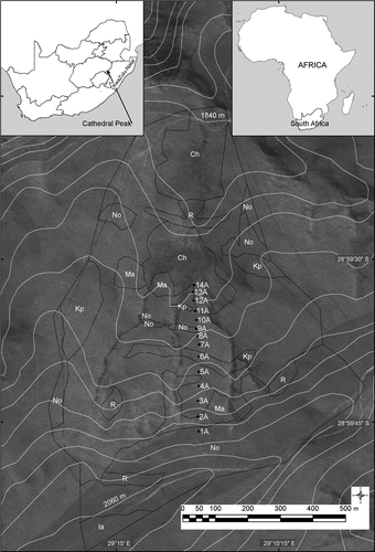
The predominantly north-facing Cathedral Peak VI catchment is situated in the Drakensberg Mountains of KwaZulu-Natal (28°30′ to 30°30′ S, and 28°30′ to 29°30′ E). It forms part of the Cathedral Peak Forestry Research station in a conserved area of the Natal Drakensberg National Park. The catchment is 67.9 ha in extent and is moderately dissected by streams. The elevation ranges from 1 860 m at the weir to 2 070 m at the crest (). The terrain has a slope of 19% grading to 8% at the weir. Two large saturated zones exist in the catchment. The upper zone is located on a topographic convergence midway up the catchment and the other where the stream flattens before the weir and catchment outlet (Everson et al. Citation1998). Rainfall is strongly seasonal, occurring mainly in summer. The mean annual rainfall for 5 years recorded at Cathedral Peak VI catchment is 1 299 mm (Everson et al. Citation1998).
Figure 1: Soil map, location of the profiles, and 20-metre-interval contour lines in the Cathedral Peak VI catchment. Ch = Champagne 1200, Ia = Inanda 1200, Kp = Kranskop 1200, Ma = Magwa 1200, No = Nomanci 1200, R = Rock
Fourteen soil profiles, sited at 10-15 m intervals, were described, classified ( Soil Classification Working Group Citation1991) and sampled (). Soil matrix and mottle colour was determined with a Munsell colour chart (Munsell Color Company Citation1975). Horizon soil samples were air-dried and sieved to remove coarse (>2 mm) fragments. Particle size distribution was determined by sieving and the pipette method, pHwater, pHKCl, dithionite-bicarbonate-citrate (CBD) extractable ‘free’ Fe and Mn, exchangeable cations, cation exchange capacity (CEC) at pH 7, organic carbon, and total nitrogen were determined in accordance with standard methods (Non-Affiliated Soil Analysis Work Committee Citation1990). Bulk density was determined with the core excavation method, using a 50.5 mm radius and 116.5 mm high cylindrical core giving a volume of 933 000 mm3. Average and standard error values are reported in the text.
Results and discussion
The catchment is situated on the elevated plateaus in the hinterland region of the Tugela Basin (van der Eyk et al. Citation1969) in which high rainfall (1 299 mm) and cool temperatures combine with steep to moderate relief (Everson et al. Citation1998). The soils are of residual and colluvial origin and derived from basalt (Everson et al. Citation1998). Because of the high rainfall in the region, the soils are commonly associated with a high degree of weathering and high organic matter content. The soils are therefore normally well drained with a high acidity. The studied soils have little variation in their characteristics (), comprising only humic A and organic O topsoils (Soil Classification Working Group Citation1991).
Five hundred mm deep Nomanci 1200 loam soils occur on the high-lying areas of the catchment, grading into 1 800 mm deep Magwa 1200 clay soils on the upper midslopes ( and , ). The midslope, which forms the greater part of the catchment, is dominated by 1 800 mm deep Inanda 1200 silt loam soils, whereas the footslopes are characterised by 2 300 mm deep Champagne 1200 coarse sandy clay loam soils. The soil drainage classes were deduced from the subsoil colour. The A horizons vary in depth from 150 mm in the upper slopes to 300 mm in the middle of the catchment. The A horizons have a bulk density of 0.70 Mg m-3 and the B horizons a bulk density of 1.00 Mg m-3. The low bulk density provides confirmation of a porous medium contributing to the highly leached nature of the soil. The corresponding porosity values for the A and B horizons are 65.5% and 57.7%, respectively. The B horizons are up to 2 m deep and merge into saprolite in the Kranskop and Inanda soil.
Table 1 : Soil classification (Soil Classification Working Group, Citation1991) and drainage class (Le Roux et al. Citation1999) per terrain morphological unit in the Cathedral Peak VI catchment
Table 2 : Abbreviated morphological description, classification and texture of selected soils in the Cathedral Peak VI catchment
The A horizons are black (10YR 3/3) and attest to the high accumulation of organic matter in these soils (). Clay content increased from 22.3 ± 3.3% to 33.8% ± 1.8 at 1 200 mm and pHwater increased from 4.89 ± 0.05 to 5.24 ± 0.05 at 1 200 mm in most profiles, suggesting that acid weathering (Brahy et al. Citation2000) of clay is the dominant process in the upper horizons. This was expected in this high rainfall area where organic matter accumulation and subsequent high biological activity resulted in a higher H2CO3 concentration and therefore increased weathering of the clay minerals in the humic A horizons. The highest clay contents are found in profile C4A where the clay content increases from 23% at the surface to 62% below 300 mm depth. Soil texture also changes downslope, from dominant clayey in the upper profiles to dominant sandy clay loam in the midslope and dominant clay loam in the lower slope ().
The red and yellow soil colour below the dark surface horizons is indicative of unsaturated, aerobic conditions (van Huyssteen et al. 1997, Le Roux et al. Citation1999, van Huyssteen et al. Citation2007, Citation2010). Most of the subsoil horizons are red, indicating oxidised conditions (). All the profiles had a high CBD-extractable Fe content, reflecting the basalt parent material and advanced weathering. The Fe content increased irregularly with depth in most profiles (), from an average of 65 550 ± 4 562 mg kg-1 at 300 mm to an average of 75 758 ± 5 567 mg kg-1 at 1200 mm. Redox accumulations of Fe and Mn were only identified at a depth of 2 m, mostly in the saprolite (). The saprolite therefore appeared to be moderately drained.
The CBD-extractable Fe content of the horizons varies, but is always extremely high. It increases systematically downwards in profile C5A and decreases systematically downwards in profiles C2A, C7A and C12A (). The Fe content ranged from 34 450 mg kg-1 in the B2 horizons of C13A and C14A to 110 000 mg kg-1 in the B2 horizon of C11A, but tended to increase downslope (). These values are lower than the 250–300 g kg-1 reported by Curi and Franzmeier (Citation1987) for basalt-derived Oxisol in the Central Plateau of Brazil, but still meant that between 3% and 11% of the soil mass consisted of Fe oxides and hydroxides. Yilmaz et al. (Citation2005) reported Fe2O3 values between 0.30% and 1.22% for basalt parent material soils in south-eastern Turkey. The CBD-extractable Mn is generally very low compared to the CBD-extractable Fe. Manganese generally occurs in South African soils in a ratio of 1:10 with Fe (Le Roux Citation1996). The low concentration of Mn relative to Fe (1:546 on average) in these soils indicates Mn removal from the soils under acidic and leaching conditions, because Mn is more soluble (reduces easier) than Fe, especially at a low pH. Manganese contents increases unsystematically downslope in all profiles studied (), supporting this hypothesis. In the Inanda soils, there is an apparent loss of Mn in the B1 horizons and accumulation thereof in the B3 and saprolite horizons, where it is mainly localised into fine to medium black mottles. An increase in Fe and Mn mottle abundance and size generally corresponds to an increase in period of saturation (Vepraskas Citation2001). The absence of grey low chroma colours, required to classify ‘signs of wetness’ (Soil Classification Working Group Citation1991), can be attributed to limited reduction or to a large amount of Fe in the soil, buffering the redox potential. The removal of Fe oxides from the soil particles is therefore not enough to expose the grey-coloured quartz soil particles.
Average organic carbon was high (5.39 ± 0.14% at 300 mm) and decreased with depth to an average of 0.73 ± 0.16% at 1 200 mm in all profiles (). Du Preez et al. (Citation2011) report that 58% of topsoils in South Africa contain less than 0.5% organic carbon and that only 4% contain more than 2% organic carbon. The highest organic carbon content (6.15%) was measured in the topsoil of C10A, whereas the lowest (0.04%) was measured in the saprolite of C7A. The high amounts of organic carbon in these profiles are attributed to the cool wet climate, which produces dense grass vegetation resulting in high organic matter addition to the soil. Microbial decomposition is concurrently retarded by the low temperature and high clay content and bias towards fungi favouring humification instead of mineralisation (Driessen et al. Citation2001). The systematic wavy change of organic carbon in the first and second layers downslope is an indication that the topographical effects of the shelves influence the soil water regime and therefore vegetative growth ().
The cation exchange capacity (CEC) in the profiles and downslope is quite variable with no clear observable trend (). This variation can possibly be attributed to differences in clay mineral type. The average CECclay over all horizons was 86.0 cmolc kg-1 clay, but varied from 35 to 50 cmolc kg-1 clay in the subsoils to 138 cmolc kg-1 clay in the topsoils. The CEC was, however, high (on average 22.6 ± 0.9 cmolc kg-1 soil at 300 mm) in the surface horizons of C3A, C4A, C6A, C8A, C11A and C12A, and then decreased with depth to an average of 13.1 ± 1.8 cmolc kg-1 soil at 1 200 mm. This was probably because of the effect of the higher organic matter content in the surface horizons (Helling et al. Citation1964).
Soil pHwater values increased with depth in nearly all studied soil profiles, from an average of 4.89 ± 0.05 at 300 mm to an average of 5.24 ± 0.05 at 1 200 mm (). The combined impact of basic rock weathering, which tends to keep the pHwater high in the subsoil, and acid weathering, which acidifies the topsoils and spread out downwards, will result in pHwater increasing with depth. This is typical of freely drained, acidic soils (Skyllberg et al. Citation2001, Arbestain et al. Citation2004). The increase in pHwater with depth may further be a sign of ferrolysis. Ferrolysis is the result of alternating reducing conditions, resulting in redoximorphic features, commonly found in these subsoils (Brinkman Citation1979, Le Roux et al. Citation2005). Long durations of water saturation above drained upper limit (Kuenene Citation2007, Kuenene et al. Citation2011) are an indication that reducing conditions occur in these subsoils and consequent oxidation may be responsible for the low subsoil pHwater. Most pHwater values in the upslope soil profiles are below 5.5 and increase to below 6.5 in the lower-lying profiles. This difference in acidity is probably caused by acid weathering and leaching of basic cations from the upslope soils followed by accumulation thereof in the lower-lying soils. The variable pHwater values can also be attributed to differential rates of weathering and soil development in the soils of the catchment.
Conclusions
The soils in the Cathedral Peak VI catchment show little variation along the dominant hillslope. The soil morphology is dominated by high organic carbon content in the topsoil and subsoil. In the subsoil the high Fe content masks the darkening colour of the organic carbon leaving a thin humic A horizon. Basalt, a homogenous parent material, and the cool wet climate are the main factors that govern the soil formation. The major pedogenic processes in the soils of the catchment are humification, acidification, acid weathering and ferrolysis.
The red soil colour and low pH values indicate that water movement is rapid and vertical. It was therefore expected that these soils are freely drained and not water saturated. The presence of Fe and Mn redox accumulations was the only morphological feature that indicated periodic water saturation at the bottom of most profiles. It is expected that the vertical drainage of water is impeded here by the rock and accumulation of water in the saprolite, resulting in the observed redox accumulations.
Acknowledgements
Funding by the Water Research Commission, the National Research Foundation, and the University of the Free State is gratefully acknowledged.
References
- Arbestain , MC , Mourenza , C , Álvarez , E and Macias , F. 2004 . Influence of parent material and soil type on the root chemistry of forest species grown on acid soils . Forest Ecology and Management , 193 : 307 – 320 .
- Brahy , V , Deckers , J and Delvaux , B. 2000 . Estimation of soil weathering stage and acid neutralizing capacity in a toposequence Luvisol-Cambisol on loess under deciduous forest in Belgium . European Journal of Soil Science , 51 : 1 – 13 .
- Brinkman , R. 1979 . Ferrolysis, a soil forming process in hydromorphic conditions , Wageningen : Center for Agriculture Publications and Documentation .
- Crown , PH and Hoffman , DW. 1970 . Relationship between water table levels and type of mottles in four Ontario gleysols . Canadian Journal of Soil Science , 50 : 453 – 455 .
- Curi , N and Franzmeier , DP. 1987 . Effect of parent rocks on chemical and mineralogical properties of some Oxisols in Brazil . Soil Science Society of America Journal , 51 : 153 – 158 .
- Diamond J , Sills P. 2001 . Soil water regimes . End of Project Report 4479 . Dublin : Teagasc .
- Driessen , P , Deckers , J , Spaargaren , O and Nachtergaele , F. 2001 . Lecture notes on the major soils of the world , Rome : Food and Agriculture Organization of the United Nations .
- Du Preez , CC , Mnkeni , PNS and van Huyssteen , CW. 2011 . Knowledge review on land use and soil organic matter in South Africa 1. Spatial variability and rangeland stock production . South African Journal of Science , 207 : 27 – 34 .
- Evans , CV and Franzmeier , DP. 1988 . Colour index values to represent wetness and aeration in some Indiana soils . Geoderma , 41 : 353 – 368 .
- Everson CS , Molefe GL , Everson TM. 1998 . Monitoring and modeling components of the water balance in a grassland catchment in the summer rainfall area of South Africa . Report no. 493/1/98 . Pretoria : Water Research Commission .
- Franzmeier , DP , Yahner , JE , Steinhardt , GC and Sinclair , HR. 1983 . Color patterns and water table levels in some Indiana soils . Soil Science Society of America Journal , 47 : 1196 – 1202 .
- Helling , CS , Chesters , G and Corey , RB. 1964 . Contribution of organic matter and clay to soil cation-exchange capacity as affected by the pH of the saturating solution . Soil Science Society of America Journal , 28 : 517 – 520 .
- Kuenene BT. 2007 . Soil morphology as signatures of soil water regimes for selected catchments . MSc Agric dissertation . University of the Free State , South Africa .
- Kuenene , B , van Huyssteen , CW , Le Roux , PAL , Hensley , M and Everson , C. 2011 . Facilitating interpretation of the Cathedral Peak VI catchment hydrograph using soil drainage curves . South African Journal of Geology , 114 : 525 – 534 .
- Kutilek , M and Nielsen , RD. 1994 . Soil hydrology , Cremlingen-Destedt : Catena Verlag .
- Le Roux , PAL , du Preez , CC and Bühmann , C. 2005 . Indications of ferrolysis and structure degradation in an Estcourt soil and possible relationships with plinthite formation . South African Journal of Plant and Soil , 22 : 199 – 206 .
- Le Roux , PAL , Ellis , F , Merryweather , FR , Schoeman , JL , Snyman , K , van Deventer , PW and Verster , E. 1999 . Guidelines for the mapping and interpretation of soils in South Africa , Bloemfontein : University of the Free State .
- Le Roux PAL. 1996 . Nature and occurrence of redoximorphic soils in South Africa . PhD thesis , University of the Free State , South Africa .
- Moore , TR. 1974 . Gley morphology and soil water regime in some soils in south-central England . Geoderma , 11 : 297 – 304 .
- Munsell Color Company . 1975 . Munsell soil color charts . Baltimore : Munsell Color .
- Non-Affiliated Soil Analysis Work Committee . 1990 . Handbook of standard soil testing methods for advisory purposes . Pretoria : Soil Science Society of South Africa .
- Skyllberg , U , Raulund-Rasmussen , K and Borggaard , OK. 2001 . pH buffering in acidic soils developed under Picea abies and Quercus robur – effects of soil organic matter, adsorbed cations and soil solution ionic strength . Biogeochemistry , 56 : 51 – 74 .
- Soil Classification Working Group . 1991 . Soil classification: a taxonomic system for South Africa. Memoirs of the Natural Agricultural Resources of South Africa no. 15 . Pretoria : Department of Agriculture Development .
- Ticehurst , JL , Cresswell , HP , McKenzie , NJ and Glover , MR. 2007 . Interpreting soil and topographic properties to conceptualize hillslope hydrology . Geoderma , 137 : 279 – 292 .
- van der Eyk , JJ , Macvicar , CN and de Villiers , JM. 1969 . Soils of the Tugela Basin. NTRP Planning Reports , Vol. 15 , Pietermaritzburg : Natal Town and Regional Planning Commission .
- van Huyssteen , CW and Ellis , F. 1997 . The relationship between subsoil colour and degree of wetness in a suite of soils in the Grabouw district, Western Cape. I. Characterization of colour defid horizons . South African Journal of Plant and Soil , 14 : 149 – 153 .
- van Huyssteen , CW , Le Roux , PAL , Hensley , M and Zere , TB. 2007 . Duration of water saturation in selected soils of Weatherley . South African Journal for Plant and Soil , 24 : 152 – 160 .
- van Huyssteen , CW , Zere , TB and Hensley , M. 2010 . Soil-water relationships in the Weatherley catchment, South Africa . Water SA , 36 : 521 – 530 .
- Vepraskas , MJ. 2001 . “ Morphological features of seasonally reduced soils ” . In Wetland soils: genesis, hydrology, landscapes and classification , Edited by: Richardson , JL and Vepraskas , MJ . 163 – 182 . New York : CRC Press .
- Yilmaz , K , Celik , I , Kapur , S and Ryan , J. 2005 . Clay minerals, Ca/Mg ratio and Fe-Al-oxides in relation to structural stability, hydraulic conductivity and soil erosion in southeastern Turkey . Turkish Journal of Agriculture and Forestry , 29 : 29 – 37 .