Abstract
The South African plinthic catena is characterised by a grading of soils from red through yellow to grey (bleached) soils down a slope. The colour sequence is ascribed to different Fe-minerals stable at increasing degrees of wetness. Soil survey data (422 points) was obtained from three soil surveys on the Mpumalanga Highveld. For each survey point, the topsoil and subsoil horizon Munsell® colour was determined. The data was compared for topsoil horizons overlying different subsoil horizons. A distinct trend was observed in that orthic A horizons overlying yellow-brown apedal B horizons exhibited a marked lighter colour (similar to E horizons) compared to the underlying B-horizon as well as orthic A horizons overlying red apedal B horizons. This implied that topsoil colour is not indicative of subsoil horizon colour – especially in soils of the Avalon, Clovelly, Glencoe and Pinedene forms. The lighter-coloured A horizons also exhibited a marked lower clay content compared to the underlying B horizon. The lighter-coloured A horizons on high chroma B horizons have major implications for the conceptual classification of the soils as well as description of hillslope hydrology and mapping of soils from aerial photographs and satellite images.
Introduction
The concept of the ‘catena’ (chain) was first introduced by Milne to describe a sequence of soils in a landscape in East Africa (Milne Citation1935). This concept has become well-established worldwide in the discipline of soil classification and is also used in the description of land types in South Africa (Land Type Survey Staff Citation1972–2006). The sequence of soils in a catena on the South African Highveld is referred to as a ‘plinthic catena’ (B land types; Land Type Survey Staff Citation1972–2006) and is often characterised, in its idealised concept, by a grading of soils from red in the highest point in the landscape through yellow soils in midslope positions to bleached (yellow and grey) soils in footslope positions (Fey Citation2010). The colour sequence is ascribed to an increasing degree of wetness grading down the slope that leads to the expression of different coloured Fe-minerals in the soils (Cornel and Schwertmann Citation2003). The minerals range from mainly hematite in red soils (Munsell® hue 10 R) through goethite in yellow soils (Munsell® hue 7.5 YR through 2.5 Y). The Munsell® hues 10 R through 7.5 YR are dominated by a combination of hematite and goethite with an increasing degree of yellow colour expression with decreasing quantities of hematite.
These colour differences form the basis for distinguishing between the red apedal and yellow-brown apedal B horizons as defined in the South African soil classification system (MacVicar et al Citation1977, Soil Classification Working Group Citation1991). In addition to the colour differences ascribed to different Fe minerals in soils, an increase in soil wetness and degree of leaching (vertical and or lateral) is observed as reductive removal of Fe coatings from sand particles in E horizons (Fey Citation2010). This implies that the colour of the soil becomes lighter upon drying leading to distinct morphological characteristics (yellow and grey E horizons) indicative of degree of wetness (Soil Classification Working Group Citation1991, Fey Citation2010). In an investigation by van Huyssteen et al (Citation1997) high degree of correlation was found between the colour of soil horizons and the degree of wetness of the soil horizons. A distinct characteristic of the plinthic catena soils is the presence of plinthic subsoil horizons below the red apedal, yellow-brown apedal, E and (occasionally) orthic A horizon (Fey Citation2010). The soft plinthic B horizon is characterised by a distinct degree of mottling indicating a fluctuating water table and a more permanent water table at depth (Soil Classification Working Group Citation1991).
Given the distinct correlation between profile wetness and soil morphological characteristics, specific criteria have been drawn up for the identification and delineation of wetlands (US Army Corps of Engineers Citation1987, National Research Council Citation1995, Richardson and Vepraskas Citation2000, Department of Water Affairs and Forestry Citation2005). The South African wetland delineation guidelines (Department of Water Affairs and Forestry Citation2005) contain specific soil wetness and soil form indicators with the soil forms as described in the taxonomic system for South Africa (Soil Classification Working Group Citation1991).
Whereas mottled subsoil horizons provide a tangible tool for the conceptual description of hillslope hydrology, very little emphasis is placed on the functioning of and contribution by surface horizons. Fey (Citation2010) alludes to the fact that A horizons in landscapes dominated by plinthic soils are often lighter in colour. The South African soil classification system accommodates bleached A horizons at family level but only when it overlies pedocutanic, lithocutanic and neocutanic B horizons – horizons that have not ‘suffered marked reducing conditions’ (Soil Classification Working Group Citation1991). This statement, as well as the horizons considered, leads one to conclude that the intention of this category of classification is to accommodate lighter-coloured A horizons that have formed predominantly because of illuviation of clay materials. The presence of bleached A horizons, owing to a wet water regime, overlying E and G horizons is implied and no distinction is made in the classification of such soils.
Lighter-coloured or bleached surface horizons that overly higher chroma subsoils, and that have formed from a wet water regime in the topsoil, are not accommodated in the present classification system. This could be because of a soil survey methodology-induced artefact, namely that horizon sequences are always considered in a vertical sequence and then reported as a soil form. The links between subsoil horizons of different classification points are often used as an indication of a distinct water regime (hydrological functioning) in the landscape but hydrological links between A horizons along a slope are often ignored.
Following extensive field soil surveys on the Mpumalanga Highveld of South Africa it was observed that a distinct trend existed regarding lighter-coloured A horizons overlying yellow-brown apedal horizons within the plinthic catena. These observations often correlated with sandier texture in the same horizons when compared to subsoil horizons. In order to confirm these observations data gathered during three detailed fixed-grid surveys were compiled and analysed. This paper therefore aims to provide evidence of the occurrence of bleached and low chroma A horizons over extensive areas in three plinthic catena land types on the Mpumalanga Highveld.
Material and methods
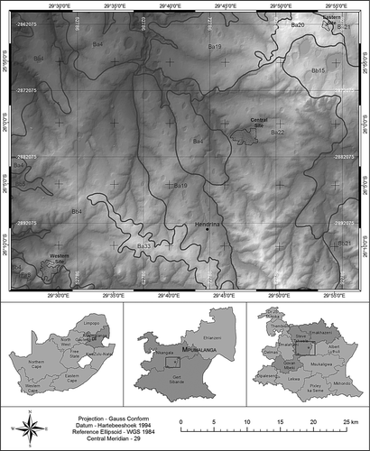
Soil survey data (422 points) were obtained from three detailed soil surveys that were conducted previously by the author on different sites on the Mpumalanga Highveld (). The field surveys were conducted on fixed grids (approximately 150–200 m). The data gathered included Munsell® (Munsell® Colour Company, Inc. Baltimore, MD, USA) soil colour (topsoil and subsoil horizons), texture (field determined), and degree of structural development, mottles, and other parameters relevant to the identification of master and diagnostic horizons. The soils were classified according to the Taxonomic System (Soil Classification Working Group Citation1991). As an orientation exercise, land type data was obtained from the Agricultural Research Council– Institute for Soil Climate and Water (Land Type Survey Staff Citation1972–2006). The land type data is presented at a scale of 1:250 000 and entails the division of land into land types, typical terrain cross-sections for the land type and the presentation of dominant soil types for each of the identified terrain units (in the cross-section).
Figure 1: Land type and orientation map of the survey area indicating the three sites
The colour descriptions were compared in terms of hue, chroma and value for all similar diagnostic horizons as well as between the topsoil and subsoil horizons. The surveys were conducted in winter months and the colours reported for A and E horizons are all in the dry state. Colours reported for the other horizons were in the moist state except for cases where these horizons were naturally dry, in which case the dry state colour was recorded. In addition to the data for topsoils overlying red apedal, yellowbrown apedal and E horizons, the data for topsoil horizons overlying hard plinthic, soft plinthic and G horizons were also included.
Results and discussion
The surveys were conducted in land types Ba20, Ba22 and Bb4 (). The colour hue, value and chroma (Munsell® notation) for each topsoil horizon and subsoil red apedal, yellow-brown apedal, and E horizon are reported in to , respectively. The hue data () reflects the defined colour criteria for the red apedal, yellow-brown apedal and E horizons as stipulated in the Taxonomic System (Soil Classification Working Group Citation1991).
Table 1: Number of survey samples for each soil colour hue and diagnostic horizon
The data for the sampled soils () indicate a distinct (but often variable) decrease in the topsoil horizon colour value with an increasing degree of wetness in the subsoils. The trend is reversed in the subsoils as an increasing degree of wetness leads to an increase in soil colour value. The comparison of the two sets of data in in terms of soil forms indicates that the difference in soil colour value between topsoil and subsoil horizons is very marked for all soils with E-horizons, where the subsoil colour value was markedly higher than the topsoil colour value. This aspect conforms to the proposed genesis and definition of an E-horizon in the Taxonomic System (Soil Classification Working Group Citation1991). Topsoil colour value therefore decreases (becomes darker) and subsoil colour value increases (becomes lighter) with increasing wetness.
Figure 2: Soil colour values (topsoil and subsoil) for the classified soils. Error bars indicate the standard deviation and bars indicate average values
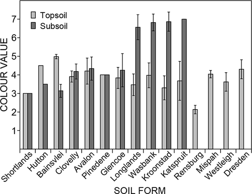
Figure 3: Soil colour chromas (topsoil and subsoil) for the classified soils. Error bars indicate the standard deviation and bars indicate average values
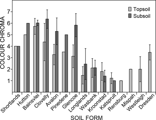
Table 2: Number of survey samples for each soil colour value for the survey samples and diagnostic horizons
The soil colour chroma of the sampled points () indicates a distinct (but often variable) decrease for the topsoil horizons as well as for the subsoil horizons with increasing subsoil wetness. The difference in chroma between topsoil and subsoil horizons in the same soil form was predominantly less than one chroma unit for soils with red apedal or E horizons. The difference in chroma between topsoil and subsoil horizons of soils with yellowbrown apedal horizons often approached two chroma units. Whereas the chroma of yellow-brown apedal B horizons was similar to that of red apedal B horizons, the chroma of A horizons overlying the yellow-brown horizons approached that of the A horizons overlying E horizons. Therefore, a clear trend in increased degree of bleaching was observed for A horizons in yellow-brown apedal soils.
Table 3: Number of survey samples for soil colour chroma and diagnostic horizons
Conclusions and recommendations
Topsoil colour chroma did not correlate well with the chroma of the subsoil throughout a soil sequence on the plinthic catena. This was especially evident in topsoil horizons overlying yellow-brown apedal B horizons. Although the phenomenon has been observed widely by the author on the plinthic catena landscapes of the Mpumalanga Highveld, it has only now been empirically confirmed in this investigation.
The distinctly lower chroma in the A horizons overlying yellow-brown apedal B horizons is attributed to a wetter soil water regime in these A horizons than those overlying red apedal B horizons. As the chroma in A horizons overlying yellow-brown apedal B horizons approached that found in many A horizons overlying E horizons, it is postulated that these have similar water regimes. The fact that the subsoil horizons exhibit a higher chroma in the form of yellowbrown colours is attributed by Fey (Citation2010) to the stabilising effect of Al on the goethite, the dominant Fe mineral in these horizons, in a wetter soil moisture regime. Fey (Citation2010) does not, however, present data on the topic and it is recommended that a dedicated investigation be conducted to elucidate the mechanism of Fe-mineral stabilisation.
The presence of bleached (or lighter coloured) A horizons on yellow-brown apedal B horizons could indicate that these topsoil horizons play an important role in the hydrology of plinthic catena landscapes. These horizons grade into wetter A horizons overlying E horizons further down the slope of the catena. Whereas the distinct lateral flow of water in E horizons has been observed numerous times during field surveys, it is postulated that the bleached A horizons overlying yellow-brown apedal subsoils could act in a similar manner albeit with more intermittent water flows during rainfall events. These intermittent flows of water, taking place within the root zone of plants, could lead to significant Fe removal through reduction as a result of prolonged wetness.
Although more accurate textural data than the in-field determinations is lacking for the samples, a distinct observation was that the bleached topsoils had a sandier texture than their associated subsoils. This is consistent with family criteria that distinguish between luvic (distinct increase in clay from the A to the B1 horizon) and non-luvic soils profiles – making most of the yellow-brown apedal profiles during the investigations ‘luvic’. The luvic nature of the profiles leads to a decrease in infiltration rate between the A and B horizons because of differential hydraulic conductivity. This implies that a degree of ponding would occur within the A horizon after rainfall events (overlying the luvic B horizon), therefore leading to a distinct possibility of increased Fe reduction in the A horizon when compared to the B horizon. This postulation warrants dedicated investigations into the hydrology of plinthic catena soils.
It is imperative that the hydrology of plinthic catena soils be elucidated in more detail as the bulk of the opencast coal mining activities on the Eastern Mpumalanga take place within such landscapes. During the operation and rehabilitation of opencast coal mining activities it is critical that the hydrology of the landscapes be understood and managed to ensure adequate water management for security of supply and quality purposes.
The author is aware of several unpublished attempts at classification of soils from colour satellite images and colour aerial photographs. In these exercises surface soil colour is often one of the main inputs in the delineation of homogenous soil areas. Based on the data presented here it is clear that the presence of bleached horizons overlying higher chroma subsoils could lead to erroneous delineation of soils if adequate field verification is not conducted.
Related Research Data
References
- Cornel , RM and Schwertmann , U. 2003 . The Iron oxides: structure, properties, reactions, occurrences and uses , 2nd edn , Weinheim : Wiley-VCH Verlag .
- Department of Water Affairs and Forestry . 2005 . A practical field procedure for identification and delineation of wetlands and riparian areas . Pretoria : Department of Water Affairs and Forestry .
- Fey , M. 2010 . Soils of South Africa: their distribution, properties, classification, genesis, use and environmental significance , Cape Town : Cambridge University Press .
- Land Type Survey Staff . 1972–2006 . Land types of South Africa: digital map (1:250 000 scale) and soil inventory databases . Pretoria : ARC–Institute for Soil, Climate and Water .
- MacVicar CN , de Villiers JM , Loxton RF , Verster E , Lambrechts JJN , Merryweather FR , Le Roux J , van Rooyen TH , Harmse HJ von M. 1977 . Soil classification: a binomial system for South Africa . Scientific Bulletin no. 390 . Pretoria : Depertment of Agriculture Technical Services .
- Milne , G. 1935 . Some suggested units of classification and mapping particularly for East African soils . Soil Research , 4 : 183 – 198 .
- National Research Council . 1995 . Wetlands: characteristics and boundaries . Washington , DC : National Academy Press .
- Richardson , JL and Vepraskas , MJ. 2000 . Wetland soils: their genesis, morphology, hydrology, landscapes and classification , Boca Raton : CRC Press .
- Soil Classification Working Group . 1991 . Soil classification: a taxonomic system for South Africa. Memoirs on the Agricultural Natural Resources of South Africa no.15 . Pretoria : Department of Agricultural Development .
- US Army Corps of Engineers, Environmental Laboratory . 1987 . Corps of Engineers wetlands delineation manual . Wetlands Research Program Technical Report Y-87-1 . Washington , DC : US Army Corps of Engineers .
- van Huyssteen , CW , Ellis , F and Lambrechts , JJN. 1997 . The relationship between subsoil colour and degree of wetness in a suite of soils in the Gabrouw district, western Cape II. Predicting duration of water saturation and evaluation of colour definitions for colourdefined horizons . South African Journal of Plant and Soil , 14 : 154 – 157 .