
Abstract
Although anthropogenic salinisation and sodification has been researched extensively, little is known about the primary salinity in South Africa. This paper therefore aimed to determine the primary salinity, sodicity and alkalinity conditions for South African soils, based on geological units and groundwater regions, and analysed soil pHwater, electrical conductivity (EC) and exchangeable sodium percentage (ESP). Soils in the Whitehill Formation (Ecca Group) geological unit were the most saline (median EC = 2720 mS m-1) and the most sodic (median ESP = 79.8). Based on the groundwater regions, soils in the Tanqua Karoo were the most saline (median EC > 400 mS m-1), whereas those in the Richtersveld were the most sodic (median ESP > 20). Soils in the Richtersveld Subprovince and in the Eendoorn granite geological units, as well as soils in the Richtersveld, Ghaap Plateau and Western Kalahari groundwater regions were the most alkaline (median pH > 8.5). The highest EC values were found in soils occurring in the geological units of the arid western part of the Northern and Western Cape. For the groundwater regions, soils in closed basins, pan environments and in intermontane areas had the highest EC values. The arid areas of the Northern Cape and Western Cape were also the most sodic. The most alkaline geological units occurred in the Namaqua Sector of the Namaqua-Natal Province, and in the Richtersveld, Ghaap Plateau and Western Kalahari groundwater regions.
Introduction
Anthropogenic salinisation and sodification has been the scourge of agriculture for millennia. However, little information is available on the primary salinity that existed before anthropogenic intervention.
Weathering, soil formation and surface processes, such as salinisation, sodification and alkalinisation, are all to some extent controlled by the parent material and therefore the underlying rock type. It is, however, difficult to make generalisations about potential salt levels in soils arising from different rock types because much of the salt may be derived from external sources (Isbell et al. Citation1983). Geological material is highly variable in its elemental composition, with some materials having or generating more salt than others. Shale, especially those of marine origin, can supply large quantities of soluble salts when water passes over or through it (Abrol et al. Citation1998). Woodford and Chevallier (Citation2002) indicate that the coastal sections of the Karoo rock in KwaZulu-Natal and the Eastern Cape show elevated sodium concentrations and may be the result of wind-borne sea salt in which sodium dominates as the main cation. However, according to Gunn and Richardson (Citation1979) not all marine sediments are high in salt, because the saline water is generally not retained during the lithification process.
Salts are generated during the weathering of minerals (Abrol et al. Citation1998). Chemical composition alone is not a sure indication of mineral weatherability, because minerals of the same composition often weather at different rates (Ollier and Clayton Citation1969). According to Ollier and Clayton (Citation1969), the rate of weathering of a mineral depends on several factors, the main of which are crystal size, shape and perfection, as well as access of agent and removal of weathered product. The main source of all salts in the soil is therefore primary minerals in the exposed layer of the Earth's crust. Klein and Hurlbut (Citation1999) extensively discuss the carbonate, halide, sulphate and borate mineral groups, responsible for salt-affected soils, and their characteristics.
The Karoo Supergroup dominates the geological map of South Africa, covering the majority of the country. The depositional environments in the Karoo Basin varied from marine for the Dwyka Group to lacustrine for the lower Ecca Group (Herbert and Compton Citation2007). The lower Ecca Group shale (Prince Albert formation) is marine basin or shelf deposited. However, in the eastern portion of the Main Karoo Basin, paleontological evidence (Anderson Citation1970; Savage Citation1970) suggests a fresh-water periglacial environment for upper Dwyka deposits, while stable isotope analyses (Faure and Cole Citation1999) from sites along the northern and southern margins of the basin indicate a brackish to fresh water depositional environment for the lower Ecca Group. The Ecca sedimentation grade upwards into the Beaufort Group, whose shale and sandstone were deposited on enormous semi-arid river plains and were subject to strong seasonal variations in sedimentation (Smith et al. Citation1993). The Karoo Supergroup sediments were capped by 1.4-kilometre-thick basaltic lava (Cole Citation1992). Rowsell and de Swardt (Citation1976) estimate that at least 3 000 m of this material was removed to reveal the present surface of the Southern Karoo. A total of 5 490 kg km-2 y-1 of cations may therefore have been released as a result of rock weathering in the area (Rowsell and de Swart Citation1976).
Schloemann (Citation1994) states that the underlying geological material mainly determines the chemical composition of salt affected soils. It is, however, difficult to find a soil profile that developed on a uniform parent material (Brewer Citation1976). According to Netterberg (Citation1969), the effect of the chemical composition of the parent material is marked in areas of essentially no calcification. Nell and Steenekamp (Citation2006), conversely, found on non-calcareous parent material, such as the Nebo-Granite, small younger intrusions of diabase sills that have had a strong influence on the development of carbonate horizons, overshadowing the dominant lithology. Therefore, soil salinity may or may not be related to geological units.
Salinisation and sodification are major factors in the deterioration of land. With increasing salt build-up, the quality and quantity of salts determine soil physical, chemical, biological and mineralogical attributes. For any long-term solution for the amelioration of salt-affected soils, it is necessary to understand and classify the origin of salt-affected soils and the likely approaches for reclamation and successful management. The purpose of the study was therefore to determine the primary salinity, sodicity and alkalinity for South African soils in relation to geological units and groundwater regions. A complementary paper (Nell and van Huyssteen Citation2014) discusses the relationship between primary soil salinity, sodicity and alkalinity and soil classification groups and rainfall classes.
Methodology
Collation of the profile data, chemical, and statistical analyses are described by Nell and van Huyssteen (Citation2014).
Geological data (with 302 units) was obtained from the Council for Geoscience on a 1:1 000 000 and/or 1: 250 000 scale. Standard international stratigraphic terminology (South African Committee for Stratigraphy Citation1996) was used when referring to specific portions of the South African geological record namely supergroup, group and formation. These terms, ranked in descending order of magnitude, reflect stacked successions of layered or stratified rocks of sedimentary and/or volcanic composition. Igneous intrusions were generally termed complexes, while assemblages of metamorphic rocks were known as suites, complexes or, if very large, provinces.
Groundwater regions (Vegter Citation2001) were used in this study as an overlay to reduce the number of polygons, while at the same time attempting to retain some uniformity with respect to lithostratigraphy, physiography and climate. Vegter (Citation1990) used lithostratigraphic unit and/or geologic structure was used as primary indicator in the delineation of the majority of groundwater regions, while physiography and a combination of physiography and geology was used in the delineation of the rest.
Soil profile points were overlaid with the geological unit and groundwater region spatial data. The geological unit and groundwater region with the highest median soil value were ranked twentieth and the lowest median value was ranked first. All relevant analytical data available for the profile was considered in the calculation.
Results and discussion
Electrical conductivity
Geological units
The soils in the nearly 300 geological units were predominantly non-saline and only 18 units had soil median electrical conductivity (EC) values higher than 100 mS m-1 (). Only the Whitehill Formation (2 730 mS m-1), Knersvlakte Subgroup (825 mS m-1) and Hoogoor Suite (410 mS m-1) were saline, when a threshold of 400 mS m-1 was applied.
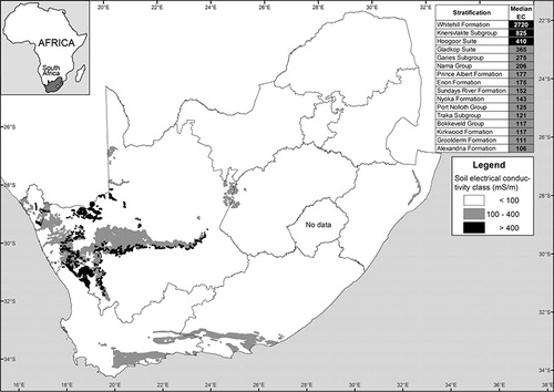
The Whitehill Formation in the Ecca Group was deposited predominantly in a marine or in a brackish non-marine environment, with a wide geographical distribution of approximately 150 000 km2 (Christie Citation1990). The formation's black laminated carbonaceous shale, with chert and graphite lenses and pyrite stringers, were deposited by suspension settling in a young underfilled foreland basin under bottom reducing conditions (Cole and McLachlan Citation1991; Visser Citation1992; Branch et al. Citation2007). The mud rocks weather white, making it a useful marker unit (Johnson et al. Citation2006). According to Branch et al. (Citation2007) the formation appears white due to the weathering of pyrite sulphide to sulphate, possibly contributing to the high salinity of the formation. The Prince Albert Formation (seventh-highest median soil EC of 177 mS m-1) also has black carbonaceous shale and pyrite-bearing shale (Woodford and Chevallier Citation2002). The black shale represents suspension settling of mud under reducing conditions, but the salinity source remains unresolved with some researchers proposing a (1) marine water body (Oelofsen and Araujo Citation1987; Visser Citation1992), (2) non-marine brackish water body with no connection to oceans (Veevers et al. Citation1994), (3) huge freshwater lake characterised by algal blooms (Faure and Cole Citation1999), and (4) sea-level high stand under restricted oceanic circulation (Visser Citation1986, Citation1992).
The majority of the 20 highest median soil EC values were located in the arid western part of South Africa (). One exception was the Nyoka Formation (tenth-highest EC of 143 mS m-1) found in the northern part of KwaZulu-Natal. The Nyoka Formation consists predominantly of red and purple mudstone with calcareous concretions, probably deposited on the floodplains of slow-flowing rivers under arid conditions (Johnson et al. Citation2006). Other exceptions were soils formed from the onshore Post-Karoo Mesozoic deposits of the Uitenhage Group in the Eastern Cape (the Enon Formation, with eighth-highest EC of 175 mS m-1, the Sundays River Formation, with ninth-highest EC of 152 mS m-1, and the Kirkwood Formation, with fourteenth-highest EC of 117 mS m-1). The high soil EC values of the Uitenhage Group were probably caused by a combination of factors, the most important of which was probably Cretaceous sea-level rises, covering the coastal plain with shallow marine deposits, resulting in the saline environments (McCarthy and Rubidge Citation2005).
Groundwater regions
Only the Tanqua Karoo groundwater region median soil EC (785 mS m-1) was saline. Seven of the 20 highest median soil EC values were from groundwater regions composed of Carbo-Triassic strata and a further nine occurred in the arid western part of the Northern and Western Cape (). The principal rock types in the Tanqua Karoo ground-water region are Dwyka Formation tillite and shale, Prince Albert Formation shale, Whitehill Formation carbonaceous shale and pyrite, Tierberg Formation shale, and Waterford Formation shale and sandstone (Vegter Citation2001). The Richtersveld groundwater region (with the second-highest EC of 355 mS m-1) and the Knersvlakte groundwater region (with the third-highest EC of 161 mS m-1) consist mostly of Namibian Gariep Supergroup quartzite, arkose, arenite, limestone, dolomite, diamictite, phyllite, schist, amphibolite and gneiss (Vegter Citation2001).
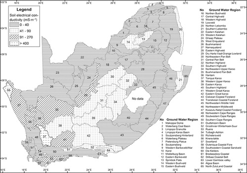
Partially closed basins, such as the Tanqua Karoo basin (with the highest EC of 785 mS m-1), the Algoa Basin (with the sixth-highest EC of 84 mS m-1), the Oudtshoorn Basin (with the fourteenth-highest EC of 76 mS m-1), and the Limpopo Karoo Basin (with the eighteenth-highest EC of 54 mS m-1) tended to have high soil EC values. Pan environments such as the Bushmanland Pan Belt (with the sixth-highest EC of 109 mS m-1), the Central Pan Belt (with the sixteenth-highest EC of 59 mS m-1) and intermontane areas (such as the Tulbagh-Ashton Valley, with the twelfth-highest EC of 84 mS m-1) also tended to have high EC values.
Exchangeable sodium percentage
Geological units
The median threshold exchangeable sodium percentage (ESP) soil values showed that the nearly 300 geological units () were predominantly non-sodic and only the Whitehill Formation (ESP = 79.8), Knersvlakte Subgroup (ESP = 29.7), Gladkop Suite (ESP = 21.6) and Malmesbury Group (ESP = 15.9) were sodic (ESP > 15; United States Salinity Laboratory Staff Citation1954). Most sodic soils occurred in the arid areas of the Northern and Western Cape. Soil with moderately high sodium content (ESP > 6) also occurred in the drier parts of the Eastern Cape, Free State, KwaZulu-Natal, Limpopo and Mpumalanga (). There was also a tendency for some of the most sodic soils to develop in geological units rich in granite and gneiss (Gladkop Suite, Spektakel Suite, Garies Subgroup and Eendoorn Granite). Some of the most sodic soils developed on geological units with a predominately marine depositional environment (Port Nolloth, Bredasdorp and Malmesbury Groups, Knersvlakte Subgroup, and Porterville, Sundays River, Kirkwood, Nanaga and Alexandria Formations). These soils additionally probably also received sodium-rich coastal rainfall or fog.
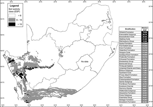
The halite crystals in the Whitehill Formation (Strydom Citation1979; van der Westhuizen et al. Citation1981; Prinsloo Citation1989) were probably a major cause of the high soil sodicity in this formation. In the Knersvlakte Subgroup, the most important cause of high soil sodicity was probably the topographic position and climatic conditions under which the salts accumulated. Gresse (Citation1992) finds the Na2O content in the Knersvlakte Subgroup is only between 0.92% and 2.45% (m/m) in the sandstone and between 1.10% and 1.64% (m/m) in the shale. According to Wedepohl (Citation1971) the Na2O content of sea clay is in the order of 5.39% (m/m). The Malmesbury Group (fourth-highest ESP of 15.9) represents a predominately marine sedimentary assemblage (Theron Citation1983). The high soil sodicity in the Malmesbury Group was probably not due to the marine shale of the Group alone, because the Na2O content is only 1.5% (m/m) for the shale (Gresse Citation1992). Dissolution of relict marine salt deposits occurs at coastal but not inland pans in the Darling area (Smith and Compton Citation2004). Smith and Compton (Citation2004) also indicated that the amount of sodium released into solution by feldspar weathering from the granite is relatively minor compared to the large contribution from coastal rainfall. Rainfall adjacent to the coast in the Western Cape has a chemical signature similar to seawater (Soderberg Citation2003). The high soil sodicity in the Gladkop Suite (third-highest ESP of 21.6) is most likely the result of the weathering of the gneiss in this suite, because Na2O range from 2.58% to 5.40% (m/m) in the gneiss (Reid and Barton Citation1983).
Groundwater regions
The median threshold ESP soil values showed that the soil in the 65 groundwater regions () were predominantly non-sodic, with only the Richtersveld (ESP = 27.6) and Tanqua Karoo (ESP = 25.4) groundwater regions being sodic. Groundwater regions with the highest soil ESP tended to occur in the arid western part of South Africa, in intermontane areas (such as the Tulbagh-Ashton valley), groundwater regions that are partially closed basins (the Tanqua Karoo, Oudtshoorn and Algoa basins), and areas where coastal rain and fog occurs (Richtersveld, Namaqualand, Bredasdorp Coastal Belt, Algoa Basin, Lower Gamtoos Valley, Outenikwa Coastal Foreland, Southwestern Coastal Sandveld and Stilbaai Coastal Belt).
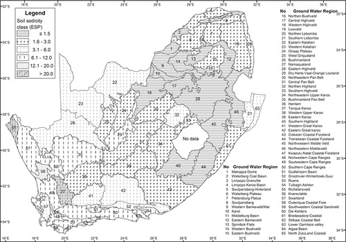
The Richtersveld groundwater region, which had the highest median soil ESP of 27.6, consists mostly of Namibian and Cambrian Period material and is represented by rocks of the Richtersveld Suite, the Gariep Supergroup and Nama Group (Vegter Citation2001, Gresse et al. Citation2006). Although the gneiss, granite and tertiary raised beach deposits and alluvium contribute to high sodicity, a large salt contribution is also expected from coastal rainfall and fog, because geological weathering and therefore salt release is expected to be very slow in this extremely arid environment. The Tanqua Karoo groundwater region had the second-highest soil ESP of 25.4. The geological material in the Tanqua Karoo groundwater region is mostly from the Whitehill, Prince Albert and Waterford Formations. These formations are some of the most sodic geological units in South Africa. The Knersvlakte groundwater region (third-highest median soil ESP of 14.5) consists mostly of sediments from the Knersvlakte Subgroup that has the second-highest median soil ESP geological unit.
Soil alkalinity
Geological units
The majority of alkaline soils () occurred in the low rainfall areas of the Northern Cape, although extensive areas were also found in the higher rainfall areas of Limpopo that are associated with granite, gneiss, anorthosite, and gabbronite geological units. In the Eastern Cape, the alkaline soils could be associated with relatively young marine sediments.
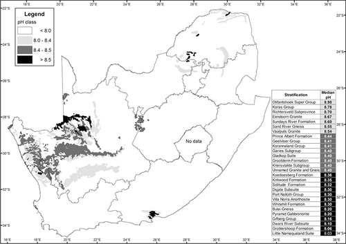
The most alkaline soil occurred in the Richtersveld Subprovince and in Eendoorn granite; both were of the Namaqua Sector in the tectono-stratigraphic Namaqua-Natal Province (Cornell et al. Citation2006). Both had a median soil pHwater of 8.7. Other geological units with high soil alkalinities in the Namaqua Sector of the Namaqua-Natal Province were the Geelvloer Group, Korannaland Group, Garies Subgroup and Gladkop Suite. These geological units are characterised by granite, syenite, granodiorite and gneiss. The Richtersveld Subprovince, with the shared-highest soil alkalinity, comprises the 2 000 Ma old calc-alkaline volcanics of the Orange River Group and the 1 900–1 730 Ma intrusive Vioolsdrift granitoid batholith (Reid et al. Citation1987, Eglington Citation2006). The Eendoorn granite is rich in microcline, biotite, quartz and plagioclase, with silmanite and cordierite as additional minerals (Visser Citation1989). The sediments in the Sundays River Formation (third-highest median soil pHwater of 8.6), KirkwoodFormation (fourteenth-highest median soil pHwater of 8.4), and Port Nolloth Group (seventeenth-highest median soil pHwater of 8.3) are all of marine origin.
The Price Albert Formation, with a median pHwater of 8.4, consisting of mudstone, chert, carbonatic, phosphatic nodules and lenses (Scheffler et al. Citation2006), was the formation in the Karoo Supergroup with the highest soil alkalinity. The Geelvloer Group, with a median soil pHwater of 8.4, consists of calc-silicate, biotite-chlorite schist, quartzite and pyrite (Visser Citation1989, Salt River Resources Citation2006).
According to Martini and Wilson (Citation1998), economically significant resources of carbonates are generally hosted within the following five sedimentary units: (1) the Malmani Subgroup, (2) the Campbell Rand Subgroup, (3) the Malmesbury Group, (4) the Nama group, and (5) Tertiary to Quaternary coastal limestone along the Cape coast. None of these sedimentary units had a median soil pHwater of more than 8.2, an indication that geological carbonates alone do not contribute to high soil alkaline conditions.
Groundwater regions
The most alkaline soils occurred in the Richtersveld, Ghaap Plateau and Western Kalahari groundwater regions with a median soil pHwater of 8.5 (). The Limpopo Karoo Basin groundwater region in the northern part of South Africa with a median soil pHwater of 8.5 was also alkaline ().
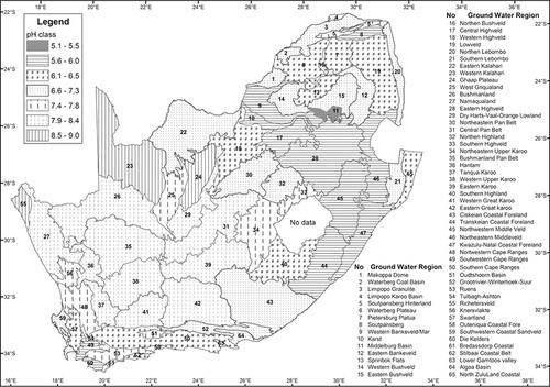
The Richtersveld groundwater region consists of Namibian strata, rich in biotite granite, gneiss, quartzite, arkose, arenite, limestone, dolomite, diamictite, phyllite and schist (Vegter Citation2001). The Ghaap Plateau groundwater region consists of Vaalian strata of the Campbell Rand and Schmidtsdrif Subgroups and Vryburg Formation, with limestone, dolomite, chert, andesite and shale dominant (Vegter Citation2001). The Western Kalahari groundwater region consists of Kalahari Group calcareous sand, sandstone, and clay; Brulpan Group muscovite, quartzite and schist; Wildenhoutsdrif Group phyllite; Koras Group sandstone and basalt; Dwyka Formation tillite; and Prince Albert Formation shale (Vegter Citation2001). The Bushmanland Pan Belt, Tanqua Karoo and Limpopo Karoo Basin groundwater regions all had a median soil pHwater of 8.4 (fourth highest) and parent material predominantly of the Carbo-Triassic strata origin (Vegter Citation2001).
Conclusion
Soil salinity, sodicity and alkalinity are most widespread in the arid and semi-arid regions of South Africa, but salt-affected soils also occur extensively in subhumid and humid climates, particularly in coastal regions where there is ingress of seawater through estuaries, rivers and ground-water. Salt-laden coastal rainfall and/or fog also contribute to salt accumulation in the soil.
The relative area affected by primary salt-affected soils in South African is much less than in countries such as Australia, Canada, Hungary, Israel, India, Pakistan and Namibia. The main reason for this is probably because South African soils are mostly derived from geological material such as shale, sandstone, dolerite, andesite, gabbro and basalt that is calcium- and not sodium-dominant. Soluble salts occur in significant proportions mostly in the more arid areas of South Africa. Therefore, transient salinity, or salinity not influenced by groundwater processes and rising water table, is the predominant salinity type in South Africa, and not dryland salinity.
The soil of the Whitehill Formation in the Ecca Group was the most saline and sodic geological unit in South Africa. The soil in the Tanqua Karoo groundwater region was the most saline and the soils in the Richtersveld ground-water region the most sodic. Soils of the Richtersveld Subprovince and the Eendoorn granite were the most alkaline geological units and the soils in the Richtersveld, Ghaap Plateau and Western Kalahari groundwater regions the most alkaline.
The highest median soil EC values according to geological units were in the arid western part of the Northern and Western Cape. The only exceptions were the Nyoka Formation that primarily occurs in the more humid part of the northern part of KwaZulu-Natal and the Uitenhage Group in the Eastern Cape. For the groundwater regions, relatively closed basins, such as the Tanqua Karoo, the Algoa Basin, the Oudtshoorn Basin and the Limpopo Karoo Basin had high EC values. Soils in pan environments, such as the Bushmanland Pan Belt and the Central Pan Belt, as well as in intermontane areas such as the Tulbagh-Ashton Valley, also had high EC values.
The most sodic soils (ESP > 15), according to geological units, were found in the arid areas of the Northern Cape and Western Cape. Relatively high sodic soils (ESP > 6) were also found in the drier parts of the Eastern Cape, Free State, KwaZulu-Natal, Limpopo and Mpumalanga. The groundwater regions with the highest ESP tended to occur in the more arid western and southern regions, between intermontane areas, in groundwater regions and in areas where coastal rainfall and fog occurred.
The most alkaline soil in geological units occurred in the Namaqua Sector of the Namaqua-Natal Province. The most alkaline soils in groundwater regions occurred in the Richtersveld, Ghaap Plateau and Western Kalahari ground-water regions. Most of the alkaline soils were in the western and north-western groundwater regions of South Africa, except the Limpopo Karoo Basin groundwater region in the most northern part of South Africa.
Some of the most sodic and alkaline soils therefore developed from geological units rich in granite, gneiss and anorthosite, while some of the most sodic and saline soils developed on geological units with marine depositional environments characterised by mudstone, siltstone and shale. Salt-laden coastal rainfall and/or fog also contributed to salt accumulation in the soil.
Information presented here serves as an indicator for the background or natural sodicity and alkalinity of South African soils, based on the dominant geology. This will aid in the identification of sodic and alkaline areas, aid in distinguishing between natural and anthropogenic sodicity and alkalinity, as well as aid in the mapping of primary sodicity and alkalinity.
Acknowledgements
The endeavours of the ARC–Institute for Soil, Climate and Water staff in collecting and analysing the data as well as the assistance of Me Liesl van der Westhuizen in the preparation of this manuscript are gratefully acknowledged.
References
- Abrol IP, Yadav JSP, Massoud FI. 1998. Salt-affected soils and their management. FAO Soils Bulletin 39. Rome: Food and Agriculture Organization of the United Nations. Available at http://www.fao.org/docrep/x5871e/x5871e00.htm [accessed 24 November 2012].
- Anderson A. 1970. An analysis of supposed fish trails from interglacial sediments in the Dwyka Series, near Vryheid, Natal. In: Second Gondwana Symposium, South Africa, July to August 1970: proceedings and papers. Pretoria: Council for Scientific and Industrial Research. pp 637–647.
- Branch T, Ritter O, Weckmann U, Sachsenhofer RF, Schilling F. 2007. The Whitehill Formation – a high conductivity marker horizon in the Karoo Basin. South African Journal of Geology 110: 465–476.
- Brewer R. 1976. Fabric and mineral analysis of soils. Huntington: Robert E Krieger Publishing Company.
- Christie ADM. 1990. Origin, classification and utilization of oil shales in South Africa. South African Journal of Science 86: 9–15.
- Cole DI. 1992. Evolution and development of the Karoo Basin. In: de Wit MJ, Ransome IGD (eds), Inversion tectonics of the Cape Fold Belt, Karoo and Cretaceous basins of southern Africa. Rotterdam: Balkema. pp 87–99.
- Cole DI, McLachlan IR. 1991. Oil potential of the Permian Whitehill Shale Formation in the main Karoo basin, South Africa. In: Ulbrich H, Rocha Campos AC (eds), Gondwana Seven proceedings: papers presented at the Seventh International Gondwana Symposium. Brazil: Instituto de Geociências, Universidade de Sâo Paulo. pp 379–390.
- Cornell DH, Thomas RJ, Moen HFG, Reid DL, Moore JM, Gibson RL. 2006. The Namaqua-Natal Province. In: Johnson MR, Anhaeuser CR, Thomas RJ (eds), The geology of South Africa. Pretoria: Council for Geoscience. pp 325–379.
- Eglington BM. 2006. Evolution of the Namaqua-Natal Belt, southern Africa – a geochrononological and isotope geochemical review. Journal of African Earth Sciences 46: 93–111.
- Faure K, Cole D. 1999. Geochemical evidence for lacustrine microbial blooms in the vast Permian Main Karoo, Paraná, Falkland Islands and Huab basins of southwestern Gondwana. Paleogeography, Paleoclimatology, Palaeoecology 152: 189–213.
- Gresse PG. 1992. The tectono-sedimentary history of the Vanrhynsdorp Group. Memoir of the Geological Survey of South Africa vol. 79. Pretoria: Department of Mineral and Energy Affairs.
- Gresse PG, von Veh MW, Frimmel HE. 2006. Namibian (Neoproterozoic) to early Cambrian successions. In: Johnson MR, Anhaeuser CR, Thomas RJ (eds), The geology of South Africa. Pretoria: Council for Geoscience. pp 395–420.
- Gunn RH, Richardson DP. 1979. The nature and possible origins of soluble salts in deeply weathered landscapes of eastern Australia. Australian Journal of Soil Research 17: 197–215.
- Herbert CT, Compton JS. 2007. Depositional environments of the lower Permian Dwyka diamictite and Prince Albert shale inferred from the geochemistry of early diagenetic concretions, southwest Karoo Basin, South Africa. Sedimentary Geology 194: 263–277.
- Isbell RF, Reeve R, Hutton JT. 1983. Salt and sodicity. In: Soils: an Australian viewpoint. Melbourne: CSIRO Publishing. pp 107–117.
- Johnson MR, van Vuuren CJ, Visser JNJ, Cole DI, Wickens H de V, Christie ADM, Roberts DL, Brandl G. 2006. Sedimentary rocks of the Karoo Supergroup. In: Johnson MR, Anhaeuser CR, Thomas RJ (eds), The geology of South Africa. Pretoria: Council for Geoscience. pp 461–499.
- Klein C, Hurlbut CS Jr. 1999. Manual of mineralogy (after James D Dana) (21st edn). New York: John Wiley and Sons.
- Martini JEJ, Wilson MGC. 1998. Limestone and dolomite. In: Wilson MGC, Anhaeusser CR (eds), The mineral resources of South Africa. Handbook 16. Pretoria: Council for Geoscience. pp 433–440.
- McCarthy T, Rubidge B. 2005. The story of Earth and life: a southern African perspective on a 4.6-billion-year journey. Cape Town: Struik Publishers.
- Nell JP, Steenekamp PI. 2006. RESIS Project: soil survey for Van der Merweskraal-Doornpoort irrigation scheme. Report no. GW/A/2006/184. Pretoria: ARC–Institute for Soil, Climate and Water.
- Nell JP, van Huyssteen CW. 2014. Soil classification groups to quantify primary salinity, sodicity and alkalinity in South African soils, South African Journal of Plant and Soil. DOI: 10.1080/02571862.2014.921941.
- Netterberg F. 1969. The geology and engineering properties of South African calcretes. PhD thesis, University of the Witwaters-rand, South Africa.
- Oelofsen BW, Araujo DC. 1987. Mesosaurus tenuidens and Stereosternum tumidum from the Permian Gondwana of both southern Africa and South America. South African Journal of Science 83: 370–372.
- Ollier C, Clayton KM. 1969. Weathering. Edinburgh: Oliver and Boyd.
- Prinsloo MC. 1989. Britstown, explanation sheet 3022. Pretoria: Government Printer.
- Reid DL, Barton ES. 1983. Geochemical characterization of granitoids in the Namaqualand geotraverse. In: Botha BJV (ed.), Namaqualand metamorphic complex: a contribution to the National Geodynamics Programme. Special Publication 10. Johannesburg: Geological Society of South Africa. pp 67–82.
- Reid DL, Welke HJ, Erlank AJ, Betton PJ. 1987. Composition, age and tectonic setting of amphibolites in the central Bushmanland Group, Western Namaqua Province, southern Africa. Precambrian Research 36: 99–126.
- Rowsell DM, de Swardt AMJ. 1976. Diagenesis in Cape and Karoo sediments, South Africa and its bearing on their hydrocarbon potential. Transactions of the Geological Society of South Africa 79: 81–145.
- Salt River Resources. 2006. Salt River Project - Overview. Available at http://www.srr.co.za/Salt_River_Project.html [accessed 23 November 2012].
- Savage NM. 1970. A preliminary note on arthropod trace fossils from the Dwyka Series in Natal. In: Second Gondwana Symposium, South Africa, July to August 1970: proceedings and papers. Pretoria: Council for Scientific and Industrial Research. pp. 627–635.
- Scheffler K, Buehmann D, Schwark L. 2006. Analysis of the late Palaeozoic glacial to postglacial sedimentary successions in South Africa by geochemical proxies – response to climate evolution and sedimentary environment. Palaeogeography, Palaeoclimatogy, Palaeocology 240: 184–203.
- Schloemann H. 1994. The geochemistry of some common Western Cape soils (South Africa) with emphasis on toxic and essential elements. PhD thesis, University of Cape Town, South Africa.
- Smith M, Compton JS. 2004. Origin and evolution of major salts in the Darling pans, Western Cape, South Africa. Applied Geochemistry 19: 645–664.
- Smith RMH, Eriksson PG, Botha WJ. 1993. A review of the stratigraphy and sedimentary environments of the Karoo-aged basins of Southern Africa. Journal of African Earth Science 16: 143–169.
- Soderberg K. 2003. Geochemistry of the fynbos ecosystem in a Table Mountain Group sub-catchment of the Olifants River, Western Cape, south Africa. MSc dissertation, University of Cape Town, South Africa.
- South African Committee for Stratigraphy. 1996. Code of stratigraphic terminology and nomenclature (4th edn). Pretoria: South African Committee for Stratigraphy.
- Strydom D. 1979. The geology of an area north of Carnarvon. MSc dissertation, University of the Free State, South Africa.
- Theron JN. 1983. Geological setting of the Fynbos. In: Deacon HJ, Hendey QB, Lambrechts JJN (eds), Fynbos palaeoecology: a preliminary synthesis. South African National Scientific Programmes Report no. 75. Pretoria: CSIR.
- United States Salinity Laboratory Staff. 1954. Diagnosis and improvement of saline and alkali soils. Agriculture Handbook no. 60. Washington, DC: US Government Printing Office
- van der Westhuizen WA, Loock JC, Strydom D. 1981. Halite imprints in the Whitehill Formation, Ecca Group, Carnarvon District. Annals of the Geological Survey of South Africa 15: 43–46.
- Veevers JJ, Cole DI, Cowan EJ. 1994. Southern Africa: Karoo Basin and Cape Fold Belt. In: Veevers JJ, Powel C McA (eds), Permian-Triassic Pangean Basins and Foldbelts along the Panthalassan Margin of Gondwanaland. Boulder: Geological Society of America. pp 223–279.
- Vegter JR. 1990. Ground-water regions and subregions of South Africa. Directorate of Geohydrology Technical Report no. GH 3697. Pretoria: Department of Water Affairs and Forestry.
- Vegter JR. 2001. Groundwater development in South Africa and an introduction to the hydrogeology of groundwater regions. Report no. TT 134/00. Pretoria: Water Research Commission.
- Visser DJL. 1989. Die geologie van die Republieke van Suid Afrika, Transkei, Bophuthatswana, Venda en Ciskei en die Koninkryke van Lesotho en Swaziland. Pretoria: Government Printer.
- Visser JNJ. 1986. Geology. In: Cowling RM, Roux PW, Pieterse AJH (eds), The Karoo biome: a preliminary synthesis. Part 1: Physical environment. Report no. 124. Pretoria: CSIR. pp 1–17.
- Visser JNJ. 1992. Deposition of the early to late Permian Whitehill Formation during a sea-level highstand in a juvenile foreland basin. South African Journal of Geology 95: 181–193.
- Wedepohl KH. 1971. Geochemistry. New York: Holt, Rinehart and Winston.
- Woodford AC, Chevallier L. 2002. Hydrogeology of the Main Karoo Basin: current knowledge and future research needs. Report no. TT 179/02. Pretoria: Water Research Commission.