Abstract
The flooding and drying mechanisms of the seasonal flood plains of the Sudd swamps in southern Sudan are, while dependent on the river levels, influenced by a complex interaction between soil, vegetation, topography and seasonal trends in rainfall and evapotranspiration. Based on field measurements, these components have been assessed in detail and evaluated regarding their function in the seasonal cycle of flooding and drying. A detailed analysis of soil and evapotranspiration conditions, as well as the interaction with vegetation and meteorological conditions, has been conducted using field and laboratory experiments. Sources, processes, flow directions and the fate of the floodwaters on both the river-fed seasonal flood plains and the rain-fed grasslands have been established. The results show that river spill is responsible for flooding these areas while no return flow occurs, and drying is caused by evapotranspiration. Rainfall can only cause temporary flooding in extreme events.
Citation Petersen, G. & Fohrer, N. (2010) Flooding and drying mechanisms of the seasonal Sudd flood plains along the Bahr el Jebel in southern Sudan. Hydrol. Sci. J. 55(1), 4–16.
Mécanismes d'inondation et d'assèchement des plaines d'inondation saisonnière de Sudd le long de Bahr el Jebel au sud du Soudan
Résumé Les mécanismes d'inondation et d'assèchement des plaines d'inondation saisonnière des marais de Sudd au sud du Soudan sont, bien que dépendant des niveaux des rivières, influencés par des interactions complexes entre le sol, la végétation, la topographie et les tendances saisonnières de pluie et d'évapotranspiration. A partir de mesures in situ, ces composantes ont été étudiées en détail et évaluées en tenant compte de leur rôle dans le cycle saisonnier d'inondation et d'assèchement. Une analyse détaillée des conditions édaphiques et d'évapo-transpiration, ainsi que des interactions avec la végétation et les conditions météorologiques, a été menée in situ et en laboratoire. Les sources, les processus, les directions d'écoulement et le devenir des eaux de crue ont été déterminés pour la plaine d'inondation saisonnière de la rivière et pour les prairies pluviales. Il a ainsi été démontré que les crues de la rivière sont responsables des inondations dans la zone concernée, alors qu'il n'y a aucun écoulement de drainage et que l'assèchement est dû à l'évapotranspiration. Les pluies occasionnent seulement des inondations temporaires lors d'événements extrêmes.
INTRODUCTION
The Sudd swamps of southern Sudan, one of the largest wetland areas in Africa, are defined by seasonal flooding and are responsible for the loss of large quantities of the inflowing waters of the White Nile, here called the Bahr el Jebel. Evaluating flow data from Hurst (Citation1933 and supplements), approximately half of the inflowing waters are lost between Mongalla and Malakal, the respective entrance and exit of the swamp system.
Historical information about the region is mainly available from studies carried out during the last century. Hurst & Phillips (Citation1931, Citation1938) and Butcher (Citation1938) were the first to carry out intensive research in the Sudd swamps, describing hydrometeorological conditions. Shrinking and swelling of the Sudd soils was investigated by Migahid (Citation1948). The Jonglei Investigation Team (JIT) Citation(1954) mapped the soil types of the Sudd and defined the area in the immediate vicinity of the swamps as sudd or toic soils. Mefit-Babtie Citation(1983) collected humidity, sunshine and temperature data during the Jonglei Canal studies at Bor and Malakal, and described the seasonal cycle of water logging and desiccation leading to deep cracking of the soil. Wright, in JIT Citation(1954) gave initial hints on soil water recharge values of between 300 and 800 mm, assuming that the latter was overestimated. Sutcliffe (Citation1974) described the vegetation distribution of different species in the swamps and Petersen et al. Citation(2007) described the vegetation dynamics with regard to changes in the permanent swamps. Hurst & Phillips (Citation1938) and Migahid (Citation1948, Citation1952) reported outcomes of different evapotranspiration experiments. Penman (Citation1963) computed evapotranspiration in the Sudd, Mohamed et al. ( Citation2004) investigated Sudd actual evapotranspiration from remote sensing data, and Mohamed et al. ( Citation2005) investigated the impact of the Sudd on the Nile hydroclimatology. Sutcliffe & Parks (Citation1999) considered evapotranspiration with a value of 2150 mm/year. The influence of the area morphology on flooding was described by Petersen et al. Citation(2008) evaluating flooding conditions in local depressions.
While, historically, a great amount of information was collected, a comprehensive analysis of the mechanisms leading to flooding and drying of the flood plains is not available. The different recent and historical studies focused on their different specific fields of investigation. While these studies give a good overview of the system, the flooding and drying mechanisms of the seasonal flooded grasslands, the toic, have so far not been described under consideration of all involved factors.
The flood plains are an important feature of the area in terms of their ecological and economic value. Detailed knowledge of their function, especially their flooding and drying mechanisms, which are the driving factors for vegetation growth, is important for a full understanding of the system and future planning tasks. The objective of this paper is integrative investigation of the processes and mechanisms of the flooding and drying cycle of the toic, describing the influence of these mechanisms on the water budget over the year. Specific objectives comprise the assessment of individual parameters of soil and vegetation in combination with precipitation and evapotranspiration, as well as an evaluation of interdependencies.
MATERIALS AND METHODS
Data used in the described assessments were derived from historical studies, as well as from measurements based on works carried out for a hydrological study as part of an environmental impact assessment, conducted between 2004 and 2006 for the South Sudan Road and Dike Rehabilitation Project (Hassan et al., Citation2006).
The study site
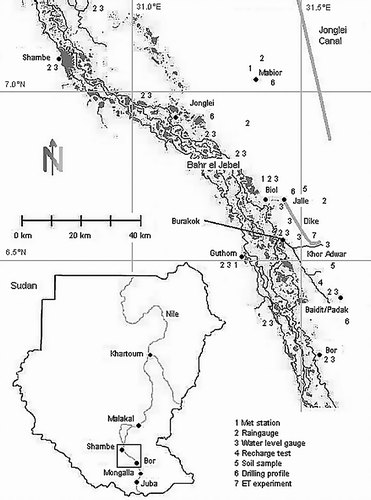
The study of the flooding and drying mechanisms of the vertisol flood plains of southern Sudan was carried out in the Bor-Jonglei area, a 100-km stretch of land in the southern part of the Sudd swamps along the right bank of the Bahr el Jebel, as shown in .
Fig. 1 Overview of the Sudd swamps between Bor and Shambe. The image shows main channels and lagoon areas.
The area has a flat topography, as described by Petersen et al. Citation(2008), and, in its hydrological regime, is dominated by the annual cycle of flooding and drying caused by river flooding and heavy rainfall. The soils of the Sudd region are typical African flood-plain black cotton soils with high clay content, classified as vertisols (IUSS Working Group WRB, Citation2006).
The plains flood in an annual cycle related to the rainy season, with the associated local rainfall and increased river discharges leading to overbank spill (Sutcliffe & Parks, Citation1999). In the dry season, the soils dry out, which leads to heavy cracking. During this period, the grassy vegetation dies and the residues are typically removed by bushfires. With the onset of the rains, vegetation growth starts again.
Geology
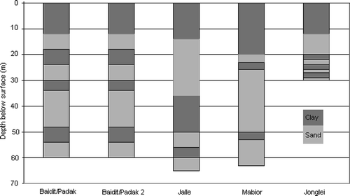
Five drilling profiles, available through borehole drilling records from OLS Water, Kenya, were used to investigate the geological situation of the area between Bor and Shambe; the locations are shown in . In addition to the evaluation of the drilling profiles, the soil profile was assessed in nine borrow pits, up to 8 m deep, between Baidit/Padak and Jalle.
Soil analysis
Soil samples were taken in 2005 at distances of 25 and 50 km north of Bor, on the eastern bank of the Bahr el Jebel, from within the seasonally flooded grassland area near to the villages of Baidit/Padak and Jalle, respectively (). Six samples in total were taken from different depths between 1 and 4 m within excavation pits. As previous tests in eight borrow pits (Hassan et al., Citation2006) had shown the soil profile to be very comparable and homogenous, the results have been averaged for the surface (< 1 m) as well as for the deeper subsurface (> 1 m) layers. The hydraulic conductivity was assessed using k f-cells in accordance with the German standard, DIN 18130 (Citation1998). The resulting k f values were reported in m/s.
Classification of the soil type was conducted using the US Department of Agriculture (USDA) Field Book for Describing and Sampling Soils (Schoeneberger, Citation2002) using the combined texture triangles based on grain-size distribution analysis, and the IUSS Working Group WRB (Citation2006). The grain-size distribution was analysed based on DIN 11277 (Citation1994) using a combination method of sieving and sedimentation after extraction of soluble salts, carbonates and organic matter. As part of the preparation of the soil samples for the grain-size analysis, the organic content and carbonate content were extracted using H2O2 and HCl, respectively.
Soil water recharge
Soil water recharge was assessed through field experiments conducted at different locations on the seasonally flooded grasslands in the Baidit/Padak area, approximately 25 km north of Bor between May 2005 and August 2006. A simple field infiltrometer was used for this task. The locations for the experiments had to be carefully selected to avoid the several-metre-long cracks which would have drained away the water quickly. The frame was then filled with water and the decrease in water level recorded at 10-min intervals until stagnant conditions were observed. In addition to the above in situ experiments, laboratory tests were conducted where the difference in soil water content between saturated and dried (and cracked) core samples was determined. The sample cores were saturated, weighed, then dried, weighed again and the difference calculated.
Soil evaporation
Soil evaporation, as present under conditions when no or only dead vegetation is available, was assessed using undisturbed surface soil samples, partly with limited dead vegetation to resemble natural conditions. The tests were conducted in Baidit/Padak, where the moisture losses of the samples were recorded at hourly time steps and the soil evapotranspiration rate deduced according to:
where EV is evaporation (mm); mx is weight at time step x (g); (g) and a surface is surface area (mm2). Experiments were carried out day and night between January and May 2006, with different cloud conditions to achieve average results.
Rainfall measurements
Rainfall data were collected beginning in April 2004 at one location in Baidit/Padak using a standard raingauge. The station network was expanded in 2005 and, from March 2005 to August 2006, field data were recorded at 15 automatic stations in the swamps and on the seasonally flooded grasslands between Bor and Shambe at daily and hourly intervals. The locations are shown in .
Recording of meteorological data
Additional meteorological data were recorded using automatic monitoring stations during the period between April 2005 and August 2006 at daily intervals. Recorded parameters comprised: wind speed at Guthom and Mabior at a height of 2.0 m above ground, solar radiation, as well as humidity and temperature at Biol and Guthom.
Actual evapotranspiration
An evapotranspiration experiment was conducted in October and November 2005, as well as in January 2006, using a naturally vegetated depression which was flooded in the rainy season and drying out slowly after the end of the rains. The 900-m2 depression received its input through precipitation within its perimeter and, after the peak of the floods had passed, was isolated from other sources of flooding. The natural vegetation of the depression was representative of the surrounding grassland area. The influence of below-surface water could be neglected due to the impermeable soil conditions; the depression was protected from animal access. The static inundation conditions provided a good representation of the surrounding flood-plain situation so that realistic actual evapotranspiration results could be expected.
Precipitation within the depression was recorded using a standard raingauge situated within the perimeter. Water-level changes, from which evapotranspiration was deduced, were recorded by a measuring rod. Daily actual evapotranspiration values for the flooded depression were calculated from:
where ET a is actual evapotranspiration (mm); wl x is the water level on day x (mm); and p is precipitation (mm). Percolation was neglected due to the prevalent soil conditions. Cloud conditions were recorded together with the data. Problems arose in accessing the site after heavy rain events so that measuring intervals varied slightly.
Evapotranspiration calculations
Local evapotranspiration for the Sudd was calculated based on meteorological records of monitoring stations located within the swamp and the seasonally flooded grassland area as shown in . The FAO Penman-Monteith method (Allen et al., Citation1998) was used in a spreadsheet calculation to determine ETC, the evapotranspiration under given conditions.
Values used in the calculation were selected from the October/November 2005 measuring period, which was also the period in which the evapotranspiration experiment had been carried out. The values used for an average calculation for this period are shown in . In addition, a daily time series was calculated using the respective daily input values measured in the same period. Based on the validated results, values given by Hurst & Phillips (Citation1931) and values recorded between April 2005 and August 2006, monthly average evapotranspiration was calculated for a whole year. Vegetation observations were used to deduce the adjusting coefficients for the given conditions.
Table 1 Parameters and values used for average evapotranspiration calculations using the FAO Penman-Monteith method for the October/November 2005 period
Vegetation observations
Vegetation and environment within the seasonally flooded grasslands between Baidit/Padak and Jalle were monitored on a monthly basis between April 2004 and August 2006. Based on detailed photographs, the state and changes of vegetation, soil condition and flooding were assessed to be compared with the meteorological measurements.
Water-level records
Recording of water levels commenced in January 2005 with basic staff gauges in the seasonally flooded grassland area. The system was improved in April 2005 through the set-up of automatic gauges, equipped with pressure transducers and data loggers, at different locations in the swamp area between Bor and Shambe. The gauges were positioned at locations along the main channels, as well as in the lagoons. The records were recalculated to a local survey datum yielding comparable data series. In addition to the automatic records, measurements were taken at Khor Adwar and along a newly constructed dike line on the seasonal flooded grasslands between Khor Adwar and Jalle at 4-km intervals. All data were logged at daily intervals; gauge locations are shown in .
RESULTS
Next to the area morphology with its very gentle gradients (Petersen et al., Citation2008) and so limited overland flows, soil characteristics and vegetation are, in combination with rainfall and evapotranspiration, the most important factors controlling the flooding and drying processes of the seasonal flooded grasslands of the Sudd area. For a better understanding of the progress and retreat of the flood waters, the individual factors of influence are described in detail followed by a detailed assessment of their interrelations and effects on the water budget of the flood plains.
Surface geology
Drilling records for the Bor-Shambe area show a situation where sandy sub-layers are overlaid by a 12–20-m-thick highly impervious clay surface layer. Soil samples taken from borrow pits confirm the presence of the upper clay layer. The drilling locations are shown in , the profiles obtained are shown in .
Fig. 2 Geological cross-section generated from drilling profiles of the Bor-Shambe area from OLS Water, Kenya.
Soil analysis
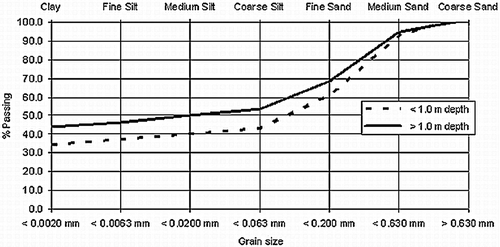
The surface layer soils of the project area are typical vertisols as described by the IUSS Working Group WRB (Citation2006). Grain size analysis shows clay contents between 25 and 49%. The results for the averaged surface and subsurface layer samples are shown in . According to the USDA Field Book for Describing and Sampling Soils (Schoeneberger, Citation2002), the soil samples consist of “sandy clay loam” at the surface and “sandy clay” for depths > 1 m. The relatively lower clay content is found at the surface.
Fig. 3 Grain size distribution of averaged surface (< 1 m depth) and subsurface (> 1 m depth) soil layers.
The hydraulic conductivity of the soil samples indicates highly impermeable conditions with k f values of 1.1 × 10⁻¹¹ and 2.1 × 10⁻¹⁰ m/s for the surface and subsurface layers, respectively. The higher impermeability is found in the surface layer.
Soil water recharge
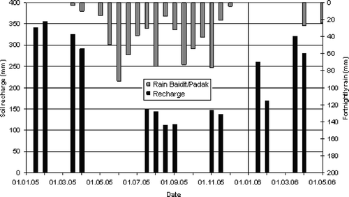
The results of the soil water recharge experiments show that values vary with rainfall over the season, and exceed 350 mm when the soil is dry. The time for infiltration of this amount was measured as typically 20–70 min, depending on soil conditions. After the soil has recharged to this amount, no further water infiltrates and conditions remain static. shows the influence of precipitation on the recharge in the rainy season. The fact that a certain amount of recharge occurs, even within the rainy season, can be explained by the magnitude of evapotranspiration. This exceeds precipitation, leading to unsaturated conditions in non-flooded areas, which affects soil water recharge rates. It needs to be noted that the experiments were conducted at locations where water was not ponding.
Fig. 4 Soil water recharge and rainfall between January 2005 and April 2006.
Initial infiltration rates for the vertisols were recorded in order to quantify the amount of water that can be taken up by the soil during heavy rainfall events. For soils of different state of pre-saturation, that consequently were not yet impervious, values of between 22 and 128 mm/(10 min) for the initial 10 min of the experiment were recorded, the average value being 77 mm/(10 min). Laboratory tests show a high soil water recharge capacity with moisture contents ranging between 30 and 51%. For the surface and deeper layers the respective average values are 35 and 45%. These values can not be directly related to recharge values in mm but confirm the high recharge capacity of the soils.
Soil cracks which provide access for water to reach deeper layers before these cracks close are a factor to be taken into account. The influence of the cracks could not be assessed with the methods used; therefore, the recharge values can be assumed to be underestimated.
Soil evaporation
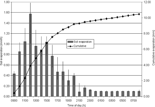
Evaporation from moist soil with no or only dried vegetation, as in the dry season, was measured to assess the amount of water evaporated by bare soil at the start of the rainy season before flooding and vegetation growth occur, along with transpiration. The results show soil evaporation values which vary depending on the time of the day, reaching up to 1.5 mm/h at noon. Daily evaporation averaged 10.5 mm. The average hourly results are shown in .
Fig. 5 Soil evaporation values during an average daily cycle.
Rainfall data
During the period April 2004–August 2006, 757 mm of rainfall were recorded for the different stations in the Bor-Shambe area, which suggests drier conditions in comparison to the average rainfall of 847 mm/year based on measurements between 1905 and 1981 (Hurst & Black, Citation1943 and supplements). The results show a rainy season lasting from late March to early November. Rain events are mostly of short duration of maximum one hour. During this time, up to 73 mm/h was recorded while an average rain event provided 14 mm/h. The spatial distribution of rain events is very localized. While the general trend and cumulative amount of rainfall at all monitoring locations was comparable, the daily intensity varied widely between no rain and considerable downpours for different locations.
Meteorological data
Wind-speed measurements range between 0.9 and 5.9 m/s daily average wind speed, showing an annual average value of 2.1 m/s. The highest values occur in April before the start of the rains. For the October/November period, in which the depression experiment was conducted, the wind speed averages 2.0 m/s. Over the year, temperatures range between 18 and 39°C, humidity ranges between 46 and 89%, and daily global solar radiation averages 24 mJ/m2. The results are shown in . Daily sunshine and daylight duration have been measured, having an average of 9 and 12 h, respectively.
Table 2 Meteorological data for the Bor-Shambe area. Monthly averages for April 2005 to August 2006
Actual evapotranspiration
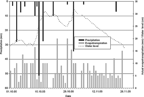
Evapotranspiration values deduced from the depression experiment have been established, with an average of 7.3 mm/d for both the October/November 2005 and January 2006 periods; the daily values are shown in . Fluctuations in the daily evapotranspiration rates correlate with weather observations showing reduced evapotranspiration on cloudy days and higher values on sunny and windy days, with maxima reaching up to 20 mm/d. Percolation has been neglected considering the impermeable soil conditions.
Fig. 6 Evapotranspiration from the October/November 2005 depression experiment showing daily evaporation rates as well as correlation between rainfall events and water-level fluctuations.
Evapotranspiration calculations
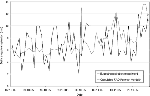
Average evapotranspiration for the October/November 2005 period was calculated at 7.3 mm/d based on daily temporal resolution using the FAO Penman-Monteith equation, an approach successfully used by Jacobs et al. Citation(2002) and Portoghese et al. Citation(2008) to assess evapotranspiration of natural vegetation. This value was calculated using the standard settings together with a condition coefficient of 0.8, based on the vegetation conditions in the depression. The selected KC value was judged to provide the best match for the vegetation conditions on the flood plains based on Allen et al. Citation(1998). The result provides a good match to the measured 7.3 mm/d obtained in the depression experiment. The comparison is shown in . Fluctuations of the measured values are obvious while the general trend correlates. The fluctuations can be explained by the daily measuring time step, which is coarser than typical rainfall events of one hour. The readings therefore strongly depend on the time lag between rain event and measurement, as well as the slightly varying measuring intervals due to accessibility problems after rain events.
Fig. 7 Comparison of calculated and measured daily evapotranspiration values.
Year-round evapotranspiration values calculated with the FAO Penman-Monteith equation at monthly resolution are given in . The total evapotranspiration per year is calculated as 2075 mm. The value of 1.9 mm/d for January differs from the depression experiment, due to different water availabilities between the depression and the surroundings, at this time drier, area.
Table 3 Evapotranspiration (ET) values calculated after FAO Penman-Monteith for the Bor-Shambe region
Vegetation conditions
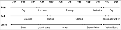
Vegetation conditions were established from observations in the seasonally flooded areas. The pattern follows the hydrological cycle and the vegetation reacts to the availability of water. The grasslands are mainly inhabited by grassy species of which Echinochloa pyramidalis (Antelope Grass), Echinochloa stagnina (Hippo Grass), Vossia cuspidata (Hippo Grass), Oryza barthii (Wild Rice) and Oryza longistaminata (Wild Rice) are the most common ones that have been observed. During the annual cycle of flooding and drying the vegetation follows the pattern of water availability. Growth starts after the first rains in April and reaches its peak in July at the peak of the floods where large areas are inundated and the grass grows over the whole water body. With decreasing flood levels, the vegetation deteriorates and dries quickly after the end of the rainfall period. In November the grass starts to burn in patches and by January all the grass is burnt and bare soil is exposed until the next growing cycle starts. The pattern is shown in .
Fig. 8 Observed conditions in the seasonal flooded grassland areas.
Observation of short distance water-level fluctuations
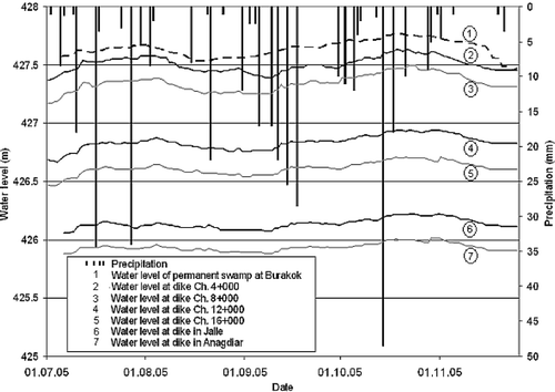
Observations of water-level fluctuations in the seasonal flooded grasslands were compared with water-level changes in the permanent swamp and with rain events. Results as displayed in show that water levels on the flood plains precisely correlate with the water levels in the permanent swamp area. No direct correlation could be established between rainfall events and water-level fluctuations on the flood plains, which indicates the small influence of rainfall on the water levels. During the receding of the floods in November 2005, flood water levels on the flood plains have been observed to decrease by on average, 5 mm/d simultaneously at all stations. Compared to this, the nearby Burakok level within the permanent swamps still showed higher water levels.
Fig. 9 Water-level fluctuations at different locations in the seasonal flooded grassland area compared to levels at Burakok station within the permanent swamps.
DISCUSSION OF FLOODING AND DRYING MECHANISMS
Components of flooding mechanism
While the influence of the region's morphology on large-scale flooding was discussed by Petersen et al. Citation(2008), local flooding mechanisms of the flood plains are, next to the water levels in the permanent swamp, influenced by different parameters. These include the soil, the vegetation and the meteorological conditions influencing evapotranspiration. Sources of flooding can generally be divided into waters spilled from the swamps and rainfall. The former cause widespread and long-term flooding of the seasonally flooded grasslands, and the latter may cause short-term shallow flooding in the rain-fed grasslands if soil water recharge capabilities are exceeded due to any of the above two sources of flooding. The difference between the measured 757 mm of annual rainfall and 2075 mm of annual evapotranspiration highlights the water deficit in the area.
The results show that the soil recharges up to 350 mm of water when dry, which can be assumed to be underestimated as the influence of soil cracks has not been taken into account during the recharge experiments. Only after this amount of water has been recharged, will flooding start. The result is higher than the value of 200 mm proposed by Sutcliffe & Parks (Citation1999), while in the lower range of the 300–800 mm suggested by Wright in JIT Citation(1954). Later in the rainy season, the partially saturated soil will recharge until, depending on the conditions, full saturation is reached. Depending on the state of the vegetation, which may vary between burnt soils and fully developed grass cover, soil evaporation can reach an average of 10.5 mm/d in the dry season. Evapotranspiration can reach 10.0 mm/d as a monthly mean during the rainy season and maxima of 20.0 mm/d during the peak of the dry season. The average annual evapotranspiration rate of 5.7 mm/d (2075 mm/year) is similar to the value stated by Sutcliffe & Parks (Citation1999), who estimated a value of 2150 mm, but higher than that of Mohamed et al. ( Citation2004), who calculated 1660 mm/year, and lower than that of Migahid (1954), whose results showed 2400 mm/year. The discrepancies may be explained by the fact that Migahid (1954) worked with papyrus, while in the current study representative grassy toic vegetation was assessed. However, Mohamed et al. ( Citation2004) obtained their data from remote sensing assessments over the whole Sudd area, including land with water deficit and, therefore, lower actual evapotranspiration. Deep percolation can be neglected considering the impermeable clay top layer in the soil profile ().
Time frames play an important role in combination with these mechanisms. Single rain events typically provide 14 mm precipitation, on average, and 73 mm, as a maximum, measured within a short time frame of less than one hour and in locally restricted areas. Soil water recharges with an average initial recharge capacity of 77 mm/(10 min) depending on initial soil saturation conditions. Depending on the season, the measured initial value varied between 22 and 128 mm/(10 min), with the higher values occurring in the dry season. Evapotranspiration as well as soil evaporation are slow mechanisms with values of around 10 mm/d. Based on these results, flooding caused by rainfall can only occur during heavy events which exceed the soil recharge capacity. The necessary amount of rainfall changes with the season and related soil pre-saturation. Assuming previous events have not saturated the soil, the water will infiltrate within a short time if not supported by additional rainfall or meteorological conditions which minimize evapotranspiration. Evaporation and evapotranspiration, while important in the long term, play a negligible role in the short-term processes described.
Indicative water budget of the flood plains
While in the Sudd swamps sources of floodwaters may originate from the upper reaches of the Nile, or from local precipitation, results show that water levels on the flood plains fluctuate with the water levels in the swamps. In addition, as shown by the measurements, soil water recharge and evapotranspiration outweigh rainfall quantities so that the source of larger-scale area flooding can be established as river floods, while rainfall has a negligible effect. When river spill flows onto the flood plains, soil water recharge and evapotranspiration, which reduce the incoming flow quantities, need to be considered.
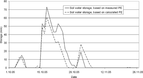
The general water budget in the rain-fed grasslands, which receive water from rainfall only and not from river spill, is negative, as shown in . Recharge in the observation period during which typical rainfall events were observed reaches values of 60–70 mm. The saturation level of 350 mm is not reached as the water evaporates between rain events. Temporary rainfall flooding to a shallow depth may occur locally in the rain-fed grasslands when strong rain events precipitate more water in a short time than can be infiltrated and then evaporated by the soil. Hurst & Phillips (Citation1938) have provided narrative evidence of such events.
Fig. 10 Soil water recharge in October and November 2005 based on rainfall data combined with measured and calculated evapotranspiration values. The point of soil saturation, 350 mm, is not reached. Rain received before October has already evaporated at this point. The discrepancy between the two curves can be explained by measurement problems.
The decline of floodwaters in the very shallow, widespread and densely vegetated seasonal flood plains has been investigated based on data collected during November 2005. Decreasing flood levels during this period have been measured, with an average of 5 mm/d. Water-level differences between the grasslands and the main swamps () show that the levels in the swamps are continuously higher than on the flooded plains. This observation indicates that no return flow of flood water occurs from the plains into the swamp and that evapotranspiration processes can be held responsible for the receding of the floods. Soil test results show that percolation can be neglected as a factor for losses, as, after soil has recharged its moisture deficit, the highly impermeable ground conditions of the area do not allow further losses to lower permeable layers.
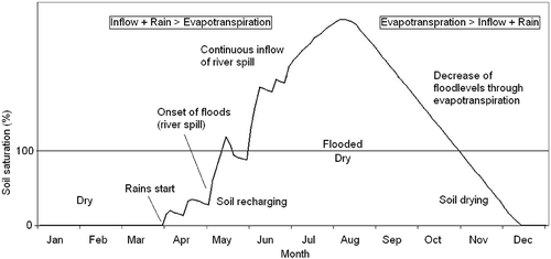
After the floodwaters have disappeared, evapotranspiration continues until soil moisture has dropped to a level where it cannot support vegetation growth any more. At this stage the grass is drying and eventually burns; the remaining water is evaporated by the soil. The indicative water budget for the river flooded grasslands is shown in . A more detailed assessment was not possible as the inflowing floodwaters were not gauged.
Fig. 11 Indicative water budget of the seasonal flooded grasslands (river-fed) during an annual flooding cycle.
CONCLUSIONS
The flooding and drying mechanisms of the toic area, the seasonal flooded grasslands of the Sudd swamps between Bor and Shambe, have been investigated. The findings show soil water recharge exceeding 350 mm and evapotranspiration of 2075 mm/year. Deep percolation can be excluded due to impermeable soil conditions. Soil water budget assessments show that the soil in the rain-fed areas, during normal rain events and conditions, does not reach its saturation point due to high evapotranspiration rates.
Floodwaters leading to permanent flooding originate from river spill, while rainfall may only cause temporary and shallow floods in exceptional circumstances during very intense rain events of the order of 77 mm/(10 min). Decreasing flood levels are caused by evapotranspiration processes, while return flow into the river is negligible for the larger parts of the flood plains. Water levels, which are higher in the swamps than on the flood plains, highlight the significance of evapotranspiration processes at all times. It can be assumed that the loss of waters with the resulting gradients leads to a continuous uni-directional flow from the swamps towards the grasslands, a mechanism which may be important for sediment and nutrient transport. For further assessments and calculation of the water balances of the flood plains, a two-dimensional numerical model assessment would be necessary to obtain a clear picture of the open swamp–flood plain boundary flows and respective quantitative assessments of system inflow.
Acknowledgements
Data for this work were partly collected through the South Sudan Road and Dike Rehabilitation Project (Hassan et al., Citation2006). John Sutcliffe's useful comments on a first draft and the support of the staff of the Department of Hydrology and Water Resources Management of the University of Kiel for the soil testing are acknowledged.
Related Research Data
REFERENCES
- Allen , R. G. , Pereira , L. S. , Raes , D. and Smith , M. 1998 . “ Crop evapotranspiration—guidelines for computing crop water requirements ” . In FAO Irrig. Drain. Paper 56 Rome, , Italy
- Butcher , A. D. 1938 . The Sadd Hydraulics , Cairo, Egypt : Government Press .
- DIN 11277 . 1994 . Soil quality: determination of particle size distribution in mineral soil material—method by sieving and sedimentation , Germany : DIN .
- DIN 18130 . 1998 . Soil: investigation and testing; determination of the coefficient of water permeability—Part 1 , Germany : Laboratory tests. DIN .
- Hassan , R. , Scholes , R. J. , Marneweck , G. , Petersen , G. , Mungatanga , E. , Wahungu , G. , Batchelor , A. , Thompson , M. , Rountree , M. , Lo-Liyoung , C. , Crosskey , S. , Ipoto , L. , Kuot , P. and Echessah , P. 2006 . Environmental impact assessment of the Bor Counties Dyke Rehabilitation Project , South Africa : CEEPA, Univ. of Pretoria .
- Hurst , H. E. 1933 . “ The Nile Basin, vol. IV and supplements 1–13 ” . In Ten Day Mean and Monthly Mean Discharges of the Nile and its Tributaries , Cairo, Egypt : Government Press .
- Hurst , H. E. and Phillips , P. 1931 . The Nile Basin, vol. I. General Description of the Basin, Meteorology, Topography of the White Nile Basin , Cairo, Egypt : Schindlers Press .
- Hurst , H. E. and Phillips , P. 1938 . The Nile Basin, vol. V. The Hydrology of the Lake Plateau and the Bahr el Jebel , Cairo, Egypt : Schindlers Press .
- Hurst , H. E. and Black , P. 1943 . “ The Nile Basin, vol. VI ” . In Monthly and Annual Rainfall Totals and the Number of Rainy Days at Stations in and near the Nile Basin , Cairo, Egypt : Schindlers Press . and supplements)
- IUSS Working Group WRB . World reference base for soil resources 2006 . World Soil Resources Report no. 103 . 2006 . FAO, Rome, Italy
- Jacobs , J. M. , Mergelsberg , S. L. , Lopera , A. F. and Myers , D. A. 2002 . Evapotranspiration from a wet prairie wetland under drought conditions: Paynes Prairie Reserve, Florida, USA . Wetlands , 22 ( 2 ) : 374 – 385 .
- JIT (Jonglei Investigation Team) . 1954 . The Equatorial Nile Project and its effects on the Anglo-Egyptian Sudan , Khartoum, Sudan : Sudan Government .
- Mefit-Babtie Srl . 1983 . Development Studies of the Jonglei Canal Area, Range Ecology , vol. 2 , Khartoum, Sudan : Survey, Final Report . Background
- Migahid , A. M. 1948 . Report on a botanical excursion to the Sudd region , Cairo, Egypt : Fouad University Press .
- Migahid , A. M. 1952 . Further observations on the flow and loss of water in the “Sudd” swamps of the upper Nile , Cairo, Egypt : Fouad University Press .
- Mohamed , Y. A. , Bastiaanssen , W. G. M. and Savenije , H. G. 2004 . Spatial variability of evaporation and moisture storage in the swamps of the upper Nile studied by remote sensing techniques . J. Hydrol , 289 : 145 – 164 .
- Mohamed , Y. A. 2005 . The Nile Hydroclimatology: Impact of the Sudd Wetland , Delft : Delft University of Technology .
- Penman , H. L. 1963 . Vegetation and Hydrology. Tech. Comm , Harpenden, , UK : no. 53, Commonwealth Bureau of Soils .
- Petersen , G. , Abya , J. A. and Fohrer , N. 2007 . Spatio-temporal water body and vegetation changes in the Nile swamps of southern Sudan . Adv. Geosci. , 11 : 113 – 116 .
- Petersen , G. , Sutcliffe , J. V. and Fohrer , N. 2008 . Morphological analysis of the Sudd region using land survey and remote sensing data . Earth Surface Processes Land , 33 ( 11 ) : 1709 – 1720 .
- Portoghese , I. , Iacobellis , V. and Sivapalan , M. 2008 . Analysis of soil and vegetation patterns in semi-arid Mediterranean landscapes by way of a conceptual water balance model . Hydrol. Earth Syst. Sci. , 12 : 899 – 911 .
- Schoeneberger , P. J. , Wysocki , D. A. , Benham , E. C. and Broderson , W. D. 2002 . Field Book for Describing and Sampling Soils. Version 2.0 , Lincoln, , USA : NRCS-NSSC .
- Sutcliffe , J. V. 1974 . A hydrological study of the southern Sudd region of the Upper Nile . Hydrol. Sci. Bull. , XIX ( 2 ) : 237 – 255 .
- Sutcliffe , J. V. and Parks , Y. P. 1999 . The Hydrology of the Nile. IAHS Special Publ. 5 , Wallingford, , UK : IAHS Press .