Abstract
Estimation of design storm rain depths of probable maximum precipitation (PMP) magnitudes over different zones of the Krishna basin, India, was attempted by using daily rainfall data of about 570 raingauge stations in and around the basin for a 102-year period (1901–2002). By considering the geographical location, orographic features and rainfall characteristics, the entire basin was divided into nine zones. Analysis of severe rainstorms over each zone was carried out and envelope rain depths (standard project storm, SPS, rain depths) over each zone were estimated. These SPS rain depths were then adjusted with moisture maximization factors (MMFs) of respective severe rainstorms to work out the PMP design rain depths. On the basis of available hourly data, average time distribution was also calculated. The study was carried out with the aim of estimating the requisite standard projects storms and probable maximum storms or PMP depths to derive the corresponding design flood estimates. This may serve as a convenient tool for design engineers, in the estimation of design storm rain depths for different sub-basins and the entire Krishna basin while constructing any hydraulic structure connected with irrigation, hydropower generation and flood control in the homogeneous region of the basin.
Citation Kulkarni, B. D., Nandargi, S. & Mulye, S. S. (2010) Zonal estimation of probable maximum precipitation rain depths over the Krishna basin in peninsular India. Hydrol. Sci. J. 55(1), 93–103.
Estimation zonale des hauteurs des précipitations maximales probables dans le bassin versant du Fleuve Krishna en Inde péninsulaire
Résumé L'estimation des hauteurs de précipitation maximales probables (PMP) d'averses de projet sur différentes zones du bassin versant du Fleuve Krishna, en Inde, a été tentée à partir des données pluviométriques d'environ 570 pluviomètres situés dans et autour du bassin pour une période de 102 ans (1901–2002). En tenant compte du positionnement géographique, des traits orographiques et des caractéristiques des pluies, la totalité du bassin versant a été divisée en neuf zones. L'analyse des fortes averses sur chaque zone a été faite et les hauteurs de pluie enveloppes (hauteurs de pluie de l'averse de projet standard, APS) ont été estimées pour les différentes zones. Les hauteurs de pluie d'APS ont ensuite été ajustées avec des facteurs de maximisation de l'humidité des fortes averses correspondantes afin de calculer les hauteurs des PMP. Sur la base des données horaires disponibles, la distribution temporelle moyenne a également été calculée. L'étude a été conduite avec l'objectif d'estimer les averses de projet standard et les averses maximales ou les hauteurs des PMP afin de déduire les estimations des crues de projet correspondantes. Ceci peut servir d'outil pour l'ingénierie de dimensionnement via l'estimation des hauteurs des pluies de projet pour différents sous-bassins et pour l'ensemble du bassin du Krishna, lors de la construction de tout ouvrage hydraulique en lien avec l'irrigation, l'hydro-électricité et la maîtrise des crues.
INTRODUCTION
Design storm studies are carried out to estimate the highest rain depth magnitudes in the form of standard project storms (SPS) and probable maximum precipitation (PMP) from the analysis of severe rainstorms, and to provide the time distribution for planning and design of hydraulic structures in major water resources projects for which no risks can be taken. In India, many studies are available regarding rainfall analysis over different regions of the country and over a few river basins up to certain dam sites only (Dhar et al., Citation1991; Kulkarni et al., Citation2005). However, detailed studies over an entire river basin and its different sub-basins/zones are lacking. Such studies are essential for planning and design of water resources projects which are connected with irrigation, water conservation and supply, hydropower generation, etc., particularly in the basin under study.
There are two major methods to obtain PMP: statistical estimation and by the meteorological (physical) method. The statistical procedure for estimating PMP is normally used whenever sufficient rainfall data are available, and is particularly useful for making quick estimates, or where other meteorological data, such as dew point, wind records, etc. are lacking. In many countries, the meteorological method is preferred, and this contains three steps: (a) maximization of storm data; (b) storm transposition; and (c) establishing the relationship among depth, area and duration. In short, the physical approach for estimating PMP over a river basin takes into consideration the physiographic conditions of the terrain, catchment characteristics and the moisture-holding capacity of the atmosphere during the movement of the particular weather system. Thus, in the present study, storm rainfall has been maximized to obtain PMP by using the following equation:
where P actual is actual measured rainfall; W max is the humidity of maximum dew-point temperature; and W actual is the humidity of dew-point temperature at the rainstorm area.
Thus, PMP analysis by the physical method includes comprehensive evaluations of extreme rainfall events, including storm analyses, storm maximization, storm transposition and storm aspect ratio and orientation evaluations. For this, all extreme rainfall storm events that have occurred over meteorologically and geographically similar regions are studied. However, the techniques used to estimate PMP design rain depths depend on the rainfall data available and may vary with catchment size and location, as well as with the meteorological conditions responsible for causing extreme rainfall over the catchments of interest.
OBJECTIVES
A large number of water resources projects have been carried out at different locations in the Krishna basin to store the volume of water that accumulates during the southwest monsoon months of June–September for use in hydropower generation and for irrigation needs. The spillway capacities of most of the existing dams/reservoirs were based on the then available techniques, and there is a great concern among water resources managers, such as the Central Water Commission (CWC), New Delhi, to revise the PMP design rain depths based on the latest techniques using all the available data. The objectives of this study are:
to evaluate PMP from historical heavy rainstorm data from 1901 to 2002 by using meteorological methods; | |||||
to obtain the depth–area–duration relationship of maximum precipitation; and | |||||
to work out grid-point PMP along with the contribution of each transposed storm applied across a grid that covers the entire Krishna basin. | |||||
PHYSIOGRAPHIC FEATURES OF THE KRISHNA BASIN
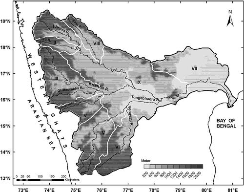
The Krishna River and its tributaries form an important integrated drainage system in the central portion of the Indian Peninsula. The Krishna River rises near Mahabaleshwar at 1360 m a.s.l. in the Western Ghats (Rao, 1975). After flowing eastwards from its origin for about 1400 km, it falls into the Bay of Bengal near Masullipatnam (). The drainage area of the entire basin is about 258 948.9 km2, of which 26.8% lies in Maharashtra, 43.8% in Karnataka and 29.4% in Andhra Pradesh. As per the Khosla (1949) classification, the entire basin has been divided into five sub-catchments (nos 306 to 310). However, in the present study, by considering the orography, geographic location and rainfall characteristics, the entire basin has been divided into nine zones (see ). Details of the nine zones and area covered under each zone are given in .
Table 1 Zones of the Krishna basin
Fig. 1 Orographic features and nine zones of the Krishna basin.
CLIMATOLOGICAL FEATURES OF THE KRISHNA BASIN
The Krishna basin is bounded on the west by the Western Ghats Mountains which exert a profound influence on rainfall over the basin. The southwest monsoon normally advances over the Krishna basin and adjoining areas by around the first week of June and establishes firmly over the entire basin by the end of June. It withdraws from this region in the second week of October. During the four monsoon months of June–September, different low-pressure systems, such as depressions and cyclonic storms originating in the Bay of Bengal, after crossing the Indian coast and moving in a westerly to northwesterly direction, generally cause heavy rainfall over the basin. On the basis of daily rainfall data from 321 stations within the Krishna basin, the mean annual rainfall over the entire basin has been calculated as being of the order of 90 cm; 74% of this falls during the southwest monsoon season. On average, about 25% of the annual rainfall is received during July alone.
DATA USED
Rainfall
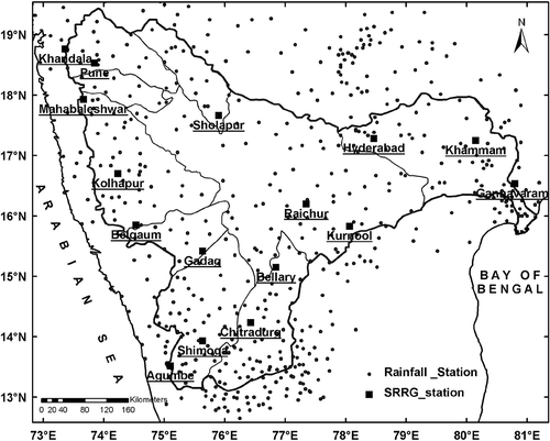
Daily rainfall data of about 570 stations in and around the Krishna basin (see ) for the period 1901–2002 have been used in the present analysis. These data were procured from: (a) the National Data Centre (NDC), India Meteorological Department (IMD), Pune, India; (b) rainfall data available with Indian Institute of Tropical Meteorology (IITM), Pune; (c) the Drought Monitoring Cell, Government of Karnataka, Bangalore; (d) the National Climate Data Centre (NCDC), NOAA, USA; and (e) the Water Resources Division, Maharashtra, India.
Fig. 2 Locations of rainfall and SRRG stations in and around the Krishna basin.
Self Recording Raingauge (SRRG) data
Hourly rainfall data of 16 SRRG stations (see ) from their available records for 1969 onwards were procured from NDC and IMD Pune, and used for time distribution analysis.
Dew-point temperature
Dew-point temperature data at 35 selected stations were collected from the Indian Daily Weather Report (IDWR), IMD Pune, for computation of the moisture maximization factor (MMF) of severe rainstorms.
METHODOLOGY
The determination of design storms involves comprehensive analyses of both synoptic extreme rainfall systems and smaller-scale Mesoscale Convective Complexes extreme rainfall storms. Thus the PMP study identifies significant extreme rainfall storm events. Considering the orography, nature and size of the Krishna basin, its sub-basins/zones, the amount of data available and its suitability, the PMP depths were estimated by the following three methods of rainstorm analysis:
the depth–duration (DD) method; | |||||
the depth–area–duration (DAD) method; and | |||||
the storm transposition (ST) technique | |||||
The above methods are well documented in various publications (cf. Wiesner, Citation1970; IMD, Citation1972; WMO, Citation1986). A brief description of these methods is given below.
Depth–duration (DD) method
In this method, the catchment is considered as a unit of study. All the heaviest rain spells (severe rainstorms) experienced by a basin over a long period of time are extracted and then analysed for different durations in order to obtain average maximum basin rain depths. The maximum rain depths thus obtained are plotted as DD curves and the highest rain depths are determined from the envelope curves. The envelope of all the rain depths, which is referred to as the design rain depth or standard project storm (SPS), is then determined for different durations. This method is normally used when daily rainfall data for a good network of stations are available for a sufficiently long period of years. The method is most suitable for the estimation of design rain depths over catchments located in mountainous regions or orographically influenced regions and also near coastal regions.
Depth–area–duration (DAD) method
Normally, the depth–area–duration (DAD) method is applied to those river basins whose boundaries are regular and smooth, but in many basins these conditions are not met. In this method of rainstorm analysis, the rainstorm is considered as a unit of study. The analysis is carried out to determine the highest precipitation amounts experienced over various size areas and durations in the rainstorm period. For each rainstorm, the area enclosed by the peripheral isohyet of the rainstorm is considered.
The rainstorms to be analysed by the DAD method are first determined by adding together the rainfall data of all the stations in the area affected by the rainstorm. The day with the highest total rainfall is considered as the maximum 1-day, the consecutive two days with the highest total rainfall is the maximum 2-day interval and so on. In this way, the maximum 1-day, 2-day and 3-day, etc., durations of the rainstorm are identified.
The rainfall values for different durations are then used to draw isolines at suitable intervals. A geographic information system (GIS) technique using the inverse-distance weighted method was used to measure the area bounded by each isoline. This method gives due consideration to the orientation of the topography of the region.
The average rain depths thus obtained are plotted against the accumulated area and a smooth envelope curve is drawn. The starting point is taken to be the central value of the rainstorm. The enveloping curve is known as the DAD curve of the rainstorm. Such DAD curves are plotted for all the severe rainstorms of different durations, separately. From these DAD curves the rainfall depth values are picked out for standard areas, such as 100, 300, 500, 1000, 2000, 5000, ……., 50 000 km2, for different durations. These values give the average rain depths over standard size areas measured outwards from the rainstorm centre. Such rain depths are used by design engineers to calculate unit hydrographs when constructing any hydraulic structure connected with irrigation, hydropower generation and flood control in the homogeneous region of the basin.
Storm transposition (ST) technique
The main purpose of rainstorm transposition is to increase the rainstorm experience of a basin by considering not only the rainstorms that have occurred over and near the basin in the past, but also those rainstorms which have resulted in heavy rainfall on adjacent areas that are meteorologically homogeneous. By using this technique, the historical rainstorms of the surrounding homogeneous regions are moved over the problem basin. The following minimum meteorological conditions for transposition need to be taken into account when transposing severe rainstorms over a problem basin:
the inflow direction of storms crossing the area should not vary excessively; | |||||
the air mass characteristics should be reasonably matching; | |||||
the area under consideration should be small enough that variation in latitude of storms tracks does not affect the distribution within the zone; and | |||||
the combination of rain producing mechanisms and associated synoptic situations should be the same. | |||||
The rainstorm transposition technique is generally applied to areas or basins which have a markedly irregular shape or peculiar orientation. Therefore, the following corrections need to be undertaken before applying this technique.
Barrier correction
In addition to the general decrease in rainfall with distance, an adjustment is required when there is a barrier or mountain range in the path of moist air being fed into the storm area. This is because the mountain range blocks off a certain fraction of the moist inflow into the storm area. The usual method (WMO, Citation1969) of allowing for the effect of a barrier is to reduce the rainfall value by the ratio of the precipitable water in a column of air above the height of the barrier to the total precipitable water extending to ground level on the windward side of the barrier, i.e.:
where R 1 is the adjusted rainfall value behind a barrier; R is the rainfall value not behind a barrier; W 1 is the precipitable water in a saturated pseudo-adiabatic atmosphere from the ground to a height corresponding to maximum surface dew point at the location of the storm; and W 2 is the precipitable water in a saturated pseudo-adiabatic atmosphere from the top of the barrier to the same height.
Topography adjustment
An adjustment of rainfall over a basin is necessary because of the presence of the topography. The orographic adjustment guidelines are given by WMO (Citation1986) as:
no change in rainfall for elevations up to 300 m; | |||||
increase the rainfall by 10% per 300 m of ascent above 300 m for the first upslope; and | |||||
in lee-side areas decrease the rainfall by 5% per 300 m of descent to the bottom of the valley. | |||||
Limits of transposition
Fixing limits to rainstorms for their transposition is one of the most important aspects in a design storm study. The following factors for determining the areal limits of transposition were suggested by WMO (Citation1970):
moisture source and barrier to moisture inflow for the rainstorm in situ; | |||||
accessibility to rainstorm moisture source and relative height of barrier to moisture inflow of other locations in the transposed zone; and | |||||
past occurrence of synoptic patterns similar to that of candidate rainstorms in features such as atmospheric moisture content and stability, wind direction and speed at surface and at higher levels, duration of pattern intensity, direction and speed of movement of low pressure centres at surface and higher level, etc. | |||||
As per WMO (Citation1986), transposition of a rainstorm is considered in 2° lat. × 2° long. grid cells over a study area located mainly in a plain region. The WMO recommends a coarse grid (depending upon topography) over flat areas and a fine one over the less flat areas.
ANALYSIS OF SEVERE RAINSTORMS
A rainstorm is defined as a spatial distribution of rainfall-yielding average depths of precipitation, which equal or exceed a certain specified threshold value over a river basin, in association with any meteorological phenomena. Considering the rainfall characteristics of the Krishna basin, a threshold value of about 10% of seasonal normal rainfall of each zone was considered for selection of severe rainstorms. shows the decadal distribution of the severe rainstorms that affected the Krishna basin during 1901–2002. The monthly frequency distribution of these severe rainstorms is shown in .
Fig. 3 Decadal distribution of severe rainstorms.
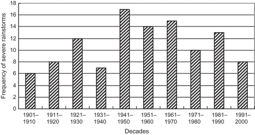
Fig. 4 Monthly frequency distribution of severe rainstorms.
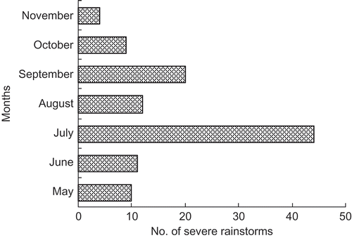
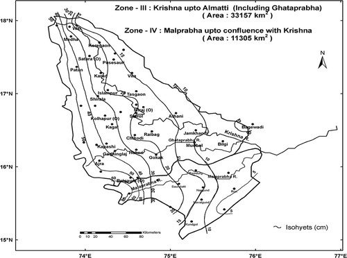
It is seen from and that the maximum number of severe rainstorms occurred during the 1941–1950 decade, whereas the occurrence of severe rainstorms is most frequent in the monsoon month of July. Examination of daily rainfall data also revealed that zones I, II, III, IV and VIII experienced the maximum number of severe rainstorms, compared to zones V, VI and VII. From these, the five most severe rainstorms were selected for further analysis. Analysis of all the selected severe rainstorms over the different zones of the Krishna basin was carried out by either the DD or DAD method (see Methodology Section), taking into consideration the orography and geographical location of each zone. The envelope average rain depths (SPS) over each of the zones I–VIII are given in . It is seen from this Table that the 4–6 August 1914 rainstorm contributed the highest areal average rain depths over zones III–IV. The 3-day isohyetal pattern of the 4–6 August 1914 rainstorm over these two zones is shown in .
Table 2 SPS and PMP design rain depths (cm) over zones I–VIII
Fig. 5 Three-day isohyetal pattern of the 4–6 August 1914 rainstorm over zones III and IV.
Dew-point data of about 35 stations in the moisture inflow path were collected during the severe rainstorms period to estimate the maximum moisture available during this period. Maximum moisture that could occur at the same time and location as the rainstorm on the basis of long-period dew-point data has been generated from the generalized maps prepared by Lal et al. (Citation2000). The MMFs of severe rainstorms which contributed SPS rain depths for zones I–VIII were estimated and are given in .
DAD analysis of severe rainstorm over Zone IX
Severe rainstorms that occurred over and near Zone IX, located over a plain region, during 1901–2002 were analysed by the DAD method, considering the rainstorm as a unit of study. The analysis revealed that the following nine severe rainstorms occurred over this region: (a) 30 October–1 November 1916; (b) 9–11 October 1933; (c) 23–25 May 1952; (d) 17–19 November 1952; (e) 21–23 September 1949; (f) 28–30 September 1964; (g) 13–15 July 1965; (h) 13–15 May 1979; and (i) 4–6 October 1994.
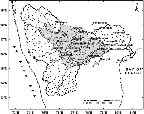
From the DAD analysis of the above rainstorms it was found that the rainstorms of September 1949, September 1964 and July 1965 were the three most severe rainstorms that occurred over the region and contributed greater rain depths for different size areas and durations. The DAD statistics of these rainstorms are given in . These three severe rainstorms were transposed over Zone IX in order to obtain the highest rain depths (SPS) over this zone and the results are given in . shows the isohyetal pattern of 20 September 1964 (1-day) in situ and the transposed isohyetal pattern of September 1964 over Zone IX is shown in . The MMFs of respective severe rainstorms were then adjusted with SPS rain depths to obtain PMP design rain depths by the physical method and the results are given in .
Table 3 DAD statistics of three severe rainstorms that occurred over and near Zone IX of the Krishna basin
Table 4 SPS and PMP rain depths of three severe rainstorms over Zone IX of the Krishna basin
Fig. 6 One-day isohyetal pattern of the 29 September 1964 rainstorm (in situ) over the Krishna basin.
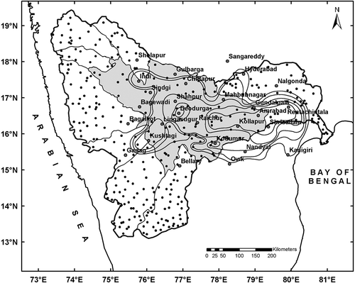
Fig. 7 Transposed isohyetal pattern of 1-day rainstorm of 29 September 1964 over Zone IX of the Krishna basin.
TIME DISTRIBUTION ANALYSIS
The time distribution of PMP design rain depths of 1-, 2-, 3-day duration over different, shorter intervals is required by the design engineers to compute probable maximum floods (PMF). Therefore, breaking down design storm rain depths into smaller intervals (e.g. 3, 6, 9, 12 h) specifies how the rainfall is distributed over successive shorter time intervals. Hourly rainfall data of 16 SRRG stations (see ) were used for the time distribution analysis of the Krishna basin. On the basis of this, heavy rain spells were selected at each of the 16 stations and the heaviest rainfall for different time intervals was estimated. The envelope average time distribution values thus obtained are given in .
Table 5 Envelope average (percentage) time distribution values over the Krishna basin
GRID-POINT MAXIMIZATION
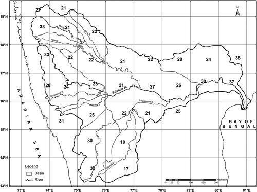
The severe rainstorms within each zone were considered for grid-point maximization. A grid system was constructed on a suitable base map of the study basin. For all the severe rain spells, gridded average rainfall series were prepared based on the severe rainstorms analysed. For the computation of PMP estimates in each grid cell, envelope rain depths contributed by severe rainstorms were subjected to moisture maximization factor (MMF) at their original locations. The MMFs thus obtained are applicable uniformly for all areas and durations of the storm rainfall. Envelope-gridded average rain depths over a grid cell then multiplied by the corresponding MMF yielded the maximized gridded average rain depths over that particular grid cell. Over Zone IX, severe rainstorms were transposed to have envelope average rain depths which were then used for computation of PMP following the above procedure. shows the 1-day PMP at different grid cells over the Krishna basin.
Fig. 8 One-day grid-cell PMP for the Krishna basin.
SUMMARY AND CONCLUSIONS
-
For the estimation of PMP, the Krishna basin in Peninsular India was divided into nine homogeneous zones.
-
Depth–duration analysis of severe rainstorms (1901–2002) was carried out over zones I–VIII, these zones having either an orographic influence or being located near the coast. Envelope rain depths (SPS) over each zone were maximized with respective MMFs of severe rainstorms to obtain PMP design rain depths. The PMP design rain depths for zones I–VIII ranged between 10.3–30.2, 11.3–26.3, and 13.0–34.7 cm, for 1-, 2- and 3-day duration, respectively. The highest PMP design rain depths were found to be over Zone IV (i.e. Krishna up to Almatti) and the lowest over Zone VII (i.e. Vedavati up to the confluence with Tungabhadra, being located in the rain shadow region).
-
Over Zone IX, located over the plain area of the basin, severe rainstorms were analysed by the DAD method. The storms of September 1949, September 1964 and July 1965 were found to be the most severe rainstorms. The PMP design rain depths estimated over Zone IX were of the order of 11.9, 19.0 and 21.8 cm for 1-, 2- and 3‐day duration, respectively.
The PMP design rain depths over different zones, and the time distribution analysis using hourly rainfall data detailed in this study will be useful for planning, management and design of water resources projects over the basin.
Acknowledgements
The authors are very grateful to Dr B. N. Goswami, Director, IITM, Pune, Dr G. B. Pant, Scientist-H, former Director, IITM and Principal Investigator of the CWC sponsored project, and Dr N. Singh, Scientist-F and Head of the Climatology and Hydrometeorology Division, IITM, Pune, for their constant encouragement and support for this study. The study is part of a project sponsored by the Hydrology Study Organization (HSO) of the Central Water Commission (CWC), New Delhi, Ministry of Water Resources, Govt of India. Thanks are also due to the Director General of Meteorology (DGM), India Meteorological Department and other organizations for supplying the relevant rainfall data for carrying out this study.
Related Research Data
REFERENCES
- Dhar , O. N. , Kulkarni , B. D. and Nandargi , S. S. 1991 . Design storm estimation for Wainganga basin up to Dhapewada dam site a brief appraisal . J. Appl. Hydrol. , 4 ( 1-2 ) : 43 – 49 .
- IMD (India Meteorological Department) . 1972 . Manual of Hydrometeorology , Pune, , India : Part I. IMD .
- Kulkarni , B. D , Mandal , B. N. , Mulye , S. S. and Deshpande , N. R. 2005 . Estimation of design storm for the Manjra Catchment . J. Appl. Hydrol. , 17 ( 2-3 ) : 52 – 59 .
- Lal , B. , Mehra , H. C. and Guha , K. B. 2000 . “ Generalized maps of 1-day point maximum persisting dew point temperature. IMD Met ” . In Monograph, Hydrology no. 13/2000, IMD, Pune India
- Mandal , B. N. , Deshpande , N. R. , Sangam , R. B. and Kulkarni , B. D. 2002 . Estimation of design storm rain depths for the Krishna catchment above Srisailam Dam . Proc. Int. Conf. on Hydrology and Watershed Management Jawaharlal Nehru Technical University (JNTU), Hyderabad, India, December 2002) , : 419 – 426 .
- Pant , G. B. , Mandal , B. N. , Deshpande , N. R. , Kulkarni , B. D. , Nandargi , S. S. , Sangam , R. B. , Mulye , S. S. , Prajapati , D. P. and Verma , A. K. 2007 . “ Generalized Probable Maximum Precipitation (PMP) Atlas of the Krishna basin ” . In Sponsored project from the Central Water Commission (CWC) , New Delhi : India .
- Rakhecha , P. R. , Deshpande , N. R. , Kulkarni , A. K. , Mandal , B. N. and Sangam , R. B. 1995 . Design storm studies for the Upper Krishna river catchment upstream of the Almatti dam site . Theoret. Appl. Clim. , 52 ( 3-4 ) : 219 – 229 .
- Schulze, O., Roth, R. & Pieper, O. (1994) Probable maximum precipitation in the Upper Harz Mountains. In: FRIEND: Flow Regimes from International Experimental and Network Data (ed. by P. Seuna, A. Gustard, N. W. Arnell & G. A. Cole) (Proc. Braunschweig Conf., August 1994), 315–321. IAHS Publ. 221, IAHS Press, Wallingford, UK. http://iahs.info/redbooks/221.htm
- Tomlinson, E. & Kappel, B. (1993) A project report on Statewide Probable Maximum Precipitation (PMP) Study for the State of Nebraska. appliedweatherassociates.com/West-Regional-ASDSO, Hydrometeorological Report no. 51, 1–12 http://appliedweatherassociates.com/West-Regional-ASDSO.pdf (Accessed: 2008 ).
- Walland, D., Meighen, J., Xuereb, K., Beesley, C. & Hoang, Tam (2003) Revision of the Generalised Tropical Storm method for estimating Probable Maximum Precipitation, HRS Report no. 8, Hydrometeorological Advisory Service, Hydrology Unit, Melbourne, Australia http://www.bom.gov.au/hydro/has (Accessed: 2007 ).
- Wiesner , C. J. 1970 . Hydrometeorology , London, , UK : Chapman & Hall .
- WMO (World Meteorological Organisation) . 1969 . Estimation of Maximum Floods , Switzerland : Tech. Note 98, WMO Publ. no. 233, WMO TP 126, Geneva .
- WMO (World Meteorological Organisation) . 1970 . Guide to Hydrometeorological Practices , Switzerland : Tech. note 168, WMO TP 82, Geneva .
- WMO (World Meteorological Organisation) . 1986 . “ Manual for estimation of probable maximum precipitation ” . In Operational Hydrology Report no. 1 (second edn). WMO Publ. 332, Geneva Switzerland