Abstract
Soil erosion vulnerability and extreme rainfall characteristics over the Mediterranean semi-arid region of Tunisia are crucial input for estimation of siltation rate in artificial reservoirs. A comprehensive high-resolution database on erosive rainfall, together with siltation records for 28 small reservoirs, were analysed for this region, the Tunisian Dorsal (the easternmost part of the Atlas Mountains). The general life-span of these reservoirs is only about 14 years. Depending on the soil degradation in the different catchments, the corresponding reservoirs display a wide range of soil erosion rates. The average soil loss was 14.5 t ha−1 year−1 but some catchments display values of up to 36.4 t ha−1 year−1. The maximum 15-min duration rainfall intensity was used to determine the spatial distribution of rainfall erosivity. The northwestern parts of the Tunisian Dorsal display the most extreme rainfall erosivity. Spatial erosion patterns are to some extent similar; however, they vary greatly according to their location in the “soil degradation cycle”. This cycle determines the soil particle delivery potential of the catchment. In general, the northwestern parts of the Dorsal display modest soil erosion patterns due to the already severely degraded soil structure. Here, the soil surface is often the original bedrock. However, the greatest soil erosion occurs in the mid-eastern parts of the Dorsal, which represents the “degradation front”. The latter corresponds to the area with highest erosion, which is continuously progressing westward in the Dorsal. The large variation between the erosive rainfall events and the annual soil loss rates was explained by two important factors. The first relates to the soil degradation cycle. The second factor corresponds to the degradation front with the highest soil loss rates. At present this front is located at 300 m altitude and appears to be moving along an 80-km westward path starting from the east coast. A better understanding of the above can be used to better manage soils and soil covers in the Tunisian Dorsal area and, eventually, to decrease the soil erosion and reservoir siltation risk.
Citation Jebari, S., Berndtsson, R., Bahri, A. & Boufaroua, M. (2010) Spatial soil loss risk and reservoir siltation in semi-arid Tunisia. Hydrol. Sci. J. 55(1), 121–137.
Analyse spatiale du risque de perte de sol et de l'envasement de réservoirs en Tunisie semi-aride
Résumé La vulnérabilité des sols à l'érosion et les caractéristiques des pluies extrêmes de la région Méditerranéenne semi-aride de la Tunisie sont des données cruciales pour estimer les taux d'envasement des réservoirs artificiels. Une base de données à haute résolution de pluies érosives et d'enregistrements d'envasement de 28 petits réservoirs a été analysée pour cette région, la Dorsale Tunisienne (à l'extrémité orientale de la chaîne de l'Atlas). La durée de vie de ces réservoirs est généralement limitée à environ 14 ans. Selon la dégradation des sols dans les différents bassins versants, les réservoirs présentent une large gamme de taux d';érosion des sols. La perte de sol moyenne est de 14.5 t ha−1 an−1 mais certains bassins présentent des valeurs atteignant 36.4 t ha−1 an−1. L'intensité de précipitation maximale en 15 minutes a été utilisée pour représenter la distribution spatiale de l'érosivité de la pluie. Les zones au nord-ouest de la Dorsale Tunisienne présentent l'érosivité de la pluie la plus extrême. Les schémas spatiaux d'érosion sont partiellement similaires. Ils varient cependant grandement selon leur position dans le “cycle de dégradation des sols”. Ce cycle détermine le potentiel d'exportation de particules de sol du bassin versant. En général, les zones au nord-ouest de la Dorsale présentent des schémas d'érosion modeste dus à la structure déjà sévèrement dégradée des sols. Ici, la surface des sols est souvent le substrat original. L'érosion la plus forte apparaît dans les zones moyen-orientales de la Dorsale qui représentent “le front de dégradation”. Il s'agit de la zone de plus forte érosion, qui progresse en permanence vers l'ouest de la Dorsale. L'écart important entre les événements pluvieux érosifs et les taux annuels de perte de sol est expliqué par deux facteurs importants. Le premier est lié au cycle de dégradation des sols. Le second correspond au front de dégradation avec les taux de perte de sol les plus forts. Actuellement ce front se situe à 300 m d'altitude et apparaît être mobile le long d'un chemin de 80 km vers l'ouest à partir de la côte orientale. Une meilleure compréhension de ces aspects pourrait servir à gérer les sols et les occupations du sol dans la région de la Dorsale Tunisienne, et éventuellement de réduire l'érosion des sols et le risque d'envasement des réservoirs.
INTRODUCTION
Soil erosion does not only cause serious environmental degradation but is also an important indicator of hydrological and climatic change (Sundborg, Citation1992; Tafangenyasha, Citation1997). Soil erosion leads to siltation, which is a major problem for lake and reservoir management all over the world (e.g. ILEC, Citation1993, Citation2003; UNEP, Citation1994; Keller et al., Citation2000). Reservoir siltation has direct negative economic and environmental consequences, since less water volume is available for irrigation, water supply and flood control. Recent research indicates that prediction of sediment yield is one of the main challenges in soil erosion research (Price et al., Citation2000; Coppus et al., Citation2002; De Vente, Citation2005; Herath, Citation1999; Goel et al., Citation2005). The climatic regions most vulnerable to soil loss are the semi-arid areas (Woodward, Citation1995; WCD, Citation2000) while the geographical area with the highest rate of siltation is Africa (on average about 19% of reservoir storage volume; ILEC, 1993, Citation2003; UNEP, Citation1994). During recent decades, research has emphasized the importance of soil erosion in the Mediterranean basin where siltation reduces reservoir capacity rapidly (e.g. Imeson, Citation1990; Poesen & Hooke, Citation1997; EEA, Citation2000; Martínez-Casasnovas et al., Citation2003). In this region, the water needs amount to close to the potentially available water resources (e.g. Ennabli et al., Citation1998), and water is becoming increasingly expensive and a heavy burden for the economy.
Tunisia was one of the countries within the Mediterranean basin classified among the first ten, worldwide, that would suffer from water scarcity (FAO, Citation1994). In 2006, 87% of potential surface water resources were utilized through reservoirs. The maximum water harvesting will reach 95% in 2010. Between now and 2030, the Tunisian reservoir capacity is expected to gradually decrease by 40 × 106 m3 per year due to siltation (GOPA & GTZ, Citation2005). In order to balance this capacity loss, various measures are being introduced. These measures include increasing dam heights and the construction of more small and average-sized reservoirs. In fact, more than 800 small reservoirs are being built in semi-arid Tunisia in rough natural conditions. They constitute one of the elements of the national policy of water resources mobilization and contribute to protection of the downstream zones, to control of water erosion, to groundwater replenishment and to improving the spatial distribution of the general water resource.
To mitigate siltation risks there is a great need to establish better relationships between the erosion process and exceptional rainfall event characteristics. Hence, the objective of this study is to examine the influence of short-term exceptional rainstorm intensity on erosion and reservoir siltation at small and large scales. The data used are from a unique high-resolution rainfall database, and siltation data from 28 reservoirs collected during an EU-funded project (IRD, Citation2000). By combining the two sources of data we aim at improving the understanding of the erosion processes and delineating important links between field rainfall characteristics and sediments deposited in small reservoirs. The results are based on local and spatially distributed observations. The latter use, respectively, “the soil degradation cycle” and the “degradation front” to display the soil loss dynamics and paths at the catchment and the regional scale. This will enable engineers to better estimate the probable life span of the reservoirs, to improve measures taken against reservoir sedimentation, and finally to address water shortage in a context of an increasing need for water.
DATA AND METHODS
Study area
The Tunisian Dorsal (the easternmost part of the Atlas mountain range) plays an important role in the hydrology of the country, since its mountain chain links the big wadis, e.g. Mejerda, Meliane, Nebhana, Merguellil and Zeroud (). The hydrological regime of this region has a hot dry summer of 4–5 months during which shallow groundwater may evaporate. Water resources are based on surface water use, and agriculture on cereal crops and cattle raising. The soil cover degradation that characterizes the Dorsal has led to much soil erosion leaving a thinner and more uneven soil cover that often exposes the underlying rock surface. Soil erosion is a serious problem throughout the Dorsal area. It has been estimated that 7% of the area is badly damaged by erosion and 70% of the area is moderately damaged. This degradation is an accumulated effect of agricultural strategies adopted over the Tunisian semi-arid areas during the last three millennia (Jebari et al., Citation2009). If we only consider short-term effects, the degradation can be partly attributed to the building of large dams during the 1960s and 1970s. This was done without giving sufficient attention to proper management of upper catchment areas. However, the contribution of the specific bioclimatic conditions of the Mediterranean climate in this degradation should not be underestimated. The soils are better characterized by the degradation of rock material rather than their organic matter content (Cerdan et al., Citation2004; Cudennec et al., Citation2007). Consequently, they are not well developed and often shallow. The young geological relief and the rate of erosion prevent them from reaching maturity. Also, the high potential evaporation rate causes formation of calcareous crusts at about 50 cm depth. The latter prevents water from seeping downwards and obstructs efficient drainage.
Fig. 1 Location of reservoirs in the Tunisian Dorsal area.
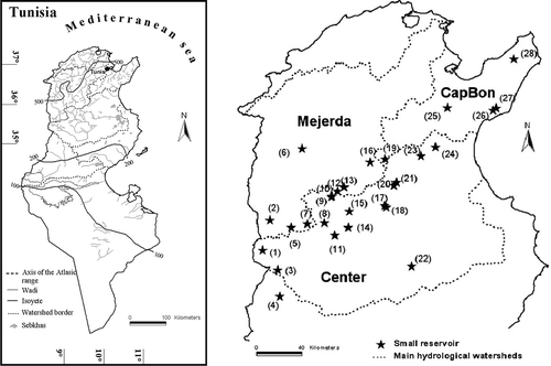
The Dorsal area is monitored by a hydrological observation network with 28 experimental catchments (). Each catchment discharges into a small reservoir. An automatic raingauge is located at each site as well as automatic water level recording.
Table 1 Physical and hydrological characteristics of studied catchments. Rainfall events correspond to 15-min duration maximum intensity (from Jebari et al., Citation2008)
Rainfall data and erosivity
In total, 28 rainfall gauges from the hydrological network were used in this study (). Missing data are less than 1% and the gauging density corresponds approximately to one gauge per 24 km2 catchment area. gives descriptive statistics for catchment characteristics and recorded erosive rainfall events during the analysed 10-year period (1993–2003). The raingauges are fully automatic and provide an accuracy of ±4% up to 250 mm/h intensity for a 5-min time step. The raingauges are of the tipping-bucket type and connected to a logger that records data every minute. A total of about 27 000 station rainfall events were included in the present analysis. A rainfall event was defined as separated from another event if a raingauge showed less than one tip per hour. The analysed period was compared to long-term rainfall conditions and the investigated period appears to be representative of longer periods. The mean annual rainfall for a longer period (1969–2003) was about 406 mm (standard deviation 124 mm). The same value for the period 1993–2003 was 365 mm (standard deviation 102 mm). Further details are given in Jebari et al. (Citation2008).
In this paper, a specific analysis is made regarding exceptional rainfall with an approximate return period equal to or longer than one year. We focus on rainfall with maximum intensities for a duration of 15 min. This duration was found representative regarding the erosion processes occurring in the monitored catchments (Jebari et al., Citation2008). About 500 station rainfall events of 15-min duration were included in the analysis. Each exceptional rainfall event is characterized by its depth, duration, average and maximum intensity, and its erosivity index (R). The latter is used in the Universal Soil Loss Equation (USLE; Wischmeier & Smith, Citation1978) developed to predict inter-rill and rill erosion. The R is based on the kinetic energy (KE) and the maximum intensity (I) during a 30-min period (Wischmeier & Smith, Citation1958; Lal, Citation1976).
Siltation observations
Siltation measurements were made on the basis of bathymetric observations in the reservoirs mentioned above.
Table 2 Reservoirs and observation of siltation
Table 3 Observation periods and data for reservoirs (for Mrira, Bouhaya, Jedeliane, and Baouejer the period of maximum soil loss could not be determined)
Catchment sediment yield is the amount of sediment delivered at the outlet of a catchment. It is used to design reservoirs and to analyse sedimentation and water quality problems. Moreover, it is an observation technique for estimating average water erosion for the catchment. Sediment yield is the sum of sediments produced by all erosive sources (Toy et al., Citation2002). In order to compare siltation rates for the different reservoirs, the deposited sediment volume on the bottom of the reservoirs was converted into transported mass of soil using an average of 1.5 t/m3 as an apparent density (Ben Mammou, Citation1998; and ).
Wischmeier & Smith (Citation1978) give the soil loss tolerance, defined as “the maximum level of soil erosion that will permit a level of crop productivity to be sustained economically and indefinitely” as 12 t ha−1 year−1. Experiments throughout the Tunisian semi-arid area have determined the average tolerable soil loss to about 2.5, 5 and 10 t ha−1 year−1 for a thin, average and thicker soil, respectively (Masson, Citation1972). With a very slow rate of soil formation in some parts of the Mediterranean region, any soil loss of more than 1 t ha−1 year−1 can be considered as irreversible within a time span of 50–100 years (EEA, Citation1999).
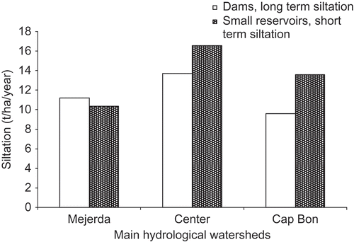
The representativeness of the study period versus long-term siltation conditions was evaluated. The longest and most reliable long-term measurement has been made in nine reservoirs belonging to the three most important catchments in semi-arid middle Tunisia. shows the mean annual soil loss during the period 1925–2004, which includes the study period, 1993–2003. The mean annual soil loss for the longer period was about 11.5 t ha−1 year−1. The same value for the study period was 13.5 t ha−1 year−1. This minor difference indicates that the 1993–2003 period was not exceptional in terms of average soil loss for the area.
Fig. 2 Long-term (1925–2004) soil loss as compared to soil loss during the study period (1993–2002).
Erosion process assumptions
Erosion processes are known to be variable within and between catchments (Campbell, Citation1992; Li et al., Citation2006). The three main types of water erosion are: inter-rill, rill and gully erosion. Inter-rill erosion concerns the uniform removal of soil and is assumed to be the first phase of the erosion process. Its rate is assumed to be low (Toy et al., Citation2002), but it affects the largest areas and has an essential role in the erosion system (EEA, Citation2002; Malam Issa et al., Citation2006). Rill erosion, presumably begins when inter-rill erosion reaches about 15 t ha−1 year−1 (Toy et al., Citation2002). Inter-rill and rill erosion account for about 40% of the sediment moving into the reservoirs in the Tunisian Dorsal (Plata Bedmar et al., Citation1997). Gully erosion, which is a localized process, supplies about 60% of total sediment yield to reservoir siltation (Plata Bedmar et al., Citation1997; Martínez-Casasnovas, Citation2003; Lesschen et al., Citation2007).
Extreme and exceptional rainfall events are known to be responsible for most of the soil erosion taking place in the Mediterranean areas (Boix-Fayos et al., Citation2007). They are characterized by short event duration (Weggel, Citation1992; Ramos et al., Citation1997; Cammeraat, Citation2002; EEA, Citation2002; Cerdan, Citation2004) and specific return period intervals (Bull et al., Citation1999; Hooke et al., Citation2000; Coppus et al., Citation2002; Garcia-Ruiz et al., Citation2003). Taking these features into account, erosive rainfall characteristics in semi-arid Tunisia were defined by Jebari et al. (Citation2008) relating the type of erosion to return period and intensity of maximum 15-min duration rainfall according to:
-
inter-rill erosion: 1 ≤ T < 5 corresponding to 38 ≤ I 15 < 65
-
rill erosion 5 ≤ T < 10 corresponding to 65 ≤ I 15 < 75; and
-
gully erosion: 10 ≤ T corresponding to 75 ≤ I 15.
METHODS
Reservoir sediments typically represent an important record of a catchment's erosion history. In fact, they provide information over relatively large time spans and so include the main exceptional erosive rainfall events responsible for erosion and siltation (e.g., Price et al., Citation2000; De Vente, Citation2005). From this point of view, the bathymetric measurements were used to estimate average and maximum siltation rates for each catchment ( and ). Average siltation rate was calculated using the first and the last bathymetric measurements of each reservoir. From these data, an annual average siltation was determined (). These calculations were performed for all reservoirs. To derive the maximum siltation rate in , the maximum siltation rate was selected from two successive bathymetric campaigns for a specific reservoir. However, for some reservoirs there was only a single bathymetric campaign. This was the case for the Mrira, Bou Haya, Baouejer and Jedeliane reservoirs (), for which the maximum siltation could not be determined. However, the average siltation rate could be determined using the storage volume just after construction of the reservoir. Using calculated siltation rates, average and maximum soil loss rates were computed for each catchment.
At the end of the 2006/07 hydrological year, the siltation state of the reservoirs was evaluated through field visits, and their average life span was deduced accordingly. The latter was compared to the average depreciation time for reservoirs or water harvesting structures. The average life span for such structures ranges from 20 to 40 years (Dendy et al., Citation1973; Khybri, Citation1985; Verma, Citation1987; Anonymous, Citation2000b; Goel et al., Citation2005). Thus, the erosive rainfall events that characterise the different siltation periods are especially important. Consequently, the dates related to the above bathymetric measurement periods (for average and maximum siltation) were used to identify the extreme rainfall events that occurred during these intervals. The maximum 15-min duration events were analysed in order to determine the resulting deposited sediment amount during the corresponding period. They were also used to determine the erosion process contribution to the soil loss rate for all catchments. The spatial distribution of erosive rainfall together with erosion processes were analysed for 22 catchments. Catchments that received specific erosion management and lacking maximum siltation values were discarded from the spatial analysis described below.
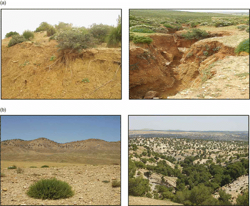
Since the surface conditions of the 28 catchments were carefully observed, and since they present a wide range of degradation stages (), the catchments were divided into degradation groups. Based on the degradation group, the life span of the reservoir can be better determined. These groups are also helpful in understanding the different siltation responses of catchments independently of climatic, physical and geographical conditions. The degradation grouping also allows a division into different vulnerability categories, depending on where each specific catchment is located in the soil degradation cycle. According to , the dominant landscape of the Tunisian Dorsal area is characterized by a soil surface horizon that is the original bedrock. This is noticeable at all spatial scales.
Fig. 3 Soil cover characteristics. Bedrock exposed at the surface at a small (a) and at a large scale (b) in the observation area.
The above experimental catchments were investigated through field trips and interviews with local farmers, inhabitants and water engineers. Catchments were characterized through their original bedrock (soft, hard; depth, etc.), their surface horizon aspect (rough, smooth, etc.), and erosion traces (rill and gully). Thus, catchments with similar degradation feature versus soil erosion rates could be grouped and compared to rainfall intensities. Once organised according to their erosion vulnerability, catchments could be clustered according to a typical “soil degradation cycle” spanning the entire Dorsal area. The procedure used for the catchments was also used at a larger scale for the entire Dorsal area. At this scale, the spatial distribution of rainfall intensities, erosion processes and the soil loss rates were used to define a “soil degradation front”. This front is considered as a degradation centre where erosion is at its maximum. Areas within the soil degradation front may potentially supply large loads of soil particles to downstream areas.
RESULTS AND DISCUSSION
Erosive event characteristics and soil loss rates
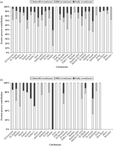
The erosive events may be linked to the three different types of erosion namely, inter-rill, rill, and gully erosion according to Jebari et al. (Citation2008). Based on these assumptions, the study area shows an average of 60 erosive events per year. They are unevenly distributed for different raingauge stations. The average erosive event was 2.2 per station and year. The average erosive event duration was 105 min, with a depth of 24.6 mm, a maximum intensity of 56 mm/h, and an average intensity of 23.5 mm/h. The total numbers of erosive events representing inter-rill, rill and gully erosion were 342, 84 and 65, respectively. The number of rainfall events related to the different erosion types varied depending on rainfall station ((a)). However, inter-rill rainfall events are present for all stations, while rill and gully rainfall events occur occasionally, depending on the year.
Fig. 4 Relative importance of erosion type depending on catchment. Catchments are listed according to location in the degradation cycle: (a) illustrates the average soil loss, and (b) the maximum soil loss.
In general, large variation was found between the erosive rainfall events and the annual average soil loss rate ((a) and ). The total number of erosive rainfall events during the 10-year observation period varied from 8 to 29, depending on station: eight erosive events at Arara and Barhim Zaher corresponding to an average siltation of 14 and 25 t ha−1 year−1; 17 erosive events at Abdeladim, Hadada and Abdessadok gave a siltation of 3.2, 11.2 and 15.9 t ha−1 year−1, respectively; 29 erosive events at Kamech and Ogla corresponding to 24.9 and 36.4 t ha−1 year−1, respectively. At stations such as Jedeliane and Mrichet, 20 erosive events gave the same siltation rate of 11.4 t ha−1 year−1. Similarly, for Dekikira and Mouidhi, 22 erosive events resulted in soil loss equal to 21 t ha−1 year−1. Notably, Ogla displayed the maximum average soil loss rate of all the studied reservoirs (). This station also had the largest number of erosive rainfall events per year (3.7).
(b) illustrates the maximum soil loss depending on catchment. All catchments had 91 recorded erosive rainfall events during the maximum soil loss periods. This corresponds to 68 inter-rill, 14 rill and nine gully erosion events. For these events, all stations except Saadine experienced inter-rill erosion. Nine stations experienced inter-rill erosion only ((b)). The observed soil loss during these events was 62.8, 49.5, 30.8 and 72.1 t ha−1 year−1 for Janet, Fidh Ali, Es-Senega and Dekikira, respectively (). This indicates how important the contribution from inter-rill erosion is to reservoir siltation throughout the Tunisian Dorsal area, in the absence of rill and gully erosion. Inter-rill erosion, together with a single rill event, displayed a maximum soil loss rate of 64.1 t ha−1 year−1 at Abdessadok. At Ogla, for two rill events, the maximum soil loss rate reached 88.3 t ha−1 year−1. These two rill events exceeded what was observed for inter-rill erosion alone. Joint inter-rill and rill erosion appears to be able to increase the maximum soil loss by more than 20 t ha−1 year−1, as compared to inter-rill erosion only (, and ). The Saadine catchment is subject to gully erosion ((b)) and had an average soil loss of 152.2 t ha−1 year−1 ()
The difference in values of average and maximum soil erosion is due to an increase in the annual erosive events by 9%. This is shown by an annual increase of inter-rill events by about 25% (33 events per year for the average soil loss and 41 events per year for the maximum soil loss period based on nine stations including Dekikira and Ogla). However, different responses for individual events may average out over longer periods of time. Examples are the Arara and Kamech catchments, situated to the west and east. Although they are very different in terms of physical properties and rainfall characteristics, they present an average similar soil loss of about 25 t ha−1 year−1 and a maximum siltation of about 50 t ha−1 year−1. The latter value is due to an exceptional 5-year return period event at Arara, and a 50-year return period event at El Kamech. In general, the number of erosive events per year shows a wide range of soil erosion rates. A larger number does not necessarily mean a greater soil erosion rate. It has to be remembered that each catchment has a specific response to the number and type of erosive rainfall events.
Soil loss rates and soil degradation cycle
The mean annual soil loss for all catchments was 14.5 t ha−1 year−1 (), while the maximum soil loss rate was 44.2 t ha−1 year−1 (). The mean values varied from 1.7 t ha−1 year−1 for El Gouazine Reservoir to 36.4 t ha−1 year−1 for El Ogla (). Among the 28 catchments studied, 17 display an annual soil loss of more than the permissible limit of 12 t ha−1 year−1 (Wischmeier & Smith, Citation1978; ). If we substitute Masson's (Citation1972) permissible limit for average soils (5 t ha−1 year−1), we find that 22 catchments are being seriously eroded. At the end of the hydrological year 2006/07, most reservoirs displayed rapid siltation. In fact, almost half of the reservoirs were already completely filled with silt. This occurred with an average reservoir life span of about 14 years. Referring to the depreciation time mentioned in the literature, the life time of Tunisian Dorsal reservoirs is well below average rates.
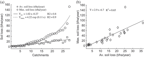
The observed siltation rates do not show any significant straightforward correlation with the different physical and hydrological features of the study catchments (). This result corroborates findings by Boufaroua et al. (Citation2006). In fact, that study showed a limited impact of topography, lithology, and even anthropogenic factors, for forecasting siltation for the Dorsal reservoirs. However, the distribution of average and maximum soil loss rates for all catchments arranged in an increasing order are shown in (a). The latter displays, respectively, a linear and an exponential distribution. (b) shows that there is a strong linear relationship between mean and maximum annual soil loss.
Fig. 5 (a) Distribution of average and maximum soil loss rates. (b) Average versus maximum soil loss. Catchments are arranged according to increasing values.
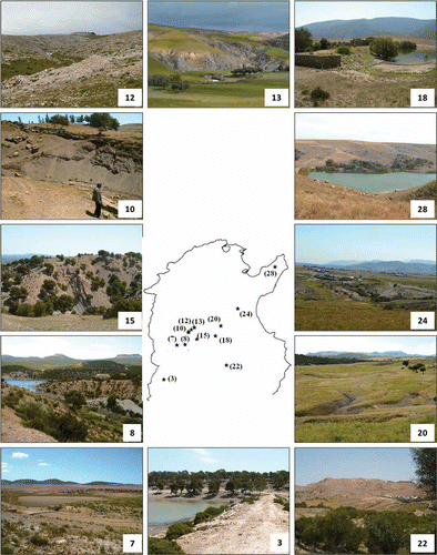
Knowing the soil degradation process for the different catchments is essential to understand the observed siltation rates. Catchments that are at the end of the soil degradation process, and thus display areas of bare bedrock, obviously yield small soil erosion rates. For example, the hard rocky upstream area of Hadada (11.2 t ha−1 year−1) displays an exhaustion of transported sediments, while Janet (26.8 t ha−1 year−1), with deeper and soft bedrock layers, shows great availability of transported soil particles. shows examples of soil surfaces from various parts of the Dorsal observation network. These photographs of the catchment landscapes tell much about the actual location in the soil degradation process and possible erosion rates. Examples are Arara, Echar and Abdeladim, with almost no gullies characterising the landscapes (), contrasting with Sadine 1, Dekikira and Saadine, showing a well developed gully network across their catchment areas ().
Fig. 6 The Tunisian Dorsal landscape in general and the experimental catchments in particular demonstrate different stages in the soil degradation cycle. Numbers correspond to catchments in
The predisposition and resistance of small catchments to soil loss depend on their ability to deliver soil particles. This ability is conditioned by the soil degradation cycle for each specific catchment. The degradation cycle can be described by three different catchment erosion states according to . The first state (Group I in ) refers to low soil loss rates and concerns catchments that are protected against rainfall erosivity by several parameters, such as erosion and soil restoration management practices. Two catchments, El Gouazine and Seghir, illustrate this first phase well and have low siltation rates (). Most of the soil surface in El Gouazine has been modified with soil contour ridges along the topographic contours in order to prevent runoff and erosion.
Fig. 7 Soil degradation cycles (I, II and III) depending on average and maximum soil loss rates. In the list to the right, stations are arranged according to their degradation levels as determined during field visits.
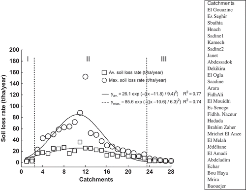
The second state corresponds to catchments that are more active in the degradation process because they have deeper soil layers and a soft bedrock (Group II in ). The catchments readily yield soil particles and the soil loss rate is large. Examples of this are Janet, Sadine 2, Kamech, Saadine and Dekikira, where the gully network is well developed. Actually, most of the catchments belong to this second state characterised by badlands.
The third state of the cycle includes catchments that are in their last stage of degradation (Group III in ). The majority of available soil particles have already been lost to downstream areas. The catchments display modest soil loss rates where the hard bedrock is uncovered. This last state is evident in a few catchments to varying degrees. Some examples are Bou Haya, Baouajer and Abdeladim. The last two catchments have soils with a calcareous crust at the surface.
Spatial erosive rainfall and soil erosion
Using the same assumptions regarding links between erosive rainfall intensity and soil erosion type, it is possible to delineate spatial properties of erosive rainfall and soil erosion. (a) shows the spatial distribution of erosive rainfall over the Dorsal area estimated from the maximum 15-min duration rainfall (1993–2003). The I 15 intensities increase anti-clockwise from the crest and slopes surrounding the mountain range at 300 m altitude and above. Below this level, I 15 takes the opposite direction. Therefore, the Dorsal area seems to be divided into an eastern and a western part around a specific centre. The latter, is located on the main Dorsal axis between the Saadine and Ogla stations. The eastern area includes the Cap Bon peninsula and corresponds to the northern end of the Dorsal chain. It is subject to northeastern disturbances which carry large amounts of moisture and are characterized by large variability and violent storms that can occur in all seasons (Rodier et al., Citation1981; Fons, Citation1987). The western parts are watered by northwestern disturbances which arrive in Tunisia filled with moisture and give rise to heavy rainfall (INM, Citation1993).
Fig. 8 (a) Spatial distribution of maximum 15-min duration rainfall intensity (1993–2003; Jebari et al., Citation2008), (b) (c) and (d) estimated number of annual events for different erosion types: inter-rill, rill, and gully erosion; (e) and (f) observed average and the maximum soil loss in t ha−1 year−1.
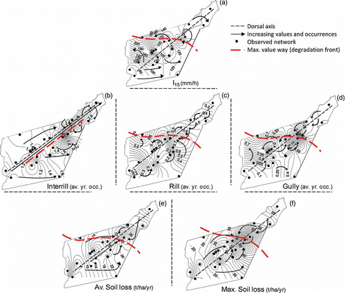
A comparison between the eastern and the western parts in terms of rainfall characteristics seems to be relevant for erosion dynamics. In fact, the eastern part experiences exceptional events that are 25% more recurrent, 40% more intense, 45% longer in duration and 28% more important in amount compared to conditions in the western part (). One of the reasons for this is that the eastern part does not present any significant physical barrier for rainfall. Catchment areas here are smaller (30%) presenting shorter concentration times (42%). Consequently, 30% and 40% more average and maximum soil loss, respectively, have been found ( and ). The eastern area also shows advanced degradation levels relative to the western area.
(b,c,d) shows the distribution of soil erosion risk expressed as the average number of erosive events per year based on the spatial pattern for I 15 ((a)). (e,f) shows the spatial distribution of observed soil erosion loss in t ha−1 year−1 calculated from the bathymetric data. The agreement between (b,c,d) and (a) is not perfect, at least not at the detailed level. However, the general agreement at a larger scale is quite striking. All estimated erosion types display a maximum near the northeastern or northwestern parts of the Dorsal. This is the same general pattern as for the observed erosion. The inter-rill risk map shows the largest values in the northeastern parts of the Dorsal, whereas the rill and the gully erosion risks appear to be the greatest in the northwest and central northeastern areas.
As seen from (e,f), the observed spatial average and maximum erosion is similar over the Dorsal area. The western part of the Dorsal displays the lowest erosion rates, while the mid-eastern parts have the highest rates. Consequently, there is a clear general trend in observed erosion along the Dorsal axis (broken line in ). The trend is increasing towards the mid-eastern Dorsal. The maximum erosion is observed for the Ogla–Saadine stations. These stations respectively present the most important difference in height (735 m) and the maximum observed soil loss for the whole network ( and ).
Some of the discrepancy between estimated and observed erosion rates depends on differences in the erosion cycle for the observed catchments. If all catchments had a similar soil surface, the observed erosion would probably have been closer to that estimated (from extreme rainfall).
From a large-scale perspective, the erosive processes and the availability of potential erosive material can be viewed as a slow moving “soil degradation front”. This soil degradation front coincides with the 300 m contour at the Ogla–Saadine transverse. It is continuously progressing westward, from lower to higher altitude, following the main axis of the Tunisian Dorsal. Consequently, the situation of catchments in the soil degradation cycle clearly displays the soil particle delivery potential for the Dorsal area. This then determines the progress of the soil degradation front as influenced by extreme rainfall.
The above findings are crucial to determine the areas where soil erosion control needs to be developed most urgently. For this, the main erosion type, exposure to extreme rainfall, degradation front direction, and the most vulnerable catchments within the degradation cycle need to be taken into account. For the Dorsal area it is clear that the 300 m altitude cross-section is an erosion front that needs to be closely monitored and further investigated. Similarly, areas surrounding the Dorsal ridge and areas at mid-slope locations are also necessary to monitor; all need urgent management to halt severe erosion.
CONCLUSIONS
The average soil loss for small semi-arid Tunisian catchments is 14.5 t ha−1 year−1. This induces rapid siltation of small reservoirs in the Tunisian Dorsal; they have a general life-span of only about 14 years. The maximum 15-min duration rainfall was seen to generate meaningful maps of erosion risks at large scales. These maps, together with information on the situation of a specific catchment in the soil degradation cycle, can be used to obtain a general idea of catchment erosion.
The northwestern part of the Dorsal displays the most extreme rainfall erosivity. Consequently, spatial erosion patterns are to some extent similar but are also greatly modified depending on their location in the soil degradation cycle. In general, the northwestern parts of the Dorsal display modest soil erosion patterns due to the already severely degraded soil structure. Their soil surface often consists of the hard original bedrock. The greatest soil erosion occurs in the mid-eastern parts of the Dorsal in catchments where deep vulnerable soils have only recently been exposed to severe erosion. In fact, the catchments are a part of the current degradation front of the Dorsal.
The mountain range provides soil particles from two main areas. The first area is the vulnerable catchments located in the second group within the soil degradation cycle. The second area corresponds to the degradation front currently located at about 300 m altitude. This front appears to be moving westward at a distance of more than 80 km perpendicular to the main Dorsal axis range.
The above results can be used for planning purposes to develop mitigation strategies for soil erosion management. At the small scale, such as the farm plot, the above approach is less useful due to the effect of local land-use and farming practices. At the larger scale, however, the results can be used to manage soils and soil covers better in the Dorsal area, and eventually to decrease the soil erosion and reservoir siltation risks.
Acknowledgements
Sihem Jebari and Akissa Bahri thank Mr Habib Farhat, head of the Tunisian Farmland Conservation and Management Department (DG/ACTA) for providing data and all his staff from Kasserine, Siliana, Kairouan, Zaghouan and Nabeul regional departments for valuable time and discussions allocated to this work. They also gratefully acknowledge Mr Ali Debabria for managing the field trips. Ronny Berndtsson was supported by the Swedish International Development Agency.
REFERENCES
- Anonymous . 2000b . Project Report of Panjara watershed under NWDPRA of Nurpur block in district Kangra of Himachal Pradesh , India : Department of Agriculture, Government of Himachal Pradesh .
- Ben Mammou , A. 1998 . “ Barrages Nebeur, Sidi Salem, Sidi Saad, et Sidi Bou Baker. Quantification, étude sédimentologique et géotechnique des sédiments piégés ” . In Apport des images satellitaires , Thèse de Doctorat Es-Sciences géologiques, Université de Tunis II, Faculté des Sciences de Tunis .
- Boix-Fayos , C. , Martinez-Mena , M. , Calvo-Cases , A. , Arnau-Rosalén , E. , Albaladejo , J. and Castillo , V. 2007 . Causes and underlying processes of measurement variability in field erosion plots in Mediterranean conditions . Earth Surf. Process. Landf. , 32 : 85 – 101 .
- Boufaroua , M. , Lamachère , J. M. , Débabria , A. and Ksibi , F. Prédétermination de l'envasement des lacs collinaires de la Dorsale Tunisienne . Proc. 14ème Conférence de l'ISCO . Mai, Marrakech, Maroc. pp. 14 – 19 .
- Bull , L. J. , Kirkby , M. J. , Shannon , J. and Hooke , J. M. 1999 . The impact of rainstorms on floods in ephemeral channels in southeast Spain . Catena , 38 : 191 – 209 .
- Cammeraat , L. H. 2002 . A review of two strongly contrasting geomorphological systems within the context of scale . Earth Surf. Process. Landf. , 27 : 1201 – 1222 .
- Campbell , I. A. 1992 . “ Spatial and temporal variations in erosion and sediment yield ” . In Erosion and Sediment Transport Monitoring Programmes in River Basins , Edited by: Bogen , J. , Walling , D. E. and Day , T. 455 – 465 . Wallingford, , UK : IAHS Publ. 210. IAHS Press . Proc. Oslo Symp., 24–28 August 1992
- Camus , H. , Guiguen , N. , Ben and Younes , M. 1995 . “ Note sur l'envasement de lacs collinaires en zone semi-aride tunisienne ” . In Rapport publié par la Direction de la Conservation des Eaux et du Sol & l'Institut de Recherche pour le Développement en Cooperation (Orstom) France
- Cerdan , O. , Le Bissonnais , Y. , Govers , G. , Lecomte , V. , Van Oost , K. , Couturier , A. , King , C. and Dubreuil , N. 2004 . Scale effect on runoff from experimental plots to catchments in agricultural areas in Normandy . J. Hydrol. , 299 : 4 – 14 .
- Coppus , R. and Imeson , A. C. 2002 . Extreme events controlling erosion and sediment transport in a semi-arid sub-Andean valley . Earth Surf. Process. Landf. , 27 : 1365 – 1375 .
- Cudennec , C. , Leduc , C. and Koutsoyiannis , D. 2007 . Dryland hydrology in Mediterranean regions—a review . Hydrol. Sci. J. , 52 ( 6 ) : 1077 – 1087 .
- DCES/IRD . 1994–2002 . Annuaires hydrologiques des lacs collinaires. Rapports publiés par la Direction Générale de l'Aménagement et de la Conservation des Terres Agricoles & l'Institut de Recherche pour le Développement , République Tunisienne .
- Dendy , F. E. , Champion , W. A. and Wilson , R. B. 1973 . “ Reservoir sedimentation surveys in the United States ” . In Man-made Lakes: Their Problems and Environmental Effects , Edited by: Ackermann , W. C. , White , G. F. and Worthington , E. B. 349 – 357 . Washington, DC, , USA : Geophysical Monograph 17, American Geophysical Union .
- De Vente , J. , Poesen , J. and Verstraeten , G. 2005 . The application of semi-quantitative methods and reservoir sedimentation rates for the prediction of basin sediment yield in Spain . J. Hydrol. , 305 : 63 – 86 .
- EEA (European Environmental Agency) . 1999 . Environment in the European Union at the turn of the Century . European Environmental Agency. ,
- EEA (European Environmental Agency) . 2000 . Down to earth: Soil degradation and sustainable development in Europe . Environmental issue series no. 16, European Environmental Agency. ,
- EEA . 2002 . Assessment and reporting on soil erosion. Background and workshop report. European Environmental Agency .
- Ennabli , M. , Margat , M. and Vallee , D. Pour prévenir les crises de l'eau en Méditerranée, priorité à une meilleure maîtrise des demandes . Proc. Conf. Int. “Eau et Développement durable” . Paris. pp. 19 – 21 . Mars
- FAO . 1994 . Situation mondiale de l'alimentation et de l'agriculture 1993. FAO Agriculture no. 26 , Rome, Italy : Food and Agriculture Organization of the United Nations .
- Fons , C. 1987 . Météo marine , 01 – 68 . Les dossiers des éditions du Pen-duick .
- García-Ruiz , J. M. , Martí-Bono , C. , Lorente , A. and Begería , S. 2003 . Geomorphological consequences of frequent and infrequent rainfall and hydrological events in Pyrenees Mountains of Spain . Mitigation and Adaptation Strategies for Global Change , 7 : 303 – 320 .
- Goel , A. K. and Kumar , R. 2005 . Economic analysis of water harvesting in a mountainous watershed in India . Agric. Water Manage. , 71 : 257 – 266 .
- GOPA and GTZ . 2005 . Elaboration d'une stratégie nationale d'adaptation de l'agriculture tunisienne et des écosystèmes aux changements climatiques , Pré rapport 1ere phase .
- Herath , M. G. and Gopalakrishnan , C. 1999 . The Economics of reservoir sedimentation: a case study of Mahaweli Reservoirs in Sri Lanka . Int. J. Water Resour. Devel. , 15 : 511 – 526 .
- Hooke , J. M. and Mant , J. M. 2000 . Geomorphological impacts of a flood event on ephemeral channels in SE Spain . Geomorphol. , 34 : 163 – 180 .
- ILEC and UNEP . 2003 . “ World lake vision—a call to action ” . In International Lake Environement Committee Foundation, and United Nations Environment Programme Nairobi, , Kenya
- ILEC and Lake Biwa Research Institute . 1988–1993 . Survey of the State of World Lakes , Vol. I–V , Kenya : ILEC/UNEP, Kusatsu/Nairobi .
- Imeson , A. C. 1990 . Climate fluctuations and soil erosion under Mediterranean conditions , Valencia, , Spain : Technical Report, Menéndez Pelayo Int. Univ .
- INM . 1993 . Pluies et nuages convectifs. Unité de recherche et de developpement , Tunisie : Rapport Interne de l'Institut National de la Météorologie .
- IRD . 2000 . Evaluation du programme lacs et barrages collinaires en Tunisie “Hydromed” , IRD, , France : Report published by l'Institut de Recherche et Developpement .
- Jebari , S. , Berndtsson , R. , Bahri , A. and Boufaroua , M. 2008 . Exceptional rainfall characteristics related to erosion risk in semiarid Tunisia . The Open Hydrol. J. , 2 : 1 – 9 .
- Jebari , S. , Berndtsson , R. , Lebdi , F. and Bahri , A. 2009 . Temporal aspects of soil erosion in Tunisia. (Manuscript) ,
- Keller , A. , Sakthivadivel , R. and Seckler , D. 2000 . Water scarcity and the role of storage in development , Colombo, , Sri Lanka : IWMI Research Report 39, International Water Management Institute .
- Khybri , M. L. 1985 . “ Experiences of the transfer of technology in soil and water conservation programme ” . In Proc. National Seminar on Soil and Water Conservation and Watershed Management 299 – 304 . New Delhi 17–18 September 1985
- Kirpich , Z. P. 1940 . Time of concentration of small agricultural watersheds . Civil Engng , 10 ( 6 ) : 362
- Lal , R. 1976 . Soil erosion problems on alfisols in western Nigeria and their control. IITA Monograph 1 , Ibadan, Nigeria : IITA .
- Lesschen , J. P. , Kok , K. , Verburg , P. H. and Cammeraat , L. H. 2007 . Identification of vulnerable areas for gully erosion under different scenarios of land abandonment in southeast Spain . Catena , 71 : 110 – 121 .
- Li , M. , Li , Z. B. , Ding , W. F. , Liu , P. L. and Yao , W. Y. 2006 . Using rare earth element tracers and neutron activation analysis to study rill erosion process . Appl. Radiation and Isotopes , 64 : 402 – 408 .
- Malam Issa , O. , Le Bissonnais , Y. , Planchon , O. , Favis-Mortlock , D. , Silvera , N. and Wainwright , J. 2006 . Soil detachment and transport on field- and laboratory-scale interrill areas: erosion processes and the size-selectivity of eroded sediment . Earth Surf. Process. Landf. , 31 : 929 – 939 .
- Martínez-Casasnovas , J. A. 1998 . “ Soil – landscape – erosion. Gully erosion in the Alt Penede`s-Anoia (Catalonia, Spain) ” . In A spatial information technology approach: spatial databases, GIS and remote sensing , Lleida, , Spain : PhD Thesis, University of Lleida .
- Martínez-Casasnovas , J. A. 2003 . A spatial information technology approach for the mapping and quantification of gully erosion . Catena , 50 : 293 – 308 .
- Masson , J. M. 1972 . L'érosion des sols par l'eau en climat Méditerranéen. Méthodes expérimentales pour l'étude des quantités érodées a l'échelle du champ . La Houille Blanche , 8 : 673 – 679 .
- Plata Bedmar , A. , Cobo Rayan , R. , Sanz Montero , E. , Gómez Montaña , J. L. and Avendaño Salas , C. 1997 . “ Influence of the Puentes Reservoir operation procedure on the sediment accumulation rate between 1954–1994 ” . In Proc. 19th Congress Grands Barrages , 835 – 847 . Florence, , Italy : Commission Internationale des Grands Barrages . Q. 74, R. 52
- Poesen , J. W. A and Hooke , J. M. 1997 . Erosion, flooding and channel management in the Mediterranean environments of southern Europe . Prog. Phys. Geogr. , 21 : 157 – 199 .
- Price , L. E. , Fawcett , C. P. and Young , P. C. 2000 . Modelling reservoir sedimentation and estimating historical deposition rates using a data-based mechanistic (DBM) approach . Hydrol. Sci. J. , 45 : 237 – 248 .
- Ramos , M. C. and Nacci , S. 1997 . Estabilidad de agregados superficales en suelos del Anoia-penedès (Barcelona) frente al humedecimiento y al impacto de las gotas de lluvia . Edafologia , 3 : 3 – 12 .
- Rodier , J. A. , Colombani , J. , Claude , J. and Kallel , R. 1981 . Le bassin de la Medjerdha , Paris, , France : Monographie de L'Orstom .
- Sundborg , A. 1992 . Lake and reservoir sedimentation prediction and interpretation . Geografiska Annaler, Series A, Phys. Geogr. , 74 : 93 – 100 .
- Tafangenyasha , C. 1997 . Should Benji Dam be dredged? A preliminary impact assessment to dredging a water reservoir in an African national park . Environmentalist , 17 : 191 – 195 .
- Toy , J. T. , Foster , G. R. and Renard , K. G. 2002 . Soil Erosion: Processes, Prediction, Measurement and Control , New York, , USA : John Wiley & Sons, Inc .
- UNEP . 1994 . The pollution of lakes and reservoirs (UNEP Environment Library) , Kenya : UNEP/Nairobi .
- Verma , H. N. 1987 . Studies of an efficient use of rainwater for rainfed crops , New Delhi, , India : Ph.D Thesis, Division of Agricultural Engineering. IARI .
- Weggel , J. R. and Rustom , R. 1992 . Soil erosion by rainfall and runoff—state of the art . Geotextiles and Geomembranes , 11 : 551 – 572 .
- WCD (World Commission on Dams) . 2000 . Dams and Development. A New Framework for Decision-Making , UK : Earthscan .
- Wischmeier , W. H. and Smith , D. D. 1958 . Rainfall energy and its relationship to soil loss . Trans. Am. Geophys. Union , 39 : 285 – 291 .
- Wischmeier , W. H. and Smith , D. D. 1978 . “ Predicting rainfall erosion losses ” . In A guide to conservation planning , Washington, DC, , USA : USDA Agriculture Handbook 537 .
- Woodward , J. C. 1995 . “ Patterns of erosion and suspended sediment yield in Mediterranean river basins ” . In Sediment and Water Quality in River Catchments , Edited by: Foster , I. D. L. , Gurnell , A. M. and Webb , B. W. 365 – 389 . Chichester, , UK : John Wiley & Sons .