Abstract
Mediterranean rivers are characterized by the irregularity of flow, harsh hydrological fluctuations and a profound transformation as the result of human activity. In this study, we investigate the streamflow response of a Mediterranean temporary river in which different groundwater, agriculture and urban contributions play an important role. Streamflow was measured at three nested gauging stations installed along Na Borges River, a lowland agricultural catchment (319 km2) on the island of Mallorca. Based on two hydrological years (2004/05 and 2005/06), potential evapotranspiration and surface water–groundwater interaction generated a succession of four different hydrological periods playing an important role in baseflow dynamics. The runoff coefficients were very low (<5%). At the event scale, groundwater also controlled runoff response, being very different according to hydrogeology, antecedent conditions and human impacts. During dry seasons, wastewater and karstic spring discharges maintain an influent regime into some streams. As a result, intense rainstorms in late summer generated water volumes over the impervious urban surfaces involved, with the result that quickflow was significant because the hydrological pathways were active. Footnote
Citation Estrany, J., Garcia, C. & Alberich, R. (Citation2010) Streamflow dynamics in a Mediterranean temporary river. Hydrol. Sci. J. 55(5), 717–736.
Résumé
Les rivières Méditerranéennes sont caractérisées par l'irrégularité des écoulements, de fortes fluctuations hydrologiques et une transformation profonde résultant des activités humaines. Dans ce travail, nous étudions la réponse en termes d’écoulement d'une rivière Méditerranéenne temporaire vis-à-vis de laquelle les contributions hydrogéologique, agricole et urbaine jouent un rôle important. Le débit a été mesuré en trois stations de jaugeage emboîtées le long de la Rivière Na Borges, présentant un bassin versant agricole de plaine (319 km2), dans l’île de Majorque. Sur la base de deux années hydrologiques (2004/05 et 2005/06), l’évapotranspiration potentielle et les interactions entre les eaux superficielles et souterraines ont produit une succession de quatre périodes hydrologiques différenciées, jouant un rôle important dans la dynamique du débit de base. Les coefficients d’écoulement sont très bas (<5%). A échelle de l’événement, les eaux souterraines contrôlent aussi l’écoulement superficiel, de manière très variable selon l'hydrogéologie, les conditions antérieures et les impacts anthropiques. Pendant les saisons sèches, les eaux usées et les résurgences karstiques maintiennent un régime influent dans certains cours d'eau. Par conséquent, les orages intenses de fin d’été générent des volumes d'eau sur les surfaces urbaines imperméabilisées concernées, impliquant des écoulements rapides significatifs car les circulations hydrologiques sont actives.
1. INTRODUCTION
Mediterranean rivers are characterized by the irregularity of flow and harsh hydrological fluctuations (Wainwright & Thornes, Citation2004). The climate variability is the main factor which states this irregularity of flow. Thus, they are similar to arid-climate rivers in terms of their high flow irregularity. However, higher precipitation (P) amounts make them similar to temperate-climate rivers. A second factor of irregularity is that significant areas of the Mediterranean basin are covered by karst (cavernous) or porous terrains formed in carbonate rocks (Macklin et al., Citation1995; Tzoraki & Nikolaidis, Citation2007). Although it has been demonstrated that the effects of groundwater can be observed in other river types (Keller & Kondolf, Citation1990), karst and porous terrains significantly contribute to the fact that streams are groundwater-dominated (White, Citation2002). It must also be considered that the extreme seasonal and inter-annual variability of the Mediterranean flow regimes often causes a marked pattern of zero or low flow. Therefore, depending on the degree of temporality, Mediterranean rivers can be classified either as perennial (continuous flow) or temporary (seasonal flow). The latter are subdivided according to their dry-period condition and to their discharge regime: ephemeral streams are influent, feeding the groundwater and having channels which are above the water table in all the time of the year, whereas the intermittent Mediterranean ones are only seasonally influent (Gallart et al., Citation2008). In addition to the “temporariness” of rivers, Mediterranean environments have also undergone a profound transformation as the result of human activity (Syvitski, Citation2003). Historically, human pressure on Mediterranean catchments has transformed the landscape clearing fields for agriculture (Grove, Citation1996) and implementing water evacuation practices which favour flow to rivers (Estrany et al., Citation2010). Recently, industrialization and pressure from tourism activities during the 20th century have led to important socioeconomic changes in rural areas, increasing urbanized surfaces and exploiting the aquifers (Pons-Esteva, Citation2000; Garcia & Servera, Citation2003). Urbanization, with the accompanying loss of vegetation, replacement of soil with impervious surfaces, and the routing of stormwater runoff directly to stream channels, has a significant impact on many of the processes that control streamflow.
Although hydrographs provide the only information available, the basis of hydrological processes active in a catchment cannot be identified, as different combinations of processes may lead to similar hydrographs. Despite this limitations (Hewlett, Citation1982), their study and runoff volumes (essentially quickflow volume, resulting from any hydrograph separation technique) has been a classic approach in catchment hydrology for several decades allowing to find the relationships between the response at the outlet and other hydrological information available in the catchment (Woodruff & Hewlett, Citation1970).
This study examines the runoff (R) and its components (baseflow and quickflow) measured at three nested gauging stations installed along Na Borges River over two hydrological years (2004/05 and 2005/06). The overall objective is to investigate the hydrological response of a Mediterranean temporary river where different groundwater, agriculture and urban contributions play an important role in streamflow variation. To achieve our objective, we (a) carried out a quantitative analysis of annual and seasonal precipitation, runoff, evapotranspiration (ET) and potential evapotranspiration (PET) by means of a simple water balance; (b) derived runoff components and several related indices to evaluate the frequency and variability of the hydrological response on annual and seasonal scales; and, finally, (c) examined baseflow and quickflow dynamics at the event scale by applying match-strip and stepwise multiple regression methods, respectively.
2. MATERIALS AND METHODS
2.1 Study area
The Na Borges catchment extends over the northeast of Mallorca and is the second largest catchment on the island, encompassing an area of 319 km2 (). Altitudes range from 300 to 500 m in upstream areas, where the average slope of tributary streams is 8%. Downstream, the main channel follows a very gentle average slope (0.29%) along the 26.8 km distance to the sea outlet.
Fig. 1 (a) The Na Borges catchment and its location in Mallorca; (b) the relief units defined by hydrogeology and geomorphology; and (c) geological cross-section. Upper maps show: (1) Mallorca location in the western Mediterranean, and (2) the location of the Na Borges catchment.
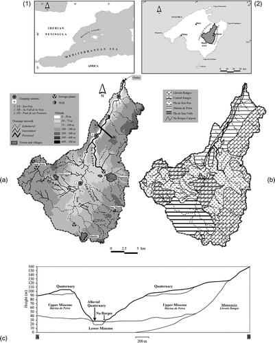
The geology and geomorphology of Na Borges are characterized by five relief units (): the Central and Llevant ranges, respectively, are characterized by structurally Alpine relief composed of Mesozoic limestones; the Pla de Son Pou is a flat depression composed of Quaternary alluvial sediments supported on an impervious Lower-Middle Miocene layer; the Marina de Petra and the Pla de Son Valls are reefal Upper Miocene tabular platforms composed of calcarenites and calcisiltites; and the Na Borges Canyon incises the Marina de Petra along NE–SW striking faults occupying the last 17.4 km of the main channel with an incision of more than 100 m depth ().
The surface water–groundwater interaction is initially determined by hydrogeological and geomorphological characteristics, and transformed by several human impacts. Therefore, different streamflow regimes can be observed in the catchment:
| a. | The tributaries that drain the Central and Llevant ranges are ephemeral because the high degree of fracturing, fissuring and karstification of Mesozoic limestones favours percolation (coefficient of approx. 15%) (Govern de les Illes Balears, Citation1999) through karstic perched aquifers not connected to channels. | ||||
| b. | The impervious sediments of the Pla de Son Pou do not allow the percolation into deep aquifers. Uniquely, a shallow and unconfined aquifer is built in the soils characterized by a high field capacity >40% (see Diaz Palmer et al., Citation2006), where the installation of a subsurface-tile drainage system is the only way to drain these areas (see Estrany et al., Citation2010). Therefore, these perched water tables, which naturally had formed wetlands, have enhanced streamflow to the Na Borges River since Roman times, resulting in an intermittent regime. | ||||
| c. | The calcarenites of the Marina de Petra constitute a karstic aquifer connected to the Na Borges River, characterized by high percolation coefficients (approx. 20% of P) and significant transmissivity >30 000 m2 d-1 (Govern de les Illes Balears, Citation1999). Thus, the first 5 km of Na Borges Canyon presents a perennial regime with an influent discharge fed by karstic springs and supported on fine silt Quaternary alluvial sediments of flood plain developed in the impervious Lower-Middle Miocene layer (). Downstream, fine silt Quaternary alluvial sediments are present but the impervious Lower-Middle Miocene is progressively substituted by pervious middle-upper Miocene calcarenites. Consequently, transmission losses occur progressively along the remaining 12 km of Na Borges Canyon, where different degrees of intermittency are recorded in accordance with the aforementioned lithological changes and dominant hydrometeorological conditions in the Mediterranean area. | ||||
| d. | The Pla de Son Valls is also characterized by high percolation and transmissivity, but the karstic aquifer is not connected to the channels, so that surface water flow from the Son Caules and Son Proenç tributaries was totally infiltrated and did not reach the main channel during the study period. The mean annual discharge (1970–1990) at Sa Vall de la Nou (264 km2) is 0.097 m-3 s-1. | ||||
The climate of Na Borges is classified as Mediterranean. The mean annual P (1970–2006) is 572 mm, with an inter-annual variation coefficient of 26%. Data at 12 rainfall gauging stations located in the catchment were provided by the Spanish Meteorological Agency (AEMET). Autumn is the rainiest season, followed by winter, spring and summer. The topographic differences across the catchment yield a rainfall spatial coefficient of variation of 13%, with a maximum value of 733 mm in the Llevant Ranges near the outlet, and a minimum of 507 mm in Pla de Son Valls. High-intensity rainstorms may reach 150 mm in 24 h with a recurrence period of 50 years, mainly in the mountains, as rainfall volume and intensity are greatly enhanced by the relief (Romero & Ramis, Citation2002). The mean annual temperature (1970–2006, data from AEMET) is 16.5°C in Manacor (83 m a.s.l.).
The catchment is predominantly rural with a population in 2001 of 47 458 inhabitants (145 inhabitants per km2). More than 80% of the land is used for dry agriculture. Agriculture has transformed the lower areas by subsurface-tile drainage, covering 12% of the catchment, mostly at Pla de Son Pou. The steepest areas are transformed by terraces and transversal walls. GarrigueFootnote 1 occupies 8% of the catchment. Finally, forest occupies 5.3%, irrigated agriculture represents 4.5%, and urban areas 2%. A sewage plant downstream of the city of Manacor (27 707 inhabitants, 2008) spills an average daily volume of 4007 m3 (2006) of wastewater into the Sa Cabana tributary, generating a continuous flow that is discharged into the perennial reach of the Na Borges River. In the villages of Vilafranca (2625 inhabitants, 2007) and Sant Joan (1866 inhabitants, 2007), there are also two smaller sewage plants that discharge a lower average daily volume of wastewater (707 m3; 2006) into the Sa Penya tributary. However, Manacor and, to a lesser extent, the other two villages have a “combined” sewerage system, whereby foul sewage and urban surface runoff enter the same drainage structure. During intense rainstorms, the capacity of these systems is often exceeded, and sewers overflow into nearby watercourses via combined sewer overflows.
2.2 Catchment instrumentation
Three nested sub-catchments were instrumented along the Na Borges River between February 2003 and September 2004. Here we provide a general description of these; more details are given in Estrany et al. (Citation2009):
| a. | Son Pou gauging station, the upstream site (US, 142 km2) is located in an area whose surfaces consist of impervious materials and which represent 29% of its gauging area. | ||||
| b. | Sa Vall de la Nou gauging station, the middle site (MS, 264 km2): pervious materials cover 63% of its gauging area. | ||||
| c. | Pont de Ses Pastores gauging station, the downstream site (DS, 316 km2): the 69% of its gauging area which is covered by pervious materials emphasize the role played by the materials that make up the Marina de Petra. | ||||
At each gauging station, the water stage is continuously measured and recorded using a pressure sensor (Druck PDCR-1830-3) linked to Campbell (US and DS) and Data-taker (MS) loggers powered by 12 V batteries; these take readings every minute and record average readings every 15 min. Repeated discharge measurements were made using a current meter (OTT C31-00) with a range of 0.009–0.816 m3 s-1 at the US site, 0.022–1.010 m3 s-1 at MS, and 0.004–1.056 m3 s-1 at DS. Water stage–discharge rating curves were derived by the stage–mean velocity and stage–area methods, these being more robust for extrapolation (Mosley & McKerchar, Citation1993). In addition, P intensity was recorded using a Davis tipping-bucket raingauge at two sites: Can Revull (located 2 km from US), and the MS site. Both raingauges were located 1 m above the ground and were connected to Hobbo data-loggers that record precipitation in 0.2 mm increments. Finally, the water-table depth was measured monthly during the study period at a well located in the fine silt Quaternary alluvial sediments of the Na Borges Canyon flood plain (), supported on the border between impervious Lower-Middle Miocene and pervious upper Miocene sediments.
2.3 Computation and data analysis
2.3.1 Water balance
To facilitate a general overview, a simple water balance (Peters, Citation1994) was estimated for each gauging station. Monthly P and R amounts were grouped by season (autumn: from October–December; winter: January–March; spring: April–June; and summer: July–September). The runoff coefficient was estimated by representing R as a percentage of precipitation at annual and monthly periods. The ET was estimated on a monthly scale as the amount of P not converted into R and not percolated into the aquifers, taking into account the different percolation coefficients at each relief unit (see Section 2.1). The PET for a standard month of 30 days, each day with 12 h of photoperiod, was computed as a function of the monthly average temperature (T, °C) by the scheme proposed by Thornthwaite (Citation1948). Daily reference evapotranspiration was obtained from the daily temperature obtained at the B614 Manacor AEMET station located in the centre of the catchment ().
Likewise, relationships between P, R and PET variables were determined by linear regression.
2.3.2 Runoff components and flow duration curves
The R components were extracted at the event scale by the semi-log separation technique. The techniques available to separate R components are numerous (Nathan & McMahon, Citation1990), although all are totally arbitrary (Latron et al., Citation2008). In our case, quickflow and baseflow were separated by plotting a semi-logarithmic hydrograph based upon the backward extension of straight-line recession-curve segments, to distinguish the individual flow component line, with a constant upward slope starting at the beginning of the event and finishing at the end of the second recession segment (Barnes, Citation1940).
The flow duration curve (FDC) is the relationship between a given discharge (Q) and the percentage of time during which it is equalled or exceeded, and provides information on the relationship between the magnitude and frequency of river discharge (Smakhtin, Citation2001). From 15-min Q measurements, FDCs for each R component were established in order to assess how different R parameters are controlled by catchment characteristics on annual and seasonal scales. For each FDC, two standard indexes were derived from total flow, baseflow and quickflow when Q values exceeded 0 m3 s-1. These were the variability index (Vi) and the 30/70 ratio. Lane & Lei (Citation1950) defined Vi as the standard deviation of the common logarithms of Q determined at 10% intervals from 10 to 90% of the cumulative frequency distribution. Catchments with more sustained flow; being catchments with higher water storage, tend to have lower Vi (< 0.5) than catchments with a higher percentage of surface runoff and lower storage. Likewise, FDCs with a steep slope are indicative of streams with more variability than those with a flatter slope. The 30/70 ratio is an approach to estimate these slopes, expressing the flow exceeded 30% of the time to that exceeded 70% of the time. In order to standardize the examination of R runoff component behaviour, two indices were also applied: first, a quickflow response ratio (QRR) to indicate the percentage of total precipitation resulting in quickflow; second, a base flow index (BFI), defined as a non-dimensional ratio between the average Q under the separated baseflow hydrograph and the average Q of the total hydrograph. In catchments with high groundwater or subsurface contribution to streamflow, the BFI may be close to 1, but it is equal to 0 for ephemeral streams (Smakhtin, Citation2001).
2.3.3 Recession periods
The recession curve contains the integrated information of how different factors influence the outflow process. The application of master recession method allows the time variability analysis in recessions by constructing a mean curve (Hall, Citation1968). The methods selected for obtaining the characteristic recession, and to estimate its recession parameters, ensure consistency in the derivation and applicability for data sets. A study of recession periods was carried out by the matching-strip method (Toebes & Strang, Citation1964; Nathan & McMahon, Citation1990), involving the semi-logarithmic plot of recession curves to allow the visualization of very low flows. Each recession curve was superimposed and adjusted horizontally to produce an overlapping sequence by means of graphical software Grapher (http://www.goldensoftware.com/). In order to estimate available reservoir volumes for R, a nonlinear expression was derived and integrated. The results will explain how natural storage feeds the stream. Some authors emphasize that a minimum of 10 years of data are necessary to obtain reliable estimates of recession parameters (Tallaksen, Citation1995). However, the low frequency of days with P in Mediterranean regions allows greater and longer recession periods (Latron, Citation2003).
A considerable variation in the recession rate must be considered due to the effect of different factors on the recession rate. The variation depends on physical factors, but also on the particular recession model and calculation procedure chosen. Therefore, mathematical expressions were derived to quantify recession curves (see Toebes & Strang, Citation1964; Tallaksen, Citation1995) and applied at each gauging station taking into account the influence of physical factors (i.e. aquifer type, antecedent P as soil moisture index and daily change in PET). In this study, three nonlinear mathematical expressions were derived in order to find the best-fit model according to how each aquifer releases water into the river. In this way, three aquifer saturation states were identified to fit the storage–outflow models. Accordingly, saturation degree basically depends on antecedent P amounts and PET, as follows:
| a. | Saturation occurring with wet antecedent conditions, when daily PET is low (<1 mm) compared to P depths. | ||||
| b. | Low saturation occurring when incoming P has partially refilled aquifer reserves; normally in a period with moderate PET (1–2 mm). | ||||
| c. | Rapid recession occurring when soil is not saturated with high PET values (>2 mm). As a result, runoff generated is quickly exhausted. | ||||
Parameters from the three nonlinear mathematical expressions were optimized by applying a constrained nonlinear regression procedure using the Levenberg-Marquardt method and statistical software package SPSS (http://www.spss.com/uk/) as follows:
Dupuit-Boussinesq (Boussinesq, Citation1904): This is the best-fit storage–outflow model for shallow unconfined aquifers. This is a second-degree hyperbola:
For all recession curves fitted to this model, n = 2.
These equations have been integrated in order to measure the available reservoir volume for runoff, which can be estimated by:
Power-law reservoir (Hall, Citation1968): This is the best-fit storage–outflow model for springs and unconfined aquifers:
Mangin's equation (Padilla et al., Citation1994): This is the best-fit storage–outflow model for karstic aquifers:
Mangin's Equationequation (6)(6) was integrated in order to measure the available reservoir for runoff, which can be estimated by means of:
2.3.4 Rainfall–runoff relationships
For each flow event, several variables were derived from the hyetograph and hydrograph and placed into two groups (): pre-event conditions and event conditions. Pre-event conditions characterize the soil moisture state by means of the accumulated precipitation of 1 (AP1d, mm), 3 (AP3d, mm), 7 (AP7d, mm), 15 (AP1d, mm), and 21 days (AP21d, mm) before the event. Event conditions are formed by precipitation and derived variables, runoff variables, and time relationships between precipitation and runoff. Precipitation that caused the event is characterized by total precipitation (Ptot, mm), volume precipitation within the catchment (Pvol, m3), average intensity of the precipitation during the rainfall event (IPavg, mm h-1), maximum intensity of the precipitation accumulated in 30′ (IPmax30′, mm h-1), and maximum intensity of the precipitation accumulated in 5′ (IPmax5′, mm h-1). Discharge during the event is expressed by the maximum peak discharge (Q max, m3 s-1), and the total specific water volume related to quickflow (Q runoff, mm). Several time relationships between precipitation and runoff were established, such as the duration of precipitation storm (Time storm, min), time interval between start of the storm and start of hydrograph rise (T startQ, min), and time interval between median rainfall storm and peak discharge (T for Q, min). These variables were derived from 37 events at the US site, 26 of them corresponding to 8 multi-peak events; and 64 events at MS, 43 of them corresponding to 17 multi-peak events. It was not possible to analyse rainfall–runoff relationships at DS due to the lack of P intensity values.
Table 1 Pre-event and event condition variables used in the stepwise multiple regression to explain rainfall–runoff relationships
Next, step-wise multiple regressions were applied in order to analyse rainfall–runoff relationships using the statistical software SPSS. These regressions were applied with variables in both linear and logarithmic forms; maximum peak Q (Q max) and quickflow runoff (Q runoff) were the dependent variables. In order to assess the magnitude of the relationship between variables, a Pearson product–moment correlation analysis was applied, inserting both types of variables together (). The dependent variables at US were found to be more significant in logarithmic form, whereas at MS they were more significant in linear form, as were all the independent variables at both US and MS. At US, there is a strong correlation between dependent variables and pre-event conditions variables, whereas at MS there is a strong correlation between dependent variables and precipitation and derived variables. These equations were only used descriptively as least squares fitted to the catchment data, and should not be extended beyond the limits of the data from which they were derived.
Table 2 Pearson correlation matrix between selected variables at: (a) the upstream site (US); and (b) the middle site (MS)
Independent variables not already in the equation, with a probability of a smaller F were introduced at each step, if said probability was sufficiently small. The F level of 0.5% was used. The variables already introduced into the regression equation were eliminated if their F probability was sufficiently high. The method was terminated when no other variable was susceptible to inclusion or elimination. The exact influence of each of these variables was measured with β coefficients. These coefficients are dimensionless parameters and measure the effect of a particular independent variable on the variation of the dependent variable (Gregory & Walling, Citation1973).
3. RESULTS AND DISCUSSION
3.1 Water balance
A general overview of the Na Borges River hydrological behaviour is shown in and summarized in and .
Table 3 Mean seasonal, annual and relative P values for the long-term period (1970–2006)
Table 4 Mean seasonal, annual and relative precipitation, runoff, and runoff coefficient for the study period (2004–2006)
Fig. 2 Simple water balance: mean monthly P, R and ET during the study period (2004–2006) at each gauging station. Histograms show P distribution for the long-term period (1970–2006) (top) and the reference ET for the study period (bottom).
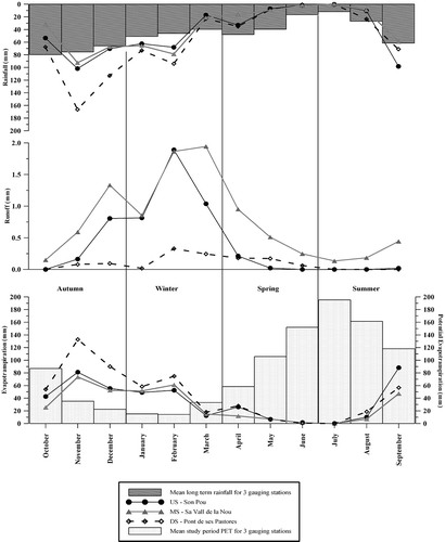
The mean annual P from the three gauging stations during the two study years was 550.5 mm. This value can be considered as average compared to the mean annual P for the 1970–2006 period (561.7 mm), with coefficients of variation of 13.0% spatially and 26.3% temporally conditioned by the high heterogeneity of the landscape and the irregularity of the Mediterranean climate. As the study period comprised two hydrological years, only seasonal differences were detected. Therefore, on an annual scale, average P was slightly higher in the first study year; being significantly higher at the DS site. However, at US and MS, P was lower during 2004/05 than 2005/06. On a seasonal scale, comparing the study period with the long-term data, autumn and winter accumulated more P than spring and summer, spring showed a significant decrease in P at the three stations, with total P lower than for summer, the season with the lowest P in the long term.
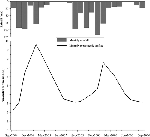
At the annual scale, there was a different R pattern between gauging stations. For example, DS accumulated 720 mm of P during 2004/05, whilst R was only 0.8 mm. In contrast, in 2005/06, P was lower (630.6 mm) and the R was doubled (1.6 mm). These significant annual contrasts were caused by different seasonal P distribution and surface water–groundwater interactions. Autumn was the rainiest season, although winter was the most hydrologically responsive period at the three gauging stations with 3.7 mm at US, 4.7 at MS and 0.6 mm at DS (). However, autumn and spring values were different depending on the response of each aquifer type and the human influences at gauging stations. Thus, autumn was the more responsive period at US and MS, because P is particularly intense during this season allowing a rapid response of impervious urban surfaces. However, at DS, spring was more responsive than autumn because at the end of winter aquifers were full allowing the predominance of influent dynamics which provided significant streamflow volumes, as depicted by the piezometric surface evolution during the study period (). During summer, R was only present at MS (0.8 mm), because the karstic springs of Na Borges Canyon and wastewaters from Manacor fed the stream continuously.
Fig. 3 Monthly piezometric surface measured by piezometer in a well located in the Na Borges Canyon flood plain, and monthly PET for the study period.
Very low values of runoff coefficient are analogous to those of temporary catchments having a similar hydroclimate (Tzoraki & Nikolaidis, Citation2007). Nevertheless, these values contrast with the high coefficients (≈25%) obtained in smaller tributaries that are mostly covered by deep impervious soils drained artificially by subsurface-tile drainage systems (Estrany et al., Citation2010) which cause an enhancement of streamflow. In contrast, the low runoff coefficients along the Na Borges River are explained by significant transmission losses produced mainly by lithological variations and high evaporation.
In terms of PET, summer had the highest value (538.7 mm), followed by spring, autumn and winter, with 352.1, 151.6 and 63.0 mm respectively (). Meanwhile, ET shows a different pattern conditioned by spatial and seasonal distribution of precipitation and by a high coefficient of percolation due to the pervious surfaces which cover 69% of the catchment. Nevertheless, the highest ET at all three gauging stations was in autumn, followed by winter, summer and spring, which registered the lowest P during the study period.
Using these main water balance elements (P, R and ET), linear regression relationships were established on a monthly time scale. However, none were statistically significant (r 2 < 0.3), as has been reported for other Mediterranean catchments (Ceballos & Schnabel, Citation1998; Latron et al., Citation2008). Despite the lack of linear relationships, the described water balance confirmed a general succession of four basic periods during the year generally determined by PET. A similar succession has already been highlighted by other authors in small mountainous catchments, where the climate undergoes changes due to altitude (Gallart et al., Citation2002; Latron et al., Citation2008). In this case, seasonal PET, different seasonal distribution of P (Macklin et al., Citation1995) and significant surface water–groundwater interactions (Sear et al., Citation1999) resulted in the following sequence:
| a. | A dry period In late spring and summer, evapotranspiration demand was very high and soils became dry and cracked (see evolution of the piezometric surface during this period in ). Under these conditions, at US, short, high-intensity late summer storms were only able to recharge the first soil horizons of the shallow aquifer of Pla de Son Pou, since the subsurface-tile drainage systems did not flow, and wastewater volumes were significantly lower than in winter because local inhabitants spent summer time at the coast (Kent et al., Citation2002). The conditions are the same at DS, although it must be emphasized that exploitation of the karstic aquifer over the last 50 years has captured a significant groundwater flow that, without pumping, would have discharged as baseflow to the stream (Garcia & Servera, Citation2003). However, late-summer storms at MS had a significant response due to karstic springs and wastewater contributions, which kept the hydrological pathways active so that the impervious urban surfaces generated a short catchment lag. | ||||
| b. | A transition period In early autumn, the effluent dynamics still predominate in almost the whole catchment. During this period P is only able to generate flash floods when rain falls intensely. In addition, evapotranspiration demand decreases, allowing P to recharge the aquifers. | ||||
| c. | A wet period corresponding to late autumn and winter Before the recharge process of shallow aquifers develop on the impervious sediments of Pla de Son Pou, runoff is also generated by saturation mechanisms when evapotranspiration losses are low compared to rainfall depths. Therefore, wet conditions ensured that P was more available for direct runoff. | ||||
| d. | A second transition period In spring there is diverse runoff behaviour, determined by the hydrogeology. Runoff at US was exhausted because high PET caused a rapid decrease in the shallow aquifer at Pla de Son Pou and interruption of the subsurface-tile drainage flow. However, at DS, due to the aquifers which had formed in Na Borges Canyon, influent dynamics predominated which discharged significant baseflow to the stream. | ||||
3.2 Runoff components and flow duration curves
In order to further evaluate the variability in streamflow response and the influence of catchment characteristics, R was separated into quickflow and baseflow for 37, 64 and 13 events at US, MS and DS, respectively. Subsequently, annual and seasonal FDCs (), and indices were established for total R and its components. In the data presented in , relative flow values present significant scatter, both seasonally and between gauging stations, caused by intra-annual hydroclimatic fluctuations and the catchment's hydrogeology:
Table 5 Relative seasonal and annual total flow and quickflow values for the years studied (2004–2006). Vi and 30/70 ratio for total flow on a seasonal and annual time scale for the study period (2004–2006)
Fig. 4 Flow–duration curves for total Q, baseflow and quickflow for the study period at each gauging station: (a) annual; (b) autumn; (c) winter; (d) spring, and (e) summer.
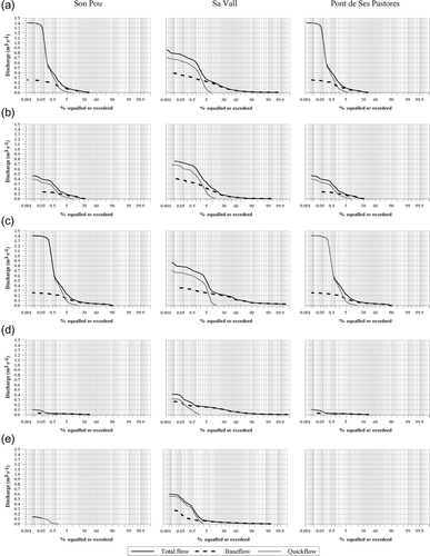
3.2.1 Total study period
The MS site presented the highest values based on contributions of karstic springs and the urban influence of Manacor. As a result, quickflow was present for 9.1% of the time, resulting in significantly high Vi and 30/70 ratio (0.410 and 1.591, respectively). Flow was present at the US site for 40.8% of the time with high Vi (0.407) and 30/70 ratio (1.369), because the impervious sediments of Pla de Son Pou and the urban influence of Sant Joan and Vilafranca allowed quickflow to reach 7.7%. Flow was present at the DS site for only 25% of the time as most headwater flow infiltrated along the Na Borges Canyon. In view of this, the presence of quickflow was relatively high (4.9%), based on the rapid hydrological response of the ephemeral tributaries of the Llevant ranges.
3.2.2 Annual
The MS site presented the highest values in 2004/05, as was shown previously. However, in 2005/06 the highest value was recorded at the US site because the rainfall accumulated during autumn was not enough to refill the shallow aquifer and sustain baseflow. As most of the rainfall was accumulated during winter, when evapotranspiration losses are low compared to rainfall depths favouring percolation, DS presented the lowest values with flow dynamics determined by baseflow from karstic aquifers.
3.2.3 Seasonal
In autumn there was a very similar flow trend at all gauging stations, with the highest seasonal Vi and 30/70 ratio values. Precipitation volumes and intensities during autumn were remarkable, a fact that resulted in a high peak discharge. However, as the deep impervious soils of Pla de Son Pou were not saturated and the water table of the aquifer was the lowest of the year (), effluent dynamics dominated so that Q was rapidly exhausted. These processes were more significant at DS during autumn because quickflow was the most important runoff component when flow was present. In winter, relative flow times increased significantly at US (90.1%) and to a lesser extent at DS (39.8%). Compared to autumn, the winter Vi was much lower, indicating that the most significant dynamic storage for the year had been at MS. Nevertheless, the 30/70 ratio values denote that winter flow variability was high – albeit short-term – as P was more available for direct R because antecedent conditions were wet, and therefore the quickflow presence gave the highest percentages on a seasonal scale. In spring, the percentage of time with flow decreased considerably at US (42.1%) and increased at DS (49.4%). These values show the different groundwater responses corresponding to the shallow aquifer at the headwaters and the karstic aquifer at the outlet. The lowest Vi values at US and DS denote that dynamic storage was predominant because in spring P was low during the study period, explaining also the low 30/70 ratio values. Summer was not considered at DS because flow was not present. At US, flow was present for only 1.2% of the period and was mainly quickflow. At MS, quickflow represented 4.6% of flow, because high-intensity late summer storms generated a rapid response from the impervious urban surfaces of Manacor.
In , QRR shows very low values due to high soil moisture deficits and high transmission losses. Based on its perennial regime, MS showed the highest QRR due to urban floods. In contrast, DS presents the lowest QRR as most headwater flow infiltrated along Na Borges Canyon. The US site presents a middle value resulting from the combination of wet and dry periods. On a seasonal time scale, winter had the highest QRR at all gauging stations. In this way, QRR at US reached values close to 1.0% during winter due to P events that occurred when antecedent conditions of the impervious soils of Pla de Son Pou were saturated, and the PET values were very low allowing P to be more available to runoff. Contrary to the average long-term P pattern, spring was the season with lowest P, producing low QRR values during the study period. Finally, autumn exhibited a higher QRR than spring, as there was more P.
Table 6 Total values for each R component in addition to QRR and BFI for each study year and seasonally
The BFI values illustrate the different baseflow dynamics at each gauging station. At MS, the value was 0.835 for the total study period. Indeed, most streamflow was baseflow, although urban flash floods slightly decrease the value. The US site gave a lower BFI (0.702) as, during dry periods, quickflow was predominant due to ephemeral behaviour. The DS site was the most ephemeral (0.562). On an annual scale, inter-seasonal P irregularity was noted, particularly at DS and US. Therefore, P in 2004/05 was concentrated mainly in autumn, whereas in 2005/06 it was mainly in winter. As a result, BFI in 2004/05 at DS was very low (0.275), because flow dynamics were determined by quickflow that originated in the Llevant ranges tributaries, where P shows essentially torrential behaviour during autumn. However, in 2005/06, this figure was 0.720 due to flow dynamics that were determined by baseflow from karstic aquifers and headwaters, because, during winter, mid-latitude westerlies and associated frontal systems bring general rainfall that favours percolation processes. In contrast, BFI at US in 2004/05 was 0.807, with baseflow dynamics dominating, as the shallow aquifer and subsurface-tile drainage systems of Pla de Son Pou were refilled during the autumn P events, the flat topography favouring infiltration even under intense precipitation. In 2005/06, BFI at US was 0.597, as the shallow aquifer was not refilled and subsurface-tile drainage systems did not work properly until the middle of winter, allowing quickflow dynamics to predominate.
Finally, annual and seasonal linear regression relationships were established on a monthly basis through P and quickflow (). The significant correlation reinforces the explained streamflow variability evaluated by means of QRR and BFI at annual and seasonal time scales.
Table 7 Seasonal linear correlation coefficients between P and quickflow for study period (2004–2006) on a monthly scale
3.3 Baseflow dynamics: recession curves
The surface water–groundwater interaction was the determining factor in the recession curve behaviour of the Na Borges River according to aquifer diversity. Therefore, recession characteristics were analysed in order to assess the influence of these surface water–groundwater interactions on streamflow.
From instantaneous Q measured daily at 06:00 UTC, when P was negligible, 14 recession periods were selected at US, ranging from 2 to 15 days with Q between 0.739 and 0.004 m3 s-1; 11 recession periods were selected at MS ranging from 2 to 16 days with Q between 0.749 and 0.041 m3 s-1; and, 10 recession periods were selected at DS, ranging from 2 to 12 days with Q between 0.586 and 0.001 m3 s-1.Using the strip matching method, master recession curves (MRC) were derived by means of a set of common lines () emphasizing the particular control exerted by groundwater dynamics at each gauging station.
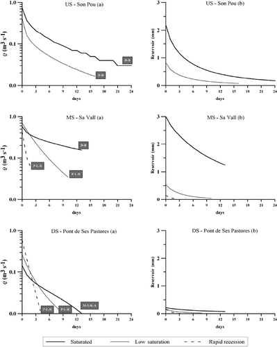
Fig. 5 (a) Master recession curves at each gauging station, and (b) evolution of reservoir volume available for R at each gauging station. The storage–outflow models are: D-B (Dupui-Boussinesq); P-L-R (power-law reservoir); and M-E-K-A (Mangin's equation for karstic aquifers).
As described in Section 2.3.3, the saturation states at each gauging station related to soil moisture antecedent conditions and PET values were the result of diverse causes, as described below ():
Table 8 Recession curve equations, Q, maximum available reservoir (RA) and recession coefficient (X) for t = 0, 7 and 13 days
3.3.1 Upstream site
| a. | Saturated The Dupuit-Boussinesq model was fitted to the unconfined and shallow aquifer dynamics. The initial recession coefficient (0.205) shows a steep segment in the upper part of the recession curve as a result of the fast response to P from impervious urban surfaces of Vilafranca and Sant Joan and from agricultural fields developed on impervious Lower-Middle Miocene sediments. Although this steep segment also reflects a rapid exhaustion of quickflow, the other parts of the curve have lower recession coefficients (0.098 and 0.096) because the great water volumes stored in soils developed on the impervious Lower-Middle Miocene sediments are released slowly by means of subsurface-tile drainage systems. | ||||
| b. | Low saturation The Dupuit-Boussinesq model was also fitted. It shows a higher recession coefficient because the shallow aquifer and subsurface-tile drainage systems still maintain baseflow. In addition, the other parts of the curve sustain high recession coefficients for the same reason. | ||||
| c. | Rapid recession This process did not take place during the study period. | ||||
3.3.2 Middle site
| a. | Saturated The Dupuit-Boussinesq model was fitted due to the influence of headwater flow, specifically when both the shallow aquifer developed in the impervious Lower-Middle Miocene sediments and the karstic aquifer are saturated; headwater flood events transfer the same saturated-state characteristics as for the upstream site to the recession curves of the MS site. Thereafter, from the upper part of the recession curve, coefficients were very low, the lowest of all being observed in the Na Borges River. | ||||
| b. | Low saturation A power-law reservoir model was fitted because it is the best-fit storage–outflow model for springs and unconfined aquifers. The Na Borges Canyon presents an influent Q fed only by karstic springs and wastewaters. However, the low saturation of the shallow aquifer developed in the impervious Lower-Middle Miocene sediments confers a recession curve adjusted to the power-law model. Consequently, recession coefficients were substantially higher than for saturated state (0.426 for X 0 and 0.254 for X 7) along the entire curve. | ||||
| c. | Rapid recession The power-law reservoir model was also fitted but with a lower level of saturation. It takes place during low and spasmodic events, which come from impervious urban surfaces of Manacor, and duration was only 2 days. As a result, recession coefficients are very high (0.872 for X 0). | ||||
3.3.3 Downstream site
| a. | Saturated Mangin's equation for karstic aquifers was fitted. When the piezometric surface of the different aquifers of Na Borges Canyon was high (), flood events from headwater parts reached the gauging station, and baseflow was sustained. Consequently, the initial recession coefficient (0.177 for X 0) shows a steep segment in the upper part of the recession curve, reflecting the contribution of quickflow from Llevant Ranges tributaries. However, the other parts exhibit lower coefficients as a result of baseflow contributions (0.070 and 0.035 for X 7 and X 13, respectively). | ||||
| b. | Low saturation A power-law reservoir model was fitted when different aquifers of the Na Borges Canyon have a minimum of saturation conditions to activate hydrological pathways, allowing the first flood headwater events to reach the gauging station. However, it was not enough to sustain baseflow for long. Thus, recession coefficients are high (0.440 for X 0 and 0.169 for X 7). | ||||
| c. | Rapid recession This occurs when the aquifers of Na Borges Canyon are not connected to the channel. Under these conditions, only flash-flood events generated in the steep and ephemeral tributaries of the Llevant ranges reach the gauging station. The power-law reservoir model was also fitted. | ||||
3.4 Quickflow dynamics: event-scale rainfall–runoff relationships
Quickflow was present for less than 10% of the study period at all gauging stations, but represented the catchment's response to P. Independent variables (antecedent conditions and P) can be classified according to theories of R generation mechanisms: (a) the Horton theory relating to P intensity variables, and (b) the Dunne theory relating to antecedent conditions and total P. According to Horton (Citation1933), surface R can occur when P intensity exceeds the infiltration capacity of the soil. Furthermore, P duration must be greater than ponding time. According to Dunne's statement (Dunne & Black, Citation1970), if P intensity is lower than infiltration capacity, surface R is produced by P over the area where water table is at the surface. At the event scale, quickflow is likely to occur if the initial water table is shallow.
Against this hydrological background, shows the multiple regression equations that were derived; in each case, the multiple correlation coefficient was about 0.8. These equations summarize the hydrological processes involved in runoff generation at the US and MS sites:
Table 9 Rainfall–runoff relationship equations derived from the application of the stepwise multiple regression technique and subsequent β coefficients
The first equation explains Q max, which integrates the two runoff components. The different surface water–groundwater interactions at US and MS did not provide a different runoff response as PET was the most important variable in the water balance. Consequently, the highest values of Q max were reached with wet antecedent conditions, a fact corroborated by the two related variables in the equation. However, the total value of the β coefficients for antecedent precipitation (X 1–X 4) (β = 0.869 at US and 0.639 at MS) shows a difference between the two stations. Therefore, when soil was at field capacity, Q max was more significant at US due to the soil type, whereas, at MS, the contribution of wastewaters and karstic springs reduced the relative importance of antecedent conditions. Likewise, when total event precipitation (X 5) was greater, Q max was higher. Their β coefficients (0.630 at US and 0.803 at MS) are the highest of all variables, indicating that they were the most influential. Finally, 5′ maximum P intensity (X 6) shows a negative tendency during the study period as the highest P intensities occurred during late summer and autumn when soil was not saturated and baseflow was lower, so Q max was lower although precipitation intensity was higher.
The second equation only evaluates one of the R components: Q runoff. In this case, antecedent conditions were not as important as in the first equation. Therefore, only one antecedent precipitation variable (X 3 at US and X 2 at MS) was present at each gauging station. The β coefficients (0.401 at US and 0.215 at MS) are lower than the antecedent condition variables from the first equation. Compared to US, the MS values again reflect a lower dependence on antecedent conditions due to impervious urban surfaces. Variables related to total precipitation (X 5 and X 7) were the most important due to their direct relationship with quickflow. In the case of US, the variable related to P is storm event duration. The β coefficients were 0.534 for US and 0.461 for MS. The different β coefficient values between stations indicate a high dependence on P at US, related to heavy P produced by winter frontal systems when antecedent conditions were wet. In contrast, the β coefficient at MS was lower because Q runoff depends on both antecedent conditions and urban contributions. The 5′ P intensity (X 6) modifies Q runoff negatively again at MS only. However, at US, P intensity variables were not present because during late summer, when P intensities were significant, no flood event was recorded causing the correlation coefficient to be the lowest of all equations. Finally, the time interval between median P event and Q max (X 8) determines the MS equation. If the interval is longer, Q runoff will be higher due to flow contribution from headwaters.
4. SUMMARY AND CONCLUSIONS
We have analysed streamflow variability in the Na Borges River for a period of two averaged years. This catchment is particularly interesting for its surface water–groundwater interaction in a Mediterranean environment, historically transformed by agricultural soil and water conservation practices and recently by urbanization. The basic conclusions are:
| 1. | The water balance provides a general overview of the hydrological variables on a seasonal scale. The mean annual R coefficients were very low because of transmission losses and evaporation dynamics. The lack of a linear relationship between P and R on the annual and seasonal time scales can be related to the limited range of evapotranspiration scenarios. Consequently, it was only possible to observe a succession of four different hydrological periods throughout the year conditioned by evapotranspiration and surface water–groundwater interaction, the main variables determining the streamflow variation. | ||||
| 2. | The FDCs show significant scatter seasonally and between gauging stations as a result of the intra-annual hydroclimatic fluctuations and the hydrogeology of the catchment. While flow was present at the middle site (MS) 100% of the time, it was just 40.8% at the upstream site (US) and less than 25% at the downstream site (DS). Winter was the season when more flow was present at US (90.1%), whereas for DS it was spring (49.4%). Quickflow presence reached 9.1 and 7.7% at MS and US, respectively, due mainly to urban influence. However, at DS it was only 4.9%. | ||||
| 3. | Quickflow response ratios (QRR) were very low on an annual scale, indicating high soil moisture deficits and high transmission losses due to PET, and surface water–groundwater interactions. On the seasonal scale, QRR clearly explains the succession of four hydrological periods associated with water-storage dynamics, in the same way as the baseflow index, BFI. At MS, karstic contributions provided a BFI value where baseflow was the main R component (0.835). At US, the BFI was lower (0.702), as the ephemeral regime is predominant during dry periods. Finally, the BFI at DS (0.562) shows that ephemeral behaviour determined R, as most headwater flow was infiltrated and a significant degree of flow was generated by flash flooding from the Llevant ranges tributaries. | ||||
| 4. | Linear relationships between P and quickflow were established on a monthly basis. These were significant on an annual level at MS and during spring and autumn at US and DS respectively, corroborating the dynamics explained by QRR and BFI. | ||||
| 5. | Due to the importance of groundwater–surface water interactions and their effect on baseflow dynamics, it was necessary to study recession periods. Master recession curves were established according to three aquifer saturation states (saturated, low saturated, rapid recession). Remarkable differences were observed between the three states at each gauging station and between gauging stations, in terms of hydrogeological and hydrometeorological variations, as well as human influences such as the contribution of wastewater and subsurface-tile drainage systems. | ||||
| 6. | At US and MS, stepwise multiple regressions were established to analyse rainfall–runoff relationships. Maximum peak Q and Q runoff were dependent variables from antecedent conditions and variables relating to P were independent. Both dependent variables were mainly influenced by the Dunne mechanism but were more influential at US due to the shallow aquifer. At MS, however, karstic and urban contributions reduced the control exerted by antecedent soil conditions. Furthermore, during the study period, Hortonian variables showed a negative tendency in R behaviour, as when P was torrential during dry seasons; baseflow was not present at US or was insignificant at MS with high transmission losses in an effluent period. | ||||
These results provide a valuable insight into the hydrology of a Mediterranean temporary river, in which the streamflow variability depends on three main variables:
| a. | PET and surface water–groundwater interactions were the most influential variables on streamflow variability on the annual and seasonal time scales generating a succession of four different hydrological periods. The very low R coefficients are related to transmission losses caused by groundwater dynamics and PET. | ||||
| b. | Additionally, groundwater also determined the quickflow and baseflow response, which was significantly different according to the aquifer type at each gauging station. However, during the study period, P intensity variables indicate a negative tendency in R behaviour as the Hortonian mechanism was limited to dry seasons when baseflow was insignificant, causing Q values to be lower. | ||||
| c. | Finally, urban expansion impacted on hydrological processes with a continuous flow by means of wastewater, while agricultural subsurface-tile drainage systems enhance streamflow seasonally at headwaters. Furthermore, at MS, especially during dry seasons, quickflow was significant since wastewaters maintained active hydrological pathways allowing a lag response of impervious urban surfaces. | ||||
Acknowledgements
This work was funded by the Spanish Ministry of Education and Science (REN2001-0281) and by agreement between the Spanish Ministry of the Environment (LUCDEME project) and the University of the Balearic Islands. The authors are grateful to Maria Galmès (alias des Cabanells) and Carmelo López, the petrol-station workers who collaborated in the monitoring at DS gauging station. Thanks must also be expressed to Joan Miquel Carmona for his technical assistance during the construction process and field work, as well as to Jordi Giménez and Concepción González from the Balearic Island Autonomous Government for their data support. Reviews by Damià Vericat and an anonymous reviewer greatly improved the final version of the manuscript. The authors are indebted to them for the constructive and helpful contributions.
Notes
Citation Estrany, J., Garcia, C. & Alberich, R. (Citation2010) Streamflow dynamics in a Mediterranean temporary river. Hydrol. Sci. J. 55(5), 717–736.
1Garrigue is a type of low, soft-leaved scrubland found on limestone soils around the Mediterranean Basin where annual summer drought conditions predominate.
Related Research Data
REFERENCES
- Barnes , B. S. 1940 . Discussion of analysis of runoff characteristics . Trans. Am. Soc. Civ. Engrs , 105 : 106
- Boussinesq , J. 1904 . Recherches theoretique sur l'ecoulement des nappes d'eau infiltrees dans le sol et sur le debit des sources . J. Math. Pure Appl. , 10 ( 5 ) : 5 – 78 .
- Ceballos , A. and Schnabel , S. 1998 . Hydrological behaviour of a small catchment in the dehesa landuse system (Extremadura, SW Spain) . J. Hydrol. , 210 : 146 – 160 . doi:10.1016/S0022-1694(98)00180-2
- Diaz Palmer , A. , Garcia , C. , Servera , J. and Úbeda , X. 2006 . Spatial variability of total nitrogen, total carbon and organic carbon content in the top-soil of the Na Borges basin, Mallorca, Spain . Z. Geomorphol. , 143 : 83 – 94 .
- Dunne , T. and Black , R. D. 1970 . Partial area contributions to storm runoff in a small New England watershed . Water Resour. Res. , 6 ( 5 ) : 1296 – 1311 .
- Estrany , J. , Garcia , C. and Batalla , R. J. 2009 . Groundwater control on the suspended sediment load in the Na Borges River, Mallorca (Spain) . Geomorphology , 106 ( 3–4 ) : 292 – 303 . doi:10.1016/j.geomorph.2008.11.008
- Estrany , J. , Garcia , C. and Batalla , R. J. 2010 . Hydrological response of a small Mediterranean agricultural catchment . J. Hydrol. , 380 ( 1-2 ) : 180 – 190 . doi:10.1016/j.jhydrol.2009.10.035
- Gallart , F. , Amaxidis , Y. , Botti , P. , Canè , G. , Castillo , V. , Chapman , P. , Froebrich , J. , García-Pintado , J. , Latron , J. , Llorens , P. , Lo Porto , A. , Morais , M. , Neves , R. , Ninov , P. , Perrin , J. L. , Ribarova , I. , Skoulikidis , N. and Tournoud , M. G. 2008 . Investigating hydrological regimes and processes in a set of catchments with temporary waters in Mediterranean Europe . Hydrol. Sci. J. , 53 ( 3 ) : 618 – 628 .
- Gallart , F. , Llorens , P. , Latron , J. and Regüés , D. 2002 . Hydrological processes and their seasonal controls in a small Mediterranean mountain catchment in the Pyrenees . Hydrol. Earth System Sci. , 6 : 527 – 537 .
- Garcia , C. and Servera , J. 2003 . Impacts of tourism development on water demand and beach degradation on the Island of Mallorca (Spain) . Geogr. Annal. A , 85 ( 3-4 ) : 287 – 300 .
- Govern de les Illes Balears . Pla Hidrològic de les Illes Balears . Conselleria de Medi Ambient, Ordenació del Territori i Litoral, Direcció General de Règim Hidràulic, Junta d'Aigües de Balears . Palma, Spain.
- Gregory , K. J. and Walling , D. E. 1973 . Drainage Basin Form and Process. A Geomorphological Approach , London : Edward Arnold .
- Grove , A. T. 1996 . “ The historical context: before 1850. Chapter 2. In ” . In Mediterranean Desertification and Land Use , Edited by: Brandt , C. J. and Thornes , J. 13 – 28 . Chichester : Wiley .
- Hall , F. R. 1968 . Base flow recession – a review . Water Resour. Res. , 4 ( 5 ) : 973 – 983 .
- Hewlett , J. D. 1982 . Principles of Forest Hydrology , Athens, GA : University of Georgia Press .
- Horton , R. E. 1933 . The role of infiltration in the hydrologic cycle . EOS, Trans. Am. Geophys. Union , 14 : 446 – 460 .
- Keller , E. A. and Kondolf , G. M. 1990 . Groundwater and fluvial processes: selected observations . Geol. Soc. Am. Spec. Paper , 252 : 319 – 340 .
- Kent , M. , Newnham , R. and Essex , S. 2002 . Tourism and sustainable water supply in Mallorca: a geographical analysis . Applied Geography , 22 ( 4 ) : 351 – 374 . doi:10.1016/S0143-6228(02)00050-4
- Lane , E. W. and Lei , K. 1950 . Streamflow variability . Trans. Am. Soc. Civ. Engrs , 20 : 1084 – 1134 .
- Latron , J. 2003 . Estudio del funcionamiento hidrológico de una cuenca mediterránea de montaña (Vallcebre, Pirineos Catalanes) , Barcelona, , Spain : PhD Thesis, Universitat de Barcelona .
- Latron , J. , Soler , M. , Llorens , P. and Gallart , F. 2008 . Spatial and temporal variability of the hydrological response in a small Mediterranean research catchment (Vallcebre, Eastern Pyrenees) . Hydrol. Processes , 22 ( 6 ) : 775 – 787 . doi:10.1002/hyp.6648
- Macklin , M. G. , Lewin , J. and Woodward , J. C. 1995 . “ Quaternary fluvial systems in the Mediterranean basin ” . In Mediterranean Quaternary River Environments , Edited by: Lewin , J. , Macklin , M. G. and Woodward , J. C. 1 – 25 . Rotterdam : A.A. Balkema .
- Mosley , M. P. and McKerchar , A. 1993 . “ Streamflow ” . In Handbook of Hydrology , Edited by: Maidment) , D. R. 8.1 – 8.39 . New York : McGraw-Hill . Ined. by
- Nathan , R. J. and McMahon , T. A. 1990 . Evaluation of automated techniques for base flow and recession analysis . Water Resour. Res. , 26 : 1465 – 1473 .
- Padilla , A. , Pulido-Bosch , A. and Mangin , A. 1994 . Relative importance of baseflow and quickflow from hydrographs of karst springs . Ground Water , 32 ( 2 ) : 267 – 277 . doi:10.1111/j.1745-6584.1994.tb00641.x
- Peters , N. E. 1994 . “ Hydrologic processes ” . In Biogeochemistry of Small Watersheds: A Tool for Environmental Research , Edited by: Moldan , B. and Cerny , J. 189 – 206 . Chichester : Wiley . InSCOPE Publ. 51
- Pons-Esteva , A. 2000 . Evolució dels usos del sòl a les illes Balears: 1956–2000 . Territoris , 4 : 129 – 145 .
- Romero , R. and Ramis , C. 2002 . Torrential daily rainfalls patterns in Mediterranean Spain and associated meteorological settings . Tethys , 2
- Sear , D. A. , Armitage , P. D. and Dawson , F. H. 1999 . Groundwater dominated rivers . Hydrol. Processes , 13 : 255 – 276 .
- Smakhtin , V. U. 2001 . Low flow hydrology: a review . J. Hydrol. , 240 : 147 – 186 . doi:10.1016/S0022-1694(00)00340-1
- Syvitski , J. P. M. 2003 . The supply of flux of sediment along hydrological pathways: anthropogenic influences at the global scale . Global Planet. Change , 39 ( 1-2 ) : 1 – 11 .
- Tallaksen , L. M. 1995 . A review of baseflow recession analysis . J. Hydrol. , 165 : 349 – 370 . doi:10.1016/0022-1694(94)02540-R
- Thornthwaite , C. W. 1948 . An approach toward a rational classification of climate . Geogr. Rev. , 38 : 55 – 94 .
- Toebes , C. and Strang , D. D. 1964 . On recession curves 1: recession equations . J. Hydrol. , 3 : 2 – 15 .
- Tzoraki , O. and Nikolaidis , N. P. 2007 . A generalized framework for modeling the hydrologic and biogeochemical response of a Mediterranean temporary river basin . J. Hydrol. , 346 ( 3-4 ) : 112 – 121 . doi:10.1016/j.jhydrol.2007.08.025
- Wainwright , J. and Thornes , J. B. 2004 . Environmental Issues in the Mediterranean: Processes and Perspectives from the Past and Present , London : Routledge .
- White , W. B. 2002 . Karst hydrology: recent developments and open questions . Engng Geol. , 65 ( 2-3 ) : 85 – 105 . doi:10.1016/S0013-7952(01)00116-8
- Woodruff , J. F. and Hewlett , J. D. 1970 . Predicting and mapping the average hydrologic response for the Eastern United States . Water Resour. Res. , 6 ( 5 ) : 1312 – 1326 .