Abstract
Accurate estimation of groundwater recharge is essential for the proper management of aquifers. A study of water isotope (δ2H, δ18O) depth profiles was carried out to estimate groundwater recharge in the Densu River basin in Ghana, at three chosen observation sites that differ in their altitude, geology, climate and vegetation. Water isotopes and water contents were analysed with depth to determine water flow in the unsaturated zone. The measured data showed isotope enrichment in the pore water near the soil surface due to evaporation. Seasonal variations in the isotope signal of the pore water were also observed to a depth of 2.75 m. Below that depth, the seasonal variation of the isotope signal was attenuated due to diffusion/dispersion and low water flow velocities. Groundwater recharge rates were determined by numerical modelling of the unsaturated water flow and water isotope transport. Different groundwater recharge rates were computed at the three observation sites and were found to vary between 94 and 182 mm/year (± max. 7%). Further, the approximate peak-shift method was applied to give information about groundwater recharge rates. Although this simple method neglects variations in flow conditions and only considers advective transport, it yielded mean groundwater recharge rates of 110–250 mm/year (± max. 30%), which were in the same order of magnitude as computed numerical modelling values. Integrating these site-specific groundwater recharge rates to the whole catchment indicates that more water is potentially renewed than consumed nowadays. With increases in population and irrigation, more clean water is required, and knowledge about groundwater recharge rates – essential for improving the groundwater management in the Densu River basin – can be easily obtained by measuring water isotope depth profiles and applying a simple peak-shift approach.
Citation Adomako, D., Maloszewski, P., Stumpp, C., Osae, S. & Akiti, T. T. (2010) Estimating groundwater recharge from water isotope (δ2H, δ18O) depth profiles in the Densu River basin, Ghana. Hydrol. Sci. J. 55(8), 1405–1416.
Résumé
L'estimation précise de la recharge des eaux souterraines est essentielle pour la bonne gestion des aquifères. Une étude de profils de profondeur des isotopes de l'eau (δ2H, δ18O) a été réalisée pour estimer la recharge des eaux souterraines dans le bassin de la rivière Densu au Ghana, pour trois sites d'observation choisis qui diffèrent par leurs altitude, géologie, climat et végétation. Les isotopes de l'eau et les teneurs en eau ont été analysés selon la profondeur pour déterminer le flux d'eau dans la zone non saturée. Les données ont montré l'enrichissement isotopique de l'eau interstitielle à proximité de la surface du sol en raison de l'évaporation. Les variations saisonnières dans le signal isotopique de l'eau interstitielle ont également été observées à une profondeur de 2.75 m. Sous de cette profondeur, la variation saisonnière du signal isotopique a été atténuée en raison de la diffusion/dispersion et des faibles vitesses d'écoulement de l'eau. Les taux de recharge des eaux souterraines ont été déterminés par modélisation numérique de l'écoulement de l'eau non saturé et du transport des isotopes de l'eau. Différents taux de recharge des eaux souterraines ont été calculés sur les trois sites d'observation et variaient entre 94 et 182 mm/an (± max. 7%). En outre, la méthode du décalage des pics a été appliqué pour améliorer la connaissance des taux de recharge. Bien que cette méthode simple néglige les variations des conditions d'écoulement et ne considère que le transport advectif, elle a donné des taux moyens de recharge des eaux souterraines de 110–250 mm/an (± max. 30%), qui sont du même ordre de grandeur que les valeurs numériques calculées par modélisation. L'intégration de ces taux stationnels de recharge des eaux souterraines à l'ensemble du bassin versant indique que l'eau est potentiellement plus renouvelée que consommés de nos jours. Avec l'augmentation de la population et de l'irrigation, l'eau de qualité est nécessaire en plus grande quantité, et connaissance des taux de recharge des eaux souterraines – essentielle pour améliorer la gestion des eaux souterraines dans le bassin de la Rivière Densu – peut être facilement obtenu en mesurant les profils en profondeur des isotopes de l'eau et en appliquant une méthode simple de décalage des pics.
INTRODUCTION
Groundwater resource development in the Densu River basin, Ghana, contributes substantially to the economic status and livelihoods of the population. About 80% of the total population in the Densu River basin depends on groundwater (WRI, Citation1994). However, sometimes the use of groundwater is insufficient because of poor productivity of wells, drying of wells after prolonged droughts, or due to poor water quality. Additionally, the groundwater resources are under serious threat due to increases in the population density in the basin. Mechanized agricultural practices, as well as domestic and industrial usage, require large amounts of irrigation and drinking water. Therefore, increasing attention is paid to both the quantity and mechanisms of groundwater recharge and to the transport of potential contaminants through the unsaturated zone (McConville et al., Citation2001). Further, accurate estimation of groundwater recharge and an understanding of recharge mechanisms are necessary to avoid overexploitation, and to assess the risk of groundwater contamination, particularly that from diffuse use of pesticides and nitrates in agriculture (Shukla et al., Citation1998). Therefore, it is important to understand flow processes and groundwater recharge in terms of groundwater resource evaluation and the impact of contaminants from the soil system.
Water isotopes oxygen-18 (18O) and deuterium (2H), being conservative tracers, are ideal for investigating subsurface flow processes. They reveal information about soil water fluxes (e.g. evaporation, transpiration and downward infiltration) that are difficult to determine by other techniques (see e.g. Allison & Barnes, Citation1983, Citation1985; Gazis & Feng, Citation2004; Stumpp et al., Citation2007). These isotopes are naturally abundant in precipitation. Due to fractionation effects, a seasonally variable distribution of water isotopes occurs in the precipitation of temperate and continental regions. This seasonal distribution is attenuated by transport processes in the subsurface and can still be reflected in shallow groundwater systems (Clark & Fritz, Citation1997; Abbot et al., Citation2000). Therefore, knowledge of the water isotope content of precipitation, soil water and groundwater can give information about water flow, and groundwater recharge rate estimations can be inferred.
Oxygen-18 and deuterium have been used extensively in catchment studies to determine groundwater recharge, transit times and water flow paths (Abbott et al., Citation2000; McGuire et al., Citation2002; O'Driscoll et al., Citation2005; Reedy et al., Citation2006). In arid and semi-arid regions, evaporation rates have been determined using deuterium and oxygen-18 enrichment in soil water near the subsurface (e.g. Allison & Barnes, Citation1983, Citation1985; Fontes et al., Citation1986; Barnes & Allison, Citation1988; Darling & Bath, Citation1988; Barnes & Walker, Citation1989; Hsieh et al., Citation1998). In such regions, isotope enrichment due to evaporation through the soil surface is more prominent.
Several others studies of 18O or 2H in soil water estimated flow processes and groundwater recharge rates in the unsaturated zone of temperate climates (Geake & Foster, Citation1989; McConville et al., Citation2001; Maloszewski et al., Citation2006; Stumpp et al., Citation2009a,Citationb), where the effect of evaporation is mostly small or even negligible. In humid regions, water flow velocities and dispersion dominate the change in water isotope contents on their way through the subsurface (Barnes & Turner, Citation1998).
The objective of this study was to estimate groundwater recharge rates using hydro-meteorological data and vertical depth profiles of water isotopes in the unsaturated zone in the Densu River basin. It was tested whether groundwater recharge rates can be calculated from a limited amount of data using a simple piston flow model approach. Three sites were chosen that are representative of the basin in terms of geology, altitude and vegetation. Groundwater recharge rates were determined at these sites and compared to computed values from transient variable flow and transport modelling and water balance approaches.
STUDY AREA
Location
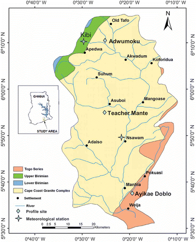
The Densu River basin (5°30′–6°20′N; 0°10′–0°35′W) is located in the southeastern part of Ghana (). The catchment has an area of 2564 km2, spans 10 district assemblies, and lies within three regions of Ghana: the Eastern, Greater-Accra and Central regions. There are about 200 settlements in the basin with a population density ranging from 150 to 200 per square kilometre, which is above the national average of 77 persons per km2 (Ghana Statistical Service, 2000). The main occupation is agriculture, which engages about 39% of the economically active population (Nii Consult, Citation2001). The basin is characterized by undulating topography with hills of craggy summits, giving a striking appearance to the landscape. The Densu River takes its source from the Atewa Range near Kibi in the East Akim Metropolitan Assembly, in the Eastern Region of Ghana. It flows for 116 km from its source (760 m a.s.l.) to the Gulf of Guinea through the tidal lagoon at Botianor, west of Accra. The main tributaries include the rivers Mame, Kuia, Adeiso, Dobro and Nsaki. The Densu River basin borders on the Odaw basin in the east, the Volta basin in the north, the Birim basin in the north-west, and the Ayensu and Okrudu basins in the west.
Fig. 1 Map of the study area showing the geology and the location of the three investigated sites and the two meteorological stations.
Climate
The study area lies between two distinct climatic zones: the dry equatorial climate of the southeastern coastal plains and the wet semi-equatorial climate further north from the coast. Both climatic zones are characterized by two rainfall seasons with different intensities (Dickson & Benneh, Citation1998). The major rainy season extends from April/May to July, and attains a peak in June when the maritime instability causes a surge of the moist southwesterly air stream resulting in the intensification of the monsoon rain. The minor season occurs between September and November when several disturbance lines give rise to local thunderstorm activity, especially in the upper and middle belts which are covered with moist semi-deciduous forest. The total annual rainfall ranges from 1700 mm in the wet interior to 800 mm in the dry equatorial zone near the coast.
The climate of the study area is characterized by prevailing high temperatures throughout the year. The mean annual temperature is 27°C, with March/April being the hottest month (32°C), and August the coldest (23°C). The maximum and minimum relative humidity values vary from 89 to 93% and 41 to 72%, respectively.
General geology
The Densu River basin is mainly underlain by the Proterozoic basin-type granitoid batholiths associated with gneiss: the so-called Cape Coast Granite Complex. This geological formation covers a large part of the basin (90%), as shown in . It comprises heterogeneous groups of rocks occupying most of the north-western corner. The bulk of the Cape Coast Granite is composed of quartz, muscovite, orthoclase and albite. The granite changes from fine to medium grained; foliated biotite quartz diorite gneiss to hornblende–quartz diorite gneiss. These gneissic rocks are intruded by both acidic and basic igneous rocks, which include white and pink pegmatite, aplite, granodiorite and peridotite.
The Birimian formation, which occurs at the watershed of the river in the north-west, covers approximately 4% of the basin. Traditionally, Junner (Citation1935, Citation1940) subdivided the Birimian Supergroup into two parts: the Lower and Upper Birimian. The Lower Birimian consists of dacitic/rhyodacitic volcaniclastics, greywackes, phyllites, argillites and chemical sediments (Leube & Hirdes, Citation1986). The Upper Birimian, is mainly made up of tholeiitic basalts with intercalated volcaniclastics, pyroclastic lava and hypabyssal basic intrusions. Most of the rocks have metamorphosed into calcareous chlorite schists and amphibolites (greenstones). Rocks belonging to the Birimian formation are sandstones, tuffs, grit, quartzites and some breccia.
The Togo Series, which covers 6% of the catchment, occur in the southeastern part of the area and forms the estuary of the Densu River. The rocks of the Togo Series are highly folded and jointed, and form the chain of hills known as the Akwapim-Togo Ranges, which extend from the coast near Accra to the Togo border. The Togo Series consists of sandstone, quartzite and quartz schist, shale, phyllite and some talc mica schist.
MATERIAL AND METHODS
Sampling
Three sampling sites were selected that are representative for the basin (Adwumoku, Teacher Mante and Ayikae Doblo; ). These sites differ in altitude, geology and vegetation. In June/July 2008, a mechanical auger from the Ghana Geological Survey (GGS) was used for drilling soil profiles. The depths of the profiles at the sites Adwumoku, Teacher Mante and Ayikae Doblo were 5.0, 5.5 and 6.0 m, respectively. Bulk samples were taken at a regular interval of 25 cm.
About 500–1000 g of the bulk soil were collected in polyethylene bags, tightly sealed and later packed in an ice chest to prevent moisture loss due to evaporation. The texture was analysed with a resolution of one metre in all soil profiles using the hydrometer method according to the US Department of Agriculture soil classification. Gravimetric water content and bulk density were determined (Blake & Hartge, Citation1986) by drying 150 g of each soil sample in an oven at a temperature of 105°C for 24 h. From these data, volumetric water contents and the total porosity were calculated.
Rainwater samples were collected from the study area on an event basis (2006–2008) at the two meteorological stations Nsawam and Kibi (). From March 2007 to September 2008, the precipitation at the Kibi station (320 m a.s.l.) was collected and used for isotope analysis. The meteorological data were taken to calculate the grass reference evapotranspiration using the Penman-Monteith method according to the FAO-56 guideline (Allen et al., Citation1998). These values were adjusted for the actual vegetation using crop coefficients from the guidelines (Allen et al., Citation1998).
Method of extraction and isotope analysis
The soil water was extracted from the bulk soil samples for analysis of water isotopes. As described by Araguás-Araguás et al. (Citation1995), a vacuum extraction line consisting of three parallel units with cryogenic collection of the extracted soil water was used. At the beginning of each extraction run the system was degassed, and a static vacuum was applied. Each soil sample (approx. 250 g) was placed in a 1000-mL Pyrex round-bottomed flask and connected to a vacuum line. The samples were heated in a 70°C bath for 6 h. The temperature was maintained below 100°C to reduce the risk of removing any loosely bound water (i.e. immobile water) in the clay lattice, which otherwise will introduce errors in the isotope composition of the extracted water (Araguás-Araguás et al., Citation1995). The water vapour was collected by a connected glass tube using liquid nitrogen traps. Subsequently, the nitrogen traps were taken off and the frozen water in the glass tubes turned into water. The extracted water was then poured into 30-mL glass bottles and tightly sealed to prevent evaporation. Comparing the weight of the obtained water to the loss of weight of the soil samples confirmed the completion of the extraction and was taken as a reference to exclude evaporation loss during the procedure.
Water isotopes 18O and 2H of the extracted soil water were determined using Thermo Finnegan Delta isotope mass spectrometry. The water samples for oxygen isotope analysis were prepared by conventional H2O–CO2 equilibration (Epstein & Mayeda, Citation1953) where 5 mL of each sample was equilibrated with CO2 gas at 25 ± 0.1°C for 24 h. The CO2 gas was then extracted and cryogenically purified in a vacuum line. For deuterium analysis, Cr at 850°C was used to produce hydrogen gas (Coleman et al., Citation1982). Both 18O and 2H contents were determined relative to internal standards that were calibrated using Vienna-Standard Mean Ocean Water (V-SMOW). The data were normalized and reported in the delta notation (Coplen, Citation1988):
Groundwater recharge estimation
Two different approaches were applied to determine the groundwater recharge rates based on the measured water isotope profiles. In one approach, exact transient flow and transport modelling was used to calculate groundwater recharge rate on a monthly basis with the HYDRUS 1D (Simunek et al., Citation2005). Knowing the boundary conditions, this mathematical approach requires information about soil hydraulic properties, such as water retention characteristics, saturated hydraulic conductivity (K s) and dispersivity (αL), to calculate the groundwater recharge based on water isotopes. In the other approach, a simple approximate peak-shift method was applied (Leibungut et al., 2009). This method assumes that dispersion is negligibly small and only advective flow – described by the piston-flow model – is the predominant transport process. Seasonal variations in the water isotopes in precipitation can then be used to determine mean transit times and, thus, groundwater recharge from the shift in isotopic peak.
Transient flow and transport modelling
The movement of soil moisture in the uniform variably-saturated porous homogeneous zone of (single-) porosity media is generally described by the Richards equation (Richards, Citation1931):
Assuming that all water is mobile (a single porous medium), solute transport can be described by the convection–dispersion equation for a dissolved and ideal tracer as:
Approximate peak-shift method
The approximate peak-shift method takes advantage of the seasonal variation of the water isotopes in precipitation that can still be imprinted in soil profiles with depth. Depending on the flow velocity and dispersion, this seasonal signal is transported through the soil and attenuated with depth. If dispersion is very small and in the range of molecular diffusion, advective transport (piston flow) can be assumed as the predominant transport process through the unsaturated zone. Thus, the mean flow can be calculated using the approach of Leibundgut et al. (Citation2009):
RESULTS AND DISCUSSION
Site characterization
The three sites differed in altitude, vegetation cover and geology; they were chosen to represent major representative units in the basin. The Adwumoku site (229 m a.s.l.) is located in the Cape Coast Granite Complex in the northern part of the Densu River basin. At this high-altitude site, cocoa trees are planted, and a mean root depth of 30 cm was observed. The samples comprised 29(±3)% sand, 45(±3)% silt and 26(±3)% clay. Porosities (0.4, see (a)) and texture were almost constant throughout the entire depth (<5 m).
Fig. 2 Measured total porosity (Δ), water content (◊), deuterium (![]()
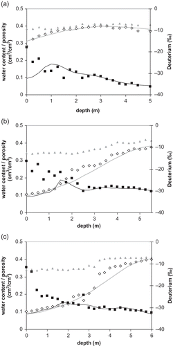
The Teacher Mante site (99 m a.s.l.) is also situated in the Cape Coast Granite Complex and in the middle of the basin. Cassava was grown at this site, and a mean root depth of 20 cm was observed. The texture was homogeneous throughout the entire depth (<5 m) and samples comprised 32(±2)% sand, 50(±2)% silt and 18(±2)% clay. The porosities ranged from 0.34 near the surface to 0.41 at 5.5 m ((b)).
The Ayikae Doblo site (43 m a.s.l.) represents the southern part of the basin and is located in the Togo Series. This site is covered by grass with mean root depth of 10 cm. The sample texture was homogeneous throughout the entire depth (<6 m), comprising 32(±2)% sand, 50(±1)% silt and 18(±1)% clay. The porosities were about 0.34 in the upper 3 m and 0.41 below that depth ((c)).
Generally, all characteristics of the profiles are similar and homogeneous in terms of porosity and texture. Clay content at the Adwumoku site was, on average, 8% greater than at the other two sites. Fractures were not visually noticed. Surface runoff is negligible due to the flat geomorphology.
At all three sites, the volumetric water content was smallest at the surface and increased with depth (). The water content at the Adwumoku site was greatest: close to saturation conditions with values of 0.28. This profile was saturated below a depth of 1.5 m, indicating a great air entry value (capillary fringe rise) compared to the static water level (5 m). The greater water content compared to the other sites might result from higher clay content (+8%) or from a greater infiltration rate. The Teacher Mante and Ayikae Doblo sites yielded similar results for porosity and water content. Both had low water contents near the surface (0.11 and 0.10) indicating no recharge during sampling as no wetting front was observed.
Precipitation and soil water
The monthly precipitation ranged from 0 to 371 mm. The driest period was between November and February (). The rainfall distribution in the catchment was not uniformly distributed, with the northern portion (Kibi) receiving more precipitation than in the central and southern areas (Nsawan). The mean value of rainfall was 1737 mm/year in the northern and 1310 mm/year in the central and southern areas during the observation period.
Fig. 3 Monthly precipitation and deuterium content of the two meteorological stations at Kibi and Nsawan; the isotope contents were measured in Kibi precipitation.
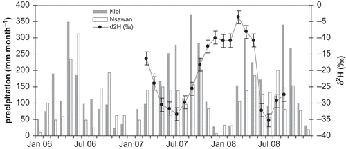
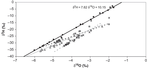
The isotope compositions of 18O and 2H in precipitation were more enriched in January and more depleted in July (). The values ranged from –1.73 to –6.01‰ and –2.8 to –35.3‰, respectively. The Local Meteoric Water Line (LMWL) and the isotope compositions of the soil water of the three sites (Adwumoku, Teacher Mante and Ayikae Doblo) are given in . The monthly composition in precipitation was close to the Global Meteoric Water Line (δ2H = 8δ18O + 10; Clark & Fritz, Citation1997). The pore water samples of the three sites plotted below the LMWL. Different regression lines indicate differences in water isotope transport at the three sites. Generally, the ratios at the Adwumoko site were more depleted and suggest greater contribution of winter precipitation to replenishment compared to the other sites. The regression lines from the Adwumoko and Ayikae Doblo sites deviate slightly from to the LMWL, which is attributed to enrichment due to evaporation. Neglecting the two samples close to the surface and close to precipitation compositions at the Teacher Mante site, the regression line resulted in a line parallel to the LMWL. Mixing of evaporated pre-existing soil water (e.g. groundwater) with new infiltrating water can result in a water line parallel to the LMWL (Clark & Fritz, Citation1997). However, it is not assumed that this effect predominated, as capillary rise seems not to influence the water content throughout the entire depth of the profile. Another reason might be that the isotope composition at the Kibi station (320 m a.s.l.) was not representative of the whole catchment. An altitude effect can result in more enriched precipitation ratios at lower altitudes and can cause the differences found in the pore water composition at the Ayikae Doblo site (43 m a.s.l.). Assuming such an effect would indicate δ18O (δ2H) altitude gradients of about –0.1‰ (–2.5‰) per 100 m, which is similar to those reported in a study in West Africa that yielded a δ18O altitude gradient of –0.155‰ per 100 m (Fontes & Olivry, Citation1977).
Fig. 4 The isotope composition of precipitation (•) with the local Meteoric Water Line (LMWL, –––) and the isotopic composition and regression lines of the soil water at the sites: Adwumoku (Δ, –––), Teacher Mante (![]()
In all measured water isotope depth profiles (), a general trend of isotope depletion with depth was observed. Water sampled near the surface was more enriched. This was due to vapour transport (evaporation effect), which was the dominant factor in this upper soil zone. As a result, the δ18O and δ2H contents were relatively enriched due to non-equilibrium effects, which resulted from the preferential loss of the lighter isotopes in the vapour phase. This evaporation effect is not restricted to the upper centimetres and penetrates into the soil, due to capillary effects and the relatively fast molecular exchange rates between soil water vapour and liquid. Generally, evaporation effects have been observed to penetrate to a depth of about 0.5–3 m (DePaolo et al., Citation2004), depending on the evaporation rate, soil type and the amount of time between infiltration events (Barnes & Allison, Citation1988; Mathieu & Bariac, Citation1996).
Small seasonal variations in the isotope contents of the soil water were observed in all soil profiles down to 2.75 m; these were more muted at the Ayikae Doblo site. Below this depth, no seasonal variations were observed and the water isotope content was constant or slightly decreasing. The attenuation of the seasonal signal was either caused by small flow velocity favouring diffusive flow, or it was the result of greater longitudinal dispersion compared to flow velocity. The fact that the isotope contents are slightly decreasing with depth suggests that some of the pore water was exchanged with more depleted groundwater. This could be caused by capillary rise, groundwater table fluctuations, upward fluxes due to evapotranspiration, or lateral water flow of more depleted water. However, no further evidence is given and generally, such processes remain unsolved as temporal sampling resolutions of depth profiles are lacking.
Groundwater recharge estimations
The HYDRUS 1D model (Simunek et al., Citation2005) was used to calculate the groundwater recharge based on transient flow and transport. The calculations were performed on a monthly basis (between 2006 and 2008) and a spatial discretization of 6 cm. As upper boundary conditions, the “atmospheric boundary condition with surface layer” was selected for the flow and the “concentration flux” for the solute transport. The lower boundary conditions were “seepage face” and “concentration”, respectively. Assuming equilibrium flow at the bottom, the measured distance of the lower boundary to the static water level was used as pressure head for the seepage face, which is 0, –50, and –70 cm for the sites Adwumoku, Teacher Mante and Ayikae Doblo, respectively. The roots were equally distributed over depth and the mean observed root depth was applied considering root water uptake.
The soil hydraulic parameters were determined assuming gravimetric equilibrium of the water contents with depth during the observation in June/July 2008 (). The measured water contents and isotopes were used to fit K s and αL. However, these values should only be considered as an order of magnitude, because little information about the profiles was available.
Table 1 Soil hydraulic parameters of the three study sites
The value of K s was in the same range for all the three profiles (205–274 cm d-1). A larger air-entry point (lower alpha) was assumed for the Adwumoku site based on the measured water contents, which showed greater saturation conditions near the surface as compared to the Teacher Mante and Ayikae Doblo sites (). The results of the flow modelling showed that the modelled water contents are in accordance with the measured values in all the three soil profiles (). Differences can result from local heterogeneities or from extremely large daily rainfall events that were not considered in using monthly input data.
Concerning the isotope transport, the greatest αL was estimated for the Adwumoku site. It must be pointed out that any fractionation of isotopes due to evaporation is not considered in these calculations. Therefore, the outcome of the isotope modelling near the surface should be taken with care when it results in differences between measured and modelled isotope contents.
However, this also enabled a potential evaporation depth to be tracked, where the soil water had undergone kinetic fractionation. The smallest difference near the surface was achieved in the Adwumoku site profile, suggesting a smaller evaporation depth (about 0.75 m). This was supported by the isotope composition of the pore water, which yielded a smaller slope of the regression line compared to Teacher Mante and, thus, indicated less evaporation effect. At the Teacher Mante and Ayikae Doblo sites, the modelled and measured isotope contents showed differences down to 1.75 m that might result from evaporation. Except for the evaporation effect, preferential flow of intense summer precipitation events could have resulted in differences between modelled and measured isotope contents.
The flow and transport modelling was performed for a three year period (2006–2008). It yielded mean fluxes at the lower boundary of 101 (±1–7%), 94 (±1–4%), and 182 (±1–3%) mm/year, for the sites Adwumoku, Teacher Mante and Ayikae Doblo, respectively (). At all three sites, the largest groundwater recharge was determined for October (data not shown). The uncertainty of this method was determined by varying the hydraulic conductivity by one order of magnitude and the other parameters of the water retention function by 10%. The low uncertainties (1–7%) emphasize the reliability of this method. Particularly when soil physical parameters are measured in the field, an uncertainty <5% can be assumed.
Table 2 Mean annual groundwater recharge (mm/year) resulting from transient flow and transport modelling, the approximate peak-shift method, and the water balance at the three observation sites in the Densu River basin
The greatest groundwater recharge rate (182 mm/year) was calculated for the Ayikae Doblo site located downstream in the Densu River basin at lower altitude, and this represented 13.9% of the annual precipitation of the closest weather station (1310 mm/year). At the Teacher Mante site, 7.2% (94 mm/year) of the precipitation contributed to the groundwater recharge. The Adwumoko site, had a similar groundwater recharge rate (101 mm/year); being located in the same geology but at higher altitudes with higher annual precipitation (1737 mm/year), this groundwater recharge represents 5.8% of precipitation.
Besides numerical modelling, a simple peak-shift method (
Equationequation (4)(4)) was applied to determine mean groundwater recharge rates. Water fluxes calculated for the three profiles at the Adwumoku, Teacher Mante and Ayikae Doblo sites were 250 (±10–30%), 120 (±10–30%) and 110 (±10–30%) mm/year, respectively (). Assuming an inaccuracy of water content measurements (±10%) or depth measurements (±25 cm) would result in a relative uncertainty of 10–30% for the results of the peak-shift method. Although this method results in higher uncertainties compared to numerical modelling, it still gives good approximations; besides, the uncertainty can be reduced by taking samples with higher vertical depth resolutions.
The fluxes were greatest for the Adwumoku site and smallest for the Ayikae Doblo site. The values for the Adwumoku site resulted from greater water content measurements. However, high water contents do not automatically imply high fluxes concerning transient, unsaturated conditions. Here, the soil hydraulic properties play a crucial role. Water fluxes can be small, resulting from small conductivities, although water contents are high. Further, assuming that some of the water at the Adwumoku site was immobile (θim = 0.1) would have resulted in smaller recharge rates (180 mm/year), because the effective water content is then smaller than the measured amount (Θ – θim; Equationequation (4)(4)). Immobile water or less mobile water cannot be excluded at the sites, but seems more likely for the Adwumoku site which has greater clay fractions (26%) than the other sites (18%). In addition, the water contents at the Teacher Mante and Ayikae Doblo sites were small near the surface, which indicated that immobile fractions were smaller than 0.1.
In general, the peak-shift method is simple and does not require an extensive amount of data. It gives a general trend of mean fluxes (recharge) as it is based on steady-state assumptions and the fact that advective flow is the predominant process. This is supported by the fact that the main infiltration was during a short time period and dispersion and diffusion seem to be less prominent compared to the water flow velocity. Therefore, the seasonal variation is still detectable with depth and the main peaks are distinguishable.
One main difference between the two methods applied for recharge estimation is the depth at which the calculated fluxes are valid. The numerical modelling accounts for the fluxes at the lower boundary, which was (almost) equal to the groundwater table (between 0 and 70 cm above the groundwater table). However, the peak-shift method can only consider mean fluxes in the upper soil profile where the seasonal isotope variations are still measurable. Therefore, the mean fluxes are only valid to a depth of 2–3 m. As this soil zone seems to be still influenced by evapotranspiration, the actual groundwater recharge rates can be overestimated or underestimated depending on the actual measured water contents and, therefore, the amount of precipitation and evapotranspiration at a specific point of time.
As already mentioned, immobile water and preferential flow are unaccounted for by the peak-shift method; they would have resulted in different groundwater recharge rates. The transient calculations at least allowed greater or smaller fluxes near saturation or at lower water contents, respectively. However, preferential flow, which is particularly initiated when the porous media is saturated, is more likely at the Adwumoku site due to the depth distribution of water contents. Although no major fractures were visible near the surface and because preferential flow is not merely restricted to saturated conditions, flow in macropores or cracks cannot be completely excluded.
In , the groundwater recharge rates are also given that were determined from the water balance while neglecting surface runoff and only considering the crop or reference evapo transpiration for the specific plants at the three sites. Thus, the groundwater recharge was determined from the difference of precipitation and crop (or reference) evapotranspiration. These values underestimated the actual groundwater recharge, because soil water stress conditions were neglected and the actual evapotranspiration was smaller than the calculated crop (or reference) evapotranspiration. Besides, crop coefficients are empirical parameters representing standard crops under typical growing conditions (Allen et al., Citation1998) and these can vary according to the actual vegetation development.
Considering the whole catchment area, a mean water budget was calculated using data of the Densu River basin from the Ghana Meteorological Services Department for the years 1965–2008. Mean values of precipitation (1338 mm/year), potential evapotranspiration (Hargreaves method; 948 mm/year), and runoff (117 mm/year) resulted in a mean groundwater recharge of 273 mm/year.
Independent of the model approach, the groundwater recharge in the Densu River basin calculated using water isotopes was comparable to findings of other studies in Ghana. Tumbulto (Citation2005) determined mean recharge rates in the Densu River basin over a 5-year period using a water balance approach. Differences between precipitation and both potential evapotranspiration and surface runoff resulted in a groundwater recharge of 133 mm/year, which was 14% of the mean annual precipitation.
In the Volta basin, which is further northeast, bordering the Densu basin, slightly smaller groundwater recharge rates were found using different methods (Obuobie, Citation2008). Here, 7–8% (70–92 mm/year) of the annual precipitation (2006–2007) contributed to the groundwater recharge, which was determined from water table fluctuation measurements and integrated over the observation area. A chloride mass balance approach yielded long-term groundwater recharge rates of 8% of precipitation (82 mm/year), and SWAT model results indicated that 7% of the precipitation was recharged in the Volta basin (Obuobie, Citation2008).
SUMMARY AND CONCLUSION
This study used water isotopes δ18O and δ2H to describe qualitatively and quantitatively the water transport in the unsaturated zone. The isotopes were shown to be useable to estimate groundwater recharge mechanisms and rates in the Densu River basin, Ghana. At all three investigated sites, evaporation influenced the isotope composition in the soil water in the upper 2–3 m. Differences were observed in the water contents and isotopes with depth that derived from different fluxes in the unsaturated zone. Concerning the results of transient flow and transport modelling, 6–14% of the precipitation contributed to the groundwater recharge in the catchment area that is 94–182 mm/year (±1–7%). Slightly different values, 110–250 mm/year (±10–30%), were calculated using an isotope peak-shift method, corresponding to 11–14% of the precipitation. The similarity in the results of both methods emphasizes the reliability of the simple peak-shift method, which is easily applied under field conditions even if a good database is not available.
Both methods can be improved by taking at least two distinct observation times: before and after the rainy season. Additionally, measuring chloride data and hydraulic properties or actual evapotranspiration rates can help to elucidate transport in the unsaturated zone or groundwater recharge rate estimation based on the water balance. This will enable the prediction of groundwater recharge rates with higher accuracy and should be considered in future studies in addition to water isotope analysis in pore water.
The amount of water recently pumped in the basin was 5.9 hm3/year (WRC, Citation2007). Extrapolating the results for the three sites to the whole basin, and assuming a mean groundwater recharge of 100 mm/year, results in 256 hm3/year of renewable water that could be available. Based on the calculated groundwater recharge rates, there seems, theoretically, to be enough water in the Densu River basin to provide sufficient drinking and irrigation water for the population to date. However, one should keep in mind that this amount refers to the whole area of the basin; wells are located in hotspots in the populated areas, and the amounts abstracted may exceed the replenishment, resulting in local overexploitation. Further, this is a mean annual value for the whole catchment. As has been shown, groundwater recharge rates vary spatially; also, less recharge can be expected during dry periods. It should also be noted that only a small fraction of groundwater (recharge) is used for drinking and irrigation purposes, while groundwater also contributes to river discharge. This theoretical, integrative consideration presumes that all groundwater resources are clean, accessible for drinking or irrigation water purposes, and that the registered numbers for consumption are correct and equal to the actual abstraction values. Thus, a great groundwater recharge does not automatically ensure sufficient water supply. Finally, the quantity alone is not the crucial point, but both the quantity and the quality. Some rivers and streams are already highly polluted due to poor agricultural practices in this region. With an increasing trend of the population, this topic will be even more relevant in the future. The results of this study can improve the accuracy of future groundwater management and development schemes to guarantee a sustainable use of groundwater in the Densu River basin, Ghana.
Acknowledgements
The authors are very grateful to the Director of the National Nuclear Research Institute, Ghana Atomic Energy Commission and the International Atomic Agency for making funds available for this work. We also thank the Technicians of the Chemistry Department, GAEC and the HMGU-Institute of Groundwater Ecology in Munich, Germany, for help during the sampling campaigns as well as in analysis. Further, we thank Prof. Stefan Uhlenbrook and another anonymous reviewer for their valuable comments which helped to improve the manuscript. Partial support of this work through EU Genesis project no. 226536 (FP7-ENV-2008-1) is kindly acknowledged.
Related Research Data
REFERENCES
- Abbot , M. D. , Lini , A. and Bierman , P. R. 2000 . δ18O, δD and 3H measurements constrain groundwater recharge patterns in an upland fractured bedrock aquifer, Vermont, USA . J. Hydrol. , 228 : 101 – 112 .
- Allen , R. G. , Pereira , L. S. , Raes , D. and Smith , M. 1998 . “ Crop evapotranspiration – guidelines for computing crop water requirements ” . In FAO Irrig. Drainage Paper 56 , Rome : FAO .
- Allison , G. B. and Barnes , C. J. 1983 . Estimation of evaporation from non-vegetated surfaces using natural deuterium . Nature , 301 : 143 – 145 .
- Allison , G. B. and Barnes , C. J. 1985 . Estimation of evaporation from the normally “dry” Lake Frome in South Australia . J. Hydrol. , 78 : 229 – 242 .
- Araguáus-Araguáus , L. , Rozanski , K. , Gonfiantini , R. and Louvat , D. 1995 . Isotope effects accompanying vacuum extraction of soil water for stable isotope analyses . J. Hydrol. , 168 : 159 – 171 .
- Barnes , C. J. and Allison , G. B. 1988 . Tracing of water movement in the unsaturated zone using stable isotopes of hydrogen and oxygen . J. Hydrol. , 100 : 143 – 176 .
- Barnes , C. J. and Turner , J. V. 1998 . “ Isotopic exchange in soil water ” . In Isotope Tracers in Catchment Hydrology , Edited by: Kendall , C. and McDonnell , J. J. 137 – 164 . Amsterdam : Elsevier .
- Barnes , C. J. and Walker , G. R. 1989 . The distribution of deuterium and oxygen-18 during unsteady evaporation from a dry soil . J. Hydrol. , 112 : 55 – 67 .
- Blake , G. R. and Hartge , K. H. 1986 . “ Bulk density ” . In Methods of Soil Analysis Physical and mineralogical methods , 2nd Edited by: Klute , A. 363 – 375 . Part IAgronomy Monograph no. 9
- Clark , I. D. and Fritz , P. 1997 . Environmental Isotopes in Hydrology , Boca Raton, FL : Lewis Publishers .
- Coleman , M. L. , Shepherd , T. J. , Durham , J. J. , Rouse , J. E. and Moore , G. R. 1982 . Reduction of water with zinc for hydrogen isotope analysis . Anal. Chem. , 54 : 993 – 995 .
- Coplen , T. B. 1988 . Normalization of oxygen and hydrogen isotope data . Chem. Geol. , 72 : 293 – 297 .
- Darling , W. G. and Bath , A. H. 1988 . A stable isotope study of recharge processes in the English Chalk . J. Hydrol. , 101 : 31 – 46 .
- DePaolo , D. J. , Conrad , M. E. , Maher , K. and Gee , G. W. 2004 . Evaporation effects on oxygen and hydrogen isotopes in deep vadose zone pore fluids at Hendford, Washington . Vadose Zone J. , 3 : 220 – 232 .
- Dickson , K. B. and Benneh , G. 1998 . A New Geography of Ghana , 27 – 52 . Harlow : Longman Group UK Ltd .
- Epstein , S. and Mayeda , T. K. 1953 . Variations of 18O content of waters from natural sources . Geochim. Cosmochim. Acta , 4 : 213 – 224 .
- Fontes , J. Ch. and Olivry , J. C. 1977 . “ Gradient isotopique entre 0 et 4000 m dans les précipitations du Mont Cameroun ” . In C. R. Réunion Annuelle Sci. de la Terre , Paris : Soc. Geol. Française .
- Fontes , J. Ch. , Yousfi , M. and Allison , G. B. 1986 . Estimation of long-term, diffuse groundwater discharge in the northern Sahara using stable isotope profiles in soil water . J. Hydrol. , 86 : 315 – 327 .
- Gazis , C. and Feng , X. 2004 . A stable isotope study of soil water: evidence for mixing and preferential flow paths . Geoderma , 119 : 97 – 111 .
- Geake , A. K. and Foster , S. S. D. 1989 . Sequential isotope and solute profiling in the unsaturated zone of British Chalk . Hydrol. Sci. J. , 34 : 79 – 95 .
- Ghana Statistical Service . 2002 . Population and housing census. Summary report on final results , Accra : Medialite co. Ltd .
- Hillel , D. and Gardner , W. R. 1970 . Measurement of unsaturated hydraulic conductivity by infiltration through an impeding layer . Soil Sci. , 109 : 149 – 153 .
- Hopmans , J. W. , Simunek , J. , Romano , N. and Durner , W. 2002 . “ Inverse methods ” . In Methods of Soil Analysis , 3rd , Edited by: Dane , J. H. and Topp , G. C. 963 – 1008 . Madison, WI : Soil Science Society of America . Part 4. Physical methods
- Hsieh , J. C. C. , Chadwick , O. A. , Kelly , E. F. and Savin , S. M. 1998 . Oxygen isotopic composition of soil water: quantifying evaporation and transpiration . Geoderma , 82 : 255 – 268 .
- Junner , N. R. 1935 . Gold in the Gold Coast . Mem. Gold Coast Geol. Surv. 4 ,
- Junner , N. R. 1940 . Geology of the Gold Coast and Western Togoland . Gold Coast Geol. Surv. Bull. , 10
- Leibundgut , C. , Maloszewski , P. and Külls , C. 2009 . Tracers in Hydrology , 37 Chichester : John Wiley & Sons Ltd .
- Leube , A. and Hirdes , W. The Birimian Supergroup of Ghana – depositional environment, structural development and conceptual model of an early Proterozoic suite . Rep. Arch. BGR 99529 . 1986 .
- Maloszewski , P. , Maciejewski , S. , Stumpp , C. , Stichler , W. , Trimborn , P. and Klotz , D. 2006 . Modelling of water flow through typical Bavarian soils based on lysimeter experiments: 2. Environment deuterium transport . Hydrol. Sci. J. , 51 : 298 – 313 .
- Mathieu , R. and Bariac , T. 1996 . An isotopic study (2H and 18O) of water movements in clayey soils under a semiarid climate . Water Resour. Res. , 32 : 779 – 789 .
- McConville , C. , Kalin , R. M. , Johnston , H. and McNiell , G. W. 2001 . Evaluation of recharge in a small temperate catchment using natural and applied 18O profiles in the unsaturated zone . Ground Water , 39 : 616 – 623 .
- McGuire , K. J. , DeWalle , D. R. and Gburek , W. J. 2002 . Evaluation of mean residence time in subsurface waters using oxygen-18 fluctuations during drought conditions in the mid-Appalachians . J. Hydrol. , 261 : 132 – 149 .
- Millington , R. J. and Quirk , J. P. 1961 . Permeability of porous solids . J. Faraday Soc. , 57 : 1200 – 1206 .
- Consult , Nii . 2001 . Rapid environmental assessment and action planning of Densu River basin in Ghana . A consultancy report. A United Nations Center for Human Settlement (Habitat) and Water Resources Commission of Ghana funded, Accra, March, 2001 ,
- O'Driscoll , M. A. , DeWalle , D. R. , McGuire , K. J. and Gburek , W. J. 2005 . Seasonal 18O variations of groundwater recharge for three landscape types in central Pennsylvania, USA . J. Hydrol. , 303 : 108 – 124 .
- Obuobie , E. 2008 . Estimation of groundwater recharge in the context of future climate change in the White Volta River basin , Germany : Rheinischen Friedrich-Wilhelms-Universität Bonn . West Africa. Dissertation
- Reedy , M. M. , Schuster , P. , Kendall , C. and Reedy , M. B. 2006 . Characterization of surface and groundwater δ18O seasonal variation and its use for estimating groundwater residence times . Hydrol. Processes , 20 : 1753 – 1772 .
- Richards , C. A. 1931 . Capillary conduction of Liquids through porous media . Physics , 1 : 318 – 318 .
- Shukla , S. , Mostaghimi , S. , Shanholtz , V. O. and Collins , M. C. 1998 . A GIS-based modeling approach for evaluating groundwater vulnerability to pesticides . J. Am. Water Resourc. Assoc. , 34 : 1275 – 1293 .
- Simunek , J. , Šejna , M. and van Genuchten , MTh. 2005 . Version 3.0, HYDRUS Software Series 1: The HYDRUS-1D software package for simulating the one-dimensional movement of water, heat and multiple solutes in variably-saturated media , Riverside, CA : Department of Environmental Sciences, University of California Riverside .
- Stumpp , C. , Maloszewski , P. , Stichler , W. and Maciejewski , S. 2007 . Quantification of heterogeneity of the unsaturated zone based on environmental deuterium observed in lysimeter experiments . Hydrol. Sci. J. , 52 : 748 – 762 .
- Stumpp , C. , Maloszewski , P. , Stichler , W. and Fank , J. 2009a . Environmental isotope (δ18O) and hydrological data to assess water flow in unsaturated soils planted with different crops: case study lysimeter station “Wagna” Austria . J. Hydrol. , 369 : 198 – 208 .
- Stumpp , C. , Stichler , W. and Maloszewski , P. 2009b . Application of the environmental isotope δ18O to study water flow in unsaturated soils planted with different crops: case study of a weighable lysimeter from the research field in Neuherberg, Germany . J. Hydrol. , 368 : 68 – 78 .
- Tumbulto , J. W. 2005 . A study of water balance in the Pompon sub-catchment of the Densu River basin , Legon, Ghana : Department of Geology, University of Ghana . Dissertation (PhD)
- van Genuchten , M. Th. 1980 . A closed-form equation for predicting the hydraulic conductivity of unsaturated soils . Soil Sci. Soc. Am. J. , 44 : 892 – 898 .
- WRC (Water Resources Commission) . 2007 . Integrated water resources management plan – Densu River basin ,
- WRI (Water Research Institute) . 1994 . Borehole Yield Map of Ghana , Accra : Water Research Institute . 1:500 000