Abstract
The aim of this paper is to quantify meteorological droughts and assign return periods to these droughts. Moreover, the relation between meteorological and hydrological droughts is explored. This has been done for the River Meuse basin in Western Europe at different spatial and temporal scales to enable comparison between different data sources (e.g. stations and climate models). Meteorological drought is assessed in two ways: using annual minimum precipitation amounts as a function of return period, and using troughs under threshold as a function of return period. The Weibull extreme value type 3 distribution has been fitted to both sources of information. Results show that the trough-under-threshold precipitation is larger than the annual minimum precipitation for a specific return period. Annual minimum precipitation values increase with spatial scale, being most pronounced for small temporal scales. The uncertainty in annual minimum point precipitation varies between 68% for the 30-day precipitation with a return period of 100 years, and 8% for the 120-day precipitation with a return period of 10 years. For spatially-averaged values, these numbers are slightly lower. The annual discharge deficit is significantly related to the annual minimum precipitation.
Citation Booij, M. J. & de Wit, M. J. M. (2010) Extreme value statistics for annual minimum and trough-under-threshold precipitation at different spatio-temporal scales. Hydrol. Sci. J. 55(8), 1289–1301.
Résumé
Le but de cet article est de quantifier les sécheresses météorologiques et de leur attribuer des périodes de retour. De plus, la relation entre les sécheresses météorologiques et hydrologiques est explorée. Cela a été appliqué au bassin du Fleuve Meuse en Europe Occidentale, à différentes échelles spatiales et temporelles, ce qui permet de comparer les résultats obtenus à partir de différentes sources de données (e.g. stations de mesure et modèles climatiques). La sécheresse météorologique est estimée selon deux manières: à partir des précipitations minimales annuelles en fonction de la période de retour, et à partir des creux inférieurs à un seuil en fonction de la période de retour. La distribution des valeurs extrêmes de Weibull de type 3 a été ajustée aux deux sources d'information. Les résultats montrent que, pour une période de retour donnée, le creux de précipitation inférieur à un seuil est supérieur au minimum annuel de précipitation. Les valeurs de précipitation minimale annuelle augmentent avec l'échelle spatiale, tout en étant les plus prononcées pour les petites échelles temporelles. L'incertitude de la précipitation minimale annuelle ponctuelle varie entre 68% pour une durée de 30 jours et une période de retour de 100 ans, et 8% pour une durée de 120 jours et une période de retour de 10 ans. Pour les valeurs moyennes dans l'espace, ces valeurs sont légèrement inférieures. Le déficit d'écoulement annuel est significativement lié à la précipitation minimale annuelle.
INTRODUCTION
Droughts influence many aspects of the environment and society, and to a varying degree, affect some parts of the world every year (Hisdal & Tallaksen, Citation2003). They are costly natural disasters, causing an average US$6–8 billion in global damages annually and collectively affecting more people than any other form of natural disaster (Keyantash & Dracup, Citation2002). Increasing demands for water in future will be most critical in periods of severe drought. Droughts in Europe are not restricted to the Mediterranean region, but can occur in high and low precipitation areas in any season. Recent severe and prolonged droughts have highlighted Europe's vulnerability to this natural phenomenon and alerted stakeholders to the many problems accompanying water shortage and to the need for drought mitigation measures (Lloyd-Hughes & Saunders, Citation2002). Projected climate changes are expected to lead to drier summers in Western Europe (e.g. Schär et al., Citation2004) and consequently even more severe droughts, although Hisdal et al. (Citation2001) have shown that drought conditions in Europe in general have not become more severe or frequent in the last century. They based their findings on the daily streamflow records of more than 600 stations in Europe.
Drought is a natural phenomenon resulting from the occurrence of less than normal precipitation for an extended period of time (Smakhtin, Citation2001). Four types of drought are generally considered: meteorological, hydrological, agricultural and socio-economic. The latter type can be considered as a consequence of the other drought types. The three physical drought types are associated with a deficiency in a characteristic hydrological variable, e.g. precipitation deficit for meteorological drought and discharge deficit for hydrological drought. Discussion of different drought definitions can be found in Dracup et al. (Citation1980), Wilhite & Glantz (Citation1985) and Keyantash & Dracup (Citation2002). The focus in this paper will be on meteorological droughts for which indices are primarily based on precipitation deficits. Although precipitation is the primary factor controlling the formation and persistence of drought conditions, evapotranspiration is also an important variable. However, due to difficulties in quantifying evapotranspiration rates, indices based solely on precipitation are preferred and perform well when compared with more complex hydrological indices (Lloyd-Hughes & Saunders, Citation2002). These precipitation indices are mainly based on anomalies from normality, see e.g. the Palmer drought severity index (Palmer, Citation1965), the standardized precipitation index (McKee et al., Citation1993) and the drought area index (Bhalme & Mooley, Citation1980). In order to assign probabilities and return periods to meteorological droughts, extreme value distributions can be fitted to annual precipitation deficits or precipitation deficits exceeding a certain threshold (e.g. Beersma & Buishand, Citation2007). Applications to hydrological drought are more frequent (e.g. Hisdal et al., Citation2001; Zaidman et al., Citation2003), as are those to the opposite phenomena such as extreme precipitation and floods. Statistical frequency analyses using annual minimum values are common in hydrological drought analysis (low flows) (for an extensive overview see Smakhtin, Citation2001), but less common for meteorological droughts.
Meteorological drought indices in a changed climate can be assessed using data from Global Climate Models (GCMs) and Regional Climate Models (RCMs). Assessments of these indices for current climate conditions are mostly based on point precipitation from stations. Upscaling techniques need to be applied in order to compare these point data with spatially-averaged GCM and RCM data. For common precipitation statistics, relations between the statistic and spatial scale have been derived, e.g. for the standard deviation of daily precipitation, the wet day frequency (Osborn & Hulme, Citation1997) and annual maximum precipitation for different return periods (Sivapalan & Blöschl, Citation1998). These relations enable comparison between observed point precipitation and spatially-averaged modelled precipitation for current climate conditions, and subsequently assessment of climate change impacts on precipitation using GCM and RCM results for current and changed climate conditions. Upscaling (and downscaling) relations for meteorological drought indices are not known to the authors, but are a prerequisite for climate change impact assessment in this field. Meteorological drought indices assessed at different spatial scales are a first step towards such generalized scaling relations.
Based on the preceding considerations, the aim of this paper is to determine extreme value statistics for annual minimum precipitation and trough-under-threshold precipitation at different spatial scales and different temporal scales. Additionally, the uncertainty in the extreme value statistics as a result of sampling and extrapolation is assessed, and the relation between annual minimum precipitation and hydrological drought is investigated. The study area is the River Meuse basin in Western Europe. This river is used to supply water to about 6 million people in Belgium and the Netherlands. Over the last decades the demand for water of good quality has increased with economic development and population growth. Moreover, there is a tendency in the Netherlands to exploit surface water instead of groundwater. Furthermore, the Meuse fulfils an important link in the network of canals and rivers that connects the harbours of Antwerp and Rotterdam to the European hinterland. Given the existence of these multiple functions of the Meuse, consideration of droughts is justified. Meteorological droughts rather than hydrological droughts are considered here because, generally, precipitation data are available for longer periods and more stations compared to discharge data. The relation between meteorological and hydrological drought will reveal to what extent meteorological drought statistics can be used to assess hydrological drought. This relation is expected to become more significant for larger temporal scales of the meteorological drought, see also De Wit et al. (Citation2007). In this paper, first the data and methods are described, then the results are presented and discussed and, finally, conclusions are drawn.
DATA AND METHODS
River basin and data
The Meuse basin covers an area of approximately 33 000 km2, including parts of France, Luxembourg, Belgium, Germany and the Netherlands (see ). About 60% of the Meuse basin is used for agricultural purposes (including pasture) and 30% is forested. The average annual precipitation ranges from 1000 to 1200 mm in the higher parts of the basin to 700 to 800 mm in the Dutch and Flemish lowlands. The maximum altitude is just below 700 m a.m.s.l. Snowmelt is not a major factor for the discharge regime of the Meuse. The average discharge of the Meuse at the outlet is approximately 350 m3 s-1; this corresponds to an annual precipitation surplus of almost 400 mm. Precipitation is equally distributed over the year. The seasonal variation in discharge is a reflection of the variation in evapotranspiration (Booij, Citation2005). In this study, Borgharen (see , upstream area about 21 000 km2) is taken as the reference discharge station.
Fig. 1 Location and elevation of the Meuse basin upstream of Borgharen with precipitation stations indicated by white squares.
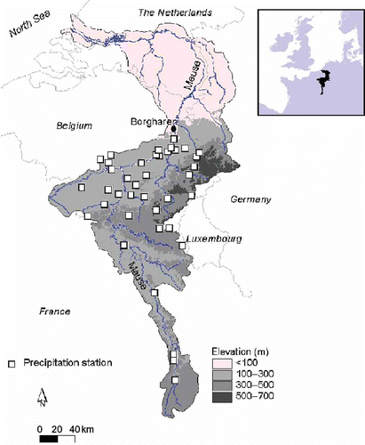
Daily precipitation and discharge data for the period 1970–1999 have been used. The precipitation data are from 39 stations in the Meuse basin in Belgium and France (see ) and have been provided by the KMI (Belgian Royal Meteorological Institute) and Météo France. Only observed precipitation series without missing data were used, which means that half of the available number of 78 stations could not be included. The discharge data are from one station (Borgharen) and have been provided by Rijkswaterstaat, the Netherlands. The Borgharen gauging station is located downstream of a river stretch where a number of canals branch off. The distribution of water between the canals and the Meuse is regulated and substantially affects the discharge at Borgharen, in particular during low flows. Therefore, a corrected (by Rijkswaterstaat) discharge series is used representing the “undivided” Meuse. This corrected record has been used in this study and is referred to here as Borgharencor. The annual average discharge of the “undivided” Meuse is 270 m3 s-1.
Extreme value statistics for annual minimum precipitation
It is assumed that annual minimum k-day precipitation, P min, stems from a Weibull (extreme value type 3) distribution with a probability density function:
The location parameter is equal to 0, because the minimum precipitation is assumed to be 0. Then, parameters α and λ can be determined using Equationequations (3)(3) and Equation(4)
(3). Precipitation T-year return values, RV(T), have been derived using Equationequation (2)
(2) and the equality T = 1/[1 – F(P
min)]:
The assumption that annual minimum values are Weibull distributed is tested with the simple, but powerful, probability plot correlation test (Filliben, Citation1975). This test uses the correlation between ordered (logarithmic) observations and the corresponding fitted quantiles, determined by plotting positions (probability plot correlation coefficient, PPCC). Values of PPCC near 1 suggest that the observations could have been drawn from the fitted distribution. The Gringorten plotting position (Gringorten, Citation1963) originally developed for the Gumbel distribution was used. Critical PPCC values were obtained from Stedinger et al. (Citation1993).
Extreme value statistics for troughs under threshold
Similarly to Önöz & Bayazit (Citation2002), who applied trough-under-threshold analysis to low flows in rivers, the Poisson distribution has been used to describe the occurrence of minima under the threshold and the power distribution has been used to describe the magnitude of these minima (see Önöz & Bayazit, Citation2001). Combination of these two distributions results in the two-parameter Weibull distribution (Önöz & Bayazit, Citation2002), i.e. Equationequation (2)(2) without the location parameter, which is the same distribution as used for annual minimum precipitation amounts since the location parameter is equal to 0. However, in the trough-under-threshold analysis, the parameters of the Weibull distribution are determined using the threshold values themselves, the average annual number of occurrences and the frequency distributions of the troughs under threshold:
The precipitation threshold, Pb , is chosen to be equal to the maximum of the annual minimum precipitation values for each temporal and spatial scale. This enables a fair comparison between the two methods for assessing meteorological drought. It might also show the possible added value of using troughs-under-threshold, i.e. when the resulting number of troughs under threshold exceeds the number of annual minimum precipitation values.
Annual minimum and trough-under-threshold precipitation at different temporal scales
For annual minimum precipitation, the k-day precipitation values, Pk (t), are determined by summing the daily precipitation values, P(t), of the actual day, t, and the preceding k – 1 days, starting at day number k in a particular calendar year, and up to and including day number T (=365 or 366, day number 1 is 1 January, etc.):
Droughts are expected to give most problems in summer and, therefore, a calendar year as opposed to a hydrological year is chosen. A total of (T – k + 1) k-day precipitation values are obtained for each year. The annual minimum k-day precipitation, P min(k), is the minimum of these values for each year. Annual minimum k-day precipitation values at different temporal scales are derived by varying k. Values for k should be neither too small, to avoid zero precipitation values which complicate the estimation of Weibull parameters, nor too large, to make sure that a seasonal signal is studied. Therefore a range of values for k was selected as follows: 30, 60, 90, 120, 150 and 180 days. Since the k-day precipitation values are determined within each calendar year, it is assumed that the central dates of occurrence of the annual minimum k-day precipitation values in successive years are independent and can be fitted to the Weibull distribution. Moreover, the independence of annual minimum k-day precipitation values in successive years is confirmed by comparison of the autocorrelation coefficient with a lag of 1 year with its critical value using a significance level of 0.05 (Zar, Citation1996). A disadvantage of this approach could be that meteorological droughts occurring around the turn of the year are not taken into account. The trough-under-threshold analysis can take these droughts into account because it considers the successive years as a continuous time series. For troughs under threshold, the k-day precipitation values, Pk (i), are determined by summing the daily precipitation values, P(t), of each period i of k days:
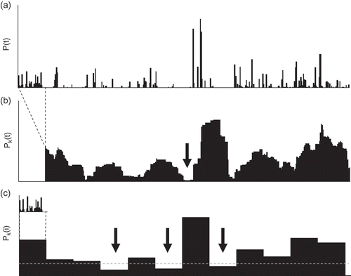
The trough-under-threshold k-day precipitation values, Pt (k), are the k-day precipitation values, Pk (i), below the precipitation threshold for each temporal scale, Pb (k). The independence of successive trough-under-threshold k-day precipitation values is confirmed by comparison of the autocorrelation coefficient with a lag of one trough occurrence with its critical value using a significance level of 0.05. illustrates the selection of annual minimum and trough-under-threshold k-day precipitation for one station in 1976. Obviously, the number of troughs (three) is larger than the number of annual minima (by definition equal to one) for this very dry year.
Fig. 2 (a) Example of daily precipitation series, P(t), for station Bierset in 1976; (b) illustration of the selection of annual minimum k-day precipitation, Pk (t), and (c) trough-under-threshold k-day precipitation, Pk (i), for k = 30 days. The arrows indicate the precipitation values selected for the extreme value analysis. The dashed line in (c) represents the threshold value.
Annual minimum precipitation at different spatial scales
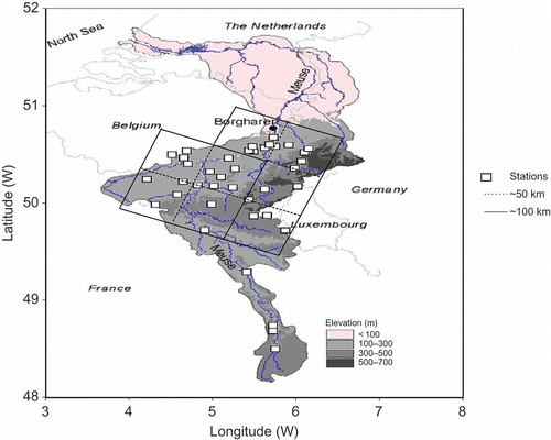
Meteorological drought at different spatial scales is assessed using annual minimum precipitation. Annual minimum k-day precipitation values at different spatial scales are obtained by first arithmetically averaging daily point precipitation values, P(t), for stations within areas of a certain size and subsequently following the same procedure as for the point precipitation values for this spatially-averaged precipitation. The areas for averaging steps 1 and 2 are shown in and are based on grid boxes of 0.44° × 0.44° (∼50 km). This grid size is similar to those used in regional climate models (e.g. Leander & Buishand, Citation2007). The areas correspond to spatial scales of, respectively, 50 and 100 km. In this way, 35 out of a total of 39 stations are taken into account in these two averaging steps. Averaging Step 3 results in the arithmetically-averaged precipitation for all stations in with a corresponding scale of 150 km. Thus, annual minimum k-day precipitation values at four different spatial scales (point, 50, 100 and 150 km) are obtained. The average precipitation k-day return values at the point, 50-km and 100-km scales are determined by averaging the 39 point values, and eight and two spatially-averaged values, respectively. The average precipitation k-day return values at the 150-km scale are obtained directly from the annual minimum k-day precipitation values at this spatial scale.
Fig. 3 Precipitation stations and areas for the averaging procedure for Step 1 resulting in a spatial scale of 50 km, and Step 2 resulting in a spatial scale of 100 km.
Uncertainties in annual minimum precipitation
The uncertainty in the annual minimum precipitation amounts as a function of return period is determined using parametric bootstrapping (Efron & Tibshirani, Citation1993). Here, 10 000 samples from the fitted Weibull distributions are generated for each temporal and spatial scale investigated and a selection of return values. As in the observed data series, each sample consists of 30-year sequences of annual minimum precipitation amounts. This enables an assessment of the uncertainty in annual minimum precipitation at different spatial and temporal scales, and for different return values. The uncertainty can be expressed as a probability density function, a confidence interval or simply as a standard deviation. The 90% confidence interval is determined using the 5 and 95% points corresponding to precipitation values with respectively rank 500 and rank 9500 (out of 10 000 ordered precipitation values).
Hydrological drought
Hydrological drought indices are mostly associated with a deficiency in water supply from, for example, rivers, reservoirs and aquifers. Keyantash & Dracup (Citation2002) compared several indices, such as the total water deficit, the Palmer hydrological drought severity index and the surface water supply index. Based on a multi-criteria analysis, they concluded that the total water deficit is the most appropriate index for hydrological drought. In this study, hydrological drought is characterized by an index similar to the total water deficit; the annual discharge deficit, ADD, in m3. This is the total annual amount of water shortage compared to a certain threshold:
RESULTS AND DISCUSSION
Extreme value statistics for annual minimum and trough-under-threshold precipitation
The PPCC test failed to reject the hypothesis of annual minimum k-day point precipitation being Weibull distributed at a significance level of 0.05 for 29 stations (or 74%) for k = 60 days, for 38 stations (or 97%) for k = 90 days, and for all 39 stations for k = 30, 120, 150 and 180 days. The 100% failure for a duration of 30 days is influenced by the large number of stations (21 out of 39) with 1, 2 or even 3 years with annual minimum 30-day precipitation amounts of 0 mm. These years have not been taken into account in the PPCC test. The PPCC test failed to reject the hypothesis of trough-under-threshold k-day point precipitation being Weibull distributed at a significance level of 0.05 for 30 stations for k = 30 days, 38 stations for k = 60 days, 39 stations for k = 90 days, 36 stations for k = 120 days, 33 stations for k = 150 days, and 37 stations for k = 180 days. Finally, the PPCC test failed to reject the hypothesis of annual minimum and trough-under-threshold k-day spatially-averaged precipitation being Weibull distributed at the same significance level of 0.05 for all durations. The average number of troughs under threshold used is 41 for point precipitation (varying between 37 for k = 30 and 120 days and 46 for k = 150 days) and 36 for spatially-averaged precipitation (varying between 27 for k = 120 days and 45 for k = 90 days), which shows the added value of using troughs under threshold compared to the 30 annual minimum precipitation values used.
Figure 4 shows the mean and range (minimum–maximum) of station observed annual minimum and trough-under-threshold k-day precipitation as a function of return period for two durations (30 and 120 days). The minimum and maximum are based on the minimum and maximum out of the 39 stations of the annual minimum and trough-under-threshold k-day precipitation for a return period of 10 years. Based on the Weibull parameter values (α and λ) for these two stations, the ranges shown in have been determined. For large return periods and small durations, ratios between maximum and minimum values are large (more than 10 for return periods of 50 and 100 years and 30-day duration) indicating a large spatial variability in annual minimum and trough-under-threshold k-day precipitation. This can be attributed to the point quantity measured and the inherent coincidence of catching a small or larger precipitation amount (sampling problem, statistical cause) and to the effect of orography (e.g. reasonable correlation with annual minimum 120-day precipitation for a return period of 10 years; correlation coefficient = 0.77) and distance to the sea (weak correlation; correlation coefficient = 0.36) (physical causes). For large durations, the effects of extreme events are averaged and therefore the variation between stations is much lower. Although ratios can be large, the corresponding differences between absolute precipitation values are rather small (e.g. 0.2 and 2 mm).
Fig. 4 Mean (solid line) and minimum and maximum (dotted line) of station observed annual minimum (black line) and trough-under-threshold (grey line) 30-day and 120-day precipitation as a function of return period (and Weibull reduced variate).
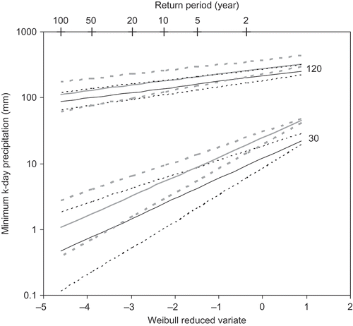
The trough-under-threshold precipitation is larger than the annual minimum precipitation for a specific return period. Differences increase with decreasing duration and to a lesser extent with increasing return periods. This difference can be attributed to the fact that, by definition and due to the temporal summation procedure, trough-under-threshold precipitation values are equal to or larger than the annual minimum precipitation values. The relationships between precipitation and return period using both methods are similar, i.e. the slopes (determined by Weibull parameter λ) of these relationships are comparable, while the intercepts (determined by Weibull parameter α) are quite different and cause the systematic difference between both methods.
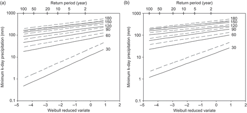
Annual minimum and trough-under-threshold precipitation at different temporal scales
Figure 5 shows the annual minimum and trough-under-threshold k-day station observed (point) and spatially-averaged (150-km scale) precipitation as a function of return period for six durations (k values). In general, it can be observed that the decrease of precipitation values with increasing return periods is more pronounced for small durations compared to large durations. This has to do with the temporal averaging effect for larger durations resulting in a smaller inter-annual variability in precipitation values and thus a larger value for the Weibull parameter, λ, finally leading to smaller slopes of the frequency curves in for larger durations (see also Equationequation (5)(5)). The relationships between λ and duration, k, are significant and of logarithmic nature (i.e. λ = a
1 ln(k) – b
1 with a
1 and b
1 being regression parameters). Those between α and k are significant as well and linear (i.e. α = a
2
k – b
2 with a
2 and b
2 regression parameters). The relationships for λ vary with different spatial scales, while those for α are more or less independent of spatial scale, because λ (as opposed to α) is dependent on the coefficient of variation of the annual minimum precipitation (S/M). The coefficient of variation is dependent on the spatial scale, i.e. the larger the spatial scale, the more averaging and the smaller the coefficient of variation. Also here, the trough-under-threshold precipitation is larger than the annual minimum precipitation for a specific return period.
Fig. 5 Mean of station observed (a) and spatially-averaged (b) annual minimum (solid black line) and trough-under-threshold (dashed grey line) k-day precipitation as a function of return period (and Weibull reduced variate) for k = 30, 60, 90, 120, 150 and 180 days.
The spatially-averaged annual minimum or trough-under-threshold precipitation shown in could be important for hydrological drought assessment. When considering these precipitation amounts for large return periods, it is clear that their values relative to the mean precipitation for a particular duration decrease with decreasing duration. However, this does not necessarily lead to critical low flows in the Meuse River because, in general, the most critical low flows in this river occur in years with subsequent dry winter half-years and dry summer half-years. Such critical low flow events have neither been observed in years when a dry winter was followed by a wet summer, nor in years when a wet winter was followed by a dry summer (De Wit et al., Citation2007). In principle, it is thus the joint probability of occurrence of small minimum precipitation amounts in winter and the successive summer that determines the critical low flows. Nevertheless, some relationships between minimum precipitation amounts and hydrological droughts can be identified as shown in the last results section.
Annual minimum precipitation at different spatial scales
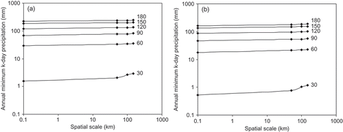
Annual minimum precipitation as a function of spatial scale for different durations and two return periods is given in . This shows that annual minimum precipitation values increase with spatial scale being most pronounced for small durations. The amplification of annual minimum precipitation with increasing spatial scale is neither related to seasonal effects (e.g. larger in summer with convective, small-scale precipitation) nor to the spatial variability of annual minimum precipitation amounts for a specific year. This amplification is opposite to the reduction of annual maximum precipitation with increasing spatial scale (see e.g. Booij, Citation2002, Citation2003). and more general amplification functions can be used to derive annual minimum spatially-averaged precipitation amounts for required spatial scales (e.g. specific catchments, climate model scales or remote sensing scales), durations and return periods based on available annual minimum point precipitation amounts.
Fig. 6 Annual minimum k-day precipitation as a function of spatial scale for k = 30, 60, 90, 120, 150 and 180 days for return values of 20 years (a) and 100 years (b).
Uncertainties in annual minimum precipitation at different temporal and spatial scales
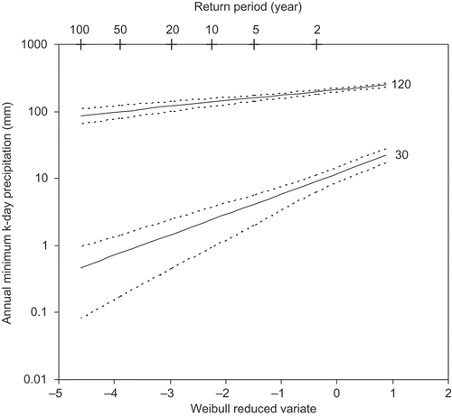
The uncertainty in annual minimum precipitation is shown in , where the annual minimum 30-day and 120-day point precipitation as a function of return period are plotted with the 90% confidence intervals. The uncertainty expressed as standard deviation relative to the mean value varies for point values between 68% for a duration of 30 days and a return period of 100 years and 8% for a duration of 120 days and a return period of 10 years. For spatially-averaged values (figures not shown to avoid redundancy), these figures are respectively 50 and 7%. Since the uncertainty is caused by sampling and extrapolation, it will be larger for larger return periods (as observed) and smaller sample sizes (not investigated). Moreover, it is found that the uncertainty increases with decreasing duration and spatial scale as can be expected because of temporal and spatial-averaging effects, respectively. The uncertainty also means that observed annual minimum precipitation values can correspond to a range of return periods (and vice versa), e.g. an annual minimum 30-day point precipitation of 1 mm could correspond to return periods differing by almost an order of magnitude (10–100 years, see ). The uncertainties for small durations are large compared to the uncertainty in annual maximum precipitation in the Meuse basin for the same return periods, while the uncertainty for larger durations (120 days and more) is comparable to or even smaller than the uncertainty in annual maximum precipitation (see Booij, Citation2002).
Fig. 7 Mean of station observed annual minimum 30-day and 120-day precipitation (solid line) and 90% confidence intervals (dotted line) as a function of return period (and Weibull reduced variate).
Annual minimum precipitation and hydrological drought
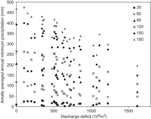
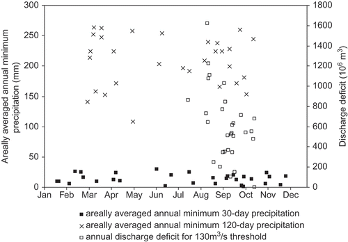
It was indicated earlier that low flows (occurring mainly at the end of the summer/beginning of the autumn) depend on the long-term preceding precipitation, in summer as well as in the preceding winter and spring. Nevertheless, shows reasonable relationships between the annual discharge deficit (ADD) and annual minimum spatially-averaged (150-km scale) precipitation for different durations. As expected, the relations become more significant for larger durations, as indicated by a range in the correlation coefficient of about 0.46 for 30 days, 0.72 for 60 days to about 0.86 for 180 days. The larger the time period, the more averaging and so the better the relationships between minimum precipitation and discharge deficit, similar to the better relationships between precipitation and river basin discharge with increasing time period. All these correlation coefficients are significant when applying a two-tailed test with a significance level of 0.05. The threshold discharge for the discharge deficit is chosen to be 130 m3 s-1 (about 50% of the average “undivided” Meuse discharge) corresponding to the starting phase for water allocation measures in The Netherlands and Belgium. The largest discharge deficit (∼1600 × 106 m3) was observed in 1976, one of the driest years in the measuring record (see De Wit et al., Citation2007). This discharge deficit is much larger than deficits observed in other years. In general (with the exception of k = 30 and k = 60 days), the smallest annual minimum spatially-averaged precipitation amounts were also observed in this year.
Fig. 8 Relationship between spatially-averaged annual minimum k-day precipitation for k = 30, 60, 90, 120, 150 and 180 days and annual discharge deficit for a threshold discharge of 130 m3 s-1 for the years 1970–1999.
Finally, shows the central date of occurrence of spatially-averaged annual minimum precipitation and the annual discharge deficit. The date of occurrence for precipitation is the date in the middle of the duration of a specific annual minimum precipitation amount. For example, when the annual minimum 30-day precipitation applies to the period 1–30 June, the central date of occurrence is 15 June. The central date of occurrence for the discharge deficit, t DD, is determined by calculating the centre of gravity of the discharge deficit, i.e. the average day number weighted by the daily discharge deficit for each day number, where the day number ranges between 1 and 365 or 366:
Fig. 9 Central date of occurrence of spatially-averaged annual minimum 30-day and 120-day precipitation and annual discharge deficit for a threshold discharge of 130 m3 s-1 for the years 1970–1999.
The date of occurrence for precipitation does not show any pattern in time. Each annual minimum precipitation amount occurs almost randomly in time, although somewhat more concentrated for larger durations because, due to the temporal averaging, no annual minimum precipitation amounts are found near the boundaries of the year. The temporal distribution would have been even more regular over the year if the trough-under-threshold analysis had been used as well. However, only annual minimum precipitation amounts have been considered here as these can be related to annual discharge deficits. The discharge deficit is limited to the period August–October. This more restricted period is obviously caused by the annual cycle of evapotranspiration leading to minimum groundwater storage at the end of the summer/beginning of the autumn. As expected, the correlation between the dates of occurrence of precipitation and the discharge deficit is weak for small precipitation durations to moderate for larger precipitation durations, and is independent of the threshold value for the discharge deficit (not shown). The random character of the precipitation dates and more structural character of the discharge dates indicate that the relationships in should be handled with caution, in particular for small durations.
CONCLUSIONS
Extreme value statistics for meteorological drought at different spatial and temporal scales for the River Meuse basin in Western Europe have been determined. <These statistics were defined as annual minimum and trough-under-threshold precipitation amounts for certain return periods using the Weibull distribution. Statistical tests showed that the majority of annual minimum and trough-under-threshold k-day point and spatially-averaged precipitation values are Weibull distributed and therefore this distribution can be used for both methods. The spatial variability in k-day point precipitation is large and can be attributed to the sampling problem, the effect of orography and the distance to the sea. Spatial and temporal scale issues, uncertainty and hydrological drought related to annual minimum and trough-under-threshold precipitation have been studied. The trough-under-threshold precipitation is larger than the annual minimum precipitation for a specific return period, because by definition and due to the temporal summation procedure, trough-under-threshold precipitation values are equal to or larger than the annual minimum precipitation values. An advantage of the trough-under-threshold analysis is that more events can be used compared to the annual minimum precipitation analysis.
The decrease of annual minimum precipitation and trough-under-threshold values with increasing return periods is more pronounced for small temporal scales compared to large temporal scales due to the temporal averaging effect for larger temporal scales. Annual minimum precipitation values increase with spatial scale, and this is most pronounced for small temporal scales. This amplification is not found to be related to seasonal effects or the spatial variability of annual minimum precipitation for a specific year. The uncertainty in annual minimum point precipitation varies between 68% for a duration of 30 days and a return period of 100 years, and 8% for a duration of 120 days and a return period of 10 years. For spatially-averaged values (150-km scale), these figures are, respectively, 50 and 7%. The uncertainty means that annual minimum point precipitation values can correspond to a range of return periods that differ in some cases by almost an order of magnitude. Reasonable relationships exist between the annual discharge deficit (hydrological drought) and annual minimum spatially-averaged precipitation for different temporal scales (meteorological drought), which become more significant for larger temporal scales. The central date of occurrence of spatially-averaged annual minimum precipitation does not show any pattern in time, while the annual discharge deficit is limited to the period August–October, obviously caused by the annual cycle of evapotranspiration.
The relationships between annual minimum precipitation values and spatial scale can be used to compare observed point values with modelled grid values using data from GCMs and, preferably, RCMs for current climate conditions. Subsequently, assessment of climate change impacts on annual minimum and trough-under-threshold precipitation using GCM and RCM results for current and changed climate conditions can be made. Most RCMs agree on a general increase in winter precipitation and a general decrease in summer precipitation for Europe (see e.g. De Wit et al., Citation2007). It is therefore expected that meteorological droughts will become more severe in the Meuse basin and will be more concentrated in the summer half-year.
Acknowledgements
The daily station precipitation data for Belgium and for France were provided, respectively, by Luc Debontridder from the KMI (Belgian Royal Meteorological Institute) and Christophe Dehouck from Météo France. Rijkswaterstaat (The Netherlands) made the discharge data available. The comments of Emmanuel Roulin of the KMI are gratefully acknowledged.
REFERENCES
- Beersma , J. J. and Buishand , T. A. 2007 . Drought in the Netherlands – Regional frequency analysis versus time series simulation . J. Hydrol. , 347 : 332 – 346 .
- Bhalme , H. N. and Mooley , D. A. 1980 . Large-scale droughts/floods and monsoon circulation . Monthly Weather Rev. , 108 : 1197 – 1211 .
- Booij , M. J. 2002 . Extreme daily precipitation in Western Europe with climate change at appropriate spatial scales . Int. J. Climatol. , 22 : 69 – 85 .
- Booij , M. J. 2003 . Determination and integration of appropriate spatial scales for river basin modelling . Hydrol. Processes , 17 : 2581 – 2598 .
- Booij , M. J. 2005 . Impact of climate change on river flooding assessed with different spatial model resolutions . J. Hydrol. , 303 : 176 – 198 .
- De Wit , M. J. M. , Van den Hurk , B. , Warmerdam , P. M. M. , Torfs , P. J. J. F. , Roulin , E. and Van Deursen , W. P. A. 2007 . Impact of climate change on low-flows in the river Meuse . Clim. Change , 82 : 351 – 372 .
- Dracup , J. A. , Lee , K. S. and Paulson , E. G. Jr . 1980 . On the definition of droughts . Water Resour. Res. , 16 : 297 – 302 .
- Efron , B. and Tibshirani , R. J. 1993 . An Introduction to the Bootstrap , New York : Chapman & Hall .
- Filliben , J. J. 1975 . The probability plot correlation coefficient test for normality . Technometrics , 17 : 111 – 117 .
- Gringorten , I. I. 1963 . A plotting rule for extreme probability paper . J. Geophys. Res. , 68 : 813 – 814 .
- Hisdal , H. , Stahl , K. , Tallaksen , L. M. and Demuth , S. 2001 . Have streamflow droughts in Europe become more severe or frequent? . Int. J. Climatol. , 21 : 317 – 333 .
- Hisdal , H. and Tallaksen , L. M. 2003 . Estimation of regional meteorological and hydrological drought characteristics: a case study for Denmark . J. Hydrol. , 281 : 230 – 247 .
- Keyantash , J. and Dracup , J. A. 2002 . The quantification of drought: an evaluation of drought indices . Bull. Am. Met. Soc. , 83 : 1167 – 1180 .
- Leander , R. and Buishand , T. A. 2007 . Resampling of regional climate model output for the simulation of extreme river flows . J. Hydrol. , 332 : 487 – 496 .
- Lloyd-Hughes , B. and Saunders , M. A. 2002 . A drought climatology for Europe . Int. J. Climatol. , 22 : 1571 – 1592 .
- McKee , T. B. N. , Doesken , J. and Kleist , J. 1993 . “ The relationship of drought frequency and duration to time scales ” . In Preprints Eighth Conference on Applied Climatology , 179 – 184 . Anaheim, California, , USA : American Meteorological Society .
- Önöz , B. and Bayazit , M. 2001 . Power distribution for low streamflows . J. Hydrol. Engng ASCE , 6 : 429 – 435 .
- Önöz , B. and Bayazit , M. 2002 . Troughs under threshold modeling of minimum flows in perennial streams . J. Hydrol. , 258 : 187 – 197 .
- Osborn , T. J. and Hulme , M. 1997 . Development of a relationship between station and grid-box rainday frequencies for climate model evaluation . J. Clim. , 10 : 1885 – 1908 .
- Palmer , W. C. 1965 . “ Meteorological drought ” . In Weather Bureau, Research Paper No. 45 , Washington, DC, , USA : US Department of Commerce .
- Schär , C. , Vidale , P. L. , Lüthi , D. , Frei , C. , Häberli , C. , Liniger , M. A. and Appenzeller , C. 2004 . The role of increasing temperature variability in European summer heatwaves . Nature , 427 : 332 – 336 .
- Sivapalan , M. and Blöschl , G. 1998 . Transformation of point rainfall to areal rainfall: intensity–duration–frequency curves . J. Hydrol. , 204 : 150 – 167 .
- Smakhtin , V. U. 2001 . Low flow hydrology: a review . J. Hydrol. , 240 : 147 – 186 .
- Stedinger , J. R. , Vogel , R. M. and Foufoula-Georgiou , E. 1993 . “ Frequency analysis of extreme events ” . In Handbook of Hydrology , Edited by: Maidment , D. R. New York : McGraw-Hill . Chapter 18
- Wilhite , D. A. and Glantz , M. H. 1985 . Understanding the drought phenomenon: the role of definitions . Water Int. , 10 : 111 – 120 .
- Zaidman , M. D. , Keller , V. , Young , A. R. and Cadman , D. 2003 . Flow-duration-frequency behaviour of British rivers based on annual minimum data . J. Hydrol. , 271 : 195 – 213 .
- Zar , J. H. 1996 . Biostatistical Analysis , Upper Saddle River, NJ : Prentice Hall .