Abstract
The estimation of flood damage is an important component for risk-oriented flood design, risk mapping, financial appraisals and comparative risk analyses. However, research on flood-loss modelling, especially in the commercial sector, has not gained much attention so far. Therefore, extensive data about flood losses were collected for affected companies via telephone surveys after the floods of 2002, 2005 and 2006 in Germany. Potential loss determining factors were analysed. The new Flood Loss Estimation MOdel for the commercial sector (FLEMOcs) was developed on the basis of 642 loss cases. Losses are estimated depending on water depth, sector and company size as well as precaution and contamination. The model can be applied to the micro-scale, i.e. to single production sites as well as to the meso-scale, i.e. land-use units, thus enabling its countrywide application.
Citation Kreibich, H., Seifert, I., Merz, B. & Thieken, A. H. (2010) Development of FLEMOcs – a new model for the estimation of flood losses in the commercial sector. Hydrol. Sci. J. 55(8), 1302–1314.
Résumé
L'estimation des dommages dus aux inondations est un élément important pour les crues de projet, la cartographie des risques, les évaluations financières et les analyses de risques comparatives. Cependant, la recherche en matière de modélisation des dommages dus aux inondations, en particulier dans le secteur commercial, n'a pas reçu beaucoup d'attention jusqu'à présent. Par conséquent, de nombreuses données sur les dommages dus aux inondations ont été recueillies par des enquêtes téléphoniques auprès d'entreprises touchées, après les inondations de 2002, 2005 et 2006 en Allemagne. Les facteurs de déterminant les dommages potentiels ont été analysés. Le nouveau modèle d'estimation des dommages pour le secteur commercial (FLEMOcs) a été développé sur la base de 642 sinistres. Les dommages sont estimés en fonction de la profondeur de l'eau, du secteur et de la taille de l'entreprise ainsi que des précautions et de la contamination. Le modèle peut être appliqué à la micro-échelle, i.e. aux sites de production individuels ainsi qu'á la méso-échelle, i.e. aux unités d'occupation du sol, ce qui permet sa mise en œuvre nationale.
1 INTRODUCTION
Risk-oriented methods and risk analyses are gaining more and more attention in the fields of flood design and flood risk prevention since they allow us to evaluate the cost-effectiveness of prevention measures and thus to optimize investments (e.g. Olsen et al., Citation1998; Al-Futaisi & Stedinger, Citation1999; Ganoulis, Citation2003). Moreover, risk analyses quantify the risks and enable communities and individuals to prepare for disasters (e.g. Takeuchi, Citation2001; Merz & Thieken, Citation2004). In this context, flood risk encompasses two aspects: the flood hazard (i.e. events of a given magnitude and associated probability), and the consequences of flooding (Mileti, Citation1999). Thus, besides meteorological, hydrological and hydraulic investigations, such analyses require the estimation of flood impacts, which is normally restricted to detrimental effects, i.e. flood damage. Despite the broad spectrum of damage types, ranging from tangible direct damage, such as the loss of inventory (machines, equipment, products etc.), to intangible, indirect damage such as flood-induced migration (Smith & Ward, Citation1998), the present study is limited to the estimation of direct tangible damage to companies.
As outlined by Messner & Meyer (Citation2005), flood loss can be estimated on different scales: within micro-scale analyses losses are evaluated on an object level, e. g. production sites. In contrast, meso-scale approaches are based on land-use categories, which are connected to particular economic sectors. Losses are then estimated by aggregated sectoral stage–damage-functions (Messner & Meyer, Citation2005). Micro-scale damage assessments are necessary, e.g. for local flood protection studies. In contrast, the evaluation of flood risk policies, regional flood protection studies or financial appraisals for reinsurance companies, for which the flood risk needs to be assessed on a regional basis, are often performed on the meso-scale. When developing a meso-scale loss model, scale mismatches have to be overcome, as discussed by Chen et al. (Citation2004) and Thieken et al. (Citation2006). First, there is a scale mismatch between the empirical object-specific data, which are used to derive loss functions, and the scale of model application. Therefore, micro-scale loss functions have to be scaled up for application to areas such as land-use units (Thieken et al., Citation2008). Second, there is a scale mismatch between hazard and exposure data (Chen et al., Citation2004). While hazard estimates are commonly modelled at a spatially explicit raster level, exposure data such as asset values are usually only available at spatially aggregated units, e.g. municipalities, which is also the case in Germany. Dasymetric mapping techniques may be used to disaggregate the asset values and overcome this scale mismatch (Chen et al., Citation2004; Thieken et al., Citation2006; Seifert et al., Citation2010b).
The objective of this study is the presentation of the new flood-loss estimation model FLEMOcs, which stands for Flood Loss Estimation Model for the commercial sector, and which is designed to estimate losses to buildings, equipment and goods, products and stock of companies. The model is based on object-specific empirical data from three recent floods in 2002, 2005 and 2006 in Germany. Additionally, a database of disaggregated asset values has been developed on the basis of CORINE Land Cover data (CoORdination of INformation on the Environment, CLC2000; DLR-DFD & UBA, Citation2000) for model application at the meso-scale. This paper covers the development of the model and the asset database. Model application and validation are presented in a follow-on paper (Seifert et al., Citation2010a).
2 CURRENT FLOOD-LOSS ESTIMATION MODELS
Several flood-loss models for the estimation of direct losses of companies exist and are presented in . (The reference to “company” in this study means a production site affected by flood and not the whole company if it consists of various branches.) Empirical and synthetic approaches for model development can be distinguished (Kron, Citation2007). Empirical approaches use loss data, which are collected after flood events, e.g. via polls or by building surveyors. An example of such a data collection is the German flood damage database HOWAS (for further details see Merz et al., Citation2004), from which the models of MURL (MURL, Citation2000) and Hydrotec (Emschergenossenschaft & Hydrotec, Citation2004) are derived. The generation of synthetic loss models is based on “what-if questions” (e.g. what would be the loss if the water depth was 1 metre?). This approach was chosen by Penning-Rowsell et al. (Citation2005a,Citationb) in the UK. Combinations of both approaches have been used for the following models: RAM model (NRE, Citation2000), model of ICPR (ICPR, Citation2001), model of LfUG Saxony (LfUG, Citation2005), and HAZUS-MH model (USACE, Galveston District, Texas, personal communication).
Table 1 Comparison of different loss models for companies
To relate the impact and resistance parameters to the loss, absolute or relative loss functions can be used. Absolute loss functions estimate the loss directly in monetary units. They are applied in the UK (Penning-Rowsell et al., Citation2005a,Citationb) and in Australia (NRE, Citation2000; NR&M, Citation2002). Relative loss functions express the loss as a ratio of the loss to the total value of the object. In a second step, the loss ratios are multiplied with asset values to derive the absolute losses. Those kind of functions were used for loss estimation in Germany (MURL, Citation2000; ICPR, Citation2001; Emschergenossenschaft & Hydrotec, Citation2004; LfUG, Citation2005), and in the HAZUS-MH model (FEMA, Citation2003; Scawthorn et al., Citation2006).
Some models, e.g. Hydrotec (Emschergenossenschaft & Hydrotec, Citation2004), Anuflood (NR&M, Citation2002) and RAM (NRE, Citation2000), result in one figure: the total loss of a company. Other models provide more differentiated results; they estimate separately the losses to different asset types, e.g. HAZUS-MH (FEMA, Citation2003; Scawthorn et al., Citation2006), the ICPR (Citation2001) and the Saxonian Agency of Environment and Geology (LfUG, Citation2005) estimate separate losses to buildings, equipment and inventory.
Parameters which determine the loss can be distinguished by means of impact and resistance parameters (Thieken et al., Citation2005). The impact parameters reflect the specific characteristics of a flood event at the site under study, e.g. water depth, flow velocity, contamination. Resistance parameters depend on the flood-prone objects, e.g. object type or size, type and structure of a building, mitigation measures undertaken. The impact parameter most commonly used for loss determination is the water depth. The Saxonian Agency of Environment and Geology complemented the lowland loss functions of ICPR with loss functions for dynamic flow processes. These functions are based on the specific discharge which is defined as the product of water depth and flow velocity instead of water depth alone (LfUG, Citation2005). The UK model (Penning-Rowsell et al., Citation2005a,Citationb) includes flood duration in addition to water depth, whereas the RAM from Australia (NRE, Citation2000) uses only the information whether an object was affected by a flood or not ().
Greater differences between the models exist with respect to the resistance parameters (); in particular, the number of object types distinguished varies a lot. While the US model HAZUS-MH (FEMA, Citation2003) distinguishes 16 main object types with several sub-classes for losses to buildings, the RAM (NRE, Citation2000) only differentiates between objects smaller or larger than 1000 m2. The meso-scale German models follow the European nomenclature of economic activities (NACE – Nomenclature statistique des Activités économiques dans la Communauté Européenne; Eurostat, Citation2002) and combine it with land-use classes either of ATKIS (Authoritative Topographic Cartographic Information System; BKG, Citation2004) or CORINE (DLR-DFD & UBA, Citation2000), whereas other models use a more functional classification approach. Regarding the object or company size, HAZUS-MH includes a size factor in its object classification (e.g. small, medium, or large warehouse), whereas Anuflood relates to the building floor space (see Scawthorn et al., Citation2006; NR&M, Citation2002 for details).
3 DATA AND METHODS
Two surveys among flood affected companies in Germany were undertaken: following the flood in August 2002, and after the floods in 2005 and 2006. Lists of affected streets were compiled on the basis of information obtained from the affected communities and districts, from reports and media coverage, as well as from the intersection of road and address information with satellite-based flood masks (DLR/ZKI, http://www.zki.caf.dlr.de/applications/2006/germany/136_de.html; Bayerisches Landesamt für Umwelt, http://www.hnd.bayern.de/). With the help of the telephone directory (Yellow Pages), site-specific random samples of companies (i.e. production sites) were generated. For the 2002 flood, 415 interviews were completed in October 2003 and May 2004. In October 2006, 227 interviews were completed with 64 companies affected in 2002, 102 companies affected in 2005 and 61 companies affected in 2006.
A new standard questionnaire was set up for the investigation in 2003/04 and was again used with slight improvements in 2006. The questionnaire addressed the following topics: characteristics of the company, flood characteristics, flood warning, emergency measures, clean-up, characteristics of and damage to the building(s), characteristics of and damage to contents, interruption and constraints to business, recovery, preparedness, flood experience and awareness (for details, see Kreibich et al., Citation2007). The computer-aided telephone interviews were undertaken with the VOXCO software package from the SOKO-Institute for Social Research and Communication (http://www.soko-institut.de), Bielefeld, Germany. To avoid errors, only meaningful answers were accepted by the system. Wherever possible, answers were cross-checked, e.g. if the given outside storage area was larger than the given area of the premises, the interviewer was informed about this contradiction and prompted to clarify the situation. The person who had the best knowledge about flood damage to the company was always questioned. In 70% of the cases this was a member of the management board. A detailed description of the survey after the 2002 flood is published by Kreibich et al. (Citation2007).
Before the model development, some data pre-processing was necessary. The companies were classified into NACE classes according to the statistical classification of economic activities in the European Community (Eurostat, Citation2002).
An indicator for the contamination by flood water was introduced with values: 0 = no, 1 = medium and 2 = high (i.e. multiple contamination including oil or petrol; for details see Büchele et al., Citation2006). The indicator for precaution takes into account how many and which type of precautionary measures have been applied. Distinction is made between behavioural precautionary measures, such as emergency exercises or emergency plans, and different building precautionary measures, such as flood-adapted building use, availability of water barriers or flood-adapted building structure. The precaution indicators are: 0 = no precautionary measures, 1 = medium, and 2 = very good precaution.
Data analysis was undertaken with the software SPSS for Windows (Version 11.5.1.) and Matlab (Version 6.5). GIS work, e.g. dasymetric mapping, was undertaken using ArcView 3.2. Principal component analysis (PCA) with varimax rotation was applied in order to investigate the correlation structure of the loss influencing factors. Principal components were extracted on the basis of the Kaiser criterion (Kaiser, Citation1960) and the scree plot, for which the eigenvalues are plotted in descending order. A scree plot visualizes the relative importance of the principal components, i.e. a sharp drop in the plot signals that subsequent components are ignorable. Significant differences between three or more independent groups of data were tested by the Kruskal-Wallis-H-Test (Norušis, Citation2002). A significance level of p < 0.05 was used. Since a significant proportion of the resulting data is not normally distributed, the mean and the median are shown.
4 LOSS INFLUENCING FACTORS
A PCA was performed to better understand the interaction between the factors that probably influence the flood-loss ratios of companies (). Five significant principal components were extracted on the basis of the Kaiser criterion, i.e. only five components which had eigenvalues greater than one were retained (Kaiser, Citation1960). Confirming five principal components, the scree plot showed a bend at five components, where the eigenvalues clearly level off to the right of the plot. They account for 56.7% of the total variance. The first component is marked by high loadings of the three loss ratios as well as of the water depth. The water depth is the most important factor influencing the loss ratios, which is in accordance with many flood damage studies (e.g. Penning-Rowsell & Chatterton, Citation1977; Smith, Citation1981; Green, Citation2003; Penning-Rowsell et al., Citation2005a,Citationb; Büchele et al., Citation2006). The loss ratios of buildings, equipment as well as goods, products and stock are, on average, lower by 86%, 55% and 39%, respectively, if the company is only affected by a water depth of up to 20 cm in comparison with a water depth of over 150 cm ().
Fig. 1 Impact factors: loss ratios of buildings ((a), (d)), equipment ((b), (e)) and goods, products and stock ((c), (f)) divided into water depth classes ((a)–(c)) and contamination classes ((d)–(f)). The bars represent the mean, the points and error bars represent the median and 25–75%-percentiles. Loss ratios are significantly different at the 0.05 level for (a)–(f).
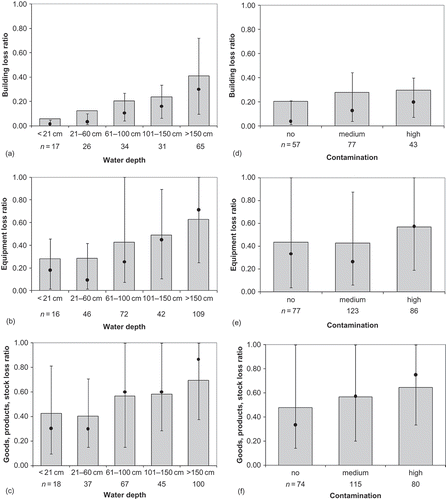
Table 2 Component loadings for variables that probably influence damage of companies (principal component analysis with varimax rotation; total variance explained is 56.7%; number of valid cases is 41)
In the second component, factors concerning the size of the affected company (business volume, number of employees) obtain high loadings. Studies done after the extreme flood in August 2002 in Saxony revealed that larger companies are more likely to undertake precautionary measures and seem to be more efficient at undertaking emergency measures (Kreibich et al., Citation2005, Citation2007). Large companies with more than 100 employees have, on average, 13%, 34% and 36% lower loss ratios for buildings, equipment and goods, products and stock, respectively, in comparison with small companies of up to 10 employees ().
Fig. 2 Resistance factors: loss ratios of buildings ((a), (d), (g)), equipment ((b), (e), (h)) and goods, products and stock ((c), (f), (i)) divided into sectors ((a)–(c)), company size classes in terms of employee number ((d)–(f)) and precaution classes ((g)–(i)). The bars represent the mean, the points and error bars represent the median and 25–75%-percentiles. Loss ratios are significantly different at the 0.05 level for (b), (e), (g), and (h).
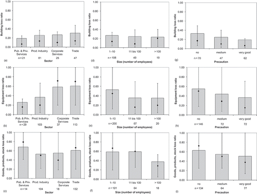
The third component is particularly marked by a high loading of precaution (as well as flood experience and ownership structure). It was shown before, that companies with flood experience and which own their buildings are undertaking precautionary measures more often than others (Kreibich et al., Citation2005, Citation2007). Precautionary measures of flood proofing constructions may achieve a significant damage reduction of 25–100% in trade and industry (ICPR, Citation2002). On average, the companies which had undertaken very good precaution were able to reduce their loss ratios for buildings, equipment and goods, products and stock by 41%, 33% and 19%, respectively (). Flood duration, lead time and sector are the dominating factors in the fourth component, while high loadings for sector, size of premises and contamination mark the fifth ().
It is a common approach in flood-loss modelling to use separate stage–damage curves for the different sectors (e.g. Smith, Citation1981; NR&M, Citation2002; FEMA, Citation2003; Merz et al., Citation2004; Penning-Rowsell et al., Citation2005a,Citationb; Scawthorn et al., Citation2006). Besides, a case study done after the extreme flood in August 2002 in Saxony revealed that, in nearly all phases of flood management, there are significant differences between the sectors (Kreibich et al., Citation2007). However, here only the equipment loss ratios are significantly different between the four distinguished sectors ().
Contamination is an important factor influencing loss ratios. During the extreme flood in August 2002 in Saxony, for example, sewage, chemical and/or oil contamination increased the mean building damage by 18–47% for companies (Kreibich et al., Citation2005). Other studies revealed that oil contamination may lead, on average, to a three times higher building damage, and in particular cases even to total loss (Müller, Citation2000; Egli, Citation2002). The loss ratios of companies which were not affected by additional contamination were, on average, 32%, 23% and 26% lower for buildings, equipment and goods, products and stock, respectively, than the companies which were affected by highly contaminated flood water ().
5 FLEMOcs – LOSS RATIO MODEL ON THE MICRO-SCALE
A loss estimation model should be able to handle different inventories of exposed assets (e.g. a specific insurance portfolio; the total assets of company property in the area of investigation) to be useful for financial appraisal and economic assessment in the framework of cost–benefit analysis for flood defence schemes. Consequently, the new model, FLEMOcs, was composed as a relative model, i.e. the model first calculates loss ratios and, in a second step, the loss ratios are multiplied by the monetary (replacement or depreciated) value of the exposed assets.
Since the uncertainty in damage estimation is decreasing, the more independent damage influencing factors are included in loss models (Büchele et al., 2004; Merz et al., Citation2004), the multi-factorial FLEMOcs model considers four additional factors besides the water level. The model was developed analogous to FLEMOps – Flood Loss Estimation MOdel for the private sector (Thieken et al., Citation2008). Factor selection is based on the results of various studies (e.g. Gissing & Blong, Citation2004; Kreibich et al., Citation2005, Citation2007, Citation2009; Penning-Rowsell et al., Citation2005a,Citationb), as well as on the loss data analysis. The two impact factors – water depth and contamination – were selected as determining factors for the model, together with three resistance factors – indicator for precaution, size of the company (number of employees) and sector. Each selected factor shows its highest loading in a different component of the undertaken PCA ().
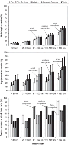
The model structure was adapted from FLEMOps, a loss model for residential buildings and contents, that had proved to be efficient and accurate (Kreibich & Thieken, Citation2008; Thieken et al., Citation2008). The FLEMOcs flood-loss model was designed to work in two stages as a rule-based model. The first stage takes into consideration: the water depth, divided into five classes (<21 cm, 21–60 cm, 61–100 cm, 101–150 cm, >150 cm); three sizes of company with respect to the number of employees (1–10, 11–100, >100 employees); and four different economic sectors (public and private services, producing industry, corporate services, trade) (). Due to lack of adequate data it was not possible to calculate the mean loss ratios of all possible combinations of these three parameters. Therefore, the loss data of all 642 interviewed companies were divided into separate sub-samples according to the water depth classes and the company sectors and sizes ( and ). The mean loss ratios of the water depth sub-samples were taken as the basis. Additionally, scaling factors resulting from the differences between sector and size sub-samples, irrespective of the water level, were calculated. The results of this first model stage are then calculated by multiplying the mean loss ratios of the water depth sub-samples by the scaling factors. This first model stage results in estimated loss ratios for buildings, equipment and goods, products and stock, for all possible combinations of input parameter ().
Fig. 3 First stage of the micro-scale FLEMOcs model: mean loss ratios of flood losses to: buildings, equipment, and goods, products and stock, depending on water depth, sector and size of the company.
In an optional second stage, the different possible combinations of contamination and precaution can be taken into consideration, if the necessary information is available. The estimated loss ratios of the first stage are multiplied by the respective scaling factors (), which have been calculated by comparison of the respective sub-samples of the loss data ( and ). Unfortunately, a differentiation between the water depth classes, the sectors and sizes of companies was not possible for the development of the scaling factors, due to a lack of data. If this multiplication with the scaling factors leads to impossible loss ratios of over 100%, the estimates are set to 100%, i.e. total loss. The second model stage is referred to as FLEMOcs+. The concept of scaling or adjustment factors for flood-damage curves was already developed by McBean et al. (Citation1988), who calculated adjustment factors for flood warning, long-duration floods and floods with high velocities or ice. Accordingly, the situation concerning the water depth, size and sector, as well as contamination and precaution, if possible, has to be known for each flood-affected company, so that its probable loss ratio can be calculated. For instance, for a small company with up to ten employees in the trade sector, which is affected by a water depth of up to 20 cm, a loss ratio for equipment of 41% is estimated via the first stage of FLEMOcs (). In the second stage (FLEMOcs+), this result may be modified as follows: the occurrence of high contamination without any precautionary measures would increase this ratio by 33% (); no contamination and good precaution would reduce this result by 28% ().
Table 3 Scaling factors for the second stage of the micro-scale FLEMOcs model (FLEMOcs+) for company losses of: buildings, equipment, and goods, products and stock, depending on contamination and precaution
6 Estimation of the companY assets
For the estimation of absolute losses, it is necessary to combine the relative loss ratios of the model with data on the asset values of a company. Therefore, an asset value database for the whole of Germany was created, combining macro-economic data from the Federal Statistical Office Germany and the Federal Employment Agency with geo-marketing data (www.destatis.de; INFAS GEOdaten, Citation2001). In this newly created database (Seifert et al., Citation2010b), locations and types of production sites, as well as the kind of assets and their monetary value, are recorded.
As an estimator of the monetary value, the stock of fixed assets was used (data from the Federal Statistical Agency). Whether the gross or the net stock of fixed assets should be used in loss model application must be decided from case to case, e.g. for recalculation of occurred flood losses, the gross stock of fixed assets is more suitable, because it reflects better the repair costs. Within the stock of fixed assets, the asset types “building” and “machinery, equipment and immaterial assets” were distinguished and are thus consistent with the loss functions of FLEMOcs. As for the asset type “goods and products”, no up-to-date statistical data were available. Therefore, its asset values for different sectors were derived as a fraction of the asset values for “machinery, equipment and immaterial assets”. The fractions were calculated from the same empirical data (i.e. surveys among flood-affected companies following the floods in 2002, 2005 and 2006), which were used for the development of FLEMOcs.
The main calculation steps are shown in . The first step “reclassification of economic activities” was necessary, because the geo-marketing data followed a different classification of economic activities than the other data sets. Therefore, reclassification was carried out according to the German classification system WZ 2003, which is based on the NACE system (Eurostat, Citation2002). In the second step, the original input on the stock of fixed assets had to be modified to avoid counting asset values that did not belong to industrial or commercial assets (e.g. private households). Also, assets which cannot be affected by a flood (e.g. intellectual property) were omitted.
Fig. 4 Procedure for the calculation of an asset values database for commercial and industrial assets.
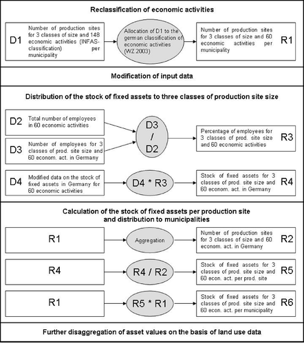
As an analysis of the data on the stock of fixed assets showed that there was a large variability between the asset values of different economic activities, in the third step, the stock of fixed assets was allocated among 60 economic activities and three classes of production site size. In order to be consistent with FLEMOcs, the three sizes of production site were also defined by the number of employees (1–10, 11–100, >100). In the following step, the asset values were disaggregated to the municipality level using the number of production sites in every municipality. For further details of the asset estimation method, see Seifert et al. (Citation2010b). For a combined application of the asset database with FLEMOcs, the 60 economic activities of the database were further aggregated to the same four business sectors that are distinguished in the loss model. Finally, the asset values were spatially disaggregated on the basis of land-use data (see Section 7).
7 SPATIAL Disaggregation of Asset Values
For regional flood risk assessment, meso-scale loss models based on land-use categories (i.e. data which are available countrywide) are advantageous. For loss modelling and risk analysis, the provision of exposure data at the municipal level is not sufficient. Therefore, the municipal asset estimates have to be further disaggregated on the basis of realistic assumptions and dasymetric mapping techniques. Most approaches use land cover information as ancillary data (e.g. Eicher & Brewer, Citation2001; Thieken et al., Citation2006), or data on the road network (e.g. Chen et al., Citation2004).
CORINE land cover data (CLC2000; DLR-DFD & UBA, Citation2000) and the mapping technique of Mennis (Citation2003) were adapted for the disaggregation of the company assets. The CLC2000 data set gives a European-wide overview of land use in 44 categories, as of the year 2000 (Mohaupt-Jahr & Keil, Citation2004). After reclassification into six main classes: settlement areas (LU1), industrial areas (LU2), arable land (LU3), meadows (LU5), forests (LU6), and others such as water areas, open-pit mines or rocks (LU99), the CLC2000 data are intersected with the boundaries of municipalities provided by INFAS Geodaten (Citation2001) with the help of the GIS ArcView 3.2. Then each polygon within a municipality is given a specific weight that determines the share of the asset values that is assigned to this polygon.
According to Mennis (Citation2003), the weights are composed of two factors: a building density fraction and an area ratio. The building density fraction describes how many buildings are (or how much building area is), on average, located in a specific land cover class. This fraction was determined per economic sector. The functions/uses of all buildings from the ATKIS data set of the federal states of Mecklenburg-Western Pomerania and Saxony-Anhalt (BKG, Citation2004) were grouped into the four sectors of the loss model plus the residential and agricultural sector. Unfortunately, this detailed ATKIS information is only available for these two federal states in Germany. Thus, the resulting average building density fractions based on the analysis of these federal states are taken as German average values. Then the areas of the buildings were intersected with the reclassified CLC2000 data.
shows the resulting generalized building density fractions, assuming no buildings in land cover class LU99. Around 60% of the buildings in the sectors trade, corporate, as well as private and public services are located in the settlement areas of the CLC2000 data set. A considerable part of the buildings (14–34%) is also located in areas that are classified as arable land. This is particularly due to villages and settlements that are smaller than 25 ha and that are thus not mapped in the CLC2000 data set as settlement areas. Buildings of the industry in particular are also situated in areas classified as industrial or commercial sites ().
Table 4 Percentages of areas of buildings per land cover type and business sector based on the analysis of detailed ATKIS data from Mecklenburg-Western Pomerania and Saxony-Anhalt (building density fractions)
The building density fractions cannot be used directly for dasymetric mapping since the percentages of the land cover classes in each municipality differ from the overall distribution of the land cover classes. Therefore, too high assets might be assigned to small areas. For this reason an area ratio was introduced by Mennis (Citation2003). It is determined by the percentage of a polygon area within a municipality as well as a correction factor that reflects the global distribution of the land cover classes in the total data set, i.e.:
The asset values (see Section 6) can be disaggregated by multiplying the municipal asset value per sector by the respective total fractions, fijk . Unit asset values in €/m⊃ are achieved for the reference year of the asset database by dividing the disaggregated value by the polygon's area. For applications to other years, the asset values have to be corrected by applicable price indices. The resulting data set can be easily converted into a raster and then used in loss modelling. The result are the asset values per square metre for four business sectors, three sizes of production site and three types of assets on a raster basis.
8 CONCLUSIONS
The new FLEMOcs model for the estimation of flood losses in the commercial sector considers, in the first model stage, the water depth due to flood, divided into five classes, three sizes of company in terms of the number of employees, and four different sectors. In the second model stage, the effects of precaution level and degree of contamination can also be evaluated. The model can be applied to the micro-scale, i.e. to single production sites, as well as to the meso-scale, i.e. land-use units, which enables its countrywide application. The development of a disaggregated asset database for the commercial sector was presented. Due to the usage of relative loss functions it is possible to consider a dynamic input of asset databases. Therefore, the model can be used for various applications, e.g. insurance purposes and flood management tasks. Further research will be aimed at inserting uncertainty at the micro-scale, which could be done by accounting for the variation of loss ratios in each factor class. The model is available for scientific use via a web service on the internet platform NaDiNe (http://nadine.helmholtz-eos.de/FLEMO.html).
Acknowledgements
This research was funded by the German Ministry of Education and Research (BMBF) within the framework of the project MEDIS – Methods for the Evaluation of Direct and Indirect Flood Losses (no. 0330688). Provision of data by the Deutsche Rückversicherung is gratefully acknowledged. The questionnaire (in German) of the 2006 survey is available at www.gfz-potsdam.de/portal/gfz/Struktur/Departments/Department+5/sec54/Ressourcen/Dokumente/Questions +gfl06?binary=true&status=300&language=de(accessed 17 September 2010).
Related Research Data
REFERENCES
- Al-Futaisi , A. and Stedinger , J. R. 1999 . Hydrologic and economic uncertainties and flood-risk project design . J. Water Resour. Plan Manage , 125 ( 6 ) : 314 – 324 .
- BKG . 2004 . Digital Landscape Model ATKIS Basis-DLM. Vermessungsverwaltungen der Länder und BKG, Lieferung Juni 2004 , Frankfurt am Main : BKG . Bundesamt für Kartographie und Geodäsie
- Büchele , B. , Kreibich , H. , Kron , A. , Thieken , A. H. , Ihringer , J. , Oberle , P. , Merz , B. and Nestmann , F. 2006 . Flood-risk mapping: contributions towards an enhanced assessment of extreme events and associated risks . NHESS , 6 : 485 – 503 .
- Chen , K. , McAneney , J. , Blong , R. , Leigh , R. , Hunter , L. and Magill , C. 2004 . Defining area at risk and its effect in catastrophe loss estimation: a dasymetric mapping approach . Appl. Geogr. , 24 : 97 – 117 .
- DLR – DFD(German Aerospace Centre – German Remote Sensing Data Centre) & UBA (The Federal Environment Agency) . 2000 . CORINE Land Cover 2000. Daten zur Bodenbedeckung — Deutschland (Data on land cover — Germany) , Berlin : DLR – DFD . Oberpfaffenhofen
- Egli , T. 2002 . “ Hochwasserkatastrophe Ostdeutschland 2002 – Erkenntnisse in Bezug auf Gebäudeschäden. Bericht über die Aufklärungsmission der Direktion für Entwicklung und Zusammenarbeit ” . In (DEZA Abt. Humanitäre Hilfe und Schweizer Katastrophenhilfekorps) im Katastrophengebiet des Hochwassers der Elbe und ihrer Seitenflüsse vom 23–30 August 2002 , Report (in German) : St. Gallen: Vereinigung Kantonaler Feuerversicherungen .
- Eicher , C. L. and Brewer , C. A. 2001 . Dasymetric mapping and areal interpolation: implementation and evaluation . Cartogr. Geogr. Inf Sci. , 28 ( 2 ) : 125 – 138 .
- Emschergenossenschaft & Hydrotec . 2004 . Hochwasser-Aktionsplan Emscher, Kapitel 1: Methodik der Schadensermittlung , Essen : Emschergenossenschaft . Report
- Eurostat (2002) Statistical Classification of Economic Activities in the European Community, NACE Rev.1.1. http://europa.eu.int/comm/eurostat/ramon/ (http://europa.eu.int/comm/eurostat/ramon/) (Accessed: 1 February 2006 ).
- FEMA . 2003 . HAZUS-MH Technical Manual , Washington, DC : FEMA, Department of Homeland . Federal Emergency Management AgencyTechnical Report
- Ganoulis , J. 2003 . Risk-based floodplain management: a case study from Greece . Int J River Basin Manage , 1 ( 1 ) : 41 – 47 .
- Gissing , A. and Blong , R. 2004 . Accounting for variability in commercial flood damage estimation . Aust Geogr , 35 ( 2 ) : 209 – 222 .
- Green , C. 2003 . “ Handbook of Water Economics: Principles and Practice ” . In Hoboken , NJ : John Wiley & Sons, Inc .
- ICPR . 2001 . Übersichtskarten der Überschwemmungsgefährdung und der möglichen Vermögensschäden am Rhein , Koblenz : ICPR . International Commission for the Protection of the River Rhine
- ICPR . 2002 . Non Structural Flood Plain Management – Measures and their Effectiveness , Koblenz : ICPR . International Commission for the Protection of the River Rhine
- INFAS Geodaten (2001) Das Data Wherehouse. Bonn, INFAS GEOdaten GmbH. http://www.infas-geodaten.de (http://www.infas-geodaten.de)
- Kaiser , H. F. 1960 . The application of electronic computers to factor analysis . Edu. Psychol. Meas. , 20 : 141 – 151 .
- Kreibich , H. , Müller , M. , Thieken , A. H. , Petrow , T. and Merz , B. 2007 . Flood precaution of companies and their ability to cope with the flood in August 2002 in Saxony , 004691 Germany : Water Resour . Res. 43, W03408. doi:10.1029/2005WR
- Kreibich , H. , Piroth , K. , Seifert , I. , Maiwald , H. , Kunert , U. , Schwarz , J. , Merz , B. and Thieken , A. H. 2009 . Is flow velocity a significant parameter in flood damage modelling? . NHESS , 9 : 1679 – 1692 .
- Kreibich , H. and Thieken , A. H. 2008 . Assessment of damage caused by high groundwater inundation . Water Resour , Res. 44, W09409. doi:10.1029/2007WR006621
- Kreibich , H. , Thieken , A. H. , Müller , M. and Merz , B. 2005 . “ Precautionary measures reduce flood losses of households and companies – insights from the 2002 flood in Saxony, Germany ” . In : Floods, from Defence to Management , Edited by: van Alphen , J. , van Beek , E. and Taal , M. 851 – 859 . London : Taylor & Francis Group .
- Kron , A.. 2007 . “ Flood damage estimation and flood risk mapping ” . In Advances in Urban Flood Management , Edited by: Ashley , R. , Garvin , S. , Pasche , E. , Vassipoulos , A. and Zevenbergen , C. 213 – 235 . London : Taylor & Francis .
- LfUG . 2005 . “ Hochwasser in Sachsen ” . In Gefahrenhinweiskarten , Dresden : Sächsisches Landesamt für Umwelt und Geologie . Landesamt für Umwelt und GeologieReport
- MURL (Ministerium für Umwelt, Raumordnung und Landwirtschaft des Landes Nordrhein-Westfalen) . 2000 . Potentielle Hochwasserschäden am Rhein in NRW , Düsseldorf : MURL Report .
- McBean , E. A. , Gorrie , J. , Fortin , M. , Ding , J. and Moulton , R. 1988 . Adjustment factors for flood damage curves . J. Water Resour. Plan Manage , 114 ( 6 ) : 635 – 646 .
- Mennis , J. 2003 . Generating surface models of population using dasymetric mapping . Prof Geogr , 55 ( 1 ) : 31 – 42 .
- Merz , B. , Kreibich , H. , Thieken , A. H. and Schmidtke , R. 2004 . Estimation uncertainty of direct monetary flood damage to buildings . NHESS , 4 : 153 – 163 .
- Merz , B. and Thieken , A. H. 2004 . Flood risk analysis: concepts and challenges . Oesterr. Wasser Abfallwirtschaft , 56 ( 3–4 ) : 27 – 34 .
- Messner , F. and Meyer , V. 2005 . Flood damage, vulnerability and risk perception – challenges for flood damage research , Leipzig : UFZ . UFZ discussion paper 13/2005
- Mileti , D. S. 1999 . Disasters by Design. A Reassessment of Natural Hazards in the United States , Washington, DC : Joseph Henry Press .
- Mohaupt-Jahr , B. and Keil , M. 2004 . “ The CLC 2000 project in Germany and environmental applications of land use information ” . In CORINE Land Cover 2000 in Germany and Europe and its use for Environmental Applications, Workshop, 20–21 January 2000 , Berlin : Umweltbundesamt (Federal Environmental Agency) .
- Müller , M. 2000 . Die Auswirkungen von Deichbrüchen und Heizöllagerung auf Überschwemmungsschäden bei Wohngebäuden (in German) . Versicherungswirtschaft , 151 ( 10 ) : 693 – 696 .
- NR&M . 2002 . Guidance on the Assessment of Tangible Flood Damages , Queensland, Australia : NR&M Report . Department of Natural Resources and Mines, Queensland Government
- NRE . 2000 . Rapid Appraisal Method (RAM) for Floodplain Management Report prepared by Read Sturgess and Associates Melbourne, Australia Department of Natural Resources and Environment, Victoria
- Norušis , M. J. 2002 . SPSS 11.0 Guide to Data Analysis , Upper Saddle River, NJ : Prentice Hall .
- Olsen , J. R. , Beling , P. A. , Lambert , J. H. and Haimes , Y. Y. 1998 . Input–output economic evaluation of system of levees . J Water Res. , 124 ( 5 ) : 237 – 245 .
- Penning-Rowsell , E. and Chatterton , J. B. 1977 . The Benefits of Flood Alleviation: A Manual of Assessment Techniques , Aldershot : Gower Technical Press .
- Penning-Rowsell , E. , Johnson , C. , Tunstall , S. , Tapsell , S. , Morris , J. , Chatterton , J. and Green , C. 2005a . The Benefits of Flood and Coastal Risk Management: A Handbook of Assessment Techniques , London : Middlesex University Press .
- Penning-Rowsell , E. , Johnson , C. , Tunstall , S. , Tapsell , S. , Morris , J. , Chatterton , J. and Green , C. 2005b . The Benefits of Flood and Coastal Risk Management: A Manual of Assessment Techniques , London : Middlesex University Press .
- Scawthorn , C. , Flores , P. , Blais , N. , Seligson , H. , Tate , E. , Chang , S. , Mifflin , E. , Thomas , W. , Murphy , J. , Jones , C. and Lawrence , M. 2006 . HAZUS-MH flood loss estimation methodology. II. Damage and loss assessment . Nat Hazards Rev. , 7 ( 2 ) : 72 – 81 .
- Seifert , I. , Kreibich , H. , Merz , B. and Thieken , A. H. 2010a . Application and validation of FLEMOcs – a flood-loss estimation model for the commercial sector . Hydrol. Sci. J. , 55 ( 8 ) 1315–1324
- Seifert , I. , Thieken , A. H. , Merz , M. , Borst , D and Werner , U . 2010b . Estimation of industrial and commercial asset values for hazard risk assessment . Nat. Hazards , 52 ( 2 ) : 453 – 479 .
- Smith , D. I. 1981 . Actual and potential flood damage: a case study for urban Lismore, NSW, Australia . Appl. Geogr. , 1 : 31 – 39 .
- Smith , K. and Ward , R. 1998 . Floods: Physical Processes and Human Impact , Chichester : John Wiley & Sons, Ltd .
- Takeuchi , K. 2001 . Increasing vulnerability to extreme floods and societal needs of hydrological forecasting . Hydrol. Sci J. , 46 ( 6 ) : 869 – 881 .
- Thieken , A. H. , Müller , M. , Kleist , L. , Seifert , I. , Borst , D. and Werner , U. 2006 . Regionalisation of asset values for risk analyses . NHESS. , 6 ( 2 ) : 167 – 178 .
- Thieken , A. H. , Müller , M. , Kreibich , H. and B , Merz . 2005 . Flood damage and influencing factors: new insights from the August 2002 flood in Germany . Water Resour. Res. , 41 ( 12 ) : W12430 004177 doi:10.1029/2005WR
- Thieken , A. H. , Olschewski , A. , Kreibich , H. , Kobsch , S. and Merz , B. 2008 . “ Development and evaluation of FLEMOps – a new Flood Loss Estimation MOdel for the private sector ” . In Flood Recovery, Innovation and Response , Edited by: Proverbs , D. , Brebbia , C. A. and Penning-Rowsell , E. 315 – 324 . Chichester : WIT Press .