Abstract
Hydrologists responsible for flood management need real-time data in order to manage imminent or ongoing floods. In this paper, innovative methods for accessing hydrological data and their spatial visualization are introduced. A multitude of relevant real-time, forecast and historical information is provided in a single, self-updating hydrological map information system. The system consists of a central database and a cartographic user interface and provides harmonized and filtered data in the form of interactive, customizable maps. Maps may also be cross-referenced with historical maps or may be animated for improved comprehension and decision making. Emphasis is placed on the development of the hydrological real-time database that manages large amounts of spatial, temporal and attributive data. The paper focuses on the cartographic user interface, its functionality and the resulting interactive hydrological maps.
Citation Lienert, C., Weingartner, R. & Hurni, L. (2011) An interactive, web-based, real-time hydrological map information system. Hydrol. Sci. J. 56(1), 1–16
Résumé
Les hydrologues responsables de la gestion des crues ont besoin de données en temps réel afin de gérer des crues imminentes ou en cours. Cet article introduit des méthodes innovantes concernant l'accès aux données hydrologiques et leur visualisation. Une multitude de données en temps réel, prévues et historiques est mise à disposition dans un système d'information cartographique hydrologique unifié et mis à jour automatiquement. Le système consiste en une base de données centrale et une interface utilisateur cartographique, et offre des données harmonisées et filtrées sous la forme de cartes interactives et personnalisables. Les cartes peuvent également être recoupées avec des cartes historiques, ou peuvent être animées pour améliorer la compréhension et la prise de décision. L'effort est mis sur le développement de la base de données hydrologiques en temps réel qui gère de grandes quantités de données spatiales, temporelles et attributaires. L'article insiste sur l'interface utilisateur cartographique, ses fonctionnalités, et les cartes hydrologiques interactives qui en résultent.
1 INTRODUCTION
1.1 Overview
The integration of real-time data in interactive cartographic visualization has gained little attention in research to date, although the need for such integration workflows has been postulated (Openshaw et al., Citation2000; Laurini et al., Citation2001).
In hydrology and related environmental domains, visual real-time applications assist in handling the huge and ever-growing quantities of data generated by automatic gauges and remote sensing devices. Such applications also have the potential to support flood management and forecasting tasks. Hydrologists advising crisis management groups, the potential stakeholders of such systems, have a practice-oriented background and are pressed for time. Additional to direct monitoring data in the form of tables and diagrams, their decisions can greatly benefit from filtered and classified real-time information in the form of interactive maps. There are different reasons why real-time maps built on well-structured hydrological data are valuable in flood management. They generally allow for better readability and easier comprehension. More specifically, flood risk areas can be identified and examined much more quickly. Also, better analytical assistance and more objective assessment of a given hydrological situation are provided. In addition, maps that visualize model outputs make modelling more accessible to users who may not have in-depth knowledge of modelling techniques. Likewise, dynamic real-time maps may help in gaining new insights into flood processes (Jamieson, Citation1996; Cutter, Citation2003).
This paper introduces novel methods for the development of a web-based, real-time map information system. While efforts in flood management primarily concentrate on hydrometeorological forecasting, a complementary strategy is pursued with this system, emphasising novel data access and spatial visualization methods for hydrologists. Forecast data, as well as real-time and historical observations, are handled automatically and jointly. This greatly facilitates integrated assessment, classification and documentation of flood events during occurrence. In the system presented here, data are used which cover the entire area of Switzerland.
The paper is structured as follows: the introduction summarizes the main motivation for the information system and the aims of the project, which is based on a survey of user needs, followed by a review of previous research and related literature in the second section. The next three sections describe the methodology. First, the design of the system is presented: considerations are made concerning temporal data modelling, system components and workflows between components triggered by the specific system use. Special emphasis is placed on the conceptual distinction between the hydrological database and the cartographic user interface. The second methodology section contains a description of the hydrological database with emphasis on real-time aspects. This database is the core of the presented map information system. Its purpose is to manage temporal, attributive and spatial data of hydrological variables in a combined way. This specific database structure is decisive for data linking, finally allowing conversion into cartographic visualizations. The third methodological section is on the cartographic user interface and covers the conceptual design and implementation of the web-based map interface, with maps serving as the central media for data access and visualization. Paramount importance is attached to the visual quality of the maps, the usability of the interface and the high degree of user interactivity. The paper closes with a discussion of the main results and conclusions are drawn on the overall map information system.
1.2 Motivation
Two main aspects motivated the development of the presented information system. First, we aimed to alleviate the current situation with the increasing potential for floods to damage infrastructures. In recent decades, vulnerability and susceptibility of infrastructures to floods have greatly increased. Due to population growth, increased mobility and more expensive infrastructures, the damage potential in flood-prone areas has increased (e.g. Petrascheck & Kienholz, Citation2003; Beniston, Citation2007). In parallel, an increased frequency and intensity of extreme flooding and rainfall is being identified in various parts of the world (e.g. Dettinger & Diaz, Citation2000; Schmidli & Frei, Citation2005). Climate models taking into account different future climate scenarios indicate that existing trends will intensify even more and flood risks will increase (e.g. Labat et al., Citation2004; KOHS, Citation2007).
The second motivation is to meet the needs of users better in order to facilitate decision making in critical situations. Semi-structured interviews and workshops were held with administrative-level flood experts to assess the expectations of potential users. The following statements were collected from the participants:
| a. | Concerning the state-of-the art:
| ||||||||||||||||||||||||||||
| b. | Concerning the requirements of the map information system, there is a need for:
| ||||||||||||||||||||||||||||
The interviews and workshops made clear that, at least in Switzerland, three main deficiencies in flood management exist: first, key indicators, such as streamflow observation at specific (upstream) river sections or precipitation forecast data for specific parts of a basin, are stored on different analogous and digital media, causing data compilation to become a time-consuming task. Automatic data collection is needed in order to increase the lead times of flood peaks and to plan interventions prior to event peaks.
Second, the key variables that need to be available in real time must include: streamflow (flood peak, time of hydrograph rise); precipitation (spatial distribution, volume, intensity, duration); groundwater (level); air temperature (distribution, 0°C line); snow (depth, water equivalent); and indicator data for soil moisture. These key variables were deemed suitable since they allow one to infer instantaneous, antecedent, as well as interrelated hydrological information.
Third, field specialists are experienced in assessing a critical situation primarily on the basis of a few hydro-meteorological gauging sites in the basin. Processed, spatially referenced data, presented in high-quality maps, will facilitate better comprehension, and spatial overviews in cases of flooding, by all responsible parties in flood management.
2 RELATED WORK
2.1 Related applications
For various reasons, existing hydrological information systems very often fail to meet the needs of flood experts. Some contain maps and diagrams generated using data that have been averaged over a certain time period, such as analogous and digital hydrological atlases and related visualization systems (Spreafico & Weingartner, Citation1992–2010; Fuhrmann, Citation2000). These visualizations fully comply with cartographic standards, but, since hydrological atlases are not intended to support real-time flood management, real-time data are not involved in the map production. Other systems include a wealth of high-value, real-time and forecast data, but the information is not primarily visualized in maps, but rather in graphs and diagrams (e.g. Zappa et al., Citation2008; Jia et al., Citation2009). Again, other systems use maps as the primary interface to data, but visualizations and interactivity are limited to a small number of parameters, describing streamflow and groundwater conditions only (e.g. Soh et al., Citation2006); thus, not all identified key parameters are integrated. Other systems focus on the historical description of events and do not include spatial data (Black & Law, Citation2004), or on real-time hydrographs, tables and charts (e.g. Cheng et al., Citation2004). There are also systems handling hydrological data for purposes other than flood warning, such as evaluation of policy measures or land-use changes (e.g. Engel et al., Citation2003; de Kort & Booij, Citation2007).
However, to summarize, at least one of the following characteristics is missing in each of these applications. As a consequence, our goal is to incorporate each of these characteristics in the system presented here:
| • | availability of real-time and historical data | ||||
| • | spatial referencing and visualization of data in maps | ||||
| • | high cartographic quality (e.g. map layout, readability, colour design) | ||||
| • | interactive methods to adapt map content and layout | ||||
| • | integration of multiple flood-relevant variables | ||||
2.2 Trends in related fields
Currently, information technology widely affects watershed and flood management, for example, in terms of exchanging and distributing information (Ryan et al., Citation2004). The simplification of data measurement and transmission through upgrading hydro-meteorological measuring devices is the key prerequisite for our map information system. Also, the increased quality of weather forecasting data and its implications on flood hydrology is of particular interest. Of equal interest are the trends in data processing brought about by hydrological information systems and spatial data sharing in the form of visualizations through the Internet that have been carried over to our system. In and the following sub-sections, a chronological overview of the changes and current methods in these four fields is shown.
Fig. 1 Current methods in hydro-meteorological network technology, forecasting, hydrological information system architecture and data visualization. In the dashed rectangle, the proposed real-time map information system is indicated (HY. INF. = hydrological information).
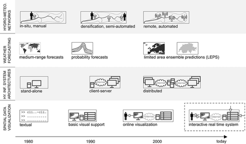
2.2.1 Upgrade of hydro-meteorological networks
The automation and real-time operation of hydro-meteorological observation networks is a necessity for improved flood management and other operational research programs (e.g. Doraiswamy et al., Citation2000). In situ collection is complemented, or entirely replaced, by automated gauges that measure and transmit data over radio or telephone systems. Although the installation and maintenance of these automatic networks requires a lot of resources, data processing is efficiently simplified and costs decline as the technology continues to evolve.
Our real-time hydrological map information system needs to process and display these increasing data amounts fully automatically and in an error-free manner. Both the database and the cartographic user interface need automatic, continuous updating mechanisms so that the most actual information is available to the user by default.
2.2.2 Weather forecasting
In weather forecasting, the current state-of-the art is to combine several forecast series and deduce probabilistic information on predicted changes (Lynch, Citation2008). Ensemble prediction systems (EPS) have become the guide for many operational weather service centres. Limited-area ensemble prediction systems (LEPS), which are EPS for smaller spatial domains, have evolved for short-term forecasting. Currently, this concept is transferred to hydrological modelling. The propagation of uncertainty from the meteorological predictions to hydrological models allows for more differentiated assessments in early warning situations (e.g. Cloke & Pappenberger, Citation2009).
Our map information system therefore should be able not only to consider deterministic outputs of hydrological or meteorological models, but also to take into account the associated ensembles. In the maps and the graphics, both the deterministic and the stochastic values have to be made available, e.g. by plotting confidence intervals together with the deterministic streamflow forecasts.
2.2.3 System architectures of hydrological information systems
Over the years, a shift from stand-alone hydrological model systems towards integrated and distributed architectures could be observed (Al-Sabhan et al., Citation2003). Databases and hydrological models are run on a server and results are distributed over the Internet to various desktop computers (Longley et al., Citation2005; Holz et al., Citation2006). Complex computations in environmental modelling, including hydrology, are outsourced to several servers where data are processed in a step-wise manner. In such distributed technical environments, users may control modelling processes via geo-portals where maps are, however, only a side product of analysis procedures. Thereby, source data are processed and results are passed as basic parameters to the other servers before being returned to users' desktop computers over the Internet (Horak et al., Citation2008; Granell et al., Citation2010). Despite some technical limitations (see below), the role of the Internet to disseminate, exchange and communicate information is widely recognized as a means to reduce adverse effects of floods and other natural hazards (Anderson, Citation2003).
In our map information system, interactive maps act as a central device to communicate with the database. Users do not have to deal with underlying models or processing steps, but merely use the fully cartographically processed output of the system.
2.2.4 Spatial data visualization
Spatial data visualization used to be rudimentary, and visual support was introduced primarily for data quality control purposes (Longley et al., Citation2005). Owing to the advantageous topological–thematic structure of geographic information system (GIS) databases, maps are increasingly produced on the basis of such spatial databases (Hurni, Citation2008). Current web-maps are provided in web browsers on desktop computers. The visualizations are prepared server-side, often directly from databases and are disseminated to users' computers in web-compatible image formats. Using the computer's mouse and keyboard, interaction with the database and remote programmes takes place via the web-map (Peterson, Citation2008).
The next consequential step for our map information system, shown in the dashed rectangle in , is to acquire, manage and visualize real-time data automatically. Interaction with the real-time database, as previously mentioned, has to take place by means of a cartographic user interface. It should be noted, however, that the map display within the interface depends on network bandwidths. During an emergency, system services are requested by a potentially large number of users. Busy or interrupted networks may result in a poorly performing interface and erroneous map rendering. This situation is continuously improving with the increase of Internet bandwidth. Another viable solution is to perform the complex modelling server-side, and to visualize data client-side (Bo & Michael, Citation2001).
3 DESIGN OF THE MAP INFORMATION SYSTEM
Taking the statements made by flood experts into consideration, a system needs an integrated modular base to perform the following functions: (a) render vast amounts of temporal, spatial and attributive data manageable; (b) harmonize and structure data from various sources; (c) combine data over selected regions and time periods; (d) make data easily accessible to users; and (e) extend the system with further real-time data. In this section, a system design that meets these needs is presented and specific considerations on temporal data modelling are made.
3.1 System design
The system design is shown as a conceptual scheme in . The scheme consists of three main blocks: data sources, database and user interfaces. The data sources comprise real-time observation, hydrological model and weather forecast data, data from gauges and radar, as well as pre-processed data (including historical time series, statistical data, static geographical data and metadata). The database is split into six main partitions which comprise real-time, forecast and historical data (temporal partitions), static geographical data (spatial partition), and statistical data as well as metadata (attributive partitions).
Fig. 2 Conceptual scheme of the real-time map information system. Continuous arrows denote manual database manipulation options provided by user interfaces. Dashed arrows denote automatic real-time data insertions and updates.
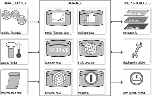
Three user interfaces to the database are available: the first, and most important, is the cartographic user interface. It is incorporated in the web browser and provides interactive web-based data access to all database partitions and returns (carto-)graphic visualizations. The second is a set-up and extension interface for adept (administrator) users to initialize the overall spatio-temporal database and to extend it with new real-time measurement networks. The third user interface aims to facilitate the import of pre-processed data and the export of data from any of the six database partitions (e.g. time series or some metadata) in the form of text files.
Conceptually, the cartographic user interface is further divided into three data analysis and visualization modes: monitoring, retracing and comparing (Lienert et al., Citation2009). Monitoring aims to answer the question “what is currently going on?” in the basin, making use of overview maps and interactive map elements. Retracing seeks to answer “how have events emerged?” over the last few hours and days, offering animated map views. The question “when and how have other/similar events occurred?” is covered by the comparing mode. The underlying idea of this third mode is to make the knowledge of the past available through easily retrievable historical maps. Analysing the decisions made on the basis of similar historic events may facilitate current decision making (Llasat et al., Citation2005; Brázdil et al., Citation2006).
3.2 The notion and modelling of time
From a hydrological viewpoint, the notion of time is greatly influenced by the spatial scale to which hydrological processes are temporally related (Blöschl & Grayson, Citation2001). A map information system handling real-time data may work technically in basins of any size. But, expected countermeasures are effective only in hydrological basins which have runoff response times in the range of hours. In a small basin, smaller time steps are required than in larger ones. Furthermore, effective countermeasures in small basins can only be taken when a very reliable short-term meteorological forecast is available, most notably from weather radar (Germann et al., Citation2009).
From the point of view of data modelling, the notion of time involves the consideration of a valid time and a transaction time. Real time means that events are stored at the same time as they occur. More specifically, the time during which a fact is true in reality (valid time) is synchronous with the time a fact is stored as a data record in the database (transaction time). This is not always perfectly true in our system, due to a small time gap of 5–30 min in the updating process. In such cases, transaction time is later than valid time and our system is only close to real time. Storing projections of future states, e.g. delivered by meteorological or hydrological forecasts, implies that valid time occurs later than transaction time (Ott & Swiaczny, Citation2001).
From another point of view on data modelling, temporal data have to be differentiated into various time instances, such as: (a) the time when data are measured; (b) the time when data are delivered; (c) the time when the database system is updated; and (d) the time when users access the system. However, including time in a database-driven information system does not require entirely new data models. Rather, existing models need to be augmented in order to support more effective temporal indexing and analysis. In our case, ideally, time is modelled as an attribute of entities that have unchanging spatial properties (Ott & Swiaczny, Citation2001; Hoel, Citation2008). In other words, time may be handled as columns in those database tables which represent static gauging locations.
4 HYDROLOGICAL DATABASE
A database can be thought of as an integrated set of data on a particular subject. There are several database models, including the most widely used (object-)relational. Data sets are stored in files which are only accessed by database management systems (DBMS) that organize efficient and effective storage and access to data (Longley et al., Citation2005). In order to manage huge amounts of high-resolution data and to perform concurrent operations (e.g. inserting, updating, filtering, sorting, linking, aggregating), an object-relational database system is deployed, along with a spatial extension to include spatial geometry data.
In this section, the available real-time data networks and the basic data and their harmonization are addressed. The database scheme, its implementation and query examples are discussed subsequently.
4.1 Overview and assessment of basic time series data
The basic real-time data consist of data supplied by various Swiss administrative offices that operate hydrological, meteorological and snow observation networks, covering the entire country (see Spreafico & Weingartner, Citation1992–2010, plates 2.12, 3.12 and 5.12). In parallel, an extensive archive of high-resolution temporal data was compiled for the module comparing, which are thematically identical to those collected in real time. Archive data were recorded at 10-min intervals and go back to the 1970s.
shows an overview of the real-time data collection. Efforts were made to collect all the data parameters that were favoured in the prior workshops. Complementing hydrological data with meteorological, groundwater and snow information allows the bigger picture to be assessed more coherently. Only a few existing real-time parameters are not (yet) included in the system: the snow line and the snow water equivalent.
Table 1 Overview of available real-time variables
The spatial density of data sources is considerable, as data from more than 500 individual ground gauges were processed. From the hydrological viewpoint, however, mainly due to the complex topography of Switzerland, some measuring arrangements have deficiencies. For example, the number of automatic precipitation ground gauges is limited at high altitudes and is still too small to sufficiently capture the nation-wide precipitation situation. Also, the three existing radar stations do not entirely capture smaller inner-alpine precipitation cells. Both the ground gauge network and the radar network are being extended for these reasons.
The data quality of real-time data is generally very high. Faulty data are infrequently delivered and gauge failures are usually remedied quickly. Yet, all of the real-time data are provisional and accounted as such by the network operator. Historical time series data, in turn, are checked annually and are therefore of very high quality. Historical meteorological data were additionally homogenized where needed. Some data gaps do exist in the historical snow depth time series.
The availability of forecast data is deemed reliable. Forecast models are operated on separate servers and their operation does not affect the performance of our map information system. Our system directly uses the output of these models. Runoff forecasts are calculated by two different semi-distributed rainfall–runoff models, which are executed in real time. The PREVAH (Precipitation-Runoff-EVapotranspiration Hydrological response unit) and the FEWS/HBV (Flood Early Warning System/Hydrologiska Byrns Vattenbalansavdelningels) model of the Swiss Federal Office for the Environment are coupled with meteorological forecasts (Zappa et al., Citation2008; Viviroli et al., Citation2009). The outputs of these models are handled in the system like virtual real-time gauges.
4.2 Data harmonization and pre-processing: how to deal with imperfect data
By inserting supplier-specific data into one single database, a consistent, coherent and uniform base is created for further processing, analysis and cartographic visualization. Periodically executed programme routines fetch data files on various distributed remote servers of data suppliers, check their creation time, convert data into data records and insert them into our central database. This automated data flow is illustrated in by the dashed arrows.
In contrast, data harmonization involving data semantics requires rule-based solutions beforehand. These rules are based on the plausibility of the data and are deduced from descriptive statistics of the hydrological data material. summarizes the levels on which semantic problems may arise and presents suggested solutions.
Table 2 Semantic data problems on different processing levels and suggested real-time solutions
| a. | On the acquisition level, plausibility and validity checks are important, but modifications should be kept to a minimum. For example, as streamflow data cannot be negative, checking the algebraic sign, or converting supplier-specific void values into the data type required by the database, is adequate at acquisition time. Other conditions might be verified and additional data could be directly calculated, such as the adherence to data delivery intervals. | ||||
| b. | On the database level, semantic problems may be solved by database-internal functions. Data integrity or data duplicate conflicts are best solved by functions provided by the DBMS that work with constraints that disallow insertion of irregular data. | ||||
| c. | On the visualization level, problems of faulty, outlier and missing data are solved with cartographic symbols in order to leave the real-time database undistorted. This is assured since maps are created spontaneously in the cartographic user interface—after data have been retrieved from the database. Specific symbolization for missing data or representing uncertainty margins in time series graphs may be applied in case of faulty or outlier data. When data are missing, either no data are retrieved or the most recent available data in the database may be retrieved and visualized. | ||||
4.3 Implementation scheme, data linking and data queries
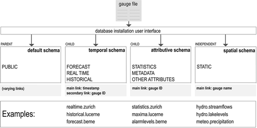
To initialize the empty database, the database installation user interface (see also ) is employed in combination with text-based gauge files. Data providers keep overviews of their measurement networks in such files, which usually contain the complete list of gauge names, identification number (gauge ID) and geographical coordinates. As shown in , the conversion of gauge files results in an inheritable organization of temporal and attributive data. The majority of data are stored in two child database schemas (i.e. “folders”). To ensure their easy modification, they are directly linked to parent tables. Parent tables act like mirrors and the changes and manipulations made on them automatically take effect on the child tables. Operations such as data insertion and updates are greatly facilitated by this parent–child approach. The much smaller amount of spatial data does not require such a superior tool. Spatial data are therefore held independent from parent tables.
Fig. 3 Database implementation scheme. The gauge file is a text-based overview of gauges provided by network operators.
Users may wish to access data in the system either by their spatial, temporal and attributive properties, or by just choosing individual hydrological variables. These four data aspects are modelled and implemented in the system, so that all possible interrelations are retrievable, depending on the users' needs. One might be interested in several hydrological variables at a certain time, or in several time states of one single variable within a given spatial section, with reference to another spatial section. Or users may want to retrieve the recurrence intervals of variables in a given basin during a specific historical flood event. Aggregated historical information (e.g. precipitation sums, long-term streamflow maxima) might be also required to classify actual or forecast data. Yet, in order to visualize these different hydrological data combinations on maps—and also in order to improve overall query speed—time, space and attributive data for each variable are held separately in the database. The relationships between all the records in the database must therefore be modelled explicitly, by either a main or a secondary link. No matter which of the four aspects (time, space, attribute and variable) is retrieved first, any other of the three aspects has to be linked and visualized instantly.
In addition to the overall database implementation scheme, the linking concept and some examples are shown in . Names of tables in the temporal and attributive schemas are gauge names, which are just the main links in the tables of the spatial schema. In other words, spatial tables in the static schema have columns containing these table names. As illustrated by the example, the table “streamflow” in the schema “hydro” contains a record “zurich”, in which spatial reference data and the table name “zurich” are stored. The table name is used both in the attributive and temporal schemas to retrieve the respective data for “zurich”. The use of the equal table names in different schemas greatly facilitates the query process, since linking between attributive and temporal data tables just requires the gauge ID, provided in the initial gauge file. Statistical data, such as flood recurrence intervals, can be used to classify real-time streamflow data immediately; or forecast precipitation amounts at one or more gauge locations might be combined with existing precipitation alarm levels. Querying and linking of data tables in other schemas is accomplished likewise.
For the purpose of sorting, filtering, classifying and aggregating temporal data in an efficient way, time itself was chosen as the main link for temporal data. In each temporal data table, one column named “Time of measurement”, stores time stamps of the measurement and issuance times of observations and forecasts. Technically, a unique constraint is applied on the “Time of measurement” column. It ensures that no measurements made by the same gauge have an identical “Time of measurement” so that data duplicates are avoided. This way, database updating can take place at very short intervals. The same concept applies to radar images, which are physically stored as images on the server. However, their “Time of measurement” and the file paths to their physical location are stored in the database.
During the course of database queries, the result sets are provided with a spatial reference in a coordinate system. This is done either by the DBMS or through auxiliary, external files. In order to present data at an appropriate generalization level in the cartographic user interface (discussed in the next section), database queries have to be adjusted dynamically. Depending on the map scale, data are either added or filtered so that overcharging or cluttering of the map is avoided. Also, during the course of database queries, vector line data may be generalized by simplifying the line geometry.
5 THE CARTOGRAPHIC USER INTERFACE
Using additional visualization functions in the real-time workflow, raster data may be smoothed, and point data may pass through areal interpolation and colouring. After any of these work steps between database retrieval and visualization, intermediate data are automatically converted into graphic formats so that they can be presented in the web-based cartographic user interface.
In this section, the features of this cartographic interface are discussed. The resulting hydrological visualizations are addressed in terms of the three-tiered concept of monitoring, comparing and retracing. Within any of these modes, additional visualizations are available in an auxiliary window.
5.1 Features of the interface and interactive methods
The cartographic user interface consists of four main components: (a) map manipulation tools to create various types of representations; (b) an auxiliary window allowing the display of additional graphical data; (c) a cartographic navigation panel; and (d) a status bar indicating the map mode and whether the map is completely loaded.
In the maps provided by the cartographic user interface, great importance is attached to interactivity. Users should be able to compile map contents and modify map symbols according to their in-situ questions. Spatial navigation controls such as map zooming, panning and re-centring are available. Temporal navigation is provided by selecting time marks that use drop-down lists. Other interactive methods, such as time sliders or clickable calendars, have been proposed for temporal navigation (e.g. Aigner et al., Citation2007). Due to time constraints, these have not yet been implemented in the current version of our system.
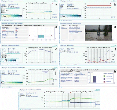
The maps contain interactive symbols. On rolling over or clicking on symbols, additional items are displayed in an auxiliary window (see examples in and ). They include small information boxes (tool tips), listings of attributes, time series graphs and linked legends. Since nearly all map symbols have interactive functionality, map labelling was not deemed necessary.
Fig. 6 Map example for temporal comparing of historical streamflow, lake levels, 20-day precipitation sums, air pressure, groundwater levels and precipitation radar. The map shows the situation of 8 August 2007.
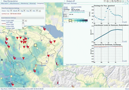
Fig. 7 Nine real-time data visualization examples in the auxiliary window.
5.2 Real-time monitoring
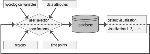
The intention of the following map and graphic examples is to show how hydrological practitioners may extract and combine data according to their needs and requirements, and what additional values are generated with this hydrological information when it is provided in a processed, combined and interactive way (e.g. faster and more comprehensive understanding of flood processes). As shown in the procedure in , the elements to be visualized are first selected by the user, or a default setting is used. Hydrological variables, regions, time points and attributes are chosen on the cartographic user interface, which leads to an extraction from the database. The initial or default visualization may be adapted iteratively, depending on the users' further specifications.
Fig. 4 Interactive map compilation and map viewing procedure.
presents the web-based cartographic user interface, extended by panels for further map manipulation, opening or closing the auxiliary window, map navigation (top) and displaying the current map mode (bottom). At the top left, the monitoring window is activated. Here, users may choose the symbols and colours of the displayed map elements.
Fig. 5 Map example showing real-time monitoring of streamflow, lake levels, 20-day precipitation sums, snow depths, air pressure, forecast runoff and forecast temperature distribution.
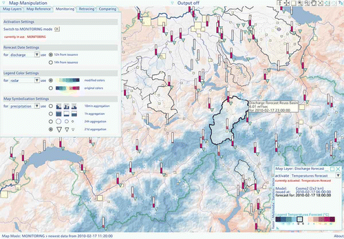
The map fills the entire browser window and other items are placed over it. The map example contains a series of real-time data rendered into different map symbols. The forecast temperatures are displayed as an interpolated surface with the associated legend shown in the auxiliary window (bottom right). Furthermore, the boundaries of selected hydrological basins and sub-basins are also displayed in . One of them is highlighted and presents a tool tip that reveals information on the forecast runoff.
In addition, various geometric and pictographic map symbols are shown. The latter represent snow depths (snowflakes) and groundwater levels (piezometric tubes). Geometric symbols depict air pressure and lake levels (framed rectangles), square symbols denote streamflow, where size stands for absolute quantity and colour for the current value's probability of occurrence; thus, the darker the colour, the longer the recurrence interval (see , example (a), for the legend). Precipitation data are represented by triangles, each representing 20-day precipitation sums. On this aggregation level, precipitation acts as an indicator for soil moisture (Mani et al., Citation2008). Other selectable aggregation levels include 10-min, 1-h and 24-h sums.
The additional value in this example is to see the spatial distribution of the interplay of hydrological factors at different times. Real-time snow depths are contrasted with forecast temperature data, indicating if and where snow is likely to contribute to runoff. Likewise, forecast runoff is displayed with the indicative soil moisture. Additionally, lake levels are shown in order to assess if their retention effect is becoming important. In a critical situation, if some lakes had to be sluiced, real-time streamflow data downstream of lake outlets would help to see if this is practicable.
5.3 Comparing the current situation with the past
In , the cartographic user interface is shown in comparing mode. It displays a map showing the situation on 8 August 2007 around midnight. To add value in the system, drawing on comparable, historical data must be user-friendly. To find and retrieve historical maps, users activate the comparing tab of the map manipulation window at the top left. They may select one of 11 predefined, major flood events, or choose an individual date of interest and load the associated map. Within the cartographic user interface, the historical and current maps may be compared either in parallel, i.e. next to each other, or successively, i.e. one after the other. It is not yet possible to compare the current and the historical situation directly in one single map.
The background of the map in consists of the precipitation radar image and the delineation of hydrological basins. As in the map in , the 20-day precipitation sum triangles, streamflow squares, lake level rectangles and groundwater symbols are shown. The different symbol sizes, proportions and colours clearly indicate the difference between the historical situation in and the current situation in . Additionally, the auxiliary window is activated that contains three time-series graphs. The time point of the map corresponds to the values at the centre of the graphs. The streamflow peak, the increase of the groundwater level and any overruns of the lake's flood level are easily comprehensible.
In this example, the additional value is, first, to retrieve historical data for comparison purposes in a very simple way, without having to collect them externally. With the prior data integrated in the existing database and the functionalities provided on the cartographic user interface, interactive historical maps are very easily available. Time-consuming collection and representation of historical data is avoided. With our map information system, users may instantly classify ongoing events in the long-term context, load additional data such as the precipitation radar and—using various time-series graphs—understand their formation and progress in more detail.
5.4 Retracing flood events
Animating maps in combination with time-series graphs allows for improved understanding of the spatio-temporal patterns and dynamics of floods. Animations may also be useful for communication among peers in crisis management groups, and to prepare post-analysis documentation.
In the current version of the system, the retracing concept is not yet available interactively. However, the results of this concept have been simulated in a semi-automated manner. Series of historical maps have been retrieved, sequenced and then published online as movies (http://reticah.ethz.ch/watch.php?v=R01 and http://reticah.ethz.ch/watch.php?v=R02).
The first example shows a situation in March 2008, when northeastern Switzerland was affected by medium-scale floods. Streamflow is represented by a flow map; observations are interpolated between gauges and they are visualized as a proportional band stretching along the river course (Lienert et al., Citation2008). The band, the square symbols of the streamflow gauges and the time-series graphs of three gauges are animated. Situated at the upper (Jonschwil gauge), middle (Halden gauge) and lower (Andelfingen gauge) reaches of the river, the graphs nicely complement the river band and reveal the spatio-temporal shift of the flood wave.
The second example shows what happened in Switzerland and neighbouring countries during the extreme flooding of 21–24 August 2005. The weather situation on these days was characterized by exceptionally large and enduring precipitation fields over the Alps (Bezzola & Hegg, Citation2007). The radar image sequence impressively reflects this stable cloud formation. The animated time-series graph represents the 24-h precipitation sum of an alpine gauge in central Switzerland. Analogous to streamflow, precipitation sums are represented by a quantitative symbol. The larger and darker the circles, the greater the sums and the higher are the recurrence intervals of these sums. The severity of the August 2005 event becomes clearly evident from these animated maps, time-series graphs and legends.
5.5 Additional visualizations in the auxiliary window
When working with the interactive maps, additional visualizations may be displayed in the auxiliary window. Some of the visualization examples have already been shown in the above figures and animations. The window is a helpful instrument to analyse real-time, historical or forecast data in more detail. Up to four items may be viewed simultaneously, displaying the same or different locations. In , a selection of additional examples is shown. From left to right and top to bottom, the visualization examples include the following information:
| a. | legends, attributes and a combination of the 24-h real-time hydrograph of observed and modelled data; | ||||
| b. | legends, attributes and the 6-h real-time series graph of lake levels, along with the flood level (red line); | ||||
| c. | key figures and an interactive box plot of long-term annual maximum streamflow, along with the observed real-time value; | ||||
| d. | real-time web camera image of the gauge; | ||||
| e. | legends, attributes and 24-h real-time series graph of 24-h precipitation sums; | ||||
| f. | attributes and combination of the 48-h real-time series graph of temperature (red dots), 1-h precipitation sums (blue bars) and cumulative curve (blue line); | ||||
| g. | legends, attributes and a combination of 24-h time-series graph of forecast runoff (green dots) and forecast precipitation for the entire basin; | ||||
| h. | key forecast figures and an interactive graphic of forecast saturation level for the entire basin; and | ||||
| i. | attributes and a combination of a 24-h real time-series graph of observation and model data, extended by the 24-h time-series graph of two hydrological forecast models. | ||||
6 DISCUSSION AND CONCLUSIONS
In this paper, the development of a web-based, real-time map information system for hydrological expert users has been presented. The complete real-time cartography workflow, from conversion of raw hydro-meteorological data to the generation of interactive, animated and web-based maps, proved to be feasible. Meanwhile, the system is operable and tests with regional hydrological authorities in Switzerland have been successfully carried out.
From a technical point of view, the separation of data and their presentation by a central hydrological real-time database and a cartographic user interface proved advantageous, since it enables more targeted design, implementation and debugging of either system part. Data integration and harmonization tasks are indispensable for generating visualizations originating from different sources and having various formats and temporal properties. The main conclusions concerning the hydrological database and the cartographic user interface are as follows:
| • | In the real-time hydrological database, spatial, temporal, attribute data and individual hydrological variables are stored separately, but internally linked for fast, combined retrieval. Temporal data are uniquely defined by their time of measurement. Due to its modular set-up, extension and integration of additional data is ensured. The concept may be used for other domains characterized by strong temporal constraints. | ||||
| • | The web-based cartographic user interface pursues three visualization approaches: data can be monitored, compared or retraced. Real-time data are visualized by maps; thus, they are spatially referenced. Until now, the spatial dimension of such data was often neglected and visualizations were mostly limited to graphs and diagrams. A high degree of user interactivity is provided by the interface. Layout and content of maps are modifiable to better meet the users' needs. | ||||
From a hydrological and user viewpoint, the real-time map information system presented is a shared, database-driven platform that makes available relevant hydrological data from decentralized sources. It processes and visualizes data on national, regional and basin levels. The main additional values for hydrologists of the real-time map information system are as follows:
| • | Real-time data can be combined with forecast and historical data in a single system. Specific questions on the similarities with past events, the evolution, the current state and the forecast situation can be answered from the same source. | ||||
| • | The user wields a flexible, interactive tool in which hydrological variables, data attributes, regions and time points are freely selectable. Interactive functionalities are geared towards letting users conduct data analysis and exploration themselves, according to their own expertise. | ||||
| • | Various users at different locations may share the system, according to their individual needs. | ||||
| • | The system is applicable not only to flood management, but also for other hydrological and water resources management questions (e.g. water quality, seasonal forecasting). The high degree of flexibility regarding its applicability is what distinguishes this real-time hydrological map information system. | ||||
Further work steps may include the full integration of map animations (i.e. automatic build, interactive controls) in order to complete the retracing concept. System tests with hydrological users will be continued to further facilitate the use of the cartographic interface. Also, the missing snow data (snow line, water equivalent) have to be included. Further research questions may include the identification and definition of flood patterns to find similar flood events in the database automatically by means of more complex queries. With a structure that allows access to data via values, location, temporal properties and topics, the database is well-suited for this purpose.
Acknowledgements
The support of the Swiss National Science Foundation for this research project (Grant no. 200020-122291) is gratefully acknowledged. The authors also wish to thank two anonymous reviewers for their valuable comments and suggestions.
REFERENCES
- Aigner , W. , Miksch , S. , Müller , W , Schumann , H. and Tominski , C. 2007 . Visualizing time-oriented data -- a systematic view . Computers & Graphics , 31 ( 3 ) : 401 – 409 .
- Al-Sabhan , W. , Mulligan , M. and Blackburn , G. A. 2003 . A real-time hydrological model for flood prediction using GIS and the WWW . Computers, Environment and Urban Systems , 27 ( 1 ) : 9 – 32 .
- Anderson , P. S. 2003 . “ Bringing early warning to the people: electronic technology: the role of the Internet ” . In Early Warning Systems for Natural Disaster Reduction , Edited by: Zschau , J. and Küppers , A. N. 85 – 87 . Berlin : Springer .
- Beniston , M. 2007 . Linking extreme climate events and economic impacts: Examples from the Swiss Alps . Energy Policy , 35 ( 11 ) : 5384 – 5392 .
- Bezzola , G. R. and Hegg , C. 2007 . Ereignisanalyse Hochwasser 2005 – Teil 1 Prozesse, Schäden und erste Einordnungen , Bern and Birmensdorf : Swiss Federal Office for the Environment, FOEN, and Swiss Federal Institute for Forest, Snow and Landscape Research, WSL .
- Black , A. R. and Law , F. M. 2004 . Development and utilization of a national web-based chronology of hydrological events . Hydrol. Sci. J. , 49 ( 2 ) : 237 – 246 .
- Blöschl , G. and Grayson , R. 2001 . “ Spatial observations and interpolation ” . In Spatial Patterns in Catchment Hydrology – Observations and Modelling , Edited by: Grayson , R. and Blöschl , G. 17 – 50 . Cambridge : Cambridge University Press .
- Bo , H. and Michael , W. 2001 . Dynamic modelling and visualization on the Internet . Trans. GIS , 5 ( 2 ) : 131 – 139 .
- Brázdil , R. , Kundzewicz , Z. W. and Benito , G. 2006 . Historical hydrology for studying flood risk in Europe . Hydrol. Sci. J. , 51 ( 5 ) : 739 – 764 .
- Cheng , C.-T. , Chau , K. W. , Li , X.-Y. and Li , G. 2004 . Developing a Web-based flood forecasting system for reservoirs with J2EE . Hydrol. Sci. J. , 49 ( 6 ) : 973 – 986 .
- Cloke , H. L. and Pappenberger , F. 2009 . Ensemble flood forecasting: a review . J. Hydrol. , 375 ( 3-4 ) : 613 – 626 .
- Cutter , S. L. 2003 . GI Science, disasters and emergency management . Trans. GIS , 7 ( 4 ) : 439 – 446 .
- de Kort , I. A. T. and Booij , M. J. 2007 . Decision making under uncertainty in a decision support system for the Red River . Environ. Model. Software , 22 ( 2 ) : 128 – 136 .
- Dettinger , M. D. and Diaz , H. F. 2000 . Global characteristics of stream flow seasonality and variability . J. Hydromet. , 1 ( 4 ) : 289 – 310 .
- Doraiswamy , P. C. , Pasteris , P. A. , Jones , K. C. , Motha , R. P. and Nejedlik , P. 2000 . Techniques for methods of collection, database management and distribution of agrometeorological data . Agric. For. Met. , 103 ( 1-2 ) : 83 – 97 .
- Engel , B. A. , Choi , J.-Y. , Harbor , J. and Pandey , S. 2003 . Web-based DSS for hydrologic impact evaluation of small watershed land use changes . Computers and Electronics in Agriculture , 39 ( 3 ) : 241 – 249 .
- Fuhrmann , S. 2000 . Designing a visualization system for hydrological data . Comput. Geosci. , 26 ( 1 ) : 11 – 19 .
- Germann , U. , Berenguer , M. , Sempere-Torres , D. and Zappa , M. 2009 . REAL – Ensemble radar precipitation estimation for hydrology in a mountainous region . Quart. J. Roy. Met. Soc. , 135 ( 639 ) : 445 – 456 .
- Granell , C. , Daz , L. and Gould , M. 2010 . Service-oriented applications for environmental models: reusable geospatial services . Environ. Model. Software , 25 ( 2 ) : 182 – 198 .
- Hoel , E. 2008 . “ Data models in commercial GIS systems ” . In Encyclopedia of GIS , Edited by: Shekar , S. and Xiong , H. 215 – 219 . Berlin : Springer .
- Holz , K.-P. , Hildebrandt , G. and Weber , L. 2006 . Concept for a web-based information system for flood management . Natural Hazards , 38 : 121 – 140 .
- Horak , J. , Orlik , A. and Stromsky , J. 2008 . Web services for distributed and interoperable hydro-information systems . Hydrol. Earth System Sci. , 12 ( 2 ) : 635 – 644 .
- Hurni , L. 2008 . “ Multimedia atlas systems ” . In Encyclopedia of GIS , Edited by: Shekar , S. and Xiong , H. 759 – 763 . Berlin : Springer .
- Jamieson , D. G. 1996 . Preface . J. Hydrol. , 177 ( 3-4 ) : 161 – 162 .
- Jia , Y. , Zhao , H. , Niu , C. , Jiang , Y. , Gan , H. , Xing , Z. , Zhao , X. and Zhao , Z. 2009 . A WebGIS-based system for rainfall–runoff prediction and real-time water resources assessment for Beijing . Comput. Geosci. , 35 ( 7 ) : 1517 – 1528 .
- HS , KO . 2007 . Impact of climate change on flood protection in Switzerland – a position paper of the Commission on Flood Protection of the Swiss Association for Water Management (KOHS) . Wasser Energie Luft , 1 : 55 – 57 .
- Labat , D. , Goddéris , Y , Probst , J. L. and Guyot , J. L. 2004 . Evidence for global runoff increase related to climate warming . Adv. Water Resour. , 27 ( 6 ) : 631 – 642 .
- Laurini , R. , Servigne , S. and Tanzi , T. 2001 . A primer on TeleGeoProcessing and TeleGeoMonitoring . Computers, Environment and Urban Systems , 25 ( 3 ) : 249 – 265 .
- Lienert , C. , Schnabel , O. , Hutzler , E. and Hurni , L. A real-time flow map of the Swiss 1:200 000 river network. Considerations on its preparation and its dynamic integration into a web-based prototype . Proc. Sixth ICA Workshop on Mountain Cartography . February 11–15 2008 , Lenk, Switzerland. International Cartrographic Association, Commission on Mountain Cartography .
- Lienert , C. , Weingartner , R. and Hurni , L. 2009 . Real-time visualization in operational hydrology through web-based cartography . Cartogr. Geogr. Inf. Sci. , 36 ( 1 ) : 45 – 58 .
- Llasat , M.-C. , Barriendos , M. , Barrera , A. and Rigo , T. 2005 . Floods in Catalonia (NE Spain) since the 14th century. Climatological and meteorological aspects from historical documentary sources and old instrumental records . J. Hydrol. , 313 ( 1-2 ) : 32 – 47 .
- Longley , P. A. , Goodchild , M. F. , Maguire , D. J. and Rhind , D. W. 2005 . Geographical Information Systems and Science , Chichester : John Wiley & Sons .
- Lynch , P. 2008 . The origins of computer weather prediction and climate modeling . J. Comput. Phys. , 227 ( 7 ) : 3431 – 3444 .
- Mani , P. , Schmocker , P. , Bollaert , E. and Anres , M. 2008 . “ An early warning system for the Thunersee – Hydro-meteolorogical indicators for the operation of the culvert in Thun ” . In Proc. 11th Interpraevent Congress (Dornbirn, Austria) , Klagenfurt, , Austria : International Research Society, INTERPRAEVENT .
- Openshaw , S. , Fischer , M. , Benwell , G. and MacMillan , B. 2000 . “ GeoComputation research agendas and futures ” . In Geocomputation , Edited by: Openshaw , S. 379 – 400 . London : Taylor & Francis .
- Ott , T. and Swiaczny , F. 2001 . Time-integrative Geographic Information Systems Management and Analysis of Spatio-temporal Data , Berlin : Springer .
- Peterson , M. 2008 . “ An introduction ” . In International Perspectives on Maps and the Internet , Edited by: Peterson , M. 3 – 10 . Heidelberg: Springer .
- Petrascheck , A. and Kienholz , H. 2003 . “ Hazard assessment and mapping of mountain risks in Switzerland ” . In Debris-flow Hazards Mitigation: Mechanics, Prediction and Assessment , Edited by: Rickenmann , D. and Chen , C.-L. 25 – 38 . Rotterdam: Millpress .
- Ryan , C. M. , Guertin , D. P. and Philip , H. 2004 . Information technology in watershed management decision making . J. Am. Water Resour. Assoc. , 40 ( 2 ) : 347 – 357 .
- Schmidli , J. and Frei , C. 2005 . Trends of heavy precipitation and wet and dry spells in Switzerland during the 20th century . Int. J. Climatol. , 25 ( 6 ) : 753 – 771 .
- Soh , L.-K. , Zhang , J. and Samal , A. 2006 . A task-based approach to user interface design for a web-based hydrologic information systems . Trans. GIS , 10 ( 3 ) : 417 – 449 .
- Spreafico , M. and Weingartner , R. 1992–2010 . Hydrological Atlas of Switzerland HADES , Berne : Swiss Federal Office for the Environment .
- Viviroli , D. , Zappa , M. , Gurtz , J. and Weingartner , R. 2009 . An introduction to the hydrological modelling system PREVAH and its pre- and post-processing-tools . Environ. Modelling & Software , 24 ( 10 ) : 1209 – 1222 .
- Zappa , M. , Rotach , M. W. , Arpagaus , M. , Dorninger , M. , Hegg , C. , Montani , A. , Ranzi , R. , Ament , F. , Germann , U. , Grossi , G. , Jaun , S. , Rossa , A. , Vogt , S. , Walser , A. , Wehrhan , J. and Wunram , C. 2008 . MAP D-PHASE: real-time demonstration of hydrological ensemble prediction systems . Atm. Sci. Lett. , 9 ( 2 ) : 80 – 87 .
APPENDIX
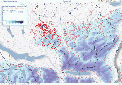
Two additional map examples for real-time monitoring are appended. The real-time map in shows the interpolated snow depths in combination with the 0°C isotherm. This information allows the assessment of the contribution of snowmelt to runoff. Streamflow is depicted by arrow symbols, which indicate whether the actual value is greater than, equal to or smaller than the previous one.
Fig. A1 Map example showing real-time monitoring of snow depth distribution, 0°C-isotherms, lake levels, groundwater levels, air humidity, 24-h precipitation sums and streamflow (as arrows; see text for explanation).
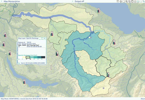
In , on top of a hypsometric background map, real-time streamflow is represented in three different ways: (1) as square point symbols; (2) as a flow map along the river course; and (3) as specific discharge where streamflow is related to the basin area upstream. The latter, in particular, allows for a quick areal overview. Additionally, air humidity, air pressure and air temperature are represented by framed rectangle symbols.
Fig. A2 Map example showing real-time monitoring of streamflow (depicted by squares), by an interpolated band along the river course and by specific discharge areas (L s-1 km-2) for selected hydrological sub-basins. Air humidity, air temperature and air pressure are shown as framed rectangles.