Abstract
This paper presents a viable approach for flood management strategy in a river basin based on the European Floods Directive. A reliable flood management plan has two components: (a) a proper flood management strategy, and (b) the determination of the flood-hazard areas. A method to evaluate the benefits of a flood warning system is presented herein, as well as a method to estimate the flood-hazard areas. Six factors were considered in order to estimate the spatial distribution of the hazardous areas: flow accumulation, slope, land use, rainfall intensity, geology and elevation. The study area was divided into five regions characterized by different degrees of flood hazard ranging from very low to very high. The produced map of flood-hazard areas identifies the areas and settlements at high risk of flooding. The proposed methodology can be applied to any river basin and here was applied to the Koiliaris River basin in Greece.
Citation Kourgialas, N. N. & Karatzas, G. P. (2011) Flood management and a GIS modelling method to assess flood-hazard areas—a case study. Hydrol. Sci. J. 56(2), 212–225.
Résumé
Cet article présente une approche viable pour établir la stratégie de gestion des inondations dans un bassin versant, basée sur la Directive Européenne relative aux Inondations. Un plan de gestion des inondations fiable a deux composantes: (a) une stratégie appropriée de gestion des inondations, et (b) la détermination des zones soumises à l'aléa inondation. Une méthode pour évaluer les avantages d'un système d'alerte en cas d'inondation est présentée, ainsi qu'une méthode pour estimer les zones d'aléa. Six facteurs ont été pris en compte pour estimer la répartition spatiale des zones d'aléa: l'accumulation d’écoulement, la pente, l'occupation du sol, l'intensité pluviométrique, la géologie et l'altitude. La zone d’étude a été divisée en cinq régions caractérisées par différents degrés d'aléa inondation, allant de très faible à très élevé. La carte des zones d'aléa inondation produite identifie les zones et les établissements à haut risque. La méthodologie proposée peut être appliquée à n'importe quel bassin versant et a ici été appliquée au bassin du Fleuve Koiliaris en Grèce.
1 Introduction
The number of flood events has increased significantly all around the world over the last three decades. While the number of fatalities per flood event exhibited an almost constant trend during the 1980s and 1990s, it has markedly decreased since the year 2000 despite the significant increase in the number of floods (Parker et al., Citation2007). The main causes of changes in flood risk are climatic changes, changes in land use and other anthropogenic interventions. The most common anthropogenic effects are: urban growth, the partial or total cover of torrent banks, watercourse alignment, improperly dimensioned bridges, deforestation and the consequent erosion, the construction of roads or other structures across the watercourse, subsidence observed in flat regions due to anthropogenic interventions such as overpumping, and, finally, the change or deviation of the watercourse (Green et al., Citation2000).
It is important to note that total flood prevention is not feasible, while the evaluation and management of future floods can be carried out. This paper presents a plan for a viable flood preparedness which consists of two main interlinked components: (a) a proper flood management strategy; and (b) the determination of the hazardous areas in the region of interest. Indeed, the second component is an inherent part of the flood management strategy. However, the distinction is very helpful since the emphasis here is on the estimation of areas of high flood hazard.
1.1 Flood management strategy
The flood management strategy includes: (i) pre-flood measures, (ii) flood forecasting, and (iii) post-flood measures.
Pre-flood measures provide the natural, institutional and social infrastructure for the viable management of a flood risk. Strategies for preventive flood management include: technical measures to control and manage the flood (small dams and projects on the retention and stabilization of river banks); regulating measures for land use and the planning of settlements; and economic measures for the regulation, promotion and communication (Water Directors, Citation2003).
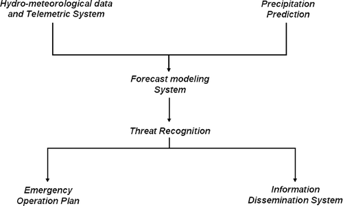
The Flood Forecasting-Warning System (FFWS) includes the planning of a network of telemetric stations for recording rainfall, meteorological parameters and river flow. This system can also provide a direct warning system for the development of an evacuation plan (Green et al., Citation2000). As shown in , a FFWS has six components, and is used to increase flood warning time, reduce damage and save lives. A well-designed FFWS needs a hydrometeorological data acquisition and transmission system that allows the real-time storage of rainfall, water level and discharge data at a central station (Ford, Citation2001). Threat recognition based only on the observed rainfall and water-level data cannot be considered adequate for flood warning purposes in watersheds characterized by short hydrological response time. Therefore, it is necessary that the FFWS include a forecast modelling system capable of predicting flows and stages from the measurements provided by the hydrometeorological data acquisition and transmission system along with the physiographic features of the watershed.
Fig. 1 Components of a flood forecasting-warning system (FFWS).
Typically, the more realistic the modelling of the key hydrological processes, the more accurate the forecast will be. After the forecast model has been calibrated, it can be employed to estimate the basin response to any rainfall event (Barbetta et al., Citation2006). It is important to mention that the type of the forecasting model used will depend on the river basin characteristics. In particular, it should be emphasized that, as far as the conceptual approaches are concerned, the model choice depends on the catchment properties. For large rivers, with drainage areas of 104 km2 and above, models based only on flood wave routing can be used for flood-prone sites located downstream of a gauged station providing discharge data and at a distance allowing an appropriate forecasting lead time (O'Connell & Clarke, Citation1981; Franchini & Lamberti, Citation1994; Lamberti & Pilati, Citation1996; Moramarco et al., Citation2006). Moreover, for medium-sized catchments (102–103 km2), rainfall–runoff models of semi-distributed type seem to be more reliable for operational activities, provided that an updating procedure can be adopted (Michaud & Sorooshian, Citation1994; Boyle et al., Citation2001). However, the uncertainty degree in representing the rainfall–runoff transformation together with the need for available accurate rainfall data have led researchers to investigate also the potential of flood routing approaches for this type of catchment in order to obtain short-term forecasts. When the selected river reach is characterized by a negligible intermediate drainage area, flood routing models without lateral inflow representation can be used.
Post-flood measures promote the fast re-establishment of the affected regions and include measures of alleviation, re-establishment of the damaged infrastructure, and the revision of the effectiveness of the flood-prevention system. Local authorities that have adopted a programme of readiness and a plan for mitigating the consequences can respond much more effectively in the case of a flood (Wright & Monday, Citation1996). Recently, the Hazards US Multi-Hazard (HAZUS-MH) flood model, a natural hazards loss-estimation software, was developed in order to quantify the human, property, financial and social impacts of flooding under existing conditions and given possible mitigation measures (relocation, land-use planning, structural modifications and warning). Based on the HAZUS-MH software, the beneficial impacts of these mitigation measures can be analysed, permitting informed decision making (Scawthorn et al., Citation2006).
1.2 Flood vulnerability and flood-hazard areas
According to Adger (Citation2006), vulnerability is usually portrayed in negative terms as the susceptibility to being harmed. It is driven by inadvertent or deliberate human action that reinforces self-interest and the distribution of power, in addition to interacting with physical and ecological systems (Adger, Citation2006). Flood vulnerability is defined as the degree of susceptibility to damage from hazardous, water-related phenomena (Gallopin, Citation2006). In order to determine flood vulnerability, it is important to identify the sources of danger of a sudden river flood and to locate the highly hazardous areas. The classical approach for the delineation of flood-prone areas with different hazard levels is based on the application of hydrological-hydraulic modelling. However, for ungauged basins, and in areas where expensive and time-consuming hydrological-hydraulic simulations are not possible, the use of an effective tool to delineate the flood-prone areas is essential (Manfreda et al., Citation2008). Moreover, the identification of areas at high risk of flooding is very important in small hydrological basins where the flood warning time is short.
The synthesis of data and the mapping of the relationships between natural hazard phenomena and the elements at risk require the use of tools such as geographic information systems (GIS). Natural hazards are multi-dimensional phenomena which have a spatial component; thus, the GIS is very well suited in such applications (Zerger, Citation2002). The GIS has evolved in three broad application domains: the first is the use of the GIS as an information database; the second is its use as an analytical tool, a means of specifying logical and mathematical relationships among layers of maps to yield new derivative maps; and the third is its use as a decision support system. To meet a specific objective in a decision support system, several criteria need to be evaluated by means of procedures referred to as “multi-criteria evaluation” or simply “modelling”. The integration of multi-criteria analysis (MCA) with a grid-based GIS in order to analyse flood vulnerable areas provides more flexible and accurate decisions (Eastman et al., Citation1995).
The weights in multi-criteria analysis are assigned to prioritize the relative importance of the different criteria. A major problem in MCA is that the weights are subjected to the judgment of the decision maker (Yeh et al., Citation1999). There is a large number of methods available to determine the weights. The fundamental problems affecting the MCA process are the determination of the weights and ensuring that they are credible (RPA, Citation2005). So, one of the main purposes of this study was to face that challenge. Two of the most common procedures for multi-criteria evaluation are weighted linear combination and concordance–discordance analysis (Carver, Citation1991). In the former, each factor is multiplied by a weight and then summed to arrive at a final suitability index, while in the latter, each pair of alternatives is analysed for the degree to which one outranks the other on the specified criteria. Concordance–discordance analysis is computationally impractical when a large number of options is present (such as with raster data where every pixel is an option). However, the weighted linear combination is very straightforward in a raster GIS (Eastman et al., Citation1995).
In this work, a flood management strategy is proposed for the Koiliaris River basin in Chania, Crete, Greece. Furthermore, this study identifies the flood-hazard areas in this basin.
2 FLOOD MANAGEMENT STRATEGY FOR THE KOILIARIS RIVER BASIN
2.1 General characteristics of the Koiliaris River basin
The Koiliaris River basin, where flood phenomena appear from time to time, is located 15 km east of the city of Chania, Crete, Greece (). The basin extends from the White Mountains (Lefka Ori) to the coastline.
Fig. 2 The hydro-meteorological network in the Koiliaris River basin and a representation of the elevations-zones of the technical measures.
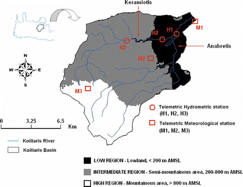
The area of the basin is estimated to be 130 km2, while the total length of the hydrological network of the Koiliaris River is 36 km. The length of the river from the intersection point where all the streams meet to the outflow point is 3.3 km. The elevation of the basin ranges from zero to 2120 m a.m.s.l. The topography of the area of interest is smooth with a mild topographic slope of 12%. The geology of the basin is mainly carbonate (karst), Quaternary-Neogenic deposits and flysch formations. Karst is defined as a terrain, generally underlain by limestone, in which topography is mainly formed by the dissolution of rock, and is characterized by sinkholes, drainage and caves. The karst regions affect significantly the generation of flash floods (Bonacci et al., Citation2006). Based on a former research project conducted by the Ministry of Agriculture of Greece (Citation2000), 58% of the total land use of the basin is characterized as pasture (public or private), 29.4% as crops, 2.8% as settlements and roads, 8.5% as forests, 0.6% as water surfaces and 0.7% as other uses.
The Koiliaris River basin is characterized by extreme flood events of low frequency but high magnitude. The geomorphological characteristics of the basin contribute to the generation of many flash floods and karstic flash floods (Kourgialas & Karatzas, Citation2009). The Koiliaris River has two main tributaries, the Keramiotis and the Anabretis rivers (). The flow from the Keramiotis tributary is responsible for the generation of high, flash-flood peaks downstream along the Koiliaris River. There are three telemetric hydrometric stations (H1, H2, H3) and three telemetric meteorological stations (M1, M2, M3) in the basin (). These stations provide hourly real-time data which are used to determine hydrological and meteorological parameters. The flood hydrographs are very sharp, with steep rises and short lag times at all hydrometric stations. The response time of the basin to an intense rainfall event is a few hours. Moreover, when the cross-section of the hydrometric station H1 is completely covered with water, the hydraulic depth is equal to 3.4 m and the flooding flow (Q max) is 92.6 m3/s.
During the last 50 years many extreme floods have occurred in the basin, especially in the downstream area. According to historical data, the most extreme events took place on 26 October 1968, 11 January 1978, 7 December 2000, 4 November 2001 and 12 February 2003. All these extreme floods caused significant damage to properties and constructions.
2.2 The flood management strategy
2.2.1 Pre-flood measures
Technical measures
A flood-preventing protection plan should start from the mountainous regions in order to moderate the phenomenon in its generation. Based on the European Floods Directive (CEC, Citation2007) and the Water Framework Directive (CEC, Citation2000), the elevations of the river basin were divided into three management zones: (a) the low region (<200 m); (b) the intermediate region (200–800 m); and (c) the high region (>800 m) (). Concerning the Koiliaris River basin, the following measures are proposed for the different elevation areas.
In the high regions, where a sudden increase of torrent kinetic energy may appear, the flood phenomenon has not yet begun. This is where the main volume of water is collected before it proceeds to the low regions. Technical measures, such as tanks and inhibitory dams, can be constructed for the interception of the flood. Such measures can assist with the time desynchronization of the water accumulation at points where the kinetic energy of the torrent is increased, and, consequently, can decrease the rate of the kinetic energy release. This can be achieved only if the technical measures are well-designed and strategically located considering the basin hydrology. In addition, protection measures from deforestation and fires should be considered, since they play an important role in the prevention of flood phenomena.
In the intermediate regions, which are defined between the high regions and the low dangerous regions, the issue is complex due to the high flow kinetic energy caused by the significant difference in elevation. The technical intervention in such cases is rather difficult due to the morphology of the torrents and their high kinetic energy. However, in the case of the Koiliaris River basin, a large area is defined as karst; therefore, the possibility of artificial groundwater enrichment can be investigated. Geological conditions play an important role in these regions and a detailed knowledge is essential (Green et al., Citation2000).
In the low regions, few actions can be carried out for intercepting the phenomenon, such as the protection of banks from erosion and cleaning the watercourse from deposits. Many rock walls have been installed along the banks of the river where floods have taken place in the past. These regions are mainly suitable for institutional and managerial interventions that ensure the natural operation of the flood plain and protect vulnerable areas from human activities (structure building, industrial and agricultural activities, etc.).
Regulatory, economic and communication measures
Based on the size of the Koiliaris River basin and the specific characteristics of the area, local authorities can incorporate innovations and policies at relatively low cost. The pilot application of an innovative programme adopted by a given local authority will cost much less, in the case of failure, than if the same programme had been applied nationwide. However, in case of success, the pilot application could be considered as “best practice” and be expanded nationwide (Bouwen et al., Citation2004).
The small size of the municipalities allows flexibility that is fundamental for effective flood management. Over the years, local authorities can develop relationships with the citizens and express the particularities and peculiarities of each region (Pahl-Wostl, Citation2006).
In particular, the local authorities should: (a) delineate the flood-hazard areas; (b) seek the acquisition of property in high-risk regions and the relocation of the residents of such regions; (c) establish or strengthen the existing legislation and the planning of secure land use in order to regulate the growth in these regions; (d) create economic incentives; (e) publicize the information regarding flood risk; (f) provide training to emergency services so that they are in readiness in case of a flood; (g) ensure that the medical care services are in readiness during a flood event; and (h) improve the readiness of the local society by strengthening not only the contact, but also the attendance of the national programmes related to natural destruction management.
2.2.2 Flood warning system (FWS)
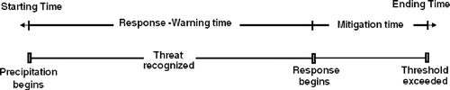
Apart from pre-flood measures, it is important to have a satisfactory flood warning system. The milestones in the occurrence of a flood event are shown in The first milestone is the beginning of the precipitation that causes the flood and the last is the exceedence of a water-level threshold at which property damage, injuries or loss of life occur. Actions taken by the public or public servants between these milestones may mitigate the flood damage. The time between the beginning of precipitation and the threshold exceedence is the maximum potential warning time. During the response-warning time, the threat is recognized and actions such as data collection, evaluation, notification and decision making take place (Carsell et al., Citation2004). During the mitigation time, efforts are made to prevent hazards from developing into flood disasters, or to reduce the effects of the flood.
Fig. 3 Flood time line.
The installation of telemetric meteorological and hydrometric stations in the basin is essential for a successful flood forecasting-warning system. Meteorological and hydrometric data have to be recorded in real time. The collected information is the “input” for the hydrological-hydraulic modelling that forecasts flood events. In the basin of interest, three telemetric hydrometric and three telemetric meteorological stations allow for monitoring on-line the hydrological and meteorological conditions of the watershed.
The hydrological response of the basin was simulated by coupling the HSPF model and a karst–snowmelt model. The final simulation results were in very good agreement with the observed field data (Kourgialas et al., Citation2008, Citation2010). A previous study concerning the hydrographs and rainfall characteristics from stations H1 and M3 (Fig. 2) showed a concentration time (forecasting horizon) of approximately 19 hours. In most cases, this is adequate time to recognize an oncoming extreme flood event and inform the local authorities (Kourgialas & Karatzas, Citation2009).
Since flooding is a complex and inherently uncertain phenomenon, its forecasts are also uncertain. The uncertainties of a flood forecast have three main sources: (a) measurement uncertainty, (b) meteorological forecasting uncertainty, and (c) hydrological model uncertainty (Krzysztofowicz, Citation2001). The first source depends on the data quality, the second is affected by model uncertainty as well as data quality, and the third is more model-specific. In the case of the Koiliaris River basin, the combined uncertainty is small enough to be characterized as satisfactory because of the small size of the basin, the availability of real-time measurements and the use of very good hydrological simulation programme.
The Flood Hazard Research Centre (FHRC) in the UK reviewed the flood response and suggested that the avoided actual flood damage, Da can be estimated as:
where Dp is the maximum potential flood damage avoided with a fully effective system; R is the reliability of the flood warning system; Pa is the proportion of residents available to respond to a flood warning; Pr is the proportion of households which will respond to a flood warning or have others who will do so for them; and Pe is the proportion of households which respond effectively (Carsell et al., Citation2004).
Each of these factors takes a value between 0.0 and 1.0 representing the efficiency of the system components. The recommended value for parameter Pa is 0.55 if warnings are limited to “loudhailer” or siren warnings, 0.65 in situations where “flood wardens” are used along with other warning methods, 0.80 with warning lead times between 6 and 8 hours. For parameter Pr , the recommended value is 0.75 without help from friends or family and 0.80 with help from friends or family. The value of Pe ranges between 0.70 and 0.95, and finally the value of R ranges between 0.0 and 1.0 based on the reliability of the flood warning system.
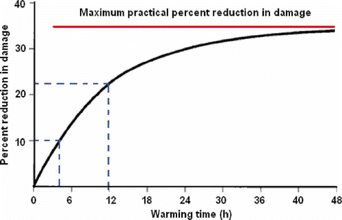
In order to calculate the maximum potential flood damage avoided using a fully effective system, Dp , Day's method was used. Day (Citation1970) proposed that the tangible benefit of a FWS is estimated as a function of the warning time, and developed the Day curve (). According to the Day curve, the maximum possible reduction in damage is about 35% of the total flood damage, independent of the warning time. This is reasonable since part of the property such as structures cannot be moved from the flood area. However, the Day curve should be calibrated to account for the differences in residential structures between 1970 and the present, and for other regional and system differences. This has emphasized the need for better data on flood damage and losses, to provide the right shape of the loss-probability curve (Penning-Rowsell & Green, Citation2000).
Fig. 4 Day curve (Carsell et al., 2004).
The three meteorological stations in the Koiliaris River basin in 2007 are strategically located at elevations 0, 400 and 1000 m a.m.s.l. in order to describe the spatial variability of the rainfall field.
EquationEquation (1)(1) and Day's method were used to estimate the actual avoided flood damage in the Koiliaris River basin. Assuming a value of 0.9 for the reliability of the current flood warning system, R (0.1 deduction for uncertainties of flood forecast), Equationequation (1)
(1) yields Da
= 0.35 × 0.9 × 0.65 × 0.8 × 0.9 = 14.74%. Thus, if a flood event had occurred in the basin before the installation of the Flood Forecasting-Warning System that had caused damages of €100 000, the benefit of this system would have been €14 740.
2.2.3 Post-flood measures
In the first few hours after a flood, a number of actions should be taken in the Koiliaris River basin to eliminate and mitigate its consequences:
-
The causes of the flood and the degree of destruction should become known in all regions affected.
-
The local authorities should evaluate the possibilities and the type of external assistance.
-
The local authorities should take action for the post-flood period. They have to ensure that the repairs of the destroyed structures will be completed before the next flood event takes place and to make the essential steps to decrease the danger of future floods. These actions include: (i) the removal of destroyed structures from the flooded regions, (ii) the control of land use that will direct the growth to the secure regions, (iii) campaigns and briefing for the public, (iv) flood-preventing protection to existing buildings, and (v) projects for retaining water that constitutes a flood danger.
3 ESTIMATION OF FLOOD-HAZARD AREAS IN THE KOILIARIS RIVER BASIN
The need for estimation of hazardous areas and of the exposure of a region to various phenomena, and to natural disasters in particular, emerged long before the application of computers and the development of specialized software for cartography. Initially, it was applied to groundwater contamination problems and later it expanded to natural disasters such as earthquakes, floods and soil erosion. The estimation of hazardous areas is a fundamental non-structural measure to address the management of the territory along the river channel.
The basic rule for the estimation of flood-hazard areas is the classification of the region into categories based on the degree of hazard (very high, high, moderate, low and very low). This classification is performed by considering the factors that form and influence a flood and by assigning relative weights to them. This process is performed in a GIS environment, and thematic maps are produced for every parameter. The linear combination of the thematic maps and the selection of the weights yields the map of hazardous areas. Modern scientific, administrative and legislative practices consider the estimation of flood-hazard areas as an important approach for a more effective management and protection of the anthropogenic and natural environment.
3.1 Methods of identification and analysis of the variables for the estimation of the hazardous areas
For the estimation of the flood-hazard areas in the Koiliaris River basin, six thematic-layer factors (variables) were created using a GIS ArcMap environment: flow accumulation, slope, elevation, rainfall intensity, land use and geology. All of these variables were georeferenced to the Greek Coordinate System EGSA’87. The produced raster maps were 20 × 20 m, i.e. a 400 m2 raster unit. The selection of the particular variable set for the estimation of the hazardous areas is discussed in the following.
Flow accumulation is an indirect way of measuring drainage areas (in raster units) and increases constantly from the drainage divides to the outlet and river channels (Schäuble et al., Citation2008). The topographic parameters of slope and elevation are inversely proportional to the appearance of floods (Kwak & Kondoh, Citation2008).
In small river basins, rainfall intensity and soil moisture conditions are the most important parameters in the generation of flash flood events (Camarasa Belmonte & Segura Beltran, Citation2001). Soil moisture conditions relate directly to land use as the vegetation cover controls both the amount and the time of precipitation reaching the soil surface. Geology plays a catalytic role in the runoff generation; for example, a karst structure decreases the overland flow. Moreover, the curve number (CN) as a useful parameter for determining flood runoff is related to land use, soil moisture and rainfall intensity (Svoboda, Citation1991).
The factors used in this study were selected for their general relevance to the flood hazards and according to literature surveys (Eimers et al., Citation2000; Yahaya et al., Citation2010). The above-mentioned six factors capture the appropriate information and avoid an unnecessary level of complexity in spatial modelling, thereby improving the utility of risk modelling for decision-making (Zerger, Citation2002).
The original data include topographic maps (1:50 000 and 1:5000) and monthly rainfall values from the seven stations located in both the area of study and the surrounding area. The digital elevation model (DEM)—spatial resolution of 20 × 20 m—for the terrain was first created from the slope map produced by using the three-dimensional (3-D) Analyst tool. Remote sensing methods (aerial photographs) and the traditional field explorative geological mapping were used to determine the land-use and geological maps of the Koiliaris River basin (Su, Citation2000). The 3-D DEM was used to determine the flow direction in each raster cell. This process was followed by identification of the water accumulation points. The flow concentration map, which indicates the number of cells that contribute hydrologically to each raster cell (Schäuble et al., Citation2008), was developed by using the flow-direction map combined with a suitable algorithm (flow accumulation—ArcHydro). Output cells with a high flow accumulation (pixels) are areas of concentrated flow. This map is very important since it identifies the locations where water accumulation occurs.
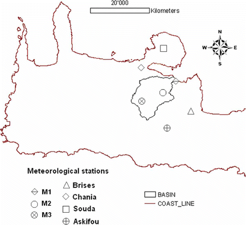
In order to determine the rainfall intensity, the meteorological data of the seven meteorological stations in and out of the Koiliaris River basin, shown in , recorded in the period 1975–2007 were used.
Fig. 5 Location of the meteorological stations.
The rainfall intensity map was created by using the Modified Fournier Index methodology (Morgan, Citation2005):
where MFI is the modified Fournier index, the 12-month summation, p is the average monthly rainfall, and P is the average annual rainfall.
The MFI expresses the sum of the average monthly rainfall intensity at a station. In the present study, at each station the territorial contribution of the MFI values were considered using the spline interpolation method. Various interpolation methods have been proposed for spatially-distributed rainfall data. Besides geostatistical approaches, such as ordinary kriging and co-kriging (Goovaerts, Citation2000; Lloyd, Citation2005), other techniques based on splines (Burrough, Citation1986; Hutchinson, Citation1998) or genetic algorithms (Huang et al., Citation1998) have been applied. According to these studies, the spline interpolation method is the most appropriate for cases with a small number of data points such as the case under study.
3.2 Results and discussion
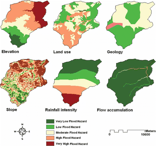
The six factors introduced in the previous section were used to estimate the flood-hazard areas, and create the corresponding map. Among these factors, flow accumulation, slope, elevation and rainfall intensity have numeric values, whereas geology and land use are expressed in descriptive form. The effect of each factor is mapped as five different hazard levels: very high, high, moderate, low and very low.
In the case of the numeric-valued factors, five different hazard classes were identified on the basis of the Jenk's Natural Breaks method, which allows one to determine these classes statistically by finding the adjacent feature pairs between which there is a relatively large difference in data value (Smith, Citation1986).
In the case of the non numeric-valued factors, classification depends mainly on the influence of the factor on the recharging flood process. For instance, for the geology factor, a karstic geology indicates a very low flood hazard. In the case of the land-use factor, limited land cover indicates a very high flood hazard.
The classification of the six factors into hazard levels is presented in . The proposed rating for the hazard levels (expert judgment), in points, is also shown in : Very High = 10, High = 8, Moderate = 5, Low = 2, Very Low = 1.
Table 1 Categorization: calibration and weight evaluation of the factors affecting flood-hazard areas in Koiliaris River basin.
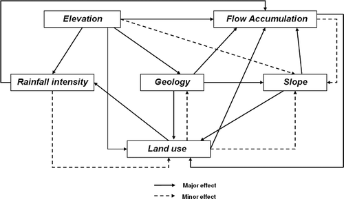
The hazardous areas cannot be estimated by considering the effect of each factor separately. The integration of all factors is necessary in order to obtain the overall map of flood-hazard areas. Since all factors do not have the same degree of influence on the hazardous areas, a weighting approach, in which a different weight is assigned to each factor, was applied. The factor weights were determined by employing the methodology presented by Shaban et al. (Citation2001), which considers the effect of each factor on all other factors. The interactions between the factors are depicted in . A solid line between two factors indicates that one factor has a main effect on the other pointed to by the arrow; that is, a change of the first factor has a direct effect on the other (main avenue). A dashed line between two factors indicates that one factor has a secondary effect on the factor pointed to by the arrow; that is, a change of the first factor has an indirect effect on the other (minor avenue). For example, flow accumulation has a main effect on land use and a secondary effect on slope. In order to quantify the two different types of effects, one (1) point is assigned to a main effect and half a point (½) to a secondary (Shaban et al., Citation2006). Then, the rate for a factor is computed as the summation of the points corresponding to the effects emanating from the factor. The rates for the factors depicted in are as follows:
Fig. 6 A schematic depiction of the interaction between factors that influence the flood hazard.
-
Flow accumulation: 1 major + 1 minor = 1 * 1 + 1 * 0.5 = 1.5 pts
-
Slope: 2 major + 0 minor = 2 * 1 + 0 * 0.5 = 2.0 pts
-
Land use: 2 major + 2 minor = 2 * 1 + 2 * 0.5 = 3.0 pts
-
Rainfall intensity: 1 major + 1 minor = 1 * 1 + 1 * 0.5 = 1.5 pts
-
Geology: 3 major + 0 minor = 3 * 1 + 0 * 0.5 = 3.0 pts
-
Elevation: 4 major + 1 minor = 4 * 1 + 1 * 0.5 = 4.5 pts
Based on the results, the rate weight of the elevation factor is significantly higher than the rainfall intensity. This has been confirmed by previous studies, indicating a greater intensification of rainfall with increasing elevation (Malby et al., Citation2007).
For a comprehensive evaluation of each factor related to hazardous areas, the rates and weights must be combined. This can be achieved by multiplying the proposed weight by the rate of effect, which yields the total weight of each factor (Shaban et al., Citation2006). The summation of all the factor weights yields the grand total weight (). The contribution of each factor to the hazardous areas, expressed as a percentage, is shown in the last column of . The percentage of each factor was computed as the ratio of the total factor weight to the grand total.
The resulting map of hazardous areas includes the combination of the above six variables which are related directly to any flood event that occurs in the area of study. Specifically, the six maps that were developed after the classification method () were combined using a weighted linear combination approach in a GIS environment.
Fig. 7 Flood hazard maps for each factor.
According to this technique, each factor is multiplied by its percentage weight (numeric overlay) and the summation of all factors yields the final map of hazardous areas (Gemitzi et al., Citation2006):
where S is the final map of hazardous areas, wi is the weight of factor i (percentage) and xi is the rate of the factor i.
The factors (thematic layers) were combined according to Equationequation (3)(3) in the Model Builder (GIS) environment. The Model Builder is a geoprocessing ability of the new edition of ArcView GIS 9.2 that is constituted of a chain of processes connected to each other and executed simultaneously.
The thematic-level maps of the effect of each hazard-area factor () were created using Equationequation (3)(3); these maps were combined with the weighting approach (GIS Model Builder) of the thematic levels and the final map of flood-hazard areas was produced ().
Fig. 8 Final flood-hazard map for the Koiliaris River basin.
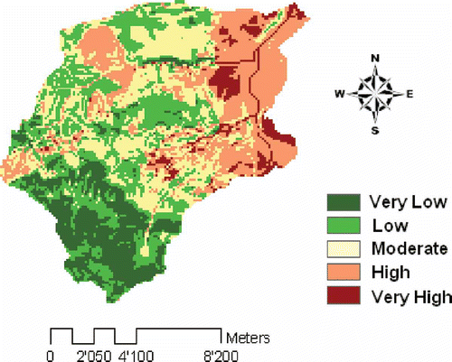
The areas of very high flood hazard, as determined by the GIS modelling methodology, are shown in , in which the flooded points according to historical records for the period 1960–2007 are also shown. Almost all of the recorded floods took place in the identified areas of very high flood hazard with only few taking place in the areas of high flood hazard. This fact validates the reliability of the applied methodology.
Fig. 9 Areas of very high flood hazard: settlements at risk and the reliability of the GIS model according to historical inundations.
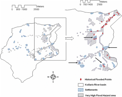
The black arrows in indicate the settlements in areas of high danger of flooding, where the local authorities, apart from taking the technical measures, should publicize the information regarding the flood-hazard areas and take all the necessary safety measures. More specifically, the local authorities should run campaigns (posters, maps, leaflets, etc.) and organize briefings (in schools, the city hall or other public places) in order to inform the residents about the hazardous areas. As for the local society, the citizens should in turn be able to recognize and conform to the warning signals, follow the evacuation plans, and stay far away from areas with very high flood hazard. They should also be informed as to whether their property is in a high-risk region, as well as of the preventive measures that should be applied in such a case. Finally, rescue services should be able to provide equipment and training, have at their disposal local maps indicating the high danger areas and watch for changes in the geomorphology of the rivers on a regular basis.
4 CONCLUSIONS
A method to evaluate the benefits of a flood warning system is presented, as well as a method to estimate the hazardous areas. The estimation of the flood-hazard areas is a fundamental component of a flood management strategy. The proposed approach was applied to the Koiliaris River basin in order to determine the areas and settlements in danger of flooding. The obtained results were validated against data from historical floods in the basin. Since flood phenomena occur in the area of study, the methodology presented in this paper could become a useful tool for the prediction of potential flooding areas and for the better organization of a flood management plan. Furthermore, the combination of this method with an effective forecasting-warning system based on Day's method can be used to avoid flood damage and ensure public safety.
Related Research Data
REFERENCES
- Adger , W. N. 2006 . Vulnerability . Global Environ. Change , 16 ( 3 ) : 268 – 281 .
- Barbetta , S. , Melone , F. and Moramarco , T. 2006 . Common methodologies for storm prediction and flood forecasting. Tech. Report FLOODMED Project, (Action 3.1) , Italy : Research Institute for Geo-Hydrological Protection (IRPI-CNR) . Interreg IIB cases
- Bonacci , O. , Ljubenkov , L. and Roje-Bonacci , T. 2006 . Karst flash floods: an example from the Dinaric karst (Croatia) . Natural Hazards and Earth System Sci. , 6 ( 2 ) : 195 – 203 .
- Bouwen , B. and Taillieu , T. 2004 . Multi-party collaboration as social learning for interdependence: developing relational knowing for sustainable natural resource management . J. Community Appl. Social Psychol. , 14 ( 3 ) : 137 – 153 .
- Boyle , D. P. , Gupta , H. V. , Sorooshian , S. , Koren , V. , Zhang , Z. and Smith , M. 2001 . Towards improved streamflow forecasts: the value of semi-distributed modeling . Water Resour. Res. , 37 ( 11 ) : 2749 – 2759 .
- Burrough , P. A. 1986 . Principles of Geographical Information System for Land Resources Assessment , Oxford : Oxford University Press . Monographs on Soil and Resources Survey no.12
- Camarasa Belmonte , A. M. and Segura Beltran , F. 2001 . Flood events in Mediterranean ephemeral streams (ramblas) in Valencia region, Spain . Catena , 45 ( 3 ) : 229 – 249 .
- Carsell , K. M. , Nathan , D. P. and Ford , T. D. 2004 . Quantifying the benefit of a flood warning system . Natural Hazards Review , 5 ( 3 ) : 131 – 140 .
- Carver , S. J. 1991 . Integrating multi-criteria evaluation with geographical information systems . Int. J. Geogr. Inf. Systems , 5 ( 3 ) : 321 – 339 .
- CEC (Commission of European Communities) . 2000 . Establishing a framework for community action in the field of water policy. Directive 2000/60/EC of the European Parliament and of the Council of 23 October 2000. Brussels . Official Journal of the European Communities 22.12.2000 L 327. ,
- CEC (Commission of European Communities) . 2007 . Directive 2007/60/WE of the European Parliament and of the Council 23 October 2007 on the Assessment and Management of Flood Risk. Brussels . Official Journal of the European Communities 6.11.2007 L 288. ,
- Day , H. J. 1970 . Flood warning benefit evaluation-Susquehanna River Basin (urban residences) , Silver Spring, MD : National Weather Service . ESSA Tech. Memo. WBTM Hydro-10
- Eastman , J. R. , Weigen , J. , Kyem , P. A. and Toledano , J. 1995 . Raster procedures for multi-criteria/multi-objective decisions . Photogram. Engng Remote Sensing , 61 : 539 – 547 .
- Eimers , J. L. , Weaver , J. C. , Terziotti , S. and Midgette , R. W. 2000 . Methods of rating unsaturated zone and watershed characteristics of public water supplies in North Carolina. Raleigh, NC . Water Resour. Invest. Report 99–4283 ,
- Ford , D. T. 2001 . Flood-warning decision-support system for Sacramento, California . J. Water Resour. Plan. Manage. , 127 ( 4 ) : 254 – 260 .
- Franchini , M. and Lamberti , P. 1994 . A flood routing Muskingum type simulation and forecasting model based on level data alone . Water Resour. Res. , 30 ( 7 ) : 2183 – 2196 .
- Gallopin , G. C. 2006 . Linkages between vulnerability, resilience and adaptive capacity . Global Environ. Change , 16 ( 3 ) : 293 – 303 .
- Gemitzi , A. , Petalas , C. , Tzihrintzis , V. A. and Pisinaras , V. 2006 . Assessment of groundwater vulnerability to pollution: a combination of GIS, fuzzy logic and decision making techniques . Environ. Geol. , 49 ( 5 ) : 653 – 673 .
- Goovaerts , P. 2000 . Geostatistical approaches for incorporating elevation into the spatial interpolation of rainfall . J. Hydrol. , 228 ( 1-2 ) : 113 – 129 .
- Green, C. H., Parker, D. J. & Tunstall, S. M. (2000) Assessment of Flood Control and Management Options. Thematic Review IV.4 prepared as an input to the World Commission on Dams, Cape Town http://www.dams.org (http://www.dams.org)
- Huang , Y. , Wong , P. and Gedeon , T. 1998 . Spatial interpolation using fuzzy reasoning and genetic algorithms . J. Geogr. Inf Decision Analysis , 2 ( 2 ) : 204 – 214 .
- Hutchinson , M. F. 1998 . Interpolation of rainfall data with thin plate smoothing splines. II. Analysis of topographic dependence describing or pertaining to special regions . J. Geogr. Inf. Decision Analysis , 2 ( 2 ) : 152 – 167 .
- Kourgialas , N. N. and Karatzas , G. P. The generation of karst flash floods and the analysis of their main hydrologic parameters; case study of the Koiliaris River Basin in Crete, Greece . Proc. 7th Int. Conf. of the European Water Resources Association . June 25–27 2009 , Limassol, Cyprus. pp. 403 – 410 . ISBN 978-9963-671-94-6
- Kourgialas , N. N. , Karatzas , G. P. and Nikolaidis , N. P. Simulation of the flow in the Koiliaris River basin (Greece) using a combination of GIS, the HSPF model and a karstic–snow melt model . 4th Biennial International Congress of iEMSs . Barcelona, Spain. pp. 512 – 520 . vol. 1
- Kourgialas , N. N. , Karatzas , G. P. and Nikolaidis , N. P. 2010 . An integrated framework for the hydrologic simulation of a complex geomorphological river basin . J. Hydrol. , 381 : 308 – 321 .
- Krzysztofowicz , R. 2001 . The case for probabilistic forecasting in hydrology . J. Hydrol. , 249 ( 1-4 ) : 2 – 9 .
- Kwak , Y. and Kondoh , A. 2008 . A study on the extraction of multi-factor influencing floods from RS image and GIS data; a case study in Nackdong basin, S. Korea. Beijing . The International Archives of the Photogrammetry, Remote Sensing and Spatial Information Sciences , XXXVII ( Part B8 ) : 421 – 426 .
- Lamberti , P. and Pilati , S. 1996 . Flood propagation models for real time forecasting . J. Hydrol. , 175 : 239 – 266 .
- Lloyd , C. D. 2005 . Assessing the effect of integrating elevation data into the estimation of monthly precipitation in Great Britain . J. Hydrol. , 308 ( 1-4 ) : 128 – 150 .
- Malby , A. R. , Whyatt , J. D. , Timmis , R. J. , Wilby , R. J. and Orr , H. G. 2007 . Long-term variations in orographic rainfall: analysis and implications for upland catchments . Hydrol. Sci. J. , 52 ( 2 ) : 276 – 291 .
- Manfreda, S., Sole, A. & Fiorentino, M. (2008) Can the basin morphology alone provide an insight into floodplain delineation? WIT Trans. Ecol. Environ. 118, 47–56 http://www.witpress.com (http://www.witpress.com)
- Michaud , J. D. and Sorooshian , S. 1994 . Comparison of simple versus complex distributed runoff models on a midsize semiarid watershed . Water Resour. Res. , 30 ( 3 ) : 593 – 605 .
- Ministry of Agriculture of Greece (2000) The Greek agriculture in numbers: Basic characteristics http://www.minagric.gr/ (http://www.minagric.gr/)
- Moramarco , T. , Barbetta , S. , Melone , F. and Singh , V. P. 2006 . A real-time stage Muskingum forecasting model for a site without rating curve . Hydrol. Sci. J. , 51 ( 1 ) : 66 – 82 .
- Morgan , R. P. C. 2005 . Soil Erosion and Conservation , Oxford : Blackwell Publishing Ltd .
- O'Connell , P. E. and Clarke , R. T. 1981 . Adaptive hydrological forecasting—a review . Hydrol. Sci. Bull. , 26 ( 2 ) : 179 – 205 .
- Pahl-Wostl , C. 2006 . The importance of social learning in restoring the multifunctionality of rivers and floodplains . Ecology and Society , 11 ( 1 ) : 10
- Parker , D. , Tapsell , S. and McCarthy , S. 2007 . Enhancing the human benefits of flood warnings . Natural Hazards , 43 ( 3 ) : 397 – 414 .
- Penning-Rowsell , E. C. and Green , C. 2000 . New insights into the appraisal of flood-alleviation benefits: (1) Flood damage and flood loss information . Water Environ. J. , 14 ( 5 ) : 347 – 353 .
- RPA (Risk and Policy Analysts Ltd) . 2005 . Evaluating a multi-criteria analysis methodology for application to flood management and coastal defence appraisals , London : Defra . Technical report
- Scawthorn , C. , Blais , N. , Tate , E. , Mifflin , E. , Thomas , W. , Murphy , J. and Jones , C. 2006 . HAZUS-MH flood loss estimation methodology. I: overview and flood hazard characterization . Natural Hazards Rev. , 7 ( 2 ) : 60 – 71 .
- Schäuble , H. , Marinoni , O. and Hinderer , M. 2008 . A GIS-based method to calculate flow accumulation by considering dams and their specific operation time . Comput. Geosci. , 34 ( 6 ) : 635 – 646 .
- Shaban , A. , Khawlie , M. and Abdallah , C. 2006 . Use of remote sensing and GIS to determine recharge potential zones: the case of Occidental Lebanon . Hydrogeol. J. , 14 ( 4 ) : 433 – 443 .
- Shaban , A. , Khawlie , M. , Bou Kheir , R. and Abdallah , C. 2001 . Assessment of road instability along a typical mountainous road using GIS and aerial photos, Lebanon–eastern Mediterranean . Bull. Engng Geol. Environ. , 60 ( 2 ) : 93 – 101 .
- Smith , R. M. 1986 . Comparing traditional methods for selecting class Intervals on choropleth maps . The Profess. Geogr. , 38 ( 1 ) : 62 – 67 .
- Su , Z. 2000 . Remote sensing of landuse and vegetation for mesoscale hydrological studies . Int. J. Remote Sensing , 21 ( 2 ) : 213 – 233 .
- Svoboda , A. 1991 . Changes in flood regime by use of the modified curve number method . Hydrol. Sci. J. , 36 ( 5 ) : 461 – 470 .
- Directors , Water . 2003 . Core group on flood protection of the water directors (Europe): best practices on flood prevention, protection and mitigation . European initiative on flood prevention, 25.9.2003 ,
- Wright, J. M. & Monday, J. L. (1996) Addressing your community's flood problems: a guide for elected officials. Madison, WI: ASFPM Executive Office. ( http://www.floods.org/PDF/Addressing_Communitys_Flood_Problems.pdf (http://www.floods.org/PDF/Addressing_Communitys_Flood_Problems.pdf)
- Yahaya , S. , Ahmad , N. and Abdalla , R.F. 2010 . Multicriteria analysis for flood vulnerable areas in Hadejia-Jama'are River basin, Nigeria . Eur. J. Sci. Res. , 42 ( 1 ) : 71 – 83 .
- Yeh , C. , Willis , R. , Deng , H. and Pan , H. 1999 . Task oriented weighting in multi-criteria analysis . Eur. J. Operat. Res. , 119 ( 1 ) : 130 – 146 .
- Zerger , A. 2002 . Examining GIS decision utility for natural hazard risk modelling . Environ. Model. Software , 17 ( 3 ) : 287 – 294 .