Abstract
Floods from the middle part of the River Morava (eastern Czech Republic) are considered over the course of the past three centuries, the study being based on data derived from documentary evidence (1691–1880), measured peak water stages, Hk (1881–1920) and peak discharges, Qk (1916–2009), evaluated with respect to their N-year return period (HN and QN ). Changes in land use and water management (water reservoirs, channel modifications) are discussed, as are factors influencing runoff conditions in the Morava catchment. Decadal synthesis of flood series identifies the highest flood activity in the decades of 1911–1920 and 1961–1970 (11 floods each), 1831–1840, 1891–1900, 1901–1910 and 1931–1940 (10 floods each). Uncertainty in this series is related to some incompleteness of documentary data in the pre-1881 period. Very low flood frequency occurred in the 1990s–2000s, although the most disastrous floods were recorded in this particular period (July 1997 at Q 100 and March/April 2006 at Q 20–Q 50). Changes in flood frequency correspond partly to long-term changes in temperature and precipitation patterns.
Citation Brázdil, R., Řezníčková, L., Valášek, H., Havlíček, M., Dobrovolný, P., Soukalová, E., Řehánek, T. & Skokanová, H. (2011) Fluctuations of floods of the River Morava (Czech Republic) in the 1691–2009 period: interactions of natural and anthropogenic factors. Hydrol. Sci. J. 56(3), 468–485.
Résumé
Les crues du cours moyen de la Rivière Morava (est de la République Tchèque) sont étudiées sur les trois derniers siècles à partir de données tirées de témoignages documentaires (1691–1880), de hauteurs d'eau maximales mesurées, Hk (1881–1920) et de débits maxima, Qk (1916–2009), caractérisées par leur période de retour N (HN et QN ). L'analyse des transformations intervenues dans l'occupation du sol et la gestion de l'eau (bassins de retenue, modifications du lit) montre que ces changements ont largement influencé les conditions d'écoulement dans le bassin de la Morava. La synthèse décennale de la série de crues permet d'identifier les décennies qui présentent les plus fortes activités en termes de crues: 1911–1920 et 1961–1970 (11 crues chacune), 1831–1840, 1891–1900, 1901–1910 et 1931–1940 (10 crues chacune). L'incertitude dans cette série est à mettre au compte d'un certain nombre de lacunes dans les données documentaires de la période antérieure à 1881. Les décennies 1990 et 2000 sont marquées par une fréquence d'occurrence des crues très basse, alors que c'est au cours de cette période que les phénomènes les plus désatreux ont été enregistrés (Q 100 en Juillet 1997 et Q 20–Q 50 en Mars–Avril 2006). Les changements dans la fréquence d'occurrence des crues sont liés en partie aux évolutions et tendances à long terme des dynamiques de température et de précipitations.
1 INTRODUCTION
Floods are among the most important natural extremes occurring in the Czech Republic. They cause not only great material damage but also loss of human life. Several disastrous floods merit being mentioned here. In July 1997, a flood in Moravia and Silesia (the eastern part of the Czech Republic) led to the deaths of 52 people and caused damage worth around 62.2 billion Czech crowns (Soukalová et al., Citation1997; Matějíček, Citation1998; Matějíček & Hladný, Citation1999; Dostál et al., Citation2002). A flash flood in July 1998 in eastern Bohemia claimed six victims and caused damage worth 2 billion Czech crowns (Hančarová et al., Citation1999). The western part of the Czech Republic was affected by a flood in August 2002 that claimed 19 victims with material damage accounted at approx. 73 billion Czech crowns (Šercl et al., Citation2002; Hladný et al., Citation2004, Citation2005). Losses to a further important flood in March/April 2006 were somewhat lower; nine people died and the cost was 5.6 billion Czech crowns (Brázdil & Kirchner, Citation2007). The most recent flash floods, occurring in June–July 2009 in northern Moravia, claimed a total of 15 victims and caused damage estimated at 8.5 billion Czech crowns (Daňhelka & Kubát, Citation2009). A concentration of extreme floods in the 1990s–2000s are also recorded in many other European countries (e.g. Kundzewicz et al., Citation1999, Citation2005a,Citationb; Ulbrich et al., Citation2003a,Citationb; Jaun et al., Citation2008; Marsh, Citation2008; Schmutz et al., Citation2008), and are sometimes attributed to the influence of global warming (Kundzewicz et al., Citation2005b; Solomon et al., Citation2007).
The analysis presented in this paper focuses on flood variability of the River Morava (), the largest river in the eastern part of the Czech Republic. Before its confluence with the Danube, the Morava has a length of 353.1 km with a catchment area of 26 578 km2. The Dyje is its largest right-side tributary (catchment area 13 419 km2) and the Bečva is the largest left-side tributary (1626 km2). The highest discharges occur most frequently in March, followed by April, while the lowest discharges are recorded in September and October (Brázdil & Kirchner, Citation2007).
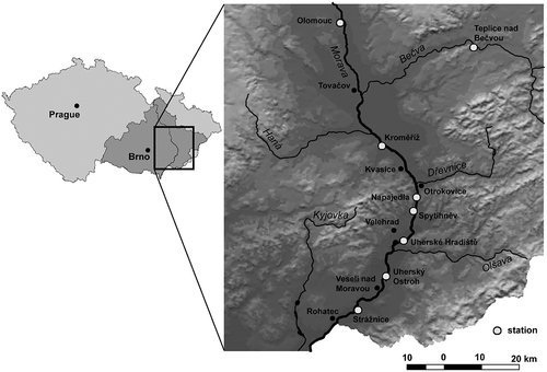
Fig. 1 Schematic illustration of the River Morava catchment in the territory of the Czech Republic, indicating the section of the river studied and the hydrological stations used in the study.
To date there have been few studies of flooding for the River Morava (with the exception of the July 1997 event) compared to other rivers in the Czech Republic, particularly the Vltava, the Elbe and the Ohře (see Brázdil et al., Citation2005a, for an overview). Kotrnec (Citation1976) analysed floods along the whole of the River Morava prior to the early 1970s. Matějíček (Citation1986) investigated the flood of 7–9 August 1985 on the Morava and the Bečva. Brázdil et al. (Citation2005a) worked on floods recorded for the Kroměříž station in the period 1881–2003 and supplemented the series with a chronology of floods of the River Morava from 1501, derived from documentary evidence. Brázdil & Kirchner (Citation2007) extended the Kroměříž analysis up to 2005 and presented floods at Strážnice for the years 1931–2005.
The aim of the present contribution is an analysis of flood variability in the middle part of the River Morava (between the Olomouc and Strážnice hydrological stations; ) for the period 1691–2009, based on systematic hydrological measurements and documentary evidence. In this section, the river flows through areas of intense agricultural use, known as the Hornomoravský and Dolnomoravský úval, which are large tectonic basins, and may be characterized as a lowland river with a broad floodplain. Several larger towns, among them Olomouc, Kroměříž, Otrokovice and Uherské Hradiště, are located along the river; their inhabitants and infrastructures are significantly threatened during floods.
The second section of this paper presents basic information about the hydrological stations used and what contributory documentary evidence exists. Section 3 focuses on factors that influence the runoff process, in terms of changes in land use and water management (weirs, water reservoirs, channel regulation works); Section 4 characterizes the occurrence of floods through systematic hydrological observations; and in Section 5, these floods are compared to floods derived from documentary evidence, with the aim of producing a synthesis and making a comparison to climate fluctuations. The last section summarises key knowledge derived from the analysis in a broader context.
2 HYDROLOGICAL DATA
Information about the occurrence of floods, their severity and impacts may be obtained from systematic hydrological measurements (the instrumental period) and from documentary evidence (the pre-instrumental period). Both these sources of data are described below.
2.1 Instrumental period
The water gauge stations on the River Morava arose out of a decree from the Imperial Austrian Ministry of the Interior dated 27 June 1876. This was subsequently absorbed into a further decree, that water stages at times of high water levels be observed, issued by the Moravian Governorship in August 1877 (Krška & Vlasák, Citation2008). A further instruction from the Moravian Building Authority also made direct mention of water gauge measurements. In the section of the River Morava studied here, systematic hydrological observations started in 1881 with measurements of water stages at the Kroměříž and Napajedla stations, then the Olomouc station in 1882. However, determination of peak discharges during floods began significantly later (). A further station at Rohatec in the Strážnické Pomoraví region began measurements of water stages in 1886. This was closed in 1940 and measurements moved 12 km upstream to Strážnice where discharges have been determined since 1920. From 1950 onwards, the Spytihněv station, located on the River Morava between Kroměříž and Strážnice, was also in operation. Within the period for which discharge values are available, floods with peak discharges, Qk , higher than peak discharges, QN, (with N-year return period; N = 2, 5, 10, 20, 50 and 100 years) were worked upon.
Table 1 Selected characteristics of the hydrological stations used for the study on the River Morava (Q a : long-term mean annual discharge, 1931–1980)
2.2 Pre-instrumental period
Various kinds of documentary evidence may be used to extend our knowledge of floods into the pre-instrumental period. They usually contain information about the date of flood occurrence, course and impacts, largely with respect to material damage and total number of casualties, and may be used to create long flood chronologies (e.g. Mudelsee et al., Citation2003, Citation2006; Brázdil et al., Citation2005b, Citation2006; Barriendos & Rodrigo, Citation2006; Böhm & Wetzel, Citation2006; Cyberski et al., Citation2006; Rohr, Citation2006; Glaser et al., Citation2010; Macdonald & Black, Citation2010). To date, only one flood chronology of the River Morava based on documentary evidence, going back to 1500, has been published (Brázdil et al., Citation2005a). Time periods insufficiently covered by documentary data—or even not at all—are immediately visible within that study; moreover, it also includes floods on the upper Morava that are not necessarily reflected in the river section studied in this paper. The existing series from 1691 onwards was therefore revised and complemented with information on further floods.
Among the most important documentary sources for flood data were:
-
Monastery diaries Relevant to this study were the diaries from the Hradisko Premonstratensian Abbey and its residence at Svatý Kopeček near Olomouc (Source: MZA – E55), which include daily weather records as well as information about floods. They cover 52 years from the period 1693–1783, in which 31 floods were reported. The River Morava inundated not only the property of the abbey, but Hradisko was often completely cut off from the town of Olomouc by flood water (Brázdil et al., Citation2008).
-
Claims for tax relief The First Moravian Land Registry, dating from 1655, indicates that Moravian farmers could claim tax relief in the event of damage resulting from hydrometeorological extremes, such as floods. First, a report of an event involving damage was sent to the regional office, which selected a commission to check the reliability of the account in situ. The commission's recommendation to the appropriate regional office approved or rejected the request for tax alleviation (Brázdil et al., Citation2003). A rich vein of documentation of this activity survives in the Moravian Land Archives in Brno and was used with reference to the following estates along the River Morava: Kvasice (Source: MZA – F301), Napajedla (MZA – F300), Strážnice (MZA – F90), Uherský Ostroh (MZA – F93), Velehrad (MZA – F207), and Veselí nad Moravou (MZA – F95).
-
River flow regulation documents Interest in making the River Morava navigable, as well as in addressing frequent flood damage, were reflected in attempts at regulating the river's flow. The documents associated with this, mainly at Moravian governmental level, contain not only technical information about actual attempts at regulation, but also short reports on floods that had already occurred (Source: MZA – B1, B14).
-
Chronicles and “books of memory” Information about floods also found its way into “books of memory”, chronicles kept for particular settlements within certain estates. One example covers Strážnice (Source: MZA – F90). Such accounts have also been used in several historical descriptions of settlements located close to the River Morava, but since they are secondary sources they have had to be cross-checked to avoid possible errors, particularly in dating.
3 FACTORS INFLUENCING THE RUNOFF PROCESS IN THE RIVER MORAVA CATCHMENT
Flood frequency and magnitude are influenced by catchment characteristics throughout the period of this study; these characteristics have changed as a result of anthropogenic and natural activities. Changes in land use, for example farming practices and regulation of watercourses largely for the purpose of accelerating runoff to the channel, have been considerable. In addition, the construction of structures such as dams, reservoirs and weirs have changed the hydrological characteristics of the catchment. However, it is difficult to quantify the impacts of these changes over long periods of time, such as those used within this study.
3.1 Changes in land use in the River Morava catchment
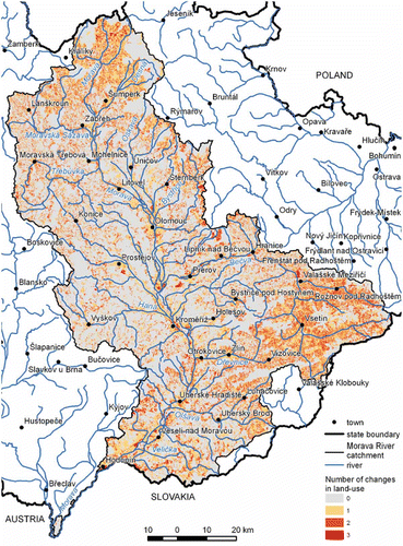
Land-use changes in the River Morava catchment may be studied from the river's source to its confluence with the River Dyje, an area of 9531.3 km2, for four periods by reference to the following maps: (a) the Second Austrian Military 1:28 800 Survey (SAMS) (from the years 1836–1841); (b) the Czechoslovak military topographical 1:25 000 maps (1952–1956); (c) the Czechoslovak and Czech military 1:25 000 topographical maps (1988–1995); and (d) the basic 1:10 000 topographical maps of the Czech Republic (2002–2006). While the SAMS map features the earliest sufficiently correct topographical base, maps from the 1950s render the period of “socialist collectivization” in agriculture, and those from the early 1990s reflect the socio-political changes initiated by events of 1989 (Mackovčin, Citation2009; Skokanová, Citation2009). A total of nine basic land-use categories were analysed, as shown in .
Table 2 Proportion (%) of individual categories of land use in the River Morava catchment (from its source to the Dyje mouth) in the four selected periods
Arable land proved the most extensive category of land use for all four periods (), with the highest proportion recorded in 1952–1956 (52.6%), decreasing continuously over the following two periods to the recent 41.5% (2002–2006). The second most extensive category was forest, the proportion of which rose steadily for the study period, from 28.4% to 37.3%. An opposite trend was recorded for the category of permanent grassland, for which a significant decrease had already begun by the end of the 19th century, which continued into the 20th century (from 21.3% at the beginning to 8.3% in the 1950s), though recent changes in management policies have reversed this trend somewhat in recent times. Built-up areas rose from 2.9% to 7.4% in the period studied, reflecting increases in population and consequent expansion of towns and villages. Examination of other land-use categories reveals relatively small proportional changes. Vineyards fluctuated at a range of 0.2–0.4%, while orchards gradually increased to a recent figure of 1.0%. Areas of water take up a small proportion of land use, fluctuating in the four time periods studied between 0.1 and 0.4%.
By comparing the four different time periods, a map showing a number of land-use changes was created (). No change occurred for 59.2% of the River Morava catchment. The highest proportion of stability involved arable land (30.5%) and forest (25.1%); the equivalent proportions for built-up areas (2.2%) and permanent grassland (1.3%) were notably lower. Parts in stable use such as vineyards, water resources, orchards, recreational areas, or for other purposes, occupied under 0.1% of the territory studied.
Fig. 2 Changes in land use of the River Morava catchment (from its source to the Dyje mouth) between the years 1836–1841 and 2002–2006.
3.2 Water management modifications
Efforts to regulate the River Morava are far from new. As early as 1653, the Moravian estates decided to make the River Morava navigable and connect it with the River Odra. In 1719 “Chief Sergeant” Norbert von Linck made a map of the River Morava to facilitate its regulation for navigational purposes (Source: MZA – D22; ). A series of further projects over the following decades focused on shipping and flood protection on the River Morava. However, they came to grief largely for a lack of essential financial resources (Weber von Ebenhof, Citation1894; Horák, Citation1911). Only the Waterways Law, passed in 1903, was eventually to provide a basis for Morava regulation when—based on plans by civil engineer J. Podhájský—a programme of regulation work was drawn up with the aims of:
retaining flood waters within reservoirs in the source area; Fig. 3 The section of the River Morava between Uherské Hradiště (Hradisch) and Rohatec (Rohatez) on the Norbert von Linck map, 1719 (Source: MZA – D22). The river was of anabranching character with several meandering channels in many places. 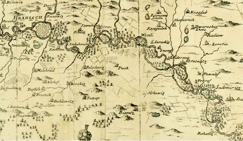 | |||||
draining high summer waters without flooding, by means of a relief channel; | |||||
allowing high spring waters to flood; and | |||||
demolishing weirs or building channels to aid water flow (Lorenc, Citation1928). | |||||
High weirs, which were largely associated with the construction of races for watermills, presented certain problems from the point of view of flooding and braiding of the river; moreover, their owners manipulated them much as they pleased, irrespective of general management needs.
3.2.1 Water reservoirs
The River Morava is among the few Czech water courses without reservoirs built on the main channel. However, 12 impoundment structures, large and small, exist on its tributaries () that were built in the first half of the 20th century, as part of water regulation works for flood protection. In contrast, the reservoirs built in the 1960s–1970s were intended as sources of drinking and service water for various conurbations. The Slušovice and Opatovice reservoirs (approx. 9.9 × 10⁶ m3 each) have the largest volumes, Horní Bečva and Ludkovice (approx. 0.7 × 10⁶ m3 each) the smallest. The total volume contained in all the reservoirs is 53.67 × 10⁶ m3 (Broža et al., Citation2005).
Table 3 Reservoirs on the tributaries of the River Morava (Broža et al., Citation2005)
3.2.2 Channel modifications
Modifications to the channel of the River Morava took place on the main, prevailing parts of the watercourse. They largely took the form of channel straightening through elimination of bends and meanders with the aim of accelerating runoff during floods. In total, some 45.6% of the whole length of the River Morava above the Bečva tributary is modified, i.e. 61.3 km of the complete length of 134.5 km (Zpravodaj, 2005).
Below the Bečva, practically the whole water course of the River Morava is modified with the exception of the section downstream of Vnorovy, where only local cuts to a total of 2.45 km were made at 120.8–133.3 km. A section at 172.5–173.7 km remains unmodified. Several adjustments to the River Morava took place even at the very beginning of the 20th century. In order to relieve flood discharges outside Uherský Ostroh and Veselí nad Moravou, an 9.3-km-long arm was built at 146.9 km on a turn above Uherský Ostroh. In order to reduce the areas inundated during floods, purpose-designed anti-flood dikes were built around Rohatec (3 km long), Hodonín (3.85 and 2.88 km), Vnorovy (12.225 km), Babice (0.83 km), and Otrokovice (1.5 km) (Zpravodaj, 2005).
3.2.3 The Baťa Channel
Among the attempts to render the Morava navigable was the Baťa Shipping Channel, built in 1934–1938. It was primarily intended to facilitate the transport of lignite from the Lužice coal field (downstream of the Strážnice area) to the Baťa factories in Otrokovice and Zlín (upstream). It was also to serve as a source of water for irrigation. Cargo transport ceased after only a few years of operation, but the channel found further employment for water management purposes. There were a total of 13 shipping locks on the River Morava and the Baťa Shipping Channel, some of which were repaired and reconstructed after 1989, and are once more in use for shipping. Water now passes down the artificial and natural River Morava channel. In recent times, the channel has become navigable for 65 km and has become an important tourist destination (Zpravodaj, 2005).
4 FLUCTUATIONS OF FLOODS OF THE RIVER MORAVA
4.1 Floods selected by discharge
The fluctuations of floods with peak discharge Qk ≥ Q 2, sorted by their N-year return period and occurrence in the summer (May–October) and winter (November–April) hydrological half-years, are shown for four hydrological stations in . The Olomouc station differs from the other downstream stations in its clear prevalence of winter floods over summer floods (77.4% to 22.6% in 1920–2009). For the remaining stations, the proportion of winter floods decreases to 53–55% and summer floods increase to 45–47%. March is the month with the most frequent floods for all stations (from 24.5% at Kroměříž to 28.3% at Olomouc). It is followed by floods in January and February (15.1% each) for Olomouc, while the three remaining stations have a secondary flood maximum in July (from 20.4% to 20.7%). The decade 1961–1970 saw the most frequent occurrence of floods, with the exception of Kroměříž, where floods were more frequent in 1931–1940.
Fig. 4 Variation of floods exceeding the two-year peak discharge Q 2 at four hydrological stations on the River Morava in the period 1916–2009 with respect to their N-year return period and their occurrence in the summer (1: May–October) and the winter (2: November–April) hydrological half-years (* denotes the half-years in which there occurred more than one flood with Qk ≥ Q 2; ↓ denotes the beginnings of the series of peak discharges).
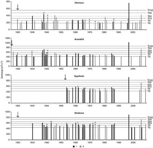
The most extreme flood in the period 1916–2009 was the summer flood of July 1997 which exceeded corresponding Q 100 values at all stations analysed. It arose out of intense rainfall on 5–8 July, when the daily precipitation totals at several stations increased to more than 200 mm d-1 (Štekl et al., Citation2001). The highest winter flood to date, at the turn of March/April 2006, attained peak discharges (Qk ) in the range of Q 50 for Strážnice and of Q 20 for the three remaining stations. It was associated with the melting of vast quantities of snow in the Morava catchment, accompanied by rains (Brázdil & Kirchner, Citation2007; Pinto et al., Citation2007). No other flood recorded at the four stations has reached Q 50.
Important to the creation of a flood chronology for the middle Morava is a correlation of floods between the various parts of the river section studied, as represented by the four selected stations. The aim is to find how the time of the occurrence and N-year return period of floods changes along the river, i.e. how the flood wave is transformed and to what extent it is influenced by the tributaries of the Morava. Therefore, the occurrence of floods at any particular station was always compared to floods at the next station downstream for the longest common observational period (). Only slightly more than a third of the Q 2 floods and more than half of the Q 5 floods at Olomouc were also recorded for stations downstream. This is also valid in nearly all cases for floods of Q 10 and Q 20 (with the exception of one case of Q 10 and one of Q 20 at Strážnice). The agreement of flood occurrence between sites increases further along the watercourse, particularly after the River Morava receives the Bečva tributary, the most important left-side tributary. As for Q 2 floods at Kroměříž, around 80% of them are also recorded at Spytihněv and Strážnice; for floods of Q 5 this proportion increases to 90–100%. Apart from these, there still exist a remarkable number of floods that are recorded further down the watercourse but are absent from the upstream station.
Fig. 5 Comparison of relative frequencies for the concurrent occurrence of floods with Q 2, Q 5, Q 10, Q 20 for station couples on the middle Morava (OLOM: Olomouc; KROM: Kroměříž; SPYT: Spytihněv; STRA: Strážnice), and/or on the Bečva (TEPL: Teplice nad Bečvou), always for the common longest period of measurements at the given couple of stations (see ). Figures at each couple indicate percentage of all common floods with Qk ≥ Q 2 in relation to the station downstream.
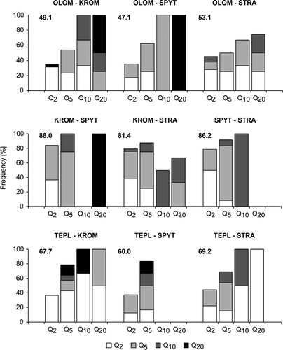
The importance of floods on the River Bečva to the occurrence of floods on the middle Morava may be documented in terms of floods at the Teplice nad Bečvou station in comparison with the stations at Kroměříž, Spytihněv and Strážnice (). More than two-thirds of the total number of floods at Bečva also occurred at Kroměříž and Strážnice, while full agreement was achieved for floods of Q 10 and Q 20. The proportion at Spytihněv, with a shorter common period of observation, is slightly lower.
4.2 Floods selected by peak water stages
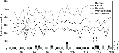
Because evaluation of discharges began later than systematic measurements of water stages, series of peak water stages must be used for flood determination in the 1881–1916 period. As well as the Olomouc and Kroměříž stations, the water gauge stations at Napajedla, Uherské Hradiště and Uherský Ostroh (see ) were also considered. In order to consider these additional stations it was necessary to recalculate the water stages measured to the same water-gauge base level, allowing for changes in altitude of the given station during the period studied. Fluctuations of peak annual water stages, Hk , for selected stations are shown in . Peak water stages, HN , with the return period of N years (N = 2, 5, 10, 20, 50 and 100) were calculated for the individual stations according to the three-parameter generalised extreme value distribution (distribution parameters estimated by the maximum likelihood method; Katz et al., Citation2002). In the 40-year period (1881–1920) there were only 12 years in which floods did not occur. Of particular interest was the year 1903, when flooding was recorded four times: in early January, February, July and November. Moreover, the flood of July 1903, arising out of heavy rains on 9–10 July, was extremely disastrous for the River Odra area, with loss of human life (Štekl et al., Citation2001; Brázdil et al., Citation2005a).
Fig. 6 Fluctuations of relative annual peak water stages at selected hydrological stations on the middle Morava in the years 1881–1920 and frequency of floods per year of the summer (1) and winter (2) types.
4.3 Floods in terms of documentary evidence
The first reports of floods on the River Morava, at Olomouc and Tovačov, are recorded without further exact dating in 1501, when pond retention banks were overcome and water mills damaged (Steinbach, Citation1783). The totals of 16 flood events in the 16th century and 16 floods in the 17th century mentioned in documentary sources () obviously do not express the actual number of floods that occurred in these centuries.
Table 4 List of floods recorded in documentary evidence for the middle Morava in the 16th–17th centuries
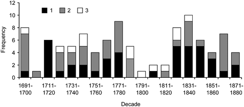
A flood chronology for the middle section of the River Morava compiled from documentary sources for the 1691–1880 period is presented in the form of decadal frequencies, separated into winter and summer floods (). This arrangement is not unambiguous for a number of floods that lack exact dating, and such types are characterized as “unclear”. It follows from that there was insufficient coverage in the years 1701–1710, nor was there any in 1791–1820, due to a simple lack of corresponding documentary evidence. In contrast, floods were most frequent in the decades 1831–1840 (10 floods), 1771–1780 (nine floods), 1691–1700 and 1821–1830 (eight cases each). While summer floods were dominant in 1711–1720 and 1821–1850, winter floods largely prevailed in 1691–1700, 1771–1780 and 1861–1870.
Fig. 7 Decadal frequencies of floods on the middle Morava according to documentary evidence in the period 1691–1880 and differentiation of flood types (1: summer, 2: winter, 3: unclear).
5 DISCUSSION
5.1 Synthesis of floods based on instrumental records and documentary evidence
The final synthesis of floods on the middle Morava is based partly on systematic hydrological measurements and partly on records of documentary evidence. In the instrumental period, floods are delimited statistically in terms of the values of peak discharges and peak water levels higher than any thresholds corresponding to N-year peak discharges and N-year peak water levels, respectively, and calculated from long time series. In this paper thresholds of peak discharges and peak water levels with return periods of two years (N = 2) were used for selection of floods.
Depending on the river channel capacity, it cannot be excluded that in lower N-year discharges (water stages) the river did not even leave its channel and inundate the flood plain; or that anthropogenic channel modifications resulted in increasing river channel capacity. On the River Morava, before regulation work in the 1930s, inundation of the flood plain in the Strážnické Pomoraví region was an almost annual phenomenon (often more than one overbank flood in a year); increasing channel capacity lowered the recurrence interval of flood-plain inundations to around the 5-year discharge (Q 5) figure.
In contrast to this delimitation, floods mentioned in the pre-instrumental period (documentary sources) are always described as cases of over-bank flow or inundation of the flood plain. However, in the past, unregulated rivers flooded almost every year at many locations, but written records were made only when events were out of the ordinary or had a direct impact; this coupled with lower occupation and use of the flood plain historically would have resulted in many inundations of the flood plain failing to attract any attention.
The above highlight some of the potential difficulties and possible uncertainties in the generation and analysis of the flood series for the middle Morava during the historical period.
5.2 Fluctuations of floods in the period 1691–2009
The decadal frequencies of floods in the instrumental period do not include cases when a flood occurred for only one of four stations analysed (being related to local phenomena, such as the creation of a temporary ice barrier or local torrential rain). With respect to the perennially difficult classification of flood severity from documentary sources, floods were further analysed only in terms of their frequency and seasonality.
Decadal frequencies of floods on the middle Morava () show that the highest number of floods per decade occurred in 1911–1920 and 1961–1970 (11 floods each), 1831–1840, 1891–1900, 1901–1910 and 1931–1940 (10 floods each). The numbers of floods in 1701–1710 and 1791–1820 are clearly underestimated, a fact related to lack of corresponding documentary sources. It follows that the increasing number of floods in particular centuries (49 events in the 18th, 60 in the 19th and 76 in the 20th centuries) reflect a comparison between available documentary-based information and systematic hydrological measurements.
Fig. 8 Decadal frequencies of the occurrence of floods on the middle Morava in the years 1691–2009 according to systematic instrumental measurements and documentary sources and differentiation of flood types (1: summer, 2: winter, 3: unclear).
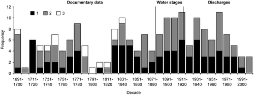
Fluctuations in floods on the River Morava coincide to varying degrees with existing flood series in the Czech Lands derived from similar methodological backgrounds. The Dyje, the largest tributary of the Morava, recorded maximum floods in the pre-instrumental period in 1711–1730, 1741–1750, 1811–1870 and 1891–1900. On the Bečva, the highest frequency of floods in documentary sources was reported for 1711–1720 and largely for 1871–1900 (Brázdil & Kirchner, Citation2007). Flooding of the Svratka and Svitava rivers at Brno exhibited maximum flood frequency in the periods 1810–1850 and 1920–1951 (Brázdil et al., Citation2011). Bohemian rivers showed the highest flood frequency for the past 300 years in the 19th century (the Vltava in 1851–1900, the Elbe and the Ohře in 1801–1850) (Brázdil et al., Citation2005a), while the middle Morava exhibited its maxima in 1901–1950.
The seasonality of floods on the River Morava in the instrumental period, water stage and discharge figures are largely in agreement. Winter floods (51.5% according to water stage data for 1881–1915 and 55.7% according to discharge figures for 1916–2009) prevailed over summer floods (48.5% and 44.3%, for stage and discharge data, respectively). Floods occurred most frequently in March (24.2 and 27.9%, respectively), followed by February in the first period (15.2%) and July in the second period (18.0%). The proportion of June–August floods increased between these two periods from 27.3 to 32.8%. In the documentary-based period 1691–1880, the relative frequencies of floods are influenced by a figure of 13.0% for non-classified cases. The proportions of winter and summer floods is similar (45.0 and 42.0%), but maximum frequency was recorded in June and March (13.0% each). This may be explained by the character of the documentary reports associated with tax relief, which tended in particular to reflect damage to meadows (mainly to hay) and fields in the River Morava flood plain.
5.3 Floods and land use
Floods have also been significantly influenced by changes in land use giving rise to changes in the retention capacity of the landscape. These changes can be characterized with appropriate accuracy from only the early 19th century onwards. In the whole River Morava catchment, 59.2% of the territory was in stable usage between 1836 and 2006, with arable land and forests as the most constant categories. Decreases in the area of permanent grassland (1836–1841, 21.3%; 1953–1956, 8.3%) and a three-fold increase in built-up areas in flood plains and lowlands are the most important changes in land use. Overall, the changes show increasing intensification of land use in the lowlands, plains and hilly lands, with processes related largely to afforestation and grassing of highlands and mountainous country.
The collectivization of agriculture in the second part of the 20th century had important impacts on original landscape structures. It led to land consolidation, the end of small holdings on the majority of the territory, the loss of game reserves, systems of field roads, linear and dispersed vegetation, “amelioration interventions”, and increased use of mechanisation for higher crop production. Forestry management had already been in flux since the latter half of the 19th century. Concurrently with the enlargement of the forested area, a significant reduction in original natural forests as well as of flood plain forests took place. This increase was related chiefly to the extension of areas for short-term financial gain, mainly in terms of the establishment of non-original spruce monocultures.
It is very difficult to identify any unambiguous relationships between floods and changes in land use. This in part relates to the long time span of this study, with no further land-use data between 1841 and 1952. From this reason only speculative remarks can be presented for the three periods (see also ):
-
1836–1841 and 1952–1956 An increase in arable land and decrease in permanent grassland worsened the ground water-holding capacity, i.e. intensified surface runoff (see high flood frequency in 1891–1920). Alternatively, increasing forest could have the opposite effect.
-
1952–1956 and 1988–1995 A decrease in arable land and increase in forested area should contribute to an increase in the ground water-holding capacity. However, changes mentioned in connection with the collectivization of agriculture could have the opposite effect (see high flood activity in 1961–1970).
-
1988–1995 and 2000–2006 Further decreases in arable land and an increase in permanent grassland and forest should be a positive factor for weaker surface runoff and higher ground water-holding capacity (see low flood frequency in the 1990s–2000s).
5.4 Synoptic causes of floods
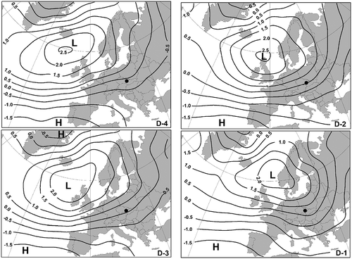
Typical synoptic patterns relating to floods of the River Morava were analysed using a set of daily 5° × 5° sea-level pressure (SLP) fields for the North Atlantic and Europe regions spanning the years 1850–2003 (Ansell et al., Citation2006). Snow melting after sudden warming, sometimes accompanied by ice-floe barriers on the river and liquid (rainfall) precipitation, contributes to the floods on the River Morava that largely occur in the winter half-year (November–April). At sea-level pressure, this situation is usually characterized by cyclones passing north of Central Europe when the Morava catchment is located in their warm sectors and deep snow cover is subject to intensive melt. This may be documented for the first principal component PC1 of the SLP field, calculated by the principal component analysis (PCA) for 26 winter floods of the Morava in the days D − 4 to D − 1, where D is the day of flood peak at the Kroměříž station (): PC1 explains around one third of the SLP field variability.
Fig. 9 Component scores of the first principal component PC1 calculated using PCA for 26 winter floods on the River Morava at Kroměříž in the days D – 4 to D – 1 for the period 1881–2003 (L: low; H: high). Explained variance of the SLP field: D – 4: 37.0%; D – 3: 37.1%; D – 2: 34.6%; and D – 1: 29.0%. The black dot shows the position of the Morava catchment.
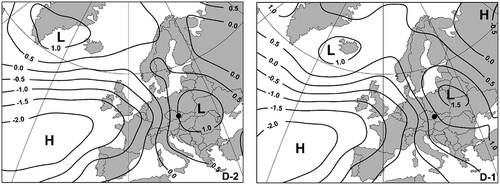
Floods on the River Morava in the summer half-year (May–October) are related to continuous heavy precipitation. This is often a response to Mediterranean cyclones passing over Moravia or east of the territory (the Vb van Bebber cyclone track; see, for example, van Bebber, Citation1881, Citation1883; Štekl et al., Citation2001; Mudelsee et al., Citation2004), as documented by PC1 of the SLP field for 26 summer floods of the River Morava in the days D – 2 and D – 1 (). The PC1 explains slightly more than a third of the SLP field variability.
Fig. 10 Component scores of the first principal component PC1 calculated using PCA for 26 summer floods on the River Morava at Kroměříž in the days D – 2 to D – 1 for the period 1881–2003 (L: low; H: high). Explained variance of the SLP field: D – 2: 36.7%; and D – 1: 35.6%. The black dot shows the position of the River Morava catchment.
5.5 Floods and climate change
Although floods result from certain extreme variations in meteorological and hydrological conditions, flood frequency may also reflect certain long-term climatic patterns. Information about climate fluctuations from 1691 onwards is based upon:
-
annual Central European temperatures compiled from documentary-based temperature indices for Germany, Switzerland and the Czech Lands up to 1759 and on homogenized series of 11 meteorological stations from Austria, Germany, Switzerland and the Czech Republic from 1760 onwards (Dobrovolný et al., Citation2010);
-
homogenized Brno temperature (from May 1799) and precipitation (from January 1803) series compiled from different parts of Brno and adjusted to the recent Brno-Tuřany airport meteorological station (Brázdil et al., Citation2005c); and
-
summer Brno precipitation totals compiled from documentary-based precipitation indices for the Czech Lands from 1701 to 1854.
The annual Central European temperatures, starting from the coldest decade of the 1690s, clearly express large inter-annual and decadal variability, when temperatures below the 1961–1990 mean prevailed. A general more-or-less continuous increase in temperatures started around 1890 and has culminated in the last two to three decades, which have been the warmest in the whole chronology ((a)). The same patterns are reflected in the Brno temperature series ((b)), indicating great spatial temperature coherency in the Central European region. Brno annual precipitation totals showed consistently high values, above the 1961–1990 mean, occurring mainly between 1875 and 1950 after the two driest decades that preceded them ((d)). Similar features are also visible in the summer precipitation totals, with some differences of drier and wetter time intervals ((c)). For example, the 1690s and 1730s were among the wettest decades prior to 1800. On the other hand, relatively drier periods started after 1970, with values fluctuating around the 1961–1990 mean.
Fig. 11 Temperature and precipitation fluctuations over the past 318 years: (a) annual Central European temperatures, 1691–2008; (b) annual Brno temperatures, 1799–2008; (c) summer Brno precipitation totals, 1691–2008; and (d) annual Brno precipitation totals, 1803–2008. Values are expressed as deviations from the corresponding 1961–1990 means and smoothed by Gaussian filter over 30 years.
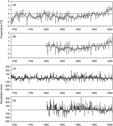
In comparing flood frequency with temperature and precipitation fluctuations, it is difficult to find clear relationships. The floods in the 1690s were related to cold and wet periods, as documented by the high proportion of winter floods. The increased frequency of summer floods between 1820 and 1850 is well reflected in higher precipitation totals, but with smaller totals in the 1830s. Increasing flood frequency in 1881–1920 corresponds well with above-mean precipitation and slightly increasing temperature, but remains below the 1961–1990 mean. A general decline in the number of floods from the 1960s to the 2000s is characterized by relatively low precipitation and increasing temperatures, corresponding well to recent global warming (Solomon et al., Citation2007).
6 CONCLUSIONS
Combining documentary evidence and systematic hydrological measurement has allowed the creation of a synthesis of series of floods in the middle Morava for the 1691–2009 period. Some parts of this series in the pre-instrumental period remain slightly underestimated and require further archive research. While, in the past, floods were almost annual phenomena (and sometimes occurred several times in a year), channel modifications in the first part of the 20th century significantly influenced the runoff regime and increased channel capacity. Changes in land use and the construction of various water modification works were important to the runoff process. Flood activity in the middle Morava culminated largely in 1821–1840, 1891–1920, 1931–1950 and 1961–1980. Flood frequency decreased significantly in 1991–2009, although, paradoxically enough, the most disastrous flood occurred in this period (July 1997).
This paper fills a gap that existed in the analysis of floods for the largest Moravian river, as previous work was undertaken on the main rivers in Bohemia (Brázdil et al., Citation2005a). The study of floods in the middle section of the River Morava was also motivated by the fact that several sedimentary profiles exist for its downstream section, in the Strážnické Pomoraví region, the dating of which shows deposition of alluvial sediments during the Holocene (Kadlec et al., Citation2009; Grygar et al., Citation2010). This implies that information about flood activity from this region is of importance in understanding of the development of the River Morava flood plain.
Over and above these facts, learning from past events is an important tool for better understanding floods and for the provision of more effective protective measures against possible future events. According to the conclusions of the Working Group II of the IPCC (Parry et al., Citation2007), the continuation of recent warming trends across Europe and changes in the water cycle are likely to increase the risk of floods in much of Europe. Recent 100-year return frequency floods should occur more frequently in the 2070s in much of Europe, including Central and Eastern Europe, something that may also involve the River Morava.
ARCHIVE SOURCES
-
MZA – B1: Moravský zemský archiv Brno, fond B1 Moravské gubernium (1048)1613–1785(1790), sign. 3962, 3964.
-
MZA – B14: Moravský zemský archiv Brno, fond B14 Moravské místodržitelství (1628)1786–1918, sign. 72.
-
MZA – D22: Moravský zemský archiv Brno, fond D22 Sbírka map a plánů 1575–1961, sign. 96.
-
MZA – E55: Moravský zemský archiv Brno, fond E55 Premonstráti Hradisko, sign. II-4 to II-43, II-45.
-
MZA – F90: Moravský zemský archiv Brno, fond F90 Velkostatek Strážnice 1556–1945, sign. 1, 2, 3, 4, 638, 831.
-
MZA – F93: Moravský zemský archiv Brno, fond F93 Velkostatek Uherský Ostroh 1693–1947, sign. 43, 49, 80, 154, 239, 245, 296.
-
MZA – F95: Moravský zemský archiv Brno, fond F95 Velkostatek Veselí nad Moravou 1652–1945, sign. 153.
-
MZA – F207: Moravský zemský archiv Brno, fond F207 Velkostatek Velehrad 1649–1952, sign. 112, 116.
-
MZA – F300: Moravský zemský archiv Brno, fond F300 Velkostatek Napajedla 1603–1928, sign. 87.
-
MZA – F301: Moravský zemský archiv Brno, fond F301 Velkostatek Kvasice 1729–1946, sign. 151.
Acknowledgements
This paper was prepared with financial support from the Grant Agency of the Academy of Sciences of the Czech Republic (Grant no. IAAX00130801): “Interrelationships among climate, anthropogenic activity and landscape erosion recorded in natural archives of the Strážnické Pomoraví (Czech Republic)”. M. Havlíček and H. Skokanová gratefully acknowledge support from research project MSM 6293359101: “Research into sources and indicators of biodiversity in the cultural landscape in the context of its fragmentation dynamics”. We would also like to thank Kateřina Chromá (Institute of Geography, Masaryk University Brno) for documentary data about floods from the Veselí nad Moravou estate, Tony Long (Svinošice, Czech Republic) for English style corrections and Denis Coeur (Biviers, France) for the French translation. One of two anonymous reviewers is acknowledged for constructive comments and proposed improvements to this article.
Related Research Data
REFERENCES
- Ansell , T. and 38 co-authors . 2006 . Daily mean sea level pressure reconstructions for the European–North Atlantic region for the period 1850–2003 . J. Climate , 19 ( 12 ) : 2717 – 2742 .
- Barriendos , M. and Rodrigo , F. S. 2006 . Study of historical flood events on Spanish rivers using documentary data . Hydrol. Sci. J. , 51 ( 5 ) : 765 – 783 .
- Bebber , W. J. van . 1881 . Die geographische Vertheilung und Bewegung, das Entstehen und Verschwinden der barometrischen Minima in den Jahren 1876 bis 1880 . Z. Öster. Ges. Meteorol. , 16 : 414 – 419 .
- van , Bebber, J. 1883 . Typische Witterungserscheinungen . Z. Öster. Ges. Meteorol. , 18 : 447 – 458 .
- Böhm , O. and Wetzel , K.-F. 2006 . Flood history of the Danube tributaries Lech and Isar in the Alpine foreland of Germany . Hydrol. Sci. J. , 51 ( 5 ) : 784 – 798 .
- Brázdil , R. , Černušák , T. and Řezníčková , L. 2008 . Weather information in the diaries of the Premonstratensian Abbey at Hradisko, in the Czech Republic, 1693–1783 . Weather , 63 ( 7 ) : 201 – 207 .
- Brázdil , R. , Dobrovolný , P. , Elleder , L. , Kakos , V. , Kotyza , O. , Květoň , V. , Macková , J. , Müller , M. , Štekl , J. , Tolasz , R. and Valášek , H. 2005a . Historické a současné povodně v České republice (Historical and recent floods in the Czech Republic, in Czech) , Brno, Praha : Masarykova univerzita, Český hydrometeorologický ústav .
- Brázdil , R. and Kirchner , K. , eds. 2007 . Vybrané přírodní extrémy a jejich dopady na Moravě a ve Slezsku (Selected natural extremes and their impacts in Moravia and Silesia, in Czech) , Brno, Praha, , Ostrava : Masarykova univerzita, Český hydrometeorologický ústav, Ústav geoniky Akademie věd České republiky, v.v.i .
- Brázdil , R. , Kundzewicz , Z. W. and Benito , G. 2006 . Historical hydrology for studying flood risk in Europe . Hydrol. Sci. J. , 51 ( 5 ) : 739 – 764 .
- Brázdil , R. , Pfister , C. , Wanner , H. , von Storch , H. and Luterbacher , J. 2005b . Historical climatology in Europe—the state of the art . Clim. Change , 70 ( 3 ) : 363 – 430 .
- Brázdil , R. , Valášek , H. and Macková , J. 2005c . Meteorologická pozorování v Brně v první polovině 19. století. Historie počasí a hydrometeorologických extrémů (Meteorological Observations in Brno in the First Half of the 19th Century. History of Weather and Hydrometeorological Extremes, in Czech) , Brno : Archiv města Brna .
- Brázdil , R. , Valášek , H. and Soukalová , E. , eds. 2011 . Povodně v Brně. Historie povodní, jejich příčiny a dopady (Floods in Brno. History of Floods, Their Causes and Impacts, in Czech) , Brno : Archiv města Brno (in press) .
- Brázdil , R. , Valášek , H. and Sviták , Z. 2003 . Meteorological and hydrological extremes in the Dietrichstein domains of Dolní Kounice and Mikulov between 1650 and 1849 according to official economic records of natural disasters . Geogr. Čas. , 55 ( 4 ) : 325 – 353 .
- Broža , V. , Satrapa , L. , Sakař , K. , Bláha , J. , Báča , V. , Vít , P. , Maníček , J. , Bíza , P. , Jílek , M. , Kopřivová , J. and Vinklát , P. D. 2005 . Přehrady Čech, Moravy a Slezska (Water Reservoirs of Bohemia, Moravia and Silesia, in Czech) , 555 Liberec : Knihy .
- Cyberski , J. , Grześ , M. , Gutry-Korycka , M. , Nachlik , E. and Kundzewicz , Z. W. 2006 . History of floods on the River Vistula . Hydrol. Sci. J. , 51 ( 5 ) : 799 – 817 .
- Daňhelka , J. and Kubát , J. , eds. 2009 . Přívalové povodně na území České republiky v červnu a červenci 2009 (Flash Floods on the Territory of the Czech Republic in June and July 2009, in Czech) , Praha : Ministerstvo životního prostředí ČR, Český hydrometeorologický ústav .
- Dobrovolný , P. , Moberg , A. , Brázdil , R. , Pfister , C. , Glaser , R. , Wilson , R. , van Engelen , A. , Limanówka , D. , Kiss , A. , Halíčková , M. , Macková , J. , Riemann , D. , Luterbacher , J. and Böhm , R. 2010 . Monthly and seasonal temperature reconstructions for Central Europe derived from documentary evidence and instrumental records since AD 1500 . Clim. Change , 101 ( 1–2 ) : 69 – 107 .
- Dostál , I. , Řehánek , T. and Papšíková , L. 2002 . Povodeň na řece Moravě v červenci 1997 (Flood on the River Morava in July 1997, in Czech) , 30 Praha : Český hydrometeorologický ústav, Práce a studie .
- Glaser , R. , Riemann , D. , Schönbein , J. , Barriendos , M. , Brázdil , R. , Bertolin , C. , Camuffo , D. , Deutsch , M. , Dobrovolný , P. , van Engelen , A. , Enzi , S. , Halíčková , M. , Koenig , S. J. , Kotyza , O. , Limanowka , D. , Macková , J. , Sghedoni , M. , Martin , B. and Himmelsbach , I. 2010 . The variability of European floods since AD 1500 . Clim. Change , 101 ( 1–2 ) : 235 – 256 .
- Grygar , T. , Světlík , I. , Lisá , L. , Koptíková , L. , Bajer , A. , Wray , D. S. , Ettler , V. , Mihaljevič , M. , Nováková , T. , Koubová , M. , Novák , J. , Máčka , Z. and Smetana , M. 2010 . Geochemical tools for the stratigraphic correlation of floodplain deposits of the Morava River in Strážnické Pomoraví, Czech Republic from the last millennium . Catena , 80 ( 2 ) : 106 – 121 .
- Hančarová , E. , Metelka , L. , Mrkvica , Z. , Pavlík , J. , Pozler , R. , Šiftař , Z. , Váchal , P. and Veselý , R. 1999 . Katastrofální povodeň v podhůří Orlických hor ve dnech 22. až 25. 7. 1998 (Catastrophic flood in foothills of the Orlické hory Mountains on 22–25 July 1998, in Czech) . Meteorol. Zpr. , 52 ( 1 ) : 1 – 12 .
- Hladný , J. , Kašpárek , L. , Krátká , M. , Kněžek , M. and Martínková , M. 2005 . Katastrofální povodeň v České republice v srpnu 2002 (Disastrous Flood in the Czech Republic in August 2002, in Czech) , Praha : Ministerstvo životního prostředí .
- Hladný , J. , Krátká , M. and Kašpárek , L. , eds. 2004 . August 2002 Catastrophic Flood in the Czech Republic , Prague : Ministry of Environment of the Czech Republic .
- Horák , J. 1911 . “ O regulaci řeky Moravy. Historie a popis projektu (About the River Morava regulations ” . In History and project description, in Czech), 131–173 , Brno : Zprávy Spolku českých inženýrů v markrabství moravském v Brně – Období 1909–10 .
- Jaun , S. , Ahrens , B. , Walser , A. , Ewen , T. and Schär , C. 2008 . A probabilistic view on the August 2005 floods in the upper Rhine catchment . Nat. Hazards Earth System Sci. , 8 ( 2 ) : 281 – 291 .
- Kadlec , J. , Grygar , T. , Světlík , I. , Ettler , V. , Mihaljevič , M. , Diehl , J. F. , Beske-Diehl , S. and Svitavská-Svobodová , H. 2009 . Morava River flood plain development during the last millennium, Strážnické Pomoraví, Czech Republic . The Holocene , 19 ( 3 ) : 499 – 509 .
- Katz , R. W. , Parlange , M. B. and Naveau , P. 2002 . Statistics of extremes in hydrology . Adv. Water Resour. , 25 ( 8 ) : 1287 – 1304 .
- Kotrnec , J. 1976 . “ Hodnocení velkých vod na řece Moravě (Evaluation of high waters on the River Morava, in Czech) ” . In Sborník materiálů ze semináře Vývoj vodních poměrů v povodí Moravy a Odry , 111 – 136 . Praha : SNTL .
- Krška , K. and Vlasák , V. 2008 . Historie a současnost hydrometeorologické služby na jižní Moravě. Příspěvek k dějinám Českého hydrometeorologického ústavu (History and Present State of Hydrometeorological Survey in Southern Moravia. Contribution to the History of Czech Hydrometeorological Institute, in Czech) , Praha : Český hydrometeorologický ústav .
- Kundzewicz , Z. W. , Graczyk , D. , Maurer , T. , Pińskwar , I. , Radziejewski , M. , Svensson , C. and Szwed , M. 2005a . Trend detection in river flow series: 1. Annual maximum flow . Hydrol. Sci. J. , 50 ( 5 ) : 797 – 810 .
- Kundzewicz , Z. W. , Szamałek , K. and Kowalczak , P. 1999 . The Great Flood of 1997 in Poland . Hydrol. Sci. J. , 44 ( 6 ) : 855 – 870 .
- Kundzewicz , Z. W. , Ulbrich , U. , Brücher , T. , Leckenbusch , G. , Menzel , L. , Pińskwar , I. , Radziejewski , M. and Szwed , M. 2005b . Summer floods in Central Europe—climate change track? . Natural Hazards , 36 ( 1/2 ) : 165 – 189 .
- Lorenc , J. 1928 . “ Regulace řeky Moravy (Regulations of the River Morava, in Czech) ” . In Deset let technické práce 1918–1928. Památník technické práce a kultury vydaný k VIII. sjezdu Spolku čs. inženýrů na oslavu prvního desítiletí československého státu brněnským odborem spolku SIA 296 – 299 . Brno
- Macdonald , N. and Black , A. R. 2010 . Reassessment of flood frequency using historical information for the River Ouse at York, UK (1200–2000) . Hydrol. Sci. J. , 55 ( 7 ) : 1152 – 1162 .
- Mackovčin , P. 2009 . Land use categorization based on topographic maps . Acta Pruhoniciana , 91 : 5 – 13 .
- Marsh , T. J. 2008 . A hydrological overview of the summer 2007 floods in England and Wales . Weather , 63 ( 9 ) : 274 – 279 .
- Matějíček , J. 1986 . Extrémní povodně v povodí Moravy v květnu a srpnu 1985 (Extreme floods in the Morava catchment in May and August 1985, in Czech) . Vodní hospodářství – řada A , 36 ( 2 ) : 33 – 38 .
- Matějíček , J. 1998 . Povodeň v povodí Moravy v roce 1997 (The Flood in the Morava Catchment in 1997, in Czech) , Brno : Povodí Moravy .
- Matějíček , J. and Hladný , J. 1999 . “ Povodňová katastrofa 20. ” . In století na území České republiky (Flood disaster of the 20th century on the territory of the Czech Republic, in Czech) , Praha : Ministerstvo životního prostředí .
- Mudelsee , M. , Börngen , M. , Tetzlaff , G. and Grünewald , U. 2003 . No upward trends in the occurrence of extreme floods in central Europe . Nature , 425 : 166 – 169 .
- Mudelsee , M. , Börngen , M. , Tetzlaff , G. and Grünewald , U. 2004 . Extreme floods in central Europe over the past 500 years: role of cyclone pathway “Zugstrasse Vb” . J. Geophys. Res. , 109 : D23101
- Mudelsee , M. , Deutsch , M. , Börngen , M. and Tetzlaff , G. 2006 . Trends in flood risk of the River Werra (Germany) over the past 500 years . Hydrol. Sci. J. , 51 ( 5 ) : 818 – 833 .
- Parry , M. L. , Canziani , O. F. , Palutikof , J. P. , van der Linden , P. J. and Hanson , C. E. , eds. 2007 . “ Contribution of Working Group II to the Fourth Assessment Report of the Intergovernmental Panel on Climate Change ” . In Climate Change 2007: Impacts, Adaptation and Vulnerability , Cambridge : Cambridge University Press .
- Pinto , J. G. , Brücher , T. , Fink , A. H. and Krüger , A. 2007 . Extraordinary snow accumulations over parts of central Europe during the winter of 2005/06 and weather-related hazards . Weather , 62 ( 1 ) : 16 – 21 .
- Rohr , C. 2006 . Measuring the frequency and intensity of floods of the Traun River (Upper Austria), 1441–1574 . Hydrol. Sci. J. , 51 ( 5 ) : 834 – 847 .
- Schmutz , C. , Arpagaus , M. , Clementi , L. , Frei , C. , Fukutome , S. , Germann , U. , Liniger , M. and Schacher , F. 2008 . Ereignisanalyse Hochwasser 8. bis 9. August 2007 – Beitrag der MeteoSchweiz , 222 Zürich : MeteoSchweiz, Arbeitsberichte der MeteoSchweiz .
- Skokanová , H. 2009 . Application of methodological principles for assessment of land use changes trajectories and processes in southeastern Moravia for the period 1836–2006 . Acta Pruhoniciana , 91 : 15 – 21 .
- Solomon , S. , Qin , D. , Manning , M. , Marquis , M. , Averyt , K. , Tignor , M. M. B. , LeRoy Miller , H. and Chen , Z. , eds. 2007 . “ Contribution of Working Group I to the Fourth Assessment Report of the Intergovernmental Panel on Climate Change ” . In Climate Change 2007: The Physical Science Basis , Cambridge : Cambridge University Press .
- Soukalová , E. , Řehánek , T. and Šiftař , Z. 1997 . Odtoková situace za povodně v červenci 1997 v povodích Odry, Moravy a Labe (Runoff situation in the Odra, Morava and Elbe catchments during the July 1997 flood, in Czech) . Meteorol. Zpr. , 50 ( 6 ) : 183 – 190 .
- Steinbach , O. 1783 . “ Diplomatische Sammlung historischer Merkwürdigkeiten aus dem Archive des gräflichen Cisterzienserstifts Saar in Mähren ” . In Erster Theil. Prag , Wien, Leipzig : In der Joh. Ferd. Edl. von Schönfeldischen Buchhandlung .
- Šercl , P. , Lett , P. and Soukalová , E. 2002 . Odtoková situace v srpnu 2002 v České republice (Runoff situation in August 2002 in the Czech Republic, in Czech) . Meteorol. Zpr. , 55 ( 6 ) : 188 – 192 .
- Štekl , J. , Brázdil , R. , Kakos , V. , Jež , J. , Tolasz , R. and Sokol , Z. 2001 . Extrémní denní srážkové úhrny na území ČR v období 1879–2000 a jejich synoptické příčiny (Extreme Daily Precipitation Totals on the Territory of the Czech Republic in the 1879–2000 Period and Their Synoptic Causes, in Czech) , 31 Praha : Český hydrometeorologický ústav, Národní klimatický program České republiky .
- Ulbrich , U. , Brücher , T. , Fink , A. H. , Leckebusch , G. C. , Krüger , A. and Pinto , J. G. 2003a . The central European floods of August 2002: Part 1. Rainfall periods and flood development . Weather , 58 ( 10 ) : 371 – 377 .
- Ulbrich , U. , Brücher , T. , Fink , A. H. , Leckebusch , G. C. , Krüger , A. and Pinto , J. G. 2003b . The central European floods of August 2002: Part 2. Synoptic causes and considerations with respect to climatic change . Weather , 58 ( 11 ) : 434 – 441 .
- Weber von Ebenhof , A. 1894 . Project der k. k. Österr. Regierung für die Regulierung der March in der Reichsgrenzstrecke gegen Ungarn (Von der Morawka-Mündung bei Rohatetz bis zur Einmündung in die Donau bei Theben) , Wien : Spielhagen & Schurich .
- Zpravodaj 22. březen 2005 , Brno : Povodí Moravy . (Report 22 March 2005, in Czech)