Abstract
The development of the River Morava floodplain has been influenced by several natural and anthropogenic factors. This paper focuses on variations in flood activity and channel changes of the River Morava in the region of Strážnické Pomoraví (southeastern Czech Republic). Floods are analysed in terms of measured peak water stages, Hk (Rohatec, 1886–1920) and peak discharges Qk (Rohatec/Strážnice, 1921–2010) evaluated with respect to their N-year return period (H N or QN ). The frequency of floods with Qk ≥ Q 2 reaches a significant maximum in March, followed by July. According to flood series compiled from 1881 onwards, their frequency peaked in the 1961–1970 decade with the most severe events occurring in July 1997 (Q 100), March 2006 and June 2010 (Q 50). During the study period the natural dynamics of the original anabranching channel patterns were significantly modified by human intervention, such as the abandonment of some anabranching channels, channel straightening, enlargement of the main channel, flood-dike construction, and the creation of the Baťa shipping channel. These changes resulted in decreased frequency and a reduction in the extent of floodplain inundations compared to the period prior to channel modifications in the 1930s.
Citation Brázdil, R., Máčka, Z., Řezníčková, L., Soukalová, E., Dobrovolný, P. & Matys Grygar, T. (2011) Floods and floodplain changes of the River Morava, the Strážnické Pomoraví region (Czech Republic) over the past 130 years. Hydrol. Sci. J. 56(7), 1166–1185.
Résumé
L'évolution de la plaine d'inondation de la Morava a été influencée par différents facteurs naturels et anthropiques. Cette présentation s'attache à décrire les variations enregistrées dans le retour des crues et les transformations du lit de la Rivière Morava dans la région de Strážnické Pomoraví au sud-est de la République Tchèque. Les inondations sont analysées à partir des hauteurs maximales enregistrées Hk (site de Rohatec, 1886–1920) et des débits maxima Qk (site de Rohatec/Strážnice, 1921–2010), le tout en tenant compte de leur période de retour respective N (H N ou QN ). La fréquence des inondations de débits Qk ≥ Q 2 atteint un maximum significatif au mois de Mars, suivi par Juillet. Si l'on considère les séries d'inondations enregistrées depuis 1881, les fréquences maximales sont atteintes dans la décennie 1960 et les événements les plus sévères en Juillet 1997 (Q 100), Mars 2006 et Juin 2010 (Q 50). Au cours de la période, les dynamiques naturelles d’écoulement du lit original en tresses ont été profondément transformées par l'intervention humaine: abandon des lits en tresses, redressement et élargissement du lit principal, construction de digues contre les crues, et création du canal de navigation Baťa. Ces changements ont eu pour résultat de réduire la fréquence et la zone d'expansion des inondations dans la plaine par rapport à la situation qui prévalait antérieurement à la canalisation de la rivière dans les années 1930.
1 INTRODUCTION
Fluvial systems are among the elements of the landscape most vulnerable to human activity and environmental shifts, a fact often reflected in major changes to entire drainage patterns. Further problems are intrinsic to the location of settlements close to rivers and the inevitable consequences of disastrous floods. The frequency of such events rose on many European rivers during the 1990s and 2000s (e.g. Brázdil et al. Citation2005, Citation2006, Jaun et al. Citation2008, Marsh Citation2008, Schmutz et al. Citation2008), stimulating discussion as to the extent to which this might be related to recent global warming (Solomon et al. Citation2007). Recognition of the dynamic nature of fluvial systems is required, with future development plans considering both past natural and human-induced changes and the interrelationship between the two, and the potential for future system responses.
Since the 1990s, a great deal of research has been devoted to channel and floodplain changes and their environmental controls, both natural and human-related. Various temporal and spatial scales, as well as environmental settings (mountains, lowlands), have been studied. Climate forcing (e.g. Starkel Citation1995, Florek Citation1997, Asselman et al. Citation2003) and human impact (e.g. Lecce Citation1997, Walling Citation1999, Citation2006, Gergel et al. Citation2002, Kjeldsen Citation2009, Citation2010) on fluvial systems have been of particular interest to researchers. Climate and land-use patterns are integrally linked to hydrological regimes, channel behaviour and floodplain sedimentation.
Dramatic acceleration of floodplain sedimentation arising from the human-generated land-use changes brought about by European colonists have been described in Australia and New Zealand (Nanson and Young Citation1981, Brooks and Brierley Citation1997, Gomez et al. Citation1998, Page et al. Citation2000) and North America (Magilligan Citation1985, Knox Citation2001, Citation2006). This process has also had its effects, although in a much more gradual and piecemeal manner, on European floodplains (Brierley et al. Citation2005). The influence of floods and human interventions on channel/floodplain morphology and overbank sedimentation has been evaluated by, for example, Faulkner (Citation1998), Knox (Citation2006), Navrátil et al. (Citation2008) and Fitzpatrick et al. (Citation2009).
The consequences of human interference with channel and floodplain processes vary with the environmental setting and between small and large catchments. The history of interaction between hill-slope erosion, land-use impact and climate changes in small catchments in Central Europe over the past 7000 years are reviewed in the paper by Dotterweich (Citation2008). He concludes that sediment fluxes in small catchments are highly sensitive to local land-use changes while river sediments reflect regional trends in land-use and climate changes. Recent channel and floodplain evolution in the European context has been studied, e.g. in Poland, Germany, Hungary and Spain. In Poland, Wyzga (Citation1993) documented channel incision, bed-material changes and flood-flow modification on the River Raba subsequent to the narrowing and straightening of the river channel at the beginning of the 20th century. Klimek (Citation1999) identified several sedimentary sequences in the River Ruda floodplain that varied according to the prevailing economic activity (agriculture, mining) in the last millennium. Klimek and Latocha (Citation2007) inferred that changes in the dynamics and morphology of small mid-mountain rivers in the eastern Sudetenland arise out of human impacts on the slope–valley system rather than climate variations. In Germany, Lang et al. (Citation2003) focused on changes in sediment delivery pathways and slope–channel coupling in the Rhine catchment, and showed that these vary with time, and depend on the magnitude of a rainfall event. Hoffmann et al. (Citation2007) noted that, while forcing–response mechanisms of small catchments are reasonably well understood, the response of larger drainage basins is less clear. They calculated the total amount of floodplain sediments accumulated in the non-Alpine part of the Rhine catchment. Hoffmann et al. (Citation2009) concluded from their study of the Rhine catchment that floodplain sedimentation due to human impact masks possible climate forcing and complex river behaviour. In Hungary, Kiss et al. (Citation2008) identified a relationship between an increase in flood frequency on the River Tisza and progressive channel changes induced by river straightening and stabilization in the 19th and 20th centuries. In Spain, Benito et al. (Citation2010) recognized six phases of increased flood activity on the River Guadalentín over the last millennium on the basis of stratigraphic and documentary evidence. The results indicate an anomalous increase in large flood frequency between 1830 and 1900, attributed to climatic variability accentuated by deforestation and land-use practices. The interrelationship between land-use, climate and fluvial response has also been discussed in a review by Notebaert and Verstraeten (2010). It is obvious that deciphering natural and anthropogenic forcings in floodplains must be evaluated individually for each river.
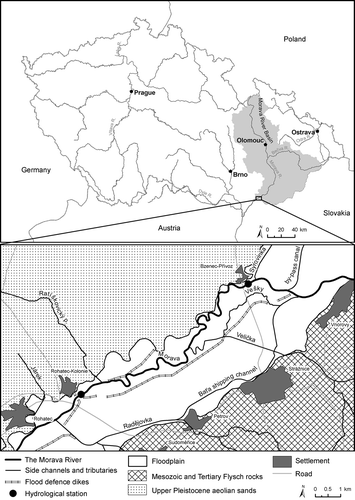
This work concentrates on the River Morava in the Strážnické Pomoraví region (southeastern Czech Republic) between Rohatec and Strážnice () as an example of a landscape influenced by human activity since prehistoric times. It assembles data on flood activity based on the findings of systematic hydrological measurements started in the second half of the 1880s, and evaluates their possible relationship with changes in the channel network. An evaluation of changes in the locations of water-gauge stations requires consideration in terms of changes in the river channel.
Fig. 1 The River Morava within the Strážnické Pomoraví region.
The following section of the paper characterizes the study site of the River Morava in the Strážnické Pomoraví area. The third section describes changes in the channel pattern based on available historical maps. Hydrological measurements in the studied area for the 1886–2010 period, and analysis of floods evaluated partly in terms of peak discharges and partly from peak water stages, as well as their chronology, are included in section four. The fifth and concluding sections evaluate the influence of channel changes in runoff patterns of the Morava floodplain and reveal possible links between flood records and channel changes.
2 STUDY SITE
The River Morava is the largest river in the eastern part of the Czech Republic. Above its confluence with the Danube, the Morava has a length of 353.1 km with a catchment area of 26 578 km2. The Dyje is its largest right-side tributary (catchment area 13 419 km2) and the Bečva is the largest left-side tributary (1626 km2). The study site is located on the section of the River Morava between Strážnice, Bzenec-Přívoz and Rohatec (known as the Strážnické Pomoraví region); the watercourse may be classified as a meandering lowland river ().
The Morava River rises on the southwestern slope of Králický Sněžník Mt at an altitude of 1380 m, and over the first 8 km falls to 550 m. The greatest part of the watercourse is located in the Hornomoravský and Dolnomoravský úval Basin (altitude between 150–250 m). The altitude influences climatic patterns: mean annual air temperature rises from 3–4°C at the source of the Morava to ∼10°C in the Strážnické Pomoraví region, while mean annual precipitation totals decrease from more than 1000 mm to 450–550 mm, respectively (Tolasz et al. Citation2007).
The length of the River Morava upstream of the Strážnice station is 218.8 km and the catchment area covers 9147 km2 (i.e. 34.4% of the whole Morava catchment). Recent land-use in the Morava catchment above the confluence with the Dyje is represented mainly by arable land (41.5%) and forest (37.3%), with some permanent grassland (11.5%) and built-up areas (7.4%). None of the other land-use categories (orchard; vineyard and hop-garden; water area; recreational area; other area) exceeds 1% of the Morava catchment in extent (Brázdil et al. Citation2011).
The channel network in Strážnické Pomoraví is represented by the following elements ():
| none | the River Morava—meandering, laterally-active main river channel of the floodplain; | ||||
| none | the Baťa shipping channel—arising out of the straightening and canalization of the anabranching Morávka channel; | ||||
| none | channels of tributaries of the River Morava (e.g. the Velička stream); | ||||
| none | fragments of a former network of smaller anabranching channels, which are currently mostly discontinuous or canalized (e.g. the Vešky stream); and | ||||
| none | a dense network of artificial drainage ditches. | ||||
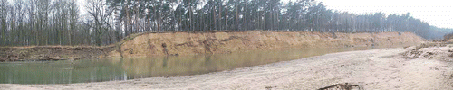
The River Morava transports a mixed sediment load, with sandy gravels at the channel bed and cohesive silts forming the banks. The fine-grained sediment fraction (silt and clay) is not deposited in the channel bed and only accumulates in the floodplain during overbank flows. In the upper part of the study site at Bzenec–Přívoz, the river is eroding late Pleistocene sandy sediments of the “Moravian Sahara”. Sand dunes exposed locally by lateral erosion form unstable bank slopes more than 10 m high in places (). The channel is surrounded by stands of deciduous forest with oak and many introduced species of fast-growing trees, pine monocultures, areas of arable land and, to a lesser extent, by grassland. Selected characteristics of the River Morava channel and floodplain are shown in .
Table 1 Morphometric characteristics of the River Morava channel in the section between the road bridge at Bzenec-Přívoz and the road bridge at Rohatec
Fig. 2 Eroding bank of the River Morava in the downstream part of the meander loop in the Osypané břehy locality. Bank erosion has exposed sediments of the sand dunes of the “Moravian Sahara”. The bank to the left of the aeolian sands was created by loamy alluvial deposits (photo by L. Krejčí, January 2008).
The channel network of the section of the River Morava floodplain under study may be generally characterized as strongly altered by human activity. Direct anthropogenic transformations of the river network have included channel straightening, fortification of banks with riprap, changes in cross-section, stream shifting, moving the positions of stream mouths, neglect of certain streams and building a network of artificial drainage ditches. More indirect have been basic influences on the dynamics of fluvial (hydrological and geomorphological) processes in the main Morava channel and its floodplain. Today, the bed of the main Morava channel is incised 6 m below the floodplain surface on average. Locally it is incised down to the sandy gravels that underlay fine-grained overbank deposits dated to the early and middle Holocene (Kadlec et al. Citation2009, Grygar et al. Citation2010).
The study of floods in the Strážnické Pomoraví region over the past 130 years requires that changes in the primary influencing factors, such as land use, climate and civil engineering, has to be taken into consideration. Changes in land use in the Morava catchment above the Dyje tributary have been characterized by Brázdil et al. (Citation2011) in terms of four time spans: 1836–1841 (standard agriculture), 1952–1956 (“socialist collectivization” of agriculture), 1988–1995 (change of political system) and 2002–2006 (free market economy). The whole period has been characterized by a continuously increasing proportion of forested area (from 28.4 to 37.3%). Arable land extent rose to a maximum in the 1950s (52.6%), when the lowest proportion of permanent grassland also prevailed (only 8.3% compared to 21.3% in 1836–1841).
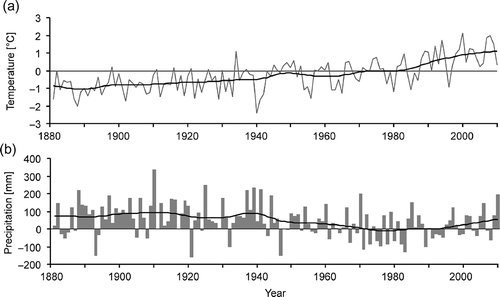
Climate variability over the past 130 years can be documented by homogeneous temperature and precipitation series from Brno. Annual mean temperatures show a generally increasing tendency over the last three decades (), culminating in the early 2000s. Fluctuations in annual precipitation totals reflect a wet period up to the 1930s–1940s and slightly dryer patterns afterwards, interrupted only by a small increase in precipitation in the 2000s.
Fig. 3 Fluctuations of anomalies of: (a) annual mean temperatures and (b) annual precipitation totals of the Brno station, 1881–2010. Smoothed by Gaussian filter over 30 years; horizontal lines express corresponding means of the reference period 1961–1990.
Civil engineering work on the River Morava itself consists of weirs, although reservoirs have been built on its tributaries as flood protection tools (four reservoirs in the 1920s–1930s) and for water supply (seven reservoirs in the 1960s–1970s). Of 12 reservoirs, the three with the greatest volumes were completed in 1976 (Slušovice Reservoir on the River Dřevnice—volume 9.95 × 10⁶ m3), 1972 and 1985. They represent 46% of the total holding capacity of all the reservoirs, which is 53.67 × 10⁶ m3 (Broža et al. Citation2005).
3 CHANGES IN THE CHANNEL NETWORK OF THE STRÁŽNICKÉ POMORAVÍ REGION IN HISTORICAL MAPS
3.1 Cartographical data
Long-term changes in the drainage network of the section of the River Morava floodplain under study are recorded on maps of the Third Austrian Military Survey (TAMS) from 1876 (scale: 1:25 000), Czech military topographic maps from 1932 (1:75 000), 1953–1955, 1987 and 1991 (1:25 000), and also on aerial images taken in 1938, 1953, 1981 and 2008 (1:5000). One limitation of these maps is that only planimetric changes in the channel network can be evaluated (see e.g. Hooke and Redmond Citation1989). No information is available about changes in channel cross-sections and longitudinal profiles. The scale of the maps has not allowed assessment of smaller in-channel features, such as riffles, pools, bars and small islands. Thus, certain changes in characteristics that influence hydraulic properties and flow in the channels could not be assessed thoroughly.
Studies of historical channel changes of the River Morava based on the analysis of historical maps are almost entirely lacking. The papers by Pišút (Citation2006a, Citation2006b) are the only exception: he reconstructed the development of the lower River Morava (Slovak–Austrian border) over the time period from 1896 to the beginning of river regulation (1951–1962), using historical cadastral maps (i.e. maps of land ownership). However, his work tends to concentrate on the derivation of bank erosion rates rather than on the reconstruction of overall changes in the channel pattern.
3.2 Changes in the channel network
3.2.1 3.2.1 Throughout the 19th century
Before the beginning of systematic hydrological observations, the River Morava functioned as an anabranching river system with two dominant channels (a northern and a southern arm). Both channels followed opposite margins of the floodplain and meandered considerably. It can be inferred from the high sinuosity and more intense branching of the northern arm that it conducted more flow than the southern arm. The northern arm continued to strengthen and dominate throughout the 19th century and prevailed completely by the mid-20th century. The two dominant anabranching arms were accompanied by numerous smaller perennial channels that transferred water between one another, or flowed parallel to one or other arm. These smaller channels were less sinuous, i.e. laterally more stable, than the dominant arms. The channel network also included an older generation of ephemeral and often discontinuous anabranching channels. Some of the latter were linked at one end to the active channel network, while others were disconnected from it. An anabranching channel pattern was also characteristic of the lower courses of the Morava tributaries, e.g. the Velička, in the first half of the 19th century. When systematic hydrological observations began in the 1880s, it is evident from contemporary maps that the northern arm had turned into the largest and most dynamic channel in the river system. The TAMS map ((a)) shows that some of the smaller anabranching channels were abandoned during the 19th century. Another important change was the origin of a large new avulsion channel in the lower course of the Morávka, which resulted in the separation of the available discharge into two channels. Hydrological observations began after the beginning of the transformation from an anabranching channel pattern to a single-channel river system. Nevertheless, dominant as well as secondary anabranching channels were still functioning and natural hydrogeomorphological processes were still operating within them. In the second part of the 19th century, the River Morava was an example of a laterally active, mixed-load (gravel bed and cohesive banks) anabranching system, classified as Type 3 according to the classification of Nanson and Knighton (Citation1996).
Fig. 4 Drainage system of the River Morava in the Strážnické Pomoraví region in: (a) 1882, (b) 1950, and (c) 2008 according to historical maps and aerial photos.

3.2.2 3.2.2 First part of the 20th century
Examination of the 1932 military topographic map reveals no notable changes in the course of the main Morava channel compared with TAMS maps. However, this could be the result of imperfect reproduction of the TAMS maps used in the creation of the military topographic map. The first three decades of the 20th century saw only minor changes in some of the anabranching channels. Progressive loss of flow and silting-up is notable on the Vešky channel. The new avulsion channel of the Morávka became dominant and the old, highly meandering channel lost its flow entirely during normal flow conditions ((b)).
The most dramatic changes in the river network and hydrological patterns of the Morava floodplain started in the 1930s (Zpravodaj Citation2005). What became known as the Baťa shipping channel, connecting Otrokovice and Rohatec, was built in 1934–1938. It was primarily intended to facilitate transport of lignite from the Lužice coal mine (downstream of the Strážnice area) to the Baťa factories in Otrokovice and Zlín (upstream). It was also to serve as a source of water for irrigation. The Baťa channel was built along much of the route of the Morávka, almost parallel to the Morava. The construction of the shipping channel resulted in substantial changes in the organization of the channel network in the adjacent part of the floodplain. The meanders of the Morávka were abandoned, its bed was straightened and the cross-profile resectioned (Karkošková Citation2010).
The channel was contained and aligned within low flood-defence dikes. Avulsion channels in the confluence area of the Morávka with the Morava were filled and flood defence dikes constructed. Connection of all the smaller anabranching channels to the Morávka (now the Baťa shipping channel) was seriously curtailed, resulting in reductions in their flow. The channels of some tributaries of the Morava and the Morávka were re-routed. The most marked changes occurred on the Velička, which originally led to the Morávka. A crossing with the Baťa shipping channel and a new section of channel were constructed and a new mouth to the Morava created. Some artificial adjustments were also made to the main channel of the River Morava. Most important among them was a straightening of certain channel reaches, as evident from maps of the post-construction period.
3.2.3 3.2.3 Second part of the 20th century and beginning of the 21st century
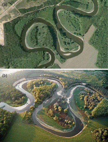
Maps from 1987 and 1991, coupled with aerial images taken after 2000, reveal a channel network similar to that of the 1950s. The most remarkable change may be seen in the continuing extension of drainage ditches ((c)). The process of abandoning the anabranching channels could be considered complete with the cessation of flow in the two remaining side channels within the confluence area of the Morava River and the Baťa shipping channel. Local lengthening of the main Morava channel is also evident, especially in the Osypané břehy (“Spilling Banks”) locality, which is particularly vulnerable to bank erosion in its sandy deposits (). Although two meanders at Osypané břehy may be traced back to the maps from the second half of the 19th century, acceleration of lateral erosion and lengthening of the channel began only after the 1940s. Straightening and re-sectioning of the channel downstream in the 1930s was the probable cause of enhanced lateral erosion in succeeding decades. The upstream meander was cut off naturally in spring 2006 (). A flood with a return period of 50 years at the end of March 2006 significantly contributed to this event, but it should be pointed out that this was merely the last stage of an acceleration of lateral erosion that had been observed there since the 1960s, at the very least (Kirchner et al. Citation1992). Judging by just the rate of lateral erosion, Kirchner et al. (Citation1992) predicted that cut-off would have occurred anyway around 2002. Geomorphological changes that probably occurred in the river channel and floodplain in response to the disastrous flood of July 1997 were not thoroughly documented.
Fig. 5 Aerial views of the Osypané břehy locality showing the channel of the River Morava in 2003 (a) and after channel shortening in 2006 (b). The inflow and outflow parts of the old meander bend filled up with fluvial sediments soon after the cut-off formed. Visible at (b) is a high bank scour in the left meander, created by erosion of sands shown in (photo by J. Wenzel).
3.3 Overall changes of channel pattern since the mid-19th century
What was once an extensive anabranching channel pattern has been heavily modified and now exists only in fragmentary form. The best-preserved part is the northern main channel of the former anabranching system (the River Morava), which conveys the largest portion of water through the floodplain. The southern main channel, the Morávka, which was modified to create a shipping channel, and the regulated channel of the Vešky, are the other remaining arms of the anabranching system. However, only the Morava proper maintains the natural dynamics of hydrogeomorphological processes. Its channel is laterally very active and the bank erosion rate reaches several metres a year.
The steady transformation from an anabranching to a single channel meandering system during the 19th century, can be traced on historical maps, but the cause of this change has yet to be explained in satisfactory fashion. The most probable driving factor was the introduction of routine river management practices, such as clearing channels of excessive sediments (sediment bars) and removal of large woody debris, intended to increase the conveyance of the channel and aid flood prevention. Further human intervention, which gathered pace during the 19th century, consisted of dredging gravel from the river bed for building purposes, some of it as material for the construction of railways (e.g. Horák Citation1911, Lorenc Citation1928, Semotanová Citation1998). These management procedures primarily involved the largest river branches, i.e. the northern and southern arms, and inevitably led to a decrease in hydraulic roughness and deficit of transported sediments. These mechanisms promoted acceleration of erosion, both incision and lateral in nature, leading to enlargement of the channel cross-profile. Greater channel capacity promotes the transfer of larger discharges through the anabranching system within a single channel during floods. Positive feedback then accelerates the process and increases the dominance of the single channel. Similar human-induced transformation from an anabranching to a single meandering river pattern was recorded in the upper course of the River Morava by Máčka and Kirchner (Citation2001). Thus, causes of channel pattern metamorphosis may be explained in terms of anthropogenic pressure on the river system rather than as a consequence of natural driving factors.
4 FLOOD SERIES OF THE ROHATEC/STRÁŽNICE STATIONS, 1886–2010
4.1 Hydrological data
Systematic hydrological observations on the River Morava in the Strážnické Pomoraví region started with water-gauge measurements at Rohatec in 1886 (for all the hydrological stations used in this study, see ). The records are preserved in the archives of the Czech Hydrometeorological Institute (CHMI), Brno branch, and in hydrographical yearbooks (Jahrbuch, Citation1895–1918). Initial records refer to measurements taken above and below the weir at the Rohatec mill. According to a contemporary drawing, the first water gauge was located about 20 m above the weir to the right of a garden. The second water gauge was below the weir, also to the right. Data are available for the “above-weir” water gauge from 1886 to 1911, and for the “below-weir” water gauge from 1889 to 1911. In general, they fail to cover all months of any given year. However, a further Rohatec station appeared in yearbooks after 1897, and, on 1 October 1908, a new station was established at the bridge. This station was in operation until it was closed on 31 May 1940. The construction of the Hodonín weir with its power station is mentioned as a possible argument for closing the station; the Rohatec station may well have become backwatered.
Table 2 List of hydrological stations used in this study and selected characteristics
The Rohatec water-gauge station was re-located in 1940 to the Strážnice road bridge, where a pipe water-gauge recorder was installed in 1943. In 1947, a brickwork station was built on the right bank of the River Morava, between this station and the ropeway (about 10 m downstream), which remained in operation until 1967. When the old bridge was demolished, a second pipe water-gauge recorder was installed on the temporary bridge; it operated between 1967 and 1972. While today's concrete bridge was under construction, the recorder returned temporarily to the brick station. Once the new bridge was complete, a third pipe water-gauge recorder was built on its right pier and remained in operation until 1991.
The Strážnice hydrological station is now located on the slope of the right bank of the Morava, ∼200 m upstream of the road bridge between Strážnice and Bzenec. The station is equipped with a FIEDLER system for automatic transmission of the water stages measured, and with vertical and oblique water gauges (Dostál et al. Citation2001).
Compilation of common flood series for the Rohatec and Strážnice stations on the River Morava is based on peak discharges and peak water stages of the two stations.
4.2 Peak discharges and floods, 1921–2010
A continuous series of annual peak discharges for the Strážnice station is available in CHMI documents for 1921 onwards. However, in the first part of the series, up to May 1940, the discharges were evaluated for the Rohatec station on the railway bridge and only subsequently for the Strážnice station. Considering the relative proximity of the two stations (about 12 km), and the fact that in this section of river the Morava has no significant tributaries, differences in peak discharges may be considered to be negligible.
shows fluctuations in annual peak discharges for the River Morava at Rohatec/Strážnice in the 1921–2010 period. They are classified in terms of occurrence in the winter (November–April) and summer (May–October) hydrological half-years, after Kakos (Citation1983). A sudden melting of accumulated snow reserves, mainly in mountainous parts of the catchment area, often accompanied by rainfall, is important for the generation of winter floods between November and April. Heavy rains, lasting for several days, cause summer floods between May and October. The values of annual peak discharges, Qa , are further compared to peak discharges with an N-year return period (QN ), as follows (in m3 s1): Q 2: 440, Q 5: 525, Q 10: 588, Q 20: 649, Q 50: 730, Q 100: 790. So far the highest peak discharge at Strážnice, a flow of 901 m3 s1, was recorded on 10 July 1997, during the “flood of the 20th century” on the River Morava (see e.g. Soukalová et al. Citation1997, Matějíček Citation1998, Matějíček and Hladný Citation1999, Dostál et al. Citation2002) and significantly exceeded the value of Q 100. This discharge was partly related to the breaching of a railway embankment that had held back a large mass of water. The non-enhanced discharge reached 810 m3 s1 on 14 July. The second highest peak discharge, 754 m3 s1, was during the flood on 2 June 2010, and corresponded to Q 50, as did the third-highest peak discharge of 733 m3 s1 during the flood on 29 March 2006 (for the March 2006 flood, see e.g. Brázdil and Kirchner Citation2007). During 90 years of observations, the annual peak discharge was ≥Q 2 in 39 years (i.e. 43.3% of all years) with an accumulation of these cases evident between 1937 and 1987 (see ).
Fig. 6 Annual peak discharges of the River Morava for the Rohatec/Strážnice stations in the 1921–2010 period with respect to their occurrence in the winter (November–April) and summer (May–October) hydrological half-years. A variety of discharge return frequency levels (from Q 2 to Q 100) are indicated.
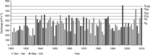
In terms of seasons, the occurrence of annual peak discharges exhibits a dominant concentration in the month of March (31.1%). Frequencies for February (12.2%) and January (11.1%) are much lower. Smaller percentages of the annual peak discharges occurred in June (10%), and in April and July (8.9%). In the 1921–2010 period, the annual peak discharge never occurred in November.
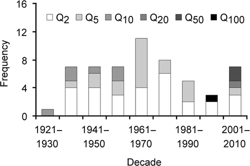
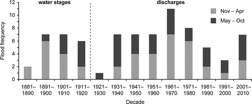
Further, only peak discharges which exceeded the two-year peak discharge, Q 2, were considered. Altogether 56 floods were recorded on the River Morava at Rohatec/Strážnice in the 1921–2010 period; their particular occurrence in individual decades was variable (). Eleven floods occurred in 1961–1970, while further decades between 1931 and 1980, and 2001–2010 yielded seven to eight floods. Only one flood occurred in the 1921–1930 decade and three in 1991–2000. The remaining 1981–1990 decade had five floods. With respect to 1931–1980, the subsequent two decades (1981–2000) showed a significant reduction in the number of floods. Yet, the three most severe events were recorded in the two most recent decades. As 56 floods occurred in only 39 years (an average of 1.4 floods per year), more than one flood event was recorded in several individual years. Three floods in a year occurred in 1940, 1962 and 1974; two floods per year were recorded in 11 years.
Fig. 7 Decadal frequencies of the occurrence of floods above the two-year peak discharge (≥Q 2 according to their N-year return period on the River Morava for the Rohatec/Strážnice stations in the period 1921–2010.
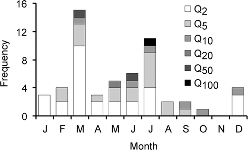
The annual distribution of floods with peak discharge ≥Q 2 in the 1921–2010 period () confirms the dominant occurrence of floods in March (26.8% of all floods), followed by July (19.6%) and, at a substantially larger interval, in June (10.7%); 8.9% of all floods were recorded in May, followed by February and December (7.1% each). The proportion of winter floods is slightly higher than summer ones (51.8 vs 48.2%).
Fig. 8 Annual variation of frequencies of flood occurrence with above two-year discharge (≥Q 2) according to their N-year return period for the River Morava at the Rohatec/Strážnice stations in the period 1921–2010.
4.3 Peak water stages and floods, 1886–1920
The following series of measured water stages from Rohatec are available:
| a. | Rohatec, above weir, 1886–1911. | ||||
| b. | Rohatec, below weir, 1889–1911. | ||||
| c. | Rohatec, railway bridge, 1897–1940, with changes in water-gauge position in 1908, 1921 and twice in 1937. | ||||
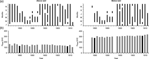
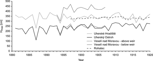
shows fluctuations in annual peak water stage of the River Morava for the earliest measurements at the Rohatec weir. It also reveals that, for the greater part of the period analysed, observations were not provided for the whole year; such incomplete records missed the annual peak water stages in 1890, 1898 and 1909, which are known from nearby stations. The question remains as to what extent the measured water stages were influenced by operation of the weir, and/or by the lower quality of observations evident in the records from December 1905 onwards. While a slight increasing trend in the peak levels was recorded in 1899–1911 on the water gauge located below the weir, the water gauge above the weir showed an apparent decrease for these years. This indicates possible changes in the Morava channel profile at the Rohatec weir related to accumulation and erosion processes.
Fig. 9 (a) Period of measurements during the year, and (b) annual peak water stages H max at the Rohatec above-weir (1886–1911) and Rohatec below-weir (1889–1911) stations. Black columns indicate highest peak water stage for years in which incomplete series exist, i.e. these do not necessarily correspond to highest annual peak water stage in equivalent years.
At Rohatec, during the period 1886–1920, the majority of annual peak water stages occurred during the months of the winter half-year. Annual peak water stages occurred most frequently in March (30.9%), followed by January and February (11.8% each) and April (10.3%). Surprisingly, no annual peak water stage occurred in July. A smaller share of peak values in summer, evaluated from water stages, is the main difference with respect to those values derived from discharges after 1921.
Water stage measurements at Rohatec were re-calculated in the light of knowledge of the water-gauge base-level, to the 1897 base-level (1897–1908, altitude 163.42 m; 1909–1920, altitude 163.35 m; 1921–1936, altitude 163.26 m; 1937–1940, altitude 163.29 m). This enabled the compilation of a series of annual peak water stages for the whole sequence up to 1940. If only the part of the series before 1920 () is considered, the highest water stage, 350 cm, occurred on 10–11 September 1910 and 24 May 1911. The second-highest water stage, 347 cm, was recorded four times in three consecutive years: 23–24 March 1906, 20–22 January 1907, 21–25 March 1907 and 10–11 May 1908. Variations in annual peak water stages at Rohatec may be considered together with the upstream stations of Veselí nad Moravou, Uherský Ostroh and Uherské Hradiště (). To evaluate severity, series of peak water stages for Rohatec (1897–1936), Uherské Hradiště and Uherský Ostroh (1881–1920) were fitted by the three-parameter generalized extreme value distribution (distribution parameters estimated by the maximum likelihood method; Katz et al. Citation2002) and the corresponding peak water stages with N-year return period were calculated. Peak water stages ≥H 2 at these stations were then compared to give estimates of the relative importance of floods that took place in the Strážnické Pomoraví region. The floods in the years 1886, 1888, 1891, 1892, 1893, 1895, 1897 (two), 1900, 1901, 1903, 1906, 1907, 1908, 1909, 1910, 1911, 1913, 1915, 1917, 1919 and 1920 may be considered the most important in these terms.
Fig. 10 Fluctuations in relative annual peak water stages of the River Morava at the upstream stations of Rohatec, Uherské Hradiště, Uherský Ostroh and Veselí nad Moravou (above/below weir) for the 1881–1920 period (for stations see ).
4.4 Synthesis of floods
A continuous flood chronology for the River Morava at the Rohatec/Strážnice stations over the 1886–2010 period was created based on peak water stages (Hk ≥ H 2; Rohatec 1886–1920) and peak discharges (Qk ≥ Q 2; Rohatec 1921–1939, Strážnice 1940–2010). The series was extended back to 1881–1885 using annual peak water stages (Hk ≥ H 2) measured at the nearby stations of Uherský Ostroh and Uherské Hradiště, but no other flood occurred in this five-year period (). The highest frequency of floods (seven or more floods per decade) was recorded in the periods 1891–1910, 1931–1980 and 2001–2010, with a clear predominance in the 1961–1970 decade, with 11 floods. In contrast, only one flood was recorded in 1921–1930, two occurred in 1881–1890 and three in 1991–2000. There is a higher proportion of winter floods as compared to summer floods (55.1% cf. 44.9%) among the 78 floods in this compiled series, with summer floods prevailing in the years 1911–1940 and 1981–2010.
Fig. 11 Synthesis series of decadal frequencies of floods of the River Morava at the Rohatec/Strážnice stations in the 1881–2010 period with respect to their occurrence in the winter (November–April) and summer (May–October) hydrological half-years. Flood frequencies were derived from annual peak water stages (Hk ≥ H 2) of Uherský Brod and Uherské Hradiště (1881–1885), peak water stages (Hk ≥ H 2) of Rohatec (1886–1920) and peak discharges (Q k ≥ Q 2) of Rohatec (1921–1939) and Strážnice (1940–2010).
The above criteria (Hk ≥ H 2 and Qk ≥ Q 2) used for the development of the synthesized flood chronology may well be too rigorous for the study of depositional sediments. More precisely, according to information relating to 1920 (Hydrologická zpráva, 1925), bankfull discharge (i.e. conditions for the deposition of sediments) of the River Morava at the Rohatec station corresponded to a water stage of 310 cm. Although the precise changes in channel cross-section are unknown, if one relates this information to the series from 1897 it would mean that river water inundated the floodplain nearly every year, or even twice a year (e.g. 1907, 1917, 1925, 1927 and 1932). Only in 1912 and 1936 was the peak annual water stage below 310 cm. This implies that sedimentation in the river floodplain may have been relatively continuous and undisturbed before its modification and regulation, which is an important presumption in the use of floodplain sediments as a palaeo-environmental archive in the Strážnické Pomoraví area (see also Kadlec et al. Citation2009, Grygar et al. Citation2010).
In the more recent profile at Strážnice station (1991 onwards), the overbank discharge of the River Morava channel occurred at discharges greater than ∼520 m3 s1, which corresponds to a discharge with a return frequency of 5 years, Q 5 (525 m3 s1). For instance, the overbank discharge figure of 520 m3 s1 has been exceeded in only five years since 1991. Despite the absence of knowledge of changes in the Morava channel cross-section, we can assume that a similar situation also existed between 1940 and 1990. The inundation frequency of the floodplain after regulation works has decreased and, therefore, no longer occurs more or less annually, as it did before regulation. Moreover, Q 2 floods probably did not inundate the floodplain.
5 DISCUSSION
Changes in the channel network have undoubtedly been reflected in the transfer of flood discharges throughout the floodplain. Despite certain limitations inherent in historical maps (mainly due to lower planimetric accuracy), they reveal valuable information about changes in the river network, including natural geomorphological processes and human-related alterations. Progressive filling of oxbow lakes and their transformation into forested wetlands may be taken as an example of natural development. From visual analysis of historical maps it follows that, in the 18th and 19th centuries, the River Morava took the form of an anabranching river system with one slightly dominant channel and an accompanying network of parallel and transverse channels of various dimensions. Some anabranching channels were sinuous and laterally active, while others were straight and laterally stable. Maps made in the 19th century also show the remnants of an older generation of degrading channels disconnected from the channel network. This suggests the dynamic character of an anabranching system in which avulsion channels were constantly changing between states of formation and inactivation. It is possible that the anabranching system has been affected by deliberate artificial interventions in much the same way as has been reported for a lowland river in eastern Germany (Herget Citation2000) and the River Morava upstream of Olomouc (Kirchner et al. Citation2000). Historical maps do not show any new avulsions since the mid-19th century, which suggests a weakening of the anabranching system and transition towards a system with one dominant channel.
Older inactive channels probably only carried a flow during flood events. The distribution of inundated areas during floods with overbank flow was closely related to the spatial pattern of the anabranching channels. The channels were narrower and shallower, with lower discharge capacities, when compared to more recent channels. Their discharge capacity was further decreased by obstacles; fallen trees are notable examples, since the channels mainly flowed thorough floodplain forest. The existence of an anabranching channel pattern shows up in the hydrological regime in the form of more frequent fluctuations of water stage (floods) and in the lower discharge capacity of channels (Nanson and Knighton Citation1996). Such channels may be detected through analysis of floodplain sediments by means of, for example, sand and sand-silt deposits in palaeochannels (Werritty et al. Citation2006). These originally incised into finer clay-silt alluvial deposits, rather than into the sandy gravels of the pre-Holocene and early-Holocene base of the recent floodplain alluvial deposits. Such channels can be recognized in the exposed sections of eroded river banks along the River Morava. Two such channels, dated by 14C to mediaeval times, have been found in the northern part of the study territory, and are about 2 m deep and 10 m wide (Grygar et al. Citation2010; today's channel is much larger, see ). In terms of earlier runoff, this means that:
| a. | The total discharge of water through the floodplain before the 20th century was divided into several smaller anabranching channels. In the present day, almost the entire flow is concentrated into one meandering channel. | ||||
| b. | Some of the anabranching channels were meandering, i.e. the total path of water flow through the floodplain was longer than it is today. | ||||
| c. | Water flow through the floodplain was generally slower because of roughness elements within the beds and banks of the channels (channel bars, large woody debris), and the channel curvature of meandering reaches. | ||||
| d. | Floodplain inundation was more frequent, and a large part of runoff during floods routed itself through the floodplain, away from river channels. | ||||
| e. | The floodplain contained more roughness elements and retention areas—woody vegetation (floodplain forest), abandoned anabranching channels, oxbow lakes, shallow surface depressions. | ||||
| f. | Thus, more flood waters infiltrated into shallow Upper Pleistocene and Holocene aquifers. | ||||
The state of the channel structure was probably reflected in a slower passage of floods through the floodplain, flatter flood waves and milder recession phases due to slower emptying of surface retention areas and longer periods of outflow of groundwater from alluvial sediments. Progressive concentration of runoff into a smaller number of runoff channels (today only the River Morava and the Baťa shipping channel) and shortening (straightening) of the remaining runoff channels was typical of the 19th century and, in particular, the 20th century. Consecutive runoff concentration inevitably leads to increases in discharge capacity for the remaining channels and acceleration of runoff. Today, a relatively dense network of drainage ditches also facilitates faster draining of the floodplain during flood events. In addition to the fact that an important decrease in flood frequency occurred only in 1981–2000, the frequency of overbank flows and floodplain inundation decreased considerably in the second part of the 20th century. The reason for this lies in the progressive enlargement of the channel cross-section arising out of incision and bank instability, so facilitating the conveyance of ever larger discharges within the channel. In the inundated part of the floodplain, i.e. only within flood dikes, rather coarser sediments are deposited in comparison to the state before regulation work (Grygar et al. Citation2010).
Based on historical maps, the first period of significant changes to the Morava floodplain began just before 1840, when certain lateral channels of the Morava were abandoned and the course of the downstream reach of the Morávka changed. The sediment record shows that this process actually started much earlier than is apparent from the maps (Kadlec et al. Citation2009, Grygar et al. Citation2010). The neglect continued until the second part of the 19th century and the beginning of the 20th century. The cessation of flow in the older, meandering channel of the Morávka lower stream can be taken as an example. The most dramatic changes occurred in the 1930s, arising out of re-building of the Morávka channel to accommodate shipping (straightening its course, modification of its cross-section), partial straightening of the Morava channel, a change in the outlet of the Velička from the Morávka to the Morava River and the completion of the system of flood defence dikes. The accelerated incision of the Morava channel and corresponding increase of its discharge capacity was initiated by these interventions. The channel cross-sections from the period contiguous with the regulation works are not available. However, comparison of the medieval palaeochannels to the present-day channel reveals marked channel enlargement.
Development of the River Morava floodplain in the Strážnické Pomoraví region is a result of both natural (e.g. climatological, hydrological, geomorphological) and anthropogenic factors. This paper concentrates mainly on systematically observed floods and changes in channel network with reference to historical maps. Although the flood series based on systematic observations cover only the period since 1881, in terms of channel changes they provide important knowledge for the evaluation of sedimentation in the floodplain (Kadlec et al. Citation2009, Grygar et al. Citation2010). It may be concluded that, before the dramatic anthropogenic modifications to the floodplain in the 1930s and later, inundation of the floodplain was an almost annual phenomenon, often occurring more than once a year (the proportional frequencies of winter to summer floods being to a large extent comparable). The decreasing frequency and extent of floodplain inundation in recent decades can be related to changes in the organization of the drainage network rather than to climate forcing. The reason probably lies in the conversion of the anabranching system of lower-capacity channels into a single, large meandering channel. The degradation of the anabranching system may be traced on historical maps through the 19th and 20th centuries, especially after river regulation works in the 1930s. The modern river channel has the capacity to conduct discharge almost equivalent to that of a five-year flood (Q 5), in contrast to the situation before the 1930s when there were floodplain inundations every year. This is the result of channel instability and channel enlargement in response to river regulation works in the last 80 years.
Studies assessing the role of human-induced channel pattern changes in flood conveyance and dispersal of suspended sediment over floodplains are somewhat rare in Europe. Similar changes in the relationship between flood conveyance and channel morphology, but in the opposite direction, were recorded on the lower Missouri by Pinter and Heine (Citation2005). They encountered a rise in flood stages (water levels) for the same discharges from the beginning of the 20th century. The changes were due to flow velocity reduction and channel constriction created by deliberate human intervention. We found an opposite pattern of change, in which flood stages decreased considerably for the same discharges in the second half of the 20th century. A somewhat similar development in terms of channel pattern metamorphosis was reviewed by Surian and Rinaldi (Citation2003) with reference to several Italian rivers. In that case, river engineering work lay behind a channel adjustment, leading to change from a braided pattern to a meandering one. Association of human-induced channel changes and flood hydrographs was also studied by Wyzga (Citation1993) along the River Raba in Poland. He reported downstream magnification of flood discharges and an increase in the flashy nature of floods resulting from incision and backward erosion consequent on artificial narrowing and straightening of the channel. A similar pattern of channel change in an anastomosing-meandering river in the pre-regulation period (18th to later 19th century) was described on the River Danube near the City of Bratislava (Slovakia) by Pišút (Citation2002). Just as on the River Morava, channel changes consisted of avulsions through channel switching into chute channels, meander development through progression and cut-offs, and abandonment of secondary channels. This dynamic behaviour was later inhibited by regulation engineering.
The origins of floods lie in the consequences of the combination of certain extreme hydrological and meteorological patterns that may vary widely in terms of space. This is also reflected in the seasonality of floods. For example, Beurton and Thieken (Citation2009) divided flood regimes in Germany into three groups: (i) western and central parts with winter floods; (ii) northern and eastern parts with a higher proportion of spring and summer floods than in the previous group; and (iii) the southern part, where summer floods predominate. Parajka et al. (Citation2009) studied the seasonality of selected hydrological characteristics in Austria and Slovakia, which they consider as an important indicator of flood processes varying considerably in space. Varying seasonality for various rivers leads to differences in flood frequency and severity, even in neighbouring catchments. For example, while the River Morava is characterized by a comparatively equal frequency of winter and summer floods, at the Bohumín station on the River Odra (located northeast of the Morava catchment), winter floods occurred only three times out of a total of 43 recorded events in 1896–2003. In contrast, the River Vltava in Prague showed a clear prevalence of winter floods (37) over summer floods (25) in 1881–2000 (Brázdil et al. Citation2005).
These results have a significant influence on comparisons of decadal flood frequency between different rivers. For example, based on 20th-century discharge data, the River Svratka (a tributary of the Dyje) in Brno exhibited maximum flood frequency in the 1920s and 1940s, while this occurred on the River Svitava (a tributary of the Svratka) in the 1930s and 1960s (Brázdil et al. Citation2010). Of the two most important tributaries of the Morava, the Bečva (at the Teplice nad Bečvou station) showed the highest flood frequency in the 1930s and 1900s–1910s, while the Dyje (at Travní Dvůr) did so between 1921 and 1950, with the highest frequency in the 1930s. On the River Odra (at Bohumín), floods occurred most frequently in the same decades as on the Bečva (Brázdil and Kirchner Citation2007). Floods on the rivers of Lower Silesia (Poland) were most frequent in 1881–1910 and 2001–2010, while their secondary peak in 1921–1940 was much lower (Kasprzak Citation2010). In Bohemia, the River Vltava in Prague and the River Elbe at Děčín reached maxima in the 1940s, but only one flood was recorded in the 1960s (Brázdil et al. Citation2005). The highest flood frequency on the above rivers in the 1930s and 1940s agrees well with the chronology of those on the River Morava (Rohatec/Strážnice), where frequent floods occurred between 1931 and 1980. But the maximum frequency in 1961–1970 (see ) shows little agreement with the above rivers. Taking into account the higher frequency of the Morava floods based on water stages in 1891–1920, this is confirmed not only by the Bečva and Odra in Moravia (Brázdil and Kirchner Citation2007) and rivers of Lower Silesia in Poland (Kasprzak Citation2010), but also by the Vltava and the Elbe for 1891–1900 in Bohemia (Brázdil et al. Citation2005).
With respect to the seasonality of Morava floods, March events, followed by January and February events, dominate in series derived from annual peak water stages or annual peak discharges. This is in partial agreement with the situation in neighbouring northern Austria and western Slovakia, where annual maximum floods (1961–2000) have been recorded most frequently in March, and April (Parajka et al. Citation2009). A maximum frequency of floods during March for Morava floods also occurs in 1921–2010, but followed by July, and then June. This confirms the importance of heavy precipitation events in the generation of summer floods in the area studied. Parajka et al. (Citation2009) identified June and July as the months with the most frequent large floods.
The frequencies of winter and summer floods differ only slightly in individual decades (). One exception is the highest occurrence of winter floods in 1891–1900 and 1961–1980, with definite prevalence compared to the frequency of summer floods. The opposite occurred clearly in 1931–1940, and partly in 1911–1920. Seven of the 13 decades analysed had a higher number of winter floods than summer ones (1881–1910, 1941–1980), while in 1911–1940 and 1981–2010 the opposite held true. These results do not indicate any significant change in the occurrence of flood events during the winter and summer hydrological half-years.
Working on any synthesized flood chronology requires an awareness of possible uncertainties; these are largely associated with floods derived from water stages before 1921. Because individual floods at Rohatec were selected according to the Hk ≥ H 2 relationship, derived from the three-parameter generalized extreme value distribution (Katz et al. Citation2002) and cross-checked by data from Uherský Brod and Uherské Hradiště (analysed in the same way), the flood frequencies obtained appear to be reliable. Using these two stations introduces no additional uncertainty into frequencies, because the River Morava has no important tributary influencing its discharges between Rohatec and Uherské Hradiště (see also ). Moreover, the floods we selected for before 1921 are supported by flood data from southeastern Moravia gathered from documentary evidence (such as newspapers, chronicles and economic records) that are related to events with overbank flow and inundation of the floodplain (for more details, see Brázdil et al. Citation2006, Citation2011). However, it is difficult to evaluate the severity of floods from measured water stages (before 1921), because calculation of discharges applying hydraulic equations would be significantly biased by the unknown cross-section of the channel. For this reason, the severity of the Morava floods was studied only for the 1921–2010 period of discharge measurement (see and ).
The three most severe known floods on the River Morava were recorded since 1990 (July 1997 with Q 100, March 2006 and June 2010 with Q 50). While the flooding in 1997 and 2010 was related to heavy precipitation episodes caused by a Mediterranean cyclone moving along the van Bebber pathway (“Zugstrasse Vb”) (see e.g. van Bebber Citation1881, Citation1883, Štekl et al. Citation2001, Mudelsee et al. Citation2004, Pánek et al. Citation2011), the 2006 flood was related to rapid melting of deep snow cover (Pinto et al. Citation2007) in combination with rain. Such flood events may be responsible for the delivery of large quantities of fine sediment to the floodplain surface, and channel changes similar to a meander cut-off that took place in the Osypané břehy locality during the 2006 flood (see ). Even the 2006 rupture of a meander only completed a process of accelerated lateral erosion initiated by channel straightening several hundred metres downstream of the locality in the 1930s. Lateral erosion at Osypané břehy also accelerated during the 1960s (also reported by Kirchner et al. Citation1992), which corresponds with the highest recorded frequency of floods (see ). The maximum frequency of floods in 1961–1980 can be related to the most significant changes in land use associated with the process of “socialist collectivization” in agriculture. An increase in the area of arable land and reduction in permanent grassland significantly decreased the retention capacity of the landscape in the River Morava catchment (Skokanová Citation2009, Brázdil et al. Citation2011).
6 CONCLUSION
Analysis of the hydrological and geomorphological regimes of the River Morava over the last 130 years discloses a dynamic fluvial system that has been predominantly governed by direct, as well as indirect, human interventions since the first half of the 20th century. Direct anthropogenic influences entirely masked the underlying natural evolutionary tendencies in the period preceding the Second World War. The following period was characterized by morphological and hydrological adjustment to previous river engineering work and by transition towards a new state of dynamic equilibrium. Historical analysis of floods and morphological changes in the channel network appear to be a convenient tool for evaluation of temporal changes in the ecological status of rivers in accordance with European Water Framework Directive (Directive 2000/60/EC, European Parliament and Council Citation2000). Hydromorphological quality is also being assessed alongside investigation of biological and physico-chemical quality elements. However, sufficient assessment of hydromorphological quality requires an adequate reference framework; ideally, this would include knowledge of the state of the water bodies in the period preceding their direct human modification. Hydrological regime, river continuity and morphological conditions are components of hydromorphological quality assessment. Historical maps may be a valuable source of information on river continuity and morphological conditions. Moreover, our paper shows that analysis of historical archival resources (records of hydrological observations and measurements) may supply valuable information for the reconstruction of reference hydrological conditions. The example of the River Morava also shows how coupling between changes in river channel morphology and changes of hydrological regime may take place.
This paper is a contribution to the study of the hydrological variability of the most important river in the eastern part of the Czech Republic, to which far less attention has been devoted than to other Czech Rivers (see e.g. Brázdil et al. Citation2005, for overview). By means of the analysis of historical maps, it documents the change of an anabranching channel pattern of the River Morava to a meandering system with a single channel, a process that mainly took place between the 1850s and 1930s. A natural process of channel pattern metamorphosis, that usually takes decades, was significantly accelerated and finalized by river regulation works during the 1930s. Immediately afterwards, enlargement of the single meandering channel became considerably accentuated. The cross-section of the dominant meandering channel doubled (at the least) in the course of the last 80 years, considerably lowering the frequency of floodplain inundation. Before regulation the inundation of the floodplain was nearly an annual phenomenon (often more than one overbank flood in a year), increasing channel capacity after regulation had lowered the re-occurrence interval of floodplain inundations to around the five-year discharge (Q 5) figure. Changes of overall channel pattern, as well as changes in channel morphology (bedforms, cross-section), may affect the frequency and extent of floodplain inundation and thus formation of alluvial archives.
Studies devoted to historical changes in fluvial systems are targeted mainly on relationships between floodplain sedimentation, climatic change, land-use change and slope soil erosion in a European context (e.g. Rumsby and Macklin Citation1996, Starkel Citation2002, de Moor and Verstraeten Citation2008). Most of these studies are based on investigations of alluvial and colluvial sedimentary archives. As may be seen in the review papers by Dotterweich (Citation2008) and Notebaert and Verstraeten (2010), such studies are virtually absent from the Czech Republic and Slovakia. In our study, we adopted a slightly different approach, focusing on the possible impact of channel pattern change on the hydrological regime and flood conveyance within a section of a floodplain. Our study shows that the climatic and land-use signals in alluvial sediments may easily be obscured by human-induced changes to the channel network in the most recent period (the last 200 years).
It follows from the above analysis that we are dealing with a very complicated system, in which further research and consideration of other effects (land-use and climate change), discussed in more detail in a further paper by Brázdil et al. (Citation2011), may contribute to a better understanding of the interrelationships between floods, human impacts (e.g. channel modifications, land-use changes) and floodplain development. However, floodplain development itself is an important factor in the study of floods and their long-term impacts.
Acknowledgements
This paper was prepared with the financial support of grant no. IAAX00130801 from the Grant Agency of the Academy of Sciences of the Czech Republic “Interrelationships among climate, anthropogenic activity and landscape erosion recorded in natural archives of the Strážnické Pomoraví (Czech Republic)”. We would also like to thank Tony Long (Svinošice) for English style corrections, Denis Coeur (Biviers, France) for the French translation, Lukáš Krejčí (Masaryk University, Brno) for help with computer graphics and for the use of the photograph, and Jiří Wenzel (Union for the River Morava) for the opportunity to use his photograph of the study area. The two anonymous reviewers are acknowledged for their constructive comments and proposed improvements to this article.
Related Research Data
REFERENCES
- Asselman , N.E.M. , Middelkoop , H. and van Dijk , P.M. 2003 . The impact of changes in climate and land use on soil erosion, transport and deposition of suspended sediment in the River Rhine . Hydrological Processes , 17 ( 16 ) : 3225 – 3244 .
- Bebber and van , W.J. 1881 . Die geographische Vertheilung und Bewegung, das Entstehen und Verschwinden der barometrischen Minima in den Jahren 1876 bis 1880 . Zeitschrift der Österreichischen Gesellschaft für Meteorologie , 16 : 414 – 419 .
- van , Bebber, J. 1883 . Typische Witterungserscheinungen . Zeitschrift der Österreichischen Gesellschaft für Meteorologie , 18 : 447 – 458 .
- Benito , G. 2010 . The impact of late Holocene climatic variability and land use change on the flood hydrology of the Guadalentín River, southeast Spain . Global and Planetary Change , 70 ( 1–4 ) : 53 – 63 .
- Beurton , S. and Thieken , A.H. 2009 . Seasonality of floods in Germany . Hydrological Sciences Journal , 54 ( 1 ) : 62 – 76 .
- Brázdil , R. 2005 . Historické a současné povodně v České republice (Historical and recent floods in the Czech Republic) , Brno, Praha : Masarykova univerzita, Český hydrometeorologický ústav .
- Brázdil , R. and Kirchner , K. , eds. 2007 . Vybrané přírodní extrémy a jejich dopady na Moravě a ve Slezsku (Selected natural extremes and their impacts in Moravia and Silesia) , Brno, Praha, Ostrava : Masarykova univerzita, Český hydrometeorologický ústav, Ústav geoniky Akademie věd České republiky, v.v.i .
- Brázdil , R. , Kundzewicz , Z.W. and Benito , G. 2006 . Historical hydrology for studying flood risk in Europe . Hydrological Sciences Journal , 51 ( 5 ) : 739 – 764 .
- Brázdil , R. , Valášek , H. and Soukalová , E. 2010 . Povodně v Brně. Historie povodní, jejich příčiny a dopady, Floods in Brno. History of floods, their causes and impacts , Brno : Archiv města Brna .
- Brázdil , R. 2011 . Fluctuations of floods of the River Morava (Czech Republic) in A.D. 1691–2009: interactions of natural and anthropogenic factors . Hydrological Sciences Journal , 56 ( 3 ) : 468 – 485 .
- Brierley , G.J. , Brooks , A.P. , Fryirs , K. and Taylor , M.P. 2005 . Did humid-temperate rivers in the Old and New Worlds respond differently to clearance of riparian vegetation and clearance of woody debris? . Progress in Physical Geography , 29 ( 1 ) : 27 – 49 .
- Brooks , A. and Brierley , G.J. 1997 . Geomorphic responses of lower Bega River to catchment disturbance, 1851–1926 . Geomorphology , 18 ( 3-4 ) : 291 – 304 .
- Broža , V. 2005 . Přehrady Čech, Moravy a Slezska (Water Reservoirs of Bohemia, Moravia and Silesia) Liberec Knihy 555
- de Moor , J.J.W. and Verstraeten , G. 2008 . Alluvial and colluvial sediment storage in the Geul River catchment (The Netherlands) – combining field and modeling data to construct a Late Holocene sediment budget . Geomorphology , 95 ( 3-4 ) : 487 – 503 .
- Dostál , I. 2001 . Vodoměrné stanice ČHMÚ Brno (Water gauge stations of the CHMI Brno) , Brno : Unpublished report. ČHMÚ .
- Dostál , I. , Řehánek , T. and Papšíková , L. 2002 . Povodeň na řece Moravě v červenci 1997 (Flood on the Morava River in July 1997) , Praha : Český hydrometeorologický ústav . Práce a studie 30
- Dotterweich , M. 2008 . The history of soil erosion and fluvial deposits in small catchments of central Europe: Deciphering the long-term interaction between humans and the environment – A review . Geomorphology , 101 ( 1-2 ) : 192 – 208 .
- European Parliament and Council . 2000 . Directive 2000/60/EC of the European Parliament and of the Council of 23 October 2000 establishing a Framework for Community action in the Field of Water Policy. ,
- Faulkner , D.J. 1998 . Spatially variable historical alluviation and channel incision in west-central Wisconsin . Annals of the Association of American Geographers , 88 ( 4 ) : 666 – 685 .
- Fitzpatrick , F.A. , Knox , J.C. and Schubauer-Berigan , J.P. 2009 . Channel, floodplain, and wetland responses to floods and overbank sedimentation, 1846–2006, Halfway Creek Marsh, Upper Mississippi Valley, Wisconsin . Geological Society of America Special Papers , 451 : 23 – 42 . L.A. James, S.L. Rathburn and G.R. Whittecar, eds. Management and restoration of fluvial systems with broad historical changes and human impacts
- Florek , W. 1997 . Climatic and anthropogenic impulses in the Late Vistulian and Holocene development of the river channels and valleys of the Baltic Coastal Region of Pomerania . Landform Analysis , 1 : 41 – 50 .
- Gergel , S. E. 2002 . Landscape indicators of human impacts to riverine systems . Aquatic Sciences—Research Across Boundaries , 64 : 118 – 128 .
- Gomez , B. , Eden , D.N. , Peacock , D.H. and Pinkney , E.J. 1998 . Floodplain construction by recent, rapid vertical accretion: Waipaoa River, New Zealand . Earth Surface Processes and Landforms , 23 ( 5 ) : 405 – 413 .
- Grygar , T. 2010 . Geochemical tools for the stratigraphic correlation of floodplain deposits of the Morava River in Strážnické Pomoraví, Czech Republic from the last millennium . Catena , 80 ( 2 ) : 106 – 121 .
- Herget , J. 2000 . Holocene development of the River Lippe Valley, Germany: A case study of anthropogenic influence . Earth Surface Processes and Landforms , 25 ( 3 ) : 293 – 305 .
- Hoffmann , T. 2007 . Holocene floodplain sediment storage and hillslope erosion within the Rhine catchment . The Holocene , 17 ( 1 ) : 105 – 118 .
- Hoffmann , T. 2009 . Trends and controls of Holocene floodplain sedimentation in the Rhine catchment . Catena , 77 ( 2 ) : 96 – 106 .
- Hooke , J.M. and Redmond , C.E. 1989 . “ Use of cartographic sources for analysing river channel change with examples from Britain ” . In Historical change of large alluvial rivers: Western Europe , Edited by: Petts , G.E. , Möller , H. and Roux , A.L. 79 – 93 . Chichester : Wiley .
- Horák , J. 1911 . O regulaci řeky Moravy. Historie a popis projektu (About the River Morava regulations. History and project description) , 131 – 173 . Brno : Zprávy Spolku českých inženýrů v markrabství moravském v Brně – Období 1909–10 .
- Hydrological Report for the year 1920, in Czech). Nové řady ročník VIII. 2. Praha: Povodí Moravy. Čs. státní ústav hydrologický při ministerstvu veřejných prací 1925 Hydrologická zpráva za rok 1920
- Jahrbuch des k. k. hydrographischen Central Bureaus [Zentralbureaus] 1893–1913 , Wien : Hydrographisches Zentralbureau . II. Das March-Gebiet mit dem Gebiete der Waag in Mähren 1895–1918
- Jaun , S. 2008 . A probabilistic view on the August 2005 floods in the upper Rhine catchment . Natural Hazards and Earth System Sciences , 8 ( 2 ) : 281 – 291 .
- Kadlec , J. 2009 . Morava River flood plain development during the last millennium, Strážnické Pomoraví, Czech Republic . The Holocene , 19 ( 3 ) : 499 – 509 .
- Kakos , V. 1983 . Hydrometeorologický rozbor povodní na Vltavě v Praze za období 1873 až 1982 (Hydrometeorological analysis of the Vltava floods in Prague in the period 1873–1982) . Meteorol. Zpr. , 36 ( 6 ) : 171 – 181 .
- Karkošková , A. 2010 . Baťův plavební kanál (Baťa shipping channel) . Vodní cesty a plavba , 2010 ( 2 ) : 9 – 19 .
- Kasprzak , M. 2010 . “ Wezbrania i powodzie na rzekach Dolnego Śląska ” . In Wyjątkowe zdarzenia przyrodnicze na Dolnym Śląsku i ich skutki , Edited by: Migoń , P. 81 – 140 . Wrocław : Instytut Geografii i Rozwoju Regionalnego Uniwersytetu Wrocławskiego .
- Katz , R.W. , Parlange , M.B. and Naveau , P. 2002 . Statistics of extremes in hydrology . Advances in Water Resources , 25 ( 8 ) : 1287 – 1304 .
- Kirchner , K. , Lacina , J. and Nováček , V. 1992 . Hodnocení aktuálního stavu a nástin předpokládaného vývoje řeky Moravy v prostoru území Osypaných břehů (Evaluation of the current state and outline of expected development of the Morava River in the area of Osypané břehy) , Brno : Geografický ústav AV, Internal report .
- Kirchner , K. 2000 . “ Geomorfologický výzkum ramen řeky Moravy v NPR Vrapač a okolí (Geomorphological research of the Morava River arms in the NPR Vrapač and surroundings) ” . In Mokřady 2000. Sborník z konference při příležitosti 10. výročí vzniku CHKO Litovelské Pomoraví , Edited by: Kovařík , P. and Machar , I. 46 – 71 . Olomouc : Správa CHKO ČR, Český Ramsarský výbor .
- Kiss , T. , Fiala , K. and Sipos , G. 2008 . Alterations of channel parameters in response to river regulation works since 1840 on the Lower Tisza River (Hungary) . Geomorphology , 98 ( 1--2 ) : 96 – 110 .
- Kjeldsen , T.R. 2009 . Modelling the impact of urbanisation on flood runoff volume . Proceedings of the Institution of Civil Engineers – Water Management , 162 ( 5 ) : 329 – 336 .
- Kjeldsen , T.R. 2010 . Modelling the impact of urbanisation on flood frequency relationships in the UK . Hydrology Research , 41 ( 5 ) : 391 – 405 .
- Klimek , T. 1999 . “ A 1000 year alluvial sequence as an indicator of catchment/floodplain interactions: the Ruda Valley, Sub-Carpathians, Poland ” . In Fluvial processes and environmental change , Edited by: Brown , A.G. and Quine , T.A. 329 – 343 . Chichester : Wiley .
- Klimek , T. and Latocha , A. 2007 . Response of small mid-mountain rivers to human impact with particular reference to the last 200 years; Eastern Sudetes, central Europe . Geomorphology , 92 ( 3--4 ) : 147 – 165 .
- Knox , J.C. 2001 . Agricultural influence on landscape sensitivity in the Upper Mississippi River Valley . Catena , 42 ( 2-4 ) : 193 – 224 .
- Knox , J.C. 2006 . Floodplain sedimentation in the Upper Mississippi Valley: Natural versus human accelerated . Geomorphology , 79 ( 3--4 ) : 286 – 310 .
- Lang , A. 2003 . Changes in sediment flux and storage within a fluvial system: some examples from the Rhine catchment . Hydrological Processes , 17 ( 16 ) : 3321 – 3334 .
- Lecce , S.A. 1997 . Spatial patterns of historical overbank sedimentation and floodplain evolution, Blue River, Wisconsin . Geomorphology , 18 ( 3-4 ) : 265 – 277 .
- Lorenc , J. 1928 . “ Regulace řeky Moravy (Regulations of the River Morava) ” . In Deset let technické práce 1918–1928. Památník technické práce a kultury vydaný k VIII. sjezdu Spolku čs. inženýrů na oslavu prvního desítiletí československého státu brněnským odborem spolku SIA 296 – 299 . Brno
- Máčka , Z. and Kirchner , K. 2001 . Recentní dynamika anastomózního říčního vzoru řeky Moravy v Hornomoravském úvalu (Česká republika) (Recent dynamics of anastomosing channel pattern of the River Morava in the Hornomoravský úval Basin, Czech Republic) . Geomorfologia Slovaca , 1 : 69 – 73 .
- Magilligan , F.J. 1985 . Historical floodplain sedimentation in the Galena River Basin, Wisconsin and Illinois . Annals of the Association of American Geographers , 75 ( 4 ) : 583 – 594 .
- Marsh , T.J. 2008 . A hydrological overview of the summer 2007 floods in England and Wales . Weather , 63 ( 9 ) : 274 – 279 .
- Matějíček , J. 1998 . Povodeň v povodí Moravy v roce 1997 (Flood in the Morava catchment in the year 1997) , Brno : Povodí Moravy .
- Matějíček , J. and Hladný , J. 1999 . Povodňová katastrofa 20. století na území České republiky (Flood disaster of the 20th century on the Czech Republic territory) , Praha : Ministerstvo životního prostředí .
- Mudelsee , M. , Börngen , M. , Tetzlaff , G. and Grünewald , U. 2004 . Extreme floods in central Europe over the past 500 years: Role of cyclone pathway “Zugstrasse Vb” . Journal of Geophysical Research , 109 : D23101
- Nanson , G.C. and Knighton , A.D. 1996 . Anabranching rivers: their cause, character and classification . Earth Surface Processes and Landforms , 21 ( 3 ) : 217 – 239 .
- Nanson , G.C. and Young , R.W. 1981 . Overbank deposition and floodplain formation on small coastal streams of New South Wales . Zeitschrift für Geomorphologie , 25 ( 3 ) : 332 – 347 .
- Navrátil , T. , Rohovec , J. and Žák , K. 2008 . Floodplain sediments of the 2002 catastrophic flood at the Vltava (Moldau) River and its tributaries: mineralogy, chemical composition, and post-sedimentary evolution . Environmental Geology , 56 ( 2 ) : 399 – 412 .
- Notebaert , B. and Verstraeten , G. 2010 . Sensitivity of West and Central European river systems to environmental changes during the Holocene: a review . Earth-Science Reviews , 103 ( 3–4 ) : 163 – 182 .
- Page , M. , Trustrum , N. and Gomez , B. 2000 . Implications of a century of anthropogenic erosion for future land use in the Gisborne-East Coast Region of New Zealand . New Zealand Geographer , 56 ( 2 ) : 13 – 24 .
- Pánek , T. 2011 . Rainfall-induced landslide event of May 2010 in the eastern part of the Czech Republic . Landslides , on-line, DOI:10.1007/s10346-011-0268-6
- Parajka , J. 2009 . Comparative analysis of the seasonality of hydrological characteristics in Slovakia and Austria . Hydrological Sciences Journal , 54 ( 3 ) : 456 – 473 .
- Pinter , N. and Heine , R.A. 2005 . Hydrodynamic and morphodynamic response to river engineering documented by fixed-discharge analysis, Lower Missouri River, USA . Hydrological Processes , 302 ( 1–4 ) : 70 – 91 .
- Pinto , J.G. , Brücher , T. , Fink , A.H. and Krüger , A. 2007 . Extraordinary snow accumulations over parts of central Europe during the winter of 2005/06 and weather-related hazards . Weather , 62 ( 1 ) : 16 – 21 .
- Pišút , P. 2002 . Channel evolution of the pre-channalized Danube River in Bratislava, Slovakia (1712–1886) . Earth Surface Processes and Landforms , 27 : 369 – 390 .
- Pišút , P. 2006a . Evolution of meandering lower Morava River (west Slovakia) during the first half of 20th century . Geomorphologia Slovaca , 6 ( 1 ) : 55 – 68 .
- Pišút , P. 2006b . “ K vývoju dolného toku rieky Moravy v prvej polovici 20. storočia (Contribution to the development of the lower Morava River during the first half of the 20th century) ” . In Geomorfologické výzkumy v roce 2006 , Edited by: Smolová , I. 225 – 230 . Olomouc : Univerzita Palackého .
- Rumsby , B.T and Macklin , M.G. 1996 . River response to the last neoglacial (the “Little Ice Age”) in northern, western and central Europe . Geological Society, London, Special Publications , 115 : 217 – 233 .
- Schmutz , C. 2008 . Ereignisanalyse Hochwasser 8. bis 9. August 2007—Beitrag der MeteoSchweiz , Zurich : MeteoSchweiz, Arbeitsberichte der MeteoSchweiz 222 .
- Semotanová , E. 1998 . Historická geografie českých zemí (Historical Geography of the Czech Lands) , Vol. 16 , Práce historického ústavu AV ČR, series A .
- Skokanová , H. 2009 . Application of methodological principles for assessment of land use changes trajectories and processes in south-eastern Moravia for the period 1836–2006 . Acta Pruhoniciana , 91 : 15 – 21 .
- Solomon , S. 2007 . Climate Change 2007: The Physical Science Basis , Cambridge : Cambridge University Press .
- Soukalová , E. , Řehánek , T. and Šiftař , Z . 1997 . Odtoková situace za povodně v červenci 1997 v povodích Odry, Moravy a Labe (Runoff situation during the July 1997 flood in the Odra, Morava and Elbe catchments) . Meteorol. Zpr. , 50 ( 6 ) : 183 – 190 .
- Starkel , L. 1995 . Evolution of the Carpathian valleys and the Forecarpathian basins in the Vistulian and Holocene . Studia Geomorphologica Carpatho-Balcanica , 29 : 5 – 39 .
- Starkel , L. 2002 . Change in frequency of extreme events as the indicator of climatic change in the Holocene (in fluvial systems) . Quaternary International , 91 : 25 – 32 .
- Surian , N. and Rinaldi , M. 2003 . Morphological response to river engineering and management in alluvial channels in Italy . Geomorphology , 50 ( 4 ) : 307 – 326 .
- Štekl , J. 2001 . Extrémní denní srážkové úhrny na území ČR v období 1879–2000 a jejich synoptické příčiny (Extreme daily precipitation totals on the territory of the Czech Republic in the 1879–2000 period and their synoptic causes) , Praha : Český hydrometeorologický ústav. Národní klimatický program České republiky 31 .
- Tolasz , R. , Míková , T. , Valeriánová , A. and Voženílek , V. , eds. 2007 . “ Atlas podnebí Česka (Climatic Atlas of Czechia) ” . In Univerzita Palackého , Praha, Olomouc : Český hydrometeorologický ústav .
- Walling , D.E. 1999 . Linking land use, erosion and sediment yields in river basins . Hydrobiologia , 410 : 223 – 240 .
- Walling , D.E. 2006 . Human impact on land–ocean sediment transfer by the world's rivers . Geomorphology , 79 ( 3–4 ) : 192 – 216 .
- Werritty , A. 2006 . Use of multi-proxy flood records to improve estimates of flood risk: Lower River Tay, Scotland . Catena , 66 ( 1–2 ) : 107 – 119 .
- Wyzga , B. 1993 . River response to channel regulation: case study of the Raba River, Carpathians, Poland . Earth Surface Processes and Landforms , 18 ( 6 ) : 541 – 556 .
- Zpravodaj 22. březen 2005 (Reporter 22 March 2005) , Brno : Povodí Moravy .