Abstract
In the current context of climatic variability, it is important to quantify the impact on the environment. This study deals with an analysis of climatic data and land-use changes in terms of the impacts on flood recurrence based on multisource data. The study area covers the mouth of the Saint-François River (southern Québec, Canada), where spring floods and ice jams are a recurring problem. The flood frequency analysis shows an increase in flooding over recent decades, attributable to an increase in winter temperatures that has the effect of causing ice jams earlier in the year. Regarding land-use changes, a small decrease in agricultural surface areas is observed, from 53% to 39%, along with increases in forest and urban surface areas from 27% to 38% (forest) and 3% to 5% (urban) between 1928 and 2005. In a context of continuing climate warming, more pronounced inter-annual variations are to be expected along with a higher incidence of flooding.
Editor Z.W. Kundzewicz
Citation Ouellet, C., Saint-Laurent, D. and Normand, F., 2012. Flood events and flood risk assessment in relation to climate and land-use changes: Saint-François River, southern Québec, Canada. Hydrological Sciences Journal, 57 (2), 313–325.
Résumé
Dans le contexte actuel des changements climatiques, il devient nécessaire de quantifier leurs effets sur l'environnement. Cette étude porte sur l'analyse des impacts climatiques et anthropiques sur la récurrence des inondations à partir de données multisources. La région d'étude couvre l'embouchure de la rivière Saint-François (sud du Québec, Canada), où les inondations printanières et les embâcles demeurent toujours un problème récurrent. Il ressort de l'analyse fréquentielle des inondations une augmentation depuis les dernières décennies qui est attribuable à un réchauffement des températures hivernales lesquelles ont pour effet de provoquer des embâcles plus hâtives dans l'année. Au niveau des changements d'occupation du sol, on note une diminution des surfaces agricoles aux dépens de l'extension des surfaces forestières et urbaines avec des valeurs respectives de 27% à 38% (forêt) et de 3% à 5% (urbain) entre 1928 et 2005. Dans la perspective où le réchauffement du climat se poursuivrait, on peut s'attendre à des variations interannuelles plus marquées et une plus forte incidence des risques d'inondation.
INTRODUCTION
Climate change and its environmental and human impacts have become the source of considerable concern over the past few years, not only for the scientific community, but also for governments and the general public. The publication of the fourth report by the Intergovernmental Panel on Climate Change (IPCC Citation2007a) and recent international conferences on climate change clearly show that this issue will have not only a major impact on the environment, but also considerable economic impacts worldwide (Alcamo et al. Citation2007, Stern Citation2007, IPCC Citation2011). Furthermore, climate change may cause extreme climatic events (e.g. hurricanes, heat waves and floods) that may occur more frequently in some parts of the world (IPCC Citation2007a, Citation2007b). Cases such as the 2003 European heat wave, Hurricane Katrina in 2005 and numerous floods in Asia in 2007 proved to be unusual events that marked the collective consciousness of the communities affected (IHP Citation2008, Maret and Goeury Citation2008, Kundzewicz et al. Citation2009, IFI Citation2010). It is also recognized that land-use changes (e.g. expansion of urban areas, deforestation, cultivation) can affect the hydrological regime and promote the risk of flooding (May and Horner Citation2000, Naef et al. Citation2002, Rey et al. Citation2004, Wissmar and Timm Citation2004). Various studies have shown that the progressive clearing of forest cover in favour of the growth of urban areas or the expansion of farmland has led to an increase in surface runoff and river flow, resulting in greater flood risk (2010, Bronstert et al. Citation2002, Niehoff et al. Citation2002, Whitaker et al. Citation2002, Tao et al. Citation2011, Whitehead et al. Citation1993). Also, some studies have concluded that the effects of land-use changes on floods are most pronounced on a small scale and at a high frequency of flooding (Tollan Citation2002, p. 217, Fohrer et al. Citation2005). However, a single factor is difficult to identify and the cumulative impact of changes in climate combined with increased farming activity and urban expansion (Sullivan et al. Citation2004, p. 119) are often considered in assessing the hydrological regime and flood risk.
On a national scale, studies on climate change using climate models (e.g. the CGCM2 model, EC Citation2010) and historical records of weather data were used to determine worldwide climatic trends and variations in hydroclimatic and river flows conditions over the long term (Leith and Whitfield Citation1998, Mekis and Hogg Citation1999, Zhang et al. Citation2000, Muzik Citation2001, New et al. Citation2001, Whitfield et al. Citation2002, Sharma and Panu Citation2008, Yagouti et al. Citation2008, Panu and Sharma Citation2009). In Canada, certain regions will be affected to a greater extent by a decrease in river flow (the Prairies include the provinces of Alberta, Saskatchewan and Manitoba in Canada), while others are projected to experience more frequent rainfall and a greater risk of flooding (e.g. New Brunswick, southern Québec). However, some of this work shows the difficulty of obtaining a clear trend on a local or regional scale due to the variability of certain climatic parameters, in particular precipitation, which is why it is necessary to reduce the spatial scale in order to increase the accuracy of the analysis and the impacts.
The aim of our assessment is to understand the effect of climatic variability and land-use changes on the recurrence of flooding at the mouth of the Saint-François River (southern Québec), an area that has not been extensively studied despite the fact that it experiences frequent flooding. The aim is to first draw up an exhaustive survey of flood recurrences over a period covering more than one hundred years (from 1865 to 2005). Next, climatic data (temperature, precipitation) are analysed to determine climate trends and variations on nearly a 100-year time scale (1914–2003) in conjunction with flood recurrences. Lastly, a detailed analysis of land-use changes is done to determine the major changes that have occurred in the region along with their impacts, and to identify links between land-use changes and flood events. The question is whether these changes in land cover (rural, forested, urban) have affected the flood frequency in this area.
MATERIALS AND METHODS
Study area
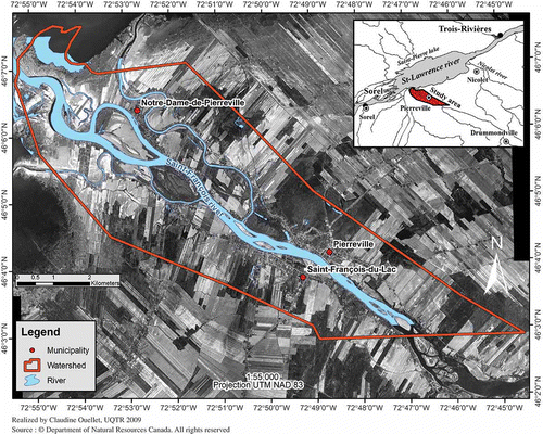
The study area covers the mouth of the Saint-François River, which extends over 48 km2 on the southern shoreline of the St Lawrence River (). The delimitation of the study area is based on watershed boundaries defined by the Board of Water Governance of the Saint-François River Basin (COGESAF Citation2006). The area is encompassed in the northern portion of the large basin of the Saint-François River that covers more than 10 000 km2. The Saint-François River flows into the St Lawrence River at Lake Saint-Pierre, which forms a natural widening of the St Lawrence River (Lake Saint-Pierre has been part of UNESCO's World Network of Biosphere Reserves since 2000). This area is part of the major physiographic region of the St Lawrence Lowlands, which is characterized by a flat topography ranging from 0 to 60 m in altitude and attaining up to 150 around the Appalachian Plateau (not shown on ). This entire part of the Lowlands features large agricultural areas, while the front part of the Appalachian Piedmont is mainly characterized by forests or agroforestry zones.
Fig. 1 Location map of the study area with the mouth of the Saint-François River (southern Québec).
Similar to several southern regions in Québec, the climate in this region is characterized by harsh winters and relatively short summers. Annual mean temperatures range from 4.2 to 5.8°C and annual mean precipitation from 989 to 998 mm per year (COGESAF Citation2006). The freezing of the Saint-François River generally occurs between 5 and 13 December, while the ice-jam period occurs between 31 March and 10 April (Bergeron et al. Citation1977). However, these periods can vary from year to year and depend on the temperatures during the freeze and thaw periods. Moreover, this region has been experiencing milder temperatures and a change in water regime since the 1950s and 1960s (Saint-Laurent et al. Citation2001, Citation2009, Citation2010) taking the form of more frequent flooding in winter. Lastly, the peak discharge on the Saint-François River (Drummondville station, 02OF002) for 1925–2002 is 2719 m3 s-1 and the mean annual maximum and annual discharge are 1417 and 189 m3 s-1, respectively ().
Table 1 Hydrological characteristics of the gauging station no. 02OF002 at Drummondville (Hemmings Falls)
Because of its climate and flow characteristics, the Saint-François River experiences annual and periodic flooding. Riverside residents are routinely subjected to spring floods, especially when the snow cover is also rapidly melting and there is abundant rainfall. The mouth of the Saint-François River is particularly prone to spring floods as a result of the ice jams that occur there, the shoals, and the low streamflow at that location. Furthermore, its confluence with the St Lawrence River (Lake Saint-Pierre) can at times hinder the flow of ice downstream when water levels are high and Lake Saint-Pierre's ice sheet remains frozen downstream. In fact, all of these conditions favour the formation of ice jams, which often cause water levels to quickly rise upstream and thus increase the risk of flooding. Ice jams are clearly the main cause of flooding in this area. Following several major flood events, which occurred in the early 1970s and impacted on a number of riverside municipalities located along the St Lawrence River, including those along the Saint-François and Nicolet Rivers, mitigation measures were implemented to reduce and minimize flood risks. Some of the measures set up by the government consist of a flood prevention programme that includes detailed mapping of flood-risk areas along with icebreaking operations at the mouth of the rivers where spring ice jams occur (CCG Citation2009). In the case of the Saint-François River, icebreaking operations began in the spring of 1976 and have continued each spring to reduce ice jams at the river mouth.
Records of flood events
To help assess the recurrence of floods in the study area, a survey of flood events was conducted using various document sources (e.g. government reports, indexed newspaper articles, monographs, CIEQ (Centre Interuniversitaire d'Études Québecoises) database for the period of 1865–2005. The data gathered in these documents were mainly of a qualitative nature and included assessments of the damage caused to infrastructures, as well as the number of persons evacuated during high river-water levels or flooding. For each recorded event, the date, duration, location, nature, elements pertaining to the causes and effects, and the title of the documents consulted were entered into a computerized database. These various documents have proven to be an important source of information for identifying flood events and their magnitude and are being used by a number of researchers (e.g. Thorndycraft et al. Citation2002, Saint-Laurent and Saucet Citation2003, Barriendos and Rodrigo Citation2006, Seidel et al. Citation2009). Though this type of documentation is used less frequently in hydrological studies dealing with flood recurrence, it is an additional source of information to supplement or validate hydrological data. However, the data are sometimes incomplete in the available documents (e.g. newspapers, government reports) and it is difficult to correctly interpret them. For example, some records show the number of days of flooding and others focus on the damage caused by flooding, and sometimes both types of information are available. To determine the flood frequency, we first counted the number of flood events in five-year intervals (e.g. 1865–1870/2 floods), after which we calculated the flood frequency and the relative flood frequency for each group for the complete time series (1865–2005).
Climatic data
To assess the climatic variations in the study area over the past century, the available climatic data (1914–2003) from historical records of Adjusted and Homogenized Canadian Climate Data (AHCCD, EC Citation2008) were analysed, including monthly temperature and precipitation. These data were obtained from government website databases (EC Citation2001, EC Citation2008) (daily data are not available in the historical records of AHCCD). The Sorel (7028200), Nicolet (7025440), Drummondville (7022160) and Pierreville (7026043) meteorological stations were used to better characterize the climatic data in the study area. The available data for the Sorel, Nicolet and Drummondville cover the period from 1914 to 2003 and for the Pierreville station – from 1981 to 2000. As the coverage for the Pierreville station climatic data is shorter (1981–2000) compared to the other meteorological stations, we opted to use the data from the three nearby stations in order to model the missing data and thus cover a longer period, i.e. from 1914 to 2003. We infilled the missing data from Pierreville station using a simple linear regression equation () based on the nearby stations (Nicolet, Drummondville and Sorel) with the highest degree of determination (r 2).
Table 2 Simple linear regression analysis of climatic data (temperature, precipitation) of the three reference stations (Nicolet, Drummondville and Sorel)
The data series is considered to be homogeneous if the residuals from the regression line are independent. In climatic studies, reference series (or sites) are commonly selected on the basis of distance and correlation under assumption that data from nearby stations should reflect the local and regional climate. In this case, the values obtained by linear regression are highly positively correlated (exceed r 2 = 0.75) with a 5% significance level (p value). shows the climatic variables with the highest correlation in order to model data for the Pierreville station over a longer period of time (i.e. 89 years). For instance, the Nicolet reference station had the highest correlation for maximum and mean temperature and rain precipitation and total precipitation with determination coefficients of 0.990, 0.997, 0.855 and 0.756, respectively. The minimum temperature and snow precipitation were predicted using the Drummondville and Sorel reference stations (r 2 = 0.996 and 0.925, respectively).
Mapping data
The land-use changes from 1928 to 2005 were characterized using available aerial photographs that covered the study area. The series of aerial photographs tally with the time coverage of the climatic data from the weather stations that were analysed. The aerial photographs from 1998 and 2005 were already available in digital format, and those from 1928, 1964 and 1979, which were not available in digital form, were scanned. In all, 34 pictures covering the series of conventional aerial photographs were converted into digital form.
Georeferencing
The aerial photographs (1928, 1964 and 1979) were georeferenced using the Orthoengine module of Geomatica 9.1. Georeferencing was done on the mapping between the control points obtained from vectors on National Topographic Data Base (NTDB) map sheet 031I02 available on the government website (NRC Citation2009). These vectors included watercourses, main roads, secondary roads and toponymic points. The control points were selected based on temporally stable geographic reference points (e.g. bridges, roads). For instance, preference was given to the junction of two roads, though other elements (e.g. island or junction between two watercourses) may also have been used. To obtain accurate georeferencing, the control points were spatially spread out as evenly as possible over each image. The error induced between the position of each control point on the vector and on the image was used to validate the selection of points to limit image distortion. The polynomial equation of the root mean square error (RMSE) was applied to calculate the error between the control points and that of the aerial photographs:
Table 3 Root mean square error (RMSE) from each year used for georeferencing aerial photographs
Mosaics and polygons
The aerial photographs required to cover the study area were grouped into mosaics to facilitate geospatial data analysis (). For instance, all the aerial photographs for 1979 were grouped into a single mosaic to facilitate the analysis. This method was used for each year of the chosen aerial photographs so that a grouping of georeferenced images for the entire study area could be obtained. A spatial database was created to incorporate all the vector files and mosaics to minimize manipulation with the ArcGIS 9.3 software program. Land use was determined based on the three major land categories, i.e. farmland, forests and urban areas. The characterization was done based on an analysis of the surface areas of the mosaics from different years by creating polygons that cover the surface areas based on the three main categories mentioned above. The surface areas of the various types of land use were calculated for each selected year in order to determine the gains and losses using the Spatial Statistics Tools/Calculate Areas in ArcGIS 9.3. In addition, the overlay of the various surface areas from year to year was mapped to visually identify the extent of the changes that occurred in the study area over the target period (1928–2005).
Table 4 List of aerial photographs and vector files used for scanning and creating high-resolution mosaic maps
Statistical analysis
Before proceeding with the statistical analysis, the homogeneity of the data first had to be checked. For this study, the data originate from government records (temperature and precipitation data) that are generally checked and revised to ensure they are valid (Vincent and Gullett Citation1999, Vincent et al. Citation2002). For the Pierreville weather station (EC Citation2008), located directly in our study area, the series of temperature and precipitation data cover a fairly short period (i.e. 19 years), which makes it more difficult to observe long-term trends. To counter this problem, we modelled the climatic data from the Pierreville station against the surrounding stations (Nicolet, Sorel and Drummondville). The data modelling was performed using a simple linear regression model ().
Statistical tests were also used for the chronological series of flood events based on the number of events per year and by month. The chronological series was first broken down into two separate periods, i.e. pre-1976 and post-1976, that being the year in which icebreaking operations were started at the mouth of the Saint-François River. This breakdown of the chronological series into two separate groups is used to reduce the bias that can be introduced into the statistical analysis given that the mitigation measures (icebreaking operations) have an important impact on the decrease in spring floods. Note, furthermore, that the breakdown of the series into two groups tallies with the break observed in the flood recurrence data. Lastly, a chi-squared test (Pearson) was conducted to determine whether the two groups (1865–1974 and 1975–2005) differed significantly. The critical value (p value) equal to or less than 0.05 allowed us to determine whether there is a significant difference between the groups being compared. A first test was performed on the two groups (1865–1974 and 1975–2005) and a second test was done for the winter (December-January-February, DJF) corresponding to the formation of the ice cover, as well as for the spring (March-April-May, MAM), a critical period for the creation of ice jams, in order to assess the impact of icebreaking operations.
The trend analysis of climatic data (temperature and precipitation) of Pierreville station was done using the Mann-Kendall statistical test with SAS/SYSTAT12 (SAS 2000). The Mann-Kendall test is a non-parametric method, meaning that there is no assumption of a statistical distribution (i.e. normal distribution). This analysis enabled us to determine a trend in the data based on the statements in the null (H0) or alternate (H1) hypotheses. In the present case, we are attempting to identify a trend based on the H0 hypothesis, which states that the mean temperature is similar throughout the period, compared to hypothesis H1, which states that there has been an increase or decrease in the mean temperature over the period being observed with a significance level of 5%. In other words, the Mann-Kendall test allows us to determine whether the observed upward or downward trend is significant or not.
RESULTS AND DISCUSSIONS
Flood recurrence
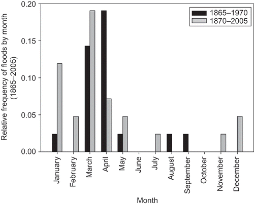
shows the relative flood recurrence from 1865 to 2005 in five-year groupings. A major disparity can be noted between the periods 1865–1974 and 1975–2005, where the break point is centred on the period 1975–1980. The first group, which covers the period from 1865 to 1974, shows a relatively lower recurrence than the second group (1975–2005). When the chi-squared test (Pearson) is done on the entire chronological series (1865–2005), the resulting value (p = 0.0156) shows a major difference between the two groups. In addition, presents the relative flood recurrence by month for the entire chronological series. It can be quickly noted that flooding mainly occurs in the spring (MAM), when the ice cover melts and the Saint-François River ice breaks up. However, an increase in flood recurrence can be seen for January, February, March, July, November and December, along with a decrease for April and May for the 1975–2005 group, revealing a marked change in flood recurrence in the winter and spring. Similar observations were made by Saint-Laurent et al. (Citation2001, Citation2009) for the catchments upstream of the Saint-François River. In fact, an increase in the number of floods was noted for the winter months (DJF), mainly starting in the 1970s, along with a higher flood recurrence in March rather than in April. Moreover, other Canadian researchers (Beltaos Citation2002, Beltaos and Burrell Citation2003, Andrishak and Hicks Citation2008) noted that ice jams tended to occur earlier in the winter.
Fig. 2 Relative flood frequency between 1865 and 2005 using the chi-squared test (Pearson).
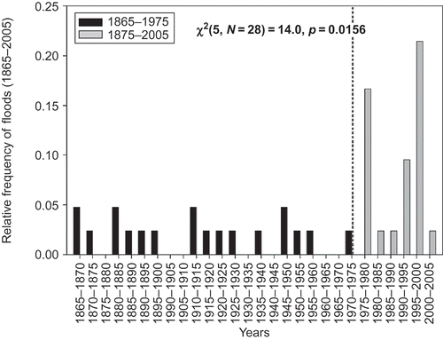
Fig. 3 Analysis of monthly flood frequency from 1865 to 2005.
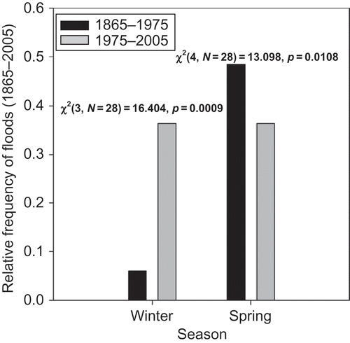
Flood events were grouped into two categories, winter (DJF) and spring (MAM), to assess the impact of the icebreaking operations begun in the spring of 1976 (). A slight decrease in flood recurrence was noted in the spring for the 1975–2005 group, in contrast to the winter, where a slight increase was observed. A chi-squared test performed on each of the two periods confirms that the increase in relative recurrence observed in the winter (DJF) is significant (p = 0.0009) between the two groups. In addition, the results obtained for the spring (MAM) show that the decrease between the two groups is statistically significant (p = 0.0108).
Fig. 4 Relative flood frequency (1865–2005) for the winter (DJF) and spring (MAM) from 1865 to 2005 (Pearson's chi-squared test).
Overall, it might appear that the icebreaking operations at the mouth of the Saint-François River would have a more pronounced impact on the decrease in the number of floods in this area. However, the flood recurrence analysis by month instead shows that flooding has tended to increase in December, January, February and March for the past three decades ( and ), concealing the actual impact of the operations. An increase in flooding has also been noted in May, July and November after 1975. The floods that may occur in December, January and February appear to be relatively unaffected by the spring icebreaking operations, which also helps lessen the impact of these measures on flood recurrence.
In summary, the recurrence of flood events in this area shows greater variability on an inter-annual scale since 1975. The analysis performed on the two groups (winter and spring) confirms an increase in flooding during the winter and a decrease in the spring, particularly in April (). In addition, the inter-annual variability of flood events shows a major change in their recurrence that may be correlated with climate warming over the past decades (Zhang et al. Citation2000, Whitfield et al. Citation2002, Yagouti et al. Citation2008, Saint-Laurent et al. Citation2009).
Climatic variability
Given the higher recurrence of flooding in the winter over recent decades, it would be useful to examine how climate influences this phenomenon. Climate data (temperature and precipitation) accessed in government records from Environment Canada (EC Citation2008) are provided by month and year (no daily data are available on the records). We used data from the climatic station of Pierreville (1981–2000) which is in the study area. As explained previously, data from the Pierreville station were modelled using the three surrounding meteorological stations to obtain a longer coverage period (i.e. 1914–2003). The climatic variance analysis (trend analysis) performed first on temperature data for the time series of 1914–2003 (EC Citation2009) shows that there is a significant trend toward an increase in mean temperatures, particularly for mean minimum temperatures (MMT) (). Trend analyses reveal that MMTs are on the rise for January, February, March, April and May, but not for December, where the resulting value does not particularly stand out. This increase in winter and spring temperatures was first observed in southern Québec (Yagouti et al. Citation2008, Saint-Laurent et al. Citation2009) and elsewhere in Canada (Zhang et al. Citation2000, Bonsal et al. Citation2001, Whitfield et al. Citation2002, Andrishak and Hicks Citation2008). In addition, the trends observed across Canada show a decrease in the frequency of cold days and nights as well as frost days (Bonsal et al. Citation2001, Vincent and Mekis Citation2006, Yagouti et al. Citation2008). These overall milder temperatures agree with the analysis of our climatic data, which point to milder winters than at the turn of the century, for instance. The warmer winter temperatures could cause a partial melting of the ice cover and an increase in water inflow, increasing the risk of major flooding, especially if the mouth of the river is still covered by ice. For example, the most recent flood, deemed extreme by municipal authorities, occurred in January 2008 following abundant rainfall that caused water levels in the Saint-François River to rise by several metres, leading to the evacuation of at least 170 residents in the municipality of Notre-Dame-de-Pierreville (Le Nouvelliste, 10 January 2008).
Table 5 Trend analysis (Mann-Kendall test) for the winter and spring mean minimum temperature (MMT) and mean total precipitation (MTP) for Pierreville station between 1914 and 2003 (H0: no trend; H1: upward (+) or downward (−) trend)
Major variations can also be observed in precipitation data. The results of statistical analyses for mean total precipitation (MTP) show a downward trend in the precipitation rate, with a drop in total rainfall for some months (January, February, March, April and May). However, there is no significant trend for April and May, though the resulting value for April (p = 0.06) is close to the 0.05 threshold (5% significance level). In general, the results of the statistical analyses reveal a decrease in precipitation during the winter (January and February) and in March, and this tallies with the trends observed by Vincent and Mekis (Citation2006) and Yagouti et al. (Citation2008) for southern Québec. However, Yagouti et al. (Citation2008, p. 243) reported an increase in the annual total rainfall (from 1960 to 2005), though many stations indicate decreasing trends of precipitation during the summer. Also, the intensity of precipitation on a given day, as well as the number of consecutive days without precipitation, are on the decline for certain weather stations in southern Québec (Yagouti et al. Citation2008). In the southern portion of the Saint-François River Basin (e.g. Sherbrooke and Lennoxville in the Appalachians region), we also observed an increase in the total rainfall, particularly during the period 1970–1990 (see Saint-Laurent et al. Citation2009, pp. 50–51).
For other regions in southern Canada, the study of Zhang et al. (Citation2000) shows an upward trend with regard to annual precipitation (5% to 35%) during 1900–1998. These authors also noted an increase in precipitation in terms of percentages in eastern Canada throughout the four seasons, but the trends were not statistically significant for southern Québec during winter and spring (Zhang et al. Citation2000, p. 411). These results are representative of the trends observed for our study area. The period under study (1914–2003) also shows that the trends observed with respect to precipitation data are characterized by fairly substantial inter- and intra-annual variability.
Land-use changes and flood-risk areas
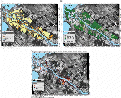
For this part of the study, land use was characterized based on three major categories, i.e. farmland, forests and urban areas. The spatial coverage expressed as a percentage for each category is presented in . For the period under study (1928–2005), a small decrease in agricultural surface areas, from 53% to 39% is observed (), along with an increase in forest () and urban surface areas (), from 27% to 38% and from 3% to 5%, respectively. Note that the percentages obtained come from the surface areas calculated using digitized map polygons originating from aerial photographs georeferenced for the available series (e.g. 1928, 1964, 1979). Overall, the profile for this area remains virtually unchanged since the 1960s. The landscape of the region is still predominantly rural, despite a certain agricultural abandonment in the form of reforestation of former abandoned land that has become agricultural wild land and woodland ( and ). Moreover, there has been little increase in the size of urban areas since 1964 (). In this regard, when reviewing the census data for 1921–2006, a decrease in the population of the towns in this area can be noted, from about 4779 residents in 1921 to 2337 in 2006 (Census Canada Citation1923, Statistics Canada Citation2008).
Fig. 5 Percentage of agricultural, forest and urban surfaces in the study area between 1928 and 2005.
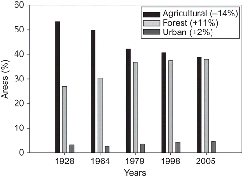
Fig. 6 (a) Changes in farmland between 1964 and 2005; calculated loss of 14% since 1928. (b) Changes in woodland between 1964 and 2005; calculated gain of 11% since 1928. (c) Changes in urban areas between 1964 and 2005.
Based on the digitized data that were obtained, the woodlands are not large enough (38% of the study area in 2005) to adequately counter the effects of the surface runoff. Furthermore, these wooded areas are at times located at a fair distance from the riverbanks (), which reduces their potential impact on surface runoff. Lastly, the small proportion of forest land in this area, as well as in the upstream part of the catchment (Castonguay et Saint-Laurent Citation2009, Saint-Laurent et al. Citation2009, Citation2010), suggests that it cannot be a determining factor in the overall assessment of the intercepted waters during periods of heavy rain. It is known that the type and density of the vegetation cover, as well as urbanization, have a direct impact on surface runoff and, as a result, on the hydrological response of rivers and streams (Chase et al. Citation2000, Reynard et al. Citation2001, Rey et al. Citation2004, Wissmar and Timm Citation2004, Camorani et al. Citation2005, Ferreira et al. Citation2005, Allen et al. Citation2008, Toba and Ohta Citation2008, Huaxia et al. Citation2009). The vegetation cover not only allows rainwater to be intercepted, but its efficacy is dependent on the proportion of its coverage, distribution and type (e.g. farmland, woodland). Rey et al. (Citation2004), for instance, adequately demonstrated that the impact of surface runoff has substantially decreased for an area with a proportion of woodland in excess of 70%. Wissmar and Timm (Citation2004) also show the link between changes in the forest cover and streamflow recurrence during flood events. For instance, the authors noted an abrupt increase in the flow rate when the forest cover was low (range of 17 to 37%) and, conversely, the lowest flows occurred when the forest cover was greatest (range of 59 to 81%). Finally, other researchers have demonstrated the propagation difference of a flood wave during rainfall before and after urbanization of an area (Camorani et al. Citation2005, Allen et al. Citation2008). With regard to the study area, the urbanized areas remain marginal such that they do not truly constitute a limiting factor in the exacerbation of surface runoff.
CONCLUSIONS
This study deals with the recurrence of flood events (from 1865 to 2003) in connection with climate change and land-use changes at the mouth of the Saint-François River. This area was chosen because of the high number of floods that occur there and their impact on riverside communities. Note that flood frequency has been on the rise since 1975, despite the use of de-icing operations, which were begun in 1976 by the Canadian Coast Guard. Note also that floods have been occurring more often in the winter since the early 1970s, marking a change in hydrodynamic conditions. The climatic data analysis reveals an increase in temperatures over the winter (December, January and February), which may account for the greater number of floods during this period. These warmer temperatures cause a partial thawing of the ice cover along with an increase in precipitation in the form of rainfall (rather than snow), which increases the risk of flooding by increasing the surface runoff.
With respect to land-use changes, there has been a progressive increase in the size of forest areas from 1928 to 2005, in the form of an 11% reforestation of the study area to the detriment of farmland that resulted in a total reduction in surface area of 14%. However, these changes are minor over the entire catchment and do not appear to have a real impact on flood recurrence.
Lastly, note that the lowlands in the area mainly feature cultivated land, agricultural wildland and woodlands, while more densely populated areas (e.g. Pierreville, Saint-François-du-lac) over the Saint-François River are located in lower flood-risk areas. Note that since 1987, the government's policy on the protection of riverbanks, coastlines and floodplains also ensures that these areas will be preserved to some extent, with any permanent structures in flood-risk areas being basically prohibited (MDDEP Citation1987). Moreover, the Coast Guard's efforts since 1976 to prevent the creation of ice jams at the river mouth have also helped reduce the risk of flooding. However, the town of Pierreville and the other neighbouring villages remain highly prone to flooding and are subject to it on a recurring basis. The most recent flood occurred in January 2008 following a rapid rise of the Saint-François River that put the town on alert and led to the evacuation of residents. If the trend toward milder winters continues, these flood events may occur more frequently. It will therefore be necessary to revise current flood-risk maps (CEHQ Citation2009) and create new ones to ensure greater protection of riverside residents most likely to be affected by flooding. Similarly, new riverside developments will be needed that are suitable for the new hydrological conditions that accompany climate-related trends (Musik 2001, Chase et al. Citation2000, Hirabayashi et al. Citation2008, Whitehead and Robinson Citation1993, Whitehead et al. Citation2010). These measures may be highly varied (e.g. widening of riverside strips, riverbank reforestation, creation of new green spaces) and could lead to different land use that is more oriented toward leisure activities, as well as landscape value, and aimed at environmental protection. All of these measures primarily aim to ensure better protection for riverside residents and a decrease in the cost of flood-related damage.
Acknowledgements
The authors thank the CRSNG and FIR-UQTR for funds that supported this research. The authors also express special thanks to the reviewers for their constructive comments.
Related Research Data
REFERENCES
- Alcamo , J. , Flörke , M. and Märker , M. 2007 . Future long-term changes in global water resources driven by socio-economic and climatic change . Hydrological Sciences Journal , 52 ( 2 ) : 247 – 275 .
- Allen , P. M. , Arnold , J. G. and Skipwith , W. 2008 . Prediction of channel degradation rates in urbanizing watersheds . Hydrological Sciences Journal , 53 ( 5 ) : 1013 – 1029 .
- Andrishak , R. and Hicks , F. 2008 . Simulating the effects of climate change on the ice regime of the Peace River . Canadian Journal of Civil Engineering , 35 ( 5 ) : 461 – 472 .
- Barriendos , M. and Rodrigo , F. S. 2006 . Study of historical flood events on Spanish rivers using documentary data . Hydrological Sciences Journal , 51 ( 5 ) : 765 – 783 .
- Beltaos , S. 2002 . Effects of climate on mid-winter ice jams . Hydrological Processes , 16 ( 4 ) : 789 – 804 .
- Beltaos , S. and Burrell , B. C. 2003 . Climatic change and river ice breakup . Canadian Journal of Civil Engineering , 30 ( 1 ) : 145 – 155 .
- Bergeron , G. , Ferland , M. , Houde , A. and Lamb , P. 1977 . Hydrométéorologie du bassin versant de la Saint-François , 179 Québec : Service de la météorologie, Ministère des richesses naturelles, Programme des connaissances intégrées .
- Bonsal , B.R. , Zhang , X. , Vincent , L.A and Hogg , W.D. 2001 . Characteristics of daily and extreme temperatures over Canada . Journal of Climate , 14 : 1959 – 1976 .
- Bronstert , A. , Niehoff , D. and Burger , G. 2002 . Effects of climate and land use change on storm runoff generation: present knowledge and modelling capabilities . Hydrological Processes , 16 ( 2 ) : 509 – 529 .
- Camorani , G. , Castellarin , A. and Brath , A. 2005 . Effects of land-use changes on the hydrologic response of reclamation systems . Physics and Chemistry of the Earth , 30 ( 8-10 ) : 561 – 574 .
- CCG (Canadian Coast Guard), 2009. Icebreaking program. Fisheries Canada and Oceans Canada http://www.ccg-gcc.gc.ca/eng/CCG/Ice_Home (http://www.ccg-gcc.gc.ca/eng/CCG/Ice_Home) (Accessed: 12 March 2010 ).
- Castonguay , S. and Saint-Laurent , D. 2009 . “ Reconstructing reforestation: changing land use patterns along the Saint-François River in the Eastern Townships ” . In Method and meaning in Canadian environmental history , Edited by: MacEachern , A. and Turkel , E.J. 273 – 292 . Toronto : Th. Nelson . edsl
- CEHQ (Centre d'Expertise Hydrique du Québec), 2009. Cartes du risque d'inondations. Ministère du Développement Durable, de l'Environnement et des Parcs http://www.cehq.gouv.qc.ca/zones-inond/index.htm (http://www.cehq.gouv.qc.ca/zones-inond/index.htm) (Accessed: 20 March 2010 ).
- Canada , Census . 1923 . Report of sixth Census of Canada 1921, Population, number, sex, racial origins , Vol. 1 , Ottawa , , Canada : Departement of Trade and Commerce .
- Chase , T.N. 2000 . Simulated impacts of historical land cover changes on global climate in northern winter . Climate Dynamics , 16 ( 2–3 ) : 93 – 105 .
- COGESAF, 2006. Analyse du bassin versant de la rivière Saint-François. Comité de gestion du bassin versant de la rivière Saint-François. Plan directeur de l'eau (PDE) http://www.cogesaf.qc.ca/index.php?option=com_contentandview=articleandid=70andItemid=116 (http://www.cogesaf.qc.ca/index.php?option=com_contentandview=articleandid=70andItemid=116) (Accessed: 8 May 2010 ).
- EC (Environnement Canada), 2001. Canadian climate normals 1971–2000. Ottawa, Canada: Meteorological Service/climate_normals/index_e.html http://www.climate.weatheroffice.ec.gc.ca (http://www.climate.weatheroffice.ec.gc.ca) (Accessed: 12 March 2010 ).
- EC (Environnement Canada), 2010. The Second Generation Coupled Global Climate Model. Canadian Centre for Climate Modelling and Analysis http://www.cccma.ec.gc.ca/models/gcm4.s.html (http://www.cccma.ec.gc.ca/models/gcm4.s.html) (Accessed: 13 December 2010 ).
- EC (Environnement Canada), 2008. Adjusted Historical Canadian Climate Data (AHCCD). Canada: Meteorological Service, Climate Research Branch http://www.cccma.bc.ec.gc.ca/hccd/ (http://www.cccma.bc.ec.gc.ca/hccd/) (Accessed: 12 March 2010 ).
- EC (Environnement Canada), 2009. Québec Region—Designated areas as subject to recurrent and severe flooding http://www.ec.gc.ca/eau-water/default.asp?lang=Enandn=09DACE2F-1 (http://www.ec.gc.ca/eau-water/default.asp?lang=Enandn=09DACE2F-1) (Accessed: 12 March 2010 ).
- Ferreira , M.T. , Aguiar , F.C. and Nogueira , C. 2005 . Changes in riparian woods over space and time: influence of environment and land use . Forest Ecology and Management , 212 ( 1-3 ) : 145 – 159 .
- Fohrer , N. , Haverkamp , S. and Frede , H.-G. 2005 . Assessment of the effects of land use patterns on hydrologic landscape functions: development of sustainable land use concepts for low mountain range areas . Hydrological Processes , 19 : 659 – 672 .
- Hirabayashi , Y. 2008 . Global projections of changing risks of floods and droughts in a changing climate . Hydrological Sciences Journal , 53 ( 4 ) : 754 – 772 .
- Huaxia , Y. , Michio , H. , Jun , X. and Xiaohong , C. 2009 . Runoff reduction by forest growth in Hiji River basin, Japan . Hydrological Sciences Journal , 54 ( 3 ) : 556 – 570 .
- IFI (International Flood Initiative), 2010. The fourth international flood initiative and international conference of flood management http://www.ifi-home.info/e-Meetings-and-Workshops.html (http://www.ifi-home.info/e-Meetings-and-Workshops.html) (Accessed: 20 November 2010 ).
- IHP (International Hydrological Programme), 2008. The UNESCO international scientific co-operative programme in hydrology and water resources http://typo38.unesco.org/en/themes/global-changes-and-water-resources.html (http://typo38.unesco.org/en/themes/global-changes-and-water-resources.html) (Accessed: 20 November 2010 ).
- IPCC (Intergovernmental Panel on Climate Change), 2007a. Summary for policymakers. In: S. Solomon et al., eds., Climate change 2007: The physical science basis. Contribution of Working Group I to the Fourth Assessment Report of the Intergovernmental Panel on Climate Change. Cambridge: Cambridge University Press, 1–18 http://www.ipcc.ch/pdf/assessment-report/ar4/wg1/ar4-wg1-spm.pdf (http://www.ipcc.ch/pdf/assessment-report/ar4/wg1/ar4-wg1-spm.pdf) (Accessed: 10 March 2010 ).
- IPCC (Intergovernmental Panel on Climate Change), 2007b. Summary for policymakers. In: M.L. Parry et al., eds., Climate change 2007: Impacts, adaptation and vulnerability. Contribution of Working Group II to the Fourth Assessment Report of the Intergovernmental Panel on Climate Change. Cambridge: Cambridge University Press, 7–22 http://www.ipcc.ch/pdf/assessment-report/ar4/wg1/ar4-wg1-spm.pdf (http://www.ipcc.ch/pdf/assessment-report/ar4/wg1/ar4-wg1-spm.pdf) (Accessed: 10 March 2010 ).
- IPCC (Intergovernmental Panel on Climate Change) . Human settlement, water, energy and transport Infrastructure – mitigation and adaptation strategies . Expert Meeting of WGII and WGII . 22–24 March 2011 , Calcutta , India.
- Kundzewicz , Z.W. 2009 . The implications of projected climate change for freshwater resources and their management . Hydrological Sciences Journal , 53 ( 1 ) : 3 – 10 .
- Leith , R.M. and Whitfield , P.H. 1998 . Evidence of climate change effects on the hydrology of streams in south-central British Columbia . Canadian Water Resources Journal , 23 : 219 – 230 .
- Maret , I. and Goeury , R. 2008 . La Nouvelle-Orléans et l'eau: un urbanisme à haut-risque . Environnement urbain/Urban Environment , 2 : 107 – 122 .
- May , C.W. and Horner , R.R. 2000 . “ The cumulative impacts of watershed urbanization on stream-riparian ecosystems ” . In Proceedings of the international conference on riparian ecology and management in multi-land use watersheds , Edited by: Wigington , P.J. and Beschta , R.L. 281 – 286 . Middleburg , VA : American Water Resources Association .
- MDDEP (Ministère du Développement Durable, de l'Environnement et des Parcs), 1987. Politique de protection des rives, du littoral et des plaines inondables. Loi sur la qualité de l'environnement (L.R.Q., c. Q-2, a. 2.1), Gouvernement du Québec http://www.mddep.gouv.qc.ca/eau/rives/index.ht (http://www.mddep.gouv.qc.ca/eau/rives/index.ht)
- Mekis , E. and Hogg , W.D. 1999 . Rehabilitation and analysis of Canadian daily precipitation time series . Atmosphere–Ocean , 37 ( 1 ) : 53 – 85 .
- Muzik , I. 2001 . Sensitivity of hydrologic systems to climate change . Canadian Water Resources Journal , 26 : 233 – 252 .
- Natural Resources Canada (NRC), 2009. National Topographic Data Base (NTDB) Canada http://geogratis.cgdi.gc.ca/geogratis/en/collection/detail.do (http://geogratis.cgdi.gc.ca/geogratis/en/collection/detail.do) (Accessed: 8 January 2010 ).
- New , M. , Todd , M. , Hulme , M. and Phil , J. 2001 . Precipitation measurements and trends in the twentieth century . International Journal of Climatology , 21 ( 15 ) : 1889 – 1922 .
- Naef , F. , Scherrer , S. and Weiler , M. 2002 . A process based assessment of the potential to reduce flood runoff by land use change . Journal of Hydrology , 267 : 74 – 79 .
- Niehoff , D. , Fritsch , U. and Bronstert , A. 2002 . Land-use impacts on storm-runoff generation: scenarios of land-use change and simulation of hydrological response in a meso-scale catchment in SW-Germany . Journal of Hydrology , 267 ( 1-2 ) : 80 – 93 .
- Panu , U.S. and Sharma , T.C. 2009 . Analysis of annual hydrological droughts: the case of northwest Ontario, Canada . Hydrological Sciences Journal , 54 ( 1 ) : 29 – 42 .
- Rey , F. , Ballais , J. L. , Marre , A. and Rovéra , G. 2004 . Role of vegetation in protection against surface hydric erosion . Geoscience , 336 ( 11 ) : 991 – 998 .
- Reynard , N.S. , Prudhomme , C. and Crooks , S.M. 2001 . The flood characteristics of large UK rivers: potential effects of changing climate and land use . Climatic Change , 48 : 343 – 359 .
- Saint-Laurent , D. , Couture , C. and McNeil , E. 2001 . Spatio-temporal analysis of floods of the Saint-François drainage basin, Québec, Canada . Environments , 29 : 74 – 90 .
- Saint-Laurent , D. and Hähni , M. 2008 . Crues et inondations majeures des villes de l'Estrie: variations climatiques et modifications anthropiques (Québec, Canada) . Environnement urbain/Urban Environment , 2 : 50 – 72 .
- Saint-Laurent , D. 2010 . Floodplain sedimentation rates, soil properties and recent flood history in Southern Québec . Global and Planetary Change , 70 : 76 – 91 .
- Saint-Laurent , D. , Mesfioui , M. and Evin , G. 2009 . Hydroclimatic variability and relation with flood events (Southern Québec, Canada) . Water Resources , 36 ( 1 ) : 43 – 56 .
- Saint-Laurent , D. and Saucet , J.-P. 8–10 June 2003 . “ Chronological reconstitution of floods of the Saint-François drainage basin ” . In Proceedings of the third Canadian conference on geotechnique and natural hazards , 8–10 June , 89 – 93 . Alberta , , Canada : Edmonton .
- SAS (Statistical Analysis System), 2000. SAS/STAT User's Guide. Release 8.02 TS Level 02M0.
- Seidel , J. 2009 . Potential of historical meteorological and hydrological data for the reconstruction of historical flood events - the example of the 1882 flood in southwest Germany . Natural Hazards and Earth System Science , 9 ( 1 ) : 175 – 183 .
- Sharma , T.C. and Panu , U.S. 2008 . Drought analysis of monthly hydrological sequences: a case study of Canadian rivers . Hydrological Sciences Journal , 53 ( 3 ) : 503 – 518 .
- Statistics Canada, 2008. Official web site of Statistics Canada http://www.statcan.gc.ca/start-debut-eng.html (http://www.statcan.gc.ca/start-debut-eng.html) (Accessed: 19 January 2010 ).
- Stern , N. , ed. 2007 . Stern Review: The economics of climate change , Cambridge : Cambridge University Press, UK .
- Sullivan , A. , Ternan , J.L. and Williams , A.G. 2004 . Land use change and hydrological response in the Camel catchment, Cornwall . Applied Geography , 24 ( 2 ) : 119 – 137 .
- Tao , H. 2011 . Trends of streamflow in the Tarim River Basin during the past 50 years: Human impact or climate change? . Journal of Hydrology , 400 : 1 – 9 .
- Thorndycraft , V.R. , Benito , G. , Barriendos , M. and Llasat , M.C. , eds. 16–19 October 2002 . “ Palaeofloods, historical data and climatic variability ” . In Applications in flood risk assessment , 16–19 October , 87 – 92 . Spain : Proceedings of the PHEFRA international workshops, Barcelona .
- Toba , T. and Ohta , T. 2008 . Factors affecting rainfall interception determined by a forest simulator and numerical model . Hydrological Processes , 22 ( 14 ) : 2634 – 2643 .
- Tollan , A. 2002 . Land-use change and floods: what do we need most, research or management? . Water Science and Technology , 45 ( 8 ) : 183 – 190 .
- Vincent , L.A. and Gullett , D.W. 1999 . Canadian historical and homogeneous temperature datasets for climatic change analyses . International Journal of Climatology , 19 : 1375 – 1388 .
- Vincent , L.A. and Mekis , E. 2006 . Changes in daily and extreme temperature and precipitation indices for Canada over the twentieth century . Atmosphere–Ocean , 44 ( 2 ) : 177 – 193 .
- Vincent , L.A. , Zhang , X. , Bonsal , B.R. and Hogg , W.D. 2002 . Homogenization of daily temperatures over Canada . Journal of Climate , 15 : 1322 – 1334 .
- Whitaker , A. , Alila , Y. , Beckers , J. and Toews , D. 2002 . Evaluating peak flow sensitivity to clear-cutting in different elevation bands of a snowmelt-dominated mountainous catchment . Water Resources Research , 38 ( 9 ) : 11 – 17 .
- Whitehead , P.G. 2010 . A review of the potential impacts of climate change on surface water quality . Hydrological Sciences Journal , 54 ( 1 ) : 101 – 123 .
- Whitehead , P.G. and Robinson , M. 1993 . Experimental basin studies—an international and historical perspective of forest impacts . Journal of Hydrology. , 145 ( 3-4 ) : 217 – 230 .
- Whitfield , P.H. , Bodtker , K. and Cannon , A.J. 2002 . Recent variation in seasonality of temperature and precipitation in Canada, 1976–95 . International Journal of Climatology , 22 : 1617 – 1644 .
- Wissmar , R.C. and Timm , R.K. 2004 . Effects of changing forest and impervious land covers on discharge characteristics of watersheds . Environmental Management , 34 ( 1 ) : 91 – 98 .
- Yagouti , A. 2008 . Observed changes in daily temperature and precipitation indices for southern Québec, 1960–2005 . Atmosphere–Ocean , 46 ( 2 ) : 243 – 256 .
- Zhang , X. , Vincent , L.A. , Hogg , W.D. and Niitsoo , A. 2000 . Temperature and precipitation trends in Canada during the 20th century . Atmosphere–Ocean , 38 ( 3 ) : 395 – 429 .