Abstract
A technique that utilizes the SCS curve number and dimensionless unit hydrograph and GIS technology has been adopted in this study in order to reconstruct urbanized arid region flash flood magnitude with minimum available data. Estimated values of hydrograph ordinates were routed by utilizing HEC RAS software to reconstruct the flood hydrograph and flood characteristics of the devastating flood event of 25 November 2009 on East Jeddah districts to investigate the effect of levee breach and narrow town streets on water level in the town. The calculated maximum stage of this flood was estimated at 1.34 m in the main wadi channel in the natural condition, but it exceeded 2 m in the narrow streets, reaching about 2.1 m at street entrances in the worst-case scenario of the wet condition; this was found to be due to levee breach and the effect of narrow streets. The latter situation agrees well with actual stage observations in Gueeza streets contradicting the assumption that the flood event was entirely due to natural causes.
Editor Z.W. Kundzewicz
Citation El-Hames, A.S. and Al-Wagdany, A.S., 2012. Reconstruction of flood characteristics in urbanized arid regions: case study of the flood of 25 November 2009 in Jeddah, Saudi Arabia. Hydrological Sciences Journal, 57 (3), 507–516.
Résumé
Une technique utilisant le numéro de courbe SCS, l'hydrogramme unitaire adimensionnel et la technologie SIG a été adoptée dans cette étude afin de reconstituer, avec un minimum de données disponibles, une crue éclair dans une région aride urbanisée. Les valeurs estimées des ordonnées des hydrogrammes ont été utilisées avec le logiciel HEC RAS pour reconstituer l'hydrogramme de crue et les caractéristiques de la crue dévastatrice du 25 Novembre 2009 sur les districts de Jeddah Est, pour étudier l'effet de la rupture des digues et des rues étroites sur le niveau d‘eau dans la ville. Le niveau maximal calculé de cette crue a été estimé à 1,34 m dans le chenal principal de l'oued en conditions naturelles, mais il a dépassé 2 m dans les rues étroites, atteignant environ 2,1 m à l'entrée des rues dans le pire des cas. Cette dernière situation est bien en accord avec les observations réalisées dans les rues de Gueeza, contredisant l'hypothèse que l'inondation était entièrement attribuable à des causes naturelles.
INTRODUCTION
Owing to the absence of adequate rainfall and runoff gauge networks and thus hydrological data, and due to the vigorous urbanization activities in arid areas, as well as temporal and spatial variation of the hydrological characteristics, the quantitative assessment of runoff characteristics in these areas is not straightforward. Also, flood event characteristics in arid and semi-arid regions are poorly understood because of their infrequent occurrence and the lack of studies directed at quantifying their basic phenomena (Vivoni et al. Citation2006). In dry climate regions, rainfall is highly variable and may be of high intensity (Morin et al. Citation2009), which causes flash-flood problems. Much of the uncertainty associated with flash-flooding events is linked to a lack of accurate environmental data (Foody et al. Citation2004, Bahat et al. Citation2009). In addition, expansion of urbanized areas places increasing emphasis on the need to understand flood behaviour, magnitude and occurrence. Changes in both land use and water policy have made it necessary to take into account the rapidly-evolving morphology of urban catchments (Rodriguez et al. Citation2003).
Different methods of using a combination of hydrological approaches, such as the rational method and physical, geomorphological, and statistical techniques, have been adopted to determine the flood peak or flood hydrograph in arid regions by a number of researchers (El-Hames and Richards, Citation1998, Jothityangkoon et al. Citation2001, Foody et al. Citation2004, Sevinç and Şen Citation2007, Bracken et al. Citation2008). However, these methods require intensive calibration and verification with previously recorded events before they can be used to estimate future floods. Where there are no runoff gauges in the area, the problem becomes more pronounced and it is necessary to implement other techniques that require less calibration. Usually these methods utilize satellite images and aerial photography to determine catchment geomorphology, channel geometry and infiltration characteristics, which can then be verified by careful fieldwork (Lange et al. Citation1999). The limited literature on arid-region floods indicates that calibration of physically-based rainfall–runoff models is very problematic and simple empirical or semi-empirical models may perform equally well or even better (McIntyre et al, Citation2007).
In this paper, a method is adopted that relies mainly on catchment geomorphology so that data can be obtained from satellite images and aerial photos. This method can produce reasonable flood hydrographs with minimum calibration and is based on combining the Soil Conservation Service (SCS) Curve Number (CN) approach for calculating excess rainfall and the SCS dimensionless unit hydrograph (UH) for reconstructing the flood hydrograph. This method represents runoff formation reasonably well and is widely used (e.g. Bocchiola and Rosso Citation2009) as ephemeral streamflow catchments lend themselves to direct estimation of the unit hydrograph response curve, most peaks being well-separated, and having little or no overlap with preceding or subsequent flow events (Croke Citation2006).
The method adopted in this paper was verified by testing it against the flood events recorded during 1985 and 1986 in a catchment located in the southwestern region of Saudi Arabia. Although the curve number for the test catchment was not readily available for the flood events used, a technique devised by the authors was used to estimate the curve number for each historical flood event from which excess rainfall was calculated. This method was then used to reconstruct the flash flood hydrograph of the event of 25 November 2009 in East Jeddah district, an event that is well documented in many videos on a number of Internet sites, in particular on YouTube. Since its occurrence, the actual cause of this event has been the subject of much debate amongst municipal planners and decision makers. Knowing the reasons behind this disaster is very important in order to avoid such a tragedy in the future in this area and to present a comprehensible lesson to hydrologists and urban planners worldwide, especially in the context of changing environment due to global warming and intensive urbanization. In order to understand the cause of the Jeddah flash-flood disaster, the flood characteristics had to be reconstructed. The important information needed was obtained by the procedure implemented herein. Firstly, the developed model was tested and calibrated by utilizing previously recorded flood events in other areas. The effect of urbanization, and land-use and land-cover changes on the produced hydrograph was then investigated by routing the developed flood hydrograph in the main wadi channel and through town streets under different scenarios by means of the Hydrologic Engineering Centers River Analysis System model (HEC RAS). We also investigated the effect of levee breach and town streets on water-level change.
METHODOLOGY
A method is devised here to reconstruct the flood hydrograph and stage graph from the available geomorphological data drawn from satellite images and basic fieldwork. This method can be executed according to the following four steps: extraction of catchment border and stream network; adjustment of recorded total rainfall; determination of excess rainfall; and calculation of flood hydrograph and stage graph for the events of interest. In order to reconstruct the stage graph of the event, the developed hydrograph can be routed through the main channel and into town streets to test the effect of natural and man-made structures.
To reconstruct the flood hydrograph, the wadi border and stream network were extracted and prepared from satellite images and digital elevation models (DEM). The corresponding images were treated by geographical information system (GIS) software to extract catchment geomorphological properties. Rainfall data can generally be obtained from the available rainfall records either as intensities or total rainfall. If rainfall intensities are available, they can be used directly, otherwise total rainfall data need to be treated with one of the available rainfall distributions, such as SCS type I, II, III and IA. Calculation of excess rainfall and losses from the total rainfall is done following the SCS CN method. Moisture condition incorporates three conditions according to the antecedent moisture in the area; these are dry, normal and wet. The wide range of land-use and land-cover categories are defined by the US Soil Conservation Service (SCS) (US ACE Citation2009). The composite (overall) catchment curve number (CN) for normal wetness condition is calculated by the following expression:
where ICN represents curve number of a certain part of the area, and AP is the percentage of the area with respect to total catchment area. Curve number values for wet (WCN) and dry (DCN) conditions is calculated by:
The flood hydrograph is reconstructed by applying the SCS dimensionless unit hydrograph method (SCS Citation1972). In terms of calculating excess rainfall (Pe ) this method shows that Pe is related to a potential maximum storage (S) by:
Maximum storage (S) can be calculated from composite curve number (CN) calculated for the catchment (Equationequation (1)(1)) as:
It should be noted that determination of maximum storage depends on the proper calculation of the catchment lag time (tp
) which can be calculated as tp
= 0.6tc
, and tc
is the time of concentration (min) of the catchment. However, time of concentration is the most crucial parameter in this aspect and, therefore, two different formulae have been investigated to calculate it in this work: the Kirpich method (Citation1940) (Equationequation (6)(6)) and the approach of the Federal Aviation Administration (1970) (Equationequation (7)
(7)):
where L is main stream length (ft), SS is average catchment surface slope (ft/ft), SP is the catchment surface slope (%), and C is calculated runoff coefficient. It should be noted that Equationequations (6)(6) and Equation(7)
(7) include the effect of catchment geomorphological parameters, where Equationequation (7)
(7) also incorporates the runoff coefficient which reflects the catchment curve number and the antecedent moisture condition. Calculated unit hydrograph ordinates are multiplied by peak discharge of the unit hydrograph for a catchment and tp
to derive unit hydrograph values (U) for each ordinate (l) based on the previous ordinate (m). Discharge at each ordinate (Qn
) is calculated from excess rainfall by:
For catchments with historical runoff records but no curve number information, a method is derived to calculate curve number from total rainfall (P) and excess rainfall (Pe
), by means of Equationequation (1)(1). Solving Equationequation (1)
(1) for potential maximum storage (S) yields Equationequations (9)
(9) and Equation(10)
(10), valid for different ranges of excess rainfall (Pe
) values:
These equations are solved by the successive iteration method and guarantee to converge to the exact solution if the conditions are met. The calculated value of S can then be substituted into Equationequation (5)(5) to solve for CN for the historical events needed for calibration or verification. Once CN for a particular event is obtained, the distributed excess rainfall for that event is calculated by the SCS method and then direct runoff (flood hydrograph) is calculated by the SCS dimensionless unit hydrograph as suggested above.
In order to study the extent of flood effect on urban areas, it is necessary to reconstruct the flood stage (water depth) produced by a flood event and to investigate the flood height in these areas under different scenarios. This can be done by routing the developed hydrograph through the wadi channel and into town streets, including the effect of any natural or man-made structures under different conditions, as illustrated in the next sections.
Method validation using a catchment with runoff records
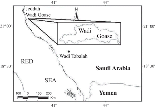
A model with the above equations was programmed and tested for Al-Hamid catchment (area: 170 km2), a part of Wadi Tabalah located in the southwestern region of Saudi Arabia () This catchment was intensely instrumented in the period between 1984 and 1986 by Dames and Moore Company on behalf of the Ministry of Water and Agriculture (currently the Ministry of Water and Electricity), and the collected data were treated as the most comprehensive and reliable in the area. However, it should be emphasized that these data were obtained by digitizing and extrapolating hardcopies of recorded hydrographs which were not very convenient and produced marginal error. Also, data were available from a number of total rainfall gauges, as well as a runoff station at the catchment outlet. These data represent total rainfall and not rainfall intensity. This may create problems when event-based analysis is of concern, as this requires rainfall intensity records rather than total rainfall records. However, due to lack of any other information of this kind these data were used for method verification.
Fig. 1 Location of study and validation areas.
Five flood events were investigated for which the total rainfall was temporally distributed by the SCS Type I method. The rainfall characteristics of these events are shown in . Distribution of excess rainfall over time is needed; however, no CN data were available for these events to allow us to calculate excess rainfall distribution. Thus, the method suggested above to evaluate curve number values was implemented. Excess rainfall was calculated from flood volume (direct runoff) for each event by calculating the flood depth over the catchment. By using the excess rainfall values, the storage (S) was calculated from Equationequations (9)(9) and Equation(10)
(10) and then the CN values were obtained from Equationequation (5)
(5). Once the CN value for a particular event is obtained (as shown in ), the distributed excess rainfall for that event may be calculated by SCS Type I rainfall distribution method and then the direct runoff (flood hydrograph) is calculated by the SCS dimensionless unit hydrograph. Values of observed and simulated peak flow are shown in . The results in agree reasonably well with the observed results in terms of peak flow, although there are some variations. This is understandable given the difficulty of obtaining the original data, as explained above, and the approximate data of recorded total rainfall where there are neither temporal nor spatial rainfall distribution records. In spite of these limitations, the adopted method was still able to simulate previous flood events in wadi Al-Hamid reasonably well.
Table 1 Rainfall data for the tested runoff events at Wadi Al-Hamid
Table 2 Applied method simulated runoff vs observed runoff data at Wadi Al-Hamid
Application to Wadi Goase; case study of 25 November 2009
The area of Jeddah that experienced the flood of 25 November 2009 is located in the eastern part of the main ring road around Jeddah city ( and ). This area is located on the western part of the Asir escarpment, which act as a barrier for the moist-rich air masses coming from the northwest and causes convectional lift that results in air mass condensation and increases the possibility of rainfall in the area, especially during the rainy season of December–March. The study area receives annual rainfall of about 50 mm. The storm preceding the flood event covered an area more than 150 km long and 50 km wide, including a number of major cities such as Jeddah, where Gueeza town was one of the most affected areas. Gueeza is located in the downstream area of Wadi Goase catchment () toward the east of Jeddah.
Fig. 2 Wadi Goase catchment, channel network and Gueeza district.
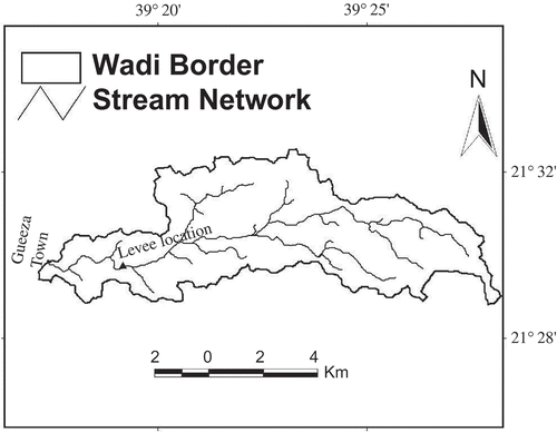
The wadi border and stream network has been extracted and prepared from ASTER DEM satellite images with a cell resolution of 30 m, obtained from NASA (http://www2.jpl.nasa.gov/srtm/). The corresponding images were treated by Water Modelling System (WMS) GIS software to extract the catchment geomorphological properties. The extracted catchment border and wadi network are shown in and the geomorphological parameters obtained are shown in .
Table 3 Wadi Goase catchment geomorphological characteristics
Rainfall data were obtained from the Ministry of Water and Electricity records of the event on 25 November 2009 at the station located about 15 km downstream of the Wadi Goase catchment outlet. This is the only station with intensity records (temporal rainfall variation) and it recorded a total rainfall depth of 54 mm. However, raingauges located further upstream and closer to the centre of the storm recorded a total rainfall depth of about 80 mm. Thus, actual rainfall intensity was calculating from the weighted rainfall intensity from these records () and was then used in the rainfall–runoff simulation of this work. Rainfall depth at 6 min intervals was calculated in order to include the effect of rainfall variation with time in the simulation.
Table 4 Calculated rainfall depth by applying weighted temporal distribution methods
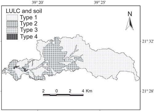
Calculation of the CN value was based on real values of land use, land cover and soil type. This information was obtained from satellite images and aerial photos for the area and then verified in the field. Land use and soil type were digitized and transferred to GIS software where they were superimposed over each other, as shown in , in order to calculate the percentages of each area (). It can be seen from that there are four types of land use and land cover in the area that correspond to four types of soil. The areal coverage percentages of these types (AP) are also shown along with their individual curve numbers (ICN). The calculated values of dry, normal and wet condition curve numbers are 69, 84 and 92, respectively, for which the runoff coefficient was calculated at 24, 52 and 74%. It was noticed that most rainfall losses take place at the beginning of the rainfall event and losses tend to become very little afterwards. The great losses at the beginning of the storm can be attributed to the high initial infiltration, while the low infiltration rate afterwards is due to the rocky nature and urbanization of the catchment. However, it should be noted that this storm took place during the rainy season after several days of cloudy sky, and thus the runoff coefficient for this event was quite high. For this reason, as well as the fact that most of the area is urban or suburban, the event simulation was performed for the wet condition only.
Table 5 Extracted data for CN calculation
Fig. 3 Distribution of LULC and soil types at Wadi Goase catchment.
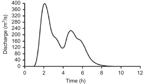
The most reasonably calculated time of concentration (tc
) from Equationequations (6)(6) and Equation(7)
(7) that reproduces the observed direct runoff depth was found to be about 1.6 h for Goase catchment under wet conditions; the derived hydrograph for the event is plotted in . In order to estimate the stage graph that might have been resulted from this flood, the calculated hydrograph was routed through the main wadi channel by utilizing HEC RAS. Results of these simulations under different scenarios are discussed below.
Fig. 4 Derived flood hydrographs for wet condition.
Calculation of flood water depth
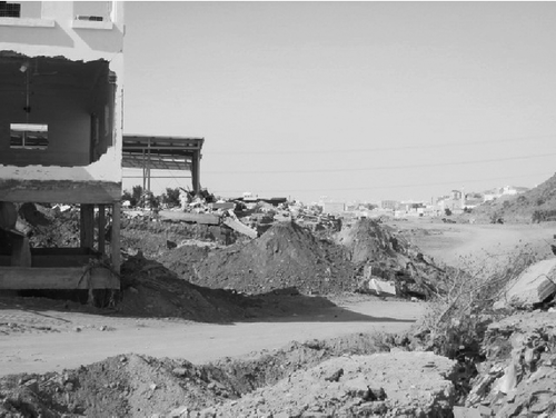
Intensive field investigations made it clear that the wadi main channel course was altered and blocked by many man-made levees at different locations. Local people build these levees either to divert flood water to their agricultural plots in rural areas, or to protect their properties in urban areas. The latter was the case in Wadi Goase, as there is no real interest in farming in this area, while interest in estate management is rather high and very profitable. However, most of the levees found in the catchment were too small and insignificant to influence a flood, apart from a major levee located about 4 km upstream of the town (). This levee was built in the main channel course in a very narrow area between two high mountains so that the water path was blocked (see ). It was about 7 m high and obstructed the flood path completely. According to local eye-witnesses, as soon as flood water reached this levee, it started to accumulate behind it; flood marks were left in this area above lamp posts, where debris was left hanging at heights of about 6 m. However, it did not take the water long to break the levee and burst through it, rapidly forming fast-moving, high waves, similar to a dam breach. The damage caused by this levee collapse is clearly seen in , seen from about 200 m downstream of the damaged road that had been constructed on the levee. The torrent of water formed a channel in the ground to a depth of about 3 m, excavating concrete building foundations and removing buildings without foundations entirely from their locations (). It was observed that the flood depth during the event reached the first-level balconies of buildings, exceeding 2 m in height.
Fig. 5 Demonstration of the damaging power of flood due to the levee breach.
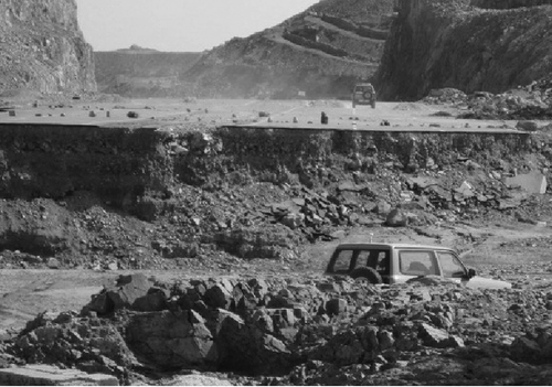
Fig. 6 Excavated building foundation following powerful flood damage due to levee breach.
In order to reconstruct the flood depth that took place in the streets of Gueeza town, the HEC RAS software was utilized to route the developed hydrograph. This task was carried out by surveying 12 cross-sections along the main channel, starting from about 1000 m upstream of the levee location and continuing all the way through the wadi channel to the streets of Gueeza. More cross-sections were automatically interpolated by the software, as shown in . Also, a levee was placed in the exact location in the simulated domain and the wadi longitudinal profile was established (see ) in order to simulate the effect of levee breach on the flow depth in the Gueeza streets. Thus, four scenarios were tested in these simulations:
Case 1: no levee breach; effect on the natural channel, Fig. 7 Wadi Goase—simulated cross-sections and longitudinal profile at the downstream location. 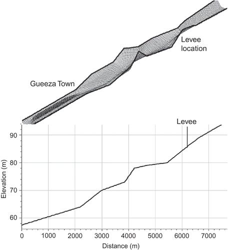 | |||||
Case 2: no levee breach; effect on the town streets, | |||||
Case 3: levee breach; effect on the natural channel, and | |||||
Case 4: levee breach effect; on the town streets. | |||||
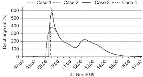
In the first and third scenarios, the calculated hydrograph was routed through the main wadi channel in its natural dimensions. However, in the second and fourth scenarios, the runoff hydrograph was routed through the main channel and then into five streets across the town, each of 15 m width, as observed in reality (see ). The resultant stage and flow graphs of the four scenarios are shown in and , respectively, and outputs values of the simulated parameters are shown in . It can be demonstrated from these figures that the worst results in terms of water depth were obtained as a result of the effect of levee breach on the town streets. This produced a water level in excess of 2 m which agrees well with observed stage that reached about 2.1 m in the narrow streets. The results are analysed in the next section.
Fig. 8 Main streets of Gueeza town.
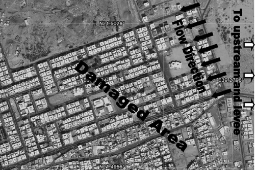
Fig. 9 Simulated stage graphs for the investigated four cases.
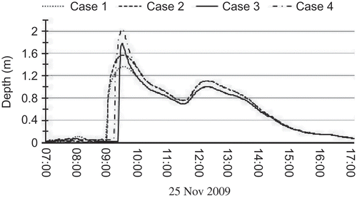
Fig. 10 Simulated discharge for the investigated four cases.
DISCUSSION AND CONCLUSIONS
To compensate for the absence of runoff gauging stations and proper rainfall data in the study area, a technique based on the curve number and dimensionless unit hydrograph was adopted in this study in order to reconstruct the characteristics of the flood that occurred in Gueeza town (Jeddah) on 25 November 2009. The robustness of the adopted technique was verified against recorded runoff events in another catchment, and this produced good results in spite of the low-quality data obtained for these tests. It was observed that the resulting water level in the town was extremely high (about 2.1 m) and the cause of this was not clearly addressed, although the levee breach that occurred during the flood was suspected. Therefore, the stage graph was reconstructed, routing the produced flood hydrograph through the main wadi channel and the town by utilizing HEC RAS software including routing hydrograph in natural channel conditions and flow conditions under the effect of dam breach. The influence of the levee breach upstream of Gueeza on the downstream wadi cross-sections, as well as on the town streets was investigated.
Table 6 Simulated parameter values for the simulated four case scenarios
It can be seen from the simulation results that the flow is a double peak phenomenon, with the first one occurring at about 09:30 h and the other at about 12:30 h (see and ). The timing of the peaks matches the field observations very well. Simulation results also show that the natural propagation of the flood hydrograph through the wadi channel results in a water level of 1.36 m near Gueeza town in Case 1 (). This level does not coincide with observed water level at Gueeza that exceeded 2 m. However, applying hydrograph routing through Gueeza streets resulted in an increase in water level of about 0.21 m (Case 2: water level of 1.57 m). This water level is still far below the observed level in the town during the flood. The discharge value was not affected by the effect of the town streets, although the flow maximum velocity increased from 2.9 (Case 1) to 3.3 m/s (Case 2; ). However, studying the effect of levee breach showed a significant effect on both the produced water level and discharge. In the natural channel, the water level rose to 1.78 m (Case 3), but it reached more than 2 m in the town streets (Case 4) due to the effect of levee breach. It can be seen that town streets had an effect on the water level (difference of 0.21 m), but that is not as significant as the effect of levee breach which produced a difference of 0.42 m. The highest water level occurred in Case 4 (2.03 m), which simulated the effects of both town streets and the levee breach; this was found to match very well the observed water level. It was found that the simulated flood stages for wet condition including the levee breach and town narrow streets compare very well with the observed flood stage in the street during this event. The levee breach also had a significant effect on the magnitude of discharge, which increased from 384 m3/s (Case 2) to 636 m3/s (Case 4) due to this effect. This resulted in an increase in flow velocity from 2.9 m/s (case 1) to about 3.8 m/s in the worst scenario (Case 4). The simulated high flow velocity reflects the great damaging potential of this flood and explains the devastating effect it had on the town. The effect of the levee breach on the water level in the town took place during the first peak only. The magnitude of the second peak had no significant effect, as the influence of the levee breach had almost diminished by the time the second peak started. Thus, the second peak may be attributed to natural phenomena.
Related Research Data
REFERENCES
- Aron , G. and Egborge , C.E. 1973 . A practical feasibility study of flood peak abatement in urban areas, Final report, Published by the Institute for Research on Land and Water Resources, March, 1973. ,
- Bahat , Y. 2009 . Rainfall–runoff modeling in a small hyper-arid catchment . Journal of Hydrology , 373 ( 1–2 ) : 204 – 217 .
- Bocchiola , D. and Rosso , R. 2009 . Use of a derived distribution approach for flood prediction in poorly gauged basins: A case study in Italy . Advances in Water Resources , 32 : 1284 – 1296 .
- Bracken , L.J. , Cox , N.J. and Shannon , J. 2008 . The relationship between rainfall inputs and flood generation in south-east Spain . Hydrological Processes , 22 ( 5 ) : 683 – 696 .
- Croke , B.F.W. 2006 . A technique for deriving an average event unit hydrograph from streamflow—only data for ephemeral quick-flow-dominant catchments . Advances in Water Resources , 29 ( 4 ) : 493 – 502 .
- El-Hames , A.S. and Richards , K.S. 1998 . An integrated, physically based model for arid region flash flood prediction capable of simulating dynamic transmission loss . Hydrological Processes , 12 ( 8 ) : 1219 – 1232 .
- Federal Aviation Administration, Department of Transportation . 1970 . Circular on airport drainage , Washington , DC : Federal Aviation Administration, Department of Transportation . Report A/C 050-5320-5B
- Foody , G.M. , Ghoneim , E.M. and Arnell , N.W. 2004 . Predicting locations sensitive to flash flooding in an arid environment . Journal of Hydrology , 292 ( 1–4 ) : 48 – 58 .
- Jothityangkoon , C. , Sivapalan , M. and Farmer , D.L. 2001 . Process controls of water balance variability in a large semi- arid catchment: downward approach to hydrological model development . Journal of Hydrology , 254 ( 1–4 ) : 174 – 198 .
- Kirpich , Z.P. 1940 . Time of concentration of small agriculture watersheds . Civil Engineering , 10 ( 6 ) : 362
- Lange, J., Leibundgut, C. and Schick, A.P., 1999. Recent techniques in large arid catchments—ways to overcome model calibration. In: Leibundgut, C., McDonnell, J.J. and Schultz, G., eds., Integrated methods in catchment hydrology, tracer, remote sensing and new hydrometric techniques. Wallingford, UK: IAHS Press, IAHS Publ. 258, 231–239. http://iahs.info/redbooks/a258/iahs_258_0231.pdf (http://iahs.info/redbooks/a258/iahs_258_0231.pdf)
- McIntyre , N. , Al-Qurashi , A. and Wheater , H. 2007 . Regression analysis of rainfall–runoff data from an arid catchment in Oman . Hydrological Sciences Journal , 52 ( 6 ) : 1103 – 1118 .
- Morin , E. , Jacoby , Y. , Navon , S. and Bet-Halachmi , E. 2009 . Towards flash-flood prediction in the dry Dead Sea region utilizing radar rainfall information . Advances in Water Resources , 32 : 1066 – 1076 .
- Rodriguez , F. , Andrieu , H. and Creutin , J.-D. 2003 . Surface runoff in urban catchments: morphological identification of unit hydrographs from urban databanks . Journal of Hydrology , 283 ( 1–4 ) : 146 – 168 .
- Sevinç , S. and Şen , Z. 2007 . Determination of flash floods in western Arabian Peninsula . Journal of Hydrologic Engineering , 12 ( 6 ) : 676 – 681 .
- Soil Conservation Service (SCS) . 1972 . Hydrology. Section 4, National engineering handbook , Washington , DC : US Department of Agriculture .
- US ACE (US Army Corps of Engineers) . 2009 . HEC-HMS, Hydrologic modeling system—user's manual, V. 3.4 , Davis , CA : US Army Corps of Engineers, Hydrologic Engineering Center .
- Vivoni , E.R. 2006 . Analysis of a monsoon flood event in an ephemeral tributary and its downstream hydrologic effects . Water Resources Research , 42 ( 3 ) : W03404