Abstract
The paper looks at two metrics of flood events: flood severity (related to flood frequency) and flood magnitude (related to flood severity, as above, but also to flood duration and affected area). A time series of flood information, over 25 years, collected by the Dartmouth Flood Observatory, is used to describe the spatio-temporal variability of large floods in Europe. Direct factors responsible for changes in flood severity and magnitude over time may be related to both climate and ground surface changes. Indirect links between flood severity/magnitude and socio-economic indices occur via flood risk reduction activities, land-use change and land-cover change. The present analysis shows an increasing trend during the 25-year period in the number of reported floods exceeding severity and magnitude thresholds.
Editor D. Koutsoyiannis
Citation Kundzewicz, Z.W., Pińskwar, I., and Brakenridge, G.R., 2013. Large floods in Europe, 1985–2009. Hydrological Sciences Journal, 58 (1), 1–7.
Résumé
Cet article se penche sur deux mesures des épisodes de crue, à savoir leur sévérité (liée à la fréquence des crues) et leur amplitude (liée à leur sévérité comme ci-dessus, mais aussi à leur durée et à l'étendue la zone affectée). Une série chronologique d'informations sur les crues de plus de 25 ans, recueillie par l'Observatoire des crues de Dartmouth, a été utilisée pour décrire la variabilité spatio-temporelle des crues importantes en Europe. Les facteurs directement responsables de l'évolution au cours du temps de la sévérité et de l'ampleur des crues peuvent être liés à la fois à des changements climatiques et à des modifications de la surface des sols. Des liens indirects entre la sévérité et l'ampleur des crues d'une part, et des indices socio-économiques d'autre part, se manifestent à travers les actions de réduction du risque d'inondation, ainsi que par des modifications de l'usage et de la couverture des sols. La présente analyse montre, au cours de la période étudiée, une tendance à l'augmentation du nombre de crues dont la sévérité et l'ampleur sont supérieures à divers seuils.
Key words:
INTRODUCTION
Floods attract broad interest and media coverage. Despite the massive risk reduction efforts and billions invested in flood defences worldwide, floods continue to be an acute problem, causing increasing material damage and high death tolls. The economic costs of extreme weather events (among which floods are a major category) have exhibited a rapid upward trend: yearly damage has increased globally by an order of magnitude within four decades, in inflation-adjusted monetary units (Mills Citation2005).
The causation of changes in flood risk may include socio-economic, surface environment and climatic changes. Flood risk can be intensified by humans, who—to use the language of mechanics—may increase the load and decrease the resistance of the system. Anthropogenic changes may have increased the flood magnitude for particular design precipitation events, and also have amplified the flood damage potential. Change in material flood loss can also be attributed to increasing damage potential, including the growing wealth accumulating in high flood-risk areas.
LARGE FLOODS IN EUROPE IN RECENT DECADES
Although the most dramatic extreme floods, with thousands of fatalities, occur outside Europe (in particular in South Asia), Europe is not immune. There have been several flood events with material damage in excess of €1 billion (euro), and the growing flood damage has intensified concern among European nations.
After the flood-rich decade of the 1990s, with many disastrous flood events in Europe, the 21st century has already witnessed several destructive floods.
Among the destructive floods in Europe in the 1990s were those in the basins of the River Rhine and its tributaries (1993, 1995), in the Mediterranean region (1994), and in Central Europe (1997). The flood on the Rhine in December 1993 caused inundation of parts of the cities of Koblenz, Bonn and Cologne, and then in January and February 1995 another large flood hit Germany, northern France, and The Netherlands. Dramatic floods devastated large areas in the Czech Republic, Poland and the Oder basin in Germany in July 1997.
Major floods occurred in the UK, Italy, France and Switzerland in the year 2000. The absolute record of annual flood loss in Europe was observed in August 2002, when the material damage exceeded €20 billion, in nominal value. This flood damaged the historical cities of Prague and Dresden. Major large floods also occurred in Europe in 2005, 2007 and 2010.
Several different global databases collect information on flood damage and are regularly updated. Flood-related entry records in such databases have multiple attributes, such as geographical information; date and duration of event; number of fatalities; economic damage; plus other information. Typically, economic damage is represented by “nominal” data in un-inflated US dollars ($). One of the databases is the Emergency Events Database (EM-DAT), run by the Centre for Research on the Epidemiology of Disasters (CRED) at the Catholic University of Leuven in Belgium. It was established in 1988 and collects information on floods as well as other natural disasters (http://www.emdat.be/). EM-DAT is primarily concentrated on humanitarian aspects. There are also two databases run by the major reinsurance companies, the NatCatSERVICE of Munich Re (https://www.munichre.com/touch/naturalhazards/en/natcatservice/default.aspx, set up in 1974), and the Sigma database of Swiss Re (http://www.swissre.com/sigma/ operating since 1970). These two databases, designed to serve the insurance industry, are focused on reliable and accurate estimation of material losses.
The quantitative assessment of flood losses is inevitably uncertain (see Choryński et al. Citation2012), hence one can only provide broad ranges of estimates of material damage. Indeed, compiling a list of the most destructive floods in a rigorous quantitative manner is a problematic task. Nevertheless, provides a sample, listing the six most destructive floods (in terms of material damage) in Europe, all of which occurred in the last 50 years.
Table 1 The six floods in Europe with the greatest (inflation-adjusted) material damage. See Choryński et al . (Citation2012) for sources of information
Another unique and useful, source of information on floods in recent decades is the Dartmouth Flood Observatory, which includes an “Active Archive of Large Flood Events, 1985–present”. Collection of these data has been carried out by G. R. Brakenridge and co-workers, first at Dartmouth College and then at the University of Colorado, both in the USA. This database differs from others in that it is dedicated to floods only, provides global coverage, and is matched to a large amount of satellite imagery of many of the events. The data are freely available from the Observatory's web site (http://floodobservatory.colorado.edu).
The Observatory uses both news reports and orbital remote sensing to detect floods, and it uses remote sensing in particular to measure and map surface water changes associated with identified inundation events. The event listing (the archive of “large” floods) provides a first-order characterization of all known events, from 1985 to the present. Now that more than 25 years of data are available, it is possible to examine changes in large flood characteristics (including severity and magnitude) in Europe for this time interval. Europe is a large geographic region; in fact rare events occur on individual river reaches (e.g. the 100-year flood at a gauging station) somewhere in Europe fairly frequently. Thus a large total number of events is available for study and analysis.
In order to compare individual flood events, and as part of standard flood reporting for the Observatory's Archive, Brakenridge proposed two indices characterizing floods—flood severity and flood magnitude (the latter being a function of flood severity, duration and inundated area). Three flood severity classes were defined as follows. Severity class 1 includes large flood events (often causing significant human and economic damage); with an estimated (commonly from news reports) mean return period (recurrence interval, or average interval between two events with magnitude equal to or greater than the level concerned) of the order of 10–20 years. Severity class 1.5 contains very large events whose return period is greater than 20 years but less than 100 years. Finally, severity class 2 includes truly extreme events, with an estimated return period (recurrence interval) equal to or greater than 100 years. Hence, severity is a discrete index, similar to the decimal logarithm of the mean return period (recurrence interval). It is not an exact descriptive statistic, but only an orientation method to allow use of expert judgments and also translation of news reports such as “largest flood in 50 years”, or “as large as the flood of 2002” into approximate numerical estimates of how unusual the flood discharge was.
Although severity, as defined above, is an important flood characteristic, it does not include other critical aspects of flooding. How widespread was the flood event? And how long did it last? Very widespread flooding persisting over long periods of time is a larger hydrological event than, for example, a severe flash flood that affects only one small drainage basin. Thus, a second statistic is needed, and “flood magnitude” is defined as:
The numbers of large floods above a certain magnitude threshold can be used to study changes over time. As defined, these metrics refer to floods as hydrological phenomena, not directly related to socio-economic effects. Severity is a measure of how rare or unusual the event is, while the magnitude of a rain-caused flood (depending on severity, duration of flood and its areal extent) may approximate the overall mass transfer of atmospheric water to the ground during the “event”, however such is defined.
A weak point of examining the overall number of floods above a certain magnitude threshold is that events adjacent to each other in time could be subjectively either grouped, as one event, or counted separately, as two. If treated together, they may constitute a super flood. If treated separately, they may constitute two smaller floods of lower magnitude. Decisions on treating adjacent events should be made as objectively as possible, but even separation of adjacent flood discharge hydrographs can be difficult when analysing streamflow records. Fortunately, the news-based source of much of the Flood Observatory Archive information commonly creates natural boundaries around events: damaging, rare flooding attracts abundant news reports, which follow the event as it increases to maximum severity and extent, and the daily news coverage declines as the flood wave begins to recede. Then two alternatives occur: (a) a new input of water initiates new flooding and media coverage, even while the previous event is still being reported, or (b) media attention drops to zero or very near zero, soon after which a new event is reported. These alternatives provide a useful guide to the heuristic “lump or split” decision. Note also that flooding commonly occurs upstream first and then moves downstream. The event begins at upstream locations, and extends through time until flooding has receded at even the downstream locations.
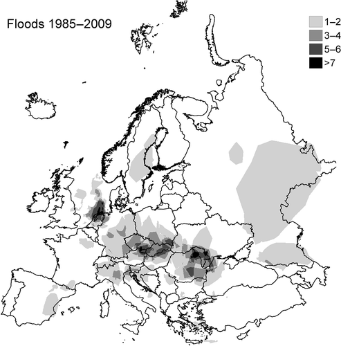
Pińskwar et al. (Citation2012) compiled counts of large floods in consecutive 5-year intervals and presented orientation maps of changing numbers of large floods in such intervals for Europe. illustrates the spatial distribution of the number of large floods (for which severity is greater than or equal to 1.5), in Europe, over the entire 25-year time interval, 1985–2009, for which records are available in the Flood Observatory database. In the period 1985–2009, some areas of Europe were visited by up to nine large floods. The countries with multiple large floods during 1985–2009 are: Romania, Czech Republic, Slovak Republic, UK, Germany and Austria (), of which Romania was affected most frequently.
Fig. 1 Spatial distribution of the number of large floods in Europe, based on records of the Flood Observatory over the entire 25-year time interval, 1985–2009, for which records are available (cf. Pińskwar et al. Citation2012). The threshold for classification of large floods is severity equal to or larger than 1.5.
ARE EUROPEAN RIVER FLOW REGIMES CHANGING?
Over the last 50 years, heavy precipitation events have been increasing in frequency over most extra-tropical regions, at the continental and global scales (cf. Groisman et al. Citation2005, Trenberth et al. Citation2007). This includes widespread increases in the contribution to total annual precipitation from very wet days (days in which precipitation amounts exceed the 95th percentile value) in many land regions. This corresponds to an observed significant increase in water vapour amount in the warmer atmosphere. However, the rainfall statistics are strongly influenced by inter-annual and inter-decadal variability. There are problems with data availability in general, and also with data homogeneity and accuracy. As noted by Zolina (Citation2012), intense precipitation in Europe exhibits complex variability and lacks a robust spatial pattern. The changes in heavy precipitation are inconsistent across studies, and are region- and season-specific. However, the dominating tendency (for many regions, using several indices) is that heavy precipitation has been increasing. In many regions (e.g. central-western Europe and European Russia), increasing trends in high percentiles of daily winter precipitation were found, but in some regions trends were decreasing. Also, the structure of precipitation has changed—a larger fraction of total precipitation comes in the form of prolonged wet spells as opposed to shorter rain events. As stated by Zolina (Citation2012) short, isolated rain events have been regrouped into prolonged wet spells. We note that the assumption of “stationarity” in streamflow records, upon which traditional flood risk evaluation is based, conflicts with the results of such studies. Thus, one cannot assume that flood frequency and magnitude statistics have remained or will remain unvarying over time (Milly et al. Citation2008).
There have been several attempts to seek robust trends in European high river discharges, but the results so far are not conclusive. The results of a global change detection study of annual maximum river flows (Kundzewicz et al. Citation2005, Svensson et al. Citation2005) do not support the hypothesis of a ubiquitous increase in annual maximum river flows. There are also many other aspects of potential non-stationarity: for example, Lins and Slack (Citation1999) describe streamflow trends in the conterminous USA as “getting wetter but less extreme”.
According to Wilby et al. (Citation2008), detection of persisting climate change even at global or regional scales is inherently difficult because of the low signal-to-noise ratio. The climate change signal is superimposed on a strong inter-annual and interdecadal variability in both rainfall and river discharge (the latter of which is further affected by land-use change and river regulation). Hence, Wilby et al. (Citation2008) speculate that statistically robust trends are unlikely to be found for several decades even if change is occurring.
The controversy regarding the question of whether or not floods have been more frequent is especially apparent in the context of future flood risk. Several model scenarios of future climate indicate a likelihood of increased intense precipitation and flood hazard, with more severe hydrological extremes being associated with a warmer climate (cf. Kundzewicz et al. Citation2008). On the grounds of physics (Clausius-Clapeyron law), there is indeed enhanced potential for intense precipitation in the warmer atmosphere (cf. Trenberth Citation1999, Trenberth et al. 2007). Several researchers, such as Palmer and Räisänen (Citation2002) and Christensen and Christensen (Citation2003), report projections of more intense precipitation with consequences for flooding in the future, warmer climate. Model-based projections for the future (e.g. Milly et al. Citation2002, Lehner et al. Citation2006, Dankers and Feyen Citation2008, Hirabayashi et al. Citation2008) show a clear increase in flood hazard over large areas. There is a lack of agreement, however, between the results of observations from the past to the present, and the results of model projections for the future. The former show no ubiquitous upward trend in flood maxima, while the latter do predict upward changes. The failure to detect a ubiquitous rising trend in floods has been a surprise to some experts describing recent flood events as possible harbingers of a rise in flood risk related to climate change. This is exemplified by Schiermeier (Citation2003): “Analysis pours cold water on flood theory”, an article referring to negative results of trend detection by Mudelsee et al. (Citation2003).
Despite the above, a regional change in the timing and nature of floods has been observed in many areas of Europe. For instance, less frequent snowmelt and ice-jam related floods have been recorded, cf. Kundzewicz (Citation2002, p. 237): “It was reported from much of Europe that ... less snow cover may reduce the severity of spring snowmelt floods ... It seems that, where the rivers freeze, milder winters lead generally to thinner ice cover and shorter persistence and reduce severity of ice jams. Ice-jam related floods are not a major problem anymore in much of Europe, where the rivers freeze less often in the warming climate (with industrial waste heat playing also a role in many locations).” Mudelsee et al. (Citation2003) found significant downward trends in floods during winter (November–April) in two major rivers (Elbe and Oder) in Central Europe.
TEMPORAL CHANGES IN LARGE FLOOD FREQUENCY
The availability of 25 years of large flood records in the Dartmouth Flood Observatory Archive allows analysis of the time series of flood indices over the continent. Examining the material available, one can analyse the temporal changes of numbers of floods above fixed thresholds of severity or magnitude. illustrates the numbers of large floods in each individual year since 1985. Two definitions of “large floods” are considered here: (a) flood events whose severity is greater than or equal to 1.5, and (b) those whose magnitude is greater than or equal to 5.
Fig. 2 Numbers of large floods of severity ≥1.5 and/or magnitude ≥5 in Europe each year during 1985–2009, based on Dartmouth Flood Observatory records.
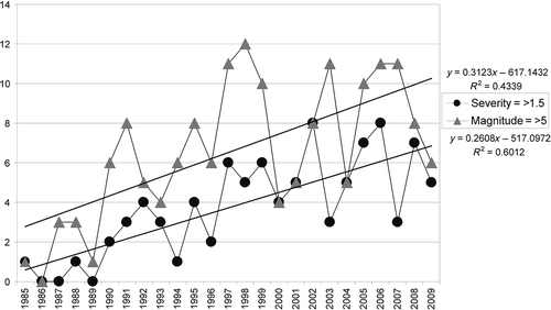
Figure 2 clearly demonstrates that, for both definitions of large floods, according to available records, the numbers of large flood events during the 25-year period 1985–2009, increased.
However, notwithstanding the clear rising trends, considerable variability is superimposed. For example, in the flood-rich years 1997 and 1998, the number of large floods (magnitude ≥5) in Europe equalled 11 and 12, respectively, while in a flood-poor year, such as 2000, this number was only 4. Also, much caution is needed in inferring long-term changes, because the series is not entirely homogeneous: it is possible that less media-based information was available in the early days of the database, 1985–1989. Other workers and the Flood Observatory archival reference information also discuss this likely bias. However, most large events do trigger a considerable number of media reports. Even if some events may still have been missed, particularly early in the record, due to the high cut-off threshold, most severe and high-magnitude events in each year are likely to have entered the archive.
CONCLUDING REMARKS
Time series of large flood event information collected in the Dartmouth Flood Observatory records provide one data source for illustrating their spatio-temporal variability. The sample of 25 annual numbers is small in a statistical sense (when used to describe event patterning whose recurrence intervals may exceed 100 years), yet it offers useful insight. It will be instructive to look into future years of record to examine what trend the extending time series follows.
Although many studies of longer time series of flood records have recently been reported for limited areas of Europe, e.g. Lindström and Bergström (Citation2004), Macdonald and Black (Citation2010), Brázdil et al. (Citation2011a, Citation2011b), Hänggi and Weingartner (Citation2011), Villarini et al. (Citation2011), and Wetter et al. (Citation2011), and for much of North America (Villarini et al. Citation2009, Hirsch and Ryberg Citation2012), they do not cover the flood metrics considered in the present paper. Moreover, long time series (observations cum historical data) present a range of problems too. The advantage of the approach used here, harnessing the Dartmouth Flood Observatory records, is a broad spatial coverage of the European continent.
This paper looks at two indices of flood events: flood severity (related to flood frequency) and flood magnitude (related to flood severity, duration and inundated area). Direct factors responsible for changes in flood severity and magnitude could result from climate change, but watershed surface changes and river engineering can also play a role. There is no direct link to socio-economic characteristics such as material damage potential, or monetary damage amount, whose reason for increase with time is well known, cf. anthropopressure and human encroachment into unsafe areas (Di Baldassare et al. Citation2010, Koutsoyiannis Citation2011). Only indirect links between flood severity/magnitude and socio-economic indices can be envisaged, via flood-risk reduction activities, land-use change and land-cover change.
A robust and ubiquitous trend in maximum river flow, or any other geophysical flood indicator has not yet been found in the available literature. Hence, the rationale for the present analysis, where an increasing trend seems to be suggested by the number of reported floods exceeding defined thresholds of two flood metrics.
Acknowledgements
The contributions of ZWK and IP were supported by the project PSPB no. 153/2010, FLOod RISk on the northern foothills of the Tatra Mountains (FLORIST), supported by a grant from Switzerland through the Swiss Contribution to the enlarged European Union. The authors acknowledge the constructive remarks by two anonymous referees, one eponymous referee—Dr Giuliano Di Baldassare—and Professor Demetris Koutsoyiannis, Co-Editor of HSJ, that helped to improve the paper.
REFERENCES
- Brázdil , R. 2011a . Fluctuations of floods of the River Morava (Czech Republic) in the 1691–2009 period: interactions of natural and anthropogenic factors . Hydrological Sciences Journal , 57 ( 1 ) : 468 – 485 .
- Brázdil , R . 2011b . Floods and floodplain changes of the River Morava, the Strážnické Pomoraví region (Czech Republic) over the past 130 years . Hydrological Sciences Journal , 56 ( 7 ) : 1166 – 1185 .
- Choryński , A. 2012 . “ Catalogue of large floods in Europe in the 20th century ” . In Changes in flood risk in Europe , Edited by: Kundzewicz , Z.W. Vol. 10 , 27 – 54 . Wallingford : IAHS Press and CRC Press/Balkema (Taylor & Francis Group)IAHS Special Publ .
- Christensen , J.H. and Christensen , O.B. 2003 . Severe summertime flooding in Europe . Nature , 421 : 805 – 806 .
- Dankers , R. and Feyen , L. 2008 . Climate change impact on flood hazard in Europe: an assessment based on high resolution climate simulations . Journal of Geophysical Research , doi: 10.1029/2007JD009719
- Di Baldassarre , G. 2010 . Flood fatalities in Africa: from diagnosis to mitigation . Geophysical Research Letters , doi: 10.1029/2010GL045444
- Groisman , P.Y. 2005 . Trends in intense precipitation in the climate record . Journal of Climate , 18 : 1326 – 1350 .
- Hänggi , P. and Weingartner , R. 2011 . Inter-annual variability of runoff and climate within the Upper Rhine River basin, 1808–2007 . Hydrological Sciences Journal , 56 ( 1 ) : 34 – 50 .
- Hirabayashi , Y. 2008 . Global projections of changing risks of floods and droughts in a changing climate . Hydrological Sciences Journal , 53 ( 4 ) : 754 – 773 .
- Hirsch , R.M. and Ryberg , K.R. 2012 . Has the magnitude of floods across the USA changed with global CO2 levels? . Hydrological Sciences Journal , 57 ( 1 ) : 1 – 9 .
- Koutsoyiannis , D. 2011 . Scale of water resources development and sustainability: small is beautiful, large is great . Hydrological Sciences Journal, Special issue Water crisis: From conflict to cooperation , 56 ( 4 ) : 553 – 575 .
- Kundzewicz , Z.W. 2002 . “ Floods in the context of climate change and variability ” . In Climate change: Implication for the hydrological cycle and for water management , Edited by: Beniston , M. 225 – 247 . Dordrecht : Kluwer .
- Kundzewicz , Z.W. 2012 . Changes in flood risk in Europe , Vol. 10 , Wallingford : IAHS Press and CRC Press/Balkema (Taylor & Francis Group)IAHS Special Pub .
- Kundzewicz , Z.W. 2005 . Trend detection in river flow series: 1. Annual maximum flow . Hydrological Sciences Journal , 50 ( 5 ) : 797 – 810 .
- Kundzewicz , Z.W. 2008 . The implications of projected climate change for freshwater resources and their management . Hydrological Sciences Journal , 53 ( 1 ) : 3 – 10 .
- Lehner , B. 2006 . Estimating the impact of global change on flood and drought risks in Europe: a continental, integrated assessment . Climatic Change , 75 : 273 – 299 .
- Lindström , G. and Bergström , S. 2004 . Runoff trends in Sweden 1807–2002 . Hydrological Sciences Journal , 49 ( 1 ) : 69 – 83 .
- Lins , H.F. and Slack , J.R. 1999 . Streamflow trends in the United States . Geophysical Research Letters , 26 ( 2 ) : 227 – 230 .
- Macdonald , N. and Black , A.R. 2010 . Reassessment of flood frequency using historical information for the River Ouse at York, UK (1200–2000) . Hydrological Sciences Journal , 55 ( 7 ) : 1152 – 1162 .
- Mills , E. 2005 . Insurance in a climate of change . Science , 309 : 1040 – 1044 .
- Milly , P.C.D. 2002 . Increasing risk of great floods in a changing climate . Nature , 415 : 514 – 517 .
- Milly , P.C.D. 2008 . Stationarity is dead: whither water management? . Science , 319 : 573 – 574 .
- Mudelsee , M. 2003 . No upward trends in the occurrence of extreme floods in Central Europe . Nature , 421 : 166 – 169 .
- Palmer , T.N. and Räisänen , J. 2002 . Quantifying the risk of extreme seasonal precipitation events in a changing climate . Nature , 415 : 512 – 514 .
- Pińskwar , I. 2012 . “ Changing floods in Europe ” . In Changes in flood risk in Europe , Edited by: Kundzewicz , Z.W. Vol. 10 , 83 – 96 . Wallingford : IAHS Press and CRC Press/Balkema (Taylor & Francis Group), IAHS Special Pub .
- Schiermeier , Q. 2003 . Analysis pours cold water on flood theory . Nature , 425 : 111
- Svensson , C. , Kundzewicz , Z.W. and Maurer , T. 2005 . Trend detection in river flow series: 2. Flood and low-flow index series . Hydrological Sciences Journal , 50 ( 5 ) : 811 – 824 .
- Trenberth , K.E. 1999 . Conceptual framework for changes of extremes of the hydrological cycle with climate change . Climatic Change , 42 : 327 – 339 .
- Trenberth, K.E., et al., 2007. Observations: Surface and atmospheric climate change. In: S.D. Solomon, et al., eds. Climate change 2007: The physical science basis. Contribution of Working Group I to the Fourth Assessment Report of the Intergovernmental Panel on Climate Change. Cambridge: Cambridge University Press http://www.ipcc.ch/pdf/assessment-report/ar4/wg1/ar4-wg1-chapter3.pdf (http://www.ipcc.ch/pdf/assessment-report/ar4/wg1/ar4-wg1-chapter3.pdf)
- Villarini , G. 2009 . On the stationarity of annual flood peaks in the continental United States during the 20th century . Water Resources Research , 45 : W08417 doi: 10.1029/2008WR007645
- Villarini , G. 2011 . Hydrometeorological analysis of the December 2008 flood in Rome . Hydrological Sciences Journal , 56 ( 7 ) : 1150 – 1165 .
- Wetter , W. 2011 . The largest floods in the High Rhine basin since 1268 assessed from documentary and instrumental evidence . Hydrological Sciences Journal , 56 ( 5 ) : 733 – 758 .
- Wilby , R.L. , Beven , K.J. and Reynard , N.S. 2008 . Climate change and fluvial risk in the UK: more of the same? . Hydrological Processes , 22 : 2511 – 2523 .
- Zolina , O. 2012 . “ Change in intense precipitation in Europe ” . In Changes in flood risk in Europe , Edited by: Kundzewicz , Z.W. Vol. 10 , 97 – 120 . Wallingford : IAHS Press and CRC Press/Balkema (Taylor & Francis Group) IAHS Special Pub .