Abstract
Large-scale agricultural activities cause deterioration of groundwater resources throughout the world. This study focuses on the irrigated agricultural district of Jinghuiqu in Shaanxi, China. The objectives are to identify the main sources and processes that control nitrate transport, and to assess the impact of long-term irrigation practices on nitrate leaching. The hydrogeochemistry of major solute constituents and stable isotope ratios of NO3 − in groundwater were used to identify historical sources of contamination and transformation processes occurring in the shallow groundwater of the Jinghuiqu irrigation district. The N-NO3 − concentrations in groundwater ranged from 0.0 to more than 100 mg L−1 in April 1990, and from 0.47 to 42.0 mg L−1 in December 2009. Our measurements of N-NO3 − show that the main reasons for this dramatic decline in N-NO3 − concentrations from 1990 to 2009 are denitrification, which controls nitrogen types, together with the sharp decline of the groundwater table. The isotope ratios in collected samples showed that the source of nitrate was mainly manure, a result that corresponds with historical data showing that manure was the main nitrate source before the 1980s, and that fertilizers became dominant thereafter. A numerical model was then used to evaluate future impacts of current irrigation practices on groundwater sources. The HYDRUS-1D model was employed first to evaluate the water movement and the N-NO3 − solute transport for a single irrigation pulse experiment carried out under field conditions, and then in evaluating the long-term impact of irrigation on N-NO3 − leaching. Simulations showed that, after introducing irrigation, the downward drainage fluxes of N-NO3 −, and the N-NO3 − and N-tot concentrations increased at all depths within the 2-m soil profile. This indicates that N concentrations below 1-m depth and in the groundwater could become even more elevated with increased future irrigation.
Editor D. Koutsoyiannis
Citation Liu, X.-H., Sun, S.-J., Ji, P., and Šimůnek, J., 2013. Evaluation of historical nitrate sources in groundwater and impact of current irrigation practices on groundwater quality. Hydrological Sciences Journal, 58 (1), 1–15.
Résumé
Les activités agricoles à grande échelle entraînent une détérioration des ressources en eaux souterraines à travers le monde. Cette étude se concentre sur le district agricole irrigué de Jinghuiqu dans le Shaanxi, en Chine. Les objectifs sont d'identifier les principales sources et les processus qui contrôlent le transport des nitrates, et d'évaluer l'impact des pratiques d'irrigation à long terme sur le lessivage des nitrates. L'hydrogéochimie des principaux constituants du soluté et les ratios des isotopes stables de NO3 − dans les eaux souterraines ont été utilisés pour identifier les sources historiques de contamination et les processus de transformation qui se produisent dans les eaux souterraines peu profondes du district d'irrigation de Jinghuiqu. Les concentrations en N-NO3 − dans les eaux souterraines variaient de 0,0 à plus de 100 mg L−1 en avril 1990, et de 0,47 à 42.0 mg L−1 en décembre 2009. Nos mesures de N-NO3 − montrent que les principales raisons de cette baisse spectaculaire des concentrations en N-NO3 − de 1990 à 2009 sont la dénitrification, qui contrôle les types d'azote, ainsi que la forte baisse de la nappe phréatique. Les rapports des isotopes dans les échantillons prélevés ont montré que la source de nitrate était principalement le fumier, ce qui correspond bien avec les données historiques indiquant que le fumier était la principale source de nitrate avant les années 1980, et que les engrais sont devenus dominants par la suite. Un modèle numérique a ensuite été utilisé pour évaluer les impacts futurs des pratiques d'irrigation actuelles sur les ressources d'eau souterraine. Le modèle HYDRUS-1D a été utilisé d'abord pour évaluer le mouvement de l'eau et le transport de solutés N-NO3 − lors d'une expérience d'impulsion unique d'irrigation réalisée dans des conditions de terrain, puis pour évaluer l'impact à long terme de l'irrigation sur le lessivage de N-NO3 −. Les simulations ont montré que, après l'introduction de l'irrigation, les flux de N-NO3 − dans le drainage vertical et les concentrations en N-tot ont augmenté à toutes les profondeurs dans le profil du sol à 2 m. Cela indique que les concentrations en azote à la fois en dessous de la profondeur de 100 cm et dans les eaux souterraines pourraient devenir encore plus élevées avec l'augmentation future de l'irrigation.
Citation Liu, X.-H., Sun, S.-J., Ji, P., and Šimůnek, J., 2013. Evaluation of historical nitrate sources in groundwater and impact of current irrigation practices on groundwater quality. Hydrological Sciences Journal, 58 (1), 1–15.
1 INTRODUCTION
Groundwater pollution is one of the most important and widespread environmental problems in irrigated agricultural regions (Aber et al. Citation2003, Galloway et al. Citation2008). Inappropriate management of groundwater promotes the rapid deterioration of water quality, exposing human and animal communities to health and survival risks. Among various other sources of contamination, irrigation and other agricultural activities exert direct and indirect effects on the rates and compositions of groundwater recharge and aquifer biogeochemistry (Böhlke Citation2002). Due to the increase of anthropogenic nitrogen inputs at many watersheds (e.g. Boyer et al. Citation2002, Vassiljev et al. Citation2004), NO3 − contamination constitutes an increasing problem in many shallow groundwater systems underneath agricultural areas (Geake and Foster Citation1989, Arumi et al. Citation2005). Elevated levels of nitrate in drinking water can cause serious health problems (Wolfe and Patz Citation2002, Kaown et al. Citation2009).
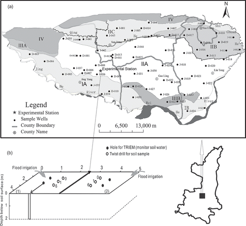
The present work describes a study that was undertaken in the Jinghuiqu Irrigation District (JID), located in Shaanxi Province, China ((a)). This district has 2200 years of irrigation history. The surface flooding method is used for irrigation. Each time, the irrigation quantity is about 180 to 240 mm depth of water. Fertilizers are commonly applied during each irrigation event.
Fig. 1 (a) Map of the Jinghuiqu Irrigation District (Shaanxi province, China) and location of groundwater sampling wells. Shading and symbols represent different hydrogeological conditions—IA: the Jinghe River first terrace strong water-rich sub-district; IIA: the Jinghe River second terrace water-rich sub-district (south of Yeyuhe and Qihe rivers); IIIA: the Jinghe River third terrace water-rich sub-district; IB: the Weihe River first terrace strong water-rich sub-district; IIB: the Jinghe River second terrace water-rich sub-district (north of Qihe River); IIIB: the Weihe River second terrace water-rich sub-district; IIC: the Jinghe River second terrace water-rich sub-district (north of Yeyuhe and Qihe rivers); IV: the Loess Plateau weak water-rich sub-district. (b) Experimental arrangement: x-, y- and z-axes (in m). Plot 1 was irrigated only with groundwater, while Plot 2 was irrigated with groundwater and fertilizer ((NH4)2HPO4). The numbers 0, 1, and 6 in the plots indicate the sampling times (at the beginning of the experiment, and 1 and 6 days after irrigation) using a twist drill.
Located in an arid and semi-arid region, the Jinghuiqu district has a shortage of water resources for irrigation. So far, existing research has focused mainly on quantitative water-related issues, such as the irrigation system (Li Citation1998, Liu Citation2002), irrigation techniques (Gao Citation2004), optimization of water resources, efficient use of irrigation water, and optimal conjunctive use of surface and groundwater (Li et al. Citation1999, Liu Citation2005, Zhao and Fei Citation2006, Liu and Zhu Citation2011). Since 1990, due to the lack of available surface water, the Jinghuiqu district has increased pumping from the aquifers in order to provide water for irrigation, which has resulted in a significant drop in the groundwater table (Liu Yan Citation2010). However, research is still lacking on water quality-related issues, such as the evolution of nitrogen concentrations.
Our field survey showed that the groundwater has become seriously polluted with nitrogen. Flood irrigation, the current irrigation practice, may have caused an increase in nitrogen leaching and compounded the risks of groundwater pollution. Importantly, the groundwater in this area is not only the major source of water for industry and agriculture, but also of drinking water for the local people. Thus, establishing a sound irrigation policy and reducing manure applications may be options to mitigate these risks. Such a policy must be based on the identification of the sources of pollution, and on a quantitative analysis of the subsurface movement of water and dissolved chemicals. Numerical modelling of subsurface water flow and nitrate transport will be essential for predicting groundwater quality for irrigation, implementing better irrigation and fertilization practices, and quantifying pollution hazards.
The objectives of this study were: (a) to identify historical NO3 − sources and the controlling hydrogeochemical processes in the groundwater by using stable isotopes and analysing spatial and temporal variations of nitrate in the groundwater of the entire irrigation area, and (b) to quantify the impacts of long-term flood irrigation practices on N leaching into the groundwater in the JID using an irrigation lysimeter experiment. While objective (a) was addressed by analysing groundwater samples collected from 205 wells, objective (b) was achieved by evaluating lysimeter data using the HYDRUS-1D software package (Šimůnek et al. Citation2008) and then extending HYDRUS-1D numerical simulations over a period of several years. The lysimeter experiment was intended to replicate current irrigation and fertilizer conditions in order to determine whether or not the elevated N in the groundwater is controlled by the long-term flood irrigation.
2 MATERIALS AND METHODS
2.1 Experimental site and collected data
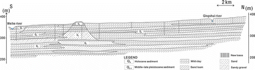
Jinghuiqu (34°25′20″–34°41′40″N, 108°34′34″–109°21′35″E) is a large irrigation district located in the middle of the Guanzhong Plain of Shaanxi Province () with a total area of 1180 km2. It belongs to the catchment of the Weihe River, a Cenozoic fault-block basin filled predominantly with Tertiary fluvial and aeolian sediments and Quaternary loess (Bellier et al. Citation1988). The upper part of the sedimentary fill consists mainly of Quaternary fluvial deposits (), having mostly a sandy clay loam texture with a bulk density averaging about 1.4 g cm−3 ().
Table 1 Selected physical and chemical soil characteristics for experimental Plot 2
Fig. 2 Cross-section of the Jinghuiqu Irrigation District, and locations and depths of sampling wells.
The Jinghuiqu area has a 2200-year history of irrigation, initially with only surface water from the Jinghe River, but now both surface water and groundwater are used. The climate is semi-arid and has a mean annual precipitation of about 533 mm, with nearly 60% of the annual rainfall received between July and September. The average annual potential evapotranspiration is 1212 mm. While winter wheat and maize are generally irrigated using water from the aquifer between June and September, surface water is typically used between November and May in order to preserve the groundwater table. The total irrigation is about 500 mm per year.
2.1.1 Groundwater quality analysis
Groundwater samples for chemical and isotopic analyses were collected in April 1990 (91 wells), November 2008 (69 wells) and December 2009 (46 wells) in the JID from both shallow and deep (extending to >50 m below the surface) wells used for domestic and agricultural water supply. Sampling locations are shown in (a). Although the same sampling locations were used in different years, as groundwater levels had fallen since 1990, by 2008/09 several wells' screens were above the groundwater table and the wells could not be used for the next sampling round. Groundwater samples were collected directly from the taps of the domestic wells, and with a submersible pump in the monitoring wells. Groundwater samples were collected over three days, filtered through a 0.45-mm membrane, and stored in 60 mL polyethylene bottles for chemical analysis. Samples for cation analysis were preserved using ultra-pure HNO3. Cations were analysed using inductively coupled plasma-atomic emission spectrometry (ICP-AES); anions were analysed using ion chromatography. N-NH4 + was determined using a modified Bertholot method (Searle Citation1984); N-NO3 − was measured using an automated segmented flow analyser with the cadmium reduction method to quantify N-NO3 − (Hendrilsen and Selmer-Olsen Citation1970). The pH was measured using a potentiometric method.
Ten groundwater samples, collected in November 2008 (see ), were selected for an analysis of δ15N values of NO3 − in the State Key Laboratory of Environmental Geochemistry at the Institute of Geochemistry, Guiyang. The nitrate was extracted, converted to AgNO3, and analysed for its isotope composition. Nitrate was eluted from the anion exchange columns using 15 mL of 3M HCl. The nitrate-bearing acid eluant was neutralized using Ag2O, filtered to remove the AgCl precipitate, and freeze-dried to obtain solid AgNO3, which was then combusted to N2 in sealed quartz tubes for the δ15N analysis (Kendall and Grim Citation1990). The analytical precision for δ15N was ±0.05‰.
Table 2 Measured NO3 − concentrations and isotope values for groundwater wells located in the irrigation district
2.1.2 Field experiments
Field infiltration processes were studied in the soil profile irrigated with groundwater at the experimental station of the Jinghuiqu irrigation area ((b)). Two experimental plots (each 11 m2 by 2.0 m deep) were constructed. The plots were laterally isolated with mounds to prevent lateral movement of surface water (and form lysimeters), and were exposed to atmospheric conditions. They were bare (not covered by vegetation) during the experiments. During the normal irrigation period in November 2008, they were manually flood-irrigated with a quantity of 180 mm (nearly 2 m3) of applied groundwater.
Groundwater used for irrigation was monitored for concentrations of Na+, Ca2+, Mg2+, SO4 2-, N-NH4 +, and N-NO3 − (). Chemical fertilizer ((NH4)2HPO4) was dissolved in water before irrigation, but after the water analysis reported in .
Table 3 Ionic composition of irrigation waters used in the field experiment and HYDRUS simulations (mmol L−1)
At the beginning of the experiment, and at one and six days after irrigation, soil samples were collected using a twist drill from depths of 0–20, 20–40, 40–60, 60–100, 100–150, and 150–200 cm (mixed samples were used; e.g. the 0–20 cm soil sample was mixed from soil collected between depths of 0 and 20 cm). Samples were stored in a dark chamber and kept at 4°C until laboratory measurements the next day. All measurements were performed with three replicates of each soil sample. Soil samples were mixed with water (1:5 soil/solution) for the measurement of NO3 −, Cl−, SO4 2‐, HCO3 −, Na+, K+, Ca2+ and Mg2+.
The TDR system with Intelligent Micromodule Elements (TRIME) (IMKO, Germany) was used to measure water contents in the vadose zone before irrigation, and at one and five days after irrigation, at 20-cm intervals between depths of 0.2 and 2 m. The TRIME portable borehole packer unit used here has a two-electrode probe configuration, with 150-mm-long electrodes made from lead. The packer is lowered into a 100-mm diameter, uncased borehole and then inflated to push the electrodes close to the borehole wall according to the method described by West and Truss (Citation2006). The borehole was cased to 2 m depth with a polyethylene pipe to prevent its collapse. Two readings were taken at each depth and averaged; however, these readings rarely differed by more than 0.2%. Removing the packer and re-inflating it at the same depth produced readings that were repeatable within 0.5%. The manufacturer's calibration was used, which converts the measured travel time of a signal directly into the water content of the material in contact with the packer.
2.2 Data analysis
The HYDRUS-1D model (Šimůnek et al. Citation2008) was used in our analysis. This model has been extensively used in simulating water and contaminant transport in variably-saturated porous media (Jiang et al. Citation2010), and for a wide range of applications in both the research and management of irrigation systems with poor water quality (e.g. Gonçalves et al. Citation2006, Hanson et al. Citation2008, Forkutsa et al. Citation2009, Šimůnek et al. Citation2009). The model has also been used to evaluate the fate of nutrients in soils, to compare different fertilization strategies (e.g. Gärdenäs et al. Citation2005, Hanson et al. Citation2006, Ajdary et al. Citation2007, Crevoisier et al. Citation2008, Michel et al. Citation2010), and to simulate nitrogen transport and transformations under transient water flow conditions involving plant uptake, nitrification, denitrification, immobilization, mineralization and ionic exchange (Hanson et al. Citation2006, Rozemeijer et al. Citation2009). HYDRUS-1D is widely considered to be a reliable tool for analysing water flow and the fate of various solutes in the subsurface.
In this study, we used HYDRUS-1D to evaluate data collected at the experimental field plots and to assess the long-term impact of current irrigation and fertilizer practices on groundwater in the JID. In order to better assess the impact of N movement and how long it would take for N to reach the groundwater under current fertilization and irrigation conditions, we chose an evaluation period of five years. Daily rainfall and evapotranspiration rates were used as the upper boundary condition, and one-year's data was repeated five times.
The fields of the JID are usually irrigated three to five times a year, depending on precipitation, and irrigation quantity is always 180–240 mm each time. In our simulations, irrigations were applied three times each year: on 1 April (using surface water for winter wheat), 1 August (using groundwater for the maize), and 1 November (again using surface water for winter wheat), to represent typical irrigation times. At each time, the irrigation amount was 180 mm, and the quantity of fertilizer was approx. 10.23 g m−2 ((NH4)2HPO4), based on the current irrigation and fertilization practices. The same soil profile was used as for the field experiment described above, except that the simulated depth was 10 m. The soil's physical characteristics and hydraulic functions were also the same as shown in Tables 1 and 4, with the soil properties at 2 m depth extended down to the bottom of the soil profile. Irrigation water quality is given in . It was assumed that the crops take up 70% of the fertilizer, while the remaining 30% is leached into the soil (Olson and Swallow Citation1984, Prins et al. Citation1998, Liu and Wu Citation2003).
2.2.1 Water flow
Variably-saturated water flow was simulated in HYDRUS-1D using the Richards equation, which requires input parameters describing the soil hydraulic properties. The van Genuchten-Mualem analytical model (van Genuchten Citation1980) was used to approximate the soil hydraulic properties. Details about the water flow module are given in the HYDRUS-1D technical manual (Šimůnek et al. Citation2008).
2.2.2 Solute transport
The partial differential equations governing one-dimensional advective–dispersive solute transport in a variably-saturated rigid porous medium are defined in HYDRUS-1D as:
where θ is the volumetric water content [L3 L−3], c and are solute concentrations in the liquid phase [M L−3] and solid phase [M M−1], respectively, ρ is the soil bulk density [M L−3], q is the volumetric flux density [L T−1], D is the hydrodynamic dispersion coefficient [L2 T−1], φ represents chemical reactions of solutes involved in a sequential first-order decay chain, such as nitrification of nitrogen species [M L−3 T−1], S is the sink term in the water flow equation representing root water uptake [T−1], cr
is the concentration of the sink term [M L−3], and subscript k represents chemical species present in our study (e.g. Na+, Ca2+, N-NO3
−, N-NH4
+ and other major ions). The last term of Equationequation (1)
(1) represents passive root nutrient uptake (Šimůnek and Hopmans Citation2009).
The parameter φ in Equationequation (1)(1) represents nitrification of N-NH4
+ species to N-NO3
−, and is obtained for N-NH4
+ and N-NO3
− species, as follows:
where μw and μs are the first-order rate constants for solutes in the liquid and solid phases [T−1], respectively. Only the nitrification process, occurring after the application of (NH4)2HPO4 fertilizer, was considered in our simulations. Denitrification of N-NO3 − into N-N2 or N-N2O was neglected, since it seldom occurs in the top 2 m of the soil profile in the JID (Liu et al. Citation2011). Other reactions, such as volatilization of N-NH4 + and subsequent N-NH4 + transport by gaseous diffusion were also considered of minor importance and neglected.
The third-type (Cauchy type) boundary condition was used to prescribe the concentration flux at the soil surface:
in which q 0 represents the water flux and c 0 is the concentration of the infiltrating fluid [M L−3]. A second-type (Neumann type) boundary condition was used at the bottom of the soil profile:
2.2.3 Initial conditions
Initial conditions for the HYDRUS-1D simulations were specified according to TDR water content readings () collected immediately before the start of the irrigation experiment on 11 November 2008. Although the initial water contents varied slightly between the two plots, all other parameters and properties were very similar, which allowed us to assume in our initial calculations that one single HYDRUS-1D simulation could characterize both plots well. Initial N-NO3 − concentrations were specified according to concentrations measured on samples collected before irrigation started. Initial soil water contents and solution concentrations of N-NO3 − are given in .
2.2.4 Time-variable boundary conditions
Atmospheric and free drainage conditions were used as boundary conditions at the surface and at the bottom of the soil profile, respectively. Atmospheric boundary conditions were specified using meteorological data collected at a local meteorological station. Meteorological data were also used to compute daily values of the reference evapotranspiration rate (ETo) using the Penman-Monteith combination equation (Allen et al. Citation1998). The reference evapotranspiration rate was assigned to potential evaporation, while potential transpiration was set to zero because the experimental plots were bare. Other inputs for HYDRUS-1D consisted of the quantities of irrigation water applied to the surface of the two plots. Simulations were carried out for a period of six days.
2.2.5 Physical and chemical analyses
The soil particle size distribution was determined using the pipette method for particles with diameters less than 20 μm (clay and silt fractions) and the sieving method for particles between 200 and 2000 μm (coarse sand), and between 20 and 200 μm (fine sand) (). Dry bulk density was measured using soil samples of known volume. An average soil dispersivity value (λ) for the soil column was obtained using the inverse option of HYDRUS-1D, which was used to analyse the Cl− concentrations measured at different depths during the irrigation experiment.
2.2.6 Soil hydraulic properties
lists the van Genuchten-Mualem parameters (van Genuchten Citation1980) for the soil hydraulic functions of particular soil layers. They were calculated using the Rosetta module (Schaap et al. Citation2001), which is implemented in the HYDRUS-1D software package, from the particle size distribution and the bulk density of each soil layer ().
Table 4 van Genuchten-Mualem parameters for the soil hydraulic functions
2.2.7 Solute transport parameters
In the HYDRUS-1D solute transport module, nitrate ions (N-NO3 −) were assumed to be present only in the dissolved phase (i.e. the distribution coefficient Kd was assumed to be equal to 0 cm3 g−1), while ammonium (N-NH4 +) was assumed to adsorb to the solid phase using a distribution coefficient (Kd ) of 3.5 cm3 g−1 (Hanson et al. Citation2006, Ramos et al. Citation2011). The first-order decay coefficients, μw and μs, representing nitrification from N-NH4 + to N-NO3 − in the liquid and solid phases, respectively, were both set to 0.2 d−1 (Hanson et al. Citation2006, Ramos et al. Citation2011).
3 RESULTS AND DISCUSSION
3.1 Hydrogeochemistry
The chemical compositions of groundwater samples obtained in April 1990, November 2008 and December 2009 are summarized in . Since the N-NO3 − ion concentrations and distributions were similar in 2008 and 2009, we discuss here only the 1990 and 2009 values.
Table 5 Chemical analyses of groundwater samples and corresponding statistics for 1990, 2008 and 2009 (mmol L−1)
The N-NO3 − concentrations in the groundwater of the whole irrigation area ranged from 0.0 to more than 7.1 mmol L−1 in April 1990, and from 0.03 to 3 mmol L−1 in December 2009. In 1990, the groundwater of the entire study area was characterized by elevated N-NO3 − concentrations (), with values higher than 1.43 mmol L−1 (20 mg L−1) in more than 80% of the total irrigated areas. In 2008 and 2009, the overall N-NO3 − concentrations were much lower, with values exceeding 1.43 mmol L−1 occurring only in 0.67% and 1% of the total irrigated area, respectively.
Fig. 3 Distribution of groundwater nitrate concentrations (mmol L−1) in the Jinghuiqu Irrigation District in 1990 (top) and 2009 (bottom).
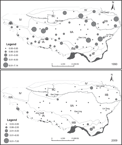
The main explanation for the lower N-NO3 − concentrations in 2008 and 2009 is a sharp decline of the groundwater table; N transformations were associated with the shallower groundwater conditions. While measured N-NO3 − concentrations indicated overall improvements in groundwater quality, several areas of the irrigation district exhibited elevated N-NO2 − concentrations in December 2009 (). In 1990, the average groundwater table depth in the irrigation district was 7 m, in 2009 it was 18 m. This was caused mainly by increased pumping of groundwater for irrigation and industry beginning in 2000.
It should be noted that most groundwater samples were collected from domestic wells, which may have been installed primarily in locations with lower risk of groundwater pollution. This may have caused a bias in sampling towards groundwater with better quality (Mendizabal and Stuyfzand Citation2009).
3.2 Characteristic δ15N values of nitrate
The stable water isotopes (δ2H, δ18O) are ideal tracers for investigating flow processes in the unsaturated zone (Maciejewski et al. Citation2006, Maloszewski et al. Citation2006, Stumpp et al. Citation2007) and can be used to estimate various components of the water balance in soil such as groundwater recharge (e.g. Adomako et al. Citation2010). The isotopic composition of groundwater NO3 − may indicate major contamination sources, since NO3 − from different sources has different characteristic δ15N values (Kendall Citation1998, Kendall and Aravena Citation2000, Kendall et al. Citation2007).
Table 2 presents NO3 − concentrations, isotope values, and the locations of the nine analysed wells. Nitrate sources derived from manure are related to the traditional fertilization of crops in the JID, which before the 1980s was mainly manure-based. The δ15N values ranged from +3.72 to +17.9‰ in 2008 (). Although there is no baseline study on the level of natural NO3 − concentrations in groundwater in this area, data found in the literature indicate that N concentrations above 0.21 mmol L−1 (3 mg L−1) are believed to be a result of anthropogenic sources (Burkart and Kolpin Citation1993, Babiker et al. Citation2004). Based on the literature data (Kendall Citation1998, Mengis et al. Citation2001, Oren et al. Citation2004, Yang et al. 2004, Böhlke et al. Citation2007), as well as the NO3 − and δ15N relationship in the JID, the sources of nitrate can be divided into two types, with +9.0‰ δ15N as a threshold. For samples (from wells D03 and D18, (a)) with δ15N smaller than +9.0‰, the main NO3 − source is chemical fertilizers. Well D03, is located in the town of Yunyang in Jingyang county, and had a NO3 − concentration of 27.9 mg L−1 and δ15N value of +3.72‰. In well D18, located in Yanliang, the values of NO3 − and δ15N were 28.1 mg L−1 and +7.72‰, respectively. The second source of NO3 − is manure (human and animal), which has a value of δ15N larger than +9.0‰. Such samples were found in the seven other wells: D02, D08, D09, D11, D14, D20 and D22.
If denitrification occurred in the groundwater, the nitrate reduction would have to be accompanied by higher δ15N values (averaged more than 12.5‰) since nitrate concentrations are negatively correlated with δ15N values (Kellman and Hillaire-Marcel Citation2003, Menció et al. Citation2011). Because nitrate concentrations have decreased sharply since 1990 and δ15N values were generally high in 2008 (average 12.9‰), we conclude that denitrification occurred in the groundwater.
Also, because manure usually contains large amounts of nitrate and Cl−, waters polluted by manure should also have higher chlorine concentrations (Yang et al. Citation2004). Additionally, Cl− is usually a conservative ion in the unsaturated zone; it rarely sorbs to soils or plants and does not undergo any chemical changes (Broers and Van der Grift Citation2004, Cheng Citation2007). Therefore, Cl− and NO3 − concentrations should show similar trends and the N-NO3 −/Cl− ratio should be relatively constant. If it is not, this would indicate that NO3 − is a result of various transformations. According to our survey, the conventional fertilizer in the JID up to the 1980s was manure (from humans or animals), and after the 1980s, diammonium hydrogen phosphate ((NH4)2HPO4) and monopotassium phosphate KH2PO4 were also used. Thus, except for manure, there have not been other Cl− inputs. Therefore, Cl− can be used as a conservative tracer for agricultural influence on the groundwater of the whole district.
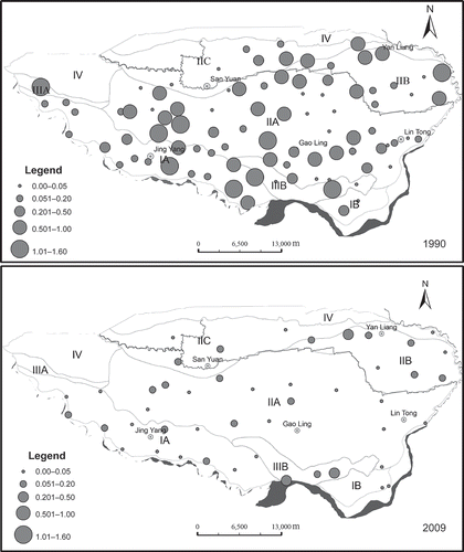
Spatial distributions of the N-NO3 −/Cl− concentration ratio () in 1990 and 2009 show that, except for a small southern part of the irrigation district, Cl− concentrations significantly increased, especially in the Jingyang Yunyang (the northwest irrigation area), the Yujin Lintong (the irrigation district in southeastern areas), and the areas between. However, nitrate concentrations in this region sharply decreased during this period, indicating that strong denitrification occurred. In the northeastern part of the irrigation district (Xiyang of Sanyuan county), both nitrate and chloride concentrations decreased, but nitrate concentrations decreased more than chloride. We hypothesize that this decrease was caused by both denitrification and dilution with irrigation by surface waters. This is consistent with the fact that the poor quality groundwater can no longer be used for irrigation, and only surface water is used for this purpose.
Fig. 4 Ratio of N-NO3 −/Cl− concentrations in the Jinghuiqu Irrigation District in 1990 (top) and 2009 (bottom).
3.3 HYDRUS-1D simulations
3.3.1 Volumetric water contents
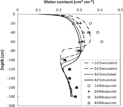
Figure 5 shows water contents measured daily by TDR and compares these values with the results of the HYDRUS-1D simulation. During the experimental period, TDR measurements showed that water contents initially increased and then gradually decreased. Overall, the simulated water contents mirrored measured values at all depths (), except for Day 1 when the largest differences between measured and simulated values were observed. For each day, the relationship between measured and simulated water contents at 10 different depths was evaluated using the root mean squared error (RMSE), which equalled 0.038, 0.022, 0.025 and 0.027 for days 1, 2, 3 and 4 after irrigation, respectively. This indicates a good agreement between measured and simulated values.
Fig. 5 Measured (TDR) and simulated (HYDRUS) volumetric water contents 1, 2, 3 and 4 days after irrigation.
3.3.2 Nitrogen concentrations
The initial N-NO3 − concentrations for numerical simulations were obtained from samples collected before the start of the irrigation experiment (). During the experiment 10.23 g m−2 of fertilizer ((NH4)2HPO4) was applied, leading to a N-NH4 + concentration of 3.16 mmol L−1 in 180 mm of irrigation water.
presents the measured and simulated concentrations of N-NO3 − in the soil solution at six individual depths at two different times. The simulated N-NO3 − concentrations are in good agreement with the observed data, and follow the temporal variations in all depths of the soil profile. The RMSEs were 0.035 and 0.039 mmol L−1 at days 1 and 6 after the irrigation, respectively, and the coefficients of determination (R 2) were 0.90 and 0.89. The greatest differences between measured and simulated concentrations of N-NO3 − in different soil layers of the lysimeter () were found at depths of 0–20 cm at 1 and 6 days after irrigation. The HYDRUS simulations also showed that about 50% of the applied N-NH4 + remained in the top 15 cm of the simulated soil profile 6 days after the irrigation started (). We believe that the main cause for disagreement between our measurements and the model was the sampling. Since after irrigation the concentration values change quickly in the soil profile, especially above 40 cm depth, the measured values of the collected samples often do not fully reflect the dynamic changes occurring during the experiment.
Table 6 Measured and simulated N-NO3 − concentrations 1 and 6 days after irrigation (mmol L−1)
Table 7 Measured (N-NO3 −) and simulated total nitrogen mass in different soil layers at 1 and 6 days after irrigation (mmol m−2)
3.3.3 Predictions of long-term nitrogen leaching
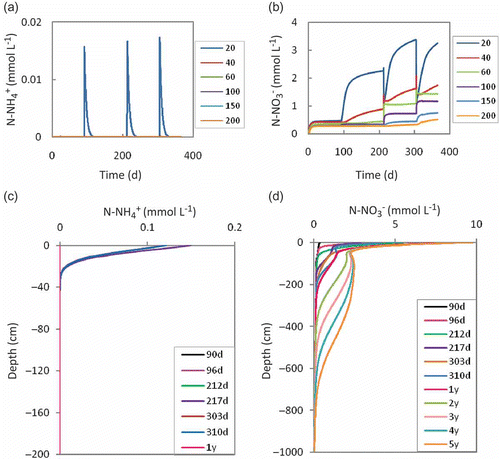
Simulated concentrations of N-NH4 + and N-NO3 − in the soil at different times are presented in (a)–(d). The N-NH4 + concentrations decrease gradually between the soil surface and 20 cm depth, and reach zero below 40 cm depth ((a) and (c)). The N-NH4 + needs about 15 days after irrigation to be completely nitrified. Both N-NH4 + and N-NO3 − concentrations change quickly after irrigation at depths of 20 cm ((a) and (b)). At 20 and 40 cm depth, the N-NO3 − concentrations decreased quickly after irrigation, and then increased gradually to larger values after each new irrigation. Simulations also show that, within two days of flood irrigation, the leaching of N-NO3 − increases significantly. At greater depths, concentrations increase more gradually. The common feature of the N-NO3 − dynamics is that concentrations increased with each irrigation at depths above 60 cm ((d)). This figure also shows that more N-NO3 − is transported down to the groundwater with an increase in the quantity of irrigation water, fertilizer, and longer irrigation times. At the end of the fifth year, the elevated N-NO3 − concentrations had reached a depth of about 7 m, and the N-NO3 − front was descending at a steady rate of about 1.67 m/year, reaching the groundwater in some parts of the irrigation district (the groundwater table depth in 2009 was between 2 and 40 m in the irrigation district).
Fig. 6 Simulated (a) N-NH4 + and (b) N-NO3 − concentrations at different depths (cm), and simulated (c) N-NH4 + and (d) N-NO3 − concentrations at different times (d: day and y: year).
The long-term N transport in the upper part of the soil profile depends on the soil properties of the upper soil layers, which consist mainly of Quaternary fluvial deposits (). To assess the effects of model parameters on the magnitude of N leaching, we either increased or decreased several parameters and repeated the above simulations. reports changes in N concentrations at depths of 4 and 6 m due to 20% change in the saturated hydraulic conductivity, Ks , the dry bulk density, ρ, and the longitudinal dispersivity, λ. shows that the effect of these selected parameters on N leaching is relatively minor.
Table 8 Changes in N concentrations (averaged over a 5-year similation period) at depths of 4 and 6 m due to a ±20% change in the saturated hydraulic conductivity, K s , the dry bulk density, ρ, or the longitudinal dispersivity, λ
Increasing irrigation activities in the JID could speed up the downward movement of N and could lead to increased N loads in the groundwater, even if the manure and fertilizer application at the land surface is reduced to zero. In addition to Cl and N, traditional flood irrigation activities may also cause other agricultural pollutants, such as P and pesticide residues, to reach groundwater resources. A decrease in pH may additionally cause the release of heavy metals from sediments and their downward mobilization. For example, according to our survey in 2009, Cr6+ concentrations increased in groundwater near the industrial town Yanliang (Liu Citation2010).
4 SUMMARY AND CONCLUSIONS
The spatial distribution and temporal variation of groundwater nitrate concentrations, as well as stable isotopes of NO3 − (δ15N-NO3 −), indicate that from 1990 to 2009 both the groundwater table and the concentrations of N-NO3 − decreased significantly. Both the ratio of N-NO3 −/Cl− concentrations and δ15N values in groundwater samples indicate that denitrification controls the nitrogen concentrations in the irrigation district. Collected samples showed that the source of nitrate was mainly manure, which corresponds with historical data indicating that manure was used to fertilize crops before the 1980s.
After comparing simulations by the HYDRUS-1D model against experimental data collected at two lysimeters, the model was used to evaluate future impacts of current irrigation practices on groundwater sources. The results of a five-year modelling of nitrogen fluxes show that when the flood irrigation method is used, nitrate leaching can be significant. Simulations showed that drainage fluxes of N-NO3 − from the soil profile increased after introducing irrigation/fertilization. The N-NO3 − and total nitrogen concentrations increased at all depths after irrigation started. The common feature at all depths is that N-NO3 − concentrations increased with each new irrigation event. Over the span of five years, the irrigation water would have transported N to a depth of about 8 m, reaching the groundwater in many places of the irrigation district. Long-term fertilization and flood irrigation controls the load of N to groundwater.
Existing irrigation practice involving flood irrigation results in N leaching to the groundwater. Therefore, alternative irrigation systems should be tested and adapted in the future in the Jinghuiqu Irrigation District. Such alternative systems should include water-saving micro-irrigation systems, such as surface/subsurface drip or sprinkler irrigation (e.g. Gärdenäs et al. Citation2005). Using less irrigation water will result in a slower downward movement of the N-front and less water leaching towards groundwater, reducing the impairment of groundwater quality. An alternative mitigation option would be to reduce the N-input by lowering the amount of manure/fertilizer applied.
Acknowledgements
This work was supported by the “Program on creation and intellectual importation for hydro-ecology and water security in the arid and semiarid regions” of the Ministry of Education and Foreign Expert Bureau of China (“111” project), and the project “Improving water use efficiency, and the experiment and demonstration of promoting new socialist countryside construction in the irrigation areas” of the Department of Water Resources of Shaanxi Province. Special thanks also go to the Jinghuiqu administration for data sharing.
REFERENCES
- Aber , J.D . 2003 . Is nitrogen deposition altering the nitrogen status of northeastern forests? . Bioscience , 53 : 375 – 389 .
- Adomako , D. 2010 . Estimating groundwater recharge from water isotope (δ2H, δ18O) depth profiles in the Densu River basin, Ghana . Hydrological Sciences Journal , 55 ( 8 ) : 1405 – 1416 .
- Ajdary , K. 2007 . Modelling of nitrogen leaching from experimental onion field under drip irrigation . Agricultural Water Management , 89 : 15 – 28 .
- Allen , R.G. 1998 . Crop evapotranspiration—Guidelines for computing crop water requirements , Rome : Food and Agriculture Organization of UNESCO, FAO Irrigation and Drainage Paper 56 .
- Arumi , L.J. , Oyarzún , R. and Sandoval , M. 2005 . Natural protection against groundwater pollution by nitrates in the Central Valley of Chile . Hydrological Sciences Journal , 50 ( 2 ) : 331 – 340 .
- Babiker , I.S. 2004 . Assessment of groundwater contamination by nitrate leaching from intensive vegetable cultivation using geographical information system . Environment International , 29 : 1009 – 1017 .
- Bellier , O. 1988 . Evolution sédimentaire et tectonique du graben cénozoȉque de la Wei He (province du Shaanxi, Chine du Nord) . Bulletin de la Société géologique de France , IV ( 6 ) : 979 – 994 .
- Boyer , E.W. 2002 . Anthropogenic nitrogen sources and relationships to riverine nitrogen export in the northeastern USA . Biogeochemistry , 57 : 137 – 169 .
- Böhlke , J.K. 2002 . Groundwater recharge and agricultural contamination . Hydrogeology Journal , 10 : 153 – 179 .
- Böhlke , J.K. , O‘Connell , M.E. and Prestegaard , K.L. 2007 . Ground water stratification and delivery of nitrate to an incised stream under varying flow conditions . Journal of Environmental Quality , 36 : 664 – 680 .
- Broers , H.P. and Van der Grift , B. 2004 . Regional monitoring of temporal changes in groundwater quality . Journal of Hydrology , 296 : 192 – 220 .
- Burkart , M.R. and Kolpin , D.W. 1993 . Hydrologic and land use factors associated with herbicides and nitrates in near-surface aquifers . Journal of Environmental Quality , 22 : 646 – 656 .
- Cheng , D.H. 2007 . Hydrogeochemical process and numerical simulation of the total hardness and nitrogen in urban Beijing , 38 – 39 . PhD dissertation. China University of Geosciences . in Chinese with English abstract
- Crevoisier , D. 2008 . Assessment and simulation of water and nitrogen transfer under furrow irrigation . Agricultural Water Management , 95 : 354 – 366 .
- Forkutsa , L. 2009 . Modeling irrigated cotton with shallow groundwater in the Aral Sea Basin of Uzbekistan: II. Soil salinity dynamics . Irrigation Science , 27 : 319 – 330 .
- Galloway , J.N. 2008 . Transformation of the nitrogen cycle: recent trends, questions, and potential solutions . Science , 320 : 889 – 892 .
- Gao , C.F. 2004 . Test of the irrigation technique in the border field . Journal of Northwest Hydroelectric Power , 1 : 140 – 141 . in Chinese with English abstract
- Gärdenäs , A. 2005 . Two-dimensional modeling of nitrate leaching for various fertigation scenarios under micro-irrigation . Agricul1tural Water Management , 94 : 93 – 108 .
- Geake , A.K. and Foster , S.S.D. 1989 . Sequential isotope and solute profiling in the unsaturated zone of British Chalk . Hydrological Sciences Journal , 34 ( 1 ) : 79 – 95 .
- Gonçalves , M.C. 2006 . Multicomponent solute transport in soil lysimeters irrigated with waters of different quality . Water Resources Research , 42 : W08401 doi: 10.1029/2005WR004802.
- Hanson , B.R. , Šimůnek , J. and Hopmans , J.W. 2006 . Evaluation of urea–ammonium–nitrate fertigation with drip irrigation using numerical modeling . Agricultural Water Management , 86 : 102 – 113 .
- Hanson , B.R. , Šimůnek , J. and Hopmans , J.W. 2008 . Leaching with subsurface drip irrigation under saline, shallow ground water conditions . Vadose Zone Journal , 7 : 810 – 818 .
- Hendrilsen , A. and Selmer-Olsen , A.R. 1970 . Automatic methods for determination of nitrate and nitrite in water and soil extracts . The Analyst , 95 : 514 – 518 .
- Jiang , S. 2010 . Modeling water flow and bacterial transport in undisturbed lysimeters under irrigations of dairy shed effluent and water using HYDRUS-1D . Water Research , 44 : 1050 – 1061 .
- Kaown , D. 2009 . Identification of nitrate and sulfate sources in groundwater using dual stable isotope approaches for an agricultural area with different land use (Chuncheon, mid-eastern Korea) . Agriculture, Ecosystems and Environment , 132 : 223 – 231 .
- Kellman , L.M. and Hillaire-Marcel , C. 2003 . Evaluation of nitrogen isotopes as indicators of nitrate contamination sources in an agricultural watershed . Agriculture, Ecosystems and Environment , 95 : 87 – 102 .
- Kendall , C. 1998 . “ Tracing nitrogen sources and cycling in catchment. In ” . In Isotope tracers in catchment hydrology , Edited by: Kendall , C. and McDonnell , J.J. 519 – 576 . Amsterdam : Elsevier .
- Kendall , C. and Aravena , R. 2000 . “ Nitrate isotopes in groundwater system. In ” . In Environmental tracers in subsurface hydrology , Edited by: Cook , P.G. and Hercseg , A.L. 261 – 297 . Boston , MA : Kluwer Academic .
- Kendall , C. , Elliott , E.M. and Wankel , S.D. 2007 . “ Tracing anthropogenic inputs of nitrogen to ecosystems. In ” . In Stable isotopes in ecology and environmental science , Edited by: Michener , R.H. and Lajtha , K. 375 – 449 . Oxford : Blackwell Publishing .
- Kendall , C. and Grim , E. 1990 . Combustion tube method for measurement of nitrogen isotope ratios using calcium oxide for total removal of carbon dioxide and water . Analytical Chemistry , 62 : 526 – 529 .
- Li , M.L. 1998 . Overview of the Jinghuiqu irrigation system of expansion project construction management . Shaanxi Water Resources , 2 : 30 – 31 . in Chinese with English abstract
- Li , Y.J. , Ma , X.Y. and Kang , S.Z. 1999 . Study on the optimal conjunctive use of surface and underground water in Jinghui irrigation region . Transactions of the Chinese Society of Agricultural Engineering , 1 : 130 – 134 . in Chinese with English abstract
- Liu , G.D. and Wu , W.L. 2003 . The dynamics of soil nitrate nitrogen leaching and contamination of the groundwater in high-yield farmland . Chinese Journal of Eco-Agriculture , 11 ( 1 ) : 91 – 93 . in Chinese with English abstract
- Liu , G.X. 2002 . Some sediment problems of the headwork project in Jinghuiqu . Technique of Seepage Control , 2 : 37 – 42 . in Chinese with English abstract
- Liu , X. 2005 . Discussion on optimized arrangement of water resources in Jinghuiqu irrigation area of Shaanxi province . Journal of Water Resources and Architectural Engineering , 3 ( 2 ) : 62 – 64 . in Chinese with English abstract
- Liu , X.H. 2010 . Geochemical evolution of groundwater in Jinghuiqu irrigation areas of Shaanxi province , 46 – 47 . Post Doctoral Research. Institute of Geochemistry, Guiyang, Chinese Academy of Sciences . in Chinese with English abstract
- Liu , X.H. , Li , L. and Wang , Z. 20–22 May 2011 . “ Biogeochemistry characteristics of nitrogen in unsaturated soils of Jinghuiqu irrigation district, China ” . In Proceedings of international symposium on water resource and environmental protection Vol. 2 , 20–22 May , 959 – 962 . Xi'an , China 2011 Beijing, Chine: IEEE
- Liu , Y. 2010 . Dynamic variation characteristics and cause analysis of underground water level in Jinghui irrigation district . Yangtze River , 8 : 100 – 107 . in Chinese with English abstract
- Liu , Y. and Zhu , H.Y. 2011 . Characteristics of interior variation of water environment and regulating capacity of groundwater reservoir in Jinghui canal irrigation district of China . Transactions of the CSAE , 6 : 19 – 23 . in Chinese with English abstract)
- Maciejewski , S. 2006 . Modelling of water flow through typical Bavarian soils (Germany) based on lysimeter experiments: 1. Estimation of hydraulic characteristics of the unsaturated zone . Hydrological Sciences Journal , 51 ( 2 ) : 285 – 297 .
- Maloszewski , P. 2006 . Modelling of water flow through typical Bavarian soils based on lysimeter experiments: 2. Environmental deuterium transport . Hydrological Sciences Journal , 51 ( 2 ) : 298 – 313 .
- Menció , A. 2011 . Nitrate as a tracer of groundwater flow in a fractured multilayered aquifer . Hydrological Sciences Journal , 56 ( 1 ) : 108 – 122 .
- Mendizabal , I. and Stuyfzand , P.J. 2009 . Guidelines for interpreting hydrochemical patterns in data from public supply well fields and their value for natural background groundwater quality determination . Journal of Hydrology , 379 : 151 – 163 .
- Mengis , M. et al., 2001. Limitations of using δ18O for the source identification of nitrate in agricultural soils . Environmental Science and Technology , 35 1840 – 1844 .
- Michel , K. , Herrmann , S. and Ludwig , B. 2010 . Modelling chemical and biological reactions during unsaturated flow in silty arable soils . Geoderma , 156 : 293 – 301 .
- Olson , R.V. and Swallow , C.W. 1984 . Fate of labeled nitrogen fertilizer applied to winter wheat for five years . Soil Science Society of America Journal , 48 : 583 – 586 .
- Oren , O. 2004 . Contamination of groundwater under cultivated fields in an arid environment, central Arava Valley, Israel . Journal of Hydrology , 290 : 312 – 328 .
- Prins , W.H. , Dilz , K. and Neeteson , J.J. 1998 . Current recommendations for nitrogen fertilisation within the E.E.C. in relation to nitrate leaching . London: International Fertiliser Society, Proceedings no. , 276 : 1 – 27 .
- Ramos , T. 2011 . Field evaluation of a multicomponent solute transport model in soils irrigated with saline waters . Journal of Hydrology , 407 : 129 – 144 .
- Rozemeijer , J.C. 2009 . Weather-induced temporal variations in nitrate concentrations in shallow groundwater . Journal of Hydrology , 378 : 119 – 127 .
- Schaap , M.G. , Leij , F.J. and van Genuchten , M.Th. 2001 . Rosetta: a computer program for estimating soil hydraulic parameters with hierarchical pedotransfer functions . Journal of Hydrology , 251 : 163 – 176 .
- Searle , P.L. 1984 . The Berthlot or Indophenol reaction and its use in the analysis chemistry for nitrogen . The Analyst , 109 : 549 – 565 .
- Šimůnek , J. 2009 . Modeling subsurface flow and contaminant transport as influenced by biological processes at various scales using selected HYDRUS modules . Biologia , 64 ( 3 ) : 465 – 469 .
- Šimůnek , J. and Hopmans , J.W. 2009 . Modeling compensated root water and nutrient uptake . Ecological Modelling , 220 : 505 – 521 .
- Šimůnek , J. , van Genuchten , M.Th. and Šejna , M. 2008 . Development and applications of the HYDRUS and STANMOD software packages, and related codes . Vadose Zone Journal , 7 ( 2 ) : 587 – 600 .
- Stumpp , C. 2007 . Quantification of heterogeneity of the unsaturated zone based on environmental deuterium observed in lysimeter experiments . Hydrological Sciences Journal , 52 ( 4 ) : 748 – 762 .
- van Genuchten , M.Th. 1980 . A closed form equation for prediction the hydraulic conductivity of unsaturated soils . Soil Science Society of America Journal , 44 : 892 – 898 .
- Vassiljev , A. , Grimvall , A. and Larsson , M. 2004 . A dual-porosity model for nitrogen leaching from a watershed . Hydrological Sciences Journal , 49 ( 2 ) : 313 – 322 .
- West , L.J. and Truss , S.W. 2006 . Borehole time domain reflectometry in layered sandstone: impact of measurement technique on vadose zone process identification . Journal of Hydrology , 319 : 143 – 162 .
- Wolfe , A.H. and Patz , J.A. 2002 . Reactive nitrogen and human health: acute and longterm implications . Ambio , 31 ( 2 ) : 120 – 125 .
- Yang , Y. 2004 . A new analytical technique of isotope 15N and 18O in NO3 ‐ and the application of N pollution in groundwater of the carst area . Carsologica Sinica , 23 ( 3 ) : 57 – 62 . in Chinese with English abstract
- Zhao , A. and Fei , J.L. 2006 . Modeling of the conjunctive use of surface water and groundwater in irrigation area . Journal of Northwest Hydroelectric Power , 22 ( 5 ) : 23 – 27 . in Chinese with English abstract