Abstract
Water resources management should cover both blue water and green water. For green-water management at the river drainage basin scale, the green-water coefficient (C gw) is adopted, defined as the ratio of annual green water to annual precipitation. Based on data from the Middle Yellow River basin, China, for the period 1950 to 2007, we studied the temporal variation in C gw in response to some influencing factors. A decreasing trend in C gw was found. The influence of changes in land management on C gw, reflected by an increase in the area (A sw) of soil and water conservation measures, is emphasized. Using multiple regression analysis, the contributions of A sw and the 5-year moving averages of annual precipitation and air temperature were estimated as 51, 37 and 12%, respectively. The results may provide useful information for better management of water resources, including green and blue water flows in the Yellow River basin.
Editor Z.W. Kundzewicz; Associate editor D. Gerten
Citation Xu, J.-X., 2013. Effects of climate and land-use change on green-water variations in the Middle Yellow River, China. Hydrological Sciences Journal, 58 (1), 1–12.
Résumé
La gestion des ressources en eau devrait couvrir à la fois les eaux bleues et les eaux vertes. Pour la gestion des eaux vertes à l'échelle du bassin-versant, le coefficient d'eau verte (C gw) a été adopté, défini comme le rapport de l'eau verte annuelle sur les précipitations annuelles. A partir des données du bassin moyen du fleuve Jaune en Chine de 1950 à 2007, nous avons étudié la variation temporelle de C gw en réponse à certains facteurs. Une tendance à la baisse du C gw a été constatée. L'importance des changements de gestion des terres sur le C gw a été mise en évidence par une augmentation de la surface concernée par des mesures de conservation des sols et de l'eau (A sw). En utilisant une régression multiple, les contributions des A sw, des moyennes mobiles sur 5 ans des précipitations annuelles, et de la température de l'air, ont été estimées à respectivement 51, 37 et 12%. Les résultats peuvent fournir des informations utiles pour une meilleure gestion des ressources en eau, incluant les flux d'eaux vertes et bleues, dans le bassin du fleuve Jaune.
1 INTRODUCTION
For a better assessment of agricultural water resources in semi-arid and sub-humid climates, Falkenmark (Citation1995a, Citation1995b) first proposed the green-water concept in 1995. Falkenmark and Rockström (Citation2004) distinguished between two types of water resource, namely the blue-water resource in aquifers, lakes, wetlands and impoundments (e.g. dams), and the green-water resource as moisture in the soil, and between two complementary water flows, namely the liquid blue-water flow through rivers, and aquifers and the green-water vapour flow back to the atmosphere. Precipitation can become either green or blue flow depending on whether it is partitioned into vapour flow or groundwater recharge/surface runoff. The fate of precipitation is determined at the land surface and the unsaturated zone of the soil. The green-water flow has two components: the productive part, or transpiration, involved in biomass production in terrestrial ecosystems, and the non-productive part, or evaporation (Falkenmark and Rockström Citation2006). In other words, green-water comprises water that comes from precipitation and is stored in soil and then consumed by vegetation. Thus, the total amount of green-water resources available in a region in a certain period is equal to the total amount of evapotranspiration in the same region and period. The establishment of the green-water/blue-water theory has enriched the science of water resources and ecohydrology and, in practice, provides a better basis for water resources management, at both the field crop and the river drainage basin scales. Much research on green water has been reported (Falkenmark and Lundqvist Citation1996, Rockström and Gordon Citation2001, Ringersma et al. Citation2003, Falkenmark and Rockström Citation2004, Gerten et al. Citation2005, Jewitt Citation2006, Falkenmark et al. Citation2009), and recent model developments enable a global, spatially explicit, consistent and process-based assessment of green and blue water availability (Vörösmarty et al. Citation2005, Alcamo et al. Citation2007, Liu et al. Citation2007, Rost et al. Citation2008). In 2010, the Journal of Hydrology devoted a special issue to this topic on the methodology of modelling green and blue water at different scales (Hoff Citation2010, Hoff et al. Citation2010, Liu and Yang Citation2010, Sulser et al. Citation2010). Some researchers in China are trying to use this approach (Cheng and Zhao Citation2006, Wang et al. Citation2009, Wu et al. Citation2009). In fact, green water is similar to the traditional concept of evapotranspiration, and the latter is an important subject of hydrology, many studies having been devoted to the temporal and spatial variations of evapotranspiration at global, continental and regional scales and to its formative cause (Peterson et al. Citation1995, Kazama and Teramachi Citation1997, Thomas Citation2000, Stanhill and Cohen Citation2001, Cohen and Stanhill Citation2002, Qiu et al. Citation2003, Hobbins et al. Citation2004, Gordon et al. Citation2005, Jung et al. Citation2010, Gao et al. Citation2011).
The extension of the concept of water resources to include both blue and green water resources is useful in water resources management, especially in the management of soil moisture and evapotranspiration, or the management of green water. It is important in arid or semi-arid areas in general, and in the Yellow River basin of China in particular. For the period from 1919 to 1975, the annual mean natural runoff was 580 × 108 m3, and the basin-averaged annual mean precipitation was 466 mm (1956–1979) (Zhao Citation1996, Xi Citation1999), and thus, the natural runoff coefficient can be estimated as 0.157. This means that 84.3% of the rain water was dissipated as evapotranspiration. This high percentage can be attributed to the semi-arid climate and thick loess mantle in the river basin (Xu Citation2005). The fact that green water in the Yellow River basin involves 84.3% of the water resources is as of yet not explicitly considered in water resources management. Obviously, considering green water as a part of water resources may help to establish more effective management of water resources in this region.
Many studies have shown that in the past 50 years the runoff of the Yellow River has a decreasing trend, which has been caused by climate change and human activity (e.g. Fu et al. Citation2004, Yang et al. Citation2004, Xu Citation2005, Xu and Ma Citation2009, Gao et al. Citation2010). In the present study, the green-water concept is applied to research at the scale of the Yellow River basin, including: (a) adopting a simple index of green-water coefficient (C gw), defined as the ratio of annual green-water amount to precipitation amount; (b) studying the variations in C gw in relation to some influencing factors; and (c) providing some useful information for water resources management, especially for green-water management at the river drainage basin scale.
2 OUTLINE OF THE STUDY AREA
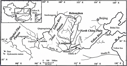
The Hekouzhen-Longmen drainage area in the Middle Yellow River () was selected as the study area, and is the main part of the famous Loess Plateau, with an area of 112 000 km2. It has a temperate semi-arid climate influenced by monsoons, with annual precipitation ranging from 350 to 550 mm, which is often concentrated as several rainstorms. The dominant natural vegetation types are temperate steppe and the transitional vegetation from steppe to warm temperate forest (Yang and Yuan Citation1991). This area is mantled by loess several tens to 200 m in thickness, which is deeply dissected. The loess is highly permeable, but only a small portion of the infiltrated rain water can reach the level of groundwater; the remainder is lost as transpiration in the dry seasons. Thus, the runoff coefficient is low. According to data from the period 1950–1999, the annual mean runoff measured at Hekouzhen and Longmen stations was 229.1 × 10⁸ m3 and 283.3 × 10⁸ m3, respectively, the area-averaged annual mean precipitation was 436.3 mm, and the runoff generated in the drainage area between these two stations was 54.2 × 10⁸ m3. Thus, the runoff coefficient can be calculated as 0.111.
Fig. 1 Map of the Yellow River basin. The dotted line shows the Hekouzhen-Longmen drainage area.
Like many other large river basins in the world, the Yellow River basin has undergone marked land-use and land-cover changes in the past 50 years due to increasing human activity. The land-use and land-cover changes include deforestation and reforestation, cultivation of hillslope land and “returning the cultivated land to wood and grass land”, urbanization and road building. As the study area is the major sediment source area of the Yellow River with the highest intensity of erosion and sediment yield, the most important change is the implementation of large-scale soil and water conservation measures, which change land-use and land-cover significantly.
It should be pointed out that the study area is not a complete catchment, but a drainage area between two hydrometric stations. Two points of consideration led us to select this area. First, one of the main objectives of the present study is to elucidate the influence of soil and water conservation measures on green water, and the Hekouzhen-Longmen drainage area is large-scale and subject to the most intensive water and soil conservation measures in China. Up to 2006, the total area of soil conservation measures was 37 060 km2 (Yellow River Water Conservancy Commission Citation2007), accounting for 33.1% of the total drainage area. Second, to estimate natural river flow, the amount of net diversion of water from the river should be added back to the measured river flow. Based on data from the Yellow River Water Resources Bulletin (Yellow River Water Conservancy Commission Citation2008), it was calculated that in the Hekouzhen-Longmen drainage area the annual mean net water diversion is 3.76 × 10⁸ m3/year, accounting for 14.4% of the natural river flow. Based on annual data from 1950 to 2007, it is calculated that the correlation coefficient of annual net water diversion with time is 0.4827, indicating a significant (p < 0.01) increasing trend. For the whole Yellow River basin, the annual mean net water diversion is 242.88 × 10⁸ m3/year, accounting for 44.4% of the natural river flow. In general, the error of water diversion estimation is larger than that of water discharge measurement at hydrometric stations, and the greater the water diversion is, the lower the accuracy of the calculation of natural river flow. Hence, the Hekouzhen-Longmen drainage area, rather than the whole Yellow River basin, is selected as the study area.
3 METHOD AND DATA SOURCES
As pointed out earlier, green water includes two components, productive (vegetation transpiration) and non-productive (land surface evaporation). Of the two components, the former is more significant in water resources management. Although the partitioning was done for cropland in China (Liu Citation2009), the data are limited and not sufficient to study the two components separately at the drainage basin scale for the Yellow River. Hence, the present study discusses the green water as a whole. According to the water balance equation:
In general, most of the ΔS surface is caused by the change in water storage of reservoirs and, when calculating Q wn, the change in water storage of reservoirs is taken into account. Since at a time scale of one year or longer, ΔS soil and ΔS ground and the change in water storage in the river channel are negligibly small, they are omitted due to lack of data. Hence, P = ET + Q wn = Q green + Q blue because ET and Q wn are the amounts of green water (Q green) and blue water (Q blue), respectively.
To study the formative mechanism of green water, we consider a simple index of green-water transformation:
It should be pointed out that the green-water coefficient defined herein is the equivalent of the evapotranspiration coefficient (equal to 1.00 minus the natural runoff coefficient). Nevertheless, the use of C gw emphasizes the rate of transformation from precipitation to green water, and is convenient for green-water assessment and management, which will improve water resources management in the Yellow River basin.
The annual measured runoff (Q wm,H-L) generated from the drainage area between Hekouzhen and Longmen stations is calculated as the annual runoff at Longmen station (Q wm, L) minus that at Hekouzhen station (Q wm,H) based on data from 1950 to 2007. The annual natural runoff (Q wn,H-L) generated from the drainage area between Hekouzhen and Longmen stations is calculated as the measured runoff plus the net water diversion (Q w,div,H-L) from this area:
Note that, as pointed out earlier, the change or increase in water storage (ΔS
w) of reservoirs is considered when calculating Q
w,div,H-L. Researchers of the Commission of Yellow River Water Conservancy did some investigation to calculate the amount of water diversion for irrigation, industrial and domestic water uses; they also estimated the amount of water returning to the river after use, and the annual change of water storage by reservoirs in the study area. Thus, Q
w,div,H-L can be obtained. These data are provided by the Commission of Yellow River Water Conservancy. Using Equationequation (3)(3), Q
wn,H-L data and annual precipitation over the Hekouzhen-Longmen drainage area, annual C
gw for the study area was calculated.
To study how the C gw is influenced by climate change, the following indices are introduced: annual precipitation, P m, annual air temperature, T m, and the intensity of summer monsoon, SMI. Many indices have been proposed to describe quantitatively the intensity of the monsoon, based on the consideration of thermal contrast between continent and ocean, or the resulting difference of air pressure between continent and ocean (Barnett et al. Citation1999, Zhou et al. Citation2009). To describe the Eastern Asian monsoon, a few indices have been proposed (Guo Citation1990, Shi et al. Citation1996, Xu et al. Citation1997, Zhao et al. Citation2008). The summer monsoon index (SMI) (Guo Citation1990) is defined in terms of the gradient of air pressure between the Asian Continent and Pacific Ocean, and directly based on the formative mechanism of the Eastern Asian monsoon. Thus, this index is adopted in the present study. The SMI is defined as the difference in the monthly average air pressure in the summer season (June, July and August) at sea level between the continent and the ocean in the range of 10°–50°N (Guo Citation1983, Citation1987, Citation1990). For the calculation procedures, see Guo (Citation1987, Citation1990). Using this index, Guo studied the trend of inter-annual variation in SMI and its influence on precipitation (Guo Citation1987, Citation1990). Many other researchers (Ding et al. Citation2008, Citation2009, Zhao et al. 2008) found that there is a close relationship between summer monsoon indices and precipitation in eastern Asia and in China.
Annual precipitation data from 158 rain stations (with a density of 709 km2/station) are provided by the Yellow River Water Conservancy Commission, and the area-weighted average is calculated using the Thiessen polygon method. The data of annual temperature from 30 county meteorological stations (with a density of 3700 km2/station) are provided by the Chinese National Bureau of Meteorology, and the arithmetic mean temperature is used because the number of stations is small. When calculating the mean temperature, topography is not taken into consideration. All the data were collected and error-checked following the national standards for meteorological and hydrological measurements in China. Since the effect of water diversion was considered when calculating C gw, the human factor considered in this study comprises four types of soil and water conservation measures: land terracing, tree planting, grass planting and check-dam building. The effect of the first three measures is indexed by their areas, and that of check-dam building by the area of land created by the sediment trapped above the check dam (Wang and Fan Citation2002). The SMI data calculated by Guo are used in this study for the period from 1950 to 2000. Post-2000 data were not available, so the monsoon-related analysis is for the period from 1951 to 2000.
4 RESULTS AND DISCUSSION
4.1 Temporal variations in green-water coefficient and influencing factors
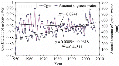
shows the temporal variations in annual amount and coefficient of green water in the Hekouzhen-Longmen drainage area. The former shows a slight decrease, but it is not significant. The latter shows an increasing trend, which is significant at the confidence level of p < 0.01. Note that the 1950 data point is much lower than the trend line and that the points of 2006 and 2007 near the end are also lower. Thus, they look like “outliers”. If the 1950, 2006 and 2007 data are excluded, the determination coefficient (R 2) of C gw with time becomes 0.4485. If only the point of 1950 is excluded, the determination coefficient becomes 0.4264. In both cases the determination coefficients are lower than 0.4511, which is for all the data points. Since the difference is small and, in the two cases, the level of significance p is still less than 0.01, we suggest that the decreasing trend in C gw is real and not an artefact of these “outliers”.
Fig. 2 Temporal variation in annual green-water coefficient (C gw) and the amount of green water in the Hekouzhen-Longmen drainage area.
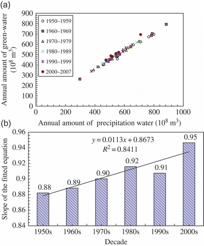
The relationship between annual green-water amount (Q green) and annual precipitation (P m) is plotted in (a), where the points from different periods are distinguished by different symbols. The period 1950–1969 is usually considered as the “base-line period” in the study area when large-scale soil and water conservation measures were not implemented, and the period afterwards as the “period with measures” (Xu and Niu Citation2000, Wang and Fan Citation2002). The “period with measures” may be further divided into four sub-periods. The data for different periods can be fitted by linear regression equations with the intercept set as 0: Q green = aP m. The equations for the five periods are all significant at p < 0.001, and the R 2 values are all higher than 0.98. The slope (a) equals the average C gw for each period. The slope for the four sub-periods increased gradually ((b)), and for the period 1998–2007, it increased to 0.95. This indicates that C gw increased relative to P; in other words, the increased C gw is caused by some factors other than P.
Fig. 3 Relationship between green water and annual precipitation: (a) annual amount of green water as a function of annual precipitation for different periods; and (b) slope of the equation fitted for five time periods.
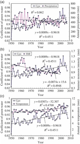
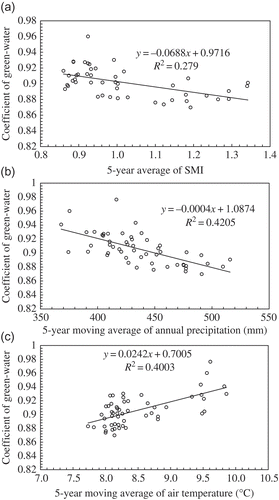
A comparison of the temporal variation in C gw with those in climate indices, including annual precipitation, air temperature and SMI, is shown in The trend in C gw is the inverse of those in precipitation and SMI, but similar to that in air temperature. Thus, the weakened SMI and the resulting decrease in precipitation may lead to an increased C gw, and the increased air temperature may be conducive to the increased C gw.
Fig. 4 Comparison of temporal variation in green-water coefficient (C gw) with that in climate indices: (a) precipitation; (b) summer monsoon intensity, SMI; and (c) air temperature.
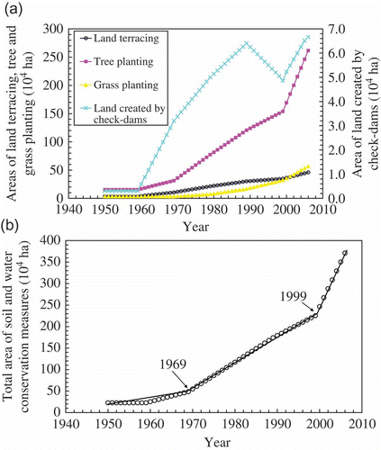
In the years 1959, 1969, 1979, 1989, 1999 and 2006, the total area (A sw) of soil and water conservation measures was 227 000, 486 000, 1 109 000, 1 741 000, 2 255 000 and 3 710 000 ha, respectively—a significant increasing trend. The fact that both C gw and A sw increase with time means an increase in A swc may lead to increased C gw.
4.2 Relationship between green-water coefficient and influencing factors
4.2.1 Climate variables
Although the overall trend in C gw is close to the overall trends in SMI, P m and T m, there are marked secondary fluctuations at 3–5 year scales on the curves of climate variables (see ). This leads to low R 2 values for C gw regressed with SMI, P m and T m, of 0.1744, 0.0156 and 0.103, respectively. However, when these secondary fluctuations are offset using a 5-year moving average, the correlation becomes much closer (see (a), (b) and (c)). The t-test indicates that the three correlation coefficients are all significant at p < 0.01. The 5-year moving averages of SMI, P m and T m are referred to as SMI5m, P m,5m and T m,5m. The C gw is negatively correlated with SMI5m and P m,5m, and positively correlated with T m,5m. The R 2 values of C gw with SMI5m, P m,5m and T m,5m are 0.279, 0.4205 and 0.4004, respectively (see ), indicating that the percentages of variation in C gw that can be explained by SMI5m, P 5m and T 5m are 27.9%, 42.1 and 40.0%. The fact that C gw is much better correlated with SMI5m, P 5m and T 5m than with SMI, P m and T m implies that the variation in C gw is controlled by climate variability at longer time scales, and low-frequency variations have much less influence. It is particularly true for precipitation because after the 5-year moving average treatment, the R 2 increases sharply from 0.0156 to 0.4205. Probably, at longer time scales, the variation in climate variables influences land surface properties such as vegetation and soil conditions and, thereby, further change in the C gw. However, for the time-being data are not available to study this long-term effect.
Fig. 5 Relationships between green-water coefficient (C gw) and 5-year averages of climate indices: (a) summer monsoon intensity, SMI; (b) precipitation; and (c) air temperature.
4.2.2 Land-use and land-cover changes in the river basin
The practice of soil and water conservation measures changes land-use and land-cover and therefore the conditions for runoff generation. According to field observations in the study area, when daily rainfall is less than 50 mm and relatively uniformly distributed, all the rainfall can infiltrate into the soil and no river flow is generated from the terrace land (Xu and Niu Citation2000). Some plot experiments showed that land terracing can reduce surface runoff by 70–90%, compared with the sloping cultivated land (Xu and Niu Citation2000).
At several experiment stations for soil and water conservation in the Loess Plateau region, comparative experiments were conducted on reforested and bare slopeland plots with comparable size, slope steepness, slope length and other conditions such as precipitation and soil type. The results show that reforestation can reduce surface runoff by 30.81–75.1%, and grass planting can reduce surface runoff by 17.2–58.9% (Xu and Niu Citation2000, Tables 4.20 and 4.22, pp. 144–143). As gullies on the Loess Plateau are usually deeply cut, many being 30–50 m deep, the level of groundwater is very low (Xu Citation2005). Thus, it is likely that only a small proportion of infiltrating rainwater could reach the groundwater surface, and the remainder is dissipated to the atmosphere through evapotranspiration during dry seasons (Xu Citation2005). Check-dams trap sediment and intercept runoff during rainstorms, and, afterwards, the stored water is dissipated gradually by evaporation. Furthermore, after soil and water conservation, the enhanced growth of vegetation, i.e. crops on terraced land and on the land created above check-dams, and trees and grass planted by man, may consume more water than before, especially on the high-yield terraced land and woodland with high canopy density (Wang and Fan Citation2002). Therefore, evapotranspiration significantly increases.
To assess the effect of different water and soil conservation measures on hill-slope runoff processes, many researchers conducted plot experiments in various places on the Loess Plateau (Zhang Citation1999, Zhao and Zhang Citation2005, Yu et al. Citation2010). For instance, Zhao and Zhang (Citation2005) took four land-use types for plot experiments. The projected area of each plot was 10 m2 (5 m long and 2 m wide), under artificial rainfall. The sloping cropland, woodland and shrubland had the same slope steepness (27°), and the terraced cropland had a slope of 3°. Their results showed significant differences. Setting the values for sloping cropland as 100%, the surface runoff for terraced cropland, woodland and shrubland was 59, 12 and 13%, the infiltration was 191, 266 and 299% and the ratio of infiltration to rainfall was 192, 297 and 297%, respectively (Zhao and Zhang Citation2005). This means that, if the sloping cropland is changed to terraced cropland, woodland or shrubland, surface runoff will greatly decrease, and infiltration and the ratio of infiltration to rainfall will greatly increase. Because of the thick loess mantle, most of the infiltrating rain water is dissipated as evapotranspiration during dry seasons and cannot reach the groundwater to become blue water. Hence, most of the infiltrating rain water can be regarded as green water. Therefore, the implementation of large-scale water and soil conservation measures may considerably increase the green-water coefficient. The results from the studies at slope or field scale in the Yellow River basin may explain the findings of the present study and, vice versa, the findings of the present study at a larger spatial scale can support these previous results.
The temporal variations in the areas of four types of soil and water conservation measures are shown in (a), and the temporal variation in the total area of four measures is shown in (b). The areas of all four measures show increasing trend, except from 1989 to 1999, when the area of land created by check-dams decreased. The variation of total area of the four measures shows two turning points, at 1969 and 1999, after which the rate of increase becomes larger, meaning that the soil and water conservation was enhanced after 1969, and further enhanced after 1999.
Fig. 6 Variation in time of the area of soil and water conservation measures: (a) four individual measures; and (b) total area of measures.
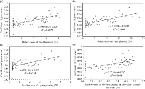
All types of soil and conservation measures result in stronger evapotranspiration at the drainage basin scale and, therefore, C gw increase. shows the relationships between C gw and soil and water conservation measures including land terracing, planting of trees and of grass, and the land created by check-dams. To help interpret the significance of the changes, the relative area of each measure is used, expressed as the percentage of the area of the measure relative to the drainage area between Hekouzhen and Longmen. It is seen that C gw is positively correlated with the above four indices, and the correlation coefficients are all significant at a confidence level of p < 0.01. Thus, shows that land terracing, tree and grass planting and check-dam building result in an increased C gw in the study area. The determination coefficients (R 2) are 0.4877, 0.4904, 0.4264 and 0.3948, respectively; i.e. 48.8, 49.0, 42.6 and 39.5% of the variation in C gw can be explained by the variations in the above four measures, respectively.
Fig. 7 Relationships between green-water coefficient (C gw) and the relative area of different soil and water conservation measures: (a) land terracing; (b) planting of trees; (c) planting of grass; and (d) the land created by the checkdam-trapped sediment.
The variation in C gw is influenced by many factors, including climate and human activity. These variables act in different directions, and the resultant effect of one variable may be partly offset by that of another. Thus, the cause-and-effect relationships are complicated, and more research is needed. In the past 30 years, urbanization and road building have occurred in the study area, and these may change the C gw. Urbanization and road building has increased the impermeable area in the drainage basin, whereby surface runoff increases and infiltration decreases. Hence, green water will decrease and also the C gw. The direction in which the urbanization and road building influence C gw is the opposite of that of other types of human activities, such as soil and water conservation and vegetation reconstruction, which increase C gw. As C gw showed an increasing trend, the effect of urbanization and road building is secondary when compared to that of soil and water conservation and vegetation reconstruction.
4.3 Assessment of the relative contribution of factors influencing C gw
To assess the relative contribution of the influencing variables on the temporal variation in C gw, multiple regression analysis was performed. As the change in precipitation may be caused by the changed monsoon, it is not necessary to include both P m and SMI, so the latter is not considered. Hence, the influencing variables are annual precipitation (P m in mm), annual air temperature (T m in °C) and the total area (A sw in 104 ha) of soil and water conservation measures including land terracing, tree planting, grass planting and check-dam building. The correlation coefficients of C gw with P m, T m and A sw were calculated as –0.14, 0.44 and 0.71, respectively. The correlation coefficient of C gw with P m is too low to include in a multiple regression equation. At longer time scales, some effects on C gw driven by climate variables may occur. These effects may be reflected by 5-year averages of annual precipitation (P m,5m) and air temperature (T m,5m). The correlation coefficients of C gw with P m,5m, T m,5m and A sw were calculated as –0.65, 0.66 and 0.73, respectively. Considering this, it is more reasonable to take P m,5m, T m,5m and A sw as influencing variables. As pointed out earlier, the variation in C gw is controlled by variations in P and T at longer time scales rather than by the lower-frequency variations. For the planning of green-water management, consideration of climate variability at longer time scales is important and useful. For this purpose, a linear multiple regression equation of C gw with P m,5m, T m,5m and A sw has been established as follows:
Since the order of magnitude of the variables differs, the regression coefficients of the equation cannot be used to rank the relative contributions of the variables to variation in C gw. Thus, a standardization treatment was applied to the data, transforming the values of all the variables to the range 0 to 1, using the formula: X′ = (X – X min)/(X max – X min), where X, X′ are the values from a variable before and after standardization, and X min, X max are the minimum and maximum values of the variable. Then, the equation was re-established as follows, with the constant set as 0:
5 CONCLUSIONS
To study temporal variation in green water at the drainage basin scale, an index, the coefficient of green water, was introduced, and is defined as the ratio of actual evapotranspiration to precipitation. Based on data from the period 1950–2007, a decreasing trend in C gw in the drainage area between Hekouzhen and Longmen in the Middle Yellow River basin has been found, while a decrease in summer monsoon intensity and precipitation and an increase in air temperature were observed. The influence of land-use change reflected by an increase in the area of soil and water conservation measures is emphasized. The determination coefficients (R 2) of C gw with the area of land terracing, tree planting, grass planting and the land created by check-dams indicate that 49, 49, 43 and 39% of the variation in C gw can be explained by these four types of measures, respectively.
A linear multiple regression equation of C gw with total area (A sw) of soil and water conservation measures and 5-year moving averages of annual precipitation (P m,5m) and air temperature (T m,5m) was established, based on which the contributions of A sw, P m,5m and T m,5m were estimated as 51, 37 and 12%, respectively.
Although green water is similar or equivalent to evapotranspiration, and the green-water coefficient introduced herein is similar or equivalent to the evapotranspiration coefficient, C gw has more meaning than the evapotranspiration coefficient. Introduction of C gw may help better understanding of the effect of soil and water conservation measures, which are very important in the drainage basin management of the Yellow River. Some studies (e.g. Wang and Fan Citation2002) dealing with the decreasing trend of river flow in the Yellow River regarded the decrease as a reduction of water resources that therefore should be avoided to some degree. However, the reduction of river flow by soil and water conservation measures and enhanced vegetation and crop growth does not necessarily mean a “loss” of water resources, because the green-water, or the water consumption by water conservation measures and enhanced vegetation and crops, is reasonable utilization of water resources and the reduction of river flow is compensated by the utilization of green-water resources. Thus, the introduction of C gw may help in the better assessment and planning of water resources utilization in the Yellow River basin and other similar river basins.
In the present paper, the analysis focuses on annual averages or sums of precipitation, temperature, water discharge and ET for the 112 000 km2 Hekouzhen-Longmen drainage area in the Middle Yellow River basin. No doubt the intra-annual dynamics and spatial differences within the area are important for the assessment and management of green-water resources in this area. However, for the time-being, because the monthly data for water diversion are not available, the monthly “natural” runoff cannot be calculated, and so analysis on the intra-annual dynamics of evapotranspiration cannot be performed. For the tributaries in the study area, we have the same difficulty. We will do more work along this line in the future when data are available.
Acknowledgements
The financial support from Natural Science Foundation of China (41071016), the National Major Basic Research Programme of China (grant no. 2010CB428404) and the Chinese Academy of Sciences is gratefully acknowledged. All hydrometrical data used in this study are provided by the Yellow River Water Conservancy Commission. The data of SMI was provided by Professor Qiyuan Guo. I am grateful to two anonymous reviewers and Dr Dieter Gerten, whose comments and suggestions were valuable for improvement of the manuscript.
REFERENCES
- Alcamo , J. , Floerke , M. and Maerker , M. 2007 . Future long-term changes in global water resources driven by socio-economic and climatic changes . Hydrological Sciences Journal , 52 ( 2 ) : 247 – 275 .
- Barnett , T.P. 1999 . Interdecadal interactions between the tropics and midlatitudes in the Pacific basin . Geophysical Research Letters , 26 : 615 – 618 .
- Cheng , G.D. and Zhao , W.Z. 2006 . Green-water and its research progresses . Advances in Earth Sciences , 21 ( 3 ) : 221 – 227 . (in Chinese)
- Cohen , S. and Stanhill , G. 2002 . Evaporative climate changes at Bet-Dagan, Israel, 1964–1998 . Agricultural and Forest Meteorology , 111 ( 2 ) : 83 – 91 .
- Ding , Y.H. , Sun , Y. and Wang , Z.Y. 2008 . Inter-decadal variation of summer precipitation in East China and its association with decreasing Asian summer monsoon: part I—observed evidence . International Journal of Climatology , 28 : 1139 – 1161 .
- Ding , Y.H. 2009 . Inter-decadal variation of the summer precipitation in East China and its association with decreasing Asian summer monsoon: part II—possible causes . International Journal of Climatology , 29 : 1926 – 1944 .
- Falkenmark , M. Coping with water scarcity under rapid population growth . Conference of SADC Ministry . November 23–24 1995 . . In:, Pretoria.
- Falkenmark , M. 1995b . Land water linkages: a synopsis , 15 – 16 . Rome : Food and Agriculture Organization, FAO Land and Water Bulletin no. 1 .
- Falkenmark , M. and Lundqvist , J. 1996 . “ Comprehensive water resources assessment ” . In UN comprehensive assessment of the freshwater resources of the world , Stockholm : Stockholm Environment Institute . . In:
- Falkenmark , M. and Rockström , J. 2004 . Balancing water for humans and nature: a new approach to ecohydrology , London : Earthscan .
- Falkenmark , M. and Rockström , J. 2006 . The new blue and green water paradigm: breaking new ground for water resources planning and management . Water Resource Planning and Management, ASCE , 132 ( 3 ) : 129 – 132 .
- Falkenmark , M. , Rockström , J. and Karlberg , L. 2009 . Present and future water requirements for feeding humanity . Food Security , 1 : 59 – 69 .
- Fu , G.B. 2004 . Hydro-climatic trends of the Yellow River basin for the last 50 years . Climatic Change , 65 ( 1 ) : 149 – 178 .
- Gao , G . 2011 . “ Spatial and temporal characteristics of actual evapotranspiration over Haihe River basin in China estimated by the complementary relationship and the Thornthwaite water balance model ” . In Stochastic Environmental Research & Risk Assessment doi:10.1007/s00477-011-0525-1
- Gao , P. 2010 . Trend and change-point analyses of streamflow and sediment discharge in the Yellow River during 1950–2005 . Hydrological Sciences Journal , 55 ( 2 ) : 275 – 285 .
- Gerten , D. 2005 . Contemporary “green” water flows: simulations with a dynamic global vegetation and water balance model . Physics and Chemistry of the Earth , 30 : 334 – 338 .
- Gordon , L.J. 2005 . Human modification of global water vapor flows from the land surface . Proceedings of National Academy of Science , 102 ( 21 ) : 7612 – 7617 .
- Guo , Q.Y. 1983 . The summer monsoom intensity index in East Asia and its variation . Acta Geographica Sinica , 38 ( 3 ) : 207 – 217 . (in Chinese)
- Guo , Q.Y. 1987 . “ The East Asia monsoon and the southern oscillation, 1871–1980. In: Ye Duzheng, et al ” . In The climate of China and global climate , 249 – 255 . Beijing : China Ocean Press, Springer Verlag .
- Guo , Q.Y. 1990 . “ A study of climate related with Eastern Monsoon ” . In Progress in geography , Edited by: D.K. Zuo , ed . 63 – 70 . Beijing : Science Press . In(in Chinese)
- Hobbins , M.T. , Ramırez , J.A. and Brown , T. C. 2004 . Trends in pan evaporation and actual evapotranspiration across the conterminous U.S.: paradoxical or complementary? . Geophysical Research Letters , 31 : L13503 doi:10.1029/2004GL019846
- Hoff , H. 2010 . The global water challenge—modeling green and blue water . Journal of Hydrology , 384 ( 3–4 ) : 175 – 176 .
- Hoff , H. 2010 . Greening the global water system . Journal of Hydrology , 384 ( 3–4 ) : 177 – 186 .
- Jewitt , G. 2006 . Integrating blue and green water flows for water resources management and planning . Physics and Chemistry of the Earth , 31 : 753 – 762 .
- Jung , M. 2010 . Recent decline in the global land evapotranspiration trend due to limited moisture supply . Nature , 467 : 951 – 954 .
- Kazama , S. and Teramachi , S. 1997 . Estimation of the evapotranspiration distribution in Japan using NDVI . Computing in Civil and Building Engineering , 3 : 1741 – 1746 .
- Liu , J. 2007 . GEPIC—modelling wheatyield and crop water productivity with high resolution on a global scale . Agricultural Systems , 94 ( 2 ) : 478 – 493 .
- Liu , J.G. 2009 . Consumptive water use in cropland and its partitioning: a high-resolution assessment . Science in China Series E: Technological Sciences , 52 ( 11 ) : 3309 – 3314 .
- Liu , J.G. and Yang , H. 2010 . Spatially explicit assessment of global consumptive water uses in cropland: green and blue water . Journal of Hydrology , 384 ( 3–4 ) : 187 – 197 .
- Peterson , T.C. , Golubev , V.S. and Groisman , P.Y. 1995 . Evaporation losing its strength . Nature , 377 : 687 – 688 .
- Qiu , X.F. , Liu , C.M. and Zeng , Y. 2003 . Changes of pan evaporation in the recent 40 years over the Yellow River basin . Journal of Natural Resources , 18 ( 4 ) : 437 – 442 . (in Chinese)
- Ringersma , J. , Batjes , N. and Dent , D. 2003 . Green water: definitions and data for assessment , Wageningen , , The Netherlands : ISRIC Report .
- Rockström , J. and Gordon , L. 2001 . Assessment of green water flows to sustain major biomes of the world: implications for future ecohydrological landscape management . Physics and Chemistry of the Earth (B) , 26 ( 11–12 ) : 843 – 851 .
- Rost , S. 2008 . Agricultural green and blue water consumption and its influence on the global water system . Water Resources Research , 44 : W09405 doi:10.1029/2007WR006331
- Shi , N. , Lu , J.J. and Zhu , Q.G. 1996 . Intensity index of winter and summer Eastern Asian monsoon and the relative climate change . Journal of Nanjing Institute of Meteorology , 19 ( 2 ) : 168 – 177 . (in Chinese)
- Stanhill , G. and Cohen , S. 2001 . Global dimming: a review of the evidence for a widespread and significant reduction in global radiation with discussion of its probable causes and possible agricultural consequences . Agricultural and Forest Meteorology , 107 : 255 – 278 .
- Sulser , T.B. 2010 . Green and blue water accounting in the Ganges and Nile basins: implications for food and agricultural policy . Journal of Hydrology , 384 ( 3–4 ) : 276 – 291 .
- Thomas , A. 2000 . Spatial and temporal characteristics of potential evapotranspiration trends over China . International Journal of Climatology , 20 : 381 – 396 .
- Vörösmarty , C. 2005 . Geospatial indicators of emerging water stress: an application to Africa . Ambio , 34 ( 3 ) : 230 – 236 .
- Wang , G. and Fan , Z. , eds. 2002 . A study of water and sediment changes in the Yellow River , Vol. 1 and 2 , Zhengzhou : Publishing House of Yellow River Water Conservancy . edsVolumes(in Chinese)
- Wang , Y.J. 2009 . The analysis on the pattern of eco-water use of vegetation and the availability of green water in Sanmenxia area of Yellow River . Geographical Research , 28 ( 11 ) : 74 – 84 . (in Chinese)
- Wu , H.T. 2009 . Assessment of green water from multi-angle view at catchment scale . Resources Science , 31 ( 3 ) : 420 – 428 . (in Chinese)
- Xi , J.Z. 1999 . Water resources of the Yellow River , Zhengzhou : Publishing House of Yellow River Water Conservancy . (in Chinese)
- Xu , J.H. and Niu , Y.G. 2000 . Effect of hydraulic engineering works on river flow and sediment load in the Middle Yellow River basin , Zhengzhou : Publishing House of Yellow River Water Conservancy . (in Chinese)
- Xu , J.J. , Zhu , Q.G. and Shi , N. 1997 . An analysis of abnormal spectrum in the variation of summer eastern Asian monsoon in the past 100 years . Journal of Meteorology , 55 ( 5 ) : 620 – 626 . (in Chinese)
- Xu , J.X. 2005 . Temporal variation of river flow renewability in the Middle Yellow River and the influencing factors . Hydrological Processes , 19 ( 9 ) : 1871 – 1882 .
- Xu , J.X. and Ma , Y.X. 2009 . Response of the hydrological regime of the Yellow River to the changing monsoon intensity and human activity . Hydrological Sciences Journal , 54 ( 1 ) : 90 – 100 .
- Yang , D. 2004 . Analysis of water resources variability in the Yellow River of China during the last half century using historical data . Water Resources Research , 40 : W06502 doi:10.1029/2003WR002763
- Yang , Q.Y. and Yuan , B.Y. , eds. 1991 . Natural environment and its changes in the Loess Plateau Region , Beijing : Science Press . (in Chinese)
- Yellow River Water Conservancy Commission . 2007 . Yearbook of the Yellow River (2006) , Zhengzhou : Publishing House of Yellow River Water Conservancy . (in Chinese)
- Yellow River Water Conservancy Commission . 2008 . Yellow River Water Resources Bulletin (2007) (in Chinese)
- Yu , G.Q. 2010 . Effects of vegetation types on hillslope runoff erosion and sediment yield . Advances in Water Science , 21 ( 5 ) : 593 – 599 . (in Chinese)
- Zhang , Z.G. 1999 . Study of effects of runoff and sediment reduction by forestation on leveling steps in rolling gullied loess region in West Shanxi province . Soil and Water Conservation in China , 1 : 24 – 25 . (in Chinese)
- Zhao , H.R. and Zhang , W.H. 2005 . Simulated rain-infiltration on plots in a hilly and gullied loess area in West Shanxi province . Modern Agriculture , 3 : 41 – 42 . (in Chinese)
- Zhao , P. 2008 . Summer Asian Pacific oscillation and its relationship with atmospheric circulation and monsoon rainfall . Acta Meteorologica Sinica , 66 ( 5 ) : 716 – 729 . (in Chinese)
- Zhao , W.L. 1996 . Sedimentation of the Yellow River , Zhengzhou : Publishing House of Yellow River Water Conservancy . (in Chinese)
- Zhou , X.J. , Zhao , P. and Ge , L. 2009 . Asian-Pacific Oscillation index and variation of East Asian summer monsoon over the past millennium . Chinese Science Bulletin , 54 ( 20 ) : 3768 – 3771 .