Abstract
Statistical and deterministic modelling estimates of flood magnitudes and frequencies that can affect flood-plain ecology in the upper Ahuriri River catchment, a mountainous high country catchment in the New Zealand Southern Alps, were evaluated. Statistical analysis of 46 years of historical data showed that floods are best modelled by the generalized extreme value and lognormal distributions. We evaluated application of the HEC-HMS model to this environment by modelling flood events of various frequencies. Model results were validated and compared with the statistical estimates. The SCS curve number method was used for losses and runoff generation, and the model was very sensitive to curve number. The HEC-HMS flood estimates matched the statistical estimates reasonably well, and, over all return periods, were on average approximately 1% greater. However, the model generally underestimated flood peaks up to the 25-year event and overestimated magnitudes above this. The results compared well with other regional estimates, including studies based on L-moments, and showed that this catchment has smaller floods than other similarly-sized catchments in the Southern Alps.
Editor D. Koutsoyiannis; Associate editor H. Aksoy
Citation Caruso, B.S., Rademaker, M., Balme, A., and Cochrane, T.A., 2013. Flood modelling in a high country mountain catchment, New Zealand: comparing statistical and deterministic model estimates for ecological flows. Hydrological Sciences Journal, 58 (2), 328–341.
Résumé
Nous avons évalué des estimations, issues de modèles statistiques et déterministes, de l'amplitude et la fréquence de crues qui peuvent affecter l’écologie de la plaine inondable du haut bassin de la rivière Ahuriri, un bassin versant de haute montagne dans les Alpes du Sud de Nouvelle-Zélande. L'analyse statistique de 46 années de données historiques a montré que les crues sont modélisées au mieux par les distributions des valeurs extrêmes généralisée et log-normale. Nous avons évalué l'application du modèle HEC-HMS à cet environnement en modélisant des événements de crue de différentes fréquences. Les résultats de modélisation ont été validés et comparés aux estimations statistiques. La méthode du « curve number » du SCS a été utilisée pour générer les pertes et le ruissellement, et le modèle a été très sensible au « curve number ». Les estimations de crue issues de HEC-HMS correspondaient assez bien aux estimations statistiques et, sur toutes les périodes de retour, étaient en moyenne 1% plus élevées. Cependant, le modèle sous-estimait généralement les pointes de crue jusqu’à l’événement de période de retour 25 ans, et surestimait l'amplitude pour des périodes de retour plus élevées. Les résultats correspondaient bien à d'autres estimations régionales, y compris celles issues d’études basées sur des L-moments, et ont montré que ce bassin a des crues plus faibles que d'autres bassins versants de taille similaire dans les Alpes du Sud.
Citation Caruso, B.S., Rademaker, M., Balme, A., and Cochrane, T.A., 2013. Flood modelling in a high country mountain catchment, New Zealand: comparing statistical and deterministic model estimates for ecological flows. Hydrological Sciences Journal, 58 (2), 1–14.
INTRODUCTION
The hydrology of mountain catchments is critical to downstream water resources and supply of water for societies and economic development throughout the world. Mountain catchments with high precipitation, snowpack and glaciers serve as the headwaters and source of most of this water. However, runoff in these catchments is extremely variable over space and time and their hydrology is generally not well understood (Baron and Williams Citation2000, Bales et al. Citation2006). Future climate and land-use changes will also impact on water resources, management and use in these areas (Bales et al. Citation2006, Vergara et al. Citation2011, Viviroli et al. Citation2011). The Upper Waitaki River Basin (UWB), in the high country of the South Island of New Zealand, is one such catchment that provides a significant quantity of water for multiple uses, but is under increasing stress. The basin includes New Zealand's largest hydroelectric power (HEP) scheme, which generates 18% of the country's electricity supply and more than 30% of all its hydroelectricity. Large braided, gravel-bed rivers are formed from the young, steep and highly erodible Southern Alps that flow onto relatively flat inter-montane flood plains. These rivers provide critical habitat for many native, threatened and endangered birds and plants (Caruso Citation2006). However, the development of hydroelectric power schemes, both in New Zealand and globally, has severely impacted the natural flow regime of rivers, especially floods and high flows. This in turn has impacted braided river flood-plain geomorphology and ecology, including riparian vegetation and wildlife where invasive pest plants can become major problems. However, little is known about the hydrology and hydraulics of braided rivers under flood conditions and interactions with flood-plain vegetation. Accurate estimates of flood magnitudes and frequencies are needed as input to hydraulic flood-plain models to evaluate effects of floods on flood-plain ecology and aid in restoration efforts such as the Department of Conservation's Project River Recovery (PRR) for braided rivers in the UWB (Caruso Citation2006).
There is a broad range of literature on the hydrology of mountain catchments, and numerous models have been developed and used for different purposes. The steep topography, shallow soils and exposed bedrock in many areas result in fast response of runoff to precipitation events (Baron and Williams Citation2000, Wohl Citation2000, Bales et al. Citation2006). These catchments also generally have a low water retention capacity, which amplifies the runoff and flood response (Kostka and Holko Citation2002, Weingartner et al. Citation2003). Mountain rivers have a strongly seasonal discharge regime caused by snowmelt, glacial meltwater and seasonal rainfall, with high spatial and temporal flow variability due to the effects of large differences in precipitation with elevation and watershed orientation (Wohl Citation2000, Bales et al. Citation2006, Junghans et al. Citation2011). In addition, they often have low flows that are quite small in comparison to the mean river flows (Pearson Citation1995). In New Zealand, the hydrology of high country tussock grasslands has received considerable attention with regard to water yield and effects of land-use conversion to plantation forestry (Fahey and Watson Citation1991, Davie et al. Citation2006). However, surprisingly little information is available on large flood flows in high-elevation tussock grassland catchments, especially with regard to their effects on and importance to riparian vegetation and flood-plain ecology.
Accurate modelling of mountain catchments remains a huge challenge because these environments generally have a greater complexity and variety of processes to be modelled, including greater heterogeneity and spatial–temporal flow variability. Observation and measurement is also more difficult, partly due to remoteness and access limitations, than other areas (Klemes Citation1990). Modelling can generally include either deterministic or statistical/stochastic analysis methods. In terms of statistical analysis and modelling of floods, many studies have used distributions in the Extreme Value family, the lognormal distribution or the Pearson Type III distribution (Stedinger et al. Citation1993). Petrow et al. (Citation2007), for example, state that the emerging consensus is that the generalized extreme value (GEV) distribution is the best fit for flood frequency analysis of the mountainous Mulde catchment in Germany. Studies of both flood flows and low flows in New Zealand generally agree that the Extreme Value family provide the best descriptions for flood flows, with the Gumbel and Frechet distributions the most widely recommended (Pearson Citation1991, 1995, Henderson et al. Citation2003, Pearson and Henderson Citation2004). Many New Zealand studies have used linear moments (L-moments), which are statistics used to summarize the shape of a probability distribution and are analogous to the more traditional statistical moments (variance, skewness and kurtosis). L-moments differ in that they use linear combinations of ordered data rather than power combinations (Stedinger et al. Citation1993). They are therefore less sensitive to outliers in the data set, which is an advantage for modelling flood flows, especially when undertaking a regional flood analysis.
Deterministic hydrological modelling of mountain areas in temperate regions has included use of models such as the Precipitation-Runoff Modeling System (PRMS) (Leavesley et al. Citation1983, Leavesley and Stannard Citation1995) for a number of purposes in the USA. The HBV and GERM (Glacier Evolution Runoff Model) models have been used in some catchments in the Alps dominated by snow and ice melt (Junghans et al. Citation2011). TOPNET, based on TopModel and a topographic index approach (Beven and Kirkby Citation1979, Beven et al. Citation1995), has been used with some success for many different types of catchments, including mountain areas, throughout New Zealand (Bandaragodaa et al. Citation2004, Clark et al. Citation2008). However, TOPNET is not commercially available to the general public or water managers. Although many of these models have the advantage that they are either fully or partially distributed over space, in general they are also continuous daily streamflow or water balance type models not necessarily designed for simulating large flood events. Some flood models have been developed that simulate both runoff and flood-plain inundation simultaneously, and have been used to evaluate extreme floods in mountain basins in Pakistan (Sayama et al. Citation2012). Combining deterministic and probabilistic approaches for flood-plain modelling and mapping has been recommended by Di Baldassarre et al. (Citation2010), and could be useful for flood runoff modelling to explicitly incorporate uncertainty in flood estimates and model parameters. Newer techniques for flood simulation and risk assessment have also been used with some success in tropical mountainous areas, such as Malaysia, using GIS in conjunction with satellite imagery (Youssef Citation2011), aerial photogrammetry and digital elevation models (DEMs) (Al Fugura et al. Citation2011), and other remote sensing systems in cloud-prone and rainy areas (Pradhan and Shafie Citation2009). Many of these methods have also been combined (Pradhan and Youssef 2012) and used with logistic regression models (Pradhan Citation2009) and artificial neuron networks (Kia et al. 2011) for flood simulation in these regions.
The Hydrologic Engineering Center Hydrologic Modelling System (HEC-HMS), developed by the US Army Corps of Engineers (USACE Citation2010), is a freely-available lumped, event-based model widely used in the USA and other countries. It has been applied to mountain catchments for a number of purposes. In New Zealand, HEC-HMS is recommended in guidelines for stormwater runoff modelling in the Auckland Region (TP 108, ARC Citation1999) and has been used for some other rivers (Taupo District Council Citation2007, Environment Waikato Citation2009), including the mountainous upper Waimakariri River (Lu Citation2009). In general, however, there are few published reports with results, and detailed guidance on selecting the appropriate runoff estimation method and assigning values to required parameters is not available. In addition, HEC-HMS may reflect local hydrology poorly as it has not been applied or tested in New Zealand mountain environments. Model parameters such as curve numbers (CN) used to account for soil type and cover in the well-established Soil Conservation Service (SCS) runoff method in HEC-HMS, have not been widely assessed for New Zealand (MfE Citation2010).
The objective of this study was to model flood events that can impact flood-plain ecology and riparian vegetation in a high country, tussock grassland mountain catchment in the Southern Alps of New Zealand (Ahuriri River) using both deterministic and statistical methods. This includes application and evaluation of HEC-HMS to determine whether it is applicable or useful in this type of mountain environment. It also involves comparison of deterministic and statistical model results as part of the rainfall–runoff model validation. The results of this study will provide information on flooding in the Ahuriri River and other similar braided gravel-bed rivers in the mountainous high country that can be used as input for modelling the hydraulics and geomorphic effects of flood flows in the river, and for flood-plain management and restoration planning and design.
STUDY AREA
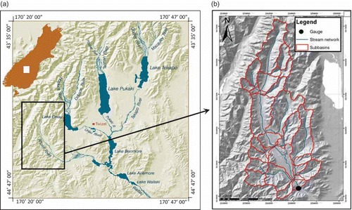
The river forming the southern boundary of the UWB, the Ahuriri, is one of the last major rivers in the basin that has not been altered as part of the HEP development and is still free flowing (Fig. 1). The upper catchment has an area of approx. 560 km2 and ranges in elevation from approx. 600 to 2200 m above sea level. It is semi-arid with precipitation varying from approx. 500 mm near Omarama to 6400 mm in the highest headwaters near the main divide of the Southern Alps. Based on Landcare Research New Zealand Soils and Land Environments of New Zealand databases, land cover in the catchment is 46% tussock grasslands, 31% low- and high-producing grasslands (with some pastoral sheep grazing), and 17% alpine gravel and rock (Landcare Research Citation2010). Soils in some areas of the valley floor tend to be highly saturated forming wetland habitats, while higher elevations are periodically snow covered with a small percentage of permanent snow and ice and several small glaciers, the largest of which is the Thurneysen Glacier. Mean annual flow is approx. 23.3 m3/s at a NIWA flow gauging station (Ahuriri at South Diadem, number 71116, ) located in the gorge at the outlet of the upper catchment study reach, based on the 46-year record (1963–2009) ((b)). The river exhibits considerable flow seasonality with the greatest flows in spring due to snowmelt. The flood season extends from late spring until mid-summer. Flood-plain pest plants include exotic Crack Willows and Russell Lupins that out-compete native low lying vegetation, and can stabilise banks and islands, promoting the development of a single channel instead of the dynamic braided river patterns that form in the presence of native plant species (Murray and Paola Citation2003). This invasive vegetation also has severe negative impacts on birds and other fauna that rely on bare, shifting gravels for habitat, including providing cover for introduced pest mammalian predators such as weasels, stoats and feral cats that decimate bird populations in many areas of New Zealand (Caruso Citation2006).
Table 1 Summary flow statistics for the Upper Ahuriri River at South Diadem gauge (period of record 1963–2009)
Fig. 1 Location map of (a) the Upper Waitaki River Basin major hydrological features and (b) HEC-GeoHMS catchment map showing the extent of the Ahuriri River, major tributaries, and 31 sub-basins used in the HEC-HMS model.
METHODOLOGY
The NIWA flow gauging station on the Ahuriri River is located 19 km west of the Omarama Township. Mean, minimum and maximum daily flow data from September 1963 to September 2009 were used for this study. Summary statistics including the mean annual flow, mean annual flood, mean annual low flow, and mean annual 7-day low flow, were calculated from the historical data to provide initial insight into the hydrology of Ahuriri catchment and river (). All annual statistics were based on the hydrological year used in the Southern Hemisphere (1 June–31 May) by Environment Canterbury, the regional council responsible for river monitoring (in conjunction with NIWA) and management.
The fit of the annual maxima series to 15 theoretical probability distributions was evaluated using the Kolmogorov-Smirnov and Anderson-Darling goodness-of-fit tests. The five distributions with the best fit were selected for further analysis. These included those of the extreme value family and the lognormal distribution. The GEV distribution has been widely used in the estimation of flood magnitudes (Stedinger et al. Citation1993). The GEV cumulative distribution function is defined as:
Rainfall–runoff hydrological model
Input data
The rainfall–runoff hydrological model for the catchment was developed using HEC-HMS (USACE Citation2010). This is a lumped, event-based model that has been widely used and verified in the USA and other countries, but its validity in many New Zealand catchments, particularly mountain tussock grassland catchments, is unknown. HEC-GeoHMS, an ArcGIS 9.3-based utility tool for HMS, was used to convert a DEM of the area into a HEC-HMS catchment map and stream network ((b)). This stream network was manually adjusted so that it matched the location and extent of the Ahuriri River and all its major tributaries as they are shown in 1:50 000 scale topographical maps and aerial photographs of the area. HEC-GeoHMS defines a sub-basin for each tributary and reach of the Ahuriri River, and calculates the area and average slope for each of these sub-basins.
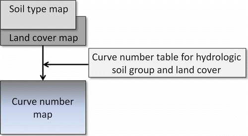
The HEC-HMS model includes a number of options for modelling hydrological processes. The Soil Conservation Service (SCS; now Natural Resources Conservation Service) runoff Curve Number method (USDA Citation2004) was used for loss and runoff estimates as it was considered the most appropriate method for the available catchment data, but it also required further testing and evaluation in New Zealand mountain environments. The curve number map required for the SCS loss method was generated within HEC-GeoHMS using soil type and land-cover maps obtained from Soils and Land Environments of New Zealand databases (Landcare Research Citation2010). These two maps were joined to create a layer with polygons defining each hydrological soil group and land-cover combination (). Curve numbers are defined for a variety of land-cover types overlaying four different hydrological soil groups (A, B, C and D) (USDA Citation2004). Hydrological soil group A is generally the most pervious with the lowest curve numbers and runoff quantities, while group D is the most impervious with the greatest curve numbers and amount of runoff. Defining the hydrological soil group for soils in the Ahuriri River catchment was straight forward; however, the land-cover data were developed primarily for the USA and therefore many of the land-cover types present in the Ahuriri River catchment were not explicitly defined. Tussock, sub-alpine grassland and low scrub dominate the catchment. Curve numbers for arid and semi-arid rangelands were therefore used for most polygons, including the herbaceous cover type (mixture of grass, weeds and low-growing brush, with brush the minor element), that were deemed to exhibit roughly similar biophysical and runoff characteristics. For initial model development and calibration, a fair hydrological condition was assumed for most land cover types. Curve numbers ranged from approx. 50 to 98 (for roads and paved areas, etc.) with a mean of 68. Each sub-basin was assigned a single curve number using an area-weighted average for both land-cover types and hydrological soil groups.
Fig. 2 Schematic flow chart for runoff curve number mapping for input to HEC-HMS.
A time step of 15 minutes was used for the model. The model calculated initial abstraction values based on the curve numbers. Transformation using the SCS Unit Hydrograph method produced a unit hydrograph for each sub-basin based on the sub-basin lag time calculated in HEC-GeoHMS. Constant monthly baseflows were approximated by estimating a monthly baseflow at the gauge (8 m3/s) and distributing this baseflow over the sub-basins relative to their area by assuming that each point in the catchment contributes equally. Channel routing was performed using the Muskingham-Cunge method, and channel slope and length were imported directly from HEC-GeoHMS. Channel shape and dimensions were determined during a field visit in August 2010. A rectangular cross-section for all channel reaches was assumed based on visual observation of accessible reaches to allow the channel width of inaccessible sections to be estimated from aerial images. Channel depths were measured for the accessible tributaries but had to be visually estimated for the main channel as it was too deep to measure manually. For inaccessible areas, the channel depth was estimated based on other reaches with similar characteristics.
Model calibration
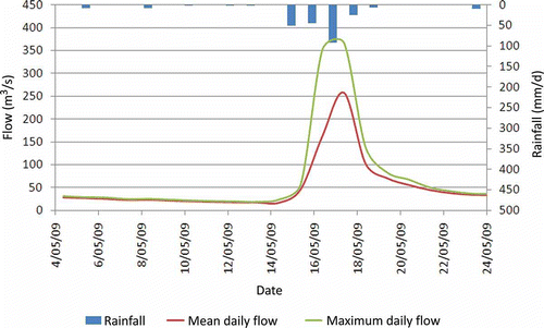
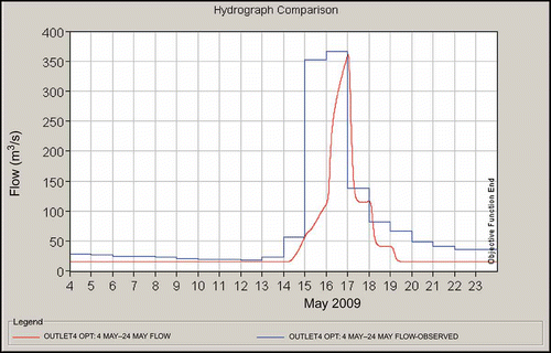
The model requires an input precipitation series either as a frequency-based event or as a user-defined hyetograph. The individual storms used as input for flood simulations, including calibration and validation, were based on a 24-h time of concentration as calculated within HEC-GeoHMS. This is relatively long for a mountainous catchment, but can partly be explained by the long, narrow geometry of the basin. A storm that occurred in May 2009 over four days was chosen for calibration because of its size and timing (). This was a very recent storm so catchment and river conditions were representative of current conditions. The precipitation depth (219 mm over four days) was also close to the 20-year precipitation event depth, which was useful to calibrate for modelling the large floods of interest.
Fig. 3 Calibration storm (14–18 May 2009) used for the Ahuriri River catchment HEC-HMS model.
Model calibration was performed using the historical flow record from the Ahuriri South Diadem gauge and precipitation data from the nearby Lake Ohau meteorological station. The gauge location discharges to the wider braided-river flood plain downstream where information on the effects of flood peaks on flood-plain ecology is needed for management. As for most gauged locations in New Zealand and other parts of the world, only daily flow values were available, and the maximum daily values were used for calibration. Data with finer temporal resolution were not available for this study.
Although HEC-HMS has a built-in optimization feature for calibration, this method did not produce satisfactory results so manual calibration was performed by varying key parameters, including curve numbers and Manning's n, to attempt to match the observed data by visual comparison of the hydrographs. Manning's n values were obtained from Hicks and Mason (Citation1998) and based on visual observations during the August 2010 field visit to the catchment. A roughness coefficient of 0.037 was considered appropriate for the river, but this parameter was varied during calibration due to the uncertainties in this value. Two objective functions were used to measure the error in the modelled peak flood flow relative to the observed peak flow used for calibration: the root mean square error (RMSE) and the per cent error in peak flow (PEPF) (USACE Citation2010).
Model validation and evaluation
After acceptable calibration, a longer precipitation record for the period 1 June to 30 September 2009 was used and the model was run as part of validation of results at the gauge location. As for calibration, the RMSE and PEPF were used as objective functions for analysis of validation errors for the flood peaks observed during this period. The model was also run for a number of frequency-based storms for ARIs of interest (2-, 10-, 20-, 50- and 100-years, or 0.5, 0.2, 0.1, 0.05, 0.02 and 0.01 annual exceedence probabilities (AEP), respectively) using the NIWA High Intensity Rainfall Design System (HIRDS). HIRDS is a nationwide database that uses isohyets to predict the precipitation intensity for a number of ARIs. A storm duration of 24 h was used to approximately match the time of concentration of the catchment. For each ARI of interest, a synthetic storm distribution was created using the total precipitation depth and a 15-min time step over the 24-h storm, assuming that the greatest precipitation intensity occurs half way through the storm duration. A 500-year storm was not available in HIRDS, so the 500-year flood values estimated from the statistical distributions were not compared to the HEC-HMS results. These values were only used to show the spread of the statistical estimates and the potential uncertainty associated with this large flood.
A hydrograph, peak flows and total flow volumes for each sub basin were obtained for each modelled storm. Modelled flood peaks were compared directly to the statistical estimates for the flood peaks to evaluate the performance of the models for the flood events of interest. In addition to the RMSE and PEPF used as objective functions for validation of the flood peaks, the coefficient of determination (R 2) based on linear regression was computed for comparison of all the modelled flood peaks with the statistical peaks. Both the statistical and model results were also compared to other sources of information on flood magnitudes and frequencies for the Ahuriri River and catchment, including a South Canterbury regional study by Pearson (Citation1991) and associated flood quantiles, and the NIWA Water Resources Explorer New Zealand (WRENZ; NIWA Citation2007). A sensitivity analysis was also performed to help to determine which parameters have the greatest influence on the model results by changing a selected parameter while leaving all other parameters constant. Parameters analysed were the SCS curve number, Manning's n, and channel dimensions.
RESULTS AND DISCUSSION
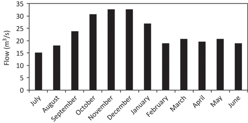
The Ahuriri River catchment exhibits a fast response to precipitation events in a manner similar to other mountainous catchments (Kostka and Holko Citation2002, Weingartner et al. Citation2003). Based on the historical record, the Upper Ahuriri River mean annual maximum flow (mean annual flood) is 175 m3/s, which is approximately 20 times greater than the mean annual minimum flow (8.5 m3/s) (). The maximum recorded flood (570 m3/s) is 24 times greater than the mean annual flow. This range in flows demonstrates the large variation that can be expected in mountainous catchments such as the Ahuriri (Pearson Citation1995, Bales et al. Citation2006). A plot of the mean monthly flows shows the annual variation of flows in the Ahuriri River (). Peak flows occur between mid-spring and mid-summer as a result of snowmelt, while low flows generally occur in late summer, when there is little rainfall, and in autumn and winter, when a significant portion of precipitation in the catchment falls as snow that is retained in the catchment until the spring melt. On average, peak (maximum daily) flows during floods are more than 30% greater than the mean daily flow in the Ahuriri River.
Fig. 4 Mean monthly flows for the Ahuriri River at the South Diadem gauge (1963–2009).
Statistical analysis and probability distributions
The historical flood peak data based on the Gringorton plotting position fit the five theoretical probability distributions reasonably well (). Both the Kolmogorov-Smirnov and Anderson-Darling goodness-of-fit tests indicated that the observed data fit the GEV and lognormal distributions best. The Frechet distribution was ranked third. The distribution parameters and estimated flood flows for the GEV and lognormal distributions are given in . These two distributions fit the observed data relatively well up to the 100-year flood. Beyond this there is more variation among all the distributions. Based on the Gringorton plotting position, the largest flood on record of 570 m3/s is approximately an 82-year flood, while both the GEV and lognormal distributions indicate that this peak is approximately a 50-year event.
Table 2 Parameters for the two best-fitting distributions, flood peak estimates (m3/s), and the average values of the two distributions
Fig. 5 Plot of comparison of estimated flood magnitudes and return periods for the five best fitting probability distributions for the Ahuriri River flood data.
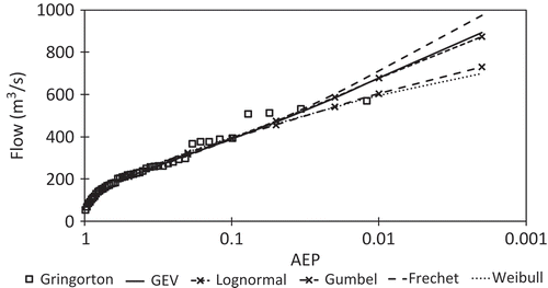
McKerchar and Pearson (Citation1990) suggest that the Gumbel (EV1) distribution is best for at-site estimation of flood frequency in New Zealand and, in particular, the 2-parameter Gumbel distribution is generally more appropriate because it has smaller errors for short records. A subsequent study by Pearson (Citation1991), investigating regional flow distributions using L-moments, showed that South Canterbury is a reasonably homogeneous region. Catchments in South Canterbury, including the Ahuriri River catchment, do not fit this generalization and are instead best modelled by the Frechet (EV2) distribution (Pearson Citation1991). These regional studies also provided a set of regional quantiles that can be applied to any catchment in the region by multiplying the mean annual flood of that catchment and the regional quantile for the required return period (McKerchar and Pearson Citation1990, Pearson Citation1991, Pearson and Henderson Citation2004). Expected flood flows for the Ahuriri River based on the regional quantiles are slightly higher than those estimated using the statistical analysis and probability distributions in this study. There are a number of factors that could contribute to this difference. The regional quantiles are based on catchments throughout the South Canterbury region and thus a much larger data set was used which could provide a more accurate analysis. However, the Ahuriri River catchment could display a different precipitation–runoff response from other South Canterbury catchments. In addition, the flow record used in this study was 20 years longer and more recent than the previous regional analysis. The flow record could exhibit some non-stationarity with changing conditions, such as climate variation or short- or long-term changes, making the at-station estimates derived in this study more accurate.
Rainfall–runoff hydrological model
Model calibration
Manual calibration of the model resulted in an acceptable fit to observed data for the calibration storm event. An increase of the initial curve numbers by approximately 10% resulted in the most accurate fit to the observed data (). Observed peak flow was higher than the modelled flow on 16 May, but the modelled peak flow (361 m3/s) matched the greatest observed peak (366 m3/s) very well on 17 May. The calibration objective function analysis resulted in a PEPF of only 1% and a RMSE of 3.5. Modelled flows on the receding limb of the hydrograph were also somewhat lower than observed maximum values. However, the primary objective of modelling with HEC-HMS was to simulate peak flood flows to provide information on effects on flood-plain ecology for management, not to reproduce the entire flood hydrograph. Although a number of other parameters were modified as part of the calibration, there was very little variation in model output.
Fig. 6 HEC-HMS model calibration results showing the Ahuriri River observed and modelled flow for the calibration event.
Validation and comparison of modelled flood peaks with statistical estimates
Over the initial, longer validation period (1 June–30 September 2009) modelled flows matched observed values reasonably well (). There were two primary flood peaks observed during the validation period that occurred less than a week apart. The validation objective function analysis for these peaks resulted in PEPF values of 5–26% and RMSE values of 4.9–13.4. The model performed better (122 m3/s) for the larger observed peak (129 m3/s), but overestimated the smaller peak (modelled 93 m3/s versus observed 74 m3/s). Validation and comparison of modelled flood peaks with statistical estimates showed that the calibrated model performed fairly well for most flood events (, ). The RMSE for all flood peaks was 84.6, and the PEPF ranged from 3% to 28%. Model results were very close to observed values based on the Gringorton plotting position for smaller events, and then underestimated these values until beyond the 25-year flood. The modelled peak for the approximate 82-year flood was considerably greater (approx. 750 m3/s) than the largest observed flood (570 m3/s) assigned that ARI using the plotting position. Based on HEC-HMS and statistical estimates of precipitation inputs, the 570 m3/s flood was approximately a 36-year event. It was estimated to be approximately a 48-year event based on the GEV distribution, and a 44-year flood using the lognormal distribution. Model results were close to statistical estimates based on the mean of the GEV and lognormal distributions, but underestimated them somewhat (by –3 to –11%), up to approximately the 25-year flood. Beyond that event, model results were higher than the statistical estimates (+11% for the 50-year flood peak and +28% for the 100-year flood). However, on average for all events, modelled flood peaks were only 1% higher than the statistical estimates. The R2 value based on linear regression for all flood peaks was 0.79.
Table 3 Summary of comparison of HEC-HMS model results to statistical and other estimates for all flood peaks evaluated in this study (m3/s). PEPF (Per cent Error in Peak Flow) compares HEC-HMS peak to statistical mean peak. ARI is annual recurrence interval (years) and AEP is annual exceedence probability
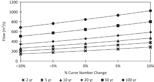
Adjusting curve numbers during the calibration process and as part of the sensitivity analysis showed that the curve numbers had a significant influence on model results. An approximate 10% increase from the original curve number estimates was required to calibrate the model. Increases and decreases (±5% and ±10%) of curve numbers from calibrated values were also performed to evaluate the sensitivity of the model and simulated flood flows to this parameter (, ). Curve number increases of 5% led to increases of modelled flood peaks ranging from 11% for the 100-year flood to 18% for the 2-year event, while increases of 10% resulted in greater modelled peaks ranging from 21% to 37% for the 100-year and 2-year floods, respectively. Decreases in curve numbers were not quite as large, with 5% decreases resulting in lower modelled flood peaks ranging from –9% for the 100-year event to –15% for the 2-year flood. Ten per cent decreases caused decreases of modelled peaks ranging from –19% to –30% for the 100-year and 2-year floods, respectively. Therefore, relatively small changes in curve numbers had the greatest effects on smaller modelled flood estimates, but still had considerable impacts on larger floods.
Table 4 Sensitivity analysis results of per cent change in curve numbers with resulting proportion change in modelled flood peaks. ARI is annual recurrence interval and AEP is annual exceedence probability
Fig. 9 Results of the curve number sensitivity analysis showing the significant increase in flows observed as the curve number increased.
The peak flood flows generated by the calibrated HEC-HMS model compare favourably to the expected flows from the regional analysis undertaken by Pearson (Citation1991) (). The modelled flood peaks are somewhat greater than the regional estimates up to the 25-year event, and then are slightly lower than, but very close to, the 100-year flood. However, the WRENZ program gives a mean annual flood of 254 m3/s and a 100-year flood of 690 m3/s (). These are 18% higher than the 2-year flood and 5% higher than the 100-year flood estimated with the statistical distributions. The 2-year and 100-year modelled flood peaks are 17% lower and 22% higher than the respective WRENZ values.
Results show that the 2-year flood for the Upper Ahuriri River may range from 210 to 216 m3/s based on modelled and statistical estimates. The regional estimate is considerably lower than these values and is likely less accurate than the at-station estimates. The 20-year flood estimates are all very close, in the range of 451 to 478 m3/s, including the regional estimate. The 50-year flood ranges from 641 to 665 m3/s, while the 100-year flood may range from 658 to 844 m3/s, with the regional estimate somewhat higher than this.
Very few studies exist for comparison of modelled flood estimates for high country mountain catchments in New Zealand that are not regulated by dams and/or lakes and reservoirs. Comparison of our results to estimates derived from WRENZ for other selected nearby rivers with somewhat similar catchment areas and in either rather similar or quite different environments shows some interesting results (). The Ahuriri River has the second lowest mean annual flow (MAF) after the Orari River at the gorge, which originates in the drier eastern foothills of the Southern Alps. The Ahuriri flow is very similar to the Dobson River, which has a smaller catchment. MAF is greatest for the Tasman (which has a larger catchment) and Landsborough (on the west coast) rivers. This is due to either much greater precipitation or more snow and glacier cover/melt within their catchments.
Table 5 Comparison of Ahuriri River flood information with other selected nearby rivers with similar drainage areas. Data for all other rivers derived from WRENZ estimates. Rivers drain the east slope of the Southern Alps from north to south with the exception of the Landsborough River above the Clark River on the West Coast and the Orari River at the gorge in the eastern foothills, for comparison purposes
The Ahuriri River also has the second smallest mean annual flood after the Ashburton River South Branch (SB), which is considerably less but originates in a dry inter-montane basin (Ashburton Lakes) just below the Southern Alps divide that likely mediates flood flows. With regard to the estimated 100-year flood (1% AEP flood), the Ahuriri River has the third lowest after the Ashburton SB and Dobson rivers. These differences are again likely due to less precipitation, snowmelt in spring, or rain on snow effects, but it is somewhat surprising that even the Orari River appears to have greater flood peaks.
The Ahuriri River has the second lowest ratio of the mean annual flood to MAF (after the Ashburton SB), although it is very similar to the Rangitata River above Potts River. Surprisingly the value for the Orari River is much higher than all others, but the west coast Landsborough and Dart rivers are also high. For the ratio of the 100-year flood to MAF, the Ahuriri River is intermediate between most rivers with the Ashburton SB having the lowest value and the Orari River having a much higher value. On a more comparable specific discharge basis (discharge/km2), the Ahuriri River has the second lowest specific mean annual flood and specific 100-year flood after the Ashburton SB. The Landsborough River on the West Coast has much higher values than all others.
The greatest flood (570 m3/s) on record (45 years) at the Ahuriri River gauge was estimated to be somewhere between a 35- and 50-year event based on both the statistical and modelling estimates. Other studies have used these hydrological modelling results as input to a hydraulic model, in conjunction with interpretation of historical aerial photographs taken before and after this flood event, to evaluate potential changes in riparian vegetation due to this flood. Preliminary results indicate that this flood likely removed 10 to 20% of the vegetation and pest plants in some areas of the downstream flood plain, but that much of this regenerates relatively rapidly to re-occupy similar or other areas, resulting in only small changes after a year or longer periods.
CONCLUSIONS AND RECOMMENDATIONS
The Ahuriri River catchment is a good example of a mountain catchment exhibiting both highly variable flows and a fast response to precipitation events. Historical flood data are well modelled by both the GEV and lognormal distributions up to the 100-year flood event. The HEC-HMS model also produced good estimates of various ARI flood peaks of interest based on acceptable calibration, validation and comparison to the statistical estimates. Over all flood events, the average difference between hydrological model and statistical peak flow estimates was only 1%. However, the rainfall–runoff model tended to underestimate the smaller flood peaks somewhat and to overestimate the larger floods relative to the observed values (based on the Gringorton plotting position) and the statistical estimates. Model results were also generally consistent with NIWA regional estimates based on L-moments and the WRENZ system. Other hydrological models, such as TOPNET developed by NIWA and used in New Zealand, should be applied and tested in this and similar high country catchments for comparison purposes.
Although the Ahuriri River has highly variable flows, this study has shown that this high country mountain catchment dominated by tussock grasslands has a small mean annual flow and small flood peaks compared to many other rivers originating in or near the Southern Alps. A flood considerably larger than the largest event on record would likely be required to remove a significant proportion of flood-plain pest plants with long lasting impacts. Modelling such large floods will continue to be a challenge due to data limitations, potential nonstationarity due to global climate change and additional human impact, and the large uncertainty in statistical and deterministic model estimates.
Acknowledgements
We would like to thank Chris Woolmore, PRR Project Manager with the Department of Conservation, who provided valuable knowledge on the Ahuriri River catchment. We also thank NIWA for providing all historic discharge data from the South Diadem gauge.
REFERENCES
- Al Fugura , A. 2011 . Coupling of hydrodynamic model and aerial photogrammetry-derived digital surface model for flood simulation scenarios using GIS: Kuala Lumpur flood, Malaysia . Disaster Advances , 4 ( 4 ) : 20 – 28 .
- 1999 . Guidelines for stormwater runoff modelling in the Auckland Region , Auckland : Beca Carter Hollings and Ferner Ltd., Technical Publication no. 108 . ARC (Auckland Regional Council)
- Bales , R.C. 2006 . Mountain hydrology of the western United States . Water Resources Research , 42 et alW08432, 13doi:10.1029/2005WR004387
- Bandaragodaa , C. , Tarboton , D.G. and Woods , R. 2004 . Application of TOPNET in the distributed model intercomparison project . Journal of Hydrology , 298 : 178 – 201 .
- Baron , J.S. and Williams , M.W. 2000 . Preface, recent Loch Vale watershed research . Water Resources Research , 36 : 1 – 12 .
- Beven , K. 1995 . “ Topmodel. In ” . In Computer models of watershed hydrology , Edited by: Singh , V.P. 627 – 668 . Highlands Ranch , CO : Water Resources Publications .
- Beven , K.J. and Kirkby , M.J. 1979 . A physically based variable contributing area model of basin hydrology . Hydrological Sciences Bulletin , 24 ( 1 ) : 43 – 69 .
- Caruso , B.S. 2006 . Project River Recovery: Restoration of braided gravel-bed river habitat in New Zealand's high country . Environmental Management , 37 ( 6 ) : 840 – 861 .
- Clark , M.P. 2008 . Hydrological data assimilation with the ensemble Kalman filter: use of streamflow observations to update states in a distributed hydrological model . Advances in Water Resources , 31 : 1309 – 1324 .
- Davie , T.J.A. , Fahey , B.D. and Stewart , M.K. 2006 . Tussock grasslands and high water yield: a review of the evidence . Journal of Hydrology (NZ) , 45 ( 2 ) : 83 – 94 .
- Di Baldassarre , G. 2010 . Flood-plain mapping: a critical discussion of deterministic and probabilistic approaches . Hydrological Sciences Journal , 55 ( 3 ) : 364 – 376 .
- Waikato , Environment . 2009 . Impacts of land use change on floods in the Upper Waikato, Phase 2: model calibration and flood hydrograph generation , Auckland : Sinclair Knight Merz final report .
- Fahey , B.D. and Watson , A.J. 1991 . Hydrological impacts of converting tussock grassland to pine plantations, Otago New Zealand . Journal of Hydrology (NZ) , 30 : 1 – 15 .
- Henderson , R.D. , Ibbitt , R.P. and McKerchar , A.I. 2003 . Reliability of linear regression for estimation of mean annual low flow: a Monte Carlo approach . Journal of Hydrology (NZ) , 42 ( 1 ) : 75 – 95 .
- Hicks , D.M. and Mason , P.D. 1998 . Roughness characteristics of New Zealand rivers. National Institute of Water and Atmospheric Research , Littleton , CO : Water Resources Publications .
- Junghans , N. , Cullmann , J. and Huss , M. 2011 . Evaluating the effect of snow and ice melt in an Alpine headwater catchment and further downstream in the River Rhine . Hydrological Sciences Journal , 56 ( 6 ) : 981 – 993 .
- Kia , M.B. 2012 . An artificial neural network model for flood simulation using GIS: Johor river basin, Malaysia . Environmental Earth Sciences (Article on-line first available) , et aldoi:10.1007/s12665-011-1504-z
- Klemes, V., 1990. The modelling of mountain hydrology: the ultimate challenge. In: Ĺ. Molnàr, ed. Hydrology of mountainous areas (Proceedings of the Strbske Pleso Workshop, Czechoslovakia, June 1988). Wallingford: IAHS Press, IAHS Publ. 190, 29–43. Available at:[Accessed 2 February 2011]. http://www.iahs.info.redbooks/190.htm (http://www.iahs.info.redbooks/190.htm)
- Kostka , Z. and Holko , L. 2002 . “ Analysis of rainfall–runoff events in the mountain catchment ” . In Slovak IHP UNESCO/IH SAS:10-13
- Landcare Research, 2010. Land resource information system portal [online]. Available from:[Accessed March 2010]. http://lris.scinfo.org.nz/#/layers/global/oceania/new-zealand (http://lris.scinfo.org.nz/#/layers/global/oceania/new-zealand)
- Leavesley , G.H. 1983 . “ Precipitation runoff modeling system—user's manual ” . In US Geological Survey Water Resources Investigation Report 83-4238. Denver, CO: US Geological Survey
- Leavesley , G.H. and Stannard , L.G. 1995 . “ Precipitation Runoff Modeling System – PRMS. In ” . In Computer models of watershed hydrology , Edited by: Singh , V.P. 281 – 310 . Highlands Ranch , CO : Water Resources Publications .
- Lu , X.F. 2009 . Simulation of the Upper Waimakariri River catchment by observed rain and radar reflectivity , Unpublished thesis (Master of Applied Science). Lincoln University .
- McKerchar , A.I. and Pearson , C.P. 1990 . Maps of flood statistics for regional flood frequency analysis in New Zealand . Hydrological Sciences Journal , 35 ( 6 ) : 609 – 621 .
- MfE (Ministry for the Environment) . 2010 . “ Tools for estimating the effects of climate change on flood flow, a guidance manual for local government. In: R. Woods, et al ” . In National Institute for Water and Atmospheric Research , New Zealand : Prepared for Ministry for the Environment .
- Murray , A.B. and Paola , C. 2003 . Modelling the effect of vegetation on channel pattern in bedload rivers . Earth Surface Processes and Landforms , 28 : 131 – 143 .
- NIWA (National Institute for Water and Atmospheric Research), 2007. Water resources explorer New Zealand [online]. Available from:[Accessed 22 January 2011]. http://wrenz.niwa.co.nz/webmodel/ (http://wrenz.niwa.co.nz/webmodel/)
- Pearson , C.P. 1991 . New Zealand regional flood analysis using L-moments . Journal of Hydrology (NZ) , 30 ( 2 ) : 53 – 64 .
- Pearson , C.P. 1995 . Regional frequency analysis of low flows in New Zealand rivers . Journal of Hydrology (NZ) , 33 ( 2 ) : 94 – 122 .
- Pearson , C.P. and Henderson , R. 2004 . “ Flood and low flows. In ” . In eds. Freshwaters of New Zealand , Edited by: Harding , J. Wellington : New Zealand Hydrological Society and New Zealand Limnological Society .
- Petrow , T. 2007 . Aspects of seasonality and flood generating circulation patterns in a mountainous catchment in south-eastern Germany . Hydrology and Earth System Sciences , 11 ( 4 ) : 1455 – 1468 .
- Pradhan , B. 2010 . Flood susceptible mapping and risk area estimation using logistic regression, GIS and remote sensing . Journal of Spatial Hydrology , 9 ( 2 ) : 1 – 18 .
- Pradhan , B. and Shafie , M. 2009 . Flood hazard assessment for cloud prone rainy areas in a typical tropical environment . Disaster Advances , 2 ( 2 ) : 7 – 15 .
- Pradhan , B. and Youssef , A.M. 2011 . A 100-year maximum flood susceptibility mapping using hydrological and hydrodynamic models: a case study . Journal of Flood Risk Management , 4 : 189 – 202 . doi: 10.1111/j.1753-318X.2011.01103.x
- Sayama , T. 2012 . Rainfall–runoff-inundation analysis of the 2010 Pakistan flood in the Kabul River basin . Hydrological Sciences Journal , 57 ( 2 ) : 298 – 312 .
- Stedinger , J.R. , Vogel , R.M. and Foufoula-Georfiou , E. 1993 . “ Frequency analysis of extreme events. In ” . In Handbook of hydrology , Edited by: Maidment , D. New York : McGraw Hill .
- 2007 . Acacia Heights Catchment Management Plan (Draft for consultation) , : 122107- – 02 . Taupo District CouncilHG Ref 1013-
- 2010 . Hydrologic Modelling System HEC-HMS Users Manual, Version 3.5 , Davis , CA : Hydrologic Engineering Center, US Army Corps of Engineers . USACE (US Army Corps of Engineers)
- 2004 . National engineering handbook, Part 630 – Hydrology , Washington , DC : Natural Resources Conservation Service . USDA (US Department of Agriculture)
- Vergara , W. 2011 . Assessment of the impacts of climate change on mountain hydrology: development of a methodology through a case study in the Andes of Peru , New York : World Bank .
- Viviroli , D. 2011 . Climate change and mountain water resources: overview and recommendations for research, management and policy . Hydrology and Earth Systems Sciences , 15 : 471 – 504 .
- Weingartner , R. , Barben , M. and Spreafico , M. 2003 . Floods in mountain areas—an overview based on examples from Switzerland . Journal of Hydrology , 282 : 10 – 24 .
- Wohl , E. 2000 . Mountain rivers , Washington , DC : American Geophysical Union .
- Youssef , A. , Pradhan , B. and Hassan , A.M. 2011 . Flash flood risk estimation along the St. Katherine road, southern Sinai, Egypt using GIS based morphometry and satellite imagery . Environmental Earth Sciences , 62 ( 3 ) : 611 – 623 . doi: 10.1007/s12665-010-0551-1