Abstract
The annual water balance of Lake Kyoga is estimated by a comparison of upstream and downstream flows in the Nile channel during a period of reliable measurements (1940–1977), supported by rainfall records over the basin. The relative contributions of net lake rainfall and tributary inflows are estimated. Changes in annual rainfall and seasonal distribution are examined.
Editor Z.W. Kundzewicz
Citation Brown, E. and Sutcliffe, J.V., 2013. The water balance of Lake Kyoga, Uganda. Hydrological Sciences Journal, 58 (2), 342–353.
Résumé
Le bilan annuel du lac Kyoga a été établi en utilisant les débits du Nil en amont et en aval du lac pendant une période de mesures fiables (1940–1977), ainsi que les archives des précipitations sur le bassin versant. Les contributions des précipitations nettes sur le lac et les débits des affluents ont été estimées. Les variations des précipitations annuelles et leur distribution saisonnière ont été étudiées.
Citation Brown, E. and Sutcliffe, J.V., 2013. The water balance of Lake Kyoga, Uganda. Hydrological Sciences Journal, 58 (2), 1–12.
INTRODUCTION
The Lake Kyoga basin is perhaps the least studied of the Nile tributaries, but is an important link between Lake Victoria and Lake Albert, and influences flow into South Sudan. The main reason for this has been the lack of precise flow measurements. The records of Nile flow above and below the lake are not equally long and precise, and the complex pattern of tributaries draining into the different arms of the lake has led to a shortage of information about the long-term contribution of the basin itself. Lake Kyoga has been regarded as a cause of delays and losses in flows between Lake Victoria and Lake Albert, with local inflows resulting in gains in some years. With increasing interest in the control and resources of the White Nile, available records have been used to improve our knowledge of the water balance of the lake basin, and of flows in the Kyoga Nile over a longer period.
THE BACKGROUND
The topography of Lake Kyoga is a product of regional tectonic history (Rushdi Said Citation1993). The present Kyoga basin () was once drained by the Kafu River, which received runoff from Mount Elgon and flowed west into the Ubangi branch of the River Congo. After the formation of the western branch of the Rift Valley, the Kafu channel divided into two parts, one flowing into Lake Albert, formed as one of a series of lakes in the floor of the Rift, and the other reversing the channel flow east towards Lake Kyoga. Lake Victoria emerged within the two arms of the Rift Valley and spilled some 12 500 years ago into a relatively steep channel from Jinja to the Kafu, and along other tributaries of the Kafu towards Lake Albert and the White Nile. This gave rise to the dendritic shape of Lake Kyoga along the former tributaries of the Kafu, and resulted in a relatively shallow lake with swampy arms whose areas are relatively limited (Hurst and Phillips Citation1938). The major inflows and outflows derive from the outflow from Lake Victoria, but the local tributaries drain an effective area of some 57 000 km2.
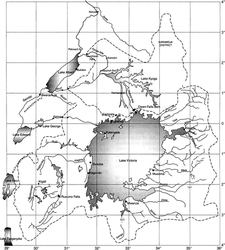
Fig. 1 Map of the East African lake region (after Sutcliffe and Parks 1999).
The eastern limit () of the basin follows the Uganda–Kenya boundary from Lake Victoria through Mount Elgon and the western edge of the Eastern Rift as far as the border of South Sudan (Green Citation2009). Although numerous streams flow off Mount Elgon, the northeastern part of the basin comprises the dry plains of Karamoja, which only contribute significantly to the lake in exceptional years. The stream network shows that the eastern tributaries flow into a number of satellite lakes and swamps before contributing to Lake Kyoga. The proportions of open water and papyrus swamp (Cyperus papyrus) within the main lake have varied over time, and the lake has recently been invaded by water hyacinth (Eichhornia crassipes). The number of tributaries discharging into different arms of the lake makes it difficult to estimate the local inflow, but measurements were made by the WMO survey (WMO Citation1974) and continued to the late 1970s. Measurements have been resumed by the Uganda authorities in recent years.
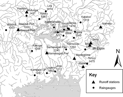
Fig. 2 Lake Kyoga region, including runoff stations and raingauges.
EARLIER STUDIES
A preliminary water balance was estimated by Hurst and Phillips (Citation1938). They measured the area of the lake from maps as 1760 km2 of open water and 4510 km2 of swamps; they noted that the total area is fairly constant but the proportions vary from time to time. They compared the 1913–1932 average inflow (20.5 km3) with outflow at Masindi Port (18.0 km3) and deduced an annual loss of 2.5 km3. They compared the direct rainfall on the lake of 1295 mm (8.1 km3) and local runoff at 3% of rainfall over an area of 69 000 km2 (2.7 km3) with an estimated lake evaporation of 1205 mm from the open water and 2230 mm from the swamp area (12.2 km3) and derived a net loss of 1.4 km3.
The World Meteorological Organization (1974) investigated the flows in 1969 and 1970 in a number of Lake Kyoga tributaries, and estimated the total inflow in a normal year as 2.04 km3 from gauged areas and 2.9 km3 including ungauged areas. A later estimate of total inflow, based on a main period of 1971–1977, was 2.01 km3.
The Institute of Hydrology (Citation1984) carried out an investigation of Lake Victoria and the Victoria Nile downstream. This included a comparison of Lake Kyoga inflows from Jinja and outflows at Masindi Port from 1912 to 1940 and at Kamdini from 1940 to 1977. While the average effect of Lake Kyoga appeared to be a small decrease in Nile flow, the results for several periods were deemed unrealistic.
In 1996, Sir Alexander Gibb and Partners analysed flows in the Kyoga Nile as part of a study of hydroelectric potential (Gibb Citation1996). As the rating curve at Masindi Port had proved unstable, analysis was concentrated on the flow record at Kamdini from 1940 to 1977. This confirmed that there had been net losses in a number of years between 1940 and 1960, and net gains in most years after 1961. An average monthly balance for a relatively dry decade and a wetter one, with estimated runoff coefficients, reproduced the main features of the water level regime (Sutcliffe and Parks Citation1999).
AVAILABLE RECORDS: RIVER FLOWS
The aim of this present study is to estimate local runoff from the available information and clarify the role of the Lake Kyoga basin in the Nile regime. The period from which the most reliable deductions can be made is determined by the availability of precise river flows at Kamdini, and is 1940–1977 (Gibb Citation1996). The outflows from Lake Victoria have been studied over a number of years. Until 1954 the outflows were controlled by the Ripon Falls, near Jinja, and the rating curve was based on gaugings downstream, extended by hydraulic analysis after the rise in Lake Victoria after 1961. After the construction of the Owen Falls dam in 1954, discharges were based on this rating curve, known as the Agreed Curve, but measurements were also available from the discharges from the dam. The series based on Institute of Hydrology (Citation1993) provides monthly flows from 1896 to 1995, derived from lake levels and the Agreed Curve, flows measured at Namasagali, and turbine/sluice releases.
There have been several river gauges established by the Egyptian Irrigation Service between Lake Kyoga and Lake Albert, but only two have a continuous level record supported by discharge measurements. The longer level record was at Masindi Port, which commenced in 1912, but discharge measurements at this site did not begin until 1940. An attempt was made by Hurst and Phillips (Citation1938) to derive a rating curve from a small number of gaugings made in 1922/23, 1932 and 1935 at Fajao downstream of the Murchison Falls, and related to measured levels at Masindi Port; a record was published of “Approximate monthly and annual mean discharges of the Victoria Nile below Lake Kioga” in The Nile Basin, vol. IV, 2nd Supplement (Hurst and Phillips Citation1939). Another rating was later used to revise the flows during the high levels of 1917–1918 (Hurst et al. Citation1953). Discharge measurements were carried out at Masindi Port by the Egyptian authorities from 1940 to 1945 and by Uganda from 1971 to 1978. Hurst et al. (Citation1946) concluded that regular discharge observations showed that the gauge was not a stable indicator of discharge. During a hydrological study for the World Bank (Gibb Citation1989) rating curves and flow records were derived for Masindi Port covering the period 1938–1978; the record was assessed as “good” in 1938–1945, “questionable” for 1946–1970 when gaugings were lacking, and “fair” in 1971–1978. The early records were not reproduced.
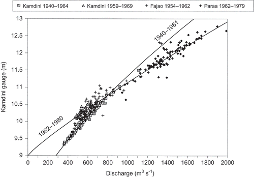
When the hydroelectric potential of Uganda was investigated in 1996, the more promising gauge at Kamdini was studied in detail (Sutcliffe Citation1996, Gibb Citation1996). A total of 334 gaugings between 1940 and 1979 at Kamdini, and at Fajao and Paraa downstream, were extracted from The Nile Basin and Ugandan archives. Because of the limited range of levels in single years, the rating was derived by the HYDATA program (Institute of Hydrology Citation1995) in the form Q = a(h – h 0) n from the whole set of gaugings, while annual deviations from the curve were used to deduce any changes in control h 0 from year to year. It will be seen from that there was a significant change in rating in 1961. The 10-day level record, and the rating curve adjusted each year from contemporary gaugings, were used to deduce a flow series from 1940 to 1977. This record should be reasonably precise.
Fig. 3 Gaugings at Kamdini, Fajao and Paraa, 1940–1979 (after Sutcliffe and Parks 1999).
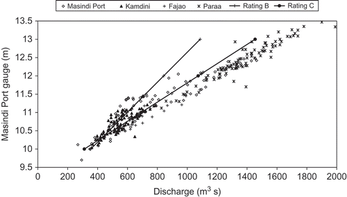
A corresponding plot of 310 gaugings at various sites below Lake Kyoga, nearly all between 1940 and 1978, related to gauge levels at Masindi Port, is shown in ; this includes the linear ratings used by Hurst and Phillips (Citation1938) to estimate the early flows (Rating B) and to revise the 1917–1918 flows (Rating C). This reveals that the rating at Masindi Port was less stable than that at Kamdini.
Fig. 4 Gaugings at Masindi Port, Kamdini, Fajao and Paraa, 1922–1978.
To measure the contribution of the Kyoga basin from the inflow into the many branches of the lake is not easy, and long-term records do not exist. The net basin supply can best be estimated by comparing the inflow and outflow in the Nile channel, which depends on the differences between two sets of large numbers. Because the early flows at Masindi Port are insufficiently precise for this purpose, a reliable estimate can be obtained only for the period 1940–1977, when the number of gaugings was adequate. The net basin supply can be calculated from the difference between outflow and inflow, allowing for changes in lake storage, and these are available for analysis.
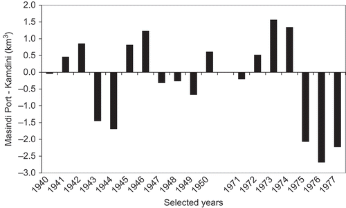
The question arises: what is the precision of these estimates? The rating curve is based on discharge measurements; the measurement practice followed in the Nile basin has been described by Hurst (Citation1952), and the average precision has been assessed by Hurst and Phillips (1932) to be about 5%. There is the additional error involved in deriving a curve from a number of gaugings; the annual number of gaugings used at Kamdini averages 8.6, but these were measured at different sites and may include extrapolation. However, it is possible in this case to deduce the standard error by comparing the records at Masindi Port and Kamdini, which are on the same channel. The standard deviation of the differences over the periods 1940–1950 and 1971–1977, when the flows were comparable and reasonably reliable (), is 1.30 km3, or 5% of the average flow of 26.0 km3. This precision should be borne in mind when comparing the net basin supply with basin rainfall. It explains the moderate precision of the derived relation between the two.
Fig. 5 Differences between annual flows at Masindi Port and at Kamdini, 1940–1977.
BASIN RAINFALL
A reasonable number of rainfall records are available in the Kyoga basin (Kigobe et al. Citation2011), and long-term monthly records provide a basis for estimating the input to the basin. Twenty stations are available from the 1996 study of the hydroelectric potential of the Nile in Uganda (Gibb Citation1996), which included a preliminary estimate of the contribution of the Kyoga basin. As summarised in Sutcliffe and Parks (Citation1999), eight of these stations were selected to compare with net gains from the basin.
In this study, further rainfall records were obtained. Early rainfall records were published in The Nile Basin, vol. VI and Supplements (Hurst and Black Citation1943). From both sources, 30 station records were assembled, but 24 stations were selected to give a reasonable coverage. In two cases, pairs of adjacent stations were combined to fill gaps, leaving 22 stations with reasonable long records. The records were appraised by comparison, especially with alternative sources. Some significant differences were noted, together with a number of small differences, attributed to the fact that the Nile Basin records would have been measured in inches and converted to mm before publication. Only three annual readings were rejected, which left 22 stations with an average of 50 years of records.
The positions of these rainfall stations are shown in , and the average annual rainfall for the whole period at each station is included. It will be noted that apart from the low value at Masindi Port, in the Nile channel below the lake, the numbers are fairly consistent over the main basin with fairly random variations. The mean annual rainfall for all station records is 1294 mm, which is a reasonable estimate of the average rainfall over the basin, excluding the dry area north of Katakwi which contributes little except in exceptional years.
The annual basin average rainfall, estimated from the average of annual totals at all available stations, is illustrated in (a). However, the number of stations contributing in each year ((b)) increases rapidly in the early years, reaches a plateau of 20 stations and decreases rapidly after 1980, when local conditions led to lack of observations. The data suggest that the inter-station correlation of annual rainfall totals is low. If one assumes that the annual observations are random measurements of a single value, the standard error of estimate is the standard deviation of the rainfall divided by the square root of the number of observations. This value is shown in (c), and is high in the early years, reaches a fairly steady value of about 50 mm, and then increases because of the decreasing station coverage. The period of reasonable estimates is between about 1915 and 1977, which happens to include the period when river flows are available. An alternative estimate of the annual basin rainfall has been calculated from the same data by the isopercentile method, which has the advantage of weighting the variations according to the station average, and is less affected by gaps in the data; in fact the two series are very similar over the period of record.
Table 1 Selected runoff stations in Kyoga basin
Fig. 6 (a) Basin annual average rainfall, 1902–1985; (b) number of stations used; (c) standard error of estimate; and (d) comparisons of monthly rainfall averages pre- and post-1961.
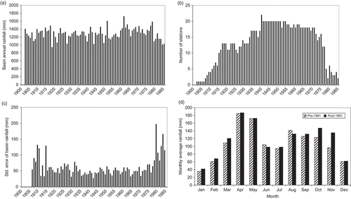
In addition, those stations whose records cover reasonable periods before and after 1961, have been examined to establish whether there is a significant change in the total rainfall or its seasonal distribution. The average seasonal distribution ((d)) reveals an increase which is concentrated in the October/November rainfall season; a similar increase was noted by Farmer (Citation1981) for East African rainfall. This increase is evident in almost all the stations near Lake Kyoga. To the northwest of the lake, where the two rainfall seasons tend towards coalescence, the increase is less evident.
LOCAL RAINFALL AND RUNOFF
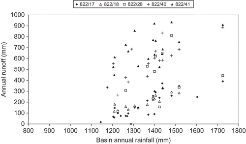
There are some measurements of runoff within the lake basin. During a study for the World Bank (Gibb Citation1989) monthly and annual flows were derived for a number of gauging stations, including five in the Kyoga basin. The average flows at these stations are summarised in . The annual runoff depths are compared to the Kyoga basin rainfall in In each case runoff is related to basin annual rainfall by a relation of the form Q = a(R – 1000), which implies that there is little runoff when the basin rainfall is below 1000 mm. A similar relation might apply to runoff from the whole basin. The runoff depth at some of the stations is very high, compared with the total inflow to Lake Kyoga, which is later estimated as 45 mm over the effective basin.
Fig. 7 Annual runoff from selected stations (see for WDD nos) and basin rainfall.
LAKE KYOGA WATER BALANCE
A comparison of the main channel inflow and outflow provides a preliminary estimate of the lake water balance. compares the annual inflows to the lake, based on the outflows from Lake Victoria at Jinja, with the outflows measured below the lake at Kamdini during the period 1940–1977, plus the change in lake storage estimated from water levels at Masindi Port and the lake area.
Fig. 8 Lake Kyoga: Kamdini outflow + lake storage change vs Jinja inflow, 1940–1977.
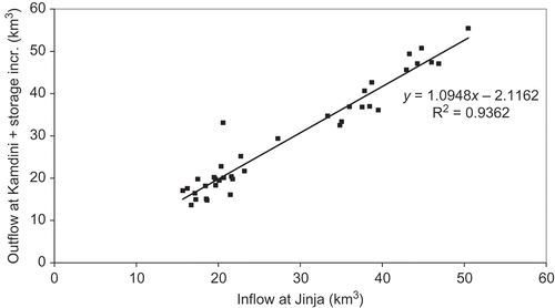
There have been numerous different estimates of the lake area, some of which seem to refer to the open water alone (it includes varying proportions of papyrus and open water, and has been invaded by water hyacinth in recent years). Maps based on satellite imagery (e.g. ILM Citation2004) show that the open water largely occurs in the western part of the lake and the northwest branch, with some isolated areas in the northeast branch. The fringes of the lake, and the southern and eastern branches, are filled with papyrus swamp, and there are further seasonal wetlands to the northeast. Analysis of these maps suggests that the total area of lake and papyrus swamp approximates to Hurst and Phillips’ (Citation1938) estimate of 6270 km2, but it is uncertain whether the distant branches form an integral part of the lake. Research in the Sudd (Sutcliffe and Parks Citation1996) reveals that papyrus cannot tolerate a range of water level exceeding about 1.5 m, but needs almost permanent wet conditions. This explains why it does not dominate the main body of the lake, but is confined to the distant branches; conversely it shows that these branches do not respond in full to rises at Masindi Port, but continue to transpire at the potential rate. WMO (Citation1982) provided a table linking lake area with elevation, but estimated the maximum area at 4700 km2. We have taken this area as a constant area, as the papyrus fringes of the main lake are likely to transpire at about the open water rate. This area has been used as a constant area to estimate changes in lake storage; in the annual inflows Q i are compared with the outflows Q o and the storage changes δS for the years 1940–1977. This graph confirms that the net outflow is greater than the inflow in years of high flow, and that the converse is true in years of low flow; the relation is described by the derived equation, in km3:
These gains can only derive from an increase in local runoff into the lake or higher net rainfall on the lake itself, so they should be related to rainfall on the Kyoga basin. The aim of the lake water balance is the estimation of the local contributions so that these overall gains and losses are explained. The individual contributions may be identified as: rainfall on the lake surface; evaporation from the lake, including open water evaporation and losses from the vegetation covering part of the lake; and the least known component, the inflow from the large basin draining to the lake. In the total increase in Nile flow, Q o + δS – Q i, is compared with basin rainfall R.
Fig. 9 Lake Kyoga: outflow–inflow + lake storage change vs basin rainfall, 1940–1977.
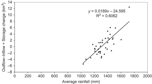
The relation is much less close than between inflow and outflow, but this is due to the problem of estimating the net gain from differences between two large and similar volumes, and by the inexact relation between basin rainfall and local runoff; nevertheless the relation is evident and may be expressed as:
The effect of the assumption of a fixed lake area was tested by substituting the changes in lake storage calculated using the WMO elevation–area curve, and both the equation and the correlation coefficient were virtually unchanged.
The net contribution may also be expressed as the local runoff q to the lake, the rainfall on the lake surface AR, minus the evaporation from the lake AE, both expressed in km3. As these two expressions are identical:
If realistic estimates can be substituted for the various physical factors in this expression, a reasonable relation may be derived between the local runoff series and the basin rainfall.
The rainfall is taken from the average of the 22 long-term stations in the area of the basin. In the case of Lake Victoria, it has been shown that the rainfall over the lake increases relative to the surrounding stations through physical causes relating to the size of the lake; in the case of Lake Kyoga this is less likely because of the shape of the surface. A constant figure of 4700 km2 for lake area has been used, but a sensitivity study showed that the rainfall and evaporation partly counteract each other. The lake evaporation is taken as 1750 mm/year, compared with 1595 mm used for Lake Victoria. Lake Kyoga is 100 m lower than Lake Victoria and shallow, and the adjoining stations of Soroti, Masindi and Lira have PE (crop evaporation) estimates of 1660, 1610 and 1750 mm (FAO Citation1993). The open water evaporation should be higher, and the evaporation from the floating vegetation and papyrus is assumed to be similar (Penman Citation1963), and constant from year to year. The annual volume of evaporation is estimated from this depth (1750 mm) and the area of the lake (4700 km2). The expression then reduces to:
This expression has a standard error of about 2.0 km3; this error is not surprising as the local inflow is derived from the difference between inflow and outflow volumes, which has been shown to have an error of about 1.3 km3, while the rainfall has an error of about 50 mm.
EquationEquation (5)(5) is relatively simple, but it would be difficult to calibrate a more complex model without long-term inflow records. When this expression is used to convert the basin rainfall series into annual flows, the average local inflow is estimated as 2.62 km3, with the highest inflow in 1961 estimated as 8.38 km3; this can be compared with the estimated “normal year” flow of 2.91 km3, based on two years of partial measurements (WMO Citation1974).
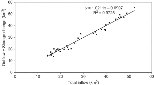
When these estimates are used to complete the comparison of total inflow, including Nile inflow, local inflow and net rainfall on the lake, with Nile outflow and change in lake storage (), the comparison is relatively good and significantly the relation:
Table 2 Lake Kyoga water balance, 1940–1977
Fig. 10 Lake Kyoga: outflow + lake storage change vs total inflow, 1940–1977.
EARLY FLOWS AT MASINDI PORT
The only long-term record between Lake Kyoga and Lake Albert includes the early flow measurements at Masindi Port, which have been considered inaccurate because they are supported by few gaugings. It could be useful to use the insight gained from comparing the later flows, to test the validity of the earlier flows. First the Jinja annual flows were compared with the Masindi Port flows for the years 1915–1939, plus the volume stored in Lake Kyoga, estimated from the annual gauge levels and an area of 4700 km2, in .
Fig. 11 Annual flows: Masindi Port + lake storage change and Jinja, 1915–1977.
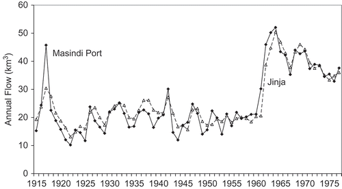
The large discrepancy in 1917, when there was a considerable inflow from the Lake Kyoga basin, is illustrated by the rise in levels at Lalli Port compared with Masindi Port. The historic flood of 1917 in South Sudan, known as Pilual (red water) by the Nuer people (Johnson Citation1992), gave rise to very high flows on the Pibor and Sobat, and must have been associated with heavy rainfall in the mountains near the Sudan–Uganda border; There were at this time no high rainfall records in the southern Kyoga basin, but there were no stations operating to the north in Karamoja.
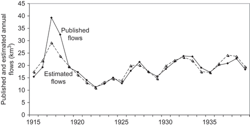
As a comparison, the Jinja flows have been adjusted by the model derived from the 1940–1977 records, with rainfall on the lake and evaporation based on an area of 4700 km2, and local runoff estimated from basin rainfall. The estimated flows are compared with the measured flows in Apart from the fact that the flood in 1917 was not predicted, the differences between the estimated and measured flows are closer than those based on Jinja flows alone, and the comparison suggests that the published flows at Masindi Port are a reasonable estimate of the true historic flows. This means that it is possible to use the early flows published in The Nile Basin to extend the knowledge of the flows available in the Kyoga Nile.
Fig. 12 Masindi Port: published and estimated annual flows, 1915–1939.
Acknowledgements
Most of the data used in this paper are available in The Nile Basin volumes and supplements: vol. II, Measured Discharges; vol. III, Ten-day and Monthly Mean Gauge Readings; vol. IV, Ten-day and Monthly Mean Discharges; vol. VI, Monthly and Annual Rainfall. Thanks are due to the Librarian, Centre for Ecology and Hydrology, Wallingford, for access to these volumes in the Hurst collection.
REFERENCES
- 1993 . CLIMWAT for CROPWAT: a climatic database for irrigation planning and management , Rome : Food and Agricultural Organization of the United Nations . FAO (Food and Agricultural Organization)
- Farmer , G. 1981 . Regionalisation and study of an alleged change in the rainfall climatology of East Africa , Thesis (PhD). University of Sheffield .
- Gibb , Sir Alexander and Partners . 1989 . Sub-Saharan Africa: hydrological assessment (IGADD Countries) Uganda Report to World Bank—UNDP in Association with British Geological Survey and Institute of Hydrology
- Gibb , Sir Alexander and Partners . 1996 . Uganda hydropower development masterplan: report on the hydrology of the Victoria Nile below Lake Victoria. Vol. 6 of Final Report to Uganda Electricity Board, by Kennedy and Donkin Power Ltd in Association with Sir Alexander Gibb and Partners
- Green , J. 2009 . “ The Kyoga catchment ” . In The Nile: origin, environments, limnology and human use Edited by: Dumont , H.J. InSpringer, 205--214
- Hurst , H.E. 1952 . The Nile , London : Constable .
- Hurst , H.E. and Black , R.P. 1943 . “ Monthly and annual rainfall totals and number of rainy days at stations in and near the Nile Basin ” . In The Nile Basin , Vol. VI , Cairo : Government Press . supplements
- Hurst , H.E. , Black , R.P. and Simaika , Y.M. 1946 . “ The future conservation of the Nile ” . In The Nile Basin , Vol. VII , Cairo : Government Press .
- Hurst , H.E. and Phillips , P. 1932 . Measured discharges of the Nile and its tributaries . The Nile Basin , II Cairo: Government Press.
- Hurst , H.E. and Phillips , P. 1938 . “ The hydrology of the Lake Plateau and Bahr el Jebel ” . In The Nile Basin , Vol. V , Cairo : Government Press .
- Hurst , H.E. and Phillips , P. 1939 . “ Ten-day mean and monthly mean discharges of the Nile and its tributaries ” . In The Nile Basin , Vol. IV , Cairo : Government Press . 2nd Supplement
- Hurst , H.E. , Simaika , Y.M. and Black , R.P. 1953 . The Nile Basin , Vol. IV , Cairo : Government Press . 4th supplement
- 2004 . Support to the management of Sudd blockage on Lake Kyoga. Produced for the Integrated Lake Management Project by Environmental Impact Assessment Centre of Finland, EIA Ltd ILM
- 1984 . A review of the hydrology of Lake Victoria and the Victoria Nile. Report to Sir Alexander Gibb and Partners , Wallingford : Institute of Hydrology . Institute of Hydrology
- 1993 . A review and update of the water balance of Lake Victoria in East Africa. Report to the Overseas Development Administration , Wallingford : Institute of Hydrology . Institute of Hydrology
- 1995 . HYDATA operation manual: version 3.21 , Wallingford : Institute of Hydrology . Institute of Hydrology
- Johnson , D.H. 1992 . Reconstructing a history of local floods in the Upper Nile Region of the Sudan . International Journal of African Historical Studies , 25 : 607 – 649 .
- Kigobe , M. 2011 . Multi-site stochastic modelling of daily rainfall in Uganda . Hydrological Sciences Journal , 56 ( 1 ) : 17 – 33 . et al
- Penman , H.L. 1963 . Vegetation and hydrology , Farnham Royal : Commonwealth Agricultural Bureaux .
- Rushdi , Said . 1993 . The River Nile: geology, hydrology and utilization , Oxford : Pergamon Press .
- Sutcliffe , J.V. 1996 . “ The role of local hydrological studies in water resources studies of the Nile basin ” . In 4th Nile 2002 conference, 1996, Kampala In
- Sutcliffe , J.V. and Parks , Y.P. 1996 . “ Hydrological controls of Sudd ecology ” . In Water management and wetlands in sub-Saharan Africa , Edited by: Acreman , M.C. and Hollis , G.E. 51 – 72 . Gland : IUCN . In
- Sutcliffe , J.V. and Parks , Y.P. 1999 . The hydrology of the Nile , Wallingford : IAHS Press, IAHS Special Publ. 5 .
- 1974 . Hydrometeorological survey of the catchments of Lake Victoria, Kyoga and Albert , Geneva : WMO/UNDP . WMO (World Meteorological Organization)
- 1982 . Hydrometeorological survey of the catchments of Lake Victoria, Kyoga and Mobutu Sese Seko: project findings and recommendations , Geneva : WMO/UNDP . WMO