Abstract
Groundwater development potential in northern Ghana (108 671 km2) has been assessed by combining spatial layers for five critical factors—recharge rate, regolith thickness, transmissivity, borehole success rate and static water level—through a multi-criteria analysis approach to rank development potential from the viewpoint of groundwater availability and accessibility at a resolution of 1 km2. The results indicate a high potential for development in the study area, as about 70% of the area was found to have high to moderate groundwater availability, while 83% has high to medium groundwater accessibility. Comparing the two main hydrogeological environments, the Precambrian Basement rocks (PCB) area was found to generally have a higher groundwater development potential than the Voltaian Sedimentary rocks (VSB). More detailed investigation revealed that the VSB can produce a small proportion of exceptionally high-yielding boreholes that can support large-scale irrigation. A test of the reliability of results showed that generally, the majority of high- and low-yielding boreholes fall in areas predicted by the model as having high and low groundwater availability, respectively.
Editor D. Koutsoyiannis; Associate editor D. Hughes
Citation Forkuor, G., Pavelic, P., Asare, E., and Obuobie, E., 2013. Modelling potential areas of groundwater development for agriculture in northern Ghana using GIS/RS. Hydrological Sciences Journal, 58 (2), 437–451.
Résumé
Le potentiel déexploitation des eaux souterraines au Ghana septentrional (108 671 km2) a été évalué en combinant les couches spatiales de cinq facteurs cruciaux – taux de recharge, épaisseur de régolithe, transmissivité, taux de réussite des forages et niveau statique – grâce à une approche déanalyse multicritère pour classer le potentiel déexploitation du point de vue de la disponibilité et l'accessibilité des eaux souterraines à une résolution de 1 km2. Les résultats indiquent un fort potentiel déexploitation dans la zone déétude: on a trouvé qu'environ 70% de la superficie a une disponibilité en eaux souterraines forte à modérée, tandis que 83% a une accessibilité en eau souterraine haute à moyenne. En comparant les deux environnements hydrogéologiques principaux, on a trouvé que la zone des roches du socle précambrien (RSP) avait généralement un potentiel déexploitation des eaux souterraines plus élevé que celle des roches sédimentaires du voltaien (RSV). Une étude plus détaillée a révélé qu'une petite proportion de forages des RSV pouvait avoir un rendement exceptionnellement élevé pouvant alimenter une irrigation à grande échelle. Un test de la fiabilité des résultats a montré que, généralement, la majorité des forages à haut et à faible rendements se trouvent bien dans les zones évaluées par le modèle comme ayant des disponibilités en eaux souterraines respectivement haute et basse.
INTRODUCTION
Agriculture is the backbone of the economies of many Sub-Saharan African (SSA) countries (Ngigi Citation2009). In Ghana, for instance, the sector employs about 60% of the nation's economically active population, and contributed about 38% of the foreign exchange earnings in 2008 (ISSER Citation2008). Like many other SSA countries, farming in Ghana is heavily reliant on rainfed agriculture, but continuous reliance on rain water can be risky and restricts the improvement of food security over the longer term. Van de Giesen et al. (Citation2001) noted that rainfall is becoming an unreliable resource for agriculture in the Volta Basin of West Africa due to high spatial and temporal variability. West Africa has been noted to have more severe droughts compared to Central Africa (Mahé et al. Citation2001). L'Hôte et al. (Citation2002) also showed that, since the 1970s, there has been an abrupt decline in annual rainfall in West Africa Sahel, noting that it was uncertain as to whether or not rainfall had recovered in recent years. More recently, Laux et al. (Citation2008) have identified high uncertainties in the onset of the rainy season. Climate change/variability may aggravate this situation (Jung and Kunstmann Citation2007). In order to minimize these effects and enhance food security, additional sources of water for crop cultivation must be considered. Adoption of small-scale groundwater interventions for crop cultivation can greatly boost agricultural production and food security in SSA (Taylor et al. Citation2009). Unlike rainfall and surface water, groundwater is better buffered against droughts and climate change/variability (Carter and Parker Citation2009, MacDonald et al. Citation2009).
Despite its numerous advantages, groundwater is largely underdeveloped in SSA, and its use for agricultural purposes lags greatly behind other regions of the world such as China and India (Shah et al. Citation2007). However, according to FAO estimates, internally renewable groundwater supplies in SSA are around 1500 km3 per year (FAO Citation2003). This compares favourably with figures for China and India, two countries whose agricultural economies have been completely transformed by groundwater usage (Shah et al. Citation2003). In fact, the comparison shows that SSA has about three and six times the per capita groundwater availability of China and India, respectively (Giordano Citation2006). Despite this, groundwater use for agriculture on the continent is minimal (Giordano Citation2006), although isolated cases of high agricultural usage exist (IUCN Citation2004). Giordano (Citation2006) noted that across SSA, 1 to 2 million hectares of cropped land is irrigated with groundwater, which contributes to the livelihoods of only 1.5–3% of the rural population. In a study conducted in Ghana, van den Berg (Citation2008) found that only 4% of groundwater in the Atankwidi catchment is used for irrigation, compared to 29% for domestic, 39% for livestock and 28% for construction uses.
The poor development of groundwater in SSA and its subsequent low use in agriculture can be attributed to several factors. These include: (a) large variations in geology and climate (MacDonald and Davies Citation2000); (b) high cost of development and risk of well failures (Kandiah Citation1997); and, more importantly, (c) complexity and lack of understanding of the hydrogeological environment of the continent (Tuinhof et al. Citation2011). So far, little knowledge has been built on groundwater potential and use across SSA through the continuous collection, verification, registration and archival of hydrogeological data from drilled boreholes (Tuinhof et al. Citation2011). Groundwater development has mainly been demand-driven, with little investigation of an area's potential for development of the resource, leading to high failure rates and a lack of confidence from potential developers (Dapaah-Siakwan and Gyau-Boakye Citation2000).
In order to achieve sustainable groundwater production and reduce investment losses through failures in well drilling, there is a clear need to base development on knowledge of the suitability of targeted areas for groundwater development. Various attempts have been made in the past to identify and map potential areas for groundwater development at varying scales. These include a global assessment at 1:25000000 scale (WHYMAP Citation2008), a regional assessment at 1:40000000 scale (MacDonald and Davies Citation2000), country-level analyses—Ethiopia, Ghana and South Africa (MacDonald et al. Citation2001, Woodford et al. Citation2006, Gumma and Pavelic Citation2012) and a basin-level (Volta) assessment (Martin and van de Giesen Citation2005). Although these studies are useful, and have provided general overviews of the groundwater situation at various scales, there are still factors that limit their use. For example, the coarseness of scale (e.g. 1:40 000 000) makes it almost unusable at sub-national level. In addition, often the studies lack a systematic accuracy assessment that tests their validity, while others considered too few factors, e.g. only rainfall and geology in the case of MacDonald et al. (Citation2001).
To augment the efforts of the above studies, the present study reports a broad-scale (108 671 km2) analysis conducted in the northern half of Ghana. Data for this study are drawn from a comprehensive database of about 10 000 borehole records developed as part of the Hydrogeological Assessment Project (HAP) undertaken by the Water Resource Commission (WRC) of Ghana in partnership with SNC-Lavalin-INRS of Canada, with financial assistance from the Canadian International Development Agency (CIDA). This study combines spatial layers of recharge rate, regolith thickness, static water level, transmissivity and borehole success rate in a multi-criteria analysis to identify potential areas for groundwater development in northern Ghana. The analysis aims to identify potential areas for all types of groundwater use. However, in terms of the application potential, the focus here is to identify areas where groundwater can support small-scale irrigation technologies that are relatively inexpensive for the poor farmers in northern Ghana.
STUDY AREA
The study was conducted in the three northern regions of Ghana—Upper East (UE), Upper West (UW) and Northern (N) (). The availability of the HAP data set was a key determinant in selecting these regions. The main source of water for inhabitants of these regions is groundwater (GSS Citation2002). According to Gyau-Boakye and Dapaah-Siakwan (Citation1999), the groundwater dependency for domestic use is 28.4%, 74.5% and 76.8% for N, UW and UE, respectively. Poverty is widespread in the regions, with the UW being the poorest (GSS 2002). Agriculture employs on average 70% of the economically active people. The area has a uni-modal rainfall distribution, with annual rainfall ranging between 800 and 1000 mm. The area is fairly flat, with average slope of less than 1%. Rates of population growth are mixed; region N recorded a growth rate of more than the national average (2.4%) in the 2010 census, while that of UE is significantly lower (1.1%).
Fig. 1 Map of the study area showing the main geological formations.
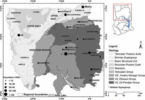
Groundwater in the study area occurs in two main hydrogeologic environments—basement rocks (54%) and consolidated sedimentary rocks (45%) (Dapaah-Siakwan and Gyau-Boakye Citation2000). Predominant compositions of the basement rocks include gneiss, phyllite, schist, migmatite, granite-gneiss and quartzite. Groundwater availability in aquifers of this environment is highly variable due to the varying intensity of weathering processes involved in regolith development (HAP Citation2009). Groundwater storage capacity is, thus, influenced by the degree of weathering (Larsson Citation1984). Field and Collier (Citation1998) found that the groundwater storage capacity of the basement rocks is generally poor, with yields typically less than 1 L s−1. Consolidated sedimentary rocks, locally known as the Voltaian, are naturally impermeable, though at local scales, higher permeability may be present due to fracturing, faulting and weathering (HAP 2009). The Voltaian is generally regarded as having a poor groundwater potential due to the predominance of mudstones (65%), although Walling (Citation1996) states that sufficient groundwater yields could be obtained if siting is based upon adequate geophysical investigations. Other constituents of this formation are sandstones, shale, arkose, sandy and pebbly beds and limestone. The regolith in this environment is generally thin (Bannerman Citation1990) and unable to store much water. Groundwater thus occurs and flows in deeper fractured zones where the main aquifer is normally located. As a result, groundwater is encountered at generally deeper levels that fall near or beneath the regolith (HAP 2009). These factors are believed to be partly responsible for the high borehole failure rate associated with this formation.
DATA AND METHODOLOGY
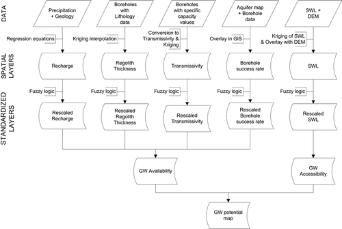
Five major hydrogeological factors were considered in the development of groundwater potential maps. These are: recharge rate, transmissivity, regolith thickness, borehole success rate and static water level. GIS raster layers for each of the factors were created from different data sources. Due to the disparate scales of the factors, they were standardized into comparable units prior to combining them. Fuzzy set theory (Malczewski Citation1999) was used for the standardization of the factors. presents a summary of the processes followed. The sections below detail the relevance of each factor to groundwater development and how each layer was created.
Fig. 2 Flowchart of processes used to create the groundwater potential map.
RECHARGE RATE
Estimation of recharge rate is essential for determining groundwater availability and the proper management of aquifers (MacDonald et al. Citation2001, Adomako et al. Citation2010). Factors that control recharge rate include geology, rainfall (intensity and distribution), land use, and soil type. Recharge studies have previously been conducted in West Africa that quantify it as a percentage of annual rainfall using the water table fluctuation method (Sandwidi Citation2007, Obuobie Citation2008).
In this study, the development of a recharge layer followed the approach of Martin and van de Giessen (Citation2005). They compiled a variety of West African studies that estimated recharge rates from rainfall for two main lithologies: weathered rocks and sandstones. Using linear regression analysis, equations representing the relationship between annual rainfall and recharge rates were developed: Equationequations (1)(1) and (2) below. These relationships were adopted in this study.
– for sandstones
– for weathered rock
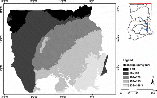
First, the geology of Ghana was reclassified into the two main classes mentioned above. The Voltaian super group was generalized as “sandstones”, while the Precambrian rocks were generalized as “weathered rocks”. Mean annual rainfall for the study area was obtained from WorldClim (http://www.worldclim.org/) based on 1-km resolution gridded data. This data set was preferred over other freely available data sets because it represents a long-term mean annual rainfall (1950 and 2000). Considering the high temporal and spatial variability of rainfall in the study area, a long-term mean annual rainfall is preferred to rainfall over a shorter period. Based on Equationequations (1)(1) and (2) above, a recharge map was created ().
Fig. 3 Annual average recharge map of the study area.
AQUIFER TRANSMISSIVITY
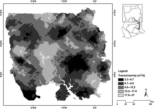
Transmissivity is typically derived from aquifer pumping tests; however, in this study, it was estimated from specific capacity (SC) (Darko and Krasny Citation2007) due to the availability of SC data in the HAP database. Mace (Citation2001) noted that the reliability of regionalized transmissivity estimation using SC values can improve by an order of magnitude due to the relative abundance of SC data compared to limited pump test data. Empirical equations ((3) and (4) below) were used to convert SC values to transmissivity, before the points were kriged using the Geostatistical Analyst extension of ArcGIS®.
Kriging was chosen due to some key advantages it has over other interpolation methods, such as spline and inverse distance weighting. These include: (a) consideration of the stochastic aspects of spatial variation in assigning weights (Burrough and McDonnell Citation1998); (b) quantification of estimation variance, thus, giving an idea of the precision of estimates (Fatima-Zhora Citation2006); and (c) compensating for the effects of data cluster, i.e. treating clusters like single points. The data set was first explored to check for normality and trends (de Smith et al. Citation2009). A log transformation was applied to ensure normality. Different models and parameters (range, sill, nugget) were experimented with, while studying the error estimates (e.g. root mean square error) produced after cross-validation. This analysis was performed for all data sets that were kriged. The spherical model was found to be the most suitable. Cross-validation results indicated that the model performed reasonably well, with mean error close to zero (–0.059) and root mean square standardized error close to one (0.9065).
Transmissivity in the study area () was found to range between 3.3 and 27 m2 d−1 with an arithmetic mean of 10 m2 d−1. These figures fall within the range quoted by other studies, e.g. Darko and Krasny (Citation2007).
Fig. 4 Spatial distribution of transmissivity in northern Ghana.
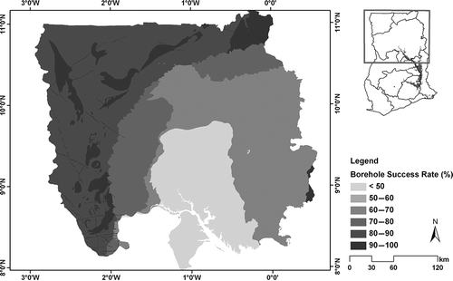
BOREHOLE SUCCESS RATE
A layer of borehole success rate was created based on a geological map and information on borehole successes and failures. The rationale behind the creation of this layer is that areas that have witnessed more failures may be less viable to explore. Although many factors may cause borehole failure, the underlying rock type is a key factor that determines the degree of aquifer heterogeneity.
According to WRC, a borehole is said to be successful (for domestic purposes) if it has a yield of at least 10 L min−1 (CWSA Standards and Guidelines Citation2010). Due to the fact that not all the borehole records in the HAP database had information on yield, the success or otherwise of a borehole was inferred from the “wellstate” attribute field in the database. Unique values in this field are: functional, dry, rehabilitated, defective and condemned. Boreholes labelled dry are those that could not meet the 10 L min−1 threshold, while defective ones meet the 10 L min−1 threshold but have water quality issues (e.g. high fluoride concentration). Condemned ones are those that initially met the 10 L min−1 threshold but dried out shortly thereafter and thus were condemned. Rehabilitated boreholes are those that had a mechanical problem (e.g. pump) that has since been solved. Based on these considerations, boreholes labelled as functional, defective and rehabilitated were classified as “successful” for this purpose, while dry and condemned ones were classified as “failure”. A total of 8447 boreholes were considered.
In creating the layer, the reclassified boreholes were overlaid with a geology map in a GIS environment. The percentage of successful boreholes in each geological unit was subsequently calculated. presents these results.
Fig. 5 Layer of borehole success rate.
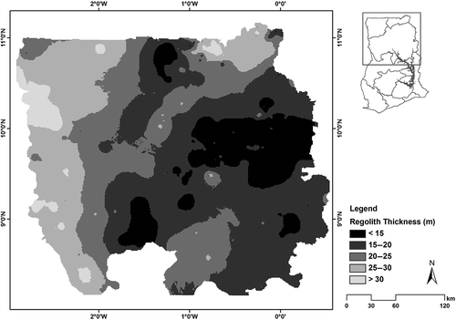
REGOLITH THICKNESS
Eggleton (Citation2001) defined the regolith as “the entire unconsolidated or secondarily re-cemented cover that overlies more coherent bedrock that has been formed by weathering, erosion, transport and/or deposition of the older material”. Regolith in the study area is comprised of in situ physico-chemically weathered material as well as transported surface material. Knowledge of the thickness of the regolith is important in determining the extent as well as the accessibility of groundwater resources. It is a good indicator of an aquifer's storativity and, as such, a thicker regolith may suggest higher storage.
Analysis of the lithological data of the HAP database revealed that 790 boreholes completely penetrated the regolith and hence provided data on the total thickness of the regolith. These points (boreholes) were spatially interpolated to derive a spatial layer of regolith thickness. Again the kriging interpolation tool in the Geostatistical Analyst extension of ArcGIS was used. As explained above, preliminary exploration of the data was performed to check normality and to select the best variogram model and parameters. The spherical model was used. Cross-validation results obtained indicated a mean error close to zero (0.00226) and root mean square standardized error close to one (0.923). shows this layer.
Fig. 6 Spatial distribution of regolith thickness across the study area.
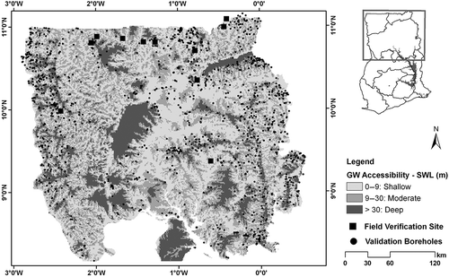
STATIC WATER LEVEL
Static water level (SWL) represents the depth below the ground surface of the ambient (non-pumped) groundwater level in a well. Although it is subject to changes, and may fluctuate within a range from season to season due to variations in recharge rate and pumpage, information on SWL offers a direct indicator of groundwater accessibility. Information on SWL was available for 878 boreholes. In creating this layer, the static water elevation (SWE) at each borehole location was first determined by subtracting the SWL from the corresponding ground elevation (i.e. above mean sea level) which was derived from the Shuttle Radar Topographic Mission (SRTM) Digital Elevation Model (DEM). SWE values were then spatially interpolated using the kriging method as explained above. Cross-validation results indicated a mean error close to zero (0.01003) and root mean square standardized error close to one (1.068). The interpolated SWE represents the potentiometric surface. The final SWL map was derived by subtracting the SWE surface (potentiometric surface) from the SRTM DEM of the study area.
This layer was reclassified into a groundwater accessibility map. The rationale behind this is that groundwater can be easily accessed (in terms of drilling technology and cost) in areas with low SWL values. shows the reclassified map.
Fig. 7 Spatial layer of static water level.
STANDARDIZATION OF FACTORS
Due to their disparate scales (e.g. recharge in mm, transmissivity in m2 d−1, etc.), the factors were rescaled. The purpose of this step is to make any combination meaningful. Fuzzy set theory (Malczewski Citation1999) was employed in standardizing the factors. Unlike the conventional crisp (Boolean) sets that allow only binary membership functions (i.e. true or false—membership or no membership), fuzzy sets admit the possibility of a partial membership (Burrough and McDonnell Citation1998). In other words, fuzzy sets have no sharp boundaries; rather, the transition between membership (“1”) and non-membership (“0”) of a location in the set is gradual (Schmucker Citation1982). Thus, a fuzzy set is characterized by a fuzzy membership grade that ranges from 0 to 1, indicating a continuous increase from non-membership (0) to complete membership (1).
In this study, the user-defined fuzzy function proposed by Eastman (Citation2006) was used to standardize all spatial layers into commensurate scales. A pre-requisite for the use of this function is the determination of points of inflection that indicate points of change in the fuzzy membership curve. Thus, these points define the shape of the fuzzy set membership curve. For each factor (spatial layer), the points of inflection were selected based on a cumulative histogram plot of the factor. The membership values between any two points of inflection are determined by linear interpolation. Using this function, all spatial layers were rescaled to range between 0 and 1, indicating a continuous increase from non-membership (0) to complete membership (1).
Table 1 Groundwater availability and accessibility combination matrix
The weighted linear combination (WLC) method (Malczewski Citation2000) was used to combine the standardized factors. This method combines factors by applying a weight to each, and then summing the results to yield a final map (Eastman Citation2006), Equationequation (5)(5). In this study, all four factors were considered equally important, thus a weight of one was given to each.
RESULTS
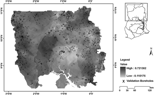
A groundwater availability map was first developed by combining the standardized spatial layers of recharge rate, transmissivity, regolith thickness and borehole success rate (). This map has the same range as those for the individual factors since values of each factor were normalized between 0 and 1. The map indicates that areas with a value of 0.1 have the least groundwater availability, while areas with a value of 0.7 have the highest. Prior to combining with the accessibility layer, the availability map was reclassified into three classes: high (0.6–0.72), medium (0.5–0.6) and low (0.12–0.5). A study of the layer's histogram aided in choosing the class breaks specified. Reclassified maps of groundwater availability () and accessibility according to SWL () were combined, using the matrix presented in , to produce a composite map showing groundwater development potential zones in northern Ghana. shows the final result while presents statistics extracted for the two main hydrogeological provinces.
Table 2 Area under various groundwater development potential classes
Fig. 9 Groundwater development potential map of northern Ghana.
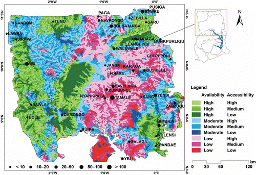
Fig. 8 Map of groundwater availability in northern Ghana.
The statistics presented in reveal that the Precambrian (PCB) generally has a higher groundwater potential than the Voltaian (VSB). About 45% of the area covered by the PCB has high groundwater availability, 42% moderate and 13% has low groundwater availability. The VSB has 25% of its area having high groundwater availability, 31% moderate and 44% low groundwater availability. Groundwater accessibility of both formations is reasonably good, with the PCB being slightly better than the VSB. About 86% of the area covered by the PCB has a high to medium accessibility, while that of the VSB is 81%. For the VSB, the Dapango-Bombouaka group was found to have the highest groundwater potential, followed by the Oti-Pendjari, with the Obosom group having the least groundwater potential. For the PCB, the Capecoast-Granitoids have the highest groundwater potential, followed by the Birimian supergroup, with the Tarkwain having the least potential. Apart from recharge, which is generally higher for the VSB, all other factors favour the PCB. In other words, the PCB has a thicker regolith, has a superior borehole success rate and slightly higher transmissivity than the VSB.
Validation of results
The reliability of the results obtained was tested against measured data. The two maps—groundwater availability and accessibility—were validated separately, due to the difficulty in identifying a single data set that could validate the composite map. Data on borehole yields were used to validate the groundwater availability map, while the groundwater accessibility map was validated partly with borehole depths and field observations.
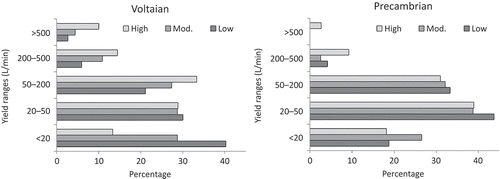
Groundwater availability In this study, factors were selected partly based on data availability and partly on their relevance to groundwater and replenishment. To test the reliability of this map, comparisons with borehole yields were made. Previous studies have indicated a positive correlation between borehole yield and groundwater availability (Mohammed-Aslam et al. Citation2010). Thus, high-yielding boreholes are likely to be found on high groundwater availability areas. A total of 1308 functional boreholes that have both yield and depth information were used. For each groundwater availability category—high, moderate, low—the percentage of boreholes falling in different yield ranges for the two main hydrogeological provinces were determined. It is generally expected that the majority of low-yielding boreholes will fall on “low availability” areas and similarly, high-yielding ones will occur on “high availability” areas. shows that the model better conforms to the measured data on the VSB than on the PCB. For the VSB, the percentage of low-yielding boreholes (<20 L min−1) is highest (40%) on the “low availability” areas compared to 13% of such boreholes that fall on “high availability” areas. On the other end, the percentage of exceptionally high-yielding boreholes (>500 L min−1) is highest (10%) on the “high availability” areas compared to a corresponding 2.6% on “low availability” areas. For the PCB, the only exceptionally high-yielding boreholes (2.6%) are found on the “high availability” areas, while the “low” and “moderate availability” areas have no such boreholes. There is, however, an anomaly concerning the location of low-yielding boreholes (i.e. <20 L min−1). The percentage of boreholes with yields <20 L min−1 is highest (26%) on the “moderate availability” areas rather than on “low availability”, although the percentage of those with yields between 20 and 50 L min−1 is highest on “low availability” areas. This could mean that both “low” and “moderate availability” areas are characteristic of low-yielding boreholes. Considering the high variability of aquifer systems in this environment, due to the varying intensity of weathering processes involved in regolith development (HAP 2009), such anomalies may happen, especially when modelling at a regional scale. Although the factors considered in generating the groundwater availability map may not be exhaustive, and inclusion of other factors may improve the validation results, on the whole it appears that the groundwater availability map is a reasonable representation of the situation in northern Ghana.
Table 3 Comparison between field- and model-classified groundwater accessibility
Fig. 10 Percentage of boreholes falling in different yield categories.
Groundwater accessibility SWL was used as a surrogate for groundwater accessibility. Results from a field survey were used to partly validate the reliability of the groundwater accessibility map. Eleven sites were visited (see ), and based on observations each site was classified as having a high, medium or low accessibility. Key questions asked, and observations made, included: (a) average depth of shallow wells, (b) level of water in wells, (c) proximity of wells to streams/rivers, and (d) how often wells dry up. Well depths ranged between 0.9 and 8 m. A key determinant of the classification given was the level of water in the wells. For example, areas that have wells with water level as high as within 0.9 m below ground level were considered as highly accessible, given that most wells in the study area dry up during the dry season. compares the between-field and model classifications. For nine of the 11 sites, the classification given in the field matched the model classification, while for two sites they differed.
Additionally, the reliability of the layer was tested using depth information of 1308 boreholes. Areas of high SWL are likely to have boreholes with shallower depths than those with low SWL. For each groundwater accessibility category—high (shallow), medium, and low (deep)—the percentage of boreholes that fall in different depth ranges is presented in . It is expected that the majority of boreholes that fall in the “low accessibility” category will generally have higher depths, while those in “high accessibility” areas will have lower depths. “High accessibility” areas had the lowest percentage (27%) of boreholes falling in the high depth (>50 m) category and the highest percentage (0.7%) of boreholes falling in the low depth (<20 m) category. This is expected, and a confirmation that the area has high groundwater accessibility. However, none of the boreholes on the low accessibility areas fell in the <20 m depth range, a partial confirmation of the area's low groundwater accessibility. The remaining percentages for the medium and low accessibility areas do not clearly follow the expected, especially as the percentage of boreholes having a depth of >50 m for both categories is almost the same (31%). Despite these anomalies, the layer is still thought to be a fair representation of groundwater accessibility in northern Ghana, given the heterogeneity of aquifer systems in the study area (HAP 2009). In practice, accessibility could vary greatly within a short distance, which is a confounding factor for the model that is based on a 1-km resolution.
Table 4 Percentage of boreholes falling in different depth ranges
DISCUSSION
The results obtained in this study are largely consistent with previous studies. MacDonald and Davies (Citation2000), in reviewing groundwater for rural domestic supply in SSA, identified the PCB as the most important source of groundwater, covering 40% of SSA and supporting about 220 000 000 rural inhabitants. They noted that the existence of a thick weathered zone (regolith) is critical to the occurrence of groundwater. Martin and van de Giessen (Citation2005) modified the approach developed by the Inter-African Committee for Hydraulic Studies (ICHS Citation1986) and applied it to the Volta basin. They identified the Voltaian Obosum group as having the least groundwater development potential mainly due to unfavourable lithology (predominantly shale, siltstone and consolidated sandstones). More recently, Gumma and Pavelic (Citation2012) also identified the PCB as having a high groundwater potential compared to the VSB.
The poor groundwater potential of the VSB can be attributed to a number of factors:
| a. | Aplin et al. (Citation1999) noted that 65% of all sedimentary aquifers are mudstones, which are generally poor aquifers, leading to high borehole failure rates. | ||||
| b. | Due to the thinness of the regolith in the VSB, aquifers are normally located in deeper fractured zones. This results in deeper water levels, falling near or below the base of the regolith (HAP 2009). Considering the average depth of boreholes drilled in Ghana (40 m), it is not surprising that many failures have been recorded on the VSB. | ||||
| c. | Another reason for the high drilling failures on the VSB is lack of adequate investigation. Dapaah-Siakwan and Gyau-Boakye (Citation2000) explained that a sizeable proportion of boreholes drilled in northern Ghana prior to the 1980s were done without a proper geophysical investigation to determine the best areas to be drilled. Thus, a high failure rate may indicate a lack of understanding of the complexities of the aquifer systems. For example, MacDonald and Davies (Citation2000) stressed the need to use ground conductivity and resistivity methods to distinguish sandstone from mudstone on consolidated sedimentary formations. | ||||
Despite the above points, this study has shown that the VSB can produce some exceptionally high-yielding boreholes. Analysis of the over 1300 validation boreholes revealed that the percentage of high-yielding boreholes is greater on the VSB than on the PCB. indicates that, whereas the percentage of low-yielding boreholes is about the same for both formations, there are twice as many high-yielding boreholes (>200 L min−1) for the VSB than the PCB. This means that when proper investigations are done prior to drilling on the VSB, good results can be obtained. A possible explanation of the exceptionally high yields obtained on the VSB is the thickness of the regolith vis-a-vis recharge. The VSB generally has a thin regolith which develops over sandstone and siltstone. This is believed to facilitate recharge to the underlying fractured aquifer which normally falls near or below the regolith (HAP 2009), leading to high storage volumes. Thus, despite having a low groundwater development potential, a few carefully constructed boreholes on the VSB may prove more useful than a larger number of low-yielding boreholes on the PCB.
Table 5 Comparison of borehole yields on the two main hydrogeological environments
Implications for agriculture
Recent studies have highlighted the economic benefits farmers derive as a result of the usage of shallow groundwater for dry-season cultivation (Mdemu et al. Citation2010). Thus, the development of groundwater for agriculture, especially in the dry season, is crucial. However, knowledge of where to explore/develop has often hindered this at various levels. For instance, at the small-scale farmer level, van den Berg (Citation2008) described farmers' use of trial-and-error methods in locating shallow wells in the Atankwidi catchment of the Upper East region. At the institutional level, some organizations that would like to invest in small-scale, low-cost irrigation technologies struggle to identify the best areas to develop the resource. For example, efforts by non-government organizations to drill production wells using manual methods in northern Ghana failed to obtain the desired results. This can partly be attributed to lack of information on potential areas for groundwater development in the country.
The outputs derived from this work are an important first step in developing a knowledge base for future exploration. Calow et al. (Citation1997), Robins et al. (Citation1997) and Calow et al. (Citation2000), in separate studies in some SSA countries, noted that groundwater availability and accessibility are essential indicators of water security during drought periods in SSA. Thus, the reclassification of results into availability and accessibility is essential, and will assist developers in selecting areas that need urgent attention with regard to groundwater development (i.e. areas of high water insecurity during drought). It will also help donors/ development partners to select areas based on what they intend to achieve. For example, most farmers in northern Ghana cultivate relatively small areas (in the dry season), and thus do not have the economic power to develop large-scale groundwater systems. In such a case, areas of high groundwater accessibility and availability may be the areas to focus on, whereas commercial farms, with enough capital to go deeper, may want to explore areas with high availability, but low accessibility. Evidence exists that, for the VSB, for instance, deeper wells (especially in sandstones) normally yield enough water for urban supply, industrial uses and agricultural irrigation (MacDonald and Davies Citation2000).
CONCLUSIONS
In this study, potential groundwater development hotspots in northern Ghana have been mapped by combining spatial layers of five factors deemed to be critical to the occurrence, movement and replenishment of the resource. Groundwater availability and accessibility maps were created and later combined to produce the groundwater potential map. The reliability of results obtained was tested against borehole yield and depth data. It showed that, in general, the majority of low-yielding boreholes fall in areas modelled as having low groundwater availability and vice versa. Comparison of modelled groundwater accessibility categories with field observations revealed an 82% match between the two.
The results indicate that, of the two main hydrogeological environments in northern Ghana, the PCB generally has a higher groundwater development potential than the VSB. Of the PCB area, 45% has high groundwater availability as against 25% on the VSB. Low groundwater availability areas comprise 13% and 44% of the PCB and VSB, respectively. Groundwater accessibility is slightly better on the PCB, with 86% of its area having a high to medium accessibility, compared to 81% for the VSB. Despite the VSB's generally poor potential, careful investigation using ground conductivity and resistivity methods prior to drilling can result in exceptionally high-yielding boreholes which may be useful for large-scale agricultural irrigation. Yield analysis of over 1300 boreholes revealed that there are twice as many high-yielding boreholes (>200 L min−1) on the VSB than the PCB.
The map presented in this study is expected to guide government, donors and development partners in identifying priority areas for groundwater development. This will help reduce investment losses through well failures. It must be stated, however, that the map (at 1-km resolution) presents a regional overview, due to the heterogeneity of aquifer systems in the study area. Further analysis is, therefore, required in order to apply this to local scales.
Acknowledgements
This study was financially supported by the Rockefeller Foundation through project number 2008-AGR-305 “Groundwater in sub-Saharan Africa: Implications for food security and livelihoods” under the CGIAR Research Programme on Climate Change, Agriculture and Food Security (CCAFS). The authors would like to sincerely thank the management of the Hydrogeological Assessment Project (HAP) and the Water Resources Commission for providing the necessary borehole information. Invaluable comments and feedback from Dr Benony Kortatsi of the Water Research Institute and Dr Thomas Armah of the Geology Department at the University of Ghana are greatly appreciated. The authors are also grateful to the anonymous reviewers whose suggestions greatly improved the paper.
References
- Adomako , D. 2010 . Estimating groundwater recharge from water isotope (δ2H, δ18O) depth profiles in the Densu River basin, Ghana . Hydrological Sciences Journal , 55 ( 8 ) : 1405 – 1416 .
- Aplin , A.C. , Fleet , A.J. and MacQuaker , J.H.S. 1999 . “ Muds and mudstones: physical and fluid flow properties ” . In Muds and mudstones: physical and fluid flow properties , Edited by: Aplin , A.C. , Fleet , A.J. and MacQuaker , J.H.S. Vol. 158 , 1 – 8 . London: Geological Society, Special Publication . In:
- Bannerman , R.R. 1990 . Appraisal of hydrogeological conditions and analysis of boreholes in the Nanumba and Western Gonja districts—Northern Region. Accra , Programme for Rural Action NORRIP/GTZ, Unpublished Report, April 1990 .
- Burrough , P.A. and McDonnell , R.A. 1998 . Principles of geographic information systems , New York : Oxford University Press .
- Calow , R.C. , MacDonald , A.M. and Nicol , A.L. 2000 . Planning for groundwater drought in Africa: towards a systematic approach for assessing water security in Ethiopia . British Geological Survey Technical Report WC/00/13 ,
- Calow , R.C. 1997 . Groundwater management in drought prone areas of Africa . International Journal of Water Resources Development , 13 ( 2 ) : 241 – 261 .
- Carter , R.C. and Parker , A. 2009 . Climate change, population trends and groundwater in Africa . Hydrological Sciences Journal , 54 ( 4 ) : 676 – 689 .
- CWSA (Community Water and Sanitation Agency) . 2010 . Community Water and Sanitation Agency Standards and Guidelines, 2010 edition (unpublished)
- Dapaah-Siakwan , S. and Gyau-Boakye , P. 2000 . Hydrogeologic framework and borehole yields in Ghana . Hydrogeology Journal , 8 ( 4 ) : 405 – 416 .
- Darko , P.K. and Krasny , J. 2007 . “ Regional transmissivity distribution and groundwater potential in hard rock of Ghana ” . In Groundwater in fractured rocks , Edited by: Krasny , J. and Sharp , J. 109 – 119 . London : Taylor and Francis . In:
- de Smith , M.J. , Goodchild , M.F. and Longley , P.A. 2009 . Geospatial analysis: a comprehensive guide to principles, techniques and software tools , Leicester , , UK : Matador .
- Eastman , R.J. 2006 . IDRISI Andes: guide to GIS and image processing , Worcester (MA) : Clark University .
- Eggleton , R.A. 2001 . The regolith glossary , Perth : CRC LEME .
- FAO (Food and Agriculture Organization) . 2003 . Review of world water resources by country , Rome : Food and Agriculture Organization of the United Nations, Water Report 23 .
- Fatima-Zohra , B.L. 2006 . Estimating soil contamination with kriging interpolation method . American Journal of Sciences , 3 ( 6 ) : 1894 – 1898 .
- Field , W.P. and Collier , F.W. 1998 . Checklist to assist preparation of small-scale irrigation projects in sub-Saharan Africa , New Delhi, India : Institute of Hydrology Report to ICID .
- GSS (Ghana Statistical Service) . 2002 . Population and housing census: summary report on final results , Accra : Ghana Statistical Service .
- Giordano , M. 2006 . Agricultural groundwater use and rural livelihoods in Sub-Saharan Africa: a first-cut assessment . Hydrogeology Journal , 14 : 310 – 318 .
- Gumma , M.K. and Pavelic , P. 2012 . Mapping of groundwater potential zones across Ghana using remote sensing, geographic information systems, and spatial modelling . Environmental Monitoring Assessment , doi: 10.1007/s10661-012-2810-y
- Gyau-Boakye, P. and Dapaah-Siakwan, S., 1999. Groundwater: Solution to Ghana's rural water supply industry. Journal of the Ghana Institution of Engineers. http://africantechnologyforum.com/GhIE/ruralwtr/ruralwtr.htm (http://africantechnologyforum.com/GhIE/ruralwtr/ruralwtr.htm) (Accessed: 10 May 2011 ).
- HAP (Hydrogeological Assessment Project) . 2009 . Hydrogeological assessment of the northern regions of Ghana , Accra : Water Resources Commission, Interim Report, January 2006–June 2008 .
- ICHS (Inter-African Committee for Hydraulic Studies) . 1986 . Explanatory notice and recommended usage of the map of potential groundwater resources in Western and Central Africa 1:5,000,000 , Orléans , , France : ICHS, BRGM .
- ISSER (Institute of Statistical, Social and Economic Research) . 2008 . The state of the Ghanaian economy in 2008 , Accra : ISSER .
- IUCN . 2004 . Institutional arrangements for groundwater management in Dolomitic terrains—water demand assessment , Pretoria , South Africa : Water Research Commission WRC Project 1324 .
- Jung , G. and Kunstmann , H. 2007 . High-resolution regional climate modelling for the Volta Basin of West Africa . Journal of Geophysical Research , 112 : D23108
- Kandiah , A. 1997 . “ Summary of findings of missions in selected countries in east and southern Africa ” . In Irrigation technology transfer in support of food security , Rome : Food and Agriculture Organization of the United Nations, Water Reports 14 . In:
- Larsson , I. 1984 . Ground water in hard rocks , Paris : UNESCO, Project 8.6 of the Hydrological Programme .
- Laux , P. , Kunstmann , H. and Bardossy , A. 2008 . Predicting the regional onset of the rainy season in West Africa . International Journal of Climatology , 28 ( 3 ) : 329 – 342 .
- L'Hôte , Y. 2002 . Analysis of a Sahelian annual rainfall index from 1986 to 2000; the drought continues . Hydrological Sciences Journal , 46 ( 2 ) : 211 – 226 .
- MacDonald , A.M. 2009 . What impact will climate change have on rural groundwater supplies in Africa? . Hydrological Sciences Journal , 54 ( 4 ) : 690 – 703 .
- MacDonald , A.M. 2001 . Ethiopia: water security and drought . British Geological Survey Technical Report WC/01/02. ,
- MacDonald , A.M. and Davies , J. 2000 . A brief review of groundwater for rural water supply in sub-Saharan Africa . British Geological Survey Technical Report WC/00/33. ,
- Mace, R.E., 2001. Estimating transmissivity using specific capacity data [online]. Available from http://rio.twdb.state.tx.us/GAM/GAM_documents/sc_report.pdf (http://rio.twdb.state.tx.us/GAM/GAM_documents/sc_report.pdf) (Accessed: 4 May 2011 ).
- Mahé , G. 2001 . Trends and discontinuities in regional rainfall in West and Central Africa: 1951–1989 . Hydrological Sciences Journal , 46 ( 2 ) : 211 – 226 .
- Malczewski , J. 1999 . GIS and multicriteria decision analysis , New York, NY : John Wiley and Sons, Inc .
- Malczewski , J. 2000 . On the use of weighted linear combination method in GIS: common and best practice approaches . Transactions in GIS , 4 ( 1 ) : 5 – 22 .
- Martin , N. and van de Giesen , N. 2005 . Spatial distribution of groundwater production and development potential in the Volta River Basin of Ghana and Burkina Faso . Water International , 30 ( 2 ) : 239 – 249 .
- Mdemu , M. , Laube , W. and Barry , B. 2010 . Temporal water productivity of tomato irrigated from a small reservoir and hand-dug-wells in dry season cropping in the Upper East Region, Ghana . Journal of Applied Irrigation Science , 45 ( 1 ) : 75 – 93 .
- Mohammed-Aslam , M.A. 2010 . Evaluating groundwater potential of a hard-rock aquifer using remote sensing and geophysics . Journal of Spatial Hydrology , 10 ( 1 ) : 76 – 88 .
- Ngigi , S.N. 2009 . Climate change adaptation strategies: water resources management options for smallholder farming systems in sub-Saharan Africa , New York : Earth Institute at Columbia University, MDG Centre for East and Southern Africa .
- Obuobie, E., 2008. Estimation of groundwater recharge in the context of future climate change in the White Volta River Basin, West Africa. GLOWA Volta Project, Ecology and Development Series No. 62. Available from[Accessed 10 May 2011]. http://www.glowa-volta.de/publ_theses.html (http://www.glowa-volta.de/publ_theses.html)
- Robins , N.S. 1997 . Final report: groundwater management in drought prone areas of Africa . British Geological Survey Technical Report WC/97/57. ,
- Sandwidi, W.J.P., 2007. Groundwater potential to supply population demand within the Kompienga Dam basin in Burkina Faso. Bonn, Germany: Zentrum für Entwicklungsforschung – Center for Development Research University of Bonn, Ecology and Development Series, No. 55. Available from[Accessed 10 May 2011]. http://www.zef.de/1400.html (http://www.zef.de/1400.html)
- Schmucker , K.J. 1982 . Fuzzy sets, natural language computations and risk analysis , Rockville , MD : Computer Science Press .
- Shah , T. 2007 . “ Groundwater: a global assessment of scale and significance ” . In Water for food, water for life: a comprehensive assessment of water management in agriculture , Edited by: Molden , D. London , Earthscan, and Colombo : International Water Management Institute . In:
- Shah , T. 2003 . Sustaining Asia's groundwater boom: An overview of issues and evidence . Natural Resources Forum , 27 : 130 – 141 .
- Taylor , R.G. , Koussis , A.D. and Tindimugaya , C. 2009 . Groundwater and climate in Africa—a review . Hydrological Sciences Journal , 54 ( 4 ) : 655 – 664 .
- Tuinhof , A. 2011 . Appropriate groundwater management policy for sub-Saharan Africa in face of demographic pressure and climatic variability , Washington , DC : The World Bank, Strategic Overview Series No. 5 .
- Van de Giesen , N. 2001 . “ Competition for water resources of the Volta Basin ” . In Regional management of water resources , Edited by: Schumann , A.H. Vol. 268 , 199 – 206 . Wallingford : IAHS Press, IAHS Publ . In:eds.
- Van den Berg , J. 2008 . Exploring shallow groundwater irrigation: current status and future application , Thesis (MSc), Delft University of Technology .
- Walling , D.E. 1996 . “ Hydrology and rivers ” . In The physical geography of Africa , Edited by: Orme , A. Oxford : Oxford University Press . In:
- WHYMAP, 2008. Groundwater resources of the world. BGR/ UNESCO. Available from[Accessed 4 May 2011]. http://www.whymap.org (http://www.whymap.org)
- Woodford, A., Rosewarne, P., and Girman, J., 2006. How much groundwater does South Africa have? Available from[Accessed 20 November 2010] http://www.srk.co.uk/groundwater/PDFs/1_A_Woodford.pdf (http://www.srk.co.uk/groundwater/PDFs/1_A_Woodford.pdf)