Abstract
A simple remote sensing evapotranspiration (ET) model (Sim-ReSET) has been proposed but only tested using field measurements at a site with a semi-arid climate. Its performance for mapping ET using only satellite data remained unknown. In this study, the Sim-ReSET model was further evaluated for ET estimation driven by only MODIS data products. The estimated ET rates were compared with ground-based observational data from a variety of ecosystems and climates across China. The results show that MODIS-based ET estimates are consistent with both the ET measurements from eddy covariance flux towers and those from the Penman-Monteith method combined with micrometeorological data. Evaporation fraction (EF) is indicative of land surface moisture. The derivative EF maps demonstrate that the proposed ET data set obtained from the Sim-ReSET model and MODIS data is capable of capturing the spatio-temporal pattern of land surface moisture for different land covers with different climates.
Editor Z.W. Kundzewicz
Citation Sun, Z.G., Wang, Q.X., Matsushita, B., Fukushima, T., Ouyang, Z., Watanabe, M., and Gebremichael, M., 2013. Further evaluation of the Sim-ReSET model for ET estimation driven by only satellite inputs. Hydrological Sciences Journal, 58 (5), 994–1012.
Résumé
Un modèle simple (Sim-ReSET) de l'ET n'utilisant que des données télédétectées a été proposé, mais n'a été testé avec des données mesurées au sol que pour un site de climat semi-aride, et sa capacité à cartographier l'ET en n'utilisant que des données satellitaires reste donc inconnue. Dans cette étude, le modèle de Sim-ReSET a de nouveau été évalué pour l'estimation de l'ET en n'utilisant que les produits MODIS. Les valeurs d'ET estimées ont été comparées avec des données observées au sol en Chine pour différents écosystèmes et climats. Les résultats montrent que les estimations d'ET fondées sur MODIS sont comparables aussi bien aux mesures de flux turbulent effectuées sur des tours qu'aux résultats de la méthode de Penman-Monteith utilisant des données micrométéorologiques. La fraction évaporée (FE) est un indicateur de l'humidité de surface des sols. Les cartes de FE qui en sont déduites montrent que l'ET estimée par le modèle Sim-ReSET utilisant les utilisant les données MODIS est capable de reproduire la structure spatio-temporelle de l'humidité de surface des sols pour différents couverts et climats.
Editor Z.W. Kundzewicz
Citation Sun, Z.G., Wang, Q.X., Matsushita, B., Fukushima, T., Ouyang, Z., Watanabe, M., and Gebremichael, M., 2013. Further evaluation of the Sim-ReSET model for ET estimation driven by only satellite inputs. Hydrological Sciences Journal, 58 (5), 994–1012.
1 INTRODUCTION
Regional and global evapotranspiration (ET) data from satellite remote sensing is playing a vital role in developing climate adaptation strategies and managing water resources (Prabhakar and Shaw Citation2008, Sheffield and Wood Citation2008). Owing to their advantage of large spatial coverage with high spatial resolution, frequent updates and consistent quality, satellite remote sensing data could provide a promising tool to map regular ET rates on large scales with the help of suitable remote sensing-based ET models. We have developed a model named the Simple Remote Sensing EvapoTranspiration model (Sim-ReSET), which can be driven by satellite data only (Sun et al. Citation2009). This model has the following strengths:
| a. | Sim-ReSET has a sound physical basis, and is based on the land surface energy balance equation and the Monin-Obukhov similarity theory; | ||||
| b. | the calculation of aerodynamic resistance is avoided by using a reference dry bare soil and the assumption that wind speed at the upper boundary of the atmospheric surface layer is laterally homogenous, but the aerodynamic characteristics of the land surface is still considered using canopy height; and | ||||
| c. | all inputs (net radiation, soil heat flux, canopy height, variables related to land surface temperature) can potentially be obtained from satellite remote sensing, which allows regular mapping of real-time ET rates. | ||||
However, the performance of the Sim-ReSET model for mapping regular ET using only satellite data is unknown, although it has been tested using field measurements at a specific site with a semi-arid climate (Sun et al. Citation2009). Therefore, the primary objective of this study is to further evaluate the Sim-ReSET model for ET estimation driven by only satellite inputs. There are three sub-objectives: the first is to generate a new data set of 1-km 16-day cloud-free ET from 2000 to 2009 across Asia using the Sim-ReSET model along with MODIS (MODerate Resolution Imaging Spectroradiometer) data products. Like most remote sensing-based ET algorithms, the Sim-ReSET model utilizes inputs derived from visible and thermal infrared bands. However, visible and thermal infrared sensors onboard satellites cannot detect land surfaces during cloudy sky conditions due to cloud contamination. Thus, only cloud-free ET rates are mapped in this study. The second is to evaluate the performance of Sim-ReSET for mapping ET rates using micrometeorological, vegetation, soil and eddy covariance flux measurements from a variety of ecosystems and climates across China. The third is to test the capability of the MODIS-based ET product to capture the spatial and temporal patterns of land surface moisture for different land covers with different climates using a derivative evaporation fraction (EF) product.
2 METHODOLOGY
2.1 Basic equations of Sim-ReSET model
Since the accuracy of ET estimated from dual-source (a pixel is assumed to be a mixture of vegetation and soil) models is better than that from single-source models (a pixel is assumed to be either pure vegetation or pure soil), especially in sparsely-vegetated areas (Timmermans et al. Citation2007, Gao and Long Citation2008), the Sim-ReSET model was designed as a dual-source model; the basic equation follows other dual-source models (e.g. Norman et al. Citation1995, Nishida et al. Citation2003). The ET from a pixel can be approximately expressed as a combination of ET values from vegetation (ETveg) and bare soil (ETsoil) within that pixel:
The ratio of ET to available energy (R n – G) is given as EF:
The EF is closely related to vegetation and soil surface moistures, both of which are the water sources for evapotranspiration. Inversely, EF is indicative of land surface moisture (García et al. Citation2008). Furthermore, EF is remarkably steady in the daytime due directly to the stability of surface moisture and soil water content during the short period of a day (Crago Citation1996). Therefore, EF provides a method to extrapolate ET from an instantaneous value to a daily value (Sugita and Brutsaert Citation1991, Brutsaert and Sugita Citation1992).
2.2 Remote sensing-based parameterization of inputs for Sim-ReSET model
As shown in , three types of parameter are required for the implementation of the Sim-ReSET model: solar radiation-related fluxes, canopy height-related parameters and surface temperature-related parameters. The detailed equations for parameterization are given in .
Table 1 Methods or equations for parameterization of inputs for the Sim-ReSET model
Fig. 1 Flowchart of ET estimation based on the Sim-ReSET model and MODIS land surface data products.
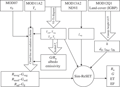
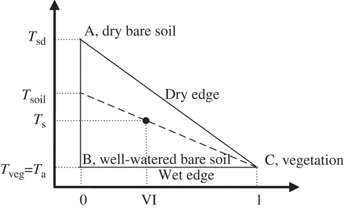
Fig. 2 Obtaining temperature-related parameters from a VI–T s diagram (after Nishida et al. Citation2003).
Firstly, a simple scheme proposed by Bisht et al. (Citation2005) is adopted to estimate instantaneous cloud-free R n using MODIS data. This scheme is independent of ground data and capable of obtaining net radiation with a reasonable accuracy. Water vapour pressure is calculated using dew point temperature at the vertical pressure level of 1000 hPa from MODIS atmospheric profile product (MOD07L2). The soil heat flux is calculated from R n multiplied by the ratio G/R n. The ratio G/R n for the vegetation component is approximated as 0.1 (Boegh et al. Citation2002) and the ratio G/R n for the soil component can be scaled between the ratios of G/R n for dry and wet soils using a scaled temperature (Sun et al. Citation2009).
The roughness lengths for bare soil surfaces, z 0md and z 0hd, are approximated as 0.005 m and 0.0005 m, respectively (Braud et al. Citation1993). The z 0m and d 0 for crops and grasses are estimated as z 0m = 0.123h and d 0 = 0.67h, where h is the canopy height (Monteith Citation1981); they are estimated by z 0m = 0.1h and d 0 = 0.7h for forests (Verseghy et al. Citation1993). Following Garrat and Hicks (Citation1973) and Brutsaert (Citation1979), z 0h is equal to z 0m/2.0 for forests, z 0m/7.0 for crops and z 0m/12.0 for grasses. The values of z 0m, z 0h and d 0 are all dependent on vegetation canopy height. Due to the limitation of current remote sensing techniques in measuring vegetation canopy heights on large spatial scales, the alternative, a look-up table (LUT), is adopted to obtain approximate canopy heights. The canopy heights of forests and shrubs are determined according to the corresponding MODIS IGBP land cover types (). Generally, the heights of forests and shrubs do not change sharply through the four seasons. However, grasses and crops are annual plants, so their canopy heights vary with time through their life cycles. Since the heights of grasses and crops have a linear relationship with vegetation index before their heights reach the maximum, the heights of crops and grasses can be estimated by means of spectral vegetation indices (Turner et al. Citation1999).
Table 2 Look-up table for estimating vegetation canopy heights based on the IGBP land cover classifications
Finally, T sd and T a can be approximately obtained from the dry (or warm) edge of a triangular VI–T s diagram (vegetation index–land surface temperature) plotted for a 20 pixel × 20 pixel moving sampling window (e.g. Sandholt et al. Citation2002) and T soil can also be simply estimated by a linear extrapolation in the triangular VI–T s diagram under an assumption that T veg approximates T a (; Nishida et al. Citation2003). It is noted that the VI–T s diagram may not be well constructed when the ranges of both land surface moisture and VI are incomplete within the 20 pixel × 20 pixel sampling window, such as in the rainy season, or within a period or an area with a narrow VI range (Sun et al. Citation2008, Citation2011). This will result in more uncertainties in estimating T soil, T veg, T sd and T a. Here, a strategy is proposed to decrease these uncertainties. Within a 20 pixel × 20 pixel moving sampling window for plotting a VI–T s diagram under a homogeneous atmospheric forcing, the condition of T sd – T a ≤ 2°C represents two cases: either thoroughly wet (e.g. humid areas, wetland, or areas after a strong rainfall), or thoroughly dry (e.g. desert) within the sampling area. Then ET is approximately regarded as 0 for a dry case and as R n – G for a wet case:
The T s is almost homogeneous within completely wet or dry sampling areas under a homogeneous atmospheric forcing. Considering the 1°C accuracy of MODIS T s retrievals (Wan et al. Citation2004), we took 2°C as a threshold. For completely dry areas, f veg is usually close to 0; for thoroughly wet areas, there is usually extensive vegetation coverage, and f veg is close to 1. Hence, we can take any value of f veg between 0 and 1 as a threshold to distinguish wet and dry cases (0.2 is proposed in this study).
3 STUDY AREA AND DATA USED FOR ET ESTIMATION AND EVALUATION
In this study, ET rates were mapped over the whole Asian continent using only MODIS data products. Ground-based measurements at five sites with different climates in China were used for evaluating the Sim-ReSET model and MODIS-based ET estimates.
3.1 Study area, climate zones and evaluation sites
The study area covers the whole of Asia (). Four climate zones in China and Mongolia were used for the analysis of spatial and temporal patterns of land surface moisture status for different land covers with different climates. China is located in the eastern part of the Asian continent and faces the Pacific, which produces a prominent monsoon climate in eastern China. There is also a vertical climatic zone on the Tibetan Plateau in southwest China and an arid/semi-arid climatic zone in northwest China. Mongolia is located in east-central Asia, between China and Russia, and has an extreme desert/continental climate.
Table 3 Geolocation, climate, terrain, land cover and period of data collection at the five stations
Fig. 3 Asian land-cover map, climatic zones in Mongolia and China, and locations of ecological stations for evaluation.
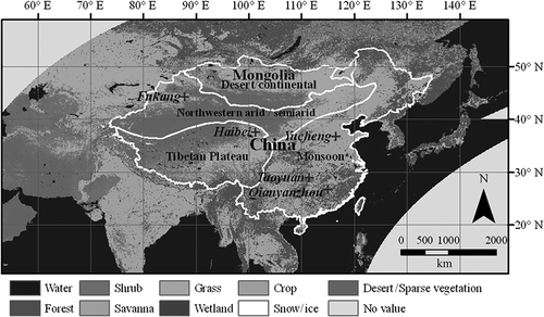
There are five ecological experimental stations (Qianyanzhou, Taoyuan, Yucheng, Haibei and Fukang) representing a wide range of climate, terrain and land cover (). The Qianyanzhou, Taoyuan and Yucheng stations with land cover of forest, paddy and irrigated crops, respectively, are located within the monsoon climatic zone; Haibei station with a grass cover is on the Tibetan Plateau; and Fukang station with a land cover of grass and shrub is located in the arid/semi-arid climatic zone (). To validate remote sensing data products and environmental models, a ground observation network was established at the five stations in 2002 (Wang et al. Citation2004, Watanabe et al. Citation2005). Long-term flux measurements of water vapour, energy and CO2 from a variety of ecosystems across China were implemented and integrated into a consistent, quality-assured and documented data set. The data set also includes half-hour micrometeorological observations and measurements of vegetation characteristics as well as soil physical and chemical properties at the five stations. Note that half-hour eddy covariance, EC, fluxes are available only at Taoyuan, Yucheng and Fukang stations. This data set has played a vital role in validations of satellite remote sensing products and related terrestrial studies (e.g. Wang et al. Citation2005, Sun et al. Citation2007).
3.2 MODIS data used for mapping ET
The MODIS onboard the Terra and Aqua satellites was designed to collect observational data in 36 spectral bands over a wide range at moderate resolutions (250, 500 and 1000 m) to provide almost daily coverage of the Earth (http://modis.gsfc.nasa.gov/). These data products are improving our understanding of global dynamics and processes on Earth and provide input data for generating high-level data products. In this study, three MODIS/Terra land data products were collected from the Land Processes Distributed Active Archive Center (LP DAAC, http://edcimswww.cr.usgs.gov/pub/imswelcome/; tiles: h22–h29, v03–v07; projection: sinusoidal; period: 5 March 2000–6 March 2009): 8-day global 1-km land surface temperature (LST), yearly global 1-km land cover type and 16-day global 1-km vegetation indices. The MOD07L2 product was collected from the Level 1 and Atmosphere Archive and Distribution System (LAADS, http://ladsweb.nascom.nasa.gov/data/search.html) for the same spatial and temporal coverage. In this study, as shown in , vapour pressure (MOD07L2), MODIS LST (MOD11A2) and NDVI (MOD13A2) data were used to derive the available energy, and the MODIS IGBP (the International Geosphere–Biosphere Programme) land cover map (MOD12Q1) () was used to determine canopy heights by means of the LUT.
The MODIS land science team adopted a strategy of maximum composite to decrease the effect of cloud contamination and then improve the availability of meaningful pixels for NDVI and LST images. The 8-day composite land surface temperature product and 16-day vegetation indices are the averages of cloud-free surface temperature and vegetation indices at satellite overpass time during each 8-day and 16-day period, respectively. Therefore, the estimated instantaneous ET based on composited MODIS data products represents the average of several instantaneous values within each 16-day period in this study.
3.3 Ground observation data used for evaluation
We collected LAI, canopy height, and half-hour meteorological data over several years (shown in ) from the five ecological experimental stations. The meteorological data include net radiation, soil heat flux, air temperature, air humidity, wind speed and air pressure. We also collected half-hour EC heat fluxes at the Taoyuan (17 January–17 November 2003), Yucheng (1 January 2004–31 December 2006) and Fukang (22 March–19 October 2003) stations. Relative to other ET methods, the Penman-Monteith (P-M) method has a better performance for ET estimations and, thus, is usually used as the standard for evaluating other methods (Jensen et al. Citation1990, Irmak et al. Citation2003). Details of the P-M method are provided in the FAO Irrigation and Drainage Paper 56 (Allen et al. Citation1998). We compared the EC ET measurements with the ET estimates by the P-M method, and found them to be consistent with each other at the Taoyuan, Yucheng and Fukang stations (see Section 4). Due to many gaps in the EC measurements at Fukang and Taoyuan stations, and the lack of EC data for Haibei and Qianyanzhou stations, in this study the P-M method together with intensive ground-based measurements (R n, G, T a, air humidity, air pressure, wind speed and LAI) was also used to estimate ET rates at the five stations. The ET values along with the available EC measurements corresponding to the Terra satellite's overpass time when the sky was cloudless were selected and averaged for each MODIS 16-day period. These averaged P-M ET and EC ET values were used to evaluate ET estimates from the Sim-ReSET model driven by MODIS data.
4 RESULTS
4.1 Mapping cloud-free ET rates using MODIS data on a continental scale
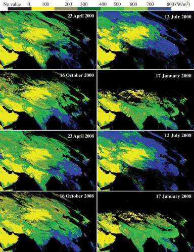
The 16-day 1-km Asian terrestrial ET and EF maps from 5 March 2000 to 6 March 2009 were generated using the Sim-ReSET model and MODIS land data products. We selected ET maps for 23 April, 12 July, 16 October and 17 January in 2000 and 2008 to represent the spatial distribution of ET rates over Asia in the four seasons. clearly shows that ET estimates are relatively large in near-sea humid regions, such as Japan, the Korean Peninsula, the east and south of China, South Asia and Southeastern Asia (displayed in blue and green). In summer, ET estimates in high-latitude regions are also large because of a strong vapour exchange above the boreal forest ecosystem (in blue and green); ET estimates are relatively low in arid and semi-arid areas, such as northwestern China, Mongolia and Central Asia (in yellow). As expected, these spatial and temporal patterns of the Asian ET maps closely correspond to continental scale climates. It is noted that the black regions on the ET maps are oceans or land surfaces where meaningful MODIS LST or vegetation index data are unavailable due to cloud contamination.
Fig. 4 Samples of Asian ET maps in the four seasons in 2000 and 2008 (sinusoidal).
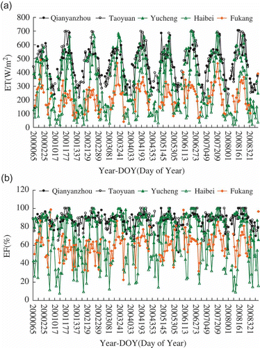
The ET and EF profiles extracted from 16-day Asian ET and EF time series maps are clearly different at the five ecological experimental stations (). The extracted ET and EF values together with MODIS-based R n and G are compared with their ground-based values in Section 4.2. shows that ET and EF values have obvious seasonal variations at the five experimental stations, especially Yucheng, Haibei and Fukang. The ET and EF values at Haibei and Fukang increase sharply in spring because of ice and snowmelt; however, the soil water within the top soil layer and underlying root zone, supplied from ice, snow and limited precipitation, soon diminish due to transpiration, evaporation, infiltration, or runoff, and thus both the ET and EF values decrease sharply. Due to precipitation and adequate irrigation for crops, both ET and EF rates at Yucheng station have large values during growing seasons. Because of ample rainfall the EF values at Qianyanzhou and Taoyuan stations are relatively large throughout the year, and thus the ET values are close to the available energy. As expected, the temporal patterns of the ET and EF time series at the five stations are consistent with their local climates and land covers.
Fig. 5 Profiles of MODIS-based ET (a) and EF (b) from 2000 to 2009 at the five ecological stations.
4.2 Evaluating MODIS-based ET estimates using ground-based data
The MODIS-based ET estimates (ET_MODIS) were compared with the ET measurements from the EC system (ET_EC) at Taoyuan, Yucheng and Fukang stations, and with the ET estimates from the P-M method (ET_P-M) at the five stations. The time series of ET_MODIS, ET_EC and ET_P-M at the Taoyuan, Yucheng and Fukang stations in are consistent with each other. A linear regression analysis between ET_EC and ET_P-M shows that the slope, intercept and R 2 are 0.88, 37.99 and 0.86, respectively (); linear regression analysis between ET_EC and ET_MODIS gives a slope, intercept and R 2 of 0.87, 85.26 and 0.90, respectively (); and linear regression analysis between ET_P-M and ET_MODIS gives values of 0.90, 74.87 and 0.85, respectively ().
Fig. 6 Time series of ET measurements by the EC system (ET_EC), ET estimates by the P-M method (ET_P-M) and MODIS-based estimates (ET_MODIS) at the (a) Taoyuan, (b) Yucheng and (c) Fukang stations.
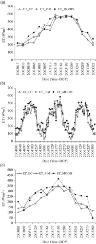
Fig. 7 Inter-comparison of: (a) ET estimates by the P-M method (ET_P-M) vs ET measurements by the EC system (ET_EC); (b) MODIS-based ET estimates (ET_MODIS) vs ET_EC; (c) ET_MODIS vs ET_P-M at three stations; and (d) ET_MODIS vs ET_P-M at all five stations.
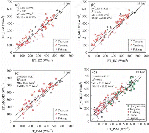
The ET_EC measurements are the direct data against which to evaluate the ET_MODIS estimates from the Sim-ReSET model. The ET_MODIS estimates agree with the ET_EC measurements available at the Taoyuan, Yucheng and Fukang stations (), but tend to be overestimated with a mean error (ME) of 49.39 W/m2 and a root mean square error (RMSE) of 68.01 W/m2 (). The errors vary with climate and land cover. The ME and RMSE are 46.34 and 68.78 W/m2, respectively, for Taoyuan station (humid, paddy), 55.47 and 71.23 W/m2 for Yucheng (semi-arid, irrigated crops) and 28.17 and 50.93 W/m2 for Fukang (arid, grass and shrub). Due to the many gaps in the EC data for Taoyuan and Fukang stations, and the lack of EC data for Qianyanzhou and Haibei stations, the ET_P-M estimates, which are in good agreement with the available ET_EC measurements (ME = 4.42 W/m2, RMSE = 54.51 W/m2; ), are used to further evaluate the Sim-ReSET model for all stations and all evaluation periods. Our results indicate that the ET_P-M estimates are reliable for evaluating the ET_MODIS estimates in place of the ET_EC measurements.
shows that the ET_MODIS estimates are in agreement with the ET_P-M estimates at all five stations. The slope, intercept and R 2 from linear regression analysis are 0.84, 85.65 and 0.88, respectively; the ME and RMSE are 33.08 and 69.53 W/m2, respectively. The ET_MODIS estimates have small errors at Qianyanzhou, Taoyuan and Haibei stations, but large errors at the Yucheng and Fukang stations. shows that the RMSEs (MEs) of ET are 49.56 (–10.00), 61.96 (17.18) and 66.80 (28.25) W/m2 at Qianyanzhou, Taoyuan and Haibei, respectively, but larger, 80.71 (58.31) and 76.85 (56.72) W/m2, at Yucheng and Fukang, respectively. The RMSEs (MEs) of R n and G at the Yucheng and Fukang stations are close to those at the other three stations in both the warm (May–September) and cold (October–April) seasons. Comparing the MODIS-based EF estimates against the EF estimates from the P-M method shows that the RMSEs (MEs) of EF are obviously relatively large at the Yucheng and Fukang stations in both the warm and cold seasons and at the Haibei station in the cold season. Consequently, this leads to large errors in ET_MODIS estimates at Yucheng and Fukang stations in both the warm and cold seasons and at the Haibei station in the cold season.
Table 4 Comparison of MODIS-based R n, G, ET and EF against the ground-based observational R n and G and the P-M-based ET and EF at the five stations
shows the accuracy of MODIS-based ET estimates in previous studies. They have errors of 27–40 W/m2 (RMSE) or 4.3–31% (relative deviation). The comparison of the ET_MODIS estimates against the ET_EC measurements and the ET_P-M estimates based on meteorological data indicates that the accuracy of our MODIS ET product (ME = –10.00 to 58.31 W/m2, and RMSE = 49.56–80.71 W/m2) is comparable to that of MODIS ET estimates presented by previous studies in which re-analysis data or ground-based measurements were involved to drive ET models together with MODIS data.
Table 5 Accuracy of MODIS-based ET estimates in previous studies
4.3 Testing the capability of our ET product to capture spatial and temporal patterns of land surface moisture status in China and Mongolia using MODIS EF product
In order to further evaluate our generated Asian ET product, we tested its capability to capture the spatial and temporal patterns of land surface moisture status for different land covers with different climates. We used the 16-day MODIS EF product to demonstrate the time series of spatially-averaged EF rates throughout Mongolia and three climatic zones in China (), and also to demonstrate the time series of spatially-averaged EF rates for grass, forest and crop lands within these climatic zones (). Note that meaningless EF values due to cloud contamination were excluded for spatial averaging. Four large climatic zones were used for pixel averaging, which could relieve the effect of “black” (useless) pixels on the analysis of spatial pattern of land surface moisture.
Fig. 8 Spatially-averaged EF for the Mongolia desert/ continental climatic zone, and three major climatic zones in China.
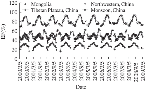
Fig. 9 Spatially-averaged EF for (a) grass; (b) forest; and (c) crop lands in the Mongolia desert/continental climatic zone and three major climatic zones in China.
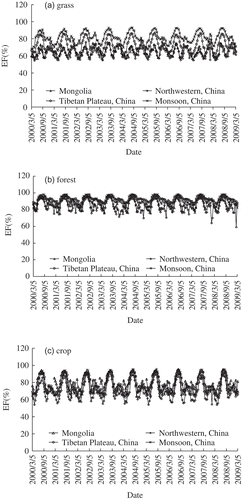
The averaged EF rates indicate the average land surface moisture status of different land covers with different climates on a large scale. As shown in , the spatially-averaged EF rates of the monsoon climatic zone are obviously larger than those of the other climatic zones due to the difference in annual precipitation. The spatially-averaged EF rates in the northwest of China are much lower than those in the other three climatic zones due to its arid/semi-arid climate and the large extent of desert within this zone (). The spatially-averaged EF rates of the Tibetan Plateau climatic zone in China and the Mongolia desert/continental climatic zone are between those of the monsoon and the northwest arid/semi-arid climatic zones.
As expected, the inter-year patterns of spatially-averaged EF rates for each vegetation type (grass, forest and crop) correspond to climates: high values for the monsoon and Tibetan Plateau zones and low values for the northwestern arid/semi-arid and Mongolia desert/continental climatic zones (). The EF rates of grass and crops show obvious seasonal variations due to their annual growing cycles. Compared with grass and crops, the EF rates of forests show the smallest seasonal variation, especially in the Tibetan Plateau climatic zone. The peaks of EF time series for forests in Mongolia and China are similar every year. The main difference comes from EF rates in winter. Most forests in the Tibetan Plateau climatic zone are distributed along the southeastern edge of the Plateau where precipitation is plentiful all year (; Chang Citation1981), so forests there are moist throughout the four seasons, although a weak dry trend exists in winter. This is the reason for larger EF rates for forests in the Tibetan Plateau than forest elsewhere in winter. Desert covers southern Mongolia, and grass covers almost all of northern Mongolia. In China, grassland is distributed mainly in the east of the northwest arid/semi-arid zone, the middle of the Tibetan Plateau, but is scarce in the monsoon zone. Due to more rainfall, spatially-averaged EF rates for grasses in the Tibetan Plateau and monsoon zones are larger than those in Mongolia and northwest China; EF rates for grasses are similar in Mongolia and northwestern China. In China, crop lands are located mainly in the monsoon zone, and the east and west of the northwestern arid/semi-arid zone, but are rare in the Tibetan Plateau. In Mongolia, crop lands occur near the border with Russia. Field management ensures enough water to reach crops, so the seasonal variations of crop EF rates are very similar in all climatic zones.
In conclusion, the spatially-averaged EF rates do reasonably capture the spatio-temporal pattern of land surface moisture status for different land covers within different climates. This is another way of demonstrating that the MODIS-based ET product from the Sim-ReSET model is acceptable for applications.
5 DISCUSSION
The assumptions and parameterizations involved in the Sim-ReSET model and inputs for the model may result in errors and uncertainties in ET estimates. In this study, only instantaneous ET rates were estimated; however, daily ET rates are more useful for hydrological applications. Mapping regular real-time ET exclusively from satellite data is still a challenge. Below, error and uncertainty sources, the potential of the Sim-ReSET model for real-time ET estimation, and the upscaling of ET from instantaneous to daily are discussed in detail.
5.1 Error and uncertainty sources
The RMSE in MODIS-based ET estimates from the Sim-ReSET model ranges from about 50 W/m2 to about 80 W/m2 among different land covers with different climates (). The errors and uncertainties may derive from assumptions and parameterizations in the model, remote sensing inputs and the mismatch of spatial scale in evaluation.
5.1.1 Assumptions
There are three basic assumptions involved in Sim-ReSET: the first is that wind speed is laterally homogeneous at the upper boundary of the atmospheric surface layer; the second is that the Sim-ReSET model works under neutral or near-neutral conditions; and the third is that a reference dry bare soil can be found within a sampling window. Detailed discussion of the first and second assumptions is provided by Sun et al. (Citation2009), and an in situ test showed that Sim-ReSET performs well in estimating ET using ground observational data. As for the third assumption, a reference dry bare soil can be easily found in arid or semi-arid areas, but may be hard to find in thoroughly wet areas. However, available energy is almost fully converted to evapotranspiration in thoroughly wet areas, and thus ET rates for thoroughly wet areas where the reference dry bare soil cannot be found are set as R n – G in this study. shows that EF is close to 1 at the forest (Qianyanzhou) and paddy (Taoyuan) sites during rainy seasons. In and (b), EF is close to 1 for humid forest areas. This indicates that the approximation of ET = R n – G for thoroughly wet areas is reasonable. Therefore, the Sim-ReSET model can work without a reference dry bare soil in wet areas.
5.1.2 Parameterizations
The accuracy of ET estimates is directly related to the derivative parameters (R n, G, h, T sd, T a, T soil and T veg) from the remote sensing inputs. The sensitivity analysis of parameters involved in Sim-ReSET has been presented by Sun et al. (Citation2009). Below are detailed discussions about remote sensing-based parameterizations:
5.1.2.1 Net radiation (R n )
Net radiation was estimated using the scheme of Bisht et al. (Citation2005). This scheme does not consider the effect of topography, and thus R n estimates may not be reliable in mountainous areas. Both the ME and RMSE in R n estimates are less than ˜40 W/m2 in this study. This accuracy is acceptable because the five stations are located in relatively flat areas. Since we have no ground observational data for slopes in mountainous areas, we cannot evaluate the effect of topography on solar radiation and thus ET estimates in this study. However, based on prior studies (Hansen et al. Citation2002, Allen et al. Citation2006), a topographic correction will be combined in Sim-ReSET to improve the accuracies of R n and ET estimates in our future study.
5.1.2.2 Soil heat flux (G)
In most current remote sensing-based ET algorithms, soil heat flux is estimated by means of a ratio of G/R n, which is estimated using a remotely-sensed vegetation index while the ratios for vegetation and bare soil are regarded as constants (e.g. Boegh et al. Citation2002, Su Citation2002). However, the ratio of G/R n for bare soil varies with soil moisture status. The Sim-ReSET model considers the effect of soil moisture status on G/R n for bare soil by means of a scaled temperature (Sun et al. Citation2009). The scaled temperature between air temperature and the surface temperature of dry bare soil can be taken as an indicator of land surface moisture status (Sandholt et al. Citation2002). The ME and RMSE in G estimates have ranges of 8.19–30.92 W/m2 and 19.06–31.94 W/m2, respectively, in this study.
5.1.2.3 Canopy height (h)
Although the Sim-ReSET model is insensitive to h (Sun et al. Citation2009), the accuracy of ET estimates will be still affected if there is a large error in h estimates. In the last decade, some active sensors were developed to obtain consistent estimates of vegetation canopy height, such as Light Detection and Ranging (LiDAR) (e.g. Dubayah and Drake Citation2003) and Synthetic Aperture Radar (SAR) (e.g. Kellndorfer and Ulaby Citation2003). Recent research results from Walker et al. (Citation2007) indicate that the average error of absolute height is 2.1 m for regional- to continental-scale estimates of vegetation canopy height using an Interferometric SAR (InSAR) and passive optical remote sensing. Hence, based on present technologies, vegetation canopy height may not be obtained with an error of less than 2.1 m on large scales. Here, as an alternative, a land cover map-based LUT was used to determine h, although some potential errors still exist. When accurate canopy heights are obtained from new sensors onboard satellites, they are expected to be integrated into the Sim-ReSET model for mapping regional and continental ET rates.
5.1.2.4 Surface temperatures T sd and T a
The Sim-ReSET model is sensitive to T sd and T a (Sun et al. Citation2009). Therefore, the improvement of T sd and T a estimations will increase the accuracy of the ET product. We used a triangular VI–T s diagram to obtain T sd and T a in this study. However, an ideal triangular VI–T s diagram sometimes cannot be well constructed using 1-km MODIS data if the ranges of both land surface moisture and VI are not incomplete within a sampling window. This will result in more errors and uncertainties in the determinations of T sd and T a. Because the ideal triangular VI–T s diagram cannot be easily obtained in fully dry or wet areas, we proposed a strategy to mitigate these errors and uncertainties by setting ET as 0 for the extreme dry case, and R n – G for the extreme wet case. An ideal triangular VI–T s diagram can usually be constructed in semi-humid and semi-arid areas using 1-km MODIS data (Sun et al. Citation2011). Mixed pixel decomposition technologies (Dozier Citation1981, Xu et al. Citation2001, Zhang et al. Citation2003, Cain Citation2004, Sun et al. Citation2008) and remote sensing data with fine resolutions (e.g. ASTER, ETM+) also contribute to constructing an ideal triangular VI–T s diagram.
5.1.2.5 Surface temperatures T soil and T veg
The triangular VI–T s diagram method was used to estimate T soil and T veg, while T veg is assumed to approximate T a (Nishida et al. Citation2003), and thus ETveg is only a function of R nveg – G veg in this study. This assumption is acceptable for well-watered vegetation where almost all available energy is converted to evapotranspiration. However, T veg is usually larger than T a for water-stressed vegetation, and this will result in an overestimation of ET for water-stressed vegetation. Therefore, our MODIS ET product tends to overestimate for water-stressed vegetation. Such overestimation is shown at Yucheng station where irrigated crops are easily water-stressed. This issue is expected to be solved using new methods to effectively obtain T soil and T veg that vary with the moisture condition of vegetation.
5.1.3 Remote sensing input data
The accuracy of ET estimates directly depends on remote sensing input data. Compared with ground-truth observations, remote sensing data still have errors and uncertainties due to their retrieval algorithms and the atmospheric effect on remote sensing observations. We believe that these errors and uncertainties in remote sensing inputs will be mitigated by the application of new technologies for improving retrieval algorithms and atmospheric correction methods. Many MODIS data products have been updated to a new version with a better accuracy. These new data products will contribute to improving the accuracy of ET estimates.
5.1.4 Mismatch of spatial scale in evaluation
The errors in ET estimates vary with stations. This may be caused by the mismatch between flux tower footprints and the MODIS pixel size (1 km × 1 km). There are homogeneous forests, rice paddies and grasses within the 1-km range around the flux towers at Qianyanzhou, Taoyuan and Haibei stations, respectively, so the ET_MODIS estimates at the MODIS pixel scale can agree well with the ET_P-M estimates and the ET_EC measurements at the site scale. However, within the 1-km range around the flux tower at Yucheng station, there is not only cotton but also wheat, maize and other crops. Around the flux tower at Fukang station, there are sparse grasses and shrubs. Hence, the ET_P-M estimates and the ET_EC measurements at the site scale cannot well represent the 1-km ET_MODIS estimates at Yucheng and Fukang stations. This may be a reason for relatively large errors in the ET_MODIS estimates at these two stations.
5.2 Towards a real-time cloud-free evapotranspiration model exclusively using remote sensing data
Many algorithms (or models) are devoted to estimating regional and global ET rates, and these algorithms can be grouped into three categories according to the contribution of remote sensing data to ET algorithms (Matsushita and Fukushima Citation2009). The first is that ET is estimated only using re-analysis data or outputs of general circulation models (GCM). For example, Thomas (Citation2008) estimated monthly ET rates over China and adjacent areas using the P-M method and gridded meteorological data (0.25°) for 1951–1990. The second is that ET is estimated partially from ground-based measurements or re-analysis data (Bastiaanssen et al. Citation1998, Su Citation2002, Leuning et al. Citation2008, Zhang et al. Citation2009). For example, Cleugh et al. (Citation2007) and Mu et al. (Citation2007) improved the P-M method to map regional and global ET rates using ground-based meteorological data and MODIS data such as leaf area index (LAI), land cover, albedo, and enhanced vegetation index. Fisher et al. (Citation2008) improved the Priestley-Taylor method to map monthly global ET rates using Advanced Very High Resolution Radiometer (AVHRR) data and ISLSCP-II data (International Satellite Land-Surface Climatology Project, Initiative II Data Archive). The third is that ET is estimated entirely from satellite remote sensing data. ET is partitioned from land surface available energy by means of EF that can be determined using the scatterplot of T s–VI (Gillies et al. Citation1997, Boegh et al. Citation1999, Venturini et al. Citation2004), or T s-albedo (Verstraeten et al. Citation2005, Fan et al. Citation2007).
All the algorithms mentioned above can estimate regional and even global ET rates, but still have difficulties in generating regular real-time ET maps due to their limitations. The algorithms in the first and second categories are often relatively robust with a sound physical basis, but detailed inputs (e.g. wind speed, humidity, air temperature and surface resistance) have to be derived from ground-based observational data, re-analysis data, or outputs of GCM models. This will limit their applications to areas where the required input data are unavailable. Even if input data can be derived from re-analysis data sets or outputs of GCM models, the poor spatial resolution of the consequent ET rates usually cannot meet its applications on watershed and finer scales. Furthermore, real-time ET rates are difficult to obtain due to the time delay of acquiring input data. Therefore, no regular real-time ET data set has been available to the public before now. The algorithms in the third category can produce real-time ET rates by only using remote sensing data, such as the VI–Ts triangle method (Jiang and Islam Citation1999) and the S-SEBI method (Roerink et al. Citation2000), neither of which can involve the aerodynamic characteristics of the land surface, such as land surface roughness (Sun et al. Citation2009). Therefore, a trade-off approach is to develop a robust ET model whose inputs can be easily derived from satellite remote sensing. Evaluation results from Sun et al. (Citation2009) and this study suggest the Sim-ReSET model could be such a model.
The Sim-ReSET model estimates ET as a residual of the land surface energy balance equation (ET = R n – G – H, where H is the sensible heat flux). Estimating H does not need stomatal resistance. However, the regulation of the transpiration by stomata may be reflected by the cooling effect of transpiration. High surface temperature corresponds to large stomatal resistance and low transpiration, and vice versa. Such a cooling effect occurs for warm climates (whether dry or wet), but may not be the case for cold climates. Taking tundra ecosystems as an example, the dense vegetation canopy has not only relatively large transpiration, but also a relatively high surface temperature which could increase the activity of leaf stomata (Hope et al. Citation2005). This indicates that ET models estimating ET as a residual of the land surface energy balance equation, including the Sim-ReSET model, may need to allow for canopy heat storage in cold climates.
5.3 Upscaling of ET from instantaneous to daily
Although a daily ET product is more useful for applications in hydrology and water resources, only instantaneous ET rates at the Terra satellite overpass time were estimated using MODIS/Terra data in this study due to a lack of daily net radiation estimates from remote sensing. A sinusoidal method can be used to estimate a daily ET rate from an instantaneous ET rate at the satellite overpass time on a cloudless day (Sun et al. Citation2009). This upscaling method seems to be invalid on cloudy days. Li et al. (Citation2009) tried to use a microwave difference vegetation index (EDVI) and ground observational data to estimate ET in a mid-latitude forest. The EDVI can be obtained under both clear and cloudy sky conditions, but the LST is still unavailable from remote sensing under cloudy sky conditions. Therefore, it is still an attractive challenge to obtain actual daily ET rates directly from remote sensing. The EF is remarkably stable during the daytime (Crago Citation1996), so it provides another strategy for extrapolating ET from an instantaneous value to a daily value when daily net radiation is available (Sugita and Brutsaert Citation1991, Brutsaert and Sugita Citation1992). Traditionally, daily net radiation estimation requires ground climatic data (Hurtado and Sobrino Citation2001, Samani et al. Citation2007). Currently, new geostationary-orbiting satellites such as MSG-2 and GOES can observe the Earth more frequently and at finer resolutions, which may allow estimation of daily net radiation at large scales.
6 CONCLUSIONS
The 16-day cloud-free Asian ET maps from 2000 to 2009 were generated using the Sim-ReSET model and MODIS data. The spatio-temporal pattern of ET estimates matches that of climate on a continental scale. Extensive ground observational data from a variety of ecosystems and climates across China were used to evaluate the MODIS-based ET product. The ET_MODIS estimates are in agreement with both the ET_EC measurements and the ET_P-M estimates at three of five sites. Compared with the ET_P-M estimates, a further evaluation for all the five sites and all evaluation periods shows that the ET_MODIS estimates are obtained with relatively low errors for homogeneous forest, paddy and grass lands, and the ME and RMSE are less than or equal to 28.25 and 66.80 W/m2, respectively. Mainly because a 1 km × 1 km heterogeneous MODIS pixel does not match the footprint of a micrometeorological/flux tower, the ET_MODIS estimates show relatively large errors for heterogeneous irrigated crop and sparsely-vegetated lands, and the ME and RMSE are larger than or equal to 56.72 and 76.85 W/m2, respectively. Errors and uncertainties in assumptions and parameterizations in the model, and remote sensing inputs for the model were discussed. The application of EF maps show that the MODIS-based ET product from the Sim-ReSET model is capable of identifying the land surface moisture status for different land covers with different climates.
The further evaluation of the Sim-ReSET model for mapping ET using only MODIS data indicates that the Sim-ReSET model can estimate ET rates with an acceptable accuracy over a wide range of land covers with different climates. However, more validations and improvements are expected to increase the accuracy of ET estimates, and also the Sim-ReSET model is expected to be extended to map actual daily ET rates.
Acknowledgements
This research was supported by the Environment Research and Technology Development Fund (E-1203) of the Ministry of the Environment, Japan, and the GCOM (Global Change Observation Mission) project, sponsored by the Japan Aerospace Exploration Agency (JAXA).
REFERENCES
- Allen, R.G., et al., 1998. Crop evapotranspiration—guidelines for computing crop water requirements. FAO Irrigation and Drainage Paper 56[Accessed 10 March 2010] http://www.fao.org/docrep/x0490e/x0490e00.htm#Contents (http://www.fao.org/docrep/x0490e/x0490e00.htm#Contents)
- Allen , R.G. , Trezza , R. and Tasumi , M. 2006 . Analytical integrated functions for daily solar radiation on slopes . Agricultural and Forest Meteorology , 139 ( 1–2 ) : 55 – 73 .
- Bastiaanssen , W.G.M. 1998 . A remote sensing surface energy balance algorithm for land (SEBAL): 1. Formulation . Journal of Hydrology , 212–213 : 198 – 212 .
- Bisht , G. 2005 . Estimation of the net radiation using MODIS (Moderate Resolution Imaging Spectroradiometer) data for clear sky days . Remote Sensing of Environment , 97 : 52 – 67 .
- Boegh , E. 1999 . A remote sensing study of the NDVI-Ts relationship and the transpiration from sparse vegetation in the Sahel based on high-resolution satellite data . Remote Sensing of Environment , 69 ( 3 ) : 224 – 240 .
- Boegh , E. , Soegaard , H. and Thomsen , A. 2002 . Evaluating evapotranspiration rates and surface conditions using Landsat TM to estimate atmospheric resistance and surface resistance . Remote Sensing of Environment , 79 : 329 – 343 .
- Braud , I. 1993 . Bare-ground surface heat and water exchanges under dry conditions: observations and parameterization . Boundary-Layer Meteorology , 66 : 173 – 200 .
- Brutsaert , W. 1979 . Heat and mass transfer to and from surfaces with dense vegetation or similar permeable roughness . Boundary-Layer Meteorology , 16 : 365 – 388 .
- Brutsaert , W. 1998 . Land-surface water vapor and sensible heat flux: spatial variability, homogeneity, and measurement scales . Water Resource Research , 34 ( 10 ) : 2433 – 2442 .
- Brutsaert , W. and and Sugita , M. 1992 . Application of self-preservation in the diurnal evolution of the surface energy budget to determine daily evaporation . Journal of Geophysical Research , 97 ( D17 ) : 377 – 382 . 18
- Cain , S. 2004 . Bayesian-based subpixel brightness temperature estimation from multichannel infrared GOES radiometer data . IEEE Transactions on Geoscience and Remote Sensing , 42 ( 1 ) : 188 – 201 .
- Carlson , T.N. and Ripley , D.A. 1997 . On the relation between NDVI, fraction vegetation cover, and leaf area index . Remote Sensing of Environment , 62 : 241 – 252 .
- Chang , D.H.S. 1981 . The vegetation zonation of the Tibetan Plateau . Mountain Research and Development , 1 ( 1 ) : 29 – 48 .
- Choudhury , B.J. 1994 . Relations between evaporation coefficients and vegetation indices studied by model simulations . Remote Sensing of Environment , 50 : 1 – 17 .
- Cleugh , H.A. 2007 . Regional evaporation estimates from flux tower and MODIS satellite data . Remote Sensing of Environment , 106 : 285 – 304 .
- Crago , R.D. 1996 . Conservation and variability of the evaporation fraction during the daytime . Journal of Hydrology , 180 ( 1–4 ) : 173 – 194 .
- Dozier , J. 1981 . A method for satellite identification of surface temperature fields of subpixel resolution . Remote Sensing of Environment , 11 : 221 – 229 .
- Dubayah , R.O. and Drake , J.B. 2003 . Lidar remote sensing for forestry . Journal of Forestry , 98 : 44 – 46 .
- Fan , L. 2007 . Regional land surface energy fluxes by satellite remote sensing in the Upper Xilin River Watershed (Inner Mongolia, China) . Theoretical and Applied Climatology , 88 : 231 – 245 .
- Fisher , J.B. , Tu , K.P. and Baldocchi , D.D. 2008 . Global estimates of the land–atmosphere water flux based on monthly AVHRR and ISLSCP-II data, validated at 16 FLUXNET sites . Remote Sensing of Environment , 112 : 901 – 919 .
- Gao , Y. and Long , D. 2008 . Intercomparison of remote sensing-based models for estimation of evapotranspiration and accuracy assessment based on SWAT . Hydrological Processes , 22 : 4850 – 4869 .
- García , M. 2008 . Monitoring land degradation risk using ASTET data: the non-evaporative fraction as an indicator of ecosystem function . Remote Sensing of Environment , 112 : 3720 – 3736 .
- Garrat , J.R. and Hicks , B.B. 1973 . Momentum, heat and water vapour transfer to and from natural and artificial surface . Quarterly Journal of the Royal Meteorological Society , 99 : 680 – 687 .
- Gillies , R.R. and Carlson , T.N. 1995 . Thermal remote sensing of surface soil water content with partial vegetation cover for incorporation into climate models . Journal of Applied Meteorology , 34 : 745 – 756 .
- Gillies , R.R. 1997 . A verification of the ‘‘triangle’’ method for obtaining surface soil water content and energy fluxes from remote measurements of the Normalized Difference Vegetation Index (NDVI) and surface radiant temperature . International Journal of Remote Sensing , 18 ( 15 ) : 3145 – 3166 .
- Hansen , L.B. , Kamstrup , N. and Hansen , B. ULF . 2002 . Estimation of net short-wave radiation by the use of remote sensing and a digital elevation model - a case study of a high arctic mountainous area . International Journal of Remote Sensing , 23 ( 21 ) : 4699 – 4718 .
- Hope , A. , Engstrom , R. and Stow , D. 2005 . Relationship between AVHRR surface temperature and NDVI in Arctic tundra ecosystems . International Journal of Remote Sensing , 26 : 1771 – 1776 .
- Hurtado , E. and Sobrino , J.A. 2001 . Daily net radiation estimated from air temperature and NOAA-AVHRR data: a case study for the Iberian Peninsula . International Journal of Remote Sensing , 22 ( 8 ) : 1521 – 153 .
- Irmak , S. , Allen , R.G. and Whitty , E.B. 2003 . Daily grass and alfalfa-reference evapotranspiration estimates and alfalfa-to-grass evapotranspiration ratios in Florida . Journal of Irrigation and Drainage Engineering, ASCE , 129 ( 5 ) : 360 – 370 .
- Jensen , M.E. , Burman , R.D. and Allen , R.G. 1990 . Evaporation and irrigation water requirement , 332 New York : ASCE Manual No. 70 . American Society of Civil Engineers
- Jiang , L. and Islam , S. 1999 . A methodology for estimation of surface evapotranspiration over large areas using remote sensing observations . Geophysical Research Letters , 26 : 2773 – 2776 .
- Kellndorfer , J.M. and Ulaby , F.T. 2003 . Forest biomass inversion from SAR using object oriented image analysis techniques . IEEE Geoscience and Remote Sensing Symposium , 6 : 3465 – 3467 .
- Leuning , R. 2008 . A simple surface conductance model to estimate regional evaporation using MODIS leaf area index and the Penman-Monteith equation . Water Resources Research , 44 ( W10419 ) et al.doi:10.1029/2007WR006562
- Li , R. , Min , Q. and Lin , B. 2009 . Estimation of evapotranspiration in a mid-latitude forest using the Microwave Emissivity Difference Vegetation Index (EDVI) . Remote Sensing of Environment , 113 : 2011 – 2018 .
- Mallick , K. 2007 . Evapotranspiration using MODIS data and limited ground observations over selected agroecosystems in India . International Journal of Remote Sensing , 28 ( 10 ) : 2091 – 2110 . et al.
- Matsushita , B. and Fukushima , T. 2009 . Methods for retrieving hydrologically significant surface parameters from remote sensing: a review for applications to East Asia region . Hydrological Processes , 23 ( 4 ) : 524 – 533 .
- Monteith , J.L. 1981 . Evaporation and surface temperature . Quarterly Journal of the Royal Meteorological Society , 107 : 1 – 27 .
- Mu , Q. 2007 . Development of a global evapotranspiration algorithm based on MODIS and global meteorology data . Remote Sensing of Environment , 111 : 519 – 536 . et al.
- Mu , Q. , Zhao , M. and Running , S.W. 2011 . Improvements to a MODIS global terrestrial evapotranspiration algorithm . Remote Sensing of Environment , 115 : 1781 – 1800 .
- Nishida , K. , Nemani , R.R. and Running , S.W. 2003 . An operational remote sensing algorithm of land surface evaporation . Journal of Geophysical Research , 108 ( D9 ) : 4270 doi:10.1029/2002JD002062
- Norman , J.M. , Kustas , W.P. and Humes , K.S. 1995 . Source approach for estimating soil and vegetation energy fluxes in observations of directional radiometric surface temperature . Agricultural and Forest Meteorology , 77 ( 3–4 ) : 263 – 293 .
- Patel , N.R. , Rakhesh , D. and Mohammed , A.J. 2006 . Mapping of regional evapotranspiration in wheat using Terra/MODIS satellite data . Hydrological Sciences Journal , 51 ( 2 ) : 325 – 335 .
- Prabhakar , S.V.R.K. and Shaw , R. 2008 . Climate change adaptation implications for drought risk mitigation: a perspective for India . Climatic Change , 88 : 113 – 130 .
- Prata , A.J. 1996 . A new long-wave formula for estimating downward clear-sky radiation at the surface . Quarterly Journal of the Royal Meteorological Society , 122 : 1127 – 1151 .
- Roerink , G.J. , Su , Z. and Menenti , M. 2000 . S-SEBI: a simple remote sensing algorithm to estimate the surface energy balance . Physics and Chemistry of the Earth (B) , 25 : 147 – 157 .
- Samani , Z. 2007 . Estimating daily net radiation over vegetation canopy through remote sensing and climatic data . Journal of Irrigation and Drainage Engineering, ASCE , 133 ( 4 ) : 291 – 297 . et al.
- Sandholt , I. , Rasmussen , K. and Andersen , J. 2002 . A simple interpretation of the surface temperature/vegetation index space for assessment of surface moisture status . Remote Sensing of Environment , 79 : 213 – 224 .
- Sheffield , J. and Wood , E.F. 2008 . Projected changes in drought occurrence under future global warming from multi-model, multi-scenario, IPCC AR4 simulations . Climate Dynamics , 31 : 79 – 105 .
- Su , Z. 2002 . The Surface Energy Balance System (SEBS) for estimation of turbulent heat fluxes . Hydrology and Earth System Sciences , 6 : 85 – 99 .
- Sugita , M. and Brutsaert , W. 1991 . Daily evaporation over a region from lower boundary layer profiles measured with radiosondes . Water Resource Research , 27 : 745 – 752 .
- Sun , Z.G. 2007 . Evaluation of MOD16 algorithm using MODIS and ground observational data in winter wheat field in North China Plain . Hydrological Processes , 21 : 1196 – 1206 . et al.
- Sun , Z.G. 2008 . A new method to define the VI–Ts diagram using subpixel information: a case study over a semiarid agricultural region in the North China Plain . Sensors , 8 : 6260 – 6279 . et al.
- Sun , Z.G. 2009 . Development of a simple remote sensing evapotranspiration model (Sim-ReSET): algorithm and model test . Journal of Hydrology , 376 : 476 – 485 . et al.
- Sun , Z.G. 2011 . Evaluation of the VI-Ts method for estimating land surface moisture index and air temperature using ASTER and MODIS data in the North China Plain . International Journal of Remote Sensing , 32 ( 22 ) : 7257 – 7278 . et al.
- Thomas , A. 2008 . Development and properties of 0.25-degree gridded evapotranspiration data fields of China for hydrological studies . Journal of Hydrology , 358 : 145 – 158 .
- Timmermans , W.J. 2007 . An intercomparison of the Surface Energy Balance Algorithm for Land (SEBAL) and the Two-Source Energy Balance (TSEB) modeling schemes . Remote Sensing of Environment , 108 : 369 – 384 . et al.
- Turner , D.P. 1999 . Relationships between leaf area index and Landsat TM spectral vegetation indices across three temperate zone sites . Remote Sensing of Environment , 70 : 52 – 68 . et al.
- Venturini , V. 2004 . Comparison of evaporative fractions estimated from AVHRR and MODIS sensors over South Florida . Remote Sensing of Environment , 93 : 77 – 86 . et al.
- Verseghy , D.L. 1993 . CLASS-a Canadian land surface scheme for GCMs . II. Vegetation model and coupled runs. International Journal of Climatology , 13 : 347 – 370 . et al.
- Verstraeten , W.W. , Veroustraete , F. and Feyen , J. 2005 . Estimating evapotranspiration of European forests from NOAA-imagery at satellite overpass time: towards an operational processing chain for integrated optical and thermal sensor data products . Remote Sensing of Environment , 96 : 256 – 276 .
- Walker , W.S. 2007 . An empirical InSAR-optical fusion approach to mapping vegetation canopy height . Remote Sensing of Environment , 109 : 482 – 499 . et al.
- Wan , Z. 2004 . Quality assessment and validation of the MODIS global land surface temperature . International Journal of Remote Sensing , 25 ( 1 ) : 261 – 274 . et al.
- Wang , K.C. 2007 . A simple method to estimate actual evapotranspiration from a combination of net radiation, vegetation index, and temperature . Journal of Geophysical Research-Atmospheres , 112 ( D15 ) : D15107 et al.
- Wang , Q.X. , Watanabe , M. and Hayashi , S. 2004 . Monitoring and simulation of water, heat and CO2 fluxes in various terrestrial ecosystems . Acta Geographica Sinica , 59 ( 1 ) : 13 – 24 . in Chinese
- Wang , Q.X. , Watanabe , M. and Ouyang , Z. 2005 . Simulation of water and carbon fluxes using BIOME-BGC model over crops in China . Agricultural and Forest Meteorology , 131 ( 3–4 ) : 209 – 224 .
- Watanabe , M. , Wang , Q.X. and Hayashi , S. 2005 . Monitoring and simulation of water, heat, and CO2 fluxes in terrestrial ecosystems based on the APEIS-FLUX system . Journal of Geographical Sciences , 15 ( 2 ) : 131 – 141 .
- Xu , X. , Chen , L. and Zhuang , J. 2001 . Genetic inverse algorithm for retrieval of component temperature of mixed pixel by multi-angle thermal infrared remote sensing data . Science in China , D44 ( 4 ) : 363 – 372 .
- Zhang , K. 2009 . Satellite based analysis of northern ET trends and associated changes in the regional water balance from 1983 to 2005 . Journal of Hydrology , 379 : 92 – 110 . et al.doi:10.1016/j.jhydrol.2009.09.047
- Zhang , R. , Sun , X. and Liu , J. 2003 . Determination of regional distribution of crop transpiration and soil water use efficiency using quantitative remote sensing data through inversion . Science in China , D46 ( 1 ) : 10 – 22 .
- Zillman , J.W. 1972 . A study of some aspects of the radiation and heat budgets of the southern hemisphere oceans. Meteorol. Study , Vol. 26 , Canberra : Bureau of Meteorology, Department of the Interior .