
Abstract
In determining the possible influence of climate change, it is important to understand the temporal and spatial variability in streamflow response for diverse climate zones. Thus, the aim of this study was to determine the presence of changes in annual maximum peak flow for two climate zones in Chile over the past few decades. A general analysis, a flood frequency analysis and a trend analysis were used to study such changes between 1975 and 2008 for a semi-arid (29°S–32°S) and a temperate (36°S–38°S) climatic zone. The historic annual maxima, minima and mean flows, as well as decadal mean peak flow, were compared over the period of record. The Gumbel distribution was selected to compare the 30-year flood values of two ±15-year intervals, which showed that streamflow decreased by an average of 19.5% in the semi-arid stations and increased by an average of 22.6% in the temperate stations. The Mann-Kendall test was used to investigate the temporal changes in streamflows, with negative trends being observed in 87% of the stations analysed in the semi-arid zone, and positive trends in 57% of those analysed in the temperate zone. These differences in streamflow response between climate zones could be related to recent documented increases in altitude of the zero-degree isotherm in the Andes Mountains of Chile, since most of the significant positive and negative changes were detected in first-order rivers located closer to this mountain range.
Editor D. Koutsoyiannis; Associate editor H. Lins
Citation Pizarro, R., Vera, M., Valdés, R., Helwig, B., and Olivares, C., 2013. Multi-decadal variations in annual maximum peak flows in semi-arid and temperate regions of Chile. Hydrological Sciences Journal, 59 (2), 300–311.
Résumé
Pour déterminer l’influence possible du changement climatique, il est important de comprendre la variabilité temporelle et spatiale de la réponse en débits pour diverses zones climatiques. Ainsi, l’objet de cette étude était de déterminer l’existence de changements dans le débit de pointe maximum annuel de deux zones climatiques du Chili au cours des dernières décennies. Une analyse générale, une analyse de la fréquence des crues et une analyse de tendances ont été utilisées pour étudier les changements des valeurs du débit de pointe maximal annuel entre 1975 et 2008 pour la zone semi-aride (29°S à 32°S) et la zone tempérée (36°S à 38°S). Les maximums, minimums et moyennes historiques annuels, ainsi que le débit de pointe décennal ont été comparés sur la période d’observation. Nous avons choisi la distribution de Gumbel pour estimer les valeurs des crues tricennales (30 ans) de deux intervalles de 15 ans, ce qui a montré que la valeur de ce débit a diminué en moyenne de 19,5% dans les stations semi-arides et augmenté en moyenne de 22,6% dans les stations tempérées. Le test de Mann-Kendall a également été utilisé pour étudier les changements temporels des débits. Des tendances à la décroissance sont observées dans 87% des stations de la zone semi-aride, et des tendances à la croissance dans 57% de celles de la zone tempérée. Ces différences de la réponse en débit entre zones climatiques pourraient être liées à une élévation récemment mise en évidence de l’isotherme zéro degré dans la Cordillère des Andes du Chili, puisque la plupart des changements positifs et négatifs significatifs ont été détectés dans des rivières du premier ordre proches de cette chaîne de montagnes.
INTRODUCTION
Streamflow is a reflection of the influence of atmospheric variables and the anthropogenic behaviour on a watershed (Hodgkins and Dudley Citation2006, Stewart Citation2009). For example, maximum or peak flows tend to increase in response to increased precipitation and snowmelt rates, and their estimation is commonly required in the risk analysis of hydraulic structures (Van Gelder et al. Citation2007, Eum et al. Citation2011). As flooding is a natural non-periodic process (Ollero Citation1996), an understanding of the underlying processes is important in designing infrastructure able to account for possible future extreme flood events, as well as to effectively manage water resources (Linsley et al. Citation1988). Flood frequency analyses are very effective in determining the probabilities of exceedence using successive years of annual maximum peak flow data (Stedinger et al. Citation1993).
With this in mind, research has shown that the rate of glacier melt has increased worldwide over the last few decades. In Chile, most of the glaciers have significantly regressed in response, theoretically, to climate change and the associated increases in temperatures (Rivera et al. Citation2000, Rignot et al. Citation2003). According to the Intergovernmental Panel on Climate Change, mean annual surface air temperature has increased by 0.02–0.05°C per decade during the period 1901–2005 throughout Latin America, with the largest increase of over 0.1°C per decade occurring in southeastern Brazil (Jones et al. Citation2007). In this context, the objective of this study is to determine the presence of changes in annual maximum peak flow for two climate zones in Chile over the past few decades. A general analysis, a flood frequency analysis and a trend analysis were used to analyse annual streamflow data in order to clarify part of the uncertainty surrounding the possible influence of climate change on the hydrological variation found in the two zones under research.
MATERIALS AND METHODS
Study area
Semi-arid zone
The semi-arid climate zone analysed in this study is located between latitudes 29° 02′ S and 32° 16′ S in the Norte Chico natural region of Chile, and pertains to the first-order administrative region of Coquimbo. The region is bordered to the north by the region of Atacama, to the east by Argentina, to the south by the region of Valparaíso, and to the west by the Pacific Ocean. It has a surface area of 40 579.5 km2 and represents 5.36% of the national territory excluding Antarctica (Instituto Nacional de Estadísticas Citation2008).
The following landforms are present in the region: littoral plains and the merged Andes and Coastal mountain ranges, whose east–west-oriented mountains form the Transverse Valleys that cross the region and in which are located three large river basins: the Elqui, Limarí and Choapa (Instituto Nacional de Estadísticas Citation2008). The Elqui, Limarí and Choapa rivers all have a mixed rain- and snow-fed runoff regime, and have drainage basin areas of 9657, 11 297 and 8239 km2, respectively (Cabezas et al. Citation2007). Streamflow information from the Elqui and Limari basins was used for the frequency and trend analyses carried out in this study.
According to the classical worldwide climate classification developed by Köppen (Citation1900), the region has a climate type BWk, i.e. a cold semi-arid climate with annual precipitation not exceeding 400 mm and annual temperatures of less than 18°C (Peel et al. Citation2007). In addition to low temperatures, evaporation is significant at high altitude in the Andes mountain range in the region, which results in a mixed melt regime with maximum streamflow occurring during the spring and summer seasons, mainly from November to December (Favier et al. Citation2009).
Temperate zone
The temperate climate zone analysed in this study is located to the south of the semi-arid zone between latitudes 36°00′S and 38°30′S in the Central and South natural regions of Chile, and pertains to the first-order administrative region of Biobío. The region spans a linear north–south distance of 926 km and is bordered to the north by the region of Maule, to the south by the region of La Araucanía, to the east by Argentina, and to the west by the Pacific Ocean. It has a surface area of 37 062.6 km2 and represents 4.2% of the national territory excluding Antarctica (Instituto Nacional de Estadísticas Citation2008).
In this zone, the following landforms are present: littoral plains that are most well developed in the south of the region, where their width averages 25 km, the Coastal Range in the north that reduces in elevation to a series of rolling hills with intermontane basins in the south, the Nahuelbuta mountain range, the Intermediate Depression and the Andes mountain range. These landforms define two large river basins, the Itata and the Biobío. The Itata River drains an area of 11 204 km2, is located in the north of the region, and is fed by its primary tributaries the Diguillín, Larquie and Ñuble rivers. It has a mixed snow- and rain-fed regime, with maximum streamflows occurring in the autumn and winter seasons, mainly from April to September. The Biobío River is located in the south of the region, drains 24 029 km2 and is the widest river in the country. It also has a mixed regime with maximum streamflow occurring in the winter and spring seasons, most markedly in the Vergara and Laja tributaries (Instituto Nacional de Estadísticas Citation2008). In this case, only annual maximum streamflow data for Itata River basin were used for frequency and trend analysis.
According to Köppen (Citation1900), the region has a Csb climate: a temperate climate with warm, dry summers where the mean temperature does not exceed 22°C during the hottest month and does not drop below 10°C for 4–5 months of the year. This climate is often found as a transitional climate between the hot-summer Mediterranean (Csa) and Oceanic (Cfb) climates, but has milder summers than the Csa climate and, unlike the Cfb climate, its dry season occurs during the hottest months of the year (Peel et al. Citation2007).
Period of record
In this study, stream gauging stations with a period of record of 15 or more continuous years (n ≥ 15) were considered for analysis. In this context, Linsley et al. (Citation1988) noted that there is an 80% probability that the design discharge will be overestimated using a period of record of 20 years and that 45% of these overestimations will surpass the observed values by over 30%. Other authors, such as Pizarro and Novoa (Citation1986), determined that a minimum of 15 years is necessary in order to draw statistical inferences with minimally acceptable precision. With this in mind, 29 stream gauging stations with periods of record between 1975 and 2008 were analysed; 15 are located in the semi-arid zone (latitudes 29°S–32°S) and 14 in the temperate zone (latitudes 36°S–38°S). shows the geographical distribution of the two climate zones and the stations selected for analysis, as well as the boundaries of the analysed basins. In the same sense, shows the periods of record, the drainage basin surface area and the geographical coordinates for each of the analysed stations.
Fig. 1 Study area and location of the selected stations (the stations are described in ).
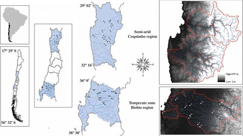
Table 1 Stations used in the study and their characteristics.
General analysis of the historic streamflows
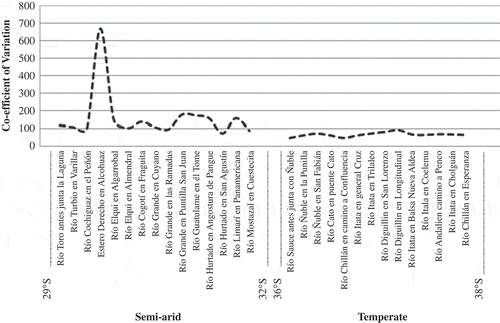
The annual streamflow data set was provided by the Dirección General de Aguas (DGA) of Chile and includes flows for 1975–2008. For each station, the percentage of annual maximum peak flow values above and below the historic annual mean was calculated. Furthermore the annual mean (Qmean), the maximum (Qmax) and the minimum flows (Qmin) were calculated for the whole available period of record in order to establish two indexes: Imax = Qmean/Qmax × 100 and Imin = Qmin/Qmean × 100, with the objective to analyse the differences between the ratios of the maximum and minimum streamflows with respect to the mean for both the semi-arid and temperate zones (). Then the coefficient of variation (CV) was calculated in order to quantify the existing variability between the observed annual peak flows with respect to their means. This measure was calculated to represent the percentage of variation between the standard deviation and the mean flows for each selected station ().
Fig. 2 Annual maximum peak flows, percentage of data above/below the historic mean, and Qmax and Qmin indexes for the semi-arid and temperate zones.
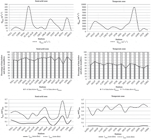
Fig. 3 Coefficient of variation (CV) results for the annual maximum peak flows for all stations located in the semi-arid and temperate zones.
Then a multi-decadal analysis was carried out, dividing the period of record into the following sub-periods: 1970–1979, 1980–1989, 1990–1999 and 2000–2008, with the objective to analyse and compare trends in the streamflow values obtained for each station within each basin.
Flood frequency and trend analysis
A flood frequency analysis was performed using four frequency distribution functions: Gumbel, Goodrich, log-normal and Pearson type III, to determine which distribution most accurately fits the real data, with the objective of selecting one of them for use in the frequency analysis.
The Gumbel distribution (Gumbel Citation1958) was included in the group of the selected probability distribution functions (PDFs) because it had been used in Chile, showing an adequate capacity to fit precipitation and streamflow maxima data (Pizarro Citation1996). The Gumbel distribution is expressed as follows:
The Goodrich distribution is a function that adjusts very well to mean values (Linsley et al. Citation1982). According to Pizarro et al. (Citation1993), the Goodrich distribution is expressed as follows:
where x represents the random variable; α, p and x1 are the adjustment parameters; and e is the Neper constant, as above.
The log-normal distribution (Aitchison and Brown Citation1957) improves on the shortcomings of the normal Gaussian distribution by being able to account for the positive skew commonly found in hydrological data (Chow et al. Citation1994). In this distribution, normal logarithms are used to normalize values by order of magnitude, which then permits the random variable to be analysed using standard normal distribution techniques. The log-normal distribution is expressed as follows:
The classical Pearson type III distribution (Pearson Citation1894) is also one of the most widely used distributions in hydrology, because it is very flexible, diverse and able to normalize annual precipitation and streamflow maxima (Chow et al. Citation1994). It is part of the two-parameter family of continuous probability distributions referred to as Gamma distribution, which can be expressed as follows:
After reviewing the results of the above, the Gumbel distribution was selected for further analysis because it has been widely used for estimating the magnitudes of different hydrological variables, and has been cited extensively in related literature due to its ability to fit extreme values (e.g. Linsley et al. Citation1977, Témez Citation1978, Pizarro and Novoa Citation1986, Chow et al. Citation1994, Pizarro et al. Citation2001, UNESCO Citation2007, Pizarro et al. Citation2012, 2013).
Finally, the Mann-Kendall test (Kendall Citation1938, 1975, Mann Citation1945) was performed to analyse annual streamflow trends for all the stations using a significance of α = 1%. A benefit of this test is that no assumptions about the probability distribution of the data are needed. It has been widely used in the hydro-climatological literature; therefore, details of its calculation are not presented in this study, but can be found in Hipel et al. (Citation1988), Zetterqvist (Citation1991), Chiew and McMahon (Citation1993), Burn (Citation1994), Yulianti and Burn (Citation1998), Lins and Slack (Citation1999), Douglas et al. (Citation2000), Yue and Wang (Citation2004), Yue and Pilon (Citation2004), Burn et al. (Citation2008), Drapela (Citation2011) and Mondal et al. (Citation2012). In the same sense, to estimate the true slope of an existing trend as change per year, the Sen nonparametric method was calculated (Theil Citation1950, Sen Citation1968).
RESULTS AND DISCUSSION
General analysis of the historic streamflows
A first approximation of the behaviour of the historical streamflow is analysed from , which shows the differences between the maximum streamflow values for the semi-arid and temperate climatic zones. The percentage of annual maximum peak flow values above and below the historic mean flow for each analysed station is also presented. For the semi-arid zone, all the analysed gauging stations showed streamflow values below their respective historic mean; e.g. 75% of annual maximum streamflows at Rio Cogotí en Fraguita (COFR) station were less than the historical mean flow. In years when streamflow values above the mean occurred they were found to be mainly associated with outliers related to extreme events occurring in these semi-arid basins, which usually increase the mean flow value (Ashkar et al. Citation1993). Similar results were observed in the temperate zone; however, only around a 70% of the stations showed streamflow values below their respective historic means, and the percentage of annual maximum streamflows below the mean was in general lower than for stations located in the semi-arid zone, e.g. 58% of the annual maximum flows at Rio Ñuble en San Fabián (ÑUSF) station were below the mean value. In general, the percentage of data below and above the historic mean is very comparable for the semi-arid and temperate zones, but the results are more pronounced in the former.
The calculated indexes and
showed totally different results: the average value for
was around 23% in the semi-arid zone, and 47% in the temperate zone, suggesting that in most cases the mean flows are closer to maximum flows in the temperate zone. The average values of
were 11% and 0.63%, respectively, confirming that the ratio between minimum and mean flows is greater in the semi-arid zones.
Annual and multi-decadal streamflow analysis
Using results obtained by analysing the CV, it is possible to indicate that the semi-arid zone showed a higher variability when compared to the temperate zone. The greatest variability in the semi-arid zone was observed in the Estero Derecho en Alcohuaz (EDAL) station (656.4%). In the temperate zone, the greatest variability was observed at the Río Diguillín en Longitudinal (DILO) station (77.3%) ().
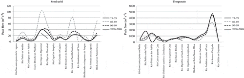
shows that, for 80% of stations in the semi-arid zone, the historic maximum annual peak flow occurred between 1980 and 1989, and for the remaining 20% of stations, between 1990 and 1999. In the temperate zone, the historic maximum annual peak flow occurred between 2000 and 2008 for 64% of stations, between 1990 and 1999 for 21% of stations, and between 1980 and 1989 for the remaining 15% of stations. This analysis can be considered as a first approach to identifying the streamflow trend over recent decades, and suggests a difference between the semi-arid and temperate zones. In the semi-arid zone, lower streamflow values were detected in the more recent decades, and in the temperate zone greater streamflows were detected during the same period. This is true for most of the analysed stations within the corresponding climate zones. For example, Río Elqui en Almendral station (ELALM, semi-arid) showed a decadal mean peak flow value of 55.22 m3 s-1 for 1980–1989, decreasing to 40.21 m3 s-1 for 1990–1999, and finally to 28.05 m3 s-1 for 2000–2008. Other semi-arid stations, Río Elqui en Algarrobal (ELALG), Rio Grande en Puntilla San Juan (GRSJ) and Rio Limari en Panamericana (LIPA), also showed large negative differences when comparing the last two decades in analysis. A decrease in annual maximum peak flow values was observed in the last 8 years (2000–2008) for 87% of the semi-arid stations.
Table 2 The decade in which the historic annual maximum peak flow occurred.
Most stations located in temperate zones showed that streamflows have increased over the last decades, but this trend is not as strong as the decrease observed in the semi-arid zone. Nevertheless, significant changes were also detected, e.g. decadal mean peak flow of Río Ñuble en la Punilla (ÑULP) stationincreased by nearly 300% when comparing the 2000–2008 period with respect to the earlier periods. This recent increase in annual maximum peak flow values was observed for 64% of temperate zone stations ().
Fig. 4 Decadal mean peak flow values for the semi-arid and temperate zones.
Flood frequency and trend analysis
The four frequency distributions (Gumbel, Goodrich, log-normal and Pearson type III) were used to fit the streamflow data and obtain their goodness of fit through K-S and R2 tests (). All four frequency distribution functions fitted the data adequately; however, the log-normal distribution showed the best performance, with a K-S value of 100% for both climatic zones, and average R2 values of 95% and 93% for the semi-arid and temperate stations, respectively. The Gumbel distribution also fit the data very well, with average K-S values of 86.67% and 100%, and average R2 values of 82.30% and 95% for the semi-arid and temperate stations, respectively. The fit with the Goodrich and Pearson type III distributions was significant for fewer stations. For temperate zone stations, the Gumbel PDF fits the data better than the log-normal PDF. However, it was clear that in the semi-arid zone the log-normal PDF fits more accurately because rainfall and streamflow data there have more variability (Pizarro et al. Citation2012).
Table 3 The goodness-of-fit test results for the four distributions for the two climate zones.
The Gumbel PDF was chosen for further analysis of the 30-year flood values because it has been used with good results in diverse hydrological studies in Chile (Pizarro et al. Citation2001, UNESCO Citation2007, 2012, 2013). A return period of 30 years was considered appropriate in the study of temporal streamflow trends in the medium term, because it is one of the periods used in the design of hydrological works such as sewage and drainage systems, and as most of the evidence of climate change has become evident in the most recent decades. For this analysis, the series of each station was divided into two sub-periods: for the semi-arid zone, the 30-year flood values were calculated using 1981–1994 and 1995–2008 data, and for the temperate zone the sub-periods 1975–1990 and 1991–2008 were selected. This difference in the division of the periods of record was based exclusively on the detail that most of the semi-arid stations presented data availability from 1981 onwards, whereas most of the temperate stations have records dating back to 1975. shows the 30-year flood values for both semi-arid and temperate zones. The 30-year peak flow values decreased between 1981–1994 and 1995–2008 at 73% of the semi-arid stations. The most dramatic case was Río Hurtado en Agostura Pangue (HUAP), which fell from 57.75 m3 s-1 in 1981–1994 to 25.4 m3 s-1 in 1995–2008, a 56% of decrease in peak flows. This general decrease in peak flow values in the semi-arid basins can be compared to results obtained by Garreaud et al. (Citation2010), which showed that precipitation in the semi-arid climate zone has decreased regardless of the season. Additionally, they state that precipitation has become concentrated almost exclusively in winter due to the passage of storm fronts, and that evaporation has increased at high altitudes. Favier et al. (Citation2009) indicated that the rivers in the region have a mixed hydrological regime, dominated principally by snowmelt in the summer months, with maximum contributions to streamflow occurring between the spring and summer months of November and December; consequently, decreased streamflows downstream can be attributed to decreases in snow and glacier water storage as a result of a diminished accumulation during the winter months. This can be mainly related to the altitudinal increase in the equilibrium line altitude (ELA), an approximation of the zero-degree isotherm (Carrasco et al. Citation2005, 2008) produced by the temperature increase. Furthermore, the land-use change in recent decades has been significantly related to an increase in agricultural uses; therefore they can be considered as another factor influencing the response of streamflow in these basins.
Table 4 30-year flood values (m3 s-1) for stations located in the semi-arid and temperate zones.
In contrast, in the temperate basins the 30-year flood values between 1975–1990 and 1991–2008 increased at 86% of the analysed stations, most notably at the Río Ñuble en la Punilla (NULP) station, whose values increased by 133.4% (). Similar observations have been made in comparable highly forested regions around the world with the same climate characteristics as the Biobío Region; e.g. an analysis of surface runoff for both large and small watercourses in the Cascade Mountains in western Oregon, USA, showed that peak flow values have gradually increased over the last few years in 90% of drainage basins devoid of vegetation, and in 40% of significantly forested drainage basins (Thomas and Megahan Citation1998). According to Aguayo et al. (Citation2009), the main transformations in land use or change in the Biobío Region can be mostly attributed to the development of forestry, but also to agricultural and urban changes. The same authors indicate that the forest plantation area increased by eight times from 1979 to 2000; and during the same period the urban area increased by around 50%, mainly by encroachment into agricultural areas. It has been estimated that positive land use/cover changes have accounted for over 50% of the reduction in mean annual streamflow for catchments analysed in China by Zhang et al. (Citation2008). Therefore, in the Biobío Region, negative trends should be expected if the hypothesis is based on this statement; however, most of the stations presented positive trends during recent decades. This suggests that the influence of the altitudinal increase in the ELA in these climate zones can be attributed to a combination of a reduction in snowfall and increase in temperatures during the winter months (Burn et al. Citation2008), which produces greater runoff in the areas closer to the mountain ranges. Therefore, the contrasting observed changes in streamflow in the two regions could be explained by the same phenomenon, though it is more accentuated in the semi-arid zone because less forest coverage is present and the agricultural land use has resulted in an increased use of water.
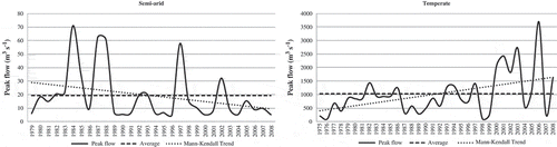
Finally, the Mann-Kendall analysis was carried out to detect possible significant trends in the past decades. The results showed decreasing trends in streamflow in 87% of the analysed stations in semi-arid basins, and increasing trends in 57% of the analysed stations in temperate basins. Furthermore, in most cases, significant negative or positive trends (α ≤ 0.1) were detected only in stations located in first-order streams, i.e. those located closer to the Andes Mountains (). Therefore, it can be noted that these stations are not greatly affected by land-use change, and so it is suggested that the behaviour of the streamflows could be associated with the altitudinal displacement of the zero-degree isotherm. An example of the trends stated can be observed in , which shows the behaviour of the annual maximum peak flow vs the historic mean flow for the stations Río Turbio en el Varillar (TUVA) in the semi-arid zone, and Río Itata en General Cruz (ITGC) station in the temperate zone. In general, the results were consistent at all the levels of analysis, suggesting a decrease in peak flows in the semi-arid basins and an increase in temperate basins.
Table 5 Mann-Kendall test results for stations located in the semi-arid and temperate zones.
Fig. 5 Mann-Kendall trends for annual maximum peak flows at Río Turbio en el Varillar (RTVA) station in the semi-arid zone and Río Ñuble en la Punilla (ÑULP) in the temperate zone.
CONCLUSIONS
Streamflows in the semi-arid and temperate climate basins of Chile have presented different behaviours over the past few decades. Our analyses show that, in general, peak flow values have decreased in the semi-arid zone, and have increased in the temperate zone. These alterations in peak flow are likely due to underlying changes in the atmospheric processes that govern streamflow, possibly as a result of climate change. In this study, the changes in annual maximum peak flow values are suggested to have been caused by recent changes in land use and/or are due to the altitudinal increase in the zero-degree isotherm in the Andes, which can affects streamflow differently depending on the characteristics of the watercourses in question. A 30-year flood analysis was carried out; 30 years is the design period of hydrological works for sewage and drainage systems in Chile, and most of the evidence of climate change has become apparent in the most recent decades. The implications of the streamflow variations described are a reduction in the availability of water resources in the semi-arid zone, and a need for changes in the statistical analysis supporting the design of hydraulic works in the temperate zone. Hydrological models should be used in future studies to thoroughly quantify the possible influence of snowmelt in the streamflow response.
Acknowledgements
The authors would like to express their gratitude for the Dirección General de Aguas de Chile (DGA), a directorate of the Ministry of Public Works, for providing the data used in this study.
REFERENCES
- Aguayo, M., et al., 2009. Land use change in the south central Chile at the end of the 20th century: understanding the spatio-temporal dynamics of the landscape. Revista chilena de historia natural, 82, 361–374.
- Aitchison, J. and Brown, J.A.C., 1957. The lognormal distribution. Cambridge University Press.
- Aparicio, F.J., 1997. Fundamentos de hidrología de superficie. Mexico City: Limusa S.A.
- Ashkar, F., 1993. Robust estimators in hydrologic frequency analysis. In: C.Y. Kuo, et al., eds. Engineering hydrology. New York: American Society of Civil Engineers, 347–352.
- Burn, D., 1994. Hydrologic effects of climatic change in West Central Canada. Journal of Hydrology, 160, 53–70. doi:10.1016/0022-1694(94)90033-7.
- Burn, D.H., Fan, L.I.N., and Bell, G., 2008. Identification and quantification of streamflow trends on the Canadian prairies. Hydrological Sciences Journal, 53 (3), 538–549. doi:10.1623/hysj.53.3.538.
- Cabezas, R., Cepeda, J., and Bodini, A., 2007. Descripción cartográfica de la hoya hidrográfica del río Elqui [online]. Universidad de la Serena. Available from: http://www.parc.ca/mcri/pdfs/geospatial/cabezas_etal_2008.pdf [Accessed 25 May 2009].
- Canavos, G., 1988. Probabilidad y Estadística. Aplicaciones y métodos. Mexico City: McGraw-Hill Interamericana.
- Carrasco, J., Casassa, G., and Quintana, J., 2005. Changes of the 0°C isotherm and the equilibrium line altitude in central Chile during the last quarter of the 20th century/Changements de l’isotherme 0°C et de la ligne d’équilibre des neiges dans le Chili central durant le dernier quart du 20ème siècle. Hydrological Sciences Journal, 50 (6), 933–948. doi:10.1623/hysj.2005.50.6.933.
- Carrasco, J., Osorio, R., and Casassa, G., 2008. Secular trend of the equilibrium-line altitude on the western side of the Southern Andes, derived from radios on de and surface observations. Journal of Glaciology, 54 (186), 538–550. doi:10.3189/002214308785837002.
- Chiew, F. and McMahon, T., 1993. Detection of trend or change in annual flow of Australian rivers. International Journal Climatology, 13, 643–653. doi:10.1002/joc.3370130605.
- Chow, V., Maidment, D., and Mays, L., 1994. Hidrología aplicada. Colombia: McGraw-Hill Interamericana.
- Douglas, E., Vogel, R., and Kroll, C., 2000. Trends in floods and low flows in the United States: impact of spatial correlation. Journal of Hydrology, 240, 90–105. doi:10.1016/S0022-1694(00)00336-X.
- Drapela, K., 2011. Application of Mann-Kendall test and the Sen’s slope estimates for trend detection in deposition data from Bílý Kříž (Beskydy Mts., the Czech Republic) 1997–2010. Beskdy Mendel University in Brno, 4 (2), 133–146.
- Eum, H., et al., 2011. Engineering procedure for the climate change flood risk assessment in the upper Thames river basin. Journal of Hydrologic Engineering, 16, 608–612. doi:10.1061/(ASCE)HE.1943-5584.0000346.
- Favier, V., et al., 2009. Interpreting discrepancies between discharge and precipitation in high-altitude area of Chile’s Norte Chico region (26–32°S). Water Resources Research, 45 (2), W02424. doi:10.1029/2008WR006802.
- Garreaud, R., McPhee, J., and Vicuña, S., 2010. Climate change impacts on the hydrology of a snowmelt driven basin in semiarid Chile. Earth and Environmental Science, 105 (3–4), 469–488.
- Gumbel, E., 1958. Statistics of extremes. Mineola, NY: Dover.
- Hipel, K., McLeod, A., and Weller, R., 1988. Data analysis of water quality time series in lake Erie. Journal of the American Water Resources Association, 24 (3), 533–544. doi:10.1111/j.1752-1688.1988.tb00903.x.
- Hodgkins, G.A. and Dudley, R.W., 2006. Changes in the timing of winter–spring streamflows in eastern North America, 1913–2002. Geophysical Research Letters, 33, L06402. doi:10.1029/2005GL025593.
- Instituto Nacional de Estadísticas, 2008. División Político Administrativa y Censal, 2007 [online]. Instituto Nacional de Estadísticas. Available from: http://www.ine.cl/canales/chile_estadistico/territorio/division_politico_administrativa/pdf/DPA_COMPLETA.pdf [Accessed 5 November 2012].
- Jones, P.D., 2007. Observations: surface and atmospheric climate change. In: S. Solomon, et al., eds. Climate change 2007: the physical science basis. Contribution of Working Group I to the Fourth Assessment Report of the Intergovernmental Panel on Climate Change. Cambridge University Press, 235–336.
- Kendall, M., 1938. A new measure of rank correlation. Biometrika, 30 (1–2), 81–89. doi:10.1093/biomet/30.1-2.81.
- Kendall, M., 1975. Rank correlation methods. London: Griffin.
- Köppen, W., 1900. Versuch einer Klassifikation der Klimate, vorzugsweise nach ihren Beziehungen zur Pflanzenwelt. Geographic Zeitschrift, 6, 593–611, 657–679.
- Lins, H. and Slack, J., 1999. Streamflow trends in the United States. Geophysical Research Letters, 26 (2), 227–230. doi:10.1029/1998GL900291.
- Linsley, R., Kohler, M., and Paulus, J., 1988. Hidrología para ingenieros. 2nd ed. Mexico City: McGraw-Hill Interamericana.
- Linsley, R., Kohler, M., and Paulus, J., 1977. Hidrología para Ingenieros. 2nd ed. Latinoamericana, D.F. México: McGraw-Hill, 386.
- Linsley, R.K., Kohler, M.A., and Paulhus, J.L.H., 1982. Hydrology for engineers. New York: McGraw-Hill.
- Mann, H., 1945. Nonparametric tests against trend. Econometrica, 13, 245–259. doi:10.2307/1907187.
- Mondal, A., Kundu, S., and Mukhopadhyay, A., 2012. Rainfall trend analysis by Mann-Kendall test: a case study of north-eastern part of Cuttack District, Orissa. International Journal of Geology, Earth and Environmental Sciences, 2 (1), 70–78. ISSN: 2277-2081 (Online).
- Ollero, A., 1996. El curso medio del Ebro: geomorfología fluvial, ecogeografía y riesgos. Zaragoza: Consejo de Protección de la Naturaleza de Aragón.
- Pearson, K., 1894. Contributions to the mathematical theory of evolution. Proceedings of the Royal Society of London, 54 (326–330), 329–333.
- Peel, M., Finlayson, B., and McMahon, T., 2007. Updated world map of the Köppen-Geiger climate classification. Hydrology and Earth System Sciences, 11 (5), 1633–1644. doi:10.5194/hess-11-1633-2007.
- Pizarro, R., 1996. Análisis comparativo de modelos matemáticos precipitación-escorrentía en cuencas de la España peninsular. Thesis (PhD). Universidad Politécnica de Madrid.
- Pizarro, R., Abarza, A., and Flores, J., 2001. Análisis Comparativo de las Curvas Intensidad–Duración–Frecuencia (IDF) en 6 Estaciones Pluviográficas (VII Región del Maule, Chile). Universidad de Talca, Facultad de Ciencias Forestales, Talca, Chile. Revista Virtual de UNESCO. 48 p. Available from http://www.unesco.org.uy/phi/biblioteca/bitstream/123456789/500/1/curvas+idf+maule.pdf [Accessed September 2012].
- Pizarro, R., et al., 2013. Inland water bodies in Chile can locally increase rainfall intensity. Journal of Hydrology, 481, 56–63. doi:10.1016/j.jhydrol.2012.12.012.
- Pizarro, R. and Novoa, P., 1986. Elementos técnicos de Hidrología I. Instructivos técnicos. La Serena, Chile: Corporación Nacional Forestal.
- Pizarro, R., et al., 2012. Latitudinal analysis of rainfall intensity and mean annual precipitation in Chile. Chilean Journal of Agricultural Research, 72 (2), 252–261. doi:10.4067/S0718-58392012000200014.
- Pizarro, R., et al., 1993. Elementos técnicos de Hidrología III. Proyecto regional sobre el uso y conservación del recurso hídrico en áreas de América Latina y el Caribe. Universidad de Talca.
- Rignot, E., Rivera, A., and Casassa, G., 2003. Contribution of the Patagonia icefields of South America to sea level rise. Science, 302, 434–437. doi:10.1126/science.1087393.
- Rivera, A., et al., 2000. Variaciones recientes de glaciares en Chile. Investigaciones Geográficas, 34, 25–52.
- Sen, P., 1968. Estimates of the regression coefficient based on Kendall’s tau. Journal of the American Statistical Association, 63, 1379–1389. JSTOR 2285891, MR 0258201. doi:10.1080/01621459.1968.10480934.
- Stedinger, J.R., Vogel, R.M., and Foufoula-Georgiou, E., 1993. Frequency analysis of extreme events. In: D. Maidment, ed. Handbook of hydrology. New York: McGraw-Hill, 18.1–18.69.
- Steel, R.G.D. and Torrie, J.H., 1960. Principios y procedimientos de Estadística. NewYork: McGraw-Hill.
- Stewart, I., 2009. Changes in snowpack and snowmelt runoff for key mountain regions. Hydrological Processes, 23, 78–94. doi:10.1002/hyp.7128.
- Témez, J., 1978. Cálculo hidrometeorológico de caudales máximos en pequeñas cuencas naturales. Madrid: Dirección General de Carreteras, 111.
- Theil, H., 1950. A rank-invariant method of linear and polynomial regression analysis. I, II, III. Nederl. Akad. Wetensch., Proc., 53, 386–392, 521–525, 1397–1412, MR 0036489.
- Thomas, R. and Megahan, W., 1998. Peak flow responses to clear-cutting and roads in small and large basins, Western Cascades, Oregon: a second opinion. Water Resources Research, 34 (12), 3393–3403. doi:10.1029/98WR02500.
- UNESCO, 2007. Curvas Intensidad–Duración–Frecuencia para la zona centro sur de Chile. R. Pizarro et al. Editorial Universidad de Talca, Talca, Chile. Documento Técnico PHI-LAC N° 7. 135 p. Programa Hidrológico Internacional de la UNESCO para América Latina y el Caribe (PHI-LAC), Organización de las Naciones Unidas para la Educación, la Ciencia y la Cultura (UNESCO), Oficina Regional de Ciencia para América Latina y el Caribe, Montevideo, Uruguay.
- Van Gelder, P.H.A.J.M., Wang, W., and Vrigling, J.K., 2007. Statistical estimation methods for extreme hydrological events. In: O.F. Vasiliev, et al., eds. Extreme hydrological events: new concepts for security. Dordrecht: Springer Netherlands, 199–252.
- Yue, S. and Pilon, P., 2004. A comparison of the power of the t test, Mann-Kendall and bootstrap tests for trend detection. Hydrological Sciences Journal, 49 (1), 21–37. doi:10.1623/hysj.49.1.21.53996.
- Yue, S. and Wang, C., 2004. The Mann-Kendall test modified by effective sample size to detect trend in serially correlated hydrological series. Water Resources Management, 18, 201–218. doi:10.1023/B:WARM.0000043140.61082.60.
- Yulianti, J. and Burn, D., 1998. Investigating links between climatic warming and low stream flow in the prairies region of Canada. Canadian Water Resources Journal, 23 (1), 45–60. doi:10.4296/cwrj2301045.
- Zetterqvist, L., 1991. Statistical estimation and interpretation of trends in water quality time series. Water Resources Research, 27 (7), 1637–1648. doi:10.1029/91WR00478.
- Zhang, X., et al., 2008. Responses of streamflow to changes in climate and land use/cover in the Loess Plateau, China. Water Resources Research, 44 (7), W00A07. doi:10.1029/2007WR006711.