Abstract
The Prediction in Ungauged Basins (PUB) initiative of the International Association of Hydrological Sciences (IAHS), launched in 2003 and concluded by the PUB Symposium 2012 held in Delft (23–25 October 2012), set out to shift the scientific culture of hydrology towards improved scientific understanding of hydrological processes, as well as associated uncertainties and the development of models with increasing realism and predictive power. This paper reviews the work that has been done under the six science themes of the PUB Decade and outlines the challenges ahead for the hydrological sciences community.
Editor D. Koutsoyiannis
Citation Hrachowitz, M., Savenije, H.H.G., Blöschl, G., McDonnell, J.J., Sivapalan, M., Pomeroy, J.W., Arheimer, B., Blume, T., Clark, M.P., Ehret, U., Fenicia, F., Freer, J.E., Gelfan, A., Gupta, H.V., Hughes, D.A., Hut, R.W., Montanari, A., Pande, S., Tetzlaff, D., Troch, P.A., Uhlenbrook, S., Wagener, T., Winsemius, H.C., Woods, R.A., Zehe, E., and Cudennec, C., 2013. A decade of Predictions in Ungauged Basins (PUB)—a review. Hydrological Sciences Journal, 58 (6), 1198–1255.
Résumé L’initiative de l’Association internationale des sciences hydrologiques (AISH) sur les prévisions en bassins non jaugés (PUB), lancée en 2003 et conclue en 2012 lors du Symposium tenu à Delft (23–25 Octobre 2012), a été mise en œuvre afin de faire évoluer la culture scientifique de l’hydrologie vers une meilleure compréhension scientifique des processus hydrologiques et des incertitudes associées, et d’élaborer des modèles au réalisme et au potentiel de prévision croissants. Cet article présente une revue du travail réalisé dans le cadre des six thèmes scientifiques de la décennie PUB et souligne les défis qu’il reste à relever par la communauté scientifique hydrologique.
TABLE OF CONTENTS
Introduction
Premises at the beginning of the PUB Decade
What has been achieved?
Data and Process Heterogeneity
Advances in radar and satellite technology
Advances in ground-based observation technology
New data and advances in process understanding through experimental studies
Tracer data and advances in the understanding of transport processes
Advances in understanding of scale dependence through increased data coverage and resolution
Models, Uncertainty Analysis and Diagnostics
Advances in model structure design and modelling strategies
Exploiting new data in catchment models
Advances in model calibration, testing and realism
Advances in model uncertainty assessment
The potential of models as learning tools
Catchment Classification and New Theory
Advances in process and parameter regionalization
Advances in catchment classification and similarity frameworks
Advances towards a new hydrological theory
How did PUB evolve over the decade?
Impact of PUB on the hydrology community and the role of IAHS
What are the challenges and opportunities ahead?
Conclusions
Acknowledgements
References
1 INTRODUCTION
At the beginning of the new Millennium, a community awareness had been reached that hydrological theories, models and empirical methods were largely inadequate for predictions in ungauged basins (PUB; Sivapalan Citation2003a). Furthermore, there was a need for a better comprehension of the links between the hydrological function, i.e. the way a catchment responds to input, and the form, i.e. the physical properties, of a catchment to appropriately address the challenge of ungauged basins (see Wagener et al. 2007, Gupta et al. Citation2008). In other words, it was realized that, in the presence of data scarcity, it would be compelling to infer hydrological function from metrics of catchment form, such as the combined effects of climate, topography, geology, soil type and land use. The vision gradually developed that such a target could only be reached by an improved understanding of the underlying hydrological processes, demanding a shift of the research focus away from parameter fitting towards process understanding and model structural diagnostics.
In addition to the quest for better prediction methods in ungauged basins, a wealth of environmental observations noted considerable change in the hydrological cycle (e.g. Costa and Foley Citation1999, Groisman et al. Citation2004). This has become more obvious over the PUB Decade at all scales ranging from global changes in spatio-temporal temperature and precipitation patterns (e.g. Huntington Citation2006, Burns et al. Citation2007, Sheffield and Wood Citation2008) to regional and local changes in streamflow and hydrochemical regimes (e.g. Burn and Hag Elnur Citation2002, Pfister et al. Citation2004, Cudennec et al. Citation2007, Didszun and Uhlenbrook Citation2008, Whitehead et al. Citation2009, Hu et al. Citation2011, Montanari Citation2012, Tshimanga and Hughes Citation2012). While it was recognized that these changes were most likely driven by the combined effects of a changing climate (e.g. Alcamo et al. Citation2007, Seager et al. Citation2007, Molini et al. Citation2011), land-use changes due to population or economic pressures (Verburg et al. Citation1999, Ye et al. Citation2003, DeFries et al. Citation2010) and long-term dynamics intrinsic to the hydro-climatic system (Koutsoyiannis and Montanari Citation2007, Koutsoyiannis et al. Citation2009), there was, at the beginning of the PUB Decade, no clear understanding of the spatial and temporal scales at which these effects would emerge (Blöschl et al. Citation2007). Together with unreliable climate projections (e.g. Koutsoyiannis et al. Citation2008a), incomplete process understanding was seen as one of the major causes of predictive uncertainty, therefore hindering meaningful predictions of the effect of change (e.g. Pomeroy et al. Citation2005).
The need to address the above challenges, especially with respect to the majority of basins world-wide that are effectively ungauged, followed from the general notion that a wide spectrum of water-related impacts was increasingly undermining the resilience of human society to water-related hazards. These issues were manifest in a range of core water areas, from flood protection (e.g. Kundzewicz and Takeuchi Citation1999), water supply and drought management (e.g. Vörösmarty et al. Citation2000) to water quality issues (e.g. Kundzewicz et al. Citation2008).
Despite the unique importance of water in the Earth system and hydrology’s central role at the interface of numerous disciplines, prior to the advent of PUB, the discipline of hydrology remained fragmented, and lacked, for some aspects, a sufficiently strong scientific/theoretical basis to provide robust, science-based predictions (Sivapalan Citation2003a). The main factors contributing to the resulting predictive uncertainty, as identified by the PUB initiative, included:
an incomplete understanding of the ensemble of processes underlying hydrological system response, and the catchment-scale feedbacks between these processes, frequently resulting in inherently unrealistic models with high predictive uncertainty;
an incomplete understanding of the multi-scale spatio-temporal heterogeneity of processes across different landscapes and climates as the vast majority of small catchments world-wide were, and still remain, ungauged with little or no available information; and
unsuitable regionalization techniques to transfer understanding of hydrological response patterns from gauged to ungauged environments due to a lack of comparative studies across catchments and a lack of understanding of the physical principles governing robust regionalization.
Thus, insufficient process understanding and the lack of concurrent data at multiple space–time scales, as well as the emphasis on localized and isolated research studies, created a situation in which reliable hydrological prediction was frequently made difficult in the relatively few gauged locations world-wide, and effectively impossible for the rest of the world.
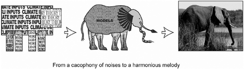
To address these problems, the initiative for Predictions in Ungauged Basins (PUB) of the International Association of Hydrological Sciences (IAHS) was started in 2003 with the release of a 10-year science plan (Sivapalan et al. Citation2003b). Designed as a grass-roots movement, the initiative’s overarching goal was “To formulate and implement appropriate science programmes which engage and energise the scientific community, in a co-ordinated and effective manner, towards achieving major advances in the capacity to make hydrological predictions in ungauged basins.” This strategy implied a major paradigm shift in scientific hydrology, traditionally rooted in empiricism, since it emphasized the need to move away from data- and calibration-focused methods to methods that are more strongly based on theoretical insights into physical processes and system understanding. PUB was designed to benefit the science of hydrology through providing greater coherence to the hydrological science agenda, greater coordination and harmony of scientific activities (), and increased prospects for scientific breakthroughs and, therefore, excitement for the science. The story of the elephant as described by blind people has since become the metaphor for the desire to move towards methods based on physical processes and system understanding.
Fig. 1 The PUB initiative has been designed to lead to a greater harmony of scientific activities, and increased prospects for real scientific breakthroughs. Illustration of the elephant as described by blind people reproduced by permission of Jason Hunt (1999, from Sivapalan et al. 2003).
With this overall goal, the primary research objectives of the PUB initiative were formulated:
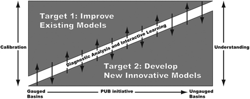
to improve the ability of existing hydrological models to predict in ungauged basins with reduced uncertainty, and
to develop new and innovative models representing the space–time variability of hydrological processes and thereby improve the confidence in predictions in ungauged catchments.
The PUB initiative adopted several, mostly parallel, but strongly interwoven lines of research to achieve the defined objectives. The key strategy of PUB was to extract more information from data, either by more efficient exploitation of available data or by the use of newly acquired data to improve local process understanding in gauged catchments. This understanding was then to be used to design models with an increased degree of process realism at the gauged locations. At the same time, regionally or globally pooled data, together with the process knowledge from gauged locations, were to be used in comparative studies to obtain a better understanding of multi-scale, spatio-temporal heterogeneities in the patterns of hydrological response. This improved understanding of patterns was expected to facilitate the development of more sophisticated regionalization techniques necessary for extrapolating process knowledge to ungauged locations, eventually allowing more reliable predictions in ungauged basins (). In addition, model diagnostics were advanced to better understand uncertainties, and catchment classification methods and similarity frameworks were elaborated. This improved understanding of patterns of hydrological functioning was to provide the basis for the development of a new perspective (and its limitations), in which hydrology is not to be seen as an isolated science, but is actually the central agent at the interface of the co-evolution of climate, geology, topography and ecology and their transient and long-term responses to change. It should be noted that the focus of the PUB initiative was on predictions in ungauged basins, as well as data and process understanding to support these predictions.
Fig. 2 In the quest for better predictions not only in ungauged basins, one initial objective of PUB was to move away from models strongly based on calibration towards those with a stronger emphasis on increased levels of understanding (from Sivapalan et al. 2003).
To mark the completion of the decade on Predictions in Ungauged Basins, which was celebrated with the PUB Symposium 2012, held in Delft (23–25 October 2012), this paper aims to report on the many activities developed over the past decade, the major advances made and the challenges remaining in scientific hydrology. Finally, it briefly provides guidance regarding future research directions following on from the lessons learned over the past 10 years.
2 PREMISES AT THE BEGINNING OF THE PUB DECADE
In the years leading up to the beginning of the PUB Decade in the early 2000s much of scientific hydrology was driven by the quest for understanding whether physically-based, index-based or conceptual models would be preferable for reproducing hydrological processes across a wide range of catchments (see, for example, discussions in Grayson et al. Citation1992, O’Connell and Todini Citation1996, Beven Citation2001a, Todini, Citation2007, Citation2011, Refsgaard et al. Citation2010, Nalbantis et al. Citation2011). This gave rise to a plethora of models of varying complexity and developed with different underlying philosophies. These models include, but are not limited to, the Hydrologiska Byrans Vatenbalansavdelning model (HBV; Bergström Citation1976, Citation1992), the Variable Infiltration Capacity model (VIC; Wood et al. Citation1992), the Sacramento Soil Moisture Accounting model (SAC-SMA; Burnash Citation1995), GR4J (Perrin et al. Citation2003), TOPMODEL (Beven and Kirkby Citation1979), the Distributed Hydrology Soil Vegetation model (DHSVM; Wigmosta et al. Citation1994), the TOPKAPI model (Todini and Ciarapica 2001), and the MIKE-SHE model (Refsgaard and Storm Citation1995), while many more are listed and described elsewhere (e.g. Beven Citation2001c, Singh and Frevet Citation2002, Singh and Woolhiser Citation2002). Some of these models became more widely used than others for a variety of reasons, including, but not limited to, model simplicity, data requirements, code availability and level of documentation or dissemination of the model in the community. Some models have been used in engineering and operational hydrology practice for a long period of time and have evolved over time through the contribution of scientific testing and development. An example is the Pitman model (Pitman Citation1973), developed in South Africa in 1973 and in continuous use as a practical water resources assessment tool ever since, in close feedback with critical scientific scrutiny (e.g. Hughes Citation2004, Hughes et al. Citation2006, Kapangaziwiri et al. Citation2012). However, in spite of a considerable number of similar efforts to improve models and to meaningfully relate model structures to processes in catchments (e.g. Ambroise et al. Citation1996b, Piñol et al. Citation1997), it was not uncommon that models were applied “out of context”, for situations different from those for which they had been developed. One example is the application of general hydrological land surface schemes to cold regions where many key processes were missing or highly mis-represented in the original models (Pomeroy et al. Citation1998). As a result, such models sometimes proved difficult to calibrate with parameter values difficult to explain, and frequently had limited predictive power, thereby promoting a focus on trying to get good model fits to the data, instead of trying to understand what was actually happening in the catchment. Unsurprisingly, this tended to hinder progress in the discipline.
During the PUB Decade, much of the progress in hydrology as a “science” was arguably owed to a handful of guiding insights that, although implicitly understood and vaguely lingering in the heads of many hydrologists long before, now became widely accepted as a necessary basis for further development in hydrology. This occurred only after a series of seminal papers explicitly addressed the relevance of these issues in a detailed manner. One of the main issues that PUB has identified was the lack of generalizable insights from the many experiments, case studies and modelling applications that hydrological research had generated. The thought-provoking discussion of Beven (Citation2000) highlighted the varying importance of different hydrological processes, active at different time scales in different catchments, and thereby emphasized uniqueness of place as a consequence of the variability of nature. This led to the notion that more flexible modelling approaches could prove valuable for a better process understanding, eventually resulting in higher predictive power of models (McDonnell Citation2003, Pomeroy et al. Citation2007). In other words, the idea that models themselves should be systematically treated as hypotheses to be tested gained ground (e.g. Beven Citation2001b), and the widespread habit of implicitly postulating the validity of models was slowly abandoned, thereby opening the door for the use of models as learning tools and bringing proper use of the scientific method to bear (e.g. Popper Citation1959).
Similarly, several authors (Kirchner Citation2006, McDonnell et al. 2007, Wagener Citation2007) expanded on and strongly reiterated Klemeš’ (1986) arguments that models which perform adequately well during calibration, but fail to predict the hydrological catchment response in validation, frequently do so because they do not sufficiently represent the real-world processes that control the catchment response. Rather, their often high number of parameters together with the limited number of constraints (including both calibration objectives and calibration criteria) resulted in high degrees of freedom, i.e. poorly conditioned parameter estimation problems, so that models behaved more like “mathematical marionettes” (Kirchner Citation2006), incapable of reproducing hydrological behaviours under conditions for which they were not previously trained (e.g. Beck and Halfon Citation1991, Perrin et al. Citation2001).
Critical challenges at the beginning of the PUB Decade were thus the need for more powerful diagnostic approaches and a better characterization of uncertainty estimates (e.g. Gupta et al. Citation1998). It was realized that increased physical model realism (and complexity) requires both more input data and more model parameters, which are rarely available with sufficient detail to account for catchment heterogeneity at the required resolution, meaning that some model calibration becomes effectively inevitable (Beven Citation2001a). In turn, the large number of calibration parameters—if they are poorly constrained by the available data—have the freedom to compensate for data error and structural weakness, and can result in considerable parameter equifinality and associated prediction uncertainty. Therefore, a widely acknowledged understanding developed that it is desirable to ensure parameters are well constrained (e.g. using orthogonal diagnostic signatures or global transfer functions to relate physical attributes to model parameters), and to ensure models have a complete and physically realistic representation of dominant processes (e.g. Franchini and Pacciani Citation1991). In all this work, the focus was on error propagation, i.e. how uncertainty in inputs, parameters and model structure propagates to uncertainty in runoff predictions. Increasingly, with the advent of large-sample and comparative hydrology, it was realized that there is also natural or inherent uncertainty in catchment responses, which is amenable to a more stochastic treatment than is included in the current generation of deterministic models (e.g. Koutsoyiannis et al. 2009). This alternative approach to uncertainty estimation has been recognized in the comparative assessment exercise carried out by Blöschl et al. (Citation2013).
The need for better understanding of the connection between small-scale physics and large-scale catchment behaviour represented a further challenge. Although already suggested and discussed early on (Beven Citation1989a, Grayson et al. Citation1992), the importance of the fact that classic small-scale physical laws are not necessarily the sole controls of the hydrological response at the catchment scale was only starting to be fully appreciated (e.g. McDonnell et al. 2007). While appropriate at point, plot and, to a certain degree, also hillslope scales, their control on the hydrological response can gradually be outweighed by emerging patterns and dynamics as the spatial scale increases (see Blöschl Citation2001). An example is the effect of spatial covariance between catchment processes which can lead to aggregated behaviour that is very different from that expected by operation of the averaged set of processes over the catchment (Pomeroy et al. Citation2004). Very much in the sense of Aristotle, “The whole is greater than the sum of its parts”, there was growing consensus that these emergent properties characterizing the ensemble of processes underlying the hydrological response are not the result of mere process aggregation, as is typically represented in bottom-up models (Beven Citation2000). In complex systems characterized by structured heterogeneity, such as catchments, the responses rather arise from nonlinear, yet subtle interactions and feedbacks between the processes involved, gradually manifesting themselves as scale increases (Sivapalan Citation2005). These considerations highlighted the limitations of aggregated performance measures, and pointed towards the use of compact signatures, constructed to describe emergent properties of the system (Eder et al. Citation2003). These signatures included, amongst others, the mean monthly variation of runoff (i.e. the regime curve), the flow duration curve, the flood frequency curve and hydrochemical variation in stream water. Top-down modelling approaches were presented that followed a systematic, hierarchical approach to the development of models of increasing complexity, guided by these runoff signatures (Jothityangkoon et al. Citation2001, Atkinson et al. Citation2002, Farmer et al. Citation2003). This constituted the functional approach to model development (Wagener et al. Citation2007).
In catchment hydrology the activation and de-activation dynamics of drainage networks, such as preferential flow paths, can be deemed such an emergent process, overriding small-scale physical laws governing flow through porous media as controlling principles (McDonnell et al. 2007, Spence and Hosler Citation2007). The development and persistence of such networks is facilitated by the co-evolution of topography, soils, vegetation and hydrology. It is therefore key to acknowledge this to better understand hydrological response patterns at the catchment scale (Cudennec et al. Citation2005, McDonnell et al. 2007, Savenije Citation2010, Wagener and Montanari 2011, Gaál et al. Citation2012). In other words, “reading the landscape” in a systems approach, as traditionally done by geomorphologists, rather than studying the physics of individual small-scale processes becomes crucial as scale increases (Sivapalan Citation2003a, Sivapalan et al. 2003b). Clearly, although landscape evolution can be described with suitable models, “reading the landscape” for hydrological purposes is still frequently a somewhat subjective ad hoc process of perception and, therefore, ways were sought to formalize emergent processes and to develop physically-based governing equations for describing hydrological behaviour at the catchment scale (Kirchner Citation2006, McDonnell et al. 2007). It was pointed out that, in spite of small-scale heterogeneity and process complexity, the hydrological response at the catchment scale is often characterized by surprising process simplicity (Sivapalan Citation2003a), which is a common feature of many complex systems (Savenije Citation2001, Cudennec et al. Citation2004). This led to the hypothesis that top-down models, based on catchment-integrated process representations and effective parameters (see Beven Citation1989a), implicitly accounting for emergent processes, are potential manifestations of system complexity expressing itself in process simplicity at larger scales (Savenije Citation2001), although the underlying physical theory for such top-down models was, and still remains unclear (Sivapalan Citation2005).
As it takes a comparative approach to learn from the differences between catchments around the world, and to shed light on catchments as complex systems, the PUB synthesis book (Blöschl et al. 2013) organizes the findings of the PUB Decade from the perspective of predicting runoff signatures in ungauged basins. This paper, on the other hand, reviews the achievements of the PUB Decade from the perspective of the six parallel PUB science themes—New Approaches to Data Collection, Conceptualization of Process Heterogeneity, New Approaches to Modelling, Uncertainty Analysis and Model Diagnostics, Catchment Classification and New Hydrological Theory—addressing the objectives of PUB in a constant feedback process, with local process understanding being at the interface of the six themes and serving as a common denominator.
3 WHAT HAS BEEN ACHIEVED?
3.1 Data and process heterogeneity
Data provide the backbone of any type of progress in hydrological process understanding and modelling. Both data scarcity and quality were traditionally major problems in hydrology, and are still a source of considerable uncertainty in any type of hydrological application. Sorooshian and Gupta (Citation1983), for example, suggested that it is the quality of data, rather than the quantity, which may be the more important characteristic for a given data set (see review of observational uncertainties for hydrology in McMillan et al. 2012b). As traditional data acquisition is typically subject to financial, logistical and time constraints, innovations and advances in sensing technologies have the potential to be highly valuable for hydrology (e.g. Schmugge et al. Citation2002, Krajewski et al. Citation2006). During the last decade, major steps forward have been made in the availability and quality of a wide variety of environmental data obtained from different observation technologies and strategies. In addition, concerted efforts have been made in developing ways to extract more information from historical and currently already available data (see Soulsby et al. Citation2008). A critical issue is the scale-dependency of data requirements, which requires a hierarchical strategy of data acquisition, as pointed out by Blöschl et al. (2013). Global and low-resolution data sets, generally based on remote sensing, provide generalized information at low cost. Regional data sources of varying availability and accuracy provide more detailed information at higher cost over smaller scales. Finally, with increasing time and financial resources, local observation campaigns, even if limited to short periods, may provide a detailed understanding of the catchment response at the local scale (e.g. Blume et al. Citation2008a).
In the light of advances in data acquisition and exploitation over the last decade, there is now growing consensus that we are at the brink of an age where, in spite of reductions of many ground-based observations due to funding cut-backs, hydrology will, due to the increased availability and quality of remote sensing data, at least no longer be limited by a lack of climate data, and, where new opportunities for data assimilation are emerging, be valuable for improving predictions in ungauged basins (Troch et al. Citation2003).
3.1.1 Advances in radar and satellite technology
Existing technologies, such as weather radar rainfall estimates, not only became more widely available due to an increase of areal coverage, but also uncertainties associated with the estimates could be considerably reduced (e.g. Krajewski et al. Citation2010, Moore et al. Citation2012). In addition, the different sources of uncertainty were identified more reliably, leading to an improved understanding of data quality, and enhanced methods for dealing with uncertainty (e.g. Morin et al. Citation2003, AghaKouchak et al. 2009, Villarini and Krajewski Citation2010).
Similarly, a boost in satellite-borne observation systems gave rise to a wide variety of environmental data now readily and often freely available. For example, the NASA’s Tropical Rainfall Measurement Mission (TRMM), launched in 1997, delivers 3-hourly precipitation totals over the latitude band 50° N–S at a spatial resolution of 0.25° × 0.25° (e.g. Kummerov et al. Citation1998, Huffmann et al. Citation2007). Together with suitable local calibration (e.g. Cheema and Bastiaanssen Citation2012), the availability of such data facilitated hydrological process and modelling studies especially in data-poor regions of Africa (e.g. Hughes et al. 2006, Winsemius et al. Citation2009), Asia (e.g. Shresta et al. Citation2008) and South America (e.g. Collischonn et al. Citation2008, Su et al. Citation2008); it also enabled precipitation estimation over the sea, which is crucial for the global water balance. Due to the notorious scarcity of rainfall data in these regions, this would have been difficult or even impossible otherwise. Such studies were highly instructive to better understand the link between precipitation and hydrological response patterns at regional scale. They further provided the first steps towards filling the extensive gaps in the understanding of global rainfall–runoff partitioning (e.g. Hong et al. Citation2007).
Likewise, the Gravity Recovery And Climate Experiment (GRACE), launched in 2002, provides estimates of changes in total water storage over continental areas, based on gravity anomalies at a spatial resolution of 300–400 km at monthly intervals (Rodell and Famiglietti Citation1999, Cazenave and Chen Citation2010). The possibility of independently estimating changes in water storage gave valuable insights into regional-scale storage and release dynamics (e.g. Rodell et al. Citation2007, Syed et al. Citation2008a, Hafeez et al. Citation2011), as well as into flux partitioning patterns, allowing a better understanding of the feedback between runoff, evaporative fluxes and storage change, and an improvement in the process representation in large-scale models (e.g. Ramilien et al. Citation2006, Winsemius et al. Citation2006, Syed et al. Citation2008b). GRACE has also been used for multi-objective evaluation of the performance of large-scale hydrological models in data-scarce, ungauged regions (Yirdaw et al. Citation2009).
Other missions, such as the Advanced Microwave Scanning Radiometer—EOS (AMSR-E, 25 km × 25 km, Njoku et al. Citation2003) launched in 2002 and the Soil Moisture and Ocean Salinity mission (SMOS, 50 km × 50 km, 3-day interval, Barre et al. Citation2008) launched in 2009, although still under development and thus rarely used in process or modelling studies (e.g. McCabe et al. Citation2008), show the potential to provide robust integrated estimates of soil moisture in near-surface layers (e.g. de Jeu et al. Citation2008, Cheema et al. Citation2011, Kerr et al. Citation2012). The possibility to access such soil moisture estimates will not only be essential for the improvement of the fundamental understanding of unsaturated zone processes at the catchment scale (e.g. Vereecken et al. Citation2008), but will also help to better describe the coupling of soil moisture with precipitation, evaporation and temperature at the regional scale, which will facilitate better prediction of the effects of climate change on the water cycle (see Seneviratne et al. Citation2010). Furthermore, remotely sensed soil moisture has also significant potential for improving runoff predictions in ungauged basins, as demonstrated by Parajka et al. (Citation2009a) with ERS Scatterometer data.
Advances in thermal imagery technology also demonstrated its capacity to estimate soil moisture (e.g. Su et al. Citation2003). Equally important, formulations of the energy balance, based on thermal imagery, are now routinely used to obtain regional-scale evaporation estimates (e.g. Bastiaanssen et al. Citation1998, Citation2005, Franks and Beven Citation1999, Mohamed et al. Citation2004, Citation2006, Anderson et al. Citation2007, Senay et al. Citation2007). Further advanced remote sensing products that have proven valuable for hydrological process studies include amongst others the MODIS snow cover product (e.g. Andreadis and Lettenmaier Citation2006, Parajka and Blöschl Citation2006, Citation2008, Gafurov and Bárdossy Citation2009, Kuchment et al. Citation2010), high-resolution digital elevation models, snow depth and forest canopy characterization as obtained from airborne LiDAR sensors (e.g. Jones et al. Citation2008, Schumann et al. Citation2008, Essery et al. 2009, Li and Wong Citation2010, Hopkinson et al. Citation2012), as well as solutions to remotely sense water levels and inundated areas, providing a way to characterize spatial patterns of river discharge (e.g. Alsdorf and Lettenmaier Citation2003, Alsdorf et al. Citation2007, Smith and Pavelsky Citation2008).
The availability of such remotely sensed data allowed more effective global pooling of data (Owe and Neale Citation2007, Hafeez et al. 2011, Neale and Cosh Citation2012). This helped, not only in comparative approaches to identify global patterns, but also to establish tighter links between climate, catchment characteristics and hydrological function of catchments on multiple scales, thereby providing a cornerstone for deeper synthesis to identify and understand the organizational principles underlying hydrological response patterns and, eventually, for the development of a unified hydrological theory.
3.1.2 Advances in ground-based observation technology
During the PUB Decade, advances in quality, availability and accessibility of remotely sensed data were, albeit with limited reduction of uncertainty, complemented by considerable innovations in ground-based observation technology, including new methods for streamflow measurement (e.g. Hilgersom and Luxemburg Citation2012, Tauro et al. Citation2012), microwave links for estimation of precipitation and evaporation (e.g. Leijnse et al. Citation2007a, Citation2007b), or wireless technologies for data transmission (e.g. Bogena et al. Citation2007, Trubilowicz et al. Citation2009). Further examples include the exploration of geophysical methods, whose potential for hydrological applications, especially for hillslope-scale soil moisture estimation (Robinson et al. Citation2008), has only now begun to be acknowledged. While the methods and protocols for ground-penetrating radar soil moisture estimation are comparatively well developed (e.g. Huisman et al. Citation2003, Lunt et al. Citation2005), the utility of electrical resistivity surveys for soil moisture estimation (e.g. Samouëlian et al. Citation2005) is still limited due to calibration difficulties and redundancies in interpretation. However, its potential in combination with other field methods (e.g. tracer methods) has been demonstrated (e.g. Uhlenbrook et al. Citation2008).
In contrast to large-scale, satellite-based gravity observations (GRACE), terrestrial gravity measurements proved to be valuable, not only to assess soil and aquifer properties (e.g. Jacob et al. Citation2008), as well as water storage dynamics on event and small catchment scales (Creutzfeld et al. Citation2012), but also to evaluate hydrological models (e.g. Naujoks et al. Citation2010). Some studies explored and highlighted the value of ground-based thermal imagery for flow paths and in-stream process identification on the plot/hillslope and reach scales. While Deitchman and Loheide (Citation2009) demonstrated how thermal imagery can be used to visualize saturated–unsaturated zone transitions at a groundwater seepage face, Cardenas et al. (Citation2008) used a thermal camera to describe detailed in-stream temperature dynamics. Others showed how thermal imagery can be used to trace riparian water sources to better understand hillslope–riparian–stream connectivity (Pfister et al. Citation2010), and to detect and quantify localized groundwater inflow into streams (Schuetz and Weiler Citation2011), both of which are crucial for more in-depth understanding of the thresholds and dynamics of multiple interacting flow paths through which water is routed at the hillslope scale. In a different application, Pomeroy et al. (Citation2009) showed how ground-based thermal imagery can be used to improve the conceptualization of forest canopy energetics algorithms in snowmelt models. Similarly, based on image processing technology, Floyd and Weiler (Citation2008) and DeBeer and Pomeroy (Citation2009) demonstrated the utility of off-the-shelf digital cameras for measuring snow accumulation and ablation dynamics. In addition, a portable snow acoustic reflectometry gauge has provided a non-destructive technique to measure snow water equivalent from ground surveys (Kinar and Pomeroy Citation2009).
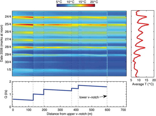
The development of distributed temperature sensing (DTS) techniques using fibre-optic cables (e.g. Selker et al. Citation2006b) resulted in a variety of potential applications, helping to characterize and conceptualize a range of hydrological processes, from stream temperature dynamics (Westhoff et al. Citation2007), snow thermal processes (Tyler et al. Citation2008) and soil moisture estimation (Steele-Dunne et al. Citation2010) to hyporheic exchange (e.g. Slater et al. Citation2010, Westhoff et al. Citation2011, Krause et al. Citation2012) and urban-hydrological applications in sewers (Hoes et al. Citation2009). An example of the DTS technique is shown in , which illustrates the potential of spatial and temporal high-resolution observations that may reveal patterns and processes otherwise undiscovered. During the day time the stream water is warmer than groundwater, so the subsurface inflow sources into the stream are indicated by sudden decreases of the stream temperature along the stream course. Conversely, during the night or early in the morning the stream water is colder than groundwater, so there are sudden increases in the temperature. Based on these observations and a number of assumptions on the thermal characteristics of the system, the exchange fluxes can be estimated.
Fig. 3 Observed continuous longitudinal and temporal temperature profile of the Maisbich stream in Luxembourg between 24 April and 1 May 2006. Clear temperature jumps can be seen at the location of the groundwater inflows (from Selker et al. Citation2006a, © 2006 John Wiley and Sons).
During the PUB Decade, developments outside of hydrology, such as the rise of the open source Arduino development board (arduino.cc/en), allowed hydrologists to develop their own electronic sensors more easily. The range of hydrological measurements was extended by using off-the-shelf sensors, such as accelerometers to measure precipitation (Stewart et al. Citation2012), or game-console remotes to measure water levels (Hut et al. Citation2010), and also measuring tree canopy interception by monitoring stem compression (Friesen et al. Citation2008).
In contrast to remotely sensed information, ground-based observation technology contributed to deepen the detailed process understanding at the local scale. On the way towards the development of a unified hydrological theory, these data will be instrumental for comparative studies to link larger-scale patterns and climatic influences to local hydrological function of catchments. Note that, for brevity, only some highlights of advances in observational technology are given here and many more observation methods were and are currently being developed.
3.1.3 New data and advances in process understanding through experimental studies
New data became available, not only through new technologies and higher observation resolutions, but also—and maybe even more importantly for the fundamental understanding of the link between hillslope- and catchment-scale hydrological processes—through a vast number of in-depth experimental studies. These studies focused on individual or specific aspects of the system and often provided crucial insights into catchment internal water flow dynamics, helping to shape our perception of how water moves through a catchment.
Many of these studies involved detailed observation of variables, such as runoff in nested sub-catchments, piezometric levels, soil moisture or tracer dynamics, all of which are sometimes collectively referred to as “orthogonal information” (e.g. Winsemius et al. 2006, Fenicia et al. Citation2008c), a term that can be misleading, as clearly not all of the variables are strictly independent of each other. The availability of these data in a number of research catchments led, for example, to the insight that in many catchments the groundwater dynamics in the hillslope and riparian zones are effectively decoupled, implying fundamentally different process dynamics for these different landscape elements (e.g. Detty and McGuire Citation2010). For example, McGlynn and McDonnell (2003) and McGlynn et al. (Citation2004) found in the Maimai catchment in New Zealand that, with increasing catchment wetness, runoff generation shifts from the riparian zone to the hillslope, which is largely corroborated by the results from other hillslopes and catchments in different climates and landscapes (e.g. Seibert et al. Citation2003b, Stieglitz et al. Citation2003, Molénat et al. Citation2005, Uchida et al. Citation2006, Jencso et al. Citation2009, Anderson et al. Citation2010). As emphasized by Seibert et al. (2003b), the generality of the steady-state assumption, i.e. groundwater levels rise and fall uniformly over the hillslope and in phase with runoff, as for example implemented in the original version of TOPMODEL (Beven and Kirkby 1979), thus needed to be rejected in favour of more flexible conceptualizations now routinely incorporated in rainfall–runoff models (e.g. Beven and Freer Citation2001a, Seibert et al. Citation2003a, Birkel et al. Citation2010a).
Tightly linked to transient groundwater dynamics are the pattern and dynamics of stormflow generation as already described, for example, by Hewlett and Hibbert (Citation1963), or Whipkey (Citation1965). Although the potential importance of preferential flow as a potential stormflow generation process was realized early on (e.g. Hursh Citation1944, Jones Citation1971, Beven and Germann Citation1982, McDonnell Citation1990, Montgomery and Dietrich Citation1995, Sidle et al. Citation1995), the heterogeneity of preferential flow paths and the lack of suitable observation techniques made its influence on runoff generation difficult to understand. Only recently, a number of process studies, based on a mix of the orthogonal data outlined above, elucidated the role of preferential flows in runoff generation and brought the concept closer to mainstream hydrology. Besides getting a better understanding of the spatio-temporal distribution of preferential flow structures and the resulting implications (e.g. Sidle et al. Citation2001, Vogel et al. Citation2005, Zehe et al. Citation2007), some studies emphasized the importance of preferential infiltration and recharge (e.g. Zehe and Flühler Citation2001, Weiler and Flühler Citation2004, Blume et al. Citation2008b, Salve et al. Citation2012), especially under dry conditions, as envisaged earlier by Horton (Citation1940, see also Beven Citation2004). Exploring water exchange processes between the soil matrix and macro-pores, Weiler and Naef (Citation2003) also found evidence that preferential flow paths can rapidly activate subsurface stormflow as water effectively bypasses the soil matrix, a conclusion that was later supported by the results of similar studies (e.g. van Schaik et al. Citation2008, Anderson et al. Citation2009, Legout et al. Citation2009). In other studies, the temporal dynamics of the generally threshold-driven preferential flow were explored and found to be mainly controlled by antecedent wetness (e.g. Buttle and McDonald Citation2002, Uchida et al. Citation2005b).
A further stormflow generation mechanism, complementary to preferential flow, first suggested by Hewlett (Citation1961), was further elaborated on by Spence and Woo (Citation2003, 2006), also reflecting the results of McNamara et al. (Citation2005), who argued that, in order to generate runoff, water moving through the soil towards the stream needs to first satisfy soil moisture deficits along its flow path. In other words, soil needs to “fill” up to a certain threshold before it can “spill”: the “fill-and-spill” hypothesis. This concept was extended by Tromp-van Meerveld and McDonnell (Citation2006b) with data from an experimental study at the Panola hillslope (Tromp-van Meerveld and McDonnell Citation2006a). They also demonstrated that a certain precipitation threshold needed to be exceeded in order to generate runoff. However, they explicitly linked the fill-and-spill mechanism to irregular bedrock topography (see Freer et al. Citation2002). They argued that the build-up of transient groundwater on the soil–bedrock interface of a hillslope does not immediately generate local lateral flow, but must first fill depressions in the bedrock topography along the flow route before the entire hillslope is sufficiently connected to generate runoff. The fill-and-spill mechanism has been used to describe the variation of catchment contributing areas to stormflow in poorly drained landscapes with substantial depression storage that result from Pleistocene glaciation, such as bed-rock lake and wetland dominated drainage systems (Spence et al. Citation2010, Phillips et al. Citation2011), or prairie wetland dominated systems (Shook and Pomeroy Citation2011). An implication of fill-and-spill mechanisms can be the potential absence of a unique relationship between storage and runoff efficiency in some of these catchments, and that runoff response can display threshold behaviour depending on the catchment “memory” of connectivity in flow systems (e.g. Moore Citation1997, Spence Citation2007), and so the catchment-scale connectivity of surface depression storage must be considered in order to estimate the hydrological response to inputs of rainfall or snowmelt.
Irrespective of the underlying processes, several studies investigated actual stormflow generation thresholds and what is controlling them on the hillslope and small catchment scales. Although flood characteristics are generally highly site specific, a common baseline from process studies, supporting earlier assumptions, was shown to be that stormflow generation and event runoff coefficients are controlled, not only by event precipitation volumes, and antecedent wetness (e.g. Meyles et al. Citation2003, Merz et al. Citation2006, Detty and McGuire Citation2010, McGuire and McDonnell Citation2010, Penna et al. Citation2011), but also by event precipitation intensity (Blume et al. Citation2007, Hrachowitz et al. Citation2011b), stream network connectivity (Jencso et al. Citation2009, Jencso and McGlynn Citation2011, Phillips et al. Citation2011) and storm and inter-storm duration (Carrillo et al. Citation2011).
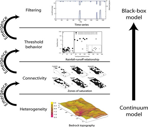
However, it is important to note that the thresholds that must be exceeded to activate flow on the small scale, e.g. to activate one soil pipe, are very different from thresholds triggering flow on the hillslope or at the catchment scale (Hopp and McDonnell Citation2009, Michaelides and Chappell Citation2009, Zehe and Sivapalan Citation2009). An increasing understanding thus developed that hillslope or catchment response thresholds are reflections of the amount of water needed to activate a sufficient number of intermittent small-scale processes, each characterized by an individual process threshold, and to establish hydrological connectivity over the entire domain (, Troch et al. Citation2009a, Zehe and Sivapalan Citation2009, McMillan Citation2012, Ali et al. Citation2013). The difference between these thresholds is tightly linked to the predictability of the system. As thresholds introduce switches in the regime, uncertainties in the initial conditions can result in considerable prediction errors. This results from the fact that small differences in available water determine whether the system reaches the tipping point, or the response threshold, at which it switches quasi-instantaneously from one regime to another, as shown by Zehe and Blöschl (Citation2004). Thus the smaller the scale of interest and the closer the state of the system is to a certain threshold, the poorer the predictability (Blöschl and Zehe Citation2005). The threshold effects discussed above are supported by, for example, the results of hillslope experiments by Anderson et al. (2009), who found that flow velocities in preferential flow features were higher when measured over shorter rather than longer distances as “flow paths are more likely to be connected over shorter than longer distances.” Similarly, Jencso et al. (2009) showed that hillslope–riparian–stream water table connectivity can be a function of contributing area, where large contributing areas cause continuous connection, while small ones lead to transient connections. This also reflects the results of Western et al. (Citation2001), who found that connectivity may change during the year in response to the seasonal cycle of soil moisture. In a modelling study using percolation theory, Lehmann et al. (Citation2007) were able to reproduce the considerably nonlinear response of the Panola hillslope using randomly distributed soil properties, thereby lending further support to the importance of threshold-based connectivity. A detailed overview of the concept of hydrological connectivity is given by Bracken and Croke (Citation2007).
Fig. 4 Based on earlier work by Tromp-van Meerveld and McDonnell (Citation2006a, 2006b), this figure illustrates how local heterogeneities in the subsurface, such as soil pipes, control the hillslope connectivity, and as emergent properties in turn give rise to threshold-like subsurface stormflow response on the small catchment scale (from Troch et al. 2009a, with permission Ciaran Harman, © 2008 Blackwell Publishing Ltd.). It indicates the importance of distinct thresholds controlling emergent behaviour at different scales from the plot to the catchement scale.
Although understanding runoff generation and the mechanisms of water release in catchments is a central question in hydrology, an increasing number of studies also highlighted the need for improving our understanding of how catchments retain water (McNamara et al. Citation2011). This is essential, since: “Changes in storage moderate the fluxes and exert critical controls on a wide range of hydrologic, chemical and biologic functions of a catchment” (Tetzlaff et al. Citation2011b). For example, in detailed studies (Spence Citation2007, Spence et al. 2010, Phillips et al. Citation2011), it was found that the spatial distribution of headwater storage is critical for determining which parts of a catchment contribute to runoff. These studies showed further that the efficiency of a catchment to generate runoff from precipitation depends on where water is stored and on how accessible the storage is to the outlet. Based on detailed field mapping of surface runoff generation types and hydrogeological storage, Rogger et al. (Citation2012a, Citation2012b) have shown that catchment storage can indeed lead to threshold behaviour similar to macropores.
A wide range of process studies was also dedicated to cold-region hydrology (see Carey and Pomeroy Citation2009), with an emphasis on understanding the feedback processes constituting atmosphere–surface energy exchange and thus the accumulation–ablation dynamics of snow (e.g. Pomeroy et al. Citation2003, Granger et al. Citation2006), including the relevance of wind redistribution of snow, and sublimation (MacDonald et al. Citation2010), but also addressing spatial variability of snow-related processes (Pomeroy et al. Citation2004, Clark et al. Citation2011c), the importance of vegetation on snow-pack dynamics (Pomeroy et al. Citation2006, Jost et al. Citation2007, Ellis et al. Citation2011), and the importance of these processes in controlling the contributing area for runoff over frozen ground (DeBeer and Pomeroy Citation2010) and streamflow generation (Quinton and Carey Citation2008, Citation2009, Fang et al. Citation2010, Pomeroy et al. Citation2012).
The wealth of data from process studies during the PUB Decade was instrumental in raising the hydrological community’s awareness of the relevance of thresholds and the potential of complex interactions between threshold-controlled processes (Ali et al. 2013), which is critical for avoiding misinterpretations of the frequently simple response patterns of systems of organized complexity, such as catchments. This is true in particular for threshold-controlled network dynamics for flow generation. However, in spite of considerable advances in detailed process understanding, a wide range of questions still remains to be answered, such as whether a general theory of preferential flow can be formulated as a self-organizing system (e.g. Beven Citation2010). In the adoption of comparative approaches for synthesis, data acquired from process studies are valuable to establish stronger links between the hydrological function of individual catchments, their physical properties and climate. This will be a critical step towards identification of organizational principles and the formulation of a unified hydrological theory (Sivapalan Citation2005). A potentially important component of this endeavour may be the use of controlled experimentation (e.g. Rodhe et al. Citation1996, Kendall et al. Citation2001, Holländer et al. Citation2009). Kleinhans et al. (Citation2010) argued that many major issues in hydrology are open to controlled experimentation. We will address this issue further in Section 4.
3.1.4 Tracer data and advances in the understanding of transport processes
Data obtained from tracer and nutrient transport studies were also highly instructive in advancing the understanding of transport processes and to better link them to the hydrological response. On the hillslope scale, these data helped to improve the conceptualization of mixing processes in the soil. In contrast to common modelling assumptions, complete mixing was realized to be too simplistic to explain transport processes of solutes and particles mainly due to bypass flows in macropores as well as plant transpiration (e.g. Weiler and Naef Citation2003, Grimaldi et al. Citation2009, Brooks et al. Citation2010, Königer et al. Citation2010, Rouxel et al. Citation2011, Klaus et al. Citation2013). At the catchment scale, tracer data helped to understand why stream chemistry frequently exhibits dynamics that are deceptively inconsistent with the runoff response (see Zuber Citation1986, Kirchner Citation2003), which was reflected in the prolonged debate on why stormflow mostly consists of “old” water (e.g. Pinder and Jones Citation1969, Sklash and Farvolden Citation1979, Beven Citation1989b, McDonnell Citation1990, Bishop Citation1991). In most catchments, water is released as discharge over various flow paths. Some of these flow paths, such as macropores, transport water and tracer particles to the stream according to an elevation head in an advective process, which can result in relatively small time lags between the runoff and tracer responses, while other flow paths, such as groundwater, rather translate pressure waves according to a pressure head, sometimes referred to as diffusive processes (Berne et al. Citation2005, Harman and Sivapalan Citation2009). The translation of pressure waves, however, entails an effective decoupling of the hydraulic and tracer responses, i.e. a phase shift, as the celerity of the pressure wave is different from the particle flow velocities (Beven Citation1989b, 2001c, Weiler and McDonnell Citation2007, McDonnell et al. Citation2010).
Correspondingly, the general pattern of transport processes, and thus the sensitivity of catchments to contamination, were in many catchments—mostly based on steady-state analysis—also found to be controlled by the permeability and storage capacity of both soils and bedrock (e.g. Soulsby et al. Citation2004, Citation2006a, Dunn et al. Citation2007, Tetzlaff et al. Citation2007b, Sayama and McDonnell Citation2009, Citation2009a, Katsuyama et al. Citation2010, Speed et al. Citation2010, Harman et al. Citation2011, McGrane et al. Citation2013), whereas in other regions, flow-path lengths (or drainage density) and gradients, or a combination of these factors, emerged as more significant descriptors (e.g. Arheimer and Brandt Citation1998, McGuire et al. Citation2005, Hrachowitz et al. Citation2009a, Tetzlaff et al. Citation2009b, Lyon et al. Citation2010a). Flow into and over thawing frozen ground can dynamically alter flow paths and hydrochemical dynamics, and so frozen soil thermodynamics must be considered in understanding flow paths in cold-region catchments (Lilbaek and Pomeroy Citation2007, Citation2008). In addition, tracer data have allowed assessment of the temporal dynamics of transport processes and, consequently, the assumption that water transit times are wetness dependent became a well-established hypothesis (e.g. McGuire et al. Citation2007, Roa-Garcia and Weiler Citation2010, Botter et al. Citation2011, Rinaldo et al. Citation2011, Hrachowitz et al. Citation2013). Further studies analysing the temporal dynamics in response patterns of transport processes identified antecedent moisture conditions, event precipitation and evaporation as first-order controls on the shape of transport process response functions (e.g. Hrachowitz et al. Citation2009b, Citation2010b, Van der Velde et al. Citation2010, Harman et al. 2011, Heidbüchel et al. Citation2012, McMillan et al. Citation2012a). However, Hrachowitz et al. (Citation2013) pointed out that, to explain the frequently observed hysteresis effects in discharge–tracer concentration relationships (e.g. Weiler and McDonnell Citation2006), it is necessary to take into account not only the amount of water stored, but also where and how in the system it is stored, as previously also highlighted by others (e.g. Moore Citation1997, Spence and Woo Citation2006).
In addition to the continued use of non-conservative tracers, such as water temperature (e.g. Moore et al. Citation2005a, Citation2005b, Gomi et al. Citation2006), the increasing availability of a new generation of tracers, including smart tracers, such as Resazurin (Haggerty et al. Citation2008), synthetic DNA (e.g. Ptak et al. Citation2004, Foppen et al. Citation2011), bacteria (Lutterodt et al. Citation2012), diatoms (Pfister et al. Citation2009) and RFID antennas (Schneider et al. Citation2010), will prove highly beneficial. Such technologies are expected to advance the understanding of catchment-scale transport, especially with respect to enhancing the understanding of mixing processes in different parts of the system (e.g. Legout et al. Citation2007, Van Schaik et al. Citation2008, Godsey et al. Citation2009, Stumpp and Maloszewski Citation2010, Van der Velde et al. Citation2012, Hrachowitz et al. Citation2013, Klaus et al. 2013), which is critical for assessing the ability of catchments to moderate water fluxes, their response and sensitivity to contamination, e.g. peak contamination loads or the persistence of contamination, as well as their resilience to climate and land-use change, thereby providing information on the way individual catchments function.
3.1.5 Advances in understanding of scale dependence through increased data coverage and resolution
Hydrological processes exhibit remarkable heterogeneity at all spatial and temporal scales. In spite of an increased conceptual and quantitative understanding of scaling properties in natural systems (e.g. Gupta et al. Citation1986, Blöschl and Sivapalan Citation1995, Rodríguez-Iturbe and Rinaldo 1997) and their application in models, such as the geomorphological instantaneous unit hydrograph concept (GIUH; Rodriguez-Iturbe and Valdes Citation1979), the question of how these scaling properties actually link to process heterogeneities across different scales (see Dooge Citation1986) remained largely unexplored at the beginning of the PUB Decade. Yet, it was recognized that better insights into scaling relationships are the key to identifying the overarching process controls and eventually to the development of a unified hydrological theory (Sivapalan Citation2005). Observing hydrological processes at multiple scales and characterizing their variability should thus be followed by interpretation in terms of underlying heterogeneities in order to identify the overarching process controls (Sivapalan Citation2005). It is of interest to investigate not only the scale-dependence of processes, but also the presence of thresholds below which process integration dominates over the emergence of new processes.
Many of the aforementioned advances in observation technology allow higher spatial and temporal coverage and resolution of data, critical for hydrology, as the scale at which many environmental variables are observed determines which and how much of the system’s patterns and dynamics become visible to us (see Kirchner et al. Citation2004). It was realized that, due to the nonlinearity of the hydrological system, the need for spatial and temporal averaging or inter-/extrapolation, as determined by the observation scale, can generate considerable bias in both process conceptualizations and model results (Andréassian et al. Citation2004b, Bárdossy and Das Citation2008, Das et al. Citation2008, Dornes et al. Citation2008a, Fenicia et al. Citation2008b, Jost et al. Citation2009, Kumar et al. 2010, Kavetski et al. Citation2011, Singh et al. Citation2012).
For example, a study by Olden and Poff (Citation2003) revealed changing correlations between daily, monthly and annual hydrological indices, which can be observed in different spatial similarity patterns for different catchment-scale signatures (Sawicz et al. Citation2011), thus indicating the different information content of different temporal scales as underlined by Wagener et al. (2007). Similarly, it can be demonstrated that landscape and climate controls on hydrological response pattern are a function of the temporal scale (Son and Sivapalan Citation2007). However, the lack of suitable observation techniques dictates the need for temporal averaging in many applications (e.g. precipitation sampling for chemical analysis), thereby reducing peaks, introducing phase shifts, and potentially concealing system-relevant response patterns and processes featuring shorter time scales (e.g. Bronstert and Bárdossy Citation2003, Hrachowitz et al. Citation2011a). While basic hydro-climatic variables, such as precipitation, temperature and stream stage, are routinely available at relatively high temporal resolutions, frequently with observation intervals of 1 h or less, especially the long-term, high-frequency retrieval of water samples for chemical analysis is still difficult. However, a handful of projects, sampling precipitation and stream water at sub-daily and daily intervals, showed the value of such data for learning more about the short-term dynamics of stream water chemistry and catchment-scale transport processes (Kirchner et al. Citation2000, Tetzlaff et al. Citation2007a, Berman et al. Citation2009, Birkel et al. Citation2012, Neal et al. Citation2012).
Complementary to efforts on the plot and hillslope scales (see Section 3.1.3), a variety of studies also attempted to explore the potential emergence of different processes, i.e. spatial scale dependency and threshold behaviour, on the catchment scale. While some studies found evidence for relationships between catchment processes and catchment scale (e.g. Wolock et al. Citation1997, Buffam et al. Citation2007, Buttle and Eimers Citation2009, Dawson et al. Citation2009, Frisbee et al. Citation2011, Tetzlaff et al. Citation2011a), results of other studies tend to support process convergence at the scale of the study catchments; in other words, they support the notion that downstream response patterns reflect the integrated or averaged upstream influences without further unaccounted processes emerging (e.g. McGlynn et al. 2003, Shaman et al. Citation2004, McGuire et al. 2005, Uchida et al. Citation2005a, Soulsby et al. Citation2006b, Asano et al. Citation2009, Tetzlaff et al. 2009b, Capell et al. Citation2011), thereby highlighting the importance of headwaters (see Bishop et al. Citation2008). Interpreting these findings, Frisbee et al. (Citation2012) argued that, on the catchment scale, there is evidence that the presence and degree of scale dependence are a manifestation of the degree of spatio-temporal process heterogeneity in catchments. Thus, when a scale is reached that is larger than the scale of the underlying process, scale dependence is lost (e.g. Asano et al. Citation2002, Shaman et al. Citation2004, Hrachowitz et al. 2010a), which, however, in the case of multifractal variability (e.g. precipitation), or at larger scales of variability, might never be the case. However, in spite of considerable progress in the understanding of spatial scale dependence, aspects of the question, in particular those related to predictability, still remain unresolved (see Ali et al. 2013).
3.2 Models, uncertainty analysis and diagnostics
3.2.1 Advances in model structure design and modelling strategies
Until the beginning of the PUB Decade, the proliferation of off-the-shelf modelling software led to a polarization between different modelling groups and substantial effort went into determining what model types (physically-based models vs index models vs conceptual models) were universally preferable. There was a tendency to hide behind acronyms, which blocked the communication and the advancement of science. In other words, instead of testing the most suitable model for a particular “unique” catchment setting, which is also often constrained by a lack of suitable data, leaving all tested model designs equally uncertain (Hughes Citation2006, Uhlenbrook et al. Citation2010), a model code was often examined for its ability to be universally applicable. The universal use of the same code has a number of advantages, such as limited requirement for training of personnel (Le Moine et al. Citation2007), better understanding of parameter dependencies and easier regionalization (Oudin et al. Citation2008a), and a number of models have indeed been demonstrated to be applicable across a wide range of climate and physiographic conditions (e.g. Hughes Citation1997, Perrin et al. Citation2003, Gan and Burges Citation2006, Pietroniro et al. Citation2007, Semenova and Vinogradova Citation2009, Carrillo et al. 2011, Vinogradov et al. Citation2011, Strömqvist et al. Citation2012).
During the PUB Decade, an increasing understanding of the importance of openness towards different approaches, and the willingness to communicate and search for opportunities developed. In other words, modelling started to be more curiosity- and less prestige-driven than before. This led to a much more open attitude towards modelling and cross-fertilization between concepts, for example mixing mechanistic descriptions with data assimilation, experimenting with algorithms, merging methods and using multi-basin approaches to test assumptions, agreeing that no model is perfect. The modelling process and assumptions involved became more important than the model acronym. Several model comparison studies (e.g. Gan and Burges Citation1990b, Francini and Pacciani 1991, Perrin et al. Citation2001, Reed et al. Citation2004, Duan et al. Citation2006, Rutter et al. Citation2009) supported this emerging understanding, finding that, generally, no single model performs consistently best, but rather that individual model performances vary with the setting.
The model structure represents a formalized perception of how the catchment system is organized and how the various parts are inter-connected (Blöschl et al. Citation2008). Selection of a suitable model structure ideally depends on a number of factors as one strives to represent the runoff processes in a realistic way, so that the model can be safely used in a predictive mode. However, the level of detail with which this is done varies widely. Blöschl et al. (2013) identified three groups of information that can be used to guide model structure selection in view of process fidelity: a priori perception of processes, field data and reading of the landscape, and transferring the model structure from similar gauged catchments. Additional considerations in selecting a model structure are the modelling purpose (e.g. operational vs investigative models), data availability (more complex models require larger data availability), resource constraints (simpler models with lower budgets), and the modeller’s experience (choosing models one has experience with). However, as emphasized by many authors, including Clark et al. (Citation2011b), ambiguities in the choice of model structure have led to a plethora of models, and the community has struggled to identify the “most appropriate” models even in the relatively simple terms of “best empirical performance”, let alone in terms of their scientific validity. The on-going debate of how to best represent catchment processes can thus be seen as a symptom of an insufficient scientific understanding of hydrological processes at multiple scales. On the one hand, this is partly rooted in difficulties in appropriately measuring and representing the heterogeneity encountered in natural systems (McDonnell et al. 2007, Clark et al. Citation2011b), and thus to adequately answer the “closure” problem at the catchment scale (Reggiani et al. Citation1998, Citation1999, Beven Citation2006a, Harman et al. Citation2010). On the other hand, the proliferation of hydrological models is also clearly linked to the lack of a holistic hydrological theory (Sivapalan Citation2005, Troch et al. 2009a). Thus, in response to the limitations of universally applicable approaches, calls for more flexible approaches to modelling, allowing consistent comparison and testing of alternative model hypotheses (e.g. Beven Citation2000, McDonnell Citation2003, Pomeroy et al. 2007, Clark et al. Citation2008, Savenije Citation2009, Clark et al. Citation2011b, Fenicia et al. Citation2011) found increasing support during the PUB Decade.
Probably the first, widely communicated flexible modelling framework was the Modular Modeling System (MMS), introduced by Leavesley et al. (Citation1996) and consisting of a module library and a GIS interface, allowing the design of user-selected model structures. The main purpose of the MMS was to link different modules aimed at representing different catchment compartments to constitute an integrated system model. In this respect, it may be useful to differentiate between “model-interfacing frameworks” and “flexible process representation frameworks” depending on the model “granularity” and underlying rationale (see Fenicia et al. Citation2011, for a discussion). Subsequently, the Rainfall–Runoff Modelling Toolbox (RRMT) with the associated Monte-Carlo Analysis Toolbox (MCAT) offered a choice of pre-defined conceptual soil moisture accounting modules and routing components that could be combined in different set-ups, thus allowing the modeller some freedom in customizing the model to catchment characteristics (Wagener et al. Citation2001, Citation2004).
Originally designed as a model diagnosis tool, the Framework for Understanding Model Structural Errors (FUSE) was introduced by Clark et al. (2008). In a quest for a better understanding of the differences between model structures and their respective suitability for differential boundary conditions, FUSE uses individual model components of four existing conceptual hydrological models—PRMS (Leavesley et al. Citation1983), NWS Sacramento (Burnash et al. Citation1973), TOPMODEL (Beven and Kirkby 1979) and ARNO/VIC (Zhao Citation1977)—as independent building blocks which can be freely reassembled to customized model architectures. As an extension to the FLEX modelling framework (Fenicia et al. Citation2006, 2008a), which is a more generic approach, Fenicia et al. (Citation2011) presented a unified modelling platform for conceptual hydrological modelling, SUPERFLEX, based on generic building blocks, such as reservoirs, junctions and constitutive functions. Using combinations of these components, tailor-made model architectures can be developed and tested for suitability. With a strong focus on snow accumulation and ablation processes, and frozen soil behaviour in the context of both cold and warm season hydrology, similar to the Hydrograph model (Vinogradov et al. Citation2011, Semenova et al. Citation2013), Pomeroy et al. (2007) devised a modular modelling framework, the Cold Regions Hydrological Model (CRHM), allowing the user to adapt the ensemble of represented processes to correspond to the particular requirements of individual catchments. Similar to the MMS (Leavesley et al. 1996), the CRHM does not require much parameter calibration. The CRHM also permits internal algorithm and parameter set intercomparison, and model falsification through use of parallel model structures. Further frameworks that allow the integration of model components include the Land Information System (LIS; Kumar et al. Citation2006) and the Noah Land Surface Model with multiparameterization options (Noah-MP; Niu et al. Citation2011).
Linking these flexible modelling frameworks to the wide body of literature suggesting that different landscape types entail distinct hydrological functions (e.g. Andréassian Citation2004, Buttle et al. Citation2005, Oudin et al. Citation2008b), and that changes in the landscape can considerably influence the hydrological regime of catchments (e.g. Hundecha and Bárdossy Citation2004, Moore and Wondzell Citation2005, Samaniego and Bárdossy Citation2006, Alila et al. Citation2009, Yang et al. Citation2012), implicitly commands that, ideally, the most suitable model structure identified for a catchment should bear a conceptual resemblance to the modellers’ perception of the system, reflecting the dominant processes at a specific location (e.g. Gan and Burges Citation1990a, Ambroise et al. Citation1996b, Beven and Freer Citation2001a, Pomeroy et al. 2005, Ye et al. Citation2012, Fenicia et al. Citation2013). This is also echoed by the dominant runoff process concept (DRP; Grayson and Blöschl Citation2000) and the development of suitable decision schemes, permitting the identification of distinct hydrological response units (HRU) based largely on geological, pedological and topographical considerations (Scherrer and Naef Citation2003, Pomeroy et al. 2007, Scherrer et al. Citation2007, Schmocker-Fackel et al. Citation2007). The distinct hydrological function of the individual response units then dictates the design of different model structures associated with them, thereby guiding model development (e.g. Uhlenbrook et al. Citation2004, Lindström et al. Citation2010, Hellebrand et al. Citation2011). In addition to applications of the HRUs in catchments with comparatively little anthropogenic disturbance, the concept also proved valuable for holistic representations of water fluxes in heavily human-modified environments, as demonstrated in recent examples (Efstratiadis et al. Citation2008, Nalbantis et al. 2011, Strömqvist et al. 2012). In a somewhat contrasting approach, rather than explicitly defining hydrological function, GIUH models (Rodriguez-Iturbe and Valdes Citation1979) interpret hydrological behaviour of the stream network by means of Horton ratios, while the width function instantaneous unit hydrograph models (WFIUH; Surkan Citation1969, Kirkby Citation1976, Beven Citation1979, Naden Citation1992, Rinaldo and Rodriguez-Iturbe Citation1996, Rodríguez-Iturbe and Rinaldo 1997) make use of response time distributions obtained from physically-based flow velocity parameters, thereby incorporating process heterogeneity, which was shown to be a valuable tool in ungauged environments (e.g. Moussa Citation2008, Grimaldi et al. Citation2010, Citation2012a, Citation2012b).
In a further development, Savenije (Citation2010) explicitly invoked the self-organizing nature of catchments and the fact that flow paths have to reflect the dynamic equilibrium between drainage and storage functions of a catchment, pointing out the potential of landscape-driven modelling. In other words, as a result of the co-evolutionary nature of topography, ecosystem and hydrology, catchments need to store certain amounts of water, while still allowing efficient drainage, for the present vegetation and/or topography to have developed as they did (see Horton Citation1933, Sivapalan Citation2003b). Savenije (Citation2010) further argued that catchments could be dissected in a semi-distributed way according to a hydrologically meaningful landscape classification metric that allows individual runoff processes to be assigned to different landscape units, thus enabling them to be associated with distinct hydrological functions such as can be explored in, for example, Dynamic TOPMODEL (Beven and Freer 2001). The proposed classification is not explicitly based on detailed catchment parameters as in the DRP approaches, but rather on the readily available Height Above the Nearest Drainage (HAND; Rennó et al. Citation2008, Nobre et al. Citation2011), which, according to Gharari et al. (Citation2011), has the potential “to meaningfully characterize landscapes as it originates directly from feedback processes between water and landscape and is [ … ] directly linked to the dominant driver of storage–discharge relationships: the hydraulic head.”
Going somewhat against the mainstream of flexible modelling approaches, data-based mechanistic modelling strategies (DBM; e.g. Young Citation1992, Citation2003, Alvisi et al. Citation2006, Ratto et al. Citation2007) proved highly valuable, in particular for real-time forecasting. Over the past decade, the growing importance of DBM, which, in contrast to the objectives of PUB, pays less attention to the physical interpretation of hydrological processes but rather focuses on the information content of data, is underlined by the development of “hydroinformatics” as an individual sub-discipline in hydrology. Data-based methods are also frequently used to characterize baseflow recessions via the construction of (non)linear master recession curves (e.g. Tallaksen Citation1995, Lamb and Beven Citation1997, Moore Citation1997, Wittenberg and Sivapalan Citation1999, Fenicia et al. 2006). Kirchner (Citation2009) took the idea a step further and elegantly demonstrated that the complete rainfall–runoff response of a certain class of catchments (e.g. Teuling et al. Citation2010, Ajami et al. Citation2011, Birkel et al. Citation2011b) can be described as a simple first-order nonlinear system and the constitutive function generating their streamflow response can be directly inferred from observed streamflow fluctuations. This one-equation approach requires a maximum of four parameters, while resulting in comparable levels of performance to much more complex models. In addition, while compactly describing the water storage and release dynamics of catchments, the proposed approach can also be inverted to estimate spatially averaged precipitation and actual evaporation rates, in the light of the minimal parameterization, providing a strong test for the underlying theory. In a different approach, invoking long-range dependence (e.g. Koutsoyiannis Citation2002, Citation2005), the value of stochastic models for river flow prediction was underpinned by Koutsoyiannis et al. (Citation2008b).
3.2.2 Exploiting new data in catchment models
It was recognized early (Beven Citation1989a, Grayson et al. Citation1992, Jakeman and Hornberger Citation1993, Gupta et al. Citation1998) and strongly reiterated later (e.g. Gupta et al. Citation2008) that the predictive capability of hydrological models is limited by high model complexity relative to the typically low number of model constraints used to calibrate the models. In other words, models calibrated only to observed hydrographs can be considered over-parameterized if they consist of more than five parameters (Jakeman and Hornberger Citation1993). Widening the scope of hydrological models, requiring them to better reproduce multiple aspects of the system simultaneously, proved to be an important step forward (e.g. Kuczera Citation1983, Gupta et al. Citation1998, Citation1999, Vrugt et al. Citation2003, Samaniego and Bárdossy Citation2005, Bastidas et al. Citation2006, Yilmaz et al. Citation2008, Hughes Citation2010). An important strategy to reach this objective was the incorporation of orthogonal, sometimes “soft” forms of information, i.e. more qualitative data and often requiring some level of interpretation, in the modelling process. For example, Seibert and McDonnell (Citation2002) reported that the inclusion of fuzzy measures of acceptability, e.g. for groundwater dynamics, resulted in significantly improved and more consistent overall model performances. Similarly, Freer et al. (Citation2004) used fuzzy estimates of water table depth as additional calibration constraints to considerably reduce the number of feasible model parameterizations. Further “soft” and orthogonal information shown to be valuable for better process representation and more robust parameter estimation, in spite of the potential need for more parameters, included monthly water balance estimates (Winsemius et al. 2009), diatoms (Pfister et al. 2009), single (Vaché and McDonnell Citation2006, Dunn et al. Citation2007, Iorgulescu et al. Citation2007, Page et al. Citation2007, Son and Sivapalan Citation2007, Birkel et al. Citation2010b, Hrachowitz et al. Citation2013) and multiple tracer data (Meixner et al. Citation2002, Birkel et al. Citation2011a, Capell et al. Citation2012), as well as, on the way to integrated catchment models, combinations of tracer data with sub-catchment runoff (e.g. Uhlenbrook and Sieber Citation2005), groundwater dynamics (e.g. Fenicia et al. Citation2008a), or saturation area extent (e.g. Ambroise et al. Citation1996a, Birkel et al. 2010a). Assimilating remotely sensed data into catchment models is particularly relevant for predictions in otherwise ungauged basins. Nester et al. (Citation2012a), for instance, demonstrated the value of remotely sensed snow cover patterns to constrain parameter uncertainty of catchment models. Others (Mohamed et al. 2006, Parajka et al. Citation2006, Winsemius et al. Citation2008) used remotely sensed soil moisture and evaporation, respectively, to improve model parameterizations. In contrast, Lerat et al. (Citation2012) found that using catchment internal flow measurements as additional calibration targets provided only little model improvement. An example is given in of how different data types, in this case of groundwater dynamics and stream tracer response, can enhance process representations in models. The progress in the use of multi-response field data thus not only enhanced the integrated understanding of dominant processes, but also guided the design and parameterization of integrated catchment models (see Ambroise et al. Citation1996b, Lindström et al. Citation2005, Clark et al. Citation2011a, McMillan et al. Citation2012b). Such robust representations of catchment internal process dynamics also increase the value of models for nutrient and contaminant transport studies (e.g. Molénat and Gascuel-Odoux Citation2002, Lyon et al. Citation2010b, Van der Velde et al. 2010, Arheimer et al. Citation2011, Citation2012, Strömqvist et al. 2012, Hrachowitz et al. Citation2013).
Fig. 5 Performance of a model with respect to streamflow (Fq), groundwater dynamics (Fw) and stream tracer response (Fi). Step-wise model improvements from the least complex SoftModelq (red) to the most complex SoftModeli (yellow) determine the orthogonal trajectory in objective space (from Fenicia et al. Citation2008a, © 2008 John Wiley and Sons).
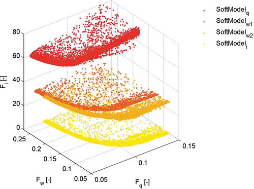
3.2.3 Advances in model calibration, testing and realism
Hydrological models typically rely on calibration, traditionally done by minimizing some performance measure of the residuals between the observed and the modelled hydrograph, defined in terms of an objective function to be optimized. In the absence of an objective function that could give a global, generalized and comparable overall performance assessment of the hydrograph (or any other modelled variable), the choice of the objective function can have significant impacts on model results and parameterization (e.g. Sorooshian et al. Citation1983). The Nash-Sutcliffe Efficiency (NSE; Nash and Sutcliffe Citation1970) is one of the objective functions that became popular as a convenient and normalized measure of model performance. However, besides it being oversensitive to peak flows, due to the use of squared residuals (Legates and McCabe Citation1999), some studies have cast doubt on the usefulness of the NSE for comparative purposes (Seibert Citation2001, Mathevet et al. Citation2006, Schaefli and Gupta Citation2007). While McMillan and Clark (Citation2009) suggested a modified version of NSE, Smith et al. (Citation2008) introduced decomposed performance measures that individually account for bias, variability and correlation. Reflecting this work, Gupta et al. (Citation2009) introduced the Kling-Gupta Efficiency (KGE), similarly based on a decomposed analysis of the form of the NSE. They showed that, when maximizing NSE, the variability in the modelled flows necessarily underestimates the variability in the observed flows (or corresponding target model output), a tendency that KGE is able to avoid. Criss and Winston (Citation2008), however, argued that replacing NSE with a volumetric efficiency (VE) avoids the overemphasis of peak flows. In contrast, methods based on weighting different parameterizations for low- and high-flow periods (Oudin et al. Citation2006a) or different calibration objectives (Fenicia et al. Citation2007b) allow a balanced representation of the hydrograph. A further recently suggested objective metric, Series Distance, is based on an overall agreement of event occurrence as well as on amplitude and timing, bringing automated calibration techniques closer to visual hydrograph inspection (Ehret and Zehe Citation2011, Ewen Citation2011).
Notwithstanding the modifications of old and the design of new objective functions, Krause et al. (Citation2005) found, from a comparative study with a suite of performance measures, that many of the tested performance measures exhibited no, or sometimes even inverse, correlations with each other, concluding that combinations of contrasting objective functions should be used for model calibration to ensure a balanced model parameterization. This strongly reflects early calls for multi-objective calibration efforts (Gupta et al. Citation1998, Madsen Citation2000). Complementing the benefits of multiple kinds of (orthogonal) calibration data, the value of multi-objective calibration has been recently corroborated in a variety of studies (e.g. Freer et al. Citation1996, Boyle et al. Citation2000, Citation2001, Madsen Citation2003, Vrugt et al. 2003, Engeland et al. Citation2006, Fenicia et al. Citation2007a, Parajka et al. Citation2007b, Moussa and Chahinian Citation2009, Hrachowitz et al. Citation2013), suggesting that it can produce robust parameterizations, more consistently representing the ensemble of real-world processes underlying the hydrological response. In addition, it was recognized that multi-objective calibration facilitates the detection of model structural failures (Gupta et al. Citation1998, 2008, Dornes et al. Citation2008b, Efstratiadis and Koutsoyiannis Citation2010). Moreover, the trade-offs in performance and the resulting Pareto optimal set of non-dominated solutions make it difficult to objectively decide on the most adequate parameterization for a model (see Schoups et al. Citation2005). However, Boyle et al. (Citation2000) showed that this problem can be reduced by the incorporation of additional conceptual constraints to narrow down the selection. Further, Kollat et al. (Citation2012) showed that trade-offs can collapse to well-identified single solutions when limiting the objective function estimates to meaningful precisions.
Closely related to multi-criteria and multi-objective calibration strategies is the growing understanding that, in the presence of data and model structural uncertainty, mathematically optimal parameterizations may be considerably different from hydrologically optimal solutions, which are more realistic process representations. In addition, data errors are likely to be different for different calibration periods, resulting in Pareto optimal solutions of one calibration period being potentially different from Pareto optimal solution of other calibration periods. This therefore dictates the need for incorporating uncertainty in the calibration process and for stringent model realism checks (Wagener Citation2003, Beven Citation2006a, McGuire et al. Citation2007, Gupta et al. Citation2008, Martinez and Gupta Citation2011, Andréassian et al. Citation2012).
Exhaustive and systematic model and data testing should thus play a critical role in filtering out both unrealistic parameterizations and unsuitable model structures. This was already recognized by Klemeš (Citation1986), who made a convincing case for establishing a culture of systematic model testing. In spite of emphatic reiterations of the wider implications of this issue (Wagener Citation2003, Kirchner 2006, Andréassian et al. Citation2009, Martinez and Gupta Citation2011), the full model-testing procedure as suggested by Klemeš (Citation1986), or similar schemes, were rarely applied (e.g. Refsgaard and Knudsen Citation1996, Donnelly-Makowecki and Moore Citation1999, Young Citation2006), and no standard protocols and procedures for model testing have so far become good practice in mainstream hydrology. This is in spite of the availability of testing frameworks and tools, such as the Generalized Likelihood Uncertainty Estimation (GLUE; Beven Citation2002, Beven et al. Citation2012), or the Dynamic Identifiability Analysis (DYNIA; Wagener et al. Citation2003), which is implemented in the MCAT (Wagener et al. 2004, Wagener and Kollat Citation2007). A formalized procedure for model development, testing and evaluation, i.e. for identifying behavioural models, was suggested by Jakeman et al. (Citation2006), and combined model calibration–testing approaches were recently proposed by Coron et al. (Citation2012) and Gharari et al. (Citation2013), providing an objective way to better exploit the information content of streamflow time series in allowing the selection of sub-optimal but hydrologically feasible and time-consistent model parameterizations.
Resulting from the need for more rigorous model testing methods, the potential of different hydrological signatures, reflecting the functional behaviour of the catchment that a model should be able to reproduce, to serve as a link between process understanding and models (Jothityangkoon et al. Citation2001, Eder et al. Citation2003, Gupta et al. Citation2008, Carrillo et al. 2011, Clark et al. 2011b, Wagener and Montanari Citation2011, McMillan et al. 2012b) has recently received significant attention. A realistic model should thus not only be capable of satisfying different objective functions for various modelled variables, i.e. multi-objective and multi-criteria calibration, but should simultaneously also reproduce contrasting signatures of the hydrological response, thereby ensuring a resemblance in the functional behaviour and the statistical properties of observed and modelled variables (). The main advantage is that signatures focus the model calibration process on matching actual catchment behaviour in a meaningful way and therefore have a chance of leading to models with more realism. Furthermore, the use of different signatures can reduce the impact of input data errors during the calibration procedure. Some of the suggested signatures that have proved useful for model evaluation are the flow duration curve (Yadav et al. Citation2007, Yilmaz et al. 2008, Westerberg et al. Citation2011b), the baseflow index (Bulygina et al. Citation2009), the rising limb density (Shamir et al. 2005, Yadav et al. 2007), the peak distribution (Sawicz et al. 2011) and the spectral density of runoff (Montanari and Toth Citation2007, Winsemius et al. 2009), while Schaefli and Zehe (Citation2009) evaluated their model in the wavelet-domain.
Fig. 6 Three types of information available for constraining a predictive model (from Gupta et al. Citation2008, © 2008 John Wiley and Sons, Ltd.).
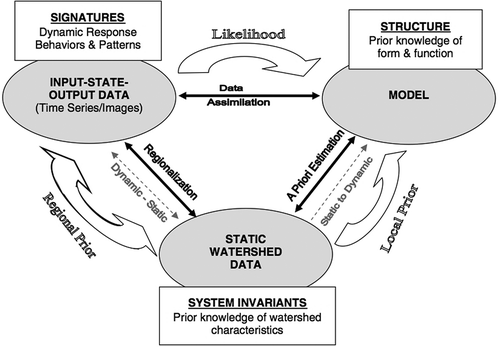
It is recognized that in many poorly gauged regions there is an almost complete lack of streamflow observation with which to undertake calibration and testing. For these regions, calibration and regionalization are simply not possible. However, in sparsely gauged regions there are streamflow measurements which can provide important information on catchment behaviour, and the interest is in increasing the value of these measurements for prediction in the adjacent ungauged catchments. A question related to that notion: Which observation data length is necessary to obtain adequate model parameterizations? was raised and investigated long before the PUB Decade (e.g. Ibbitt Citation1972, Sorooshian et al. Citation1983, Gupta and Sorooshian 1985, Yapo et al. 1998) and further explored by Xia et al. (Citation2004). It was concluded that different observation data lengths are necessary for different parameters to be determined adequately. In a detailed analysis, Vrugt et al. (Citation2006) showed that 2–3 years of streamflow data are sufficient to obtain robust parameter estimates for the SAC-SMA model. A similar result was obtained by Kuchment and Gelfan (Citation2009), who applied a distributed physically-based model for catchments located in the arid steppe and permafrost regions. However, Merz et al. (Citation2009) argued that more than 5 years of calibration period may be necessary to obtain stable parameter estimates in humid temperate climates. Other studies highlighted the potential of using only a few, well-chosen observations, preferably including unusual events to identify robust and stable parameterizations (Rojas-Serna et al. Citation2006, Seibert and Beven Citation2009, Singh and Bárdossy Citation2012). Perrin et al. (Citation2007) further pointed out that low complexity models need fewer data to constrain the feasible parameter space and that stable parameterizations are more problematic to obtain in catchments characterized by dry climate than in humid climates. In general it should be noted that the conclusions of the above studies need to be seen not only in terms of data quantity but also in terms of the quality of available data (see Beven and Westerberg Citation2011).
3.2.4 Advances in model uncertainty assessment
During the PUB Decade increasing awareness developed in the community that uncertainty analysis needs to take on a more prominent position in hydrology (Beven Citation2008). Comprehensive end-to-end uncertainty analysis (e.g. Pappenberger et al. Citation2005, Nester et al. Citation2012b) is instrumental in avoiding potential interpretative pitfalls, as it puts analysis results on a more robust scientific basis, while also allowing closer appraisal of the influence of different error sources on model quality (Dunn et al. Citation2008). Thus, in spite of a variety of common arguments against uncertainty assessment, as discussed by Pappenberger and Beven (Citation2006), not only should uncertainty analysis be an integral part of a scientific paper (Beven Citation2006b), but it should also be systematically implemented according to a general Code of Practice, rather than on an ad hoc basis (Pappenberger and Beven Citation2006, Wagener et al. Citation2006, Liu and Gupta Citation2007).
However, due to the inevitably difficult interpretation of “uncertain” results, strategies are necessary to unambiguously communicate such uncertain predictions to users and decision makers, as stressed by Beven (Citation2007). Likewise, others pointed out the need to better define, understand and communicate the basis of uncertainty (Montanari Citation2007, Todini and Mantovan Citation2007).
Although considerable progress has been made and the need for more rigorous uncertainty analysis is now widely accepted, there is on-going discussion about the most suitable techniques to use (Liu and Gupta Citation2007, Montanari et al. Citation2009), and on the consistency of the uncertainty bounds provided by different techniques. In the light of imperfect model structures, non-stationary errors in input data and the complex structure of model residuals, Beven and Freer (Citation2001b), as well as Beven (Citation2006b, 2006c, 2008), argued that the GLUE model (Beven and Binley Citation1992) is an effective uncertainty analysis technique. Due to subjectivity in the choice of behavioural models (Montanari Citation2005) and its use of non-formal likelihoods that are inconsistent with probability theory, GLUE is met with scepticism (Mantovan and Todini Citation2006, Todini and Mantovan Citation2007, Stedinger et al. Citation2008, Montanari et al. 2009, Clark et al. Citation2012), although, in further developments of GLUE, observational uncertainties are more explicitly taken into account to derive “limits of acceptability” and reduce subjectivity (e.g. Beven Citation2006c, Liu et al. Citation2009). Parts of the community thus consider Bayesian techniques to be more appropriate as formal statistical methods for uncertainty analysis (Kavetski et al. Citation2002, Vrugt et al. 2003, Schoups et al. Citation2010). In spite of methods reducing the non-stationarity of error structures and developments of advanced error models (Thyer et al. Citation2009, Schoups and Vrugt Citation2010), Beven et al. (Citation2008) argued that formal likelihood measures can be highly problematic, suggesting that even small deviations from the required assumptions can result in model over-conditioning and inadequate parameterizations. This can only be avoided if all sources of uncertainty can be treated as aleatory, i.e. random in nature (Westerberg et al. 2011b, Beven Citation2013), thus if the residuals converge towards the true prediction uncertainty distribution (Beven and Westerberg Citation2011). Treating non-stationary, epistemic uncertainties, i.e. errors due to lack of knowledge (Beven Citation2013) as aleatory will result in over-conditioning of posterior parameter distributions and thus underestimation of uncertainty, especially in the presence of disinformative data, strongly indicating the need to separate these two error types (Beven et al. Citation2011, Beven and Westerberg Citation2011, Beven Citation2013, Gong et al. Citation2013). Andréassian et al. (Citation2007), however, made the intriguing case that both uncertainty frameworks, i.e. GLUE and Bayesian methods, are potentially underestimating the scale of the problem.
Kuczera et al. (Citation2006) showed that lack of good prior information on the different sources of uncertainty creates an ill-posed problem, and that it is difficult to reliably disentangle the different sources of uncertainty, potentially resulting in disproportional effects on the modelled results (Kuczera et al. Citation2010). They concluded that the availability of a rainfall–runoff record alone is insufficient to disentangle the different sources of error. Subsequent work (Renard et al. Citation2010, Citation2011) suggests that disentangling different types of errors is more tractable when stronger independent, prior information, such as results of geostatistical analysis, is available. The importance of separating different sources of uncertainty was further underlined by Beven and Westerberg (Citation2011). Doubting the general information content of data, they argued that disinformation in data can introduce considerable and potentially long-lasting effects on model results and parameterizations, which could partly explain difficulties to adequately model certain catchments.
Although the combined importance of model structural, parameter and data errors are by now widely accepted in the community, decomposing the different sources of error has proven comparatively difficult, although a wealth of studies attempted to address the topic during the PUB Decade. In detailed analyses (e.g. Andréassian et al. Citation2001, Oudin et al. 2006a), it was shown that model performance and parameterization are highly sensitive to both random and systematic errors in precipitation data (e.g. Hrachowitz and Weiler Citation2011). These conclusions are supported by the results of Kavetski et al. (Citation2006a) and Renard et al. (2011) using the Bayesian Total Error Analysis (BATEA) tool and by Vrugt et al. (Citation2008) using the Differential Evolution Adaptive Metropolis (DREAM) algorithm. In spite of obtaining a better understanding of the effects of input error, it was also demonstrated that detailed insights into model structural errors are hampered by insufficiently specified error models (Kavetski et al. Citation2006a), which was later addressed by Renard et al. (2011). McMillan et al. (Citation2011b) further showed that multiplicative error formulation for precipitation based on lognormal distributions can approximate true error characteristics, albeit somewhat misrepresenting the distribution tails. Interestingly, and in contrast to precipitation, it was found that models are relatively insensitive to errors in potential evaporation series, most likely due to the buffering capacity of the soil moisture components and the related low-pass filter properties of models (Andréassian et al. Citation2004a, Oudin et al. Citation2004, Citation2005a, Citation2006a). It was nevertheless shown that the use of relatively simple temperature-based methods to estimate potential evaporation leads to somewhat better model performances than the use of the Penman approach (Oudin et al. Citation2005b).
Likewise, streamflow data can exhibit considerable uncertainties as a result of the combined influences of erroneous stage or velocity measurements, insufficient numbers of individual gaugings and changes in river cross-sections, leading to non-stationary stage–discharge relationships (e.g. Sorooshian and Gupta Citation1983, Di Baldassarre and Montanari Citation2009, McMillan et al. Citation2010, Westerberg et al. Citation2011a). In an attempt to consider the uncertainty in streamflow in models, for instance McMillan et al. (2010) proposed a method to generate a streamflow error distribution which can be used to form a likelihood measure for model calibration (see also Liu et al. 2009, Krueger et al. Citation2010). An example application of the method is shown in
Fig. 7 Example of a modelled hydrograph (90% confidence interval) based on calibration using (a) a deterministic rating curve and (b) a rating curve including uncertainty (from McMillan et al. 2010, © 2010 John Wiley and Sons, Ltd.). This result illustrates the effect of rating curve uncertainty, which may add uncertainty to model predicitions, especially for estimating extremes.
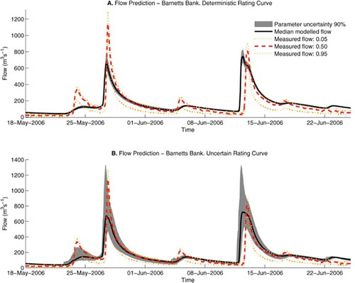
Different further approaches were introduced for an improved treatment of data, model structure and parameterization errors in model calibration. While Vrugt et al. (Citation2005) demonstrated the utility of combined global optimization and data assimilation for improved estimates of parameter and prediction uncertainty, Bárdossy and Singh (Citation2008) identified robust parameterizations based on an analysis of stochastically generated synthetic data errors. Various studies have presented methods to simultaneously and explicitly account for errors from different sources (e.g. Götzinger and Bárdossy Citation2008, Krueger et al. 2010). However, Gupta et al. (Citation2012) pointed out that model structural adequacy errors are of several types (perceptual, conceptual physical, conceptual process, spatial variability, equation and numerical) arising at different steps in the modelling process, and that a detailed study of these various causes is necessary to ultimately address issues of learning by the process of confronting models with data (Gupta et al. Citation2008, see also Section 3.2.5). However, as emphasized by Kumar (Citation2011) and Wagener and Montanari (2011), additional challenges for predictability that are not yet well understood arise, for example, from dynamic changes in the spatial complexity of the system. Offering an alternative approach to treating uncertainty, Montanari and Koutsoyiannis (Citation2012) stochastically perturbed data, model parameters and output in a multi-model approach, accepting that “uncertainty is an intrinsic property of nature, and that causality implies dependence of natural processes in time” (Koutsoyiannis Citation2010), which in principle implies a predictable system. Pursuing this argument, even small uncertainties, e.g. in the initial conditions, may result in unpredictability. It is thus desirable and possible to “shape a consistent stochastic representation of natural processes, in which predictability (suggested by deterministic laws) and unpredicitability (randomness) coexist and are not separable or additive components” (Koutsoyiannis Citation2010).
A further aspect of uncertainty was pointed out by Kavetski et al. (Citation2006b), who argued that problems related to calibration, such as complex structures on objective function response surfaces, are not necessarily characteristics of models themselves, but rather are partly artefacts arising from inappropriate numerical implementation. In other words, in the absence of analytical solutions for the partial differential equations featuring most hydrological models, numerical approximations can result in inconsistent and biased model parameterizations. In detailed analyses, it was shown that commonly applied fixed-step explicit methods are unsuitable for use in hydrological models, and the community was encouraged to reconsider this aspect and call for more appropriate techniques, such as adaptive time stepping or implicit methods (Clark and Kavetski Citation2010, Kavetski and Clark Citation2010, Schoups et al. 2010). Similarly, low temporal data resolution may not only lead to the identification of unsuitable model structures (e.g. Arnaud et al. Citation2002, Zehe et al. Citation2005, Michel et al. Citation2006), but can also cause spurious parameter estimates (Hrachowitz et al. 2011a, Kavetski et al. Citation2011). This issue can only partly be solved by robust numerics. Where, for example, there is a mismatch between the information content of input data, output data and information used in the model, methods of interval arithmetic can help to provide more robust parameter estimates (Van Nooijen and Kolechkina Citation2012).
Notwithstanding the significant advances in model uncertainty assessment discussed above, Wagener and Montanari (Citation2011) pointed out that the focus needs to shift from reducing model uncertainty towards reducing the uncertainty in our understanding of how catchments function under given environmental boundary conditions, as this holds the key to developing more reliable predictions in ungauged basins. This critical point of linking catchment form to hydrological function in order to reduce predictive uncertainty in ungauged basins largely depends on knowledge synthesis via comparative hydrology. In other words, rather than constraining model structural and parameter prior distributions, based on some knowledge of the system (see Section 3.3.1), it can prove valuable to infer information on the functioning of an ungauged catchment, for example, in the form of regionalized hydrological signatures (i.e. metrics describing different response characteristics of a catchment, such as the flow duration curve) and to train the model in the ungauged catchment to reproduce these signatures. Thereby, the feasible model and parameter spaces can be constrained and estimates for predictive uncertainty can be derived from the ensemble of retained behavioural models. This approach was successfully adopted by several authors. Yadav et al. (2007) regionalized the slope of the flow duration curve, high pulse counts and baseflow index, including their respective prediction limits on the basis of regression models. By forcing models to reproduce these signatures so as to fall within the respective prediction bands, they were able to significantly constrain the feasible parameter space and thereby reduce the predictive uncertainty of their models. This approach was refined by Zhang et al. (Citation2008), who introduced a multi-objective framework to identify feasible parameterizations for ungauged basins. In a somewhat different vein, not relying on regionalized information, but rather on scarce information on the catchment of interest itself, Winsemius et al. (2009) were able to constrain the prior parameter distributions and to narrow prediction intervals by discarding parameterizations that could not reproduce the estimated shape of the recession, the spectral properties and the monthly water balance (). Other examples for similarly deriving constrained posterior distributions and reducing predictive uncertainty in ungauged basins include the use of the baseflow index estimated from soil types (Bulygina et al. Citation2009, Citation2011), satellite observations of flood extent (Di Baldassarre et al. Citation2009), and the use of parameter libraries derived from model parameterizations of a large set of gauged catchments (Perrin et al. Citation2008, Kuchment and Gelfan 2009).
Fig. 8 The 5% and 95% plausibility intervals of output based on posterior parameter distributions with multiple constraints (recession slope, spectral properties, monthly water balance): discharge (top) and evaporation (bottom, from Winsemius et al. 2009, © 2009 John Wiley and Sons, Ltd.). This example illustrates the potential value of applying constraints based on “soft” data and emergent properties, to reduce predictive uncertainty especially for predictions in data-scarce regions.
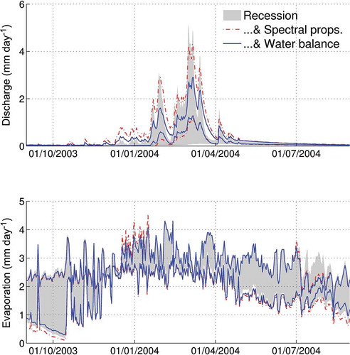
A more holistic approach of comparative uncertainty quantification has been adopted by Blöschl et al. (2013). Predictive uncertainty was estimated by the cross-validation performance of the prediction of runoff signatures, in the form of blind testing. This comparative assessment is a way of assessing predictions and estimating model uncertainty through an ensemble of predictions in different places (Andréassian et al. Citation2006). It includes all sources of uncertainty, such as input data, model structure and parameters (Wagener and Montanari Citation2011). In contrast to traditional approaches, there is no error propagation involved. Instead, cross-validation performance is used as an estimator of total uncertainty. One of the generic findings of a comparative analysis of 25 000 catchments around the world was that uncertainty tends to increase with aridity and decrease with catchment scale. The comparative framework therefore facilitated pattern identification, and holds a lot of promise for complementing traditional uncertainty approaches, as well as for harmonizing hydrological research in both gauged and ungauged basins.
3.2.5 The potential of models as learning tools
In the light of advances in model design and uncertainty analysis, the potential of models to teach us more about the system can and should be thoroughly exploited by using models as learning tools, as stressed by Beven (Citation2007) and Dunn et al. (2008). This refers to testing different model structures and treating them as multiple working hypotheses, for a given catchment (e.g. Clark et al. Citation2011b). Rigorous model testing can then not only reveal model weaknesses but, in a feedback process, can also inform the modeller as to which parts of the hydrograph are not well reproduced by a given model (Savenije Citation2009), thereby guiding model improvement and resulting in better process understanding (Kavetski and Fenicia Citation2011, Martina et al. Citation2011, McMillan et al. Citation2011a, Fenicia et al. 2013). For example, Reusser et al. (Citation2009) used a data-reduction method based on self-organizing maps to identify the timing of different dominant error types, which can inform the modeller about model structural errors. In a quite different approach, Bulygina and Gupta (Citation2009, Citation2010, Citation2011) demonstrated the utility of Bayesian data assimilation as a strategy for detecting, diagnosing and correcting model structural errors. Analysing and evaluating models for periods of high information content and, thus, the typically non-stationary identifiability of individual parameters (Wagener et al. 2003, Wagener and Kollat Citation2007, Reusser et al. Citation2011) is also an extremely valuable task for learning more about the system and the impact of change on the system (e.g. Buytaert and Beven Citation2009, Citation2011, Merz et al. Citation2011).
Arguing that current model testing strategies are largely inadequate and that much more information could be extracted from data and models, Gupta et al. (Citation2008) proposed a robust evaluation scheme based on hydrological signatures. Such an evaluation scheme would allow a more comprehensive assessment of different relevant system dynamics and thus enable us to use models to increase our knowledge and to enhance our perception of the system. Similarly, Euser et al. (Citation2013) designed a framework that allows a multi-dimensional evaluation of different model hypotheses based on a range of hydrograph signatures.
The notion of models as learning tools can be extended by assuming that a given, well-tested model is a suitable representation of real-world processes. In fact, such a model can be used not only to infer the importance of different processes and boundary conditions in a given catchment (e.g. Gelfan et al. Citation2004, Grimaldi et al. 2010, Nippgen et al. Citation2011), but also, in a much broader sense, to serve as a virtual reality for experiments, from which, in turn, response patterns and internal system dynamics, as well as their sensitivity to changing boundary conditions and climatic forcing, can be explored and compared. Bashford et al. (Citation2002), as well as Weiler and McDonnell (Citation2004), for example, sought to understand the value of different data and to improve process conceptualizations with virtual experiment approaches. In a subsequent paper, Weiler and McDonnell (2006) demonstrated the utility of virtual experiments to quantify first-order controls, such as drainable porosity and soil depth variability, on nutrient transport. Dunn et al. (Citation2007) used the concept to learn more about how catchment boundary conditions, such as mixing storage, influence water mean residence time, while Hrachowitz et al. (2013) used models in a virtual experiment approach to track water and tracers through the system in order to analyse the climatic controls on the dynamics of water age distributions. Their main finding was that water age distributions depend on model complexity as well as on mixing mechanisms, and they can exhibit substantial hysteresis effects, reflecting antecedent conditions. In a somewhat contrasting application of the virtual experiment concept, Kling and Gupta (Citation2009) evaluated the effect of insufficient representation of spatial variability in a catchment on the optimal parameter values. They found that, when ignored in a model representation, spatial variability of physical catchment characteristics can generate considerable noise in the parameter estimates, depending on model complexity and parameter interactions.
Models, however, can also serve as valuable learning tools in ungauged catchments, when combining regionalized information of catchment function or our expectation of the catchment behaviour, i.e. hydrological signatures, with model priors, i.e. the model’s uncertain prediction of the catchment behaviour, as emphasized by Wagener and Montanari (Citation2011) and demonstrated by a comparative modelling study in an artificial catchment (Holländer et al. 2009). In other words, by constraining the parameter and model spaces with some metric of expected catchment behaviour, unfeasible representations of reality can be identified and discarded, thereby allowing the modeller, in a feedback process, to better understand the way a catchment functions. Ways to infer the expected behaviour of ungauged catchments are, for example, to regionalize specific hydrological signatures (see Section 3.3.1, e.g. Castellarin et al. Citation2004, Yadav et al. 2007, Bulygina et al. Citation2009, Pallard et al. Citation2009), or to use combinations of quantitative and qualitative information to derive limits of acceptability on specific signatures (e.g. Winsemius et al. 2009).
In addition to the benefits of using models as learning tools discussed above, this approach is crucial for guiding and improving experimental design to maximize the information to be gained from data. These examples highlight the potential of models as learning tools, an approach that is far from being exhaustively exploited and which may prove highly valuable for many future applications.
3.3 Catchment classification and new theory
Hydrological sciences are characterized by substantial process heterogeneity across places as well as spatial and temporal scales. For a long time this heterogeneity has impeded attempts to deepen our understanding of what controls hydrological processes and how they are linked. Yet, only from insights into the effects of these heterogeneities on response patterns, in other words, from a synthesis of process understanding, i.e. assembling individual pieces of information to search for an unknown pattern, valid across multiple spatial and temporal scales (see Thompson et al. 2011a), can a holistic theory of hydrology emerge (Sivapalan Citation2005, Blöschl Citation2006). The identification of scaling relationships, as well as the development of catchment classification schemes and similarity frameworks, based on comparative studies can be seen as a promising way forward towards synthesis (McDonnell and Woods Citation2004). Such a comparative approach was adopted in the PUB synthesis book (Blöschl et al. 2013) to organize the diversity of knowledge about runoff prediction. The approach sheds light on co-evolutionary processes of climate, geology, topography and ecology to understand catchments as complex systems (e.g. Gaál et al. 2012). Process relationships and generalizations can therefore be inferred, even for conditions and scales for which rigorous mechanistic models are not yet formulated.
3.3.1 Advances in process and parameter regionalization
It is probably fair to say that scientific hydrology was highly fragmented at the beginning of the PUB Decade. It was soon realized that linking the results of individual process studies and designing designated comparative process and modelling studies (e.g. Andréassian et al. 2006, Carey et al. Citation2010) would prove highly instructive in exploring the overall patterns driving hydrological response, eventually facilitating process regionalization. This was one of the core objectives of the PUB initiative, as regionalization is instrumental for assessing and predicting hydrological response in ungauged catchments. Comparative studies were instrumental in identifying robust ways for regionalizing process knowledge. In general terms, regionalization efforts can be classified as (He et al. Citation2011): (a) direct regionalization of flow and flow metrics, and (b) regionalization of model parameters, both of which are based on either regression methods, or some kind of distance measures between gauged and ungauged sites.
Relatively simple regression approaches have already shown some value for determining first-order controls on catchment function in data-scarce regions. For example, in attempts to formulate parsimonious expressions for estimating mean annual flow, baseflow index and other flow metrics for data-scarce areas in Africa, Mazvimavi et al. (Citation2004, Citation2005) compared 52 catchments, concluding that mean annual precipitation, land cover, mean catchment slope and drainage density are important controls on flow. Cheng et al. (Citation2012), on the other hand, identified the baseflow index, a proxy for the combined influence of geology, soils, topography, vegetation and climate, as the dominant control on the shape of flow duration curves. Investigating flood frequency in 44 catchments, Pallard et al. (Citation2009) were able to show the influence of drainage density. The influence of different landscape elements, characterized by distinct dominant processes, on functional patterns was demonstrated by Lyon et al. (Citation2012) in a study based on 80 nested sub-catchments. As highlighted by Marechal and Holman (Citation2005) in a simple regression approach, the British Hydrology Of Soil Types scheme (HOST), for example, is very robust for predicting the baseflow index, low flow statistics and the standard percentage runoff based entirely on soil map data. Other studies were able to establish similar links between stream chemistry and different flow paths (e.g. Laudon et al. Citation2007, Soulsby et al. Citation2007, Harpold et al. Citation2010), or climate (e.g. Dawson et al. Citation2011, Laudon et al. Citation2012).
Based on more complex regression models, low flows were regionalized with the use of a variety of seasonality indices, revealing the benefits of customizing regression models to regional requirements, rather than using global models (Laaha and Blöschl Citation2006a). In a subsequent analysis (Laaha and Blöschl Citation2006b), it was shown that regression models based on catchments grouped according to seasonality provide highly robust regionalization results. In a further example, applying a strong regional relationship with physical catchment characteristics, Soulsby et al. (Citation2010b) were able to predict mean transit times, while, in a rather different type of study, they successfully used regression models to estimate flow metrics as a function of catchment mean transit time (Soulsby et al. Citation2010a).
Similarly, geostatistical methods have proven valuable for estimating hydrological variables in ungauged catchments. Skøien and Blöschl (Citation2007), for instance, developed the topological kriging technique (or top-kriging), which accounts for hydrodynamic and geomorphical dispersion. Their results indicate that this technique can not only outperform deterministic runoff models in regions where stream gauge density is sufficiently high, as it avoids problems with input data errors and parameter identifiability, but also provides more robust estimates than regional regression models (Laaha et al. Citation2013). Comparison of top-kriging with Physiographical-Space Based Interpolation (PSBI) highlights the complementary utility of the two methods for headwater and larger-scale catchments (Castiglioni et al. Citation2011).
However, it is increasingly acknowledged that spatial, proximity does not necessarily entail similarity in functional behaviour (e.g. Ali et al. Citation2012), and that the efficiency of distance-based approaches can be considerably improved when applying some sort of hydrologically more meaningful distance measure (Bárdossy et al. Citation2005, He et al. Citation2011). For example, Merz et al. (Citation2008) combined the top-kriging method with catchment characteristics to enhance the predictive performance of the method. An alternative method to assess functional similarity was introduced by Archfield and Vogel (Citation2010). Instead of using the spatially closest stream gauge as reference for transferring daily flow to an ungauged site, they proposed the kriging-based map-correlation method, which selects the reference stream gauge whose flows are most correlated to the ungauged site. Likewise, pursuing the search for hydrologically more meaningful dissimilarity measures for predicting flow, Samaniego et al. (Citation2010a) suggested the use of pair-wise empirical copula densities. For the prediction of long-term flow duration curves, Castellarin et al. (Citation2007) tested and confirmed the utility of a stochastic index-flow model, while Castellarin (Citation2007) demonstrated the use of probabilistic envelope curves for determining plausible extreme flood values in ungauged catchments.
In contrast to the regionalization of flow metrics, regionalization efforts for transferring model parameterizations from gauged to ungauged catchments have a longer tradition (see Wagener et al. 2004), despite the additional uncertainty introduced by input data and model structural errors, as well as the need for parameter calibration at the gauged sites (Wagener and Wheater Citation2006, He et al. Citation2011). Extrapolating their model parameters, Dunn and Lilly (Citation2001) were among the first to explore the potential of parameter regionalization based on the HOST classification. In a subsequent comparative study, it was demonstrated that models run with HOST-derived parameter sets performed as well as independently calibrated models (Soulsby and Dunn Citation2003). In a similar way, a range of studies demonstrated the potential of soil data to guide a priori parameterizations of the SAC-SMA model, valuable for parameter regionalization with limited need for calibration (e.g. Koren et al. Citation2003, Smith et al. Citation2004, Anderson et al. Citation2006), thus underlining the value of hydrologically meaningful soil classification schemes (e.g. Boorman et al. Citation1995, Schneider et al. Citation2007). Other studies emphasized the value of parameter regionalization methods based on either physiographic similarity, as a proxy for functional similarity (Arheimer and Brandt Citation1998, Parajka et al. Citation2005, Dornes et al. 2008b, Masih et al. Citation2010), or spatial correlation, where gauge density is sufficiently high (Merz and Blöschl Citation2004, Oudin et al. 2008a). gives an example of such clear spatial patterns of calibrated parameters in a densely gauged region. Further, Parajka et al. (Citation2007a) demonstrated that simultaneous calibration of model parameters (regional calibration) can be beneficial for runoff simulation in ungauged catchments. In fact, one of the strengths of the regional calibration method is to reduce the uncertainty of the estimated parameters. Extending the use of transfer functions and imposing conditions of monotony and uniform continuity on model parameters during calibration proved to be a significant improvement, as it resulted not only in adequate model performances but also in more consistent regression relationships (Götzinger and Bárdossy Citation2007). It was, however, also pointed out that the presence of equifinality in calibrated parameters limits the use of the methods discussed above for extrapolating individual parameters and that, instead, complete parameter sets should be transferred to ungauged sites (Bárdossy Citation2007). Addressing the issue of scale dependency of parameters, Samaniego et al. (Citation2010b) proposed an elegant multi-scale parameter regionalization method to link finer resolution of input data to the coarser scale at which dominant processes are active. Similarly, step-wise methods have been proposed for simultaneous multi-basin calibration, including first headwaters of similar physiographic character, then river reaches and finally lakes to find robust parameters across large regions (Arheimer and Brandt Citation1998, Donnelly et al. Citation2009, Arheimer et al. 2012, Strömqvist et al. 2012).
Fig. 9 Spatial patterns of selected calibrated model parameters—top: maximum soil moisture storage FC (mm); centre: potential evaporation limit LP (mm); and bottom: nonlinearity parameter β (-)—for the calibration periods 1987–1997 (left) and 1976–1986 (right) (from Merz and Blöschl 2004, © 2004 Elsevier). This illustrates the potential of using spatial proximity as a proxy for functional proximity in densely gauged regions.
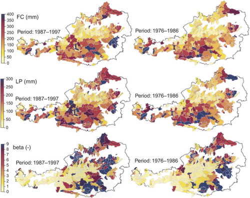
An alternative to parameter regionalization based on calibrated parameter sets at gauged sites is the use of direct a priori parameter estimation from measurable catchment physical property data (Hughes and Kapangaziwiri Citation2007). Kapangaziwiri et al. (Citation2009, 2012) investigated the use of such methods, incorporating uncertainty, and compared the model outputs with uncertain regional signatures of catchment runoff response and groundwater recharge estimates. They found that there was little consistency in the results and, in some cases, the uncertain parameter estimates generated narrower uncertainty bounds than the regional signatures. However, Fang et al. (2010) demonstrated that the performance of a physically-based hydrological model using a priori parameters derived from a LiDAR DEM for an agricultural catchment was close to the that of a calibrated model, and that it was a good approach where detailed DEMs are available for ungauged catchments. Dornes et al. (2008b) emphasized that physically measurable parameters could be transferred thousands of kilometres if physically-based models were used and the ecohydrological similarity of catchment function could be assured. In a more recent study, Fang et al. (Citation2013) have shown that appropriately structured flexible, physically-based models with a priori parameter estimation from measurements on site, or in similar conditions, can provide robust estimation of snowpack, soil moisture and streamflow at multiple scales, and that falsification of the model (CRHM) from appropriate structures leads to substantial model failure despite the use of measured parameters.
In a cross-over approach, Yadav et al. (2007) regionalized dynamic response characteristics of catchments based on physical characteristics. They subsequently used the extrapolated flow metrics to constrain model parameterizations at ungauged sites, thereby avoiding problems of model structural and parameter calibration errors. Blöschl et al. (2013) summarized how remotely sensed data, such as evaporation, soil moisture and snow patterns, can serve to constrain regionalized model parameterizations at ungauged sites. Notwithstanding the advances discussed, Oudin et al. (Citation2010) pointed out that the frequent assumption of close correspondence between physical and functional similarity of catchments may be invalid in many catchments.
3.3.2 Advances in catchment classification and similarity frameworks
A further important step towards the formulation of a holistic hydrological theory is the design of a generally accepted catchment classification framework, based on similarity of hydrological function, thereby providing a means to assess the dominant controls on patterns of water movement in catchments (McDonnell and Woods Citation2004). As discussed by Wagener et al. (2007), the ultimate goal of classification is to understand how catchment structure, climate and catchment function (i.e. response pattern) interact. Different types of classification are already in use, but fall short of providing a comprehensive picture of hydrological response patterns and causes of similarities between catchments. An effective classification scheme should thus be characterized by the ability to identify the ensemble of dominant factors causing the hydrological behaviour of a catchment, thereby combining “form”, i.e. the boundary conditions or structure of the system, and forcing, i.e. climate characteristics (see Winter Citation2001). Ideally, such a classification scheme should be strongly underpinned by the basic functions of a catchment, such as mechanisms of water partitioning, storage, release and transmission within the catchment, potentially to be quantified by different catchment signatures, as suggested by Wagener et al. (2007).
A promising research avenue explored during the PUB Decade was the utility of catchment structure as a first step towards comprehensive classification schemes. One possible method is based on the assumption that the catchment structure should ideally be reflected in structures of catchment models (Fenicia et al. 2013). Identifying the most adequate model structure for a catchment from a suite of multiple competing model hypotheses (e.g. Clark et al. 2011a) can be seen as a robust first-order classification method, as demonstrated in a study involving around 200 catchments (Ye et al. 2012, ). In an alternative approach, building on seminal work by Horton (Citation1945), Strahler (Citation1957) and Rodriguez-Iturbe and Rinaldo (Citation1997) characterizing landscapes with the help of dimensionless numbers, Berne et al. (Citation2005) were able to demonstrate the potential of dimensionless hillslope Peclet numbers to relate form, hydraulic properties and climate to hydrological response patterns. Lyon and Troch (Citation2007, Citation2010) corroborated their conclusions by finding a good correspondence between analytically derived and observed moments of subsurface response function as defined by hillslope Peclet numbers. Likewise, Harman and Sivapalan (Citation2009) demonstrated a link between storage–release dynamics, boundary conditions and characteristic storage thickness. Including the concept of hydrological regimes, they argued that such a similarity framework can be used to classify hillslopes according to their subsurface flow dynamics.
Fig. 10 Based on analysis of flow duration and regime curves, and the inferred influence of temperature, aridity, seasonality and phenology, the circled areas represent regions of process similarity. This indicates the need for models that represent the same dominant processes for catchments within the circled regions (from Ye et al. 2012)—an example of how careful synthesis of catchment emergent properties and signatures can guide the model design and selection process for data-scarce regions in particular.
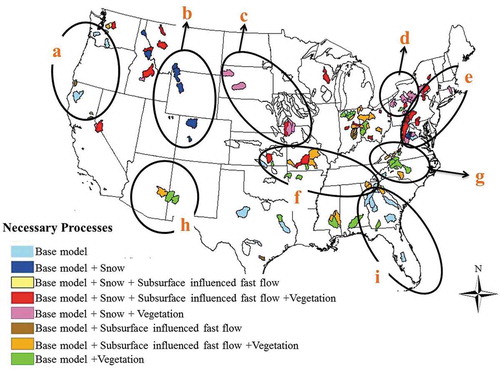
In contrast, Woods (Citation2003) developed models to predict differences between catchments based on dimensionless similarity parameters representing different aspects of topography, soil, vegetation and climate. Viglione et al. (Citation2010) introduced similarity parameters for characterizing the space–time variability of flood processes. Accounting for the relative roles of network connectivity, hydraulic gradients and flow portioning between lateral and vertical flow paths within a given hydro-climatic region, Buttle (Citation2006) introduced the T3-template, a classification framework reflecting the relationships between portioning, transmission and release dynamic. However, as noted by Blöschl (Citation2005), similarity measures differ in terms of the processes they aim to represent, and a reasonable choice of the measures depends on the understanding of the dominant runoff generation mechanism in both gauged and ungauged catchments. Kuchment and Gelfan (2009), for example, found that the dimensionless indexes derived from the Richards equation, i.e. Peclet number and capillary filtration efficiency, work well as similarity measures for the arid steppe region where the infiltration excess mechanism of runoff generation dominates.
Classification schemes based on hydro-climatic factors largely relate to the Budyko curve, plotting the catchment aridity index, i.e. the ratio of average annual potential evaporation over average annual precipitation, against the ratio of average annual actual evaporation over average annual precipitation (Budyko Citation1974). The Budyko curve thereby interprets the annual water balance as a manifestation of the competition between available water and available energy, as underlined by Sivapalan et al. (Citation2011b). In spite of ambiguous interpretation possibilities (Andréassian and Perrin Citation2012), it can be seen as a simple tool for obtaining a first-order functional classification of catchments, as demonstrated, for example, by Tekleab et al. (Citation2011). Building on the Budyko curve and extending the functional approaches of L’vovich (Citation1979) and Ponce and Shetty (Citation1995) to allow for analysis of regional and inter-annual variability in quick flow, slow flow and evaporation, Sivapalan et al. (2011b) were able to identify non-dimensional similarity metrics that can link regional to site-specific patterns, thus indicating a universal underlying relationship. Parajka et al. (Citation2009b, Citation2010) pointed out the value of the seasonality of hydrological variables for inferring catchment similarity. Seasonality, along with catchment state and spatial coherence, was used by Merz and Blöschl (Citation2003) to classify floods into types by their generating mechanisms such as synoptic floods, flash floods, snowmelt floods and rain-on-snow floods.
In a different approach, DiPrinzio et al. (Citation2011) used self-organizing maps to classify around 300 catchments according to climate, structural and functional descriptors, while Sawicz et al. (2011), applying cluster analysis based on six functional signatures, such as the runoff coefficients and the slope of the flow duration curves, were able to classify around 300 catchments into nine clusters. Similarly, using four similarity metrics—the aridity index, the seasonality index, day of peak precipitation and day of peak runoff—it was shown that more than 300 catchments can be classified into only six classes (Coopersmith et al. Citation2012). In spite of within-class variability, this allows the determination of first-order differences in hydrological function between catchments. In an effort to synthesize the results of three of the studies discussed above (i.e. Cheng et al. 2012, Coopersmith et al. 2012, Ye et al. 2012), Yaeger et al. (Citation2012) highlighted that climate seasonality and aridity were dominant controls on the regime curve of monthly mean flows, and were connected to the central slope of the flow duration curve. From that it could, in turn, be reasoned that the middle part of the flow duration curves, describing the average catchment response, is characterized by climate. In contrast, the low-flow ends of the flow duration curve were shown to be dominated by catchment characteristics, e.g. soils. This study illustrated the value of synthesis as structural and climatic controls, obtained from different approaches, could be combined to regionalize hydrological function (or model structures), thus marking a crucial step towards a unified classification framework.
3.3.3 Advances towards a new hydrological theory
During the PUB Decade, an increasing understanding emerged that the hydrological system cannot be sufficiently well understood by focusing on the hydrograph alone (see Gupta et al. Citation2008). Given the importance of evaporative processes as the largest flux of both mass and energy in the system in many regions of the world, it was realized early that the dynamics and patterns of these processes need to undergo closer scrutiny (e.g. Brutsaert Citation1986, Gan and Burges Citation1990b, Grayson and Blöschl Citation2000). Therefore, a variety of studies started to more closely investigate evaporative processes, and to establish stronger links with our perception of the hydrological cycle at multiple scales from processes at the plant cell scale to organizational patterns at the global scale (e.g. Gerten et al. Citation2004, Savenije Citation2004, de Groen and Savenije Citation2006, Green et al. Citation2006, Siqueira et al. Citation2006, Teuling et al. Citation2006, Gerrits et al. Citation2009, Citation2010, Mahecha et al. Citation2010, Seneviratne et al. 2010, Van der Ent et al. Citation2010). For example, Thompson et al. (Citation2011b) emphasized the combined roles of soils, temperature, as well as rainfall phase and seasonality, on seasonal dynamics of evaporation. Moreover, Troch et al. (Citation2009b) were able to show, in a compelling study, that with decreasing water availability, water use of vegetation becomes more efficient and, independently from the boundary conditions, vegetation adapts to climate in similar ways. Similarly, the establishment of stronger links between hydrology, climate, vegetation and nutrient transport dynamics (e.g. Arnold et al. Citation1998, Dawson et al. Citation2002, Citation2008, Johnson et al. Citation2006, Citation2007, Abbaspour et al. Citation2007, Pacific et al. Citation2009) will be a promising way forward.
Results like these helped to acknowledge the importance of coupling hydrology, climate, soils and vegetation, and underpinned the need to widen our traditional concept of the water cycle to reflect a real systems approach. This was strongly emphasized by Kumar (Citation2007), who argued that the property of the water cycle as a network of innumerable, self-organizing, dissipative feedback cycles must be more explicitly addressed. From there, it was only a small step to recognize the need to identify universal organizing principles, evolving from fundamental physical or biological laws, and to integrate the processes involved in the co-evolution of climate, soils, topography, vegetation and humans, ultimately leading the way to new, promising modelling strategies which could potentially include what were termed behavioural modelling approaches (Schaefli et al. Citation2011).
Following the co-evolution of the landscape with hydrology, vegetation—in a continuous feedback process—adapts to and shapes the hydrological system (e.g. Horton Citation1933, Savenije Citation2010). Thus, from a vast range of potential organizing principles (Paik and Kumar Citation2010), the set of ecological optimality hypotheses postulated by Eagleson (Citation1978) is a promising candidate for a hydrologically meaningful organizational principle. Eagleson (Citation1978) invoked three constraints on the state of vegetation, as discussed and reformulated by Sivapalan (Citation2005): (a) over short time scales the vegetation canopy density is in equilibrium with climate and soil to minimize water stress of vegetation and to maximize equilibrium soil moisture; (b) over long time scales species will be selected whose transpiration efficiency maximizes equilibrium soil moisture equivalent to minimizing total evaporation; and (c) over very long time scales vegetation will alter soil properties and pore disconnectedness to maximize optimal canopy density. As underlined by Sivapalan (Citation2005), possible combinations of climate–soil–vegetation systems can then be limited to relatively small subsets satisfying these three optimality constraints. In addition, the optimality approach could potentially facilitate predictions at any scale of interest, reducing the required model complexity and largely diminishing the need for calibration, thereby providing falsifiable models (Schymanski Citation2008). As an example, Schymanski et al. (Citation2008, Citation2009) constrained plant transpiration, canopy cover pattern, CO2 dynamics, root water uptake and rooting depth by maximizing net carbon profit, illustrating the effectiveness of optimality-based modelling when combining mechanistic approaches of water movement through the soil with evolutionary concepts accounting for plant functioning and adaption to the environment (Sivapalan Citation2009). As illustrated in , an optimality-based model could reproduce the main features of daily evapotranspiration rates and CO2 assimilation observations, indicating that optimality may be a useful way of approaching prediction and estimation of vegetation cover, rooting depth and fluxes in ungauged basins without the need for calibration.
Fig. 11 Modelled (black) and observed (grey) daily (a) evapotranspiration rates (ET) and (b) net CO2 assimilation rates (Ag,tot). The means of the observed and modelled time series are given, together with the mean absolute errors (MAE) and Pearson’s r values, indicating the goodness of fit (from Schymanski et al. 2009, © 2009 John Wiley and Sons, Ltd.).
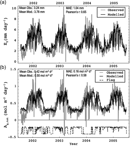
Viewing hydrological systems as open, dissipative systems far from equilibrium and treating them in a thermodynamic framework offers new ways to explain catchment structure, formulate general constraints on their dynamics and their evolution in time (see Kleidon and Schymanksi Citation2008, Kleidon et al. Citation2010). Thermodynamics forms a common framework to describe stocks, fluxes, conversion and dissipation of energy. Apart from conservation of mass, it emphasizes conservation of energy (the first law of thermodynamics) and explains the direction of spontaneous processes from first principles (the second law of thermodynamics). Potential advantages of a thermodynamic approach are that (a) energy expressed as conjugate variables provides the link between energy and system states for any process, (b) by adding energy considerations in the centre of hydrological dynamics, additional system constraints based on additional observables can be formulated, (c) the second law provides a direction for system evolution, which deterministic physics does not, and (d) it allows one to formulate and evaluate general optimality hypotheses such as Maximum Entropy production (MEP): Wang and Bras (Citation2011) proposed a model of evaporation over soils of variable wetness based on MEP; Porada et al. (Citation2011) applied the same principle to estimate parameters related to root water uptake and runoff production in a global water balance model. The parameter values that maximize global entropy production also lead to reasonable reproduction of observed large river basin runoff. Schymanski et al. (Citation2010) also applied MEP to predict the effect of heterogeneous vegetation cover on water fluxes and biomass. Zehe et al. (Citation2010) applied the principle of Maximum Energy Dissipation to model preferential flow in soils, while Kleidon et al. (Citation2013) investigated how systems with processes coupled by feedbacks evolve towards states of maximum power.
It is not yet entirely clear whether the optimality principle also applies at the time scales of the hydrological response and, if so, which optimality constraints apply, or how short-term changes of the system can be accommodated while at the same time making the most efficient use of available data. However, it may be seen that a careful synthesis of mechanistic or Newtonian approaches, describing how energy as well as mass fluxes defined by the boundary conditions of the system, and evolutionary or Darwinian approaches, characterizing patterns of variability (e.g. Kumar and Rudell Citation2010), has the potential, within the framework of comparative hydrology (Blöschl et al. 2013), to become valuable for achieving a deeper understanding of hydrological systems and of how they will evolve over time (Blöschl and Montanari Citation2010, Sivapalan et al. Citation2011a), possibly in the direction of a new holistic theory of hydrology.
4 HOW DID PUB EVOLVE OVER THE DECADE?
The PUB science plan (Sivapalan et al. 2003b) was the official document guiding the development of the PUB initiative and providing a starting point at the beginning of the PUB Decade. The initial science focus centred on the reduction of predictive uncertainty and evaluating the consequences of inadequate knowledge and its influence on uncertainty. Five broad community objectives for PUB were defined:
to develop an extensive observational field programme in research watersheds across the world;
to increase awareness of the value of data and the need for targeted gauging of currently inadequate data sources;
to advance capability to make predictions in ungauged basins based on local knowledge;
to advance the understanding of the links between climate, landscape and hydrological processes; and
to promote capacity building.
These objectives, centred around the quest to reduce predictive uncertainty, were to be addressed by six specific PUB science questions:
What are the gaps of knowledge?
What are the requirements to reduce uncertainty?
What experimentation is needed?
How can observational technologies be used to improve predictions?
How can process descriptions be improved to reduce uncertainty? and
How can the value of data be maximized?
The science questions were investigated from different perspectives, as highlighted by the six parallel science themes (see Section 2), in an attempt to reach the actual targets of PUB, i.e. improving existing and developing new models based on improved process understanding with reduced need for calibration, which were conceived to be the necessary steps forward at that time. The way scientific understanding evolved and thinking shifted towards new questions during the PUB Decade is sketched in and outlined briefly below.
Fig. 12 Outline of how scientific understanding evolved and the way of thinking shifted towards new questions during the PUB Decade.
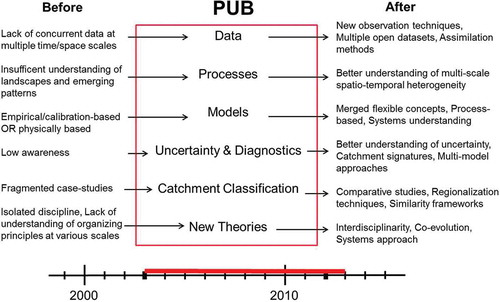
Within the context of PUB, the emphasis on data was seen as offering the opportunity to develop a better understanding of patterns and dynamics of the underlying processes in both gauged and ungauged catchments in order to pursue the goal of reducing the predictive uncertainty in these catchments. Besides advances in observation technology (see Sections 3.1.1 and 3.1.2), considerable efforts were thus made to ensure the availability of a wide spectrum of hydrological and water quality data from existing or new experimental catchments (see Sections 3.1.3–3.1.5). In spite of sometimes considerable uncertainties associated with data, a major stepping stone towards an improved understanding and characterization of process heterogeneity was the understanding of the value of pooling data from catchments in contrasting environmental settings for comparative studies, thus explicitly investigating the links between process heterogeneity and climate, vegetation and geology. Data analysis also allowed the evaluation of different types of data, thus feeding back into data acquisition by guiding targeted future observations necessary for an improved understanding.
It was gradually realized that many existing model concepts, although sometimes applied out of context, were not unreasonable representations of the dominant processes underlying the catchment response. This is reflected in the continued use of many “old” models and only a limited number of significantly different, new model formulations (see Sections 3.2.1 and 3.3.3). However, important progress was made in actually better understanding these models and the interactions between their parameters. This led to more targeted applications of different models at different locations, and endorsed the use of explicitly flexible modelling strategies to better accommodate the varying importance of different processes in different locations, while at the same time maintaining the goal of model parsimony. In a further development, both pooled data and advances in model diagnostic methods (see Section 3.2.2) resulted in a better founded appreciation and understanding of different sources of uncertainty and the resulting implications. Not only was the need to disentangle data, models and parameter uncertainty strongly underlined in order to allow a more adequate treatment of these different aspects of uncertainty, but a lively discussion developed as to whether it is actually possible to largely eliminate uncertainty in models as was originally hoped for (see Section 3.2.4). It was increasingly realized that in the presence of considerable uncertainties in data, i.e. models are forced with erroneous input and calibrated to erroneous output data, it is almost impossible to unambiguously identify the most suitable model(-parameterization) for a given catchment, whose boundary conditions are, in addition, largely unknown. Further, systems characterized by organized complexity can be subject to considerable system intrinsic uncertainty. This is related to threshold processes and their feedback mechanisms and can reduce the predictability of a system that is in principle deterministic. However, the importance of these effects is subject to an ongoing debate. Intimately linked to the problem of uncertainty, and at the core of PUB, is the question whether hydrology can reduce the need for calibration. Besides the importance and efficiency of calibration for data-driven modelling approaches (see Section 3.2.1), an understanding developed that, in the presence of the above uncertainties, a better understanding of the system alone, although an important premise, may not necessarily result in reduced predictive uncertainty, and that a certain level of calibration may frequently be unavoidable. However, a number of studies demonstrated the potential of “soft” data, emergent properties or expert knowledge to, partly a priori, constrain predictive uncertainties. This, in turn, may limit the need for calibration, thereby highlighting the importance of this research avenue for actually improving predictions in ungauged basins (see Section 3.2.5). These critical points resulted in some additional priorities for PUB, including the quest for a better understanding of uncertainties, both in the system and in data, possible ways to characterize them and calls for innovations in observation technologies to reduce data errors, all of which were to be understood as additional means towards improved understanding of catchment functioning.
In a constant feedback process, data from comparative studies together with results from modelling studies resulted in considerable steps forward being made in linking catchment form to catchment function. This resulted in some success in the development of catchment classification schemes, similarity frameworks and model regionalization methods for transferring knowledge and improving predictions in ungauged basins (see Sections 3.3.1 and 3.3.2), although the further potential of these methods might at present be limited by data uncertainty. The better links between catchment form and function also led to the understanding that seeing hydrology as an integral part of the ecosystem may not only create a better understanding of organizing principles, but could also direct the way towards alternative, holistic modelling strategies, some of which are currently being explored for feasibility and utility (see Section 3.3.3).
A critical objective of PUB was also to promote capacity building and to improve knowledge transfer to operational hydrologists. Although difficult to assess objectively, it can be said that the success was variable, largely depending on individual countries and the degree to which communication between researchers and practitioners was actively fostered by local stakeholders. One of the main reasons knowledge transfer was sometimes incomplete could be the frequently strong focus on what may be perceived as theoretical issues or relatively complex methods. Temporal constraints, but also sometimes contrasting ways of thinking in engineering hydrology, make it difficult to fully appreciate academic advances in the field. It thus seems that capacity building needs a stronger and clearer community outreach, possibly in the form of workshops, such as the “Putting PUB into Practice” workshop (Pomeroy et al. Citation2013), or publications dedicated to hydrological practice, addressing new advances from the perspective of practitioners, as illustrated in the Case Study Section of Blöschl et al. (2013).
Although it is certainly too early for a final assessment, and the effect of some contributions will only became visible in the future, it can be stated that the PUB initiative reached some of its initial goals, while other objectives remained elusive or too ambitious for the given time frame. The major achievement of PUB is probably its openness and flexibility in the shifting of critical objectives and the formulation of new relevant questions, addressing issues which were unknown at the beginning of the PUB Decade and which arose from the results of pursuing the original PUB targets.
5 IMPACT OF PUB ON THE HYDROLOGY COMMUNITY AND THE ROLE OF IAHS
In addition to considerable scientific advances during the past decade, as summarized in the sections above, the PUB initiative, under the organizing umbrella of the IAHS, played an important role in shaping the ways in which the hydrology community works together. It is clear that PUB did, in fact, act as an efficient unifier and catalyst, even if not all papers discussed above explicitly refer to PUB. It was instrumental in bringing the global hydrology community closer together, thereby establishing a much needed culture of inclusivity, promoting openness and an increasing sense of community. This helped to develop a common language between different research groups with different research foci worldwide. In addition, PUB provided common purpose to scientists from diverse parts of the hydrology community, such as systems theorists, modellers, experimentalists and theoreticians, by guiding the definition of clear core questions of where progress is needed to advance hydrology as a science, as illustrated by , summarizing the relevance of different aspects and concepts in hydrology throughout the PUB Decade. All these efforts contributed to energize the community and to increase collaboration and interdiciplinarity among individual research groups. The result was an accentuation and encouragement of explicit knowledge building through comparative hydrology, rather than by mere knowledge accumulation, and facilitated the first steps towards hydrological synthesis across processes, places and scales (Blöschl et al. 2013).
Fig. 13 Word cloud summarizing the relevant aspects and concepts of hydrology throughout the PUB Decade, based on the index of Böschl et al. (2013).
Arguably a primary reason for the success of the PUB initiative was its conception and execution as a grass-roots (bottom-up) movement. The leadership deserves credit for actively encouraging and empowering the self-organization of PUB “working groups”, which ultimately investigated a very wide range of topics that could not have been conceived of by a top-down approach. Further, as PUB was neither a funding organization, nor as an organization itself received significant funding, scientists and research groups naturally felt the need and benefit of closer collaboration to share data and knowledge, thus turning a “negative into a positive” and achieving much of the progress because of no available funding rather than in spite of it (participants needing funding instead actively exerted pressure on other sources, such as national funding agencies). This resulted in the development of a consensus that hydrology benefits from being a “team science”, and that progress is not just about the science, but is also about enabling the people to channel their self-interest towards the common interest.
Of course, IAHS provided the organizational framework for PUB and, by granting access to its infrastructure, played a significant role in the community building process. The global outreach of IAHS contributed to the crucial objective of inclusivity. In particular, IAHS offered a platform and adequate infrastructure to enhance and coordinate a wide variety of PUB-related working groups, such as the Working Group on Uncertainty Analysis in Hydrologic Modeling (WG-UAHM, Meixner et al. Citation2004) and many more named in Franks et al. (Citation2005). Furthermore, numerous PUB-related workshops were organized, e.g. the Swedish IHP nutrient-model comparison workshop (2011) and the Canadian Water Resources Association’s “Hydrology for the orographically challenged” PUB workshop (2005). The “Putting PUB into Practice” Workshop in 2011 was attended by PUB hydrological scientists and practitioners from every inhabited continent, and contributed to the transfer of improved prediction techniques to hydrological practitioners and the identification of problems in established techniques, the solution of which PUB could contribute to (Moore et al. Citation2013, Pomeroy et al. 2013). This workshop was meant to address a pressing need to outreach the progress made during the first three PUB biennia to the practicing hydrology community. Besides workshops, PUB-related sessions at major conferences were organized, e.g. at the IAHS general assemblies in Foz d’Iguasso (2005), Perugia (2007), Hyderabad (2009) and Melborne (2011), as well as at the annual European Geosciences Union (EGU) general assemblies and the American Geophysical Union (AGU) fall meetings. In addition, a range of PUB-related IAHS Red Books (de Boer et al. Citation2003, Franks et al. 2005, Schertzer et al. Citation2007, Xu et al. 2008, Yilmaz et al. Citation2009), and all articles therein, have acted as periodic catalysts during the decade, while other thematic and IAHS commissions’ Red Books during the decade have cross-cut and fed many of the issues reviewed above (e.g. Tchiguirinskaia et al. Citation2004, Oki et al. Citation2006, Boegh et al. Citation2007, Webb and de Boer Citation2007, Refsgaard et al. Citation2008, Hermann et al. 2010, Khan et al. Citation2010, Oswald et al. Citation2012). Several PUB-related papers have been distinguished, such as the Tison Awards for the papers by Cudennec et al. (Citation2006), Laaha and Blöschl (Citation2007), Valery et al. (Citation2009) and Love et al. (Citation2010). This highlights the active and important role of IAHS throughout the PUB Decade, until the closure at the Delft conference, the PUB synthesis book (Blöschl et al. 2013) and this review paper. The entire community process is capitalized through the PUB page at http://www.iahs.info, including the podcast of the Delft conference plenaries.
In general, the PUB initiative has provided a model for how community activities should be carried out to ensure scientific progress across a discipline, with the important concepts of grassroots, empowerment and plurality being the cornerstones of success and dynamic development.
6 WHAT ARE THE CHALLENGES AND OPPORTUNITIES AHEAD?
The PUB Decade saw considerable progress in the development of hydrology as a science. However, given that the Earth is in the Anthropocene era (e.g. Crutzen and Steffen Citation2003), characterized by on-going change and increased human impact on the water cycle, much effort is still required to better understand, model and especially predict the dynamics of the system (Wagener et al. Citation2010), which in turn is also partly dependent on our ability to characterize and understand uncertainty in the data available.
On the one hand, while acknowledging data as the backbone of scientific understanding, the dialogue between experimentalists, modellers and theoreticians needs to be strengthened to ensure that critical data are both collected and shared. This relates not just to improved data quality and quantity of variables such as precipitation, flow or evaporation, but clearly also extends to new types of data and underexploited data from fields outside hydrology, such as ecology or sociology, which can help to integrate and synthesize our knowledge of hydrological response patterns. A considerable challenge, hereby, will be to develop a better understanding of the value of different kinds of data and their possible uses. This also includes necessary advances in assimilating potentially contradicting sources of information. A further critical need is more effective pooling of data, i.e. “large sample hydrology” (e.g. Andreassian et al. 2006, Gupta et al. 2013), and that we understand and try to benchmark the quality and errors in our data by sharing such knowledge (see McMillan et al. 2012b). In the comparative hydrology approach, large data sets can then be used to learn from the similarities and differences between catchments in different places, and to interpret these in terms of underlying climate–landscape–human controls (Blöschl et al. 2013).
There is already increasing consensus in the community that data need to be more easily accessible. Developing new strategies to promote data sharing, designing global open access databases, such as the EVOp (http://www.evo-uk.org) and Earthcube (earthcube.ning.com) projects currently under development, and similar to what is sometimes already available on a national basis (e.g. France, USA or Sweden), as well as devising standardized data storage formats and protocols, as pursued for example by the Open Geospatial Consortium (http://www.opengeospatial.org), is thus paramount, while also giving adequate credit to the experimentalists who invested considerable effort, time and money in the generation of these data sets. In addition to finding a data-sharing consensus within the scientific community, policy and decision makers need to be more closely involved in the discussion process to facilitate easier access to government data and to ensure continuous funding of baseline data collection, such as discharge and precipitation. Open data policies will then inevitably raise questions of where these data should best be stored, who will be responsible for data management, quality control, documentation (i.e. metadata) and maintainance, how data management will be funded, or how the increasing amounts of data should best be handled. Open data policies and virtual laboratories could ideally also be extended to encourage the community to make source codes, including detailed documentation, openly available through source code libraries, possibly featuring discussion forums, which can facilitate transparent model improvement by knowledge exchange. Furthermore, the community could strongly benefit from the increased use of online information repositories, such as the Experimental Hydrology Wiki (http://www.experimental-hydrology.net), or the Catchment Change Management Hub (http://www.ccmhub.net). Tightly linked to the idea of discussion forums and online information repositories is the need for improved community outreach, as not enough of the advances made during the PUB Decade actually found their way into engineering hydrology, thus limiting the impact the new science had in practice. Hydrology as a science will also benefit from a generally more inter-disciplinary strategy, with inter-disciplinary education and joint inter-disciplinary research efforts in designated research catchments, as well as special emphasis on site inter-comparison studies (Blöschl et al. Citation2012).
Another opportunity for the hydrological community is to engage in recently completed artificial hillslope research infrastructure, such as the Landscape Evolution Observatory (LEO; e.g. Hopp et al. Citation2009) in Arizona, USA, Hydrohill in China (Kendall et al. Citation2001), or Chicken Creek in Germany (Holländer et al. 2009). These research facilities offer the opportunity to conduct controlled experimentation under various environmental conditions (artificial rainfall in Hydrohill and fully controlled environmental conditions in LEO) to address critical questions, such as subsurface network flow and structural development and hillslope threshold behaviour. These densely instrumented research facilities will generate extremely valuable hydrological and geochemical data sets that can be used by the hydrological community for hypotheses testing regarding flow processes, as well as for model intercomparison and development. In addition, the scientists that manage these facilities are open to interaction and iterative design of specific experiments (e.g. Huxman et al. 2008).
However, considerable challenges still clutter the way towards improving modelling and uncertainty assessment strategies. In fact, there is still a long way to go in terms of predictions: much of the success so far has been in gauged and not in ungauged basins. This is particularly problematic for developing countries, as they are most affected by the inability to make more reliable predictions, thereby limiting the ability to efficiently manage their water resources and to mitigate the effects of floods and droughts. In addition, no consistent harmonization of modelling strategies has been achieved so far. A significant challenge is in developing modelling approaches that incorporate multi-scale nonlinearities to permit process up-scaling and to account for emergent processes from the grid-cell to the catchment scale. Also, ways need to be sought to improve a priori accumulation of theoretical information for parameter and model structure identification in order to limit calibration requirements and the importance of equifinality. Moreover, the modelling community needs to devise more stringent and standardized test procedures to select the best model formulation out of a variety of competing model hypotheses for a given stated application. Further, it will be important to strengthen data and model diagnostic tests to more efficiently extract information on model deficiencies, including error structure and dynamics (Gupta et al. 2012). This can then lead the way, not only to a better understanding of spatio-temporal information transferability, but also to detect non-stationarities, due to epistemic error in data or natural fluctuations of, as well as human influence on, the system, and to develop methods of incorporating them in models. Another crucial aspect to be addressed will be the development of a universal uncertainty assessment framework that permits evaluation of uncertainty in line with probability theory, while ensuring explicit and combined treatment of different error types and non-stationarity in error structures. This will require not only a separation of data and model errors, but also the definition and identification of (dis)information in data, thereby moving towards a separation of epistemic and aleatory errors. If future developments in observation technology manage to reduce epistemic errors, in particular as a result of higher spatio-temporal resolution and measurement precision, and if patterns in the non-stationarity of these errors can be characterized, such efforts could ultimately lead to the definition of non-stationary, formal likelihoods that explicitly reflect these different types of error.
Adequately addressing the challenge of ungauged basins, especially in the light of change, will thus require the development of a better understanding of how hydrological function links to catchment form. Comparative hydrology may hold one of the keys to synthesizing the knowledge of interlinked nonlinear processes across space and time scales on the way towards a unified hydrological theory. Furthermore, model strategies will eventually have to embrace the importance of feedback loops in the system and potential organizational principles, underlying the hydrological response. A critical step towards the identification and understanding of such organizing principles will be the detection of nonlinearities in the system and the development of a better understanding of threshold processes underlying these nonlinearities, with particular focus on their mutual interactions. Successful process regionalization and the design of universal catchment classification frameworks will largely depend on our ability to reconcile climate, form (including human influence on the system) and function. In other words, an enhanced understanding needs to be developed on what constitutes catchment function, or which boundary conditions are necessary for a certain catchment function to emerge; thus: What are the root causes of hydrological similarity? Together with an improved understanding of threshold patterns, the establishment of robust links between climate, form and function will be instrumental in the quest for overarching organizational principles controlling the hydrological response at any scale—the foundation of a universal hydrological theory.
7 CONCLUSIONS
The PUB initiative set out to develop a better scientific basis for hydrology, permitting the development of more realistic models and thereby reducing prediction uncertainties. A decade of world-wide research efforts has resulted in considerable advances for hydrology as a science. While the PUB synthesis book (Blöschl et al. 2013) organizes the findings of the PUB Decade from the perspective of predicting runoff signatures, this paper has reported on the achievements of the PUB Decade from the perspective of the six PUB science themes.
Clearly, the PUB initiative was highly productive, as reflected in the literature review of this paper and the number of scientific publications that have cited PUB-related work. At the core of the scientific progress were the following achievements:
The development of an improved understanding of the ensemble of processes underlying the basin rainfall–runoff and snowmelt–runoff responses, and increasing consensus on the importance of thresholds, feedback processes and organizing principles that emerge from them.
The advances in process understanding have been key for developing a better understanding of our models together with the associated uncertainties. This, in turn, facilitated the design of new modelling and uncertainty assessment strategies, and paved the way for identifying and addressing the challenges that lie ahead—challenges that relate to understanding the connection between catchment form and function, i.e. for strengthening the link between understanding our models and understanding our catchments, and the still-needed identification of suitable organization principles underlying the catchment response.
A relatively broad awareness emerged during the PUB Decade that flexible approaches to modelling, that allow the adjustment of models to specific environmental conditions in different catchments, and model falsification, can be highly beneficial, as the stronger focus on site-specific dominant processes has shown to have the potential to reduce predictive uncertainty.
The potential of models as tools for learning about catchment function is now widely recognized and explored.
It is now commonly accepted that hydrology needs systematic and consistent uncertainty assessment, acknowledging and quantifying different sources of uncertainty as well as different types of errors, although no consensus has been reached as to how this is best done.
The need for and benefits of comparative hydrology to gain a better understanding of emergent processes, eventually leading to the understanding of organizational principles underlying the catchment response, were recognized, making comparative hydrology an important tool that has made its way into mainstream hydrology.
The improved understanding of the links between catchment form and function, often based on emergent properties, i.e. catchment signatures, led to the first promising steps towards functional catchment classification.
From a synthesis of data, process understanding and the link between catchment form and function, possible ways towards identifying organizing principles and an eventual formulation of a unified theory were outlined, based on a combination of Newtonian and Darwinian approaches.
Apart from scientific advances, significant achievements were made in community building, which will be instrumental for ensuring future progress in the discipline. In particular, the PUB initiative has:
brought the global hydrology community closer in terms of communication and collaboration, thus gradually replacing mere information accumulation with new knowledge generation;
unified the field around core questions and provided a common purpose to modellers, experimentalists, theoreticians, etc.;
helped to create a common language between different research groups with different research foci, thus facilitating more collaboration; and
provided a model for what community activities should be based on: grassroots, inclusivity, empowerment and plurality.
However, some challenges remain to be addressed:
There is still a long way to go in terms of achieving robust and reliable predictions: much of the success so far has been in gauged rather than in ungauged basins, which has negative effects in particular for developing countries, where inabilities to make reliable predictions will continue to impede sustainable water resources management and the development of effective flood and drought mitigation strategies.
The progress made in the PUB Decade has not led to the harmonization of modelling strategies that was hoped for.
Although there has been significant activity in transferring PUB findings into practice and the political decision-making process (see e.g. Savenije and Sivapalan Citation2013), more efforts are needed to ensure sustainable water resources management strategies.
These challenges must be addressed, especially in the context of variability resulting from both naturally occurring and anthropogenically triggered fluctuations of the system. Underpinning and emphasizing the importance of change has naturally led to the new hydrological science initiative for the upcoming decade being called Panta Rhei—Everything Flows (Montanari et al. Citation2013).
Acknowledgements
Detailed discussions during the PUB Symposium 2012, held in Delft, marking the end of the PUB Decade, summarized the most relevant advances for hydrology as a science. The progress made during the PUB Decade was achieved by countless research studies conducted by research groups world-wide. Thus, the authorship of the present paper is a small group—the chairs of the five PUB biennia, as well as the conveners and co-conveners of the PUB Symposium 2012—a mere subset of the large number of scientists who contributed to the overall progress made. The enthusiasm and active participation of the world-wide hydrological community towards advancing science through ideas, comments and constructive criticism have been extremely valuable. In compiling this review, the authors have tried to be inclusive, but may have overlooked and missed some important work. The authors are especially grateful for the critical and constructive comments on an earlier version of the manuscript submitted to HSJ that were received from Keith Beven, Andreas Efstratiadis, Demetris Koutsoyiannis, Ioannis Nalbantis, Kuni Takeuchi and one anonymous reviewer, which helped in making substantial improvements to the content and presentation of the paper. Further, the support of Susan Steele-Dunne for sketching out the advances in observation technology is greatly acknowledged. Finally, the authors especially acknowledge the contribution of Gaelle Hrachowitz-Fourcade for drafting a French-language abstract for this manuscript. Two authors of this paper, Markus Hrachowitz and Doerthe Tetzlaff, would like to use this opportunity to pay tribute to Julian J. C. Dawson, an inspirational scientist, (co-)author of several PUB-relevant publications, as well as a former colleague and good friend, who died in a car accident during the preparation of this manuscript.
REFERENCES
- Abbaspour, K.C., et al., 2007. Modelling hydrology and water quality in the pre-alpine/alpine Thur watershed using SWAT. Journal of Hydrology, 333, 413–430.
- AghaKouchak, A., Habib, E., and Bárdossy, A., 2010. Modeling radar rainfall estimation uncertainties: a random error model. Journal of Hydrologic Engineering, 15 (4), 265–274.
- Ajami, H., et al., 2011. Quantifying mountain block recharge by means of catchment-scale storage–discharge relationships. Water Resources Research, 47, W04504.
- Alcamo, J., Flörke, M., and Märker, M., 2007. Future long-term changes in global water resources driven by socio-economic and climatic changes. Hydrological Sciences Journal, 52 (2), 247–275.
- Ali, G., et al., 2012. A comparison of similarity indices for catchment classification using a cross-regional dataset. Advances in Water Resources, 40, 11–22.
- Ali, G., et al., 2013. Towards a unified threshold-based hydrological theory: necessary components and recurring challenges. Hydrological Processes, 27, 313–318.
- Alila, Y., et al., 2009. Forests and floods: a new paradigm sheds light on age-old controversies. Water Resources Research, 45, W08416.
- Alsdorf, D., et al., 2007. Spatial and temporal complexity of the Amazon flood measured from space. Geophysical Research Letters, 34, L08402.
- Alsdorf, D.E. and Lettenmaier, D.P., 2003. Tracking fresh water from space. Science, 301, 1485–1488.
- Alvisi, S., et al., 2006. Water level forecasting through fuzzy logic and artificial neural network approaches. Hydrology and Earth System Sciences, 10, 1–17.
- Ambroise, B., Beven, K., and J. Freer, 1996a. Toward a generalization of the TOPMODEL concepts: topographic indices of hydrological similarity. Water Resources Research, 32 (7), 2135–2145.
- Ambroise, B., Freer, J., and Beven, K., 1996b. Application of a generalized TOPMODEL to the small Ringelbach catchment, Vosges, France. Water Resources Research, 32 (7), 2147–2159.
- Anderson, A.E., et al., 2009. Subsurface flow velocities in a hillslope with lateral preferential flow. Water Resources Research, 45, W11407.
- Anderson, A.E., et al., 2010. Piezometric response in zones of a watershed with lateral preferential flow as a first-order control on subsurface flow. Hydrological Processes, 24, 2237–2247.
- Anderson, M.C., et al., 2007. A climatological study of evapotranspiration and moisture stress across the continental United States based on thermal remote sensing: 1. Model formulation. Journal of Geophysical Research, 112, D10117.
- Anderson, R.M., Koren, V.I., and Reed, S.M., 2006. Using SSURGO data to improve Sacramento Model a priori parameter estimates. Journal of Hydrology, 320, 103–116.
- Andreadis, K.M. and Lettenmaier, D.P., 2006. Assimilating remotely sensed snow observations into a macroscale hydrology model. Advances in Water Resources, 29, 872–886.
- Andréassian, V., 2004. Waters and forests: from historical controversy to scientific debate. Journal of Hydrology, 291, 1–27.
- Andréassian, V. and Perrin, C., 2012. On the ambiguous interpretation of the Turc-Budyko nondimensional graph. Water Resources Research, 48, W10601.
- Andréassian, V., et al., 2001. Impact of imperfect rainfall knowledge on the efficiency and the parameters of watershed models. Journal of Hydrology, 250, 206–223.
- Andréassian, V., Perrin, C., and Michel, C., 2004a. Impact of imperfect potential evapotranspiration knowledge on the efficiency and parameters of watershed models. Journal of Hydrology, 286, 19–35.
- Andréassian, V., et al., 2004b. Impact of spatial aggregation of inputs and parameters on the efficiency of rainfall–runoff models: a theoretical study using chimera watersheds. Water Resources Research, 40, W05209.
- Andréassian, V., et al., 2006. Introduction and synthesis: why should hydrologists work on a large number of basin data sets? In: V. Andréassian, et al., eds. Large sample basin experiments for hydrological model parameterization: results of the model parameter experiment—MOPEX. Wallingford: IAHS Press, IAHS Publ. 307, 1–5.
- Andréassian, V., et al., 2007. What is really undermining hydrologic science today? Hydrological Processes, 21, 2819–2822.
- Andréassian, V., et al., 2009. Crash tests for a standardized evaluation of hydrological models. Hydrology and Earth System Sciences, 13, 1757–1764.
- Andréassian, V., et al., 2012. All that glitters is not gold: the case of calibrating hydrological models. Hydrological Processes, 26, 2206–2210.
- Archfield S.A. and Vogel, R.M., 2010. Map correlation method: selection of a reference streamgage to estimate daily streamflow at ungaged catchments. Water Resources Research, 46, W10513.
- Arheimer, B. and Brandt, M., 1998. Modelling nitrogen transport and retention in the catchments of southern Sweden. Ambio, 27 (6). 471–480.
- Arheimer, B., et al., 2011. Multi-variable evaluation of an integrated model system covering Sweden, S-HYPE. In: C. Abesser, et al., eds. Conceptual and modelling studies of integrated groundwater, surface water, and ecological systems. Wallingford: IAHS Press, IAHS Publ. 345, 145–150.
- Arheimer, B., et al., 2012. Water and nutrient simulations using the HYPE model for Sweden vs. the Baltic Sea basin—influence of input data quality and scale. Hydrology Research, 43, 315–329.
- Arnaud, P., et al., 2002. Influence of rainfall spatial variability on flood prediction. Journal of Hydrology, 260 (1–4), 216–230.
- Arnold, J.G., et al., 1998. Large area hydrologic modeling and assessment, Part I: Model development. Journal of the American Water Resources Association, 34 (1), 73–89.
- Asano, Y., Uchida, T., and Ohte, N., 2002. Residence times and flow paths of water in steep unchanneled catchments, Tanakami, Japan. Journal of Hydrology, 261, 173–192.
- Asano, Y., et al., 2009. Spatial patterns of stream solute concentrations in a steppe mountainous catchment with homogeneous landscape. Water Resources Research, 45, W10432.
- Atkinson, S.E., Woods, R.A., and Sivapalan, M., 2002. Climate and landscape controls on water balance model complexity over changing timescales. Water Resources Research, 38 (12), 1314.
- Bárdossy, A., 2007. Calibration of hydrological model parameters for ungauged catchments. Hydrology and Earth System Sciences, 11, 703–710.
- Bárdossy, A. and Das, T., 2008. Influence of rainfall observation network on model calibration and application. Hydrology and Earth System Sciences, 12, 77–89.
- Bárdossy, A., Pegram, G.G.S., and Samaniego, L., 2005. Modeling data relationships with a local variance reducing technique: applications in hydrology. Water Resources Research, 41, W08404.
- Bárdossy, A. and Singh, S.K., 2008. Robust estimation of hydrological model parameters. Hydrology and Earth System Sciences, 12, 1273–1283.
- Barré, H.M.J.P., Duesmann, B., and Kerr, Y.H., 2008. SMOS: the mission and the system. Institute of Electrical and Electronic Engineering, Transactions on Geoscience and Remote Sensing, 46 (3), 587–593.
- Bashford, K.E., Beven, K.J., and Young, P.C., 2002. Observational data and scale-dependent parameterizations: explorations using a virtual hydrological reality. Hydrological Processes, 16 (2), 293–312.
- Bastiaanssen, W.G.M., et al., 1998. A remote sensing surface energy balance algorithm for land (SEBAL), 1. Formulation. Journal of Hydrology, 212–213, 198–212.
- Bastiaanssen, W.G.M., et al., 2005. SEBAL model with remotely sensed data to improve water-resources management under actual field conditions. Journal of Irrigation and Drainage Engineering, 131, 85–93.
- Bastidas, L.A., et al., 2006. Parameter sensitivity analysis for different complexity land surface models using multicriteria methods. Journal of Geophysical Research, 111, D20101.
- Beck, M.B. and Halfon, E., 1991. Uncertainty, identifiability and the propagation of prediction errors: a case study of Lake Ontario. Journal of Forecasting, 1–2, 135–161.
- Bergström, S., 1976. Development and application of a conceptual runoff model for Scandinavian catchments. Norrköping: SMHI Reports RHO, no. 7.
- Bergström, S., 1992. The HBV model: Its structure and applications. Swedish Meteorological and Hydrological Institute.
- Berman, E.S.F., et al., 2009. High-frequency field-deployable isotope analyzer for hydrological applications. Water Resources Research, 45, W10201.
- Berne, A., Uijlenhoet, R., and Troch, P.A., 2005. Similarity analysis of subsurface flow response of hillslopes with complex geometry. Water Resources Research, 41, W09410.
- Beven, K., 1979. Generalized kinematic routing method. Water Resources Research, 15 (5), 1238–1242.
- Beven, K., 1989a. Changing ideas in hydrology—the case of physically-based models. Journal of Hydrology, 105, 157–172.
- Beven, K., 1989b. Interflow. In: H. Morel-Seytoux, ed. Unsaturated flow in hydrologic modelling. Norwell, MA: D. Reidel, 191–219.
- Beven, K., 2001a. How far can we go in distributed hydrological modelling? Hydrology and Earth System Sciences, 5 (1), 1–12.
- Beven, K., 2001b. On hypothesis testing in hydrology. Hydrological Processes, 15, 1655–1657.
- Beven, K., 2001c. Rainfall–runoff modelling—the primer. Chichester: Wiley.
- Beven, K., 2002. Towards a coherent philosophy for modelling the environment. Proceedings of the Royal Society, London, A, 458, 2465–2484.
- Beven, K., 2004. Robert E. Horton’s perceptual model of infiltration processes. Hydrological Processes, 18, 3447–3460.
- Beven, K., 2006a. Searching for the Holy Grail of scientific hydrology: Qt=H(S,R,Δt)A as closure. Hydrology and Earth System Sciences, 10, 609–618.
- Beven, K., 2006b. On undermining science? Hydrological Processes, 20, 3141–3146.
- Beven, K., 2006c. A manifesto for the equifinality thesis. Journal of Hydrology, 320, 18–36.
- Beven, K., 2007. Towards integrated environmental models of everywhere: uncertainty, data and modelling as a learning process. Hydrology and Earth System Sciences, 11, 460–467.
- Beven, K., 2008. On doing better science. Hydrological Processes, 22, 3549–3553.
- Beven, K., 2013. So how much of your error is epistemic? Lessons from Japan and Italy. Hydrological Processes, 27, 1677–1680.
- Beven, K.J., 2000. Uniqueness of places and process representations in hydrological modelling. Hydrology and Earth System Sciences, 4, 203–213.
- Beven, K.J., 2010. Preferential flows and travel time distributions: defining adequate hypothesis tests for hydrological process models. Hydrological Processes, 24, 1537–1547.
- Beven, K.J. and Binley, A.M., 1992. The future of distributed models: model calibration and uncertainty prediction. Hydrological Processes, 6, 279–298.
- Beven, K. and Freer, J., 2001a. A dynamic TOPMODEL. Hydrological Processes, 15, 1993–2011.
- Beven, K.J., and Freer, J., 2001b. Equifinality, data assimilation, and uncertainty estimation in mechanistic modelling of complex environmental systems using the GLUE methodology. Journal of Hydrology, 249 (1–4), 11–29.
- Beven, K. and Germann, P., 1982. Macropores and water flow in soils. Water Resources Research, 18 (5), 1311–1325.
- Beven, K., et al., 2012. Comment on: “Pursuing the method of multiple working hypotheses for hydrological modelling” by P. Clark et al. Water Resources Research, 48, W11801.
- Beven, K. and Westerberg, I., 2011. On red herrings and real herrings: disinformation and information in hydrological inference. Hydrological Processes, 25, 1676–1680.
- Beven, K.J. and Kirkby, M.J., 1979. A physically based, variable contributing area model of basin hydrology. Hydrological Sciences Bulletin [online], 24, 43–69. Available from: http://www.tandfonline.com/doi/full/10.1080/02626667909491834 [Accessed 29 May 2013].
- Beven, K.J., Smith, P.J., and Freer, J.E., 2008. So just why would a modeller choose to be incoherent? Journal of Hydrology, 354, 15–32.
- Beven, K.J., Smith, P.J., and Wood, A., 2011. On the colour and spin of epistemic error, and what we might do about it. Hydrology and Earth System Sciences, 15, 3123–3133.
- Birkel, C., et al., 2010a. Towards simple dynamic process conceptualization in rainfall runoff models using multi-criteria calibration and tracers in temperate, upland catchments. Hydrological Processes, 24, 260–275.
- Birkel, C., et al., 2010b. Assessing the value of high-resolution isotope tracer data in the stepwise development of a lumped conceptual rainfall–runoff model. Hydrological Processes, 24, 2335–2348.
- Birkel, C., et al., 2011a. Using time domain and geographic source tracers to conceptualize streamflow generation processes in lumped rainfall–runoff models. Water Resources Research, 47, W02515.
- Birkel, C., Soulsby, C., and Tetzlaff, D., 2011b. Modelling catchment-scale water storage dynamics: reconciling dynamic storage with tracer inferred passive storage. Hydrological Processes, 25, 3924–3936.
- Birkel, C., et al., 2012. High-frequency storm event isotope sampling reveals time-variant transit time distributions and influence of diurnal cycles. Hydrological Processes, 26, 308–316.
- Bishop, K., et al., 2008. Aqua incognita: the unknown headwaters. Hydrological Processes, 22, 1239–1242.
- Bishop, K.H., 1991. Episodic increases in stream acidity, catchment flow pathways and hydrograph separation. Dissertation (PhD), University of Cambridge.
- Blöschl, G., 2001. Scaling in hydrology. Hydrological Processes, 15, 709–711.
- Blöschl, G., 2005. Rainfall–runoff modelling of ungauged catchments. In: M.G. Anderson, ed. Encyclopedia of hydrological sciences, Volume 3, Part 11. Chichester: Wiley.
- Blöschl, G., 2006. Hydrologic synthesis: across processes, places and scales. Water Resources Research, 42, W03S02.
- Blöschl, G. and Montanari, A., 2010. Climate change impacts—throwing the dice? Hydrological Processes, 24, 374–381.
- Blöschl, G., Reszler, C., and Komma, J., 2008. A spatially distributed flash flood forecasting model. Environmental Modelling & Software, 23 (4), 464–478.
- Blöschl, G. and Sivapalan, M., 1995. Scale issues in hydrological modeling: a review. Hydrological Processes, 9, 251–290.
- Blöschl, G. and Zehe, E., 2005. On hydrological predictability. Hydrological Processes, 19, 3923–3929.
- Blöschl, G., et al., 2007. At what scales do climate variability and land cover change impact on flooding and low flows? Hydrological Processes, 21, 1241–1247.
- Blöschl, G., et al., 2012. Promoting interdisciplinary education—the Vienna Doctoral Programme on Water Resource Systems. Hydrology and Earth System Sciences, 16, 457–472.
- Blöschl, G., et al., eds., 2013. Runoff prediction in ungauged basins. Synthesis across processes, places and scales. Cambridge: Cambridge University Press.
- Blume, T., Zehe, E., and Bronstert, A., 2007. Rainfall–runoff response, event-based runoff coefficients and hydrograph separation. Hydrological Sciences Journal, 52 (5), 843–862.
- Blume, T., et al., 2008a. Investigation of runoff generation in a pristine, poorly gauged catchment in the Chilean Andes I: a multi-method experimental study. Hydrological Processes, 22, 3661–3675.
- Blume, T., Zehe, E., and Bronstert, A., 2008b. Investigation of runoff generation in a pristine, poorly gauged catchment in the Chilean Andes II: qualitative and quantitative use of tracers at three spatial scales. Hydrological Processes, 22, 3676–3688.
- Boegh, E., et al., eds., 2007. Quantification and reduction of predictive uncertainty for sustainable water resources management. Wallingford: IAHS Press, IAHS Publ. 313.
- Bogena, H.R., et al., 2007. Evaluation of a low-cost soil water content sensor for wireless network applications. Journal of Hydrology, 344, 32–42.
- Boorman, D.B., Hollis, J.M., and Lilly, A., 1995. Hydrology of soil types: a hydrological classification of the soils of the United Kingdom. Wallingford: Institute of Hydrology Report 126.
- Botter, G., Bertuzzo, E., and Rinaldo, A., 2011. Catchment residence and travel time distributions: the master equation. Geophysical Research Letters, 38, L11403.
- Boyle, D.P., Gupta, H.V., and Sorooshian, S., 2000. Toward improved calibration of hydrologic models: combining the strengths of manual and automatic methods. Water Resources Research, 36 (12), 3663–3674.
- Boyle, D.P., et al., 2001. Toward improved streamflow forecasts: value of semidistributed modeling. Water Resources Research, 37 (11), 2749–2759.
- Bracken, L.J. and Croke, J., 2007. The concept of hydrological connectivity and its contribution to understanding runoff-dominated geomorphic systems. Hydrological Processes, 21, 1749–1763.
- Bronstert, A. and Bárdossy, A., 2003. Uncertainty of runoff modelling at the hillslope scale due to temporal variations of rainfall intensity. Physics and Chemistry of the Earth, 28, 283–288.
- Brooks, J.R., et al., 2010. Ecohydrologic separation of water between trees and streams in a Mediterranean climate, Nature Geoscience, 3, 100–104.
- Brutsaert, W., 1986. Catchment-scale evaporation and the atmospheric boundary-layer. Water Resources Research, 22 (9), 39S–45S.
- Budyko, M.I., 1974. Climate and life. New York: Elsevier.
- Buffam, I., et al., 2007. Landscape-scale variability of acidity and dissolved organic carbon during spring flood in a boreal stream network. Journal of Geophysical Research, 112, G01022.
- Bulygina, N. and Gupta, H., 2009. Estimating the uncertain mathematical structure of a water balance model via Bayesian data assimilation. Water Resources Research, 45, W00B13.
- Bulygina, N. and Gupta, H., 2010. How Bayesian data assimilation can be used to estimate the mathematical structure of a model. Stochastic Environmental Research and Risk Assessment, 24, 925–937.
- Bulygina, N. and Gupta, H., 2011. Correcting the mathematical structure of a hydrological model via Bayesian data assimilation. Water Resources Research, 47, W05514.
- Bulygina, N., McIntyre, N., and Wheater, H., 2009. Conditioning rainfall–runoff model parameters for ungauged catchments and land management impacts analysis. Hydrology and Earth System Sciences, 13, 893–904.
- Bulygina, N., McIntyre, N., and Wheater, H., 2011. Bayesian conditioning of a rainfall–runoff model for predicting flows in ungauged catchments and under land use changes. Water Resources Research, 47, W02503.
- Burn, D. and Hag Elnur, M., 2002. Detection of hydrologic trends. Journal of Hydrology, 255, 107–122.
- Burnash, R.J.C., 1995. The NWS river forecast system—catchment modeling. In: V.P. Singh, ed. Computer models of watershed hydrology. Littleton, CO: Water Resources Publications, 311–366.
- Burnash, R.J.C., Ferral, R.L., and McGuire, R.A., 1973. A generalized streamflow simulation system: conceptual modeling for digital computers. Sacramento, CA: US National Weather Service, Technical report.
- Burns, D.A., Klaus, J.A., and McHale, M.R., 2007. Recent climate trends and implications for water resources in the Catskill Mountain region, New York, USA. Journal of Hydrology, 336, 155–170.
- Buttle, J., 2006. Mapping first-order controls on streamflow from drainage basins: the T3 template. Hydrological Processes, 20, 3415–3422.
- Buttle, J. and McDonald, D.J., 2002. Coupled vertical and lateral preferential flow on a forested slope. Water Resources Research, 38. (5), 1060.
- Buttle, J.M., Creed, I.F., and Moore, R.D., 2005. Advances in Canadian forest hydrology, 1999–2003. Hydrological Processes, 19, 169–200.
- Buttle, J.M. and Eimers, M.C., 2009. Scaling and phsiographic controls on streamflow behaviour on the Precambrian Shield, south-central Ontario. Journal of Hydrology, 374, 360–372.
- Buytaert, W. and Beven, K., 2009. Regionalization as a learning process. Water Resources Research, 45, W11419.
- Buytaert, W. and Beven, K., 2011. Models as multiple working hypotheses: hydrological simulation of tropical Alpine wetlands. Hydrological Processes, 25, 1785–1799.
- Capell, R., et al., 2011. Using hydrochemical tracers to conceptualise hydrological function in a larger scale catchment draining contrasting geologic provinces. Journal of Hydrology, 408, 164–177.
- Capell, R., Tetzlaff, D., and Soulsby, C., 2012. Can time domain and source area tracers reduce uncertainty in rainfall–runoff models in larger heterogeneous catchments? Water Resources Research, 48, W09544.
- Cardenas, M.B., et al., 2008. Ground-based thermography of fluvial systems at low and high discharge reveals potential complex thermal heterogeneity driven by flow variation and bioroughness. Hydrological Processes, 22, 980–986.
- Carey, S.K. and Pomeroy, J.W., 2009. Progress in Canadian snow and frozen ground hydrology, 2003–2007. Canadian Water Resources Journal, 34 (2), 127–138.
- Carey, S.K., et al., 2010. Inter-comparison of hydroclimatic regimes across Northern catchments: synchronicity, resistance and resilience. Hydrological Processes, 24, 3591–3602.
- Carrillo, G., et al., 2011. Catchment classification: hydrological analysis of catchment behavior through process-based modeling along a climate gradient. Hydrology and Earth System Sciences, 15, 3411–3430.
- Castellarin, A., 2007. Probabilistic envelope curves for design flood estimation at ungauged sites. Water Resources Research, 43, W04406.
- Castellarin, A., Camorani, G., and Brath, A., 2007. Predicting annual and long-term flow-duration curves in ungauged basins. Advances in Water Resources, 30, 937–953.
- Castellarin, A., Vogel, R.M., and Brath, A., 2004. A stochastic index flow model of flow duration curves. Water Resources Research, 40, W03104.
- Castiglioni, S., et al., 2011. Smooth regional estimation of low-flow indices: physiographical space based interpolation and top-kriging. Hydrology and Earth System Sciences, 15, 715–727.
- Cazenave, A. and Chen, J., 2010. Time-variable gravity from space and present-day mass redistribution in the Earth system. Earth and Planetary Science Letters, 298, 263–274.
- Cheema, M.J.M. and Bastiaanssen, W.G.M., 2012. Local calibration of remotely sensed rainfall from the TRMM satellite for different periods and spatial scales in the Indus Basin. International Journal of Remote Sensing, 33 (8), 2603–2627.
- Cheema, M.J.M., Bastiaanssen, W.G.M., and Rutten, M.M., 2011. Validation of surface soil moisture from AMSR-E using auxiliary spatial data in the transboundary Indus Basin. Journal of Hydrology, 405, 137–149.
- Cheng, L., et al., 2012. Exploring the physical controls of regional patterns of flow duration curves—part 1: insights from statistical analyses. Hydrology and Earth System Sciences, 16, 4435–4446.
- Clark, M.P. and Kavetski, D., 2010. Ancient numerical daemons of conceptual hydrological modeling: 1. Fidelity and efficiency of time stepping schemes. Water Resources Research, 46, W10510.
- Clark, M.P., et al., 2008. Framework for understanding structural errors (FUSE): a modular framework to diagnose differences between hydrological models. Water Resources Research, 44, W00B02.
- Clark, M.P., et al., 2011a. Hydrological field data from a modeller’s perspective: part 2: process-based evaluation of model hypotheses. Hydrological Processes, 25, 523–543.
- Clark, M.P., Kavetski, D., and Fenicia, F., 2011b. Pursuing the method of multiple working hypotheses for hydrological modeling. Water Resources Research, 47, W09301.
- Clark, M.P., et al., 2011c. Representing spatial variability of snow water equivalent in hydrologic and land-surface models: a review. Water Resources Research, 47, W07539.
- Clark, M.P., Kavetski, D., and Fenicia, F., 2012. Reply to comment by K. Beven et al. on: “Pursuing the method of multiple working hypotheses for hydrological modelling”. Water Resources Research, 48, W11802.
- Collischonn, B., Collischonn, W., and Tucci, C.E.M., 2008. Daily hydrological modeling in the Amazon basin using TRMM rainfall estimates. Journal of Hydrology, 360, 207–216.
- Coopersmith, E., et al., 2012. Exploring the physical controls of regional patterns of flow duration curves—Part 3: A catchment classification system based on regime curve indicators. Hydrology and Earth System Sciences, 16, 4467–4482.
- Coron, L., et al., 2012. Crash testing hydrological models in contrasted climate conditions: an experiment on 216 Australian catchments. Water Resources Research, 48, W05552.
- Costa, M.H. and Foley, J.A., 1999. Trends in the hydrologic cycle of the Amazon basin. Journal of Geophysical Research, 104, D12, 14189–14198.
- Creutzfeld, B., et al., 2012. Total water storage dynamics in response to climate variability and extremes: inference from long-term terrestrial gravity measurement. Journal of Geophysical Research, 117, D08112.
- Criss, R.E. and Winston, W.E., 2008. Do Nash values have a value? Discussion and alternate proposals. Hydrological Processes, 22, 2723–2725.
- Crutzen, P.J. and Steffen, W., 2003. How long have we been in the Anthropocene era? Climatic Change, 61, 251–257.
- Cudennec, C., et al., 2004. A geomorphological explanation of the unit hydrograph concept. Hydrological Processes, 18 (4). 603–621.
- Cudennec, C., Leduc, C., and Koutsoyiannis, D., 2007. Dryland hydrology in Mediterranean regions—a review. Hydrological Sciences Journal, 52 (6), 1077–1087.
- Cudennec, C., Slimani, M., and Le Goulven, P., 2005. Accounting for sparsely observed rainfall space-time variability in a rainfall–runoff model of a semiarid Tunisian basin. Hydrological Sciences Journal, 50 (4), 617–630.
- Cudennec, C., et al., 2006. A multi-level and multi-scale structure of river network geomorphometry with potential implications towards basin hydrology. In: M. Sivapalan, et al., eds. Prediction in Ungauged Basins: promises and progress, Proceedings of symposium S7 (Foz do Iguaçu, Brazil, April 2005). Wallingford: IAHS Press, IAHS Publ. 303, 422–430.
- Das, T., et al., 2008. Comparison of conceptual model performance using different representations of spatial variability. Journal of Hydrology, 356, 106–118.
- Dawson, J.J.C., et al., 2002. A comparison of particulate, dissolved and gaseous carbon in two contrasting upland streams in the UK. Journal of Hydrology, 257, 226–246.
- Dawson, J.J.C., et al., 2008. Influence of hydrology and seasonality on DOC exports from three contrasting upland catchments. Biogeochemistry, 90, 93–113.
- Dawson, J.J.C., et al., 2009. Seasonality of epCO2 at different scales along an integrated river continuum within the Dee Basin, NE Scotland. Hydrological Processes, 23, 2929–2942.
- Dawson, J.J.C., et al., 2011. Seasonal controls on DOC dynamics in nested upland catchments in NE Scotland. Hydrological Processes, 25, 1647–1658.
- de Groen, M.M. and Savenije, H.H.G., 2006. A monthly interception equation based on the statistical characteristics of daily rainfall. Water Resources Research, 42, W12417.
- de Jeu, R.A.M., et al., 2008. Global soil moisture patterns observed by space borne microwave radiometers and scatterometers. Surveys in Geophysics, 29, 399–420.
- DeBeer, C. and Pomeroy, J.W., 2009. Modelling snowmelt and snowcover depletion in a small Alpine cirque, Canadian Rocky Mountains. Hydrological Processes, 23, 2584–2599.
- DeBeer, C. and Pomeroy, J.W., 2010. Simulation of the snowmelt runoff contributing area in a small Alpine basin. Hydrology and Earth System Sciences, 14, 1205–1219.
- DeBoer, D.H., et al., eds., 2003. Erosion prediction in ungauged basins (PUBs): integrating methods and techniques. Wallingford: IAHS Press, IAHS Publ. 279.
- DeFries, R.S., et al., 2010. Deforestation driven by urban population growth and agricultural trade in the twenty-first century. Nature Geoscience, 3, 178–181.
- Deitchman, R.S. and Loheide, S.P., 2009. Ground-based thermal imaging of groundwater flow processes at the seepage face. Geophysical Research Letters, 36, L14401.
- Detty, J.M. and McGuire, K.J., 2010. Topographic controls on shallow groundwater dynamics: implications of hydrologic connectivity between hillslopes and riparian zones in a till mantled catchment. Hydrological Processes, 24, 2222–2236.
- Di Baldassarre, G. and Montanari, A., 2009. Uncertainty in river discharge observations: a quantitative analysis. Hydrology and Earth System Sciences, 13, 913–921.
- Di Baldassarre, G., Schumann, G., and Bates, P.D., 2009. A technique for the calibration of hydraulic models using uncertain satellite observations of flood extent. Journal of Hydrology, 367, 276–282.
- Didszun, J. and Uhlenbrook S., 2008. Scaling of dominant runoff generation processes: nested catchments approach using multiple tracers. Water Resources Research, 44, W02410.
- DiPrinzio, M., Castellarin, A., and Toth, E., 2011. Data-driven catchment classification: application to the pub problem. Hydrology and Earth System Sciences, 15, 1921–1935.
- Donnelly, C., et al., 2009. An evaluation of multi-basin hydrological modelling for predictions in ungauged basins. In: K. Yilmaz, et al., eds. New approaches to hydrological prediction in data sparse regions. Wallingford: IAHS Press, IAHS Publ. 333, 112–120.
- Donnelly-Makowecki, L.M. and Moore, R.D., 1999. Hierachical testing of three rainfall–runoff modles in small forested catchments. Journal of Hydrology, 219, 136–152.
- Dooge, J.C.I., 1986. Looking for hydrologic laws. Water Resources Research, 22 (9), 46–58.
- Dornes, P.F., et al., 2008a. Influence of landscape aggregation in modelling snow-cover ablation and snowmelt runoff in a sub-arctic mountainous environment. Hydrological Sciences Journal, 53, 725–740.
- Dornes, P.F., et al., 2008b. Regionalisation of land surface hydrological model parameters in subarctic and arctic environments. Physics and Chemistry of the Earth, 33, 1081–1089.
- Duan, Q., et al., 2006. Model Parameter Estimation Experiment (MOPEX): an overview of science strategy and major results from the second and third workshops. Journal of Hydrology, 320, 3–17.
- Dunn, S.M. and Lilly, A., 2001. Investigating the relationship between a soils classification and the spatial parameters of a conceptual catchment scale hydrological model. Journal of Hydrology, 252, 157–173.
- Dunn, S.M., McDonnell, J.J., and Vaché, K.B., 2007. Factors influencing the residence time catchment waters: a virtual experiment approach. Water Resources Research, 43, W06408.
- Dunn, S.M, et al., 2008. Conceptualization in catchment modelling: simply learning? Hydrological Processes, 22, 2389–2393.
- Eagleson, P.S., 1978. Climate, soil, and vegetation: 6. Dynamics of the annual water balance. Water Resources Research, 14 (5), 749–764.
- Eder, G., Sivapalan, M., and Nachtnebel, H.P., 2003. Modelling water balances in an Alpine catchment through exploitation of emergent properties over changing time scales. Hydrological Processes, 17, 2125–2149.
- Efstratiadis, A. and Koutsoyiannis, D., 2010. One decade of multi-objective calibration approaches in hydrological modelling: a review. Hydrological Sciences Journal, 55, 58–78.
- Efstratiadis, A., et al., 2008. HYDROGEIOS: a semi-distributed GIS-based hydrological model for modified river basins. Hydrology and Earth System Sciences, 12, 989–1006.
- Ehret, U. and Zehe, E., 2011. Series distance—an intuitive metric to quantify hydrograph similarity in terms of occurrence, amplitude and timing of hydrological events. Hydrology and Earth System Sciences, 15, 877–896.
- Ellis, C., et al., 2011. Effects of needleleaf forest cover on radiation and snowmelt dynamics in the Canadian Rocky Mountains. Canadian Journal of Forest Research, 41, 608–620.
- Engeland, K., et al., 2006. Multi-objective regional modeling. Journal of Hydrology, 327, 339–351.
- Essery, R., et al., 2008. Radiative transfer modeling of a coniferous canopy characterized by airborne remote sensing. Journal of Hydrometeorology, 9, 228–241.
- Euser, T., et al., 2013. A framework to assess the realism of model structures using hydrological signatures. Hydrology and Earth System Sciences, 17, 1893–1912.
- Ewen, J., 2011. Hydrograph matching method for measuring model performance. Journal of Hydrology, 408, 178–187.
- Fang, X., et al., 2010. Prediction of snowmelt derived streamflow in a wetland dominated prairie basin. Hydrology and Earth System Sciences, 14, 991–1006.
- Fang, X., et al., 2013. Multi-variable evaluation of hydrological model predictions for a headwater basin in the Canadian Rocky Mountains. Hydrology and Earth System Sciences, 17, 1635–1659.
- Farmer, D., Sivapalan, M., and Jothityangkoon, C., 2003. Climate, soil and vegetation controls upon the variability of water balance in temperate and semi-arid landscapes: downward approach to hydrological prediction. Water Resources Research, 39 (2), 1035.
- Fenicia, F., et al., 2006. Is the groundwater reservoir linear? Learning from data in hydrological modeling. Hydrology and Earth System Sciences, 10, 139–150.
- Fenicia, F., et al., 2007a. A comparison of alternative multiobjective calibration strategies for hydrological modeling. Water Resources Research, 43, W03434.
- Fenicia, F., et al., 2007b. Soft combination of local models in a multi-objective framework. Hydrology and Earth System Sciences, 11, 1797–1809.
- Fenicia, F., Kavetski, D., and Savenije, H.H.G., 2011. Elements of a flexible approach for conceptual hydrological modeling: 1. Motivation and theoretical development. Water Resources Research, 47, W11510.
- Fenicia, F., McDonnell, J.J., and Savenije, H.H.G., 2008a. Learning from model improvement: on the contribution of complementary data to process understanding. Water Resources Research, 44, W06419.
- Fenicia, F., et al., 2008b. Understanding catchment behaviour through stepwise model concept improvement. Water Resources Research, 44, W01402.
- Fenicia, F., Savenije, H.H.G., and Winsemius, H.C., 2008c. Moving from model calibration towards process understanding. Physics and Chemistry of the Earth, 33, 1057–1060.
- Fenicia, F., et al., 2013. Catchment properties, function, and conceptual model representation: is there a correspondence? Hydrological Processes, in press, doi:10.1002/hyp.9726.
- Floyd, W. and Weiler, M., 2008. Measuring snow accumulation and ablation dynamics during rain-on-snow events: innovative measurement techniques. Hydrological Processes, 22, 4805–4812.
- Foppen, J.W., et al., 2011. Using multiple artificial DNA tracers in hydrology. Hydrological Processes, 25, 3101–3106.
- Franchini, M. and Pacciani, M., 1991. Comparative analysis of several conceptual rainfall–runoff models. Journal of Hydrology, 122, 161–219.
- Franks, S.W. and Beven, K.J., 1999. Conditioning a multiple-patch SVAT model using uncertain time–space estimates of latent heat fluxes as inferred from remotely sensed data. Water Resources Research, 35 (9), 2751–2761.
- Franks, S., et al., eds., 2005. Predictions in Ungauged Basins: international perspectives on the state of the art and pathways forward. Wallingford: IAHS Press, IAHS Publ. 301.
- Freer, J., Beven, K., and Ambroise, B., 1996. Bayesian estimation of uncertainty in runoff prediction and the value of data: an application of the GLUE approach. Water Resources Research, 32 (7), 2161–2173.
- Freer, J., et al., 2002. The role of bedrock topography on subsurface storm flow. Water Resources Research, 38 (12), 1269.
- Freer, J., et al., 2004. Constraining dynamic TOPMODEL responses for imprecise water table information using fuzzy rule based performance measures. Journal of Hydrology, 291, 254–277.
- Friesen, J., et al., 2008. Tree rainfall interception measured by stem compression. Water Resources Research, 44, W00D15.
- Frisbee, M.D., et al., 2011. Streamflow generation in a large, Alpine watershed in the southern Rocky Mountains of Colorado: is streamflow generation simply the aggregation of hillslope runoff responses? Water Resources Research, 47, W06512.
- Frisbee, M.D., et al., 2012. Unraveling the mysteries of the large watershed black box: implications for the streamflow response to climate and landscape perturbations. Geophysical, Research Letters, 39, L01404.
- Gaál, L., et al., 2012. Flood timescales: understanding the interplay of climate and catchment processes through comparative hydrology. Water Resources Research, 48, W04511.
- Gafurov, A. and Bárdossy, A., 2009. Cloud removal methodology from MODIS snow cover product. Hydrology and Earth System Sciences, 13, 1361–1373.
- Gan, T.Y. and Burges, S.J., 1990a. An assessment of a conceptual rainfall-runoff model’s ability to represent the dynamics of small hypothetical catchments: 1. Models, model properties, and experimental design. Water Resources Research, 26 (7), 1595–1604.
- Gan, T.Y. and Burges, S.J., 1990b. An assessment of a conceptual rainfall-runoff model’s ability to represent the dynamics of small hypothetical catchments: 2. Hydrologic responses for normal and extreme rainfall. Water Resources Research, 26 (7), 1605–1619.
- Gan, T.Y. and Burges, S.J., 2006. Assessment of soil-based and calibrated parameters of the Sacramento model and parameter transferability. Journal of Hydrology, 320, 117–131.
- Gelfan, A.N., Pomeroy, J.W., and Kuchment, L.S., 2004. Modeling forest cover influences on snow accumulation, sublimation, and melt. Journal of Hydrometeorology, 5, 785–803.
- Gerrits, A.M.J., et al., 2009. Analytical derivation of the Budyko curve based on rainfall characteristics and a simple evaporation model. Water Resources Research, 45, W04403.
- Gerrits, A.M.J., Pfister, L., and Savenije, H.H.G., 2010. Spatial and temporal variability of canopy and forest floor interception in a beech forest. Hydrological Processes, 24, 3011–3025.
- Gerten, D., et al., 2004. Terrestrial vegetation and water balance-hydrological evaluation of a dynamic gloabal vegetation model. Journal of Hydrology, 286, 249–270.
- Gharari, S., et al., 2011. Hydrological landscape classification: investigating the performance of HAND based landscape classifications in a central European meso-scale catchment. Hydrology and Earth System Sciences, 15, 3275–3291.
- Gharari, S., et al., 2013. An approach to identify time consistent model parameters: sub-period calibration. Hydrology and Earth System Sciences, 17, 149–161.
- Godsey, S.E., Kirchner, J.W., and Clow, D.W., 2009. Concentration–discharge relationships reflect chemostatic characteristics of US catchments. Hydrological Processes, 23, 1844–1864.
- Gomi, T., Moore, R.D., and Dhakal, A.S., 2006. Headwater stream temperature response to clear-cut harvesting with different riparian treatments, coastal British Columbia, Canada. Water Resources Research, 42, W08437.
- Gong, W., et al., 2013. Estimating epistemic & aleatory uncertainty during hydrologic modeling: an information theory approach. Water Resources Research, in press, 49, 2253–2273.
- Götzinger, J. and Bárdossy, A., 2007. Comparison of four regionalisation methods for a distributed hydrological model. Journal of Hydrology, 333, 374–384.
- Götzinger, J. and Bárdossy, A., 2008. Generic error model for calibration and uncertainty estimation of hydrological models. Water Resources Research, 44, W00B07.
- Granger, R., Essery, R., and Pomeroy, J.W., 2006. Boundary-layer growth over snow and soil patches: field observations. Hydrological Processes, 20, 943–951.
- Grayson, R. and Blöschl, G., 2000. Summary of pattern comparison and concluding remarks. Chapter 14 In: R. Grayson, et al., eds. Spatial patterns in catchment hydrology: observations and modelling. Cambridge: Cambridge University Press, 355–367.
- Grayson, R.B., Moore, I.D., and McMahon, T.A., 1992. Physically based hydrologic modeling: 2. Is the concept realistic? Water Resources Research, 28, 2659–2666.
- Green, S.R., Kirkham, M.B., and Clothier, B.E., 2006. Root uptake and transpiration: from measurements and models to sustainable irrigation. Agricultural Water Management, 86, 165–176.
- Grimaldi, C., et al., 2009. High chloride concentrations in the soil and groundwater under an oak hedge in the west of France: an indicator of evapotranspiration and water movement. Hydrological Processes, 23, 1865–1873.
- Grimaldi, S., et al., 2010. Flow time estimation with spatially variable hillslope velocity in ungauged basins. Advances in Water Resources, 33, 1216–1223.
- Grimaldi, S., Petroselli, A., and Nardi, F., 2012a. A parsimonious geomorphological unit hydrograph for rainfall–runoff modelling in small ungauged basins. Hydrological Sciences Journal, 57 (1), 73–83.
- Grimaldi, S., Petroselli, A., and Serinaldi, F., 2012b. A continuous simulation model for design-hydrograph estimation in small and ungauged watersheds. Hydrological Sciences Journal, 57 (6), 1035–1051.
- Groisman, P.Y., et al., 2004. Contemporary changes of the hydrological cycle over the contiguous United States: trends derived from in situ observations. Journal of Hydrometeorology, 5, 64–85.
- Gupta, H.V., Sorooshian, S., and Yapo, P.O., 1998. Toward improved calibration of hydrologic models: multiple and noncommensurable measures of information. Water Resources Research, 34 (4), 751–763.
- Gupta, H.V., et al., 1999. Parameter estimation of a land surface scheme using multicriteria methods. Journal of Geophysical Research, 104 (D16), 19491–19503.
- Gupta, H.V., Wagener, T., and Liu, Y., 2008. Reconciling theory with observations: elements of a diagnostic approach to model evaluation. Hydrological Processes, 22, 3802–3813.
- Gupta, H.V., et al., 2009. Decomposition of the mean squared error and NSE performance criteria: implications for improving hydrological modeling. Journal of Hydrology, 377, 80–91.
- Gupta, H.V., et al., 2012. Towards a comprehensive assessment of model structural adequacy. Water Resources Research, 48, W08301.
- Gupta, V.K., Rodriguez-Iturbe, I., and Wood, E.F., 1986. Scale problems in hydrology. Dordrecht: D. Reidel, 159–184.
- Gupta, V.K. and Sorooshian, S., 1985. The relationship between data and the precision of parameter estimates of hydrologic models. Journal of Hydrology, 81, 57–77.
- Hafeez, M., et al., eds., 2011. GRACE, remote sensing and ground-based methods in multi-scale hydrology. Wallingford: IAHS Press, IAHS Publ. 343.
- Haggerty, R., Argerich, A., and Martí, E., 2008. Development of a “smart” tracer for the assessment of microbiological activity and sediment-water interaction in natural waters: the resazurin-resorufin system. Water Resources Research, 44, W00D01.
- Harman, C. and Sivapalan, M., 2009. A similarity framework to assess controls on shallow subsurface flow dynamics in hillslopes. Water Resources Research, 45, W01417.
- Harman, C., et al., 2011. Climate, soil, and vegetation controls on the temporal variability of vadose zone transport. Water Resources Research, 47, W00J13.
- Harman, C.J., et al., 2010. A subordinated kinematic wave equation for heavy-tailed flow responses from heterogeneous hillslopes. Journal of Geophysical Research, Earth Surface. 115, F00A08.
- Harpold, A.A., et al., 2010. Relating hydrogeomorphic properties to stream buffering chemistry in the Neversink River watershed, New York State, USA. Hydrological Processes, 24, 3759–3771.
- He, Y., Bárdossy, A., and Zehe, E., 2011. A review of regionalisation for continuous streamflow simulation. Hydrology and Earth System Sciences, 15, 3539–3553.
- Heidbüchel, I., et al., 2012. The master transit time distribution of variable flow systems. Water Resources Research, 48, W06520.
- Hellebrand, H., et al., 2011. A process proof test for model concepts: modelling the meso-scale. Physics and Chemistry of the Earth, 36, 42–53.
- Herrmann, A., et al., eds., 2010. Status and perspectives of hydrology in small basins. Wallingford: IAHS Press, IAHS Publ. 336.
- Hewlett, J.D., 1961. Soil moisture as a source of base flow from steep mountain watersheds. US Forestry Service Southeastern Forest Experimental Station Paper 132.
- Hewlett, J.D. and Hibbert, A.R., 1963. Moisture and energy conditions within a sloping mass during drainage. Journal of Geophysical Research, 68, 1081–1087.
- Hilgersom, K.P. and Luxemburg, W.M.J., 2012. How image processing facilitates the rising bubble technique for discharge measurement. Hydrology and Earth System Sciences, 16, 345–356.
- Hoes, O.A.C., et al., 2009. Locating illicit connections in storm water sewers using fiber-optic distributed temperature sensing. Water Research, 43, 5187–5197.
- Holländer, H.M., et al., 2009. Comparative predictions of discharge from an artificial catchment (Chicken Creek) using sparse data. Hydrology and Earth System Sciences, 13, 2069–2094.
- Hong, Y., et al., 2007. A first approach to global runoff simulation using satellite rainfall estimation. Water Resources Research, 43, W08502.
- Hopkinson, C., et al., 2012. Spatial snow depth assessment using LiDAR transect samples and public GIS layers in the Elbow River watershed, Alberta. Canadian Water Resources Journal, 37 (2). 69–87.
- Hopp, L. and McDonnell, J.J., 2009. Connectivity at the hillslope scale: Identifying interactions between storm size, bedrock permeability, slope angle and soil depth. Journal of Hydrology, 376, 378–391.
- Hopp, L., et al., 2009. Hillslope hydrology under glass: confronting fundamental questions of soil-water-biota co-evolution at Biosphere 2. Hydrology and Earth System Sciences, 13, 2105–2118.
- Horton, R.E., 1933. The role of infiltration in the hydrologic cycle. Transactions of the American Geophysical Union, 14, 446–460.
- Horton, R.E., 1940. An approach towards physical interpretation of infiltration capacity. Proceedings of the Soil Science Society of America, 5, 399–417.
- Horton, R.E., 1945. Erosional development of streams and their drainage basins: hydrophysical approach to quantitative morphology. Bulletin of the Geological Society of America, 56, 275–370.
- Hrachowitz, M. and Weiler, M., 2011. Uncertainty of precipitation estimates caused by sparse gauging networks in a small, mountainous watershed. Journal of Hydrologic Engineering, 16 (5), 460–471.
- Hrachowitz, M., et al., 2009a. Regionalization of transit time estimates in montane catchments by integrating landscape controls. Water Resources Research, 45, W05421.
- Hrachowitz, M., et al., 2009b. Using long-term data sets to understand transit times in contrasting headwater catchments. Journal of Hydrology, 367, 237–248.
- Hrachowitz, M., et al., 2010a. Catchment transit times and landscape controls—does scale matter? Hydrological Processes, 24, 117–125.
- Hrachowitz, M., et al., 2010b. Gamma distribution models for transit time estimation in catchments: Physical interpretation of parameters and implications for time-variant transit time assessment. Water Resources Research, 46, W10536.
- Hrachowitz, M., et al., 2011a. Sensitivity of mean transit time estimates to model conditioning and data availability. Hydrological Processes, 25, 980–990.
- Hrachowitz, M., et al., 2011b. On the value of combined event runoff and tracer analysis to improve understanding of catchment functioning in a data-scarce semi-arid area. Hydrology and Earth System Sciences, 15, 2007–2024.
- Hrachowitz, M., et al., 2013. What can flux tracking teach us about water age distribution patterns and their temporal dynamics? Hydrology and Earth System Sciences, 17, 533–564.
- Hu, Y., et al., 2011. Streamflow trends and climate linkages in the source region of the Yellow River, China. Hydrological Processes, 25, 3399–3411.
- Huffmann, G.J., et al., 2007. The TRMM Multisatellite Precipitation Analysis (TMPA): quasi-global, multiyear, combined-sensor precipitation estimates at fine scales. Journal of Hydrometeorology, 8, 38–55.
- Hughes, D.A., 1997. Rainfall–runoff modelling, in: Southern African FRIEND, IHP-V. Paris: UNESCO, Technical Documents in Hydrology, no. 15, 94–129.
- Hughes, D.A., 2004. Incorporating ground water recharge and discharge functions into an existing monthly rainfall–runoff model. Hydrological Sciences Journal, 49 (2), 297–311.
- Hughes, D.A., 2006. Water resources estimation in less developed regions—issues of uncertainty associated with a lack of data. In: M. Sivapalan et al., eds. Prediction in Ungauged Basins: promises and progress (Proceedings of symposium S7, Foz do Iguaçu, Brazil, April 2005). Wallingford: IAHS Press, IAHS Publ. 303, 72–79.
- Hughes, D.A., 2010. Hydrological models: mathematics or science? Hydrological Processes, 24, 2199–2201.
- Hughes, D.A. and Kapangziwiri, E., 2007. The use of physical basin properties and runoff generation concepts as an aid to parameter quantification in conceptual type rainfall–runoff models. In: E. Boegh, et al., eds. Quantification and reduction of predictive uncertainty for sustainable water resources management. Wallingford: IAHS Press, IAHS Publ. 313, 311–318.
- Hughes, D.A., et al., 2006. Regional calibration of the Pitman model for the Okavango River. Journal of Hydrology, 331, 30–42.
- Huisman, J.A., et al., 2003. Measuring soil water content with ground penetrating radar: a review. Vadose Zone Journal, 2, 476–491.
- Hundecha, Y. and Bárdossy, A., 2004. Modeling of the effect of land use changes on the runoff generation of a river basin through parameter regionalization of a watershed model. Journal of Hydrology, 292, 281–295.
- Huntington, T.G., 2006. Evidence for intensification of the global water cycle: review and synthesis. Journal of Hydrology, 319, 83–95.
- Hursh, C.R., 1944. Subsurfce flow. Transactions of the American Geophysical Union, 25 (5), 743–746.
- Hut, R.W., Weijs, S.V., and Luxemburg, W.M.J., 2010. Using the Wiimote as a sensor in water research. Water Resources Research, 46, W12601.
- Huxman, T., et al., 2009. The hills are alive: Earth science in a controlled environment. EOS, Transactions of the American Geophysical Union, 90 (14), 120.
- Ibbitt, R.P., 1972. Effects of random data errors on the parameter values for a conceptual model. Water Resources Research, 8 (1), 70–78.
- Iorgulescu, I., Beven, K.J., and Musy, A., 2007. Flow, mixing, and displacement in using a data-based hydrochemical model to predict conservative tracer data. Water Resources Research, 43, W03401.
- Jacob, T., et al., 2008. Absolute gravity monitoring of water storage variation in a karst aquifer on the Larzac plateau, Southern France. Journal of Hydrology, 359, 105–117.
- Jakeman, A.J. and Hornberger, G.M., 1993. How much complexity is warranted in a rainfall–runoff model? Water Resources Research, 29 (8), 2637–2649.
- Jakeman, A.J., Letcher, R.A., and Norton, J.P., 2006. Ten iterative steps in development and evaluation of environmental models. Environmental Modelling and Software, 21, 602–614.
- Jencso, K.G. and McGlynn, B.L., 2011. Hierarchical controls on runoff generation: topographically driven hydrologic connectivity, geology, and vegetation. Water Resources Research, 47, W11527.
- Jencso, K.G., et al., 2009. Hydrologic connectivity between landscapes and streams: transferring reach- and plot-scale understanding to the catchment scale. Water Resources Research, 45, W04428.
- Johnson, M.S., et al., 2006. DOC and DIC in flowpaths of Amazonian headwater catchments with hydrologically contrasting soils. Biogeochemistry, 81, 45–57.
- Johnson, M.S., et al., 2007. Storm pulses of dissolved CO2 in a forested headwater Amazonian stream explored using hydrograph separation. Water Resources Research, 43, W11201.
- Jones, J.A.A., 1971. Soil piping and stream channel initiation. Water Resources Research, 7, 602–610.
- Jones, K.L., et al., 2008. Surface hydrology of low-relief landscapes: assessing surface water flow impedance using LIDAR-derived digital elevation models. Remote Sensing of Environment, 112, 4148–4158.
- Jost, G., et al., 2007. The influence of forest and topography on snow accumulation and melt at the watershed-scale. Journal of Hydrology, 347, 101–115.
- Jost, G., et al., 2009. Use of distributed snow measurements to test and improve a snowmelt model for predicting the effect of forest clear-cutting. Journal of Hydrology, 376, 94–106.
- Jothityangkoon, C., Sivapalan, M., and Farmer, D., 2001. Process controls of water balance variability in a large semi-arid catchment: downward approach to hydrological model development. Journal of Hydrology, 254 (1–4), 174–198.
- Kapangaziwiri, E., Hughes, D.A., and Wagener, T., 2009. Towards the development of a consistent uncertainty framework for hydrological predictions in South Africa. In: K. Yilmaz, et al., eds. New approaches to hydrological prediction in data sparse regions. Wallingford: IAHS Press, IAHS Publ. 333, 84–93.
- Kapangaziwiri, E., Hughes, D.A., and Wagener, T., 2012. Constraining uncertainty in hydrological predictions for ungauged basins in southern Africa. Hydrological Sciences Journal, 57 (5), 1000–1019.
- Katsuyama, M., Tani, M., and Nishimoto, S., 2010. Connection between streamwater mean residences time and bedrock groundwater recharge/discharge dynamics in weathered granite catchments. Hydrological Processes, 24, 2287–2299.
- Kavetski, D. and Clark, M.P., 2010. Ancient numerical daemons of conceptual hydrological modeling: 2. Impact of time stepping schemes on model analysis and prediction. Water Resources Research, 46, W10511.
- Kavetski, D. and Fenicia, F., 2011. Elements of a flexible approach for conceptual hydrological modeling: 2. Application and experimental insights. Water Resources Research, 47, W11511.
- Kavetski, D., Franks, S.W., and Kuczera, G., 2002. Confronting input uncertainty in environmental modelling. In: Q. Duan, et al., eds. Calibration of watershed models—water science and applications. Washington, DC: American Geophysical Union Books, 49–68.
- Kavetski, D., Fenicia, F., and Clark, M.P., 2011. Impact of temporal data resolution on parameter inference and model identification in conceptual hydrological modeling: insights from an experimental catchment. Water Resources Research, 47, W05501.
- Kavetski, D., Kuczera, G., and Franks, S.W., 2006a. Bayesian analysis of input uncertainty in hydrological modeling: 2. Application. Water Resources Research, 42, W03408.
- Kavetski, D., Kuczera, G., and Franks, S.W., 2006b. Calibration of conceptual hydrological models revisited: 1. Overcoming numerical artefacts. Journal of Hydrology, 320, 173–186.
- Kendall, C., McDonnell, J.J., and Gu, W., 2001. A look inside “black box” hydrograph separation models: a study at the Hydrohill Catchment. Hydrological Processes, 15 (10), 1877–1902.
- Kerr, Y.A., et al., 2012. The SMOS soil moisture retrieval algorithm. Institute of Electrical and Electronic Engineering, Transactions on Geoscience and Remote Sensing, 50 (5), 1384–1403.
- Khan, S., et al., eds., 2010. Hydrocomplexity: new tools for solving wicked water problems. Wallingford: IAHS Press, IAHS Publ. 338.
- Kinar, N. and Pomeroy, J.W., 2009. Automated determination of snow water equivalent by acoustic reflectometry. Institute of Electrical and Electronic Engineering, Transactions on Geoscience and Remote Sensing, 47 (9), 3161–3167.
- Kirchner, J.W., 2003. A double paradox in catchment hydrology and geochemistry. Hydrological Processes, 17, 871–874.
- Kirchner, J.W., 2006. Getting the right answers for the right reasons: linking measurements, analyses, and models to advance the science of hydrology. Water Resources Research, 42, W03S04.
- Kirchner, J.W., 2009. Catchments as simple dynamical systems: catchment characterization, rainfall–runoff modeling, and doing hydrology backward. Water Resources Research, 45, W02429.
- Kirchner, J.W., Feng, X., and Neal, C., 2000. Fractal stream chemistry and its implications for contaminant transport in catchments. Nature, 403, 524–527.
- Kirchner, J.W., et al., 2004. The fine structure of water-quality dynamics: the (high-frequency) wave of the future. Hydrological Processes, 18, 1353–1359.
- Kirkby, M.J., 1976. Tests of the random network model and its application to basin hydrology. Earth Surface Processes and Landforms, 1, 197–212.
- Klaus, J., et al., 2013. Macropore flow of old water revisited: where does the mixing occur at the hillslope scale? Hydrology and Earth System Sciences, 17, 103–118.
- Kleidon, A., Malhi, Y., and Cox, P.M., 2010. Maximum entropy production in environmental and ecological systems. Philosophical Transactions of the Royal Society B, 365, 1297–1302.
- Kleidon, A. and Schymanski, S., 2008. Thermodynamics and optimality of the water budget on land: a review. Geophysical Research Letters, 35, L20404.
- Kleidon, A., et al., 2013. Thermodynamics, maximum power, and the dynamics of preferential river flow structures at the continental scale. Hydrology and Earth System Sciences, 17 (1), 225–251.
- Kleinhans, M.G., Bierkens, M.F.P., and van der Perk, M., 2010. On the use of laboratory experimentation: “Hydrologists, bring out the shovels and garden hoses and hit the dirt”. Hydrology and Earth System Sciences, 14, 369–382.
- Klemeš, V., 1986. Operational testing of hydrological simulation models. Hydrological Sciences Journal, 31 (1), 13–24.
- Kling, H. and Gupta, H.V., 2009. On the development of regionalization relationships for lumped watershed models: the impact of ignoring sub-basin scale variability. Journal of Hydrology, 373, 337–351.
- Kollat, J.B., Reed, P.M., and Wagener, T., 2012. When are multiobjective calibration trade-offs in hydrologic models meaningful? Water Resources Research, 48, W03520.
- Königer, P., et al., 2010. Stable isotopes applied as water tracers in column and field studies. Organic Geochemistry, 41, 31–40.
- Koren, V., Smith, M., and Duan, Q., 2003. Use of a priori parameter estimates in the derivation of spatially consistent parameter sets of rainfall–runoff models. In: Q. Duan, et al., eds. Calibration of watershed models—water science and applications. Washington, DC: American Geophysical Union Books, 239–254.
- Koutsoyiannis, D., 2002. The Hurst phenomenon and fractional Gaussian noise made easy. Hydrological Sciences Journal, 47 (4), 573–595.
- Koutsoyiannis, D., 2005. Uncertainty, entropy, scaling and hydrological stochastics. 2. Time dependence of hydrological processes and time scaling. Hydrological Sciences Journal, 50 (3), 405–426.
- Koutsoyiannis, D., 2010. A random walk on water. Hydrology and Earth System Sciences, 14, 585–601.
- Koutsoyiannis, D. and Montanari, A., 2007. Statistical analysis of hydroclimatic time series: uncertainty and insights. Water Resources Research, 43, W05429.
- Koutsoyiannis, D., et al., 2008a. On the credibility of climate predictions. Hydrological Sciences Journal, 53 (4), 671–684.
- Koutsoyiannis, D., Yao, H., and Georgakakos, A., 2008b. Medium-range flow prediction for the Nile: a comparison of stochastic and deterministic methods. Hydrological Sciences Journal, 53 (1), 142–164.
- Koutsoyiannis, D., et al., 2009. Climate, hydrology, energy, water: recognizing uncertainty and seeking sustainability. Hydrology and Earth System Sciences, 13, 247–257.
- Krajewski, W.F., et al., 2006. A remote sensing observatory for hydrologic sciences: a genesis for scaling to continental hydrology. Water Resources Research, 42, W07301.
- Krajewski, W.F., Villarini, G., and Smith, J.A., 2010. Radar-rainfall uncertainties: where are we after thirty years of effort? Bulletin of the American Meteorological Society, 91, 87–94.
- Krause, P., Boyle, D.P., and Bäse, F., 2005. Comparison of different efficiency criteria for hydrological model assessment. Advances in Geosciences, 5, 89–97.
- Krause, S., Blume, T., and Cassidy, N.J., 2012. Investigating patterns and controls of groundwater up-welling in a lowland river by combining Fibre-optic Distributed Temperature Sensing with observations of vertical hydraulic gradients. Hydrology and Earth System Sciences, 16, 1775–1792.
- Krueger, T., et al., 2010. Ensemble evaluation of hydrological model hypotheses. Water Resources Research, 46, W07516.
- Kuchment, L.S. and Gelfan, A.N., 2009. Assessing parameters of physically-based models for poorly gauged basins. In: K. Yilmaz, et al., eds. New approaches to hydrological prediction in data sparse regions. Wallingford: IAHS Press, IAHS Publ. 333, 3–10.
- Kuchment, L.S., et al., 2010. Use of satellite-derived data for characterization of snow cover and simulation of snowmelt runoff through a distributed physically based model of runoff generation. Hydrology and Earth System Sciences, 14, 339–350.
- Kuczera, G., 1983. Improved parameter inference in catchment models 2. Combining different kinds of hydrologic data and testing their compatibility. Water Resources Research, 19 (5), 1163–1172.
- Kuczera, G., et al., 2006. Towards a Bayesian total error analysis of conceptual rainfall–runoff models: characterising model error using storm-dependent parameters. Journal of Hydrology, 331, 161–177.
- Kuczera, G., et al., 2010. There are no hydrological monsters, just models and observations with large uncertainties! Hydrological Sciences Journal, 55 (6), 980–991.
- Kumar, P., 2007. Variability, feedback, and cooperative process dynamics: elements of a unifying hydrologic theory. Geography Compass, 1 (6), 1338–1360.
- Kumar, P., 2011. Typology of hydrologic predictability. Water Resources Research, 47, W00H05.
- Kumar, P. and Rudell, B.L., 2010. Information driven ecohydrologic self-organization. Entropy, 12, 2085–2096.
- Kumar, R., Samaniego, L., and Attinger, S., 2010b. The effects of spatial discretization and model parameterization on the prediction of extreme runoff characteristics. Journal of Hydrology, 392, 54–69.
- Kumar, S.V., et al., 2006. Land information system: an interoperable framework for high resolution land surface modelling. Environmental Modelling and Software, 21, 1402–1415.
- Kummerov, C., et al., 1998. The Tropical Rainfall Measuring Mission (TRMM) sensor package. Journal of Atmospheric and Oceanic Technology, 15, 809–817.
- Kundzewicz, Z.W. and Takeuchi, K., 1999. Flood protection and management: quo vadimus? Hydrological Sciences Journal, 44 (3), 417–432.
- Kundzewicz, Z.W., et al., 2008. The implications of projected climate change for freshwater resources and their management. Hydrological Sciences Journal, 53 (1), 3–10.
- L’vovich, M.I., 1979. World water resources and their future, translated from Russian by R.L. Nace. Washington, DC: American Geophysical Union.
- Laaha, G. and Blöschl, G., 2006a. Seasonality indices for regionalizing low flows. Hydrological Processes, 20, 3851–3878.
- Laaha, G. and Blöschl, G., 2006b. A comparison of low flow regionalisation methods—catchment grouping. Journal of Hydrology, 323, 193–214.
- Laaha, G. and Blöschl, G., 2007. A national low flow estimation procedure for Austria. Hydrological Sciences Journal, 52 (4), 625–644.
- Laaha, G., Skøien, J.O., and Blöschl, G., 2013. Spatial prediction on river networks: comparison of top-kriging with regional regression. Hydrological Processes, in press, doi:10.1002/hyp.9578.
- Lamb, R. and Beven, K., 1997. Using interactive recession curve analysis to specify a general catchment storage model. Hydrology and Earth System Sciences, 1, 101–113.
- Laudon, H., et al., 2007. The role of catchment scale and landscape characteristics for runoff generation of boreal streams. Journal of Hydrology, 344, 198–209.
- Laudon, H., et al., 2012. Cross-regional prediction of long-term trajectory of stream water DOC response to climate change. Geophysical Research Letters, 39, L18404.
- Le Moine, N., et al., 2007. How can rainfall–runoff models handle intercatchment groundwater flows? Theoretical study based on 1040 French catchments. Water Resources Research, 43, W06428.
- Leavesley, G.H., et al., 1983. Precipitation–runoff modelling system user’s manual. US Geological Survey Water Resour. Investigations Report 83–4238.
- Leavesley, G.H., et al., 1996. The modular modelling system (MMS)—the physical process modelling component of a database-centered decision support system for water and power management. Water, Air and Soil Pollution, 90, 303–311.
- Legates, D.R. and McCabe, G.J., 1999. Evaluating the use of “goodness-of-fit” measures in hydrologic and hydroclimatic model validation. Water Resources Research, 35 (1), 233–241.
- Legout, A., et al., 2009. Preferential flow and slow convective chloride transport through the soil of a forested landscape, Fougères, France. Geoderma, 151, 179–190.
- Legout, C., et al., 2007. Solute transfer in the unsaturated zone-groundwater continuum of a headwater catchment. Journal of Hydrology, 332, 427–441.
- Lehmann, P., et al., 2007. Rainfall threshold for hillslope outflow: an emergent property of flow pathway connectivity. Hydrology and Earth System Sciences, 11, 1047–1063.
- Leijnse, H., Uijlenhoet, R., and Stricker, J.N.M., 2007a. Hydrometeorological application of a microwave link: 1. Evaporation. Water Resources Research, 43, W04416.
- Leijnse, H., Uijlenhoet, R., and Stricker, J.N.M., 2007b. Hydrometeorological application of a microwave link: 2. Precipitation. Water Resources Research, 43, W04417.
- Lerat, J., et al., 2012. Do internal flow measurements improve the calibration of rainfall–runoff models? Water Resources Research, 48, W02511.
- Li, J. and Wong, D.W.S., 2010. Effects of DEM sources on hydrologic applications. Computers, Environments and Urban Systems, 34, 251–261.
- Lilbaek, G. and Pomeroy, J.W., 2007. Modelling enhanced infiltration of snowmelt ions into frozen soil. Hydrological Processes, 21, 2641–2549.
- Lilbaek, G. and Pomeroy, J.W., 2008. Ion enrichment of snowmelt runoff water caused by basal ice formation. Hydrological Processes, 22 (15), 2758–2766.
- Lindström, G., Rosberg, J., and Arheimer, B., 2005. Parameter precision in the HBV-NP model and impacts on nitrogen scenario simulations in the Rönneä River, southern Sweden. Ambio, 34 (7), 533–537.
- Lindström, G., et al., 2010. Development and test of the HYPE (Hydrological Predictions for the Environment) model—a water quality model for different spatial scales. Hydrology Research, 41, 295–319.
- Liu, Y. and Gupta, H.V., 2007. Uncertainty in hydrologic modeling: toward an integrated data assimilation framework. Water Resources Research, 43, W07401.
- Liu, Y.L., et al., 2009. Towards a limits of acceptability approach to the calibration of hydrological models: extending observation error. Journal of Hydrology, 367 (1–2), 93–103.
- Love, D., et al., 2010. Rainfall–interception–evaporation–runoff relationships in a semi-arid catchment, northern Limpopo basin, Zimbabwe. Hydrological Sciences Journal, 55 (5), 687–703.
- Lunt, I.A., Hubbard, S.S., and Rubin, Y., 2005. Soil moisture content estimation using ground-penetrating radar reflection data. Journal of Hydrology, 307, 254–269.
- Lutterodt, G., Foppen, J.W.A., and Uhlenbrook, S., 2012. Transport of Escherichia coli strains isolated from natural spring water. Journal of Contaminant Hydrology, 140, 12–20.
- Lyon, S.W. and Troch, P.A., 2007. Hillslope subsurface flow similarity: real-world tests of the hillslope Péclet number. Water Resources Research, 43, W07450.
- Lyon, S.W. and Troch, P.A., 2010. Development and application of a catchment similarity index for subsurface flow. Water Resources Research, 46, W03511.
- Lyon, S.W., et al., 2010a. Controls on snowmelt water mean transit times in northern boreal catchments. Hydrological Processes, 24, 672–1684.
- Lyon, S.W., et al., 2010b. The relationship between subsurface hydrology and dissolved carbon fluxes for a sub-arctic catchment. Hydrology and Earth System Sciences, 14, 941–950.
- Lyon, S.W., et al., 2012. Specific discharge variability in a boreal landscape. Water Resources Research, 48, W08506.
- MacDonald, M.K., Pomeroy, J.W., and Pietroniro, A., 2010. On the importance of sublimation to an Alpine snow mass balance in the Canadian Rocky Mountains. Hydrology and Earth System Sciences, 14, 1401–1415.
- Madsen, H., 2000. Automatic calibration of a conceptual rainfall–runoff model using multiple objectives. Journal of Hydrology, 235, 276–288.
- Madsen, H., 2003. Parameter estimation in distributed hydrological catchment modelling using automatic calibration with multiple objectives. Advances in Water Resources, 26, 205–216.
- Mahecha, M.D., et al., 2010. Comparing observations and process-based simulations of biosphere–atmosphere exchanges on multiple timescales. Journal of Geophysical Research, 115, G02003.
- Mantovan, P. and Todini, E., 2006. Hydrological forecasting uncertainty assessment: incoherence of the GLUE methodology. Journal of Hydrology, 330, 368–381.
- Marechal, D. and Holman, I.P., 2005. Development and application of a soil classification based conceptual catchment scale hydrological model. Journal of Hydrology, 312, 277–293.
- Martina, M.L.V., Todini, E., and Liu, Z., 2011. Preserving the dominant physical processes in a lumped hydrological model. Journal of Hydrology, 399, 121–131.
- Martinez, G.F. and Gupta, H.V., 2011. Hydrologic consistency as a basis for assessing complexity of monthly water balance models for the continental United States. Water Resources Research, 47, W12540.
- Masih, I., et al., 2010. Regionalization of a conceptual rainfall–runoff model based on similarity of the flow duration curve: a case study from the semi-arid Karkheh basin, Iran. Journal of Hydrology, 391, 188–201.
- Mathevet, T., et al., 2006. A bounded version of the Nash-Sutcliffe criterion for better model assessment on large sets of basins. In: V. Andréassian, et al., eds. Large sample basin experiments for hydrological model parameterization: results of the model parameter experiment—MOPEX. Wallingford: IAHS Press, IAHS Publ. 307, 211–219.
- Mazvimavi, D., Meijerink, A.M.J., and Stein, A., 2004. Prediction of base flows from basin characteristics: a case study from Zimbabwe. Hydrological Sciences Journal, 49 (4), 703–715.
- Mazvimavi, D., et al., 2005. Prediction of flow characteristics using multiple regression and neural networks: a case study in Zimbabwe. Phyics and Chemistry of the Earth, 30, 639–647.
- McCabe, M.F., et al., 2008. Hydrological consistency using multi-sensor remote sensing data for water and energy cycle studies. Remote Sensing of Environment, 112, 430–444.
- McDonnell, J.J., 1990. A rationale for old water discharge through macropores in a steep, humid catchment. Water Resources Research, 26 (11), 2821–2832.
- McDonnell, J.J., 2003. Where does water go when it rains? Moving beyond the variable source area concept of rainfall–runoff response. Hydrological Processes, 17, 1869–1875.
- McDonnell, J.J. and Woods, R., 2004. On the need for catchment classification. Journal of Hydrology, 299, 2–3.
- McDonnell, J.J., et al., 2007. Moving beyond heterogeneity and process complexity: a new vision for watershed hydrology. Water Resources Research, 43, W07301.
- McDonnell, J.J., et al., 2010. How old is streamwater? Open questions in catchment transit time conceptualization, modelling and analysis. Hydrological Processes, 24, 1745–1754.
- McGlynn, B.L. and McDonnell, J.J., 2003. Quantifying the relative contributions of riparian and hillslope zones to catchment runoff. Water Resources Research, 39, 1310.
- McGlynn, B.L., et al., 2003. On the relationship between catchment scale and streamwater mean residence time. Hydrological Processes, 17, 175–181.
- McGlynn, B.L., et al., 2004. Scale effects on headwater catchment runoff timing, flow sources and groundwater–streamflow relations. Water Resources Research, 40, W07504.
- McGrane, S.J., Tetzlaff, D., and Soulsby, C., 2013. Influence of lowland aquifers and anthropogenic impacts on the isotope hydrology of contrasting mesoscale catchments. Hydrological Processes, in press, doi:10.1002/hyp.9610.
- McGuire, K.J. and McDonnell, J.J., 2010. Hydrological connectivity of hillslopes and streams: characteristic timescales and nonlinearities. Water Resources Research, 46, W10543.
- McGuire, K.J., et al., 2005. The role of topography on catchment-scale water residence time. Water Resources Research, 41, W05002.
- McGuire, K.J., Weiler, M., and McDonnell, J.J., 2007. Integrating tracer experiments with modeling to assess runoff processes and water transit times. Advances in Water Resources, 30, 824–837.
- McMillan, H.K., 2012. Effect of spatial variability and seasonality in soil moisture on drainage thresholds and fluxes in a conceptual hydrological model. Hydrological Processes, 26, 2838–2844.
- McMillan, H.K. and Clark, M.P., 2009. Rainfall–runoff model calibration using informal likelihood measures within a Markov chain Monte Carlo sampling scheme. Water Resources Research, 45, W04418.
- McMillan, H.K., et al., 2010. Impacts of uncertain river flow data on rainfall–runoff model calibration and discharge predictions. Hydrological Processes, 24, 1270–1284.
- McMillan, H.K., et al., 2011a. Hydrological field data from a modeller’s perspective: part 1. Diagnostic tests for model structure. Hydrological Processes, 25, 511–522.
- McMillan, H.K., et al., 2011b. Rainfall uncertainty in hydrological modelling: an evaluation of multiplicative error models. Journal of Hydrology, 400, 83–94.
- McMillan, H.K., et al., 2012a. Do time-variable tracers aid the evaluation of hydrological model structure? A multimodel approach. Water Resources Research, 48, W05501.
- McMillan, H.K., Krueger, T., and Freer, J., 2012b. Benchmarking observational uncertainties for hydrology: rainfall, river discharge and water quality. Hydrological Processes, 26, 4078–4111.
- McNamara, J.P., et al., 2005. Soil moisture states, lateral flow, and streamflow generation in a semi-arid, snowmelt-driven catchment. Hydrological Processes, 19, 4023–4038.
- McNamara, J.P., et al., 2011. Storage as a metric of catchment comparison. Hydrological Processes, 25, 3364–3371.
- Meixner, T., et al., 2002. Multicriteria parameter estimation for models of stream chemical composition. Water Resources Research, 38 (3), 1027.
- Meixner, T., et al., 2004. Understanding hydrologic model uncertainty: a report on the IAHS-PUB Workshop. EOS Transactions of the American Geophysical Union, 85, 556.
- Merz, R. and Blöschl, G., 2003. A process typology of regional floods. Water Resources Research, 39 (12), 1340.
- Merz, R. and Blöschl, G., 2004. Regionalisation of catchment model parameters. Journal of Hydrology, 287, 95–123.
- Merz, R. and Blöschl, G., 2009. A regional analysis of event runoff coefficients with respect to climate and catchment characteristics in Austria. Water Resources Research, 45, W01405.
- Merz, R., Blöschl, G., and Humer, G., 2008. National flood discharge mapping in Austria. Natural Hazards, 46 (1), 53–72.
- Merz, R., Blöschl, G., and J. Parajka, 2006. Spatio-temporal variability of event runoff coefficients. Journal of Hydrology, 331, 591–604.
- Merz, R., Parajka, J., and Blöschl, G., 2009. Scale effects in conceptual hydrological modeling. Water Resources Research, 45, W09405.
- Merz, R., Parajka, J., and Blöschl, G., 2011. Time stability of catchment model parameters: implications for climate impact analyses. Water Resources Research, 47, W02531.
- Meyles, E., et al., 2003. Runoff generation in relation to soil moisture patterns in a small Dartmoor catchment, southwest England. Hydrological Processes, 17, 251–264.
- Michaelides, K. and Chappell, A., 2009. Connectivity as a concept for characterising hydrological behavior. Hydrological Processes, 23, 517–522.
- Michel, C., et al., 2006. Has basin-scale modeling advanced beyond empiricism? In: V. Andréassian et al., eds. Large sample basin experiments for hydrological model parameterization: results of the model parameter experiment—MOPEX. Wallingford: IAHS Press, Wallingford, UK: IAHS Press, IAHS Publ. 307, 108–116.
- Mohamed, Y., Bastiaanssen, W.G.M., and Savenije, H.H.G., 2004. Spatial variability of evaporation and moisture storage in the swamps of the Upper Nile studied by remote sensing techniques. Journal of Hydrology, 289, 145–164.
- Mohamed, Y., et al., 2006. New lessons on the Sudd hydrology learned from remote sensing and climate modeling. Hydrology and Earth System Sciences, 10, 507–518.
- Molénat, J. and Gascuel-Odoux, C., 2002. Modelling flow and nitrate transport in groundwater for the prediction of water travel times and of consequences of land use evolution on water quality. Hydrological Processes, 16, 479–492.
- Molénat, J., et al., 2005. How to model shallow water-table depth variations: the case of the Kervidy-Naizin catchment, France. Hydrological Processes, 19, 901–920.
- Molini, A., Katul, G.G., and A. Porporato, 2011. Maximum discharge from snowmelt in a changing climate. Geophysical Research Letters, 38, L05402.
- Montanari, A., 2005. Large sample behaviors of the generalized likelihood uncertainty estimation (GLUE) in assessing the uncertainty of rainfall–runoff simulations. Water Resources Research, 41, W08406.
- Montanari, A., 2007. What do we mean by “uncertainty”? The need for a consistent wording about uncertainty assessment in hydrology. Hydrological Processes, 21, 841–845.
- Montanari, A., 2012. Hydrology of the Po River: looking for changing patterns in river discharge. Hydrology and Earth System Sciences, 16, 3739–3747.
- Montanari, A. and Koutsoyiannis, D., 2012. A blueprint for process-based modeling of uncertain hydrological systems. Water Resources Research, 48, W09555.
- Montanari, A. and Toth, E., 2007. Calibration of hydrological models in the spectral domain: an opportunity for scarcely gauged basins? Water Resources Research, 43, W05434.
- Montanari, A., et al., 2009. Introduction to special section on uncertainty assessment in surface and subsurface hydrology: an overview of issues and challenges. Water Resources Research, 45, W00B00.
- Montanari, A., et al., 2013. “Panta Rhei—everything flows”: Change in hydrology and society—the IAHS Scientific Decade 2013–2022. Hydrological Sciences Journal, 58 (6), this issue.
- Montgomery, D.R. and Dietrich, W.E., 1995. Hydrologic processes in a low-gradient area. Water Resources Research, 31 (1), 1–10.
- Moore, R.D., 1997. Storage–outflow modelling of streamflow recessions, with application to a shallow-soil forested catchment. Journal of Hydrology, 198, 260–270.
- Moore, R.D., Spittlehouse, D.L., and Story, A., 2005a. Riparian microclimate and stream temperature response to forest harvesting: a review. Journal of the American Water Resources Association, 41, 813–834.
- Moore, R.D., et al., 2005b. Thermal regime of a headwater stream within a clear-cut, coastal British Columbia, Canada. Hydrological Processes, 19, 2591–2608.
- Moore, R.D. and Wondzell, S.M., 2005. Physical hydrology and the effects of forest harvesting in the Pacific Northwest: a review. Journal of the American Water Resources Association, 41 (4), 763–784.
- Moore, R.D., Woods, R.W., and Boyle, D.P., 2013. Putting PUB into practice in mountaineous regions. Streamline, 15 (2), 12–21.
- Moore, R.J., Cole, S.J., and Illingworth, A.J., eds., 2012. Weather radar and hydrology. Wallingford: IAHS Press, IAHS Publ. 351.
- Morin, E., et al., 2003. Estimating rainfall intensities from weather radar data: the scale-dependency problem. Journal of Hydrometeorology, 4, 782–797.
- Moussa, R., 2008. Effect of channel network topology, basin segmentation and rainfall spatial distribution on the geomorphologic instantaneous unit hydrograph transfer function. Hydrological Processes, 22, 395–419.
- Moussa, R. and Chahinian, N., 2009. Comparison of different multi-objective calibration criteria using a conceptual rainfall–runoff model of flood events. Hydrology and Earth System Sciences, 13, 519–535.
- Naden, P., 1992. Spatial variability in flood estimation for large catchments: the exploitation of channel network structure. Hydrological Sciences Journal, 37 (1), 53–71.
- Nalbantis, I., et al., 2011. Holistic versus monomeric strategies for hydrological modelling of human-modified hydrosystems. Hydrology and Earth System Sciences, 15, 743–758.
- Nash, J.E. and Sutcliffe, J.V., 1970. River flow forcasting through conceptual models: part 1—a discussion of principles. Journal of Hydrology, 10, 282–290.
- Naujoks, M., et al., 2010. Evaluating local hydrological modelling by temporal gravity observations and a gravimetric three-dimensional model. Geophysical Journal International, 182, 233–249.
- Neal, C., et al., 2012. High-frequency water quality time series in precipitation and streamflow: from fragmentary signals to scientific challenge. Science of the Total Environment, 434, 3–12.
- Neale, C.M.U. and Cosh, M.H., eds., 2012. Remote sensing and hydrology. Wallingford: IAHS Press, IAHS Publ. 352.
- Nester, T., et al., 2012a. Evaluating the snow component of a flood forecasting model. Hydrology Research, 43, 762–779.
- Nester, T., et al., 2012b. Flood forecast errors and ensemble spread—a case study. Water Resources Research, 48, W10502.
- Nippgen, F., et al., 2011. Landscape structure and climate influences on hydrologic response. Water Resources Research, 47, W12528.
- Niu, G.Y., et al., 2011. The community Noah land surface model with multiparameterization options (Noah-MP): 1. Model description and evaluation with local-scale measurements. Journal of Geophysical Research, 116, D12109.
- Njoku, E.G., et al., 2003. Soil moisture retrieval from AMSR-E. Institute of Electrical and Electronic Engineering, Transactions on Geoscience and Remote Sensing, 41 (2), 215–229.
- Nobre, A.D., et al., 2011. Height above the nearest drainage—a hydrologically relevant new terrain model. Journal of Hydrology, 404, 13–29.
- O’Connell, P.E. and Todini, E., 1996. Modelling of rainfall, flow and mass transport in hydrological systems: an overview. Journal of Hydrology, 175, 3–16.
- Oki, T., Valeo, C., and Heal, K., eds., 2006. Hydrology 2020—an integrating science to meet wolrd water challenges. Wallingford: IAHS Press, IAHS Publ. 300.
- Olden, J.D. and Poff, N.L., 2003. Redundancy and the choice of hydrologic indices for characterizing streamflow regimes. River Research and Applications, 19, 101–121.
- Oswald, S.E., Kolditz, O., and Attinger, S., eds., 2012. Models—repositories of knowledge. Wallingford: IAHS Press, IAHS Publ. 355.
- Oudin, L., Andréassian, V., and Perrin, C., 2004. Locating the sources of low-pass behavior within rainfall–runoff models. Water Resources Research, 40, W11101.
- Oudin, L., Michel, C., and Anctil, F., 2005a. Which potential evapotranspiration input for a lumped rainfall–runoff model? Part 1—can rainfall–runoff models effectively handle detailed potential evapotranspiration inputs? Journal of Hydrology, 303, 275–289.
- Oudin, L., et al., 2005b. Which potential evapotranspiration input for a lumped rainfall–runoff model? Part 2—towards a simple and efficient potential evapotranspiration model for rainfall–runoff modeling. Journal of Hydrology, 303, 290–306.
- Oudin, L., et al., 2006a. Impact of biased and randomly corrupted inputs on the efficiency and the parameters of watershed models. Journal of Hydrology, 320, 62–83.
- Oudin, L., et al., 2006b. Dynamic averaging of rainfall–runoff model simulations from complementary model parameterizations. Water Resources Research, 42, W07410.
- Oudin, L., et al., 2008a. Spatial proximity, physical similarity, regression and ungagged catchments: a comparison of regionalization approaches based on 913 French catchments. Water Resources Research, 44, W03413.
- Oudin, L., et al., 2008b. Has land cover a significant impact on mean annual streamflow? An international assessment using 1508 catchments. Journal of Hydrology, 357, 303–316.
- Oudin, L., et al., 2010. Are seemingly physically similar catchments truly hydrologically similar? Water Resources Research, 46, W11558.
- Owe, M. and Neale, C., eds., 2007. Remote sensing for environmental monitoring and change detection. Wallingford: IAHS Press, IAHS Publ. 316.
- Pacific, V.L., et al., 2009. Differential soil respiration responses to changing hydrologic systems. Water Resources Research, 45, W07201.
- Page, T., et al., 2007. Modelling the chloride signal at Plynlimon, Wales, using a modified dynamic TOPMODEL incorporating conservative chemical mixing, with uncertainty. Hydrological Processes, 21, 292–307.
- Paik, K. and Kumar, P., 2010. Optimality approaches to describe characteristic fluvial patterns on landscapes, Philosophical Transactions of the Royal Society B, 365, 1387–1395.
- Pallard, B., Castellarin, A., and Montanari, A., 2009. A look at the links between drainage density and flood statistics. Hydrology and Earth System Sciences, 13, 1019–1029.
- Pappenberger, F. and Beven, K.J., 2006. Ignorance is bliss: or seven reasons not to use uncertainty analysis. Water Resources Research, 42, W05302.
- Pappenberger, F., et al., 2005. Cascading model uncertainty from medium range weather forecasts (10 days) through a rainfall–runoff model to flood inundation predictions within the European Flood Forecasting System (EFFS). Hydrology and Earth System Sciences, 9, 381–393.
- Parajka, J. and Blöschl, G., 2006. Validation of MODIS snow cover images over Austria. Hydrology and Earth System Sciences, 10, 679–689.
- Parajka, J. and Blöschl, G., 2008. Spatio-temporal combination of MODIS images—potential for snow cover mapping. Water Resources Research, 44, W03406.
- Parajka, J., Merz, R., and Blöschl, G., 2005. A comparison of regionalisation methods for catchment model parameters. Hydrology and Earth System Sciences, 9, 157–171.
- Parajka, J., et al., 2006. Assimilating scatterometer soil moisture data into conceptual hydrologic models at the regional scale. Hydrology and Earth System Sciences, 10, 353–368.
- Parajka, J., Blöschl, G., and Merz, R., 2007a. Regional calibration of catchment models: potential for ungauged catchments. Water Resources Research, 43, W06406.
- Parajka, J., Merz, R., and Blöschl, G., 2007b. Uncertainty and multiple objective calibration in regional water balance modelling: case study in 320 Austrian catchments. Hydrological Processes, 21, 435–446.
- Parajka, J., et al., 2009a. Matching ERS scatterometer based soil moisture patterns with simulations of a conceptual dual layer hydrologic model over Austria. Hydrology and Earth System Sciences, 13, 259–271.
- Parajka, J., et al., 2009b. Comparative analysis of the seasonality of hydrological characteristics in Slovakia and Austria. Hydrological Sciences Journal, 54 (3), 456–473.
- Parajka, J., et al., 2010. Seasonal characteristics of flood regimes across the Alpine–Carpathian range. Journal of Hydrology, 394 (1–2), 78–89.
- Penna, D., et al., 2011. The influence of soil moisture on threshold runoff generation processes in an Alpine headwater catchment. Hydrology and Earth System Sciences, 15, 689–702.
- Perrin, C., Michel, C., and Andréassian, V., 2001. Does a large number of parameters enhance model performance? Comparative assessment of common catchment model structures on 429 catchments. Journal of Hydrology, 242, 275–301.
- Perrin, C., Michel, C., and Andréassian, V., 2003. Improvement of a parsimonious model for streamflow simulation. Journal of Hydrology, 279, 275–289.
- Perrin, C., et al., 2007. Impact of limited streamflow data on the efficiency and the parameters of rainfall–runoff models. Hydrological Sciences Journal, 52 (1), 131–151.
- Perrin, C., et al., 2008. Discrete parameterization of hydrological models: evaluating the use of parameter sets libraries over 900 catchments. Water Reosurces Research, 44, W08447.
- Pfister, L., et al., 2004. Climate change, land use change and runoff prediction in the Rhine-Meuse basins. River Research and Applications, 20, 229–241.
- Pfister, L., et al., 2009. The rivers are alive: on the potential for diatoms as a tracer of water source and hydrological connectivity. Hydrological Processes, 23, 2841–2845.
- Pfister, L., et al., 2010. Ground-based thermal imagery as a simple, practical tool for mapping saturated area connectivity and dynamics. Hydrological Processes, 24, 3123–3132.
- Phillips, R.W., Spence, C., and Pomeroy, J.W., 2011. Connectivity and runoff dynamics in heterogeneous basins. Hydrological Processes, 25, 3061–3075.
- Pietroniro A., et al., 2007. Development of the MESH modelling system for hydrological ensemble forecasting of the Laurentian Great Lakes at the regional scale. Hydrology and Earth System Sciences, 11 (4), 1279–1294.
- Pinder, G.F. and Jones, J.F., 1969. Determination of the ground-water component of peak discharge from the chemistry of total runoff. Water Resources Research, 5 (2), 438–445.
- Piñol, J., Beven, K., and Freer, J., 1997. Modelling the hydrological response of Mediterranean catchments, Prades, Catalonia. The use of distributed models as aids to hypothesis formulation. Hydrological Processes, 11, 1287–1306.
- Pitman, W.V., 1973. A mathematical model for generating monthly river flows from meteorological data in South Africa. Johannesburg: University of the Witwatersand, Hydrological Research Unit, Report no. 2/73.
- Pomeroy, J., Fang, X., and Ellis, C., 2012. Sensitivity of snowmelt hydrology in Marmot Creek, Alberta, to forest cover disturbance. Hydrological Processes, 26, 1891–1904.
- Pomeroy, J.W., et al., 1998. An evaluation of snow accumulation and ablation processes for land surface modeling. Hydrological Processes, 12, 2339–2367.
- Pomeroy, J.W., et al., 2003. Variation in surface energetics during snowmelt in a subarctic mountain catchment. Journal of Hydrometeorology, 4, 702–719.
- Pomeroy, J.W., Essery, R., and Toth, B., 2004. Implications of spatial distributions of snow mass and melt rate for snow-cover depletion: observations in a subarctic mountain catchment. Annals of Glaciology, 38, 195–201.
- Pomeroy, J.W., et al., 2005. The process hydrology approach to improving prediction to ungauged basins in Canada. In: C. Spence, J. Pomeroy, and A. Pietroniro, eds. Prediction in Ungauged Basins, approaches for Canada’s cold regions. Cambridge: Cambridge University Press/Canadian Water Resources Association, 67–95.
- Pomeroy, J.W., et al., 2006. Shrub tundra snowmelt. Hydrological Processes, 20, 923–941.
- Pomeroy, J.W., et al., 2007. The cold regions hydrological model: a platform for basing process representation and model structure on physical evidence. Hydrological Processes, 21, 2650–2667.
- Pomeroy, J.W., et al., 2009. The impact of coniferous forest temperatures on incoming longwave radiation to melting snow. Hydrological Processes, 23, 2513–2525.
- Pomeroy, J.W., Whitfield, P., and C. Spence, eds., 2013. Putting Prediction in Ungauged Basins into practice. Canadian Water Resources Association.
- Ponce, V.M. and Shetty, A.V., 1995. A conceptual model of catchment water balance. 1. Formulation and calibration. Journal of Hydrology, 173, 27–40.
- Popper, K., 1959. The logic of scientific discovery. London: Routledge.
- Porada, P., Kleidon, A., and Schymanski, S.J., 2011. Entropy production of soil hydrological processes and its maximisation. Earth System Dynamics, 2, 179–190.
- Ptak, T., Piepenbrink, M., and Martac, E., 2004. Tracer tests for the investigation of heterogeneous porous media and stochastic modelling of flow and transport—a review of some recent developments. Journal of Hydrology, 294, 122–163.
- Quinton, W.L. and Carey, S.K., 2008. Towards an energy-based runoff generation theory for tundra landscapes. Hydrological Processes, 22, 4649–4653.
- Quinton, W.L., et al., 2009. The influence of spatial variability in snowmelt and active layer thaw on hillslope drainage for an Alpine tundra hillslope. Hydrological Processes, 23, 2628–2639.
- Ramilien, G., et al., 2006. Time variations of the regional evapotranspiration rate from Gravity Recovery and Climate Experiment (GRACE) satellite gravimetry. Water Resources Research, 42, W10403.
- Ratto, M., et al., 2007. Uncertainty, sensitivity analysis and the role of data based mechanistic modeling in hydrology. Hydrology and Earth System Sciences, 11, 1249–1266.
- Reed, S., et al., 2004. Overall distributed model intercomparison project results. Journal of Hydrology, 298, 27–60.
- Refsgaard, J.C. and Knudsen, J., 1996. Operational validation and intercomparison of different types of hydrological models. Water Resources Research, 32 (7), 2189–2202.
- Refsgaard, J.C. and Storm, B., 1995. MIKE SHE. In: V.P. Singh, ed. Computer models of watershed hydrology. Littleton, CO: Water Resources Publications, 809–846.
- Refsgaard, J.C., et al., eds., 2008. Calibration and reliability in groundwater modelling—ModelCARE 2007. Wallingford: IAHS Press, IAHS Publ. 320.
- Refsgaard, J.C., Storm, B., and Clausen, T., 2010. Système Hydrologique Europeén (SHE): review and perspectives after 30 years development in distributed physically-based hydrological modelling. Hydrology Research, 41 (5), 355–377.
- Reggiani, P., Sivapalan, M., and Hassanizadeh, S.M., 1998. A unifying framework for watershed thermodynamics: balance equations for mass, momentum, energy, entropy and the 2nd law of thermodynamics. Advances in Water Resources, 22 (4), 367–398.
- Reggiani, P., et al., 1999. A unifying framework for watershed thermodynamics. Constitutive relationships. Advances in Water Resources, 23 (1), 15–39.
- Renard, B., et al., 2010. Understanding predictive uncertainty in hydrologic modeling: the challenge of identifying input and structural errors. Water Resources Research, 46, W05521.
- Renard, B., et al., 2011. Toward a reliable decomposition of predictive uncertainty in hydrological modeling: characterizing rainfall errors using conditional simulation. Water Resources Research, 47, W11516.
- Rennó, C.D., et al., 2008. HAND, a new terrain descriptor using SRTM_DEM: mapping terra-firme rainforest environments in Amazonia. Remote Sensing of Environment, 112, 3469–3481.
- Reusser, D.E., et al., 2009. Analysing the temporal dynamics of model performance for hydrological models. Hydrology and Earth System Sciences, 13, 999–1018.
- Reusser, D.E., Buytaert, W., and Zehe, E., 2011. Temporal dynamics of model parameter sensitivity for computationally expensive models with the Fourier amplitude sensitivity test. Water Resources Research, 47, W07551.
- Rinaldo, A. and Rodriguez-Iturbe, I., 1996. Geomorphological theory of the hydrological response. Hydrological Processes, 10, 803–829.
- Rinaldo, A., et al., 2011. Catchment travel time distributions and water flow in soils. Water Resources Research, 47, W07537.
- Roa-Garcia, M.C. and Weiler, M., 2010. Integrated response and transit time distributions of watersheds by combining hydrograph separation and long-term transit-time modeling. Hydrology and Earth System Sciences, 14, 1537–1549.
- Robinson, D.A., et al., 2008. Soil moisture measurement for ecological and hydrological watershed-scale observatories: a review. Vadose Zone Journal, 7, 358–389.
- Rodell, M. and Famiglietti, J.S., 1999. Detectability of variations in continental water storage from satellite observations of the time dependent gravity field. Water Resources Research, 35 (9), 2705–2723.
- Rodell, M., et al., 2007. Estimating groundwater storage changes in the Mississippi River basin (USA) using GRACE. Hydrogeology Journal, 15, 159–166.
- Rodhe, A., Nyberg, L., and Bishop, K., 1996. Transit times for water in a small till catchment from a step shift in the oxygen 18 content of the water input. Water Resources Research, 32 (12), 3497–3511.
- Rodriguez-Iturbe, I. and Rinaldo, A., 1997. Fractal river basins. Cambridge: Cambridge University Press.
- Rodriguez-Iturbe, I. and Valdes, J.B., 1979. The geomorphologic structure of hydrologic response. Water Resources Research, 15, 1409–1420.
- Rogger, M., et al., 2012a. Runoff models and flood frequency statistics for design flood estimation in Austria—do they tell a consistent story? Journal of Hydrology, 456–457, 30–43.
- Rogger, M., et al., 2012b. Step changes in the flood frequency curve: process controls. Water Resources Research, 48, W05544.
- Rojas-Serna, C., et al., 2006. Ungauged catchments: how to make the most of a few streamflow measurements. In: V. Andréassian, et al., eds. Large sample basin experiments for hydrological model parameterization: results of the model parameter experiment—MOPEX. Wallingford: IAHS Press, IAHS Publ. 307, 230–236.
- Rouxel, M., et al., 2011. Seasonal and spatial variation in groundwater quality along the hillslope of an agricultural research catchment. Hydrological Processes, 25, 831–841.
- Rutter et al., 2009. Evaluation of forest snow processes models, SnowMIP2. Journal of Geophysical Research, 114, D06111.
- Salve, R., Rempe, D.M., and Dietrich, W.E., 2012. Rain, rock moisture dynamics, and the rapid response of perched groundwater in weathered, fractured argillite underlying a steep hillslope. Water Resources Research, 48, W11528.
- Samaniego, L. and Bárdossy, A., 2005. Robust parametric models of runoff charateristics at the mesoscale. Journal of Hydrology, 303, 136–151.
- Samaniego, L. and Bárdossy, A., 2006. Simulation of the impacts of land use/cover and climatic changes on the runoff characteristics at the mesoscale. Ecological Modelling, 196, 45–61.
- Samaniego, L., Bárdossy, A., and Kumar, R., 2010a. Streamflow prediction in ungauged catchments using copula-based dissimilarity measures. Water Resources Research, 46, W02506.
- Samaniego, L., Kumar, R., and Attinger, S., 2010b. Multiscale parameter regionalization of a grid-based hydrologic model at the mesoscale. Water Resources Research, 46, W05523.
- Samouëlian, A., et al., 2005. Electrical resistivity survey in soil science: a review. Soil and Tillage Research, 83, 173–193.
- Savenije, H.H.G., 2001. Equifinality, a blessing in disguise? Hydrological Processes, 15, 2835–2838.
- Savenije, H.H.G., 2004. The importance of interception and why we should delete the term evapotranspiration from our vocabulary. Hydrological Processes, 18, 1507–1511.
- Savenije, H.H.G., 2009. The art of hydrology. Hydrology and Earth System Sciences, 13, 157–161.
- Savenije, H.H.G., 2010. Topography driven conceptual modeling, FLEX-Topo. Hydrology and Earth System Sciences, 14, 2681–2692.
- Savenije, H.H.G. and Sivapalan, M., 2013. PUB in practice: case studies. Chapter 11 In: G. Blöschl, et al., eds. Runoff prediction in ungauged basins: synthesis across processes, places and scales. Cambridge: Cambridge University Press, 270–360.
- Sawicz, K., et al., 2011. Catchment classification: empirical analysis of hydrologic similarity based on catchment function in the eastern USA. Hydrology and Earth System Sciences, 15, 2895–2911.
- Sayama, T. and McDonnell, J.J., 2009. A new time–space accounting scheme to predict stream water residence time and hydrograph source components at the watershed scale. Water Resources Research, 45, W07401.
- Schaefli, B. and Gupta, H.V., 2007. Do Nash values have value? Hydrological Processes, 21, 2075–2080.
- Schaefli, B. and Zehe, E., 2009. Hydrological model performance and parameter estimation in the wavelet-domain. Hydrology and Earth System Sciences, 13, 1921–1936.
- Schaefli, B., et al., 2011. Hydrologic predictions in a changing environment: behavioral modeling. Hydrology and Earth System Sciences, 15, 635–646.
- Scherrer, S. and Naef, F., 2003. A decision scheme to indicate dominant hydrological flow processes on temperate grassland. Hydrological Processes, 17, 391–401.
- Scherrer, S., et al., 2007. Formation of runoff at the hillslope scale during intense precipitation. Hydrology and Earth System Sciences, 11, 907–922.
- Schertzer, D., et al., eds., 2007. PUB kick-off meeting [online]. Wallingford: IAHS Press, IAHS Publ. 309. Available from: http://iahs.info/redbooks/309.htm [Accessed 29 May 2013].
- Schmocker-Fackel, P., Naef, F., and Scherrer, S., 2007. Identifying runoff processes on the plot and catchment scale. Hydrology and Earth System Sciences, 11, 891–906.
- Schmugge, T.J., et al., 2002. Remote sensing in hydrology. Advances in Water Resources, 25, 1367–1385.
- Schneider, J., et al., 2010. Studying sediment transport in mountain rivers by mobile and stationary RFID antennas. In: A. Dittrich, et al., eds. River flow 2010. Karlsruhe: Bundesanstalt für Wasserbau, Vol. 2, 1301–1308.
- Schneider, M.K., et al., 2007. Towards a hydrological classification of European soils: preliminary test of predictive power for the base flow index using river discharge data. Hydrology and Earth System Sciences, 11, 1501–1513.
- Schoups, G. and Vrugt, J.A., 2010. A formal likelihood function for parameter and predictive inference of hydrologic models with correlated, heteroscedastic, and non-Gaussian errors. Water Resources Research, 46, W10531.
- Schoups, G., et al., 2005. Multi-criteria optimization of a regional spatially-distributed subsurface water flow model. Journal of Hydrology, 311, 20–48.
- Schoups, G., et al., 2010. Corruption of accuracy and efficiency of Markov chain Monte Carlo simulation by inaccurate numerical implementation of conceptual hydrologic models. Water Resources Research, 46, W10530.
- Schuetz, T. and Weiler, M., 2011. Quantification of localized groundwater inflow into streams using ground-based infrared thermography. Geophysical Research Letters, 38, L03401.
- Schumann, G., et al., 2008. Comparison of remotely sensed water stages from LiDAR, topographic contours and SRTM. IsPRS Journal of Photogrammetry and Remote Sensing, 63, 283–296.
- Schymanski, S., 2008. Optimality as a concept to understand and model vegetation at different scales. Geography Compass, 2 (5). 1580–1598.
- Schymanski, S.J., et al., 2008. An optimality-based model of the coupled soil moisture and root dynamics. Hydrology and Earth System Sciences, 12, 913–932.
- Schymanski, S.J., et al., 2009. An optimality-based model of the dynamic feedbacks between natural vegetation and the water balance. Water Resources Research, 45, W01412.
- Schymanski, S.J., et al., 2010. Maximum entropy production allows a simple representation of heterogeneity in semiarid ecosystems. Philosophical Transactions of the Royal Society B, 365, 1449–1455.
- Seager, R., et al., 2007. Model projections of an imminent transition to a more arid climate in southwestern North America. Science, 316, 1181–1184.
- Seibert, J., 2001. On the need for benchmarks in hydrological modelling. Hydrological Processes, 15, 1063–1064.
- Seibert, J. and Beven, K.J., 2009. Gauging the ungauged basin: how many discharge measurements are needed? Hydrology and Earth System Sciences, 13 (6), 883–892.
- Seibert, J. and McDonnell, J.J., 2002. On the dialog between experimentalist and modeler in catchment hydrology: use of soft data for multicriteria model calibration. Water Resources Research, 38 (11), 1241.
- Seibert, J., Rodhe, A., and Bishop, K., 2003a. Simulating interactions between saturated and unsaturated storage in a conceptual runoff model. Hydrological Processes, 17, 379–390.
- Seibert, J., et al., 2003b. Groundwater dynamics along a hillslope: a test of the steady state hypothesis. Water Resources Research, 39 (1), 1014.
- Selker, J., et al., 2006a. Fiber optics opens window on stream dynamics. Geophysical Research Letters, 33, L24401.
- Selker, J.S., et al., 2006b. Distributed fiber-optic temperature sensing for hydrologic systems. Water Resources Research, 42, W12202.
- Semenova, O., Lebedeva, L., and Vinogradov, Y., 2013. Simulation of subsurface heat and water dynamics, and runoff generation in mountainous permafrost conditions, in the Upper Kolyma River basin, Russia. Hydrogeology Journal, 21, 107–119.
- Semenova, O.M. and Vinogradova, T.A., 2009. A universal approach to runoff processes modelling: coping with hydrological predictions in data-scarce regions. In: K. Yilmaz, et al., eds. New approaches to hydrological prediction in data sparse regions. Wallingford: IAHS Press, IAHS Publ. 333, 11–19.
- Senay, G.B., et al., 2007. A coupled remote sensing and simplified surface energy balance approach to estimate actual evapotranspiration from irrigated fields. Sensors, 7, 979–1000.
- Seneviratne, S.I., et al., 2010. Investigating soil moisture–climate interactions in a changing climate: a review. Earth-Science Reviews, 99, 125–161.
- Shaman, J., Stieglitz, M., and Burns, D., 2004. Are big basins just the sum of small catchments? Hydrological Processes, 18, 3195–3206.
- Shamir, E., et al., 2005. Application of temporal streamflow descriptors in hydrologic model parameter estimation. Water Resources Research, 41, W06021.
- Sheffield, J. and Wood, E.F., 2008. Global trends and variability in soil moisture and drought characteristics, 1950–2000, from observation-driven simulations of the terrestrial hydrologic cycle. Journal of Climate, 21, 432–458.
- Shook, K.R. and Pomeroy, J.W., 2011. Memory effects of depressional storage in Northern Prairie hydrology. Hydrological Processes, 25, 3890–3898.
- Shresta, M.S., et al., 2008. Using satellite-based rainfall estimates for stream flow modelling: Bagmati Basin. Journal of Flood Risk Management, 1, 89–99.
- Sidle, R.C., et al., 1995. Seasonal hydrologic response at various spatial scales in a small forested catchment, Hitachi Ohta, Japan. Journal of Hydrology, 168, 227–250.
- Sidle, R.C., et al., 2001. A conceptual model of preferential flow systems in forested hillslopes: evidence of self-organization. Hydrological Processes, 15, 1675–1692.
- Singh, S.K. and Bárdossy, A., 2012. Calibration of hydrological models on hydrologically unusual events. Advances in Water Resources, 38, 81–91.
- Singh, S.K., et al., 2012. Effect of spatial resolution on regionalization of hydrological model parameters. Hydrological Processes, 26, 3499–3509.
- Singh, V.P. and Frevet, D.K., 2002. Mathematical models of small watershed hydrology and applications. Highlands Ranch, CO: Water Resources Publications.
- Singh, V.P. and Woolhiser, D.A., 2002. Mathematical modeling of watershed hydrology. Journal of Hydrologic Engineering, 7 (4), 270–292.
- Siqueira, M.B., et al., 2006. Multiscale model intercomparisons of CO2 and H2O exchange rates in a maturing southeastern US pine forest. Global Change Biology, 12, 1189–1207.
- Sivapalan, M., 2003a. Process complexity at hillslope scale, process simplicity at the watershed scale: is there a connection? Hydrological Processes, 17, 1037–1041.
- Sivapalan, M., 2003b. Prediction in ungauged basins: a grand challenge for theoretical hydrology. Hydrological Processes, 17, 3163–3170.
- Sivapalan, M., 2005. Pattern, process and function: elements of a unified theory of hydrology at the catchment scale. In: M.G. Anderson, ed. Encyclopedia of hydrological sciences. Chichester: Wiley, 193–219.
- Sivapalan, M., 2009. The secret to “doing better hydrological science”: change the question! Hydrological Processes, 23, 1391–1396.
- Sivapalan, M., et al., 2003a. Downward approach to hydrological prediction. Hydrological Processes, 17, 2010–2111.
- Sivapalan, M., et al., 2003b. IAHS Decade on Predictions in Ungauged Basins, PUB. 2003–2012: shaping an exciting future for the hydrological sciences. Hydrological Sciences Journal, 48 (6), 857–880.
- Sivapalan, M., et al., 2011a. Water cycle dynamics in a changing environment: improving predictability through synthesis. Water Resources Research, 47, W00J01.
- Sivapalan, M., et al., 2011b. Functional model of water balance variability at the catchment scale. 1: Evidence of hydrologic similarity and space-time symmetry. Water Resources Research, 47, W02522.
- Sklash, M.G. and Farvolden, R.N., 1979. The role of groundwater in storm runoff. Journal of Hydrology, 43, 45–65.
- Skøien, J.O. and Blöschl, G., 2007. Spatiotemporal topological kriging of runoff time series. Water Resources Research, 43, W09419.
- Slater, L.D., et al., 2010. Use of electrical imaging and distributed temperature sensing methods to characterize surface water–groundwater exchange regulating uranium transport at the Hanford 300 Area, Washington. Water Resources Research, 46, W10533.
- Smith, L.C. and Pavelsky, T.M., 2008. Estimation of river discharge, propagation speed, and hydraulic geometry from space: Lena River, Siberia. Water Resources Research, 44, W03427.
- Smith, M.B., et al., 2004. The distributed model intercomparison project, DMIP): motivation and experiment design. Journal of Hydrology, 298, 4–26.
- Smith, P., Beven, K.J., and Tawn, J.A., 2008. Informal likelihood measures in model assessment: theoretic development and investigation. Advances in Water Resources, 31, 1087–1100.
- Son, K. and Sivapalan, M., 2007. Improving model structure and reducing parameter uncertainty in conceptual water balance models through the use of auxiliary data. Water Resources Research, 43, W01415.
- Sorooshian, S. and Gupta, V.K., 1983. Automatic calibration of conceptual rainfall–runoff models: the question of parameter observability and uniqueness. Water Resources Research, 19 (1), 260–268.
- Sorooshian, S., Gupta, V.K., and Fulton, J.L., 1983. Evaluation of maximum likelihood parameter estimation techniques for conceptual rainfall–runoff models: influence of calibration data variability and length on model credibility. Water Resources Research, 19 (1), 251–259.
- Soulsby, C. and Dunn, S.M., 2003. Towards integrating tracer studies in conceptual rainfall–runoff models: recent insights from a sub-arctic catchment in the Cairngorm Mountains, Scotland. Hydrological Processes, 17, 403–416.
- Soulsby, C., et al., 2004. Using tracers to upscale flow path understanding in mesoscale mountainous catchments: two examples from Scotland. Journal of Hydrology, 291, 174–196.
- Soulsby, C., et al., 2006a. Runoff processes, stream water residence times and controlling landscape characteristics in a mesoscale catchment: an initial evaluation. Journal of Hydrology, 325 (1–4), 197–221.
- Soulsby, C., et al., 2006b. Scaling up and out in runoff process understanding—insights from nested experimental catchment studies. Hydrological Processes, 20, 2461–2465.
- Soulsby, C., et al., 2007. Inferring groundwater influences on streamwater in montane catchments from hydrochemical surveys of springs and streamwaters. Journal of Hydrology, 333, 199–213.
- Soulsby, C., et al., 2008. Catchment data for process conceptualization: simply not enough? Hydrological Processes, 22, 2057–2061.
- Soulsby, C., Tetzlaff, D., and Hrachowitz, M., 2010a. Are transit times useful process-based tools for flow prediction and classification in ungauged basins in montane regions? Hydrological Processes, 24, 1685–1696.
- Soulsby, C., Tetzlaff, D., and Hrachowitz, M., 2010b. Spatial distribution of transit times in montane catchments: conceptualization tools for management. Hydrological Processes, 24, 3283–3288.
- Speed, M., et al., 2010. Isotopic and geochemical tracers reveal similarities in transit times in contrasting mesoscale catchments. Hydrological Processes, 24, 1211–1224.
- Spence, C., 2007. On the relation between dynamic storage and runoff: a discussion on thresholds, efficiency, and function. Water Resources Research, 43, W12416.
- Spence, C. and Hosler, J., 2007. Representation of stores along drainage networks in heterogeneous landscapes for runoff modeling. Journal of Hydrology, 347, 474–486.
- Spence, C. and Woo, M.K., 2003. Hydrology of subarctic Canadian Shield: soil-filled valleys. Journal of Hydrology, 279, 151–166.
- Spence, C. and Woo, M.K., 2006. Hydrology of subarctic Canadian Shield: heterogeneous headwater basins. Journal of Hydrology, 317, 138–154.
- Spence, C., et al., 2010. Storage dynamics and streamflow in a catchment with a variable contributing area. Hydrological Processes, 24, 2209–2221.
- Stedinger, J., et al., 2008. Appraisal of the generalized likelihood uncertainty estimation (GLUE) method. Water Resources Research, 44, W00B06.
- Steele-Dunne, S.C., et al., 2010. Feasibility of soil moisture estimation using passive distributed temperature sensing. Water Resources Research, 46, W03534.
- Stewart, R.D., et al., 2012. A resonating rainfall and evaporation recorder. Water Resources Research, 48, W08601.
- Stieglitz, M., et al., 2003. An approach to understanding hydrologic connectivity on the hillslope and the implications for nutrient transport. Global Biochemical Cycles, 17 (4), 1105.
- Strahler, A.N., 1957. Quantitative analysis of watershed geomorphology. Transactions of the American Geophysical Union, 38 (6), 913–920.
- Strömqvist, J., et al., 2012. Water and nutrient predictions in ungauged basins: set-up and evaluation of a model at the national scale. Hydrological Sciences Journal, 57 (2), 229–247.
- Stumpp, C. and Maloszewski, P., 2010. Quantification of preferential flow and flow heterogeneities in an unsaturated soil planted with different crops using the environmental isotope δ18O. Journal of Hydrology, 394, 407–415.
- Su, F., Hong, Y., and Lettenmaier, D.P., 2008. Evaluation of TRMM Multisatellite Precipitation Analysis (TMPA) and its utility in hydrologic prediction in the La Plata Basin. Journal of Hydrometeorology, 9, 622–640.
- Su, Z., et al., 2003. Assessing relative soil moisture with remote sensing data: theory, experimental validation, and application to drought monitoring over the North China Plain. Physics and Chemistry of the Earth, 28, 89–101.
- Surkan, A.J., 1969. Synthetic hydrographs: effects of network geometry. Water Resources Research, 5, 112–128.
- Syed, T.H., et al., 2008a. Analysis of terrestrial water storage changes from GRACE and GLDAS. Water Resources Research, 44, W02433.
- Syed, T.H., et al., 2008b. GRACE-based estimates of terrestrial freshwater discharge from basin to continental scales. Journal of Hydrometeorology, 10, 22–40.
- Tallaksen, L.M., 1995. A review of baseflow recession analysis. Journal of Hydrology, 165, 349–370.
- Tauro, F., et al., 2012. Fluorescent particle tracers for surface flow measurements: a proof of concept in a natural stream. Water Resources Research, 48, W06528.
- Tchiguirinskaia, I., Bonell, M., and Hubert, P., eds., 2004. Scales in hydrology and water management. Wallingford: IAHS Press, IAHS Publ. 287.
- Tekleab, S., et al., 2011. Water balance modeling of Upper Blue Nile catchments using a top-down approach. Hydrology and Earth System Sciences, 15, 2179–2193.
- Tetzlaff, D., et al., 2007a. Assessing nested hydrological and hydrochemical behaviour of a mesoscale catchment using continuous tracer data. Journal of Hydrology, 336, 430–443.
- Tetzlaff, D., et al., 2007b. Conceptualization of runoff processes using a geographical information system and tracers in a nested mesoscale catchment. Hydrological Processes, 21, 1289–1307.
- Tetzlaff, D., Seibert, J., and Soulsby, C., 2009a. Inter-catchment comparison to assess the influence of topography and soils on catchment transit times in a geomorphic province, the Cairngorm Mountains, Scotland. Hydrological Processes, 23, 1874–1886.
- Tetzlaff, D., et al., 2009b. How does landscape structure influence catchment transit time across different geomorphic provinces? Hydrological Processes, 23, 945–953.
- Tetzlaff, D., et al., 2011a. Relative influence of upland and lowland headwaters on the isotope hydrology and transit times of larger catchments. Journal of Hydrology, 400, 438–447.
- Tetzlaff, D., McNamara, J.P., and Carey, S.K., 2011b. Measurements and modelling of storage dynamics across scales. Hydrological Processes, 25, 3831–3835.
- Teuling, A.J., et al., 2006. Impact of plant water uptake strategy on soil moisture and evapotranspiration dynamics during drydown. Geophysical Research Letters, 33, L03401.
- Teuling, A.J., et al., 2010. Catchments as simple dynamical systems: experience from a Swiss prealpine catchment. Water Resources Research, 46, W10502.
- Thompson, S.E., et al., 2011a. Patterns, puzzles and people: implementing hydrologic synthesis. Hydrological Processes, 25, 3256–3266.
- Thompson, S.E., et al., 2011b. Comparative hydrology across AmeriFlux sites: the variable roles of climate, vegetation, and groundwater. Water Resources Research, 47, W00J07.
- Thyer, M., et al., 2009. Critical evaluation of parameter consistency and predictive uncertainty in hydrological modeling: a case study using Bayesian total error analysis. Water Resources Research, 45, W00B14.
- Todini, E., 2007. Hydrological catchment modeling: past, present and future. Hydrology and Earth System Sciences, 11 (1), 468–482.
- Todini, E., 2011. History and perspectives of hydrological catchment modeling, Hydrology Research, 42 (2–3), 73–85.
- Todini, E. and Ciarapica, L., 2001. The TOPKAPI model. In: V.P. Singh, et al., eds. Mathematical models of large watershed hydrology. Littleton, CO: Water Resources Publications, 471–506.
- Todini, E. and Mantovan, P., 2007. Comment on: “On undermining the science?” by K. Beven. Hydrological Processes, 21, 1633–1638.
- Troch, P.A., Paniconi, C., and McLaughlin, D., 2003. Catchment-scale hydrological modeling and data assimilation. Advances in Water Resources, 26, 131–135.
- Troch, P.A., et al., 2009a. Dealing with landscape heterogeneity in watershed hydrology: a review of recent progress toward new hydrological theory. Geography Compass, 3 (1), 375–392.
- Troch, P.A., et al., 2009b. Climate and vegetation water use efficiency at catchment scales. Hydrological Processes, 23, 2409–2414.
- Tromp-van Meerveld, H.J. and McDonnell, J.J., 2006a. Threshold relations in sub-surface stormflow 1. A 147–storm analysis of the Panola hillslope. Water Resources Research, 42, W02410.
- Tromp-van Meerveld, H.J. and McDonnell, J.J., 2006b. Threshold relations in sub-surface stormflow 2. The fill and spill hypothesis. Water Resources Research, 42, W02411.
- Trubilowicz, J., Cai, K., and Weiler, M., 2009. Viability of motes for hydrological measurement. Water Resources Research, 45, W00D22.
- Tshimanga, R.M. and Hughes, D.A., 2012. Climate change and impacts on the hydrology of the Congo Basin: the case of the northern sub-basins of the Oubangui and Sangha rivers. Physics and Chemistry of the Earth, 50–52, 72–83.
- Tyler, S.W., et al., 2008. Spatially distributed temperatures at the base of two mountain snowpacks measured with fiber-optic sensors. Journal of Glaciology, 54 (187), 673–679.
- Uchida, T., et al., 2005a. Are headwaters just the sum of hillslopes? Hydrological Processes, 19, 3251–3261.
- Uchida, T., McDonnell, J.J., and Asano, Y., 2006. Functional intercomparison of hillslopes and small catchments by examining water source, flowpath and mean residence time. Journal of Hydrology, 327, 627–642.
- Uchida, T., Tromp-van Meerveld, I., and McDonnell, J.J., 2005b. The role of lateral pipe flow in hillslope runoff response: an intercomparison of non-linear hillslope response. Journal of Hydrology, 311, 117–133.
- Uhlenbrook, S., Didszun, J., and Wenninger, J., 2008. Source areas and mixing of runoff components at the hillslope scale—a multi-technical approach. Hydrological Sciences Journal, 53 (4), 741–753.
- Uhlenbrook, S., Mohamed, Y., and Grange, A.S., 2010. Analyzing catchment behavior through catchment modeling in the Gilgel Abay, Upper Blue Nile River Basin, Ethiopia. Hydrology and Earth System Sciences, 14, 2153–2165.
- Uhlenbrook, S., Roser, S., and Tilch, N., 2004. Hydrological process representation at the meso-scale: the potential of a distributed, conceptual catchment model. Journal of Hydrology, 291, 278–296.
- Uhlenbrook, S. and Sieber, A., 2005. On the value of experimental data to reduce the prediction uncertainty of a process-oriented catchment model. Environmental Modelling and Software, 20, 19–32.
- Vaché, K.B. and McDonnell, J.J., 2006. A process-based rejectionist framework for evaluating catchment runoff model structure. Water Resources Research, 42, W02409.
- Valery, A., Andréassian, V., and Perrin, C., 2009. Inverting the hydrological cycle: when streamflow measurements help assess altitudinal precipitation gradients in mountain areas. In: K. Yilmaz, et al., eds. New approaches to hydrological prediction in data sparse regions. Wallingford: IAHS Press, IAHS Publ. 333, 281–286.
- Van der Ent, R.J., et al., 2010. Origin and fate of atmospheric moisture over continents. Water Resources Research, 46, W09525.
- Van der Velde, Y., et al., 2010. Nitrate response of a lowland catchment: on the relation between stream concentration and travel time distribution dynamics. Water Resources Research, 46, W11534.
- Van der Velde, Y., et al., 2012. Quantifying catchment-scale mixing and its effect on time-varying travel time distributions. Water Resources Research, 48, W06536.
- Van Nooijen, R.R.P. and Kolechkina, A.G., 2012. A problem in hydrological model calibration in the case of averaged flux input and flux output. Environmental Modelling and Software, 37, 167–178.
- Van Schaik, N.L.M.B., Schnabel, S., and Jetten, V.G., 2008. The influence of preferential flow on hillslope hydrology in a semi-arid watershed, in the Spanish Dehesas. Hydrological Processes, 22, 3844–3855.
- Verburg, P.H., Veldkamp, T., and Bouma, J., 1999. Land use change under conditions of high population pressure: the case of Java. Global Environmental Change, 9, 303–312.
- Vereecken, H., et al., 2008. On the value of soil moisture measurements in vadose zone hydrology: a review. Water Resources Research, 44, W00D06.
- Viglione, A., et al., 2010. Generalised synthesis of space–time variability in flood response: an analytical framework. Journal of Hydrology, 394 (1–2), 198–212.
- Villarini, G. and Krajewski, W.F., 2010. Review of the different sources of uncertainty in single polarization radar-based estimates of rainfall. Surveys in Geophysics, 31, 107–129.
- Vinogradov, Y.B., Semenova, O.M., and Vinogradova, T.A., 2011. An approach to the scaling problem in hydrological modelling: the deterministic modelling hydrological system. Hydrological Processes, 25, 1055–1073.
- Vogel, H.J., Hoffmann, H., and Roth, K., 2005. Studies of crack dynamics in clay soil I. Experimental methods, results, and morphological quantification. Geoderma, 125, 203–211.
- Vörösmarty, C.J., et al., 2000. Global water resources: vulnerability from climate change and population growth. Science, 289, 284–288.
- Vrugt, J.A., et al., 2003. Effective and efficient algorithm for multiobjective optimization of hydrologic models. Water Resources Research, 39 (8), 1214.
- Vrugt, J.A., et al., 2005. Improved treatment of uncertainty in hydrologic modeling: combining the strengths of global optimization and data assimilation. Water Resources Research, 41, W01017.
- Vrugt, J.A., et al., 2006. Application of stochastic parameter optimization to the Sacramento Soil Moisture Accounting model. Journal of Hydrology, 325, 288–307.
- Vrugt, J.A., et al., 2008. Treatment of input uncertainty in hydrologic modeling: doing hydrology backward with Markov chain Monte Carlo simulation. Water Resources Research, 44, W00B09.
- Wagener, T., 2003. Evaluation of catchment models. Hydrological Processes, 17, 3375–3378.
- Wagener, T., 2007. Can we model the hydrological impacts of environmental change? Hydrological Processes, 21, 3233–3236.
- Wagener, T. and Kollat, J., 2007. Numerical and visual evaluation of hydrological and environmental models using the Monte Carlo analysis toolbox. Environmental Modelling and Software, 22, 1021–1033.
- Wagener, T. and Montanari, A., 2011. Convergence of approaches toward reducing uncertainty in predictions in ungauged basins. Water Resources Research, 47, W06301.
- Wagener, T. and Wheater, H.S., 2006. Parameter estimation and regionalization for continuous rainfall–runoff models including uncertainty. Journal of Hydrology, 320, 132–154.
- Wagener, T., et al., 2001. A framework for development and application of hydrological models. Hydrology and Earth System Sciences, 5 (1), 13–26.
- Wagener, T., et al., 2003. Towards reduced uncertainty in conceptural rainfall-runoff modeling: dynamic identifiability analysis. Hydrological Processes, 17, 455–476.
- Wagener, T., Wheater, H.S., and Gupta, H.V., 2004. Rainfall–runoff modeling in gauged and ungauged catchments. London: Imperial College Press.
- Wagener, T., et al., 2006. Towards an uncertainty framework for predictions in ungauged basins: the uncertainty working group. In: M. Sivapalan et al., eds. Prediction in Ungauged Basins: promises and progress (Proceedings of symposium S7, Foz do Iguaçu, Brazil, April 2005). Wallingford: IAHS Press, IAHS Publ. 303, 454–462.
- Wagener, T., et al., 2007. Catchment classification and hydrologic similarity. Geography Compass, 1 (4), 901–931.
- Wagener, T., et al., 2010. The future of hydrology: an evolving science for a changing world. Water Resources Research, 46, W05301.
- Wang, J. and Bras, R.L., 2011. A model of evapotranspiration based on the theory of maximum entropy production. Water Resources Research, 47 (3), W03521.
- Wang, Y.-X., et al., eds., 2011. Calibration and reliability in groundwater modelling: managing groundwater and the environment. Wallingford: IAHS Press, IAHS Publ. 341.
- Webb, B.W. and de Boer, D., eds., 2007. Water quality and sediment behaviour of the future: predictions for the 21st century. Wallingford: IAHS Press, IAHS Publ. 314.
- Weiler, M. and Flühler, H., 2004. Inferring flow types from dye patterns in macroporous soils. Geoderma, 120, 137–153.
- Weiler, M. and McDonnell, J.J., 2004. Virtual experiments: a new approach for improving process conceptualization in hillslope hydrology. Journal of Hydrology, 285, 3–18.
- Weiler, M. and McDonnell, J.J., 2006. Testing nutrient flushing hypotheses at the hillslope scale: a virtual experiment approach. Journal of Hydrology, 319, 339–356.
- Weiler, M. and McDonnell, J.J., 2007. Conceptualizing lateral preferential flow and flow networks and simulating the effects on gauged and ungauged hillslopes. Water Resources Research, 43, W03403.
- Weiler, M. and Naef, F., 2003. An experimental tracer study of the role of macropores in infiltration in grassland soils. Hydrological Processes, 17, 477–493.
- Westerberg, I., et al., 2011a. Stage-discharge uncertainty derived with a non-stationary rating curve in the Choluteca River, Honduras. Hydrological Processes, 25, 603–613.
- Westerberg, I.K., et al., 2011b. Calibration of hydrological models using flow-duration curves. Hydrology and Earth System Sciences, 15, 2205–2227.
- Western, A.W., Blöschl, G., and Grayson, R.B., 2001. Towards capturing hydrologically significant connectivity in spatial patterns. Water Resources Research, 37 (1), 83–97.
- Westhoff, M.C., et al., 2007. A distributed stream temperature model using high resolution temperature observations. Hydrology and Earth System Sciences, 11, 1469–1480.
- Westhoff, M.C., et al., 2011. Quantifying hyporheic exchange at high spatial resolution using natural temperature variations along a first-order stream. Water Resources Research, 47, W10508.
- Whipkey, R.Z., 1965. Subsurface stormflow from forested slopes. Bulletin of the International Association of Scientific Hydrology [online], 10, 74–85. Available from: http://iahs.info/hsj/102/102009.pdf [Accessed 29 May 2013].
- Whitehead, P.G., et al., 2009. A review of potential impacts of climate change on surface water quality. Hydrological Sciences Journal, 54 (1), 101–123.
- Wigmosta, M.S., Vail, L.W., and Lettenmaier, D.P., 1994. A distributed hydrology-vegetation model for complex terrain. Water Resources Research, 30 (6), 1665–1679.
- Winsemius, H.C., et al., 2006. Comparison of two model approaches in the Zambezi River basin with regard to model reliability and identifiability. Hydrology and Earth System Sciences, 10, 339–352.
- Winsemius, H.C., Savenije, H.H.G., and Bastiaanssen, W.G.M., 2008. Constraining model parameters on remotely sensed evaporation: justification for distribution in ungauged basins? Hydrology and Earth System Sciences, 12, 1403–1413.
- Winsemius, H.C., et al., 2009. On the calibration of hydrological models in ungauged basins: a framework for integrating hard and soft hydrological information. Water Resources Research, 45, W12422.
- Winter, T.C., 2001. The concept of hydrologic landscapes. Journal of the American Water Resources Association, 37 (2), 335–349.
- Wittenberg, H. and Sivapalan, M., 1999. Watershed groundwater balance estimation using streamflow recession analysis and baseflow separation. Journal of Hydrology, 219, 20–33.
- Wolock, D.M., Fan, J., and Lawrence, G.B., 1997. Effects of basin size on low-flow stream chemistry and subsurface contact time in the Neversink River watershed, New York. Hydrological Processes, 11, 1273–1286.
- Wood, E.F., Lettenmaier, D.P., and Zartarian, V.G., 1992. A land-surface hydrology parameterization with subgrid variability for general circulation models. Journal of Geophysical Research, 97, D3, 2717–2728.
- Woods, R., 2003. The relative roles of climate, soil, vegetation and topography in determining seasonal and long-term catchment dynamics. Advances in Water Resources, 26, 295–309.
- Xia, Y., et al., 2004. Impacts of data length on optimal parameter and uncertainty estimation of a land surface model. Journal of Geophysical Research, 109, D07101.
- Xu, W-L., Ao, T-Q., and Zhang, X-H., eds., 2009. Hydrological modeling and integrated water resources management in ungauged mountainous watersheds. Wallingford: IAHS Press, IAHS Publ. 335.
- Yadav, M., Wagener, T., and Gupta, H.V., 2007. Regionalization of constraints on expected watershed response behavior for improved predictions in ungauged basins. Advances in Water Resources, 30, 1756–1774.
- Yaeger, M. A., et al., 2012. Exploring the physical controls of regional patterns of Flow Duration Curves—Part 4. A synthesis of empirical analysis, process modeling and catchment classification. Hydrology and Earth System Sciences, 16, 4483–4498.
- Yang, Z., et al., 2012. The causes of flow regime shifts in the semi-arid Hailiutu River, Northwest China. Hydrology and Earth System Sciences, 16, 87–103.
- Yapo, P.O., Gupta, H.V., and Sorooshian, S., 1998. Multi-objective global optimization for hydrologic models. Journal of Hydrology, 204, 83–97.
- Ye, B., Yang, D., and Kane, D.L., 2003. Changes in Lena River streamflow hydrology: human impacts versus natural variations. Water Resources Research, 39 (7), 1200.
- Ye, S., et al., 2012. Exploring the physical controls of regional patterns of Flow Duration Curves—Part 2. Role of seasonality, the regime curve and associated process controls. Hydrology and Earth System Sciences, 16, 4447–4465.
- Yilmaz, K., et al., eds., 2009. New approaches to hydrological prediction in data sparse regions. Wallingford: IAHS Press, IAHS Publ. 333.
- Yilmaz, K.K., Gupta, H.V., and Wagener, T., 2008. A process-based diagnostic approach to model evaluation: application to the NWS distributed hydrologic model. Water Resources Research, 44, W09417.
- Yirdaw, S.Z., et al., 2009. Assessment of the WATCLASS hydrological model result of the Mackenzie River basin using the GRACE satellite total water storage measurement. Hydrological Processes, 23, 3391–3400.
- Young, A.R., 2006. Stream flow simulation within UK ungauges catchments using a daily rainfall–runoff model. Journal of Hydrology, 320, 155–172.
- Young, P., 2003. Top-down and data-based mechanistic modelling of rainfall–flow dynamics at the catchment scale. Hydrological Processes, 17, 2195–2217.
- Young, P.C., 1992. Parallel processes in hydrology and water quality: a unified time-series approach. Water and Environment Journal, 6 (6), 598–612.
- Zehe, E. and Blöschl, G., 2004. Predictability of hydrologic response at the plot and catchment scales: role of initial conditions. Water Resources Research, 40, W10202.
- Zehe, E. and Flühler, H., 2001. Slope scale variation of flow patterns in soil profiles. Journal of Hydrology, 247, 116–132.
- Zehe, E., et al., 2005. Uncertainty of simulated catchment runoff response in the presence of threshold processes: role of initial soil moisture and precipitation. Journal of Hydrology, 315, 183–202.
- Zehe, E. and Sivapalan, M., 2009. Threshold behavior in hydrological systems as (human) geo-ecosystems: manifestations, controls and implications. Hydrology and Earth System Sciences, 13 (7), 1273–1297.
- Zehe, E., et al., 2007. Patterns of predictability in hydrological threshold systems. Water Resources Research, 43, W07434.
- Zehe, E., Blume, T., and Blöschl, G., 2010. The principle of “maximum energy dissipation”: a novel thermodynamic perspective on rapid water flow in connected soil structures. Philosophical Transactions of the Royal Society B, 365, 1377–1386.
- Zhang, Z., et al., 2008. Reducing uncertainty in predictions in ungauged basins by combining hydrologic indices regionalization and multiobjective optimization. Water Resources Research, 44, W00B04.
- Zhao, R.J., 1977. Flood forecasting method for humid regions of China. Nanjing: East China College of Hydraulic Engineering.
- Zuber, A., 1986. On the interpretation of tracer data in variable flow systems. Journal of Hydrology, 86, 45–57.