
Abstract
We evaluate flood magnitude and frequency trends across the Mid-Atlantic USA at stream gauges selected for long record lengths and climate sensitivity, and find field significant increases. Fifty-three of 75 study gauges show upward trends in annual flood magnitude, with 12 showing increases at p < 0.05. We investigate trends in flood frequency using partial duration series data and document upward trends at 75% of gauges, with 27% increasing at p < 0.05. Many study gauges show evidence for step increases in flood magnitude and/or frequency around 1970. Expanding our study area to include New England, we find evidence for lagged positive relationships between the winter North Atlantic Oscillation phase and flood magnitude and frequency. Our results suggest hydroclimatic changes in regional flood response that are related to a combination of factors, including cyclic atmospheric variability and secular trends related to climate warming affecting both antecedent conditions and event-scale processes.
Editor Z.W. Kundzewicz; Associate editor H. Lins
Résumé
Nous avons évalué les tendances de l’intensité et de la fréquence des crues à travers les Etats américains du Mid-Atlantique, au niveau de stations de jaugeage sélectionnées pour leurs longues séries d’enregistrement et leur sensibilité au climat. Nous avons mis en évidence des augmentations significatives sur le terrain. 53 des 75 stations de l’étude montrent des tendances à la hausse de l’intensité des crues annuelles, dont 12 présentent une augmentation avec une probabilité de rejet p < 0,05. Nous avons étudié les tendances dans la fréquence des crues à partir de séries de durées partielles et avons décrit des tendances à la hausse pour 75% des stations, 27% augmentant avec une probabilité de rejet p < 0,05. De nombreuses stations étudiées indiquent des augmentations par palier dans l’intensité et / ou la fréquence des crues autour de l’année 1970. En étendant notre zone d’étude à la Nouvelle-Angleterre, nous avons mis en évidence des relations décalées positives entre la phase hivernale de l’oscillation nord-atlantique et l’intensité et la fréquence des crues. Nos résultats suggèrent des changements hydroclimatiques dans les crues à l’échelle régionales, qui sont liés à une combinaison de facteurs, incluant la variabilité atmosphérique cyclique et des tendances séculaires liées au réchauffement climatique, qui affectent à la fois les conditions antérieures et les processus à l’échelle événementielle.
1 INTRODUCTION
There has been considerable interest in evaluating United States (US) streamflow trends because of anticipated changes in the hydrologic cycle due to anthropogenic climate change. Lins and Slack (Citation1999, Citation2005) showed systematic increases in minimum and median flow quantiles on streams selected for climate sensitivity throughout the eastern and central US, while the western US showed few trends in either direction. Other studies corroborated these findings (Douglas et al. Citation2000, McCabe and Wolock Citation2002, Hodgkins and Dudley Citation2005). Trends in high flow quantiles have been less clear. Groisman et al. (Citation2001) documented increasing trends in monthly mean streamflow during the month of maximum streamflow in the eastern US. Vogel et al. (Citation2011) found increases in annual maximum instantaneous peak flow at 13% of 1588 climate-sensitive stream gauges across the conterminous US. However, several other studies found no clear trend in high streamflow variables such as: 90th percentile daily mean (Lins and Slack Citation1999, Citation2005), annual maximum daily mean (Lins and Slack Citation1999, Citation2005, Douglas et al. Citation2000, McCabe and Wolock Citation2002, Rice and Hirsch Citation2012), ‘annual high flow’ (Small et al. Citation2006), and annual maximum instantaneous peak (Villarini et al. Citation2009, Villarini and Smith Citation2010).
On a regional scale in New England, however, a less ambiguous picture of hydroclimatic trends in high flows is emerging. Collins (Citation2009) found increasing trends in annual maximum instantaneous peak discharge, while Armstrong et al. (Citation2012) found increasing trends in flood frequency. Hodgkins (Citation2010) corroborated the findings of Collins (Citation2009) and further showed the importance of using recent flood records to obtain conservative statistical flood frequency estimates. These increasing flood trends coincide with a pronounced increase in annual precipitation over the 20th century throughout much of the US (Karl and Knight Citation1998). The precipitation trend is especially strong in the northeastern US and has occurred through a disproportionate increase in the frequency and intensity of heavy precipitation events (Karl and Knight Citation1998, Groisman et al. Citation2001, Citation2004, Madsen and Figdor Citation2007, Spierre and Wake Citation2010, Douglas and Fairbank Citation2011). Interestingly, the northeastern US is also a region where Hirsch and Ryberg (Citation2012) show results that suggest a positive relationship between global mean carbon dioxide concentration and flood magnitude.
We believe these New England results more clearly show upward hydroclimatic flood trends that are congruent with the observed precipitation trends for a number of reasons. First, our New England investigations (Collins Citation2009, Armstrong et al. Citation2012) and those of Hodgkins (Citation2010) used more gauges than the earlier investigations that had larger spatial domains (i.e. Lins and Slack Citation1999, Citation2005, Small et al. Citation2006, Villarini et al. Citation2009). Second, these studies were able to make use of data through 2006, which in some cases added more than 10 years of recent data. Douglas and Fairbank (Citation2011) recently showed the importance of the most recent years in the record for their analyses of precipitation extremes in the region. Finally, the New England investigations made use of stream gauges carefully selected for having flood regimes that are as natural as possible. In contrast, Villarini et al. (Citation2009), Villarini and Smith (Citation2010), and Rice and Hirsch (Citation2012) investigated flooding trends in the eastern US using record length as their primary criterion for selecting gauges. As a result, many of their gauges were affected by flood flow regulation, which limited their ability to draw conclusions about the influence of hydroclimatic variability (natural variability and/or anthropogenic climate change) in observed trends. We recognize that we cannot rule out all land-use and flow manipulation effects on floods at our New England stream gauges without highly detailed historical watershed analyses for each. However, we believe the methods we employed in that region, and extend to this study, minimize the risk of confusing anthropogenic changes in watershed runoff properties and regulation with hydroclimatic changes (see also a similar discussion in Hirsch and Ryberg Citation2012).
In this study, we investigate the Mid-Atlantic region (MAR) of the US, which, like New England, has been characterized by increases in total annual-and heavy precipitation (Groisman et al. Citation2001, Citation2004, Madsen and Figdor Citation2007, Seager et al. Citation2012). This extension substantially increases the number of climate sensitive gauges with long records that we can analyse in the northeastern United States—a region where any observed hydroclimatic changes in flood magnitudes and frequencies will have important consequences for human communities—and enables new analyses, interpretations, and comparisons with other recent national and regional investigations looking at climate–flood relationships via different metrics and using different criteria to select stream gauges for analyses (e.g. Smith et al. Citation2010, Villarini and Smith Citation2010, Hirsch and Ryberg Citation2012). For example, our expanded regional dataset better enables us to analyse the potential influences of large-scale atmospheric circulation patterns and we do so using an approach employed by Tootle et al. (Citation2005). Hirsch and Ryberg (Citation2012) encourage a wide range of empirical approaches to hydroclimatic analyses of flood trends, and recommend detailed regional analyses like those presented here to potentially identify patterns not evident via other analytical approaches.
We first investigate MAR trends in flood magnitude using the annual maximum series (AMS; i.e. time series of the largest instantaneous discharge of the water year). We then investigate trends in flood frequency using partial duration series (PDS) data. The PDS includes all floods over a specified threshold discharge and thus contains more data than the annual series, especially for low-magnitude floods, which are important for channel morphology and aquatic habitat (Leopold and Wolman Citation1960, Poff Citation2002, Armstrong et al. Citation2012). By summing the number of threshold exceedances annually, we have a direct measure of flood frequency for trend analyses.
In addition to investigating monotonic trends, we also evaluate step changes in flood magnitude and/or frequency around 1970—a date around which many hydrologic studies have found step increases in streamflow and precipitation in the eastern US (McCabe and Wolock Citation2002, Mauget Citation2003, Collins Citation2009, Villarini and Smith Citation2010, Armstrong et al. Citation2012, Rice and Hirsch Citation2012). We then expand our study region to include the entire northeastern US draining to the Atlantic Ocean by adding New England flood data from previous research (Collins Citation2009, Armstrong et al. Citation2012) to investigate potential linkages between large-scale atmospheric circulation patterns and observed regional flooding trends on a larger spatial scale. Previous studies show some evidence of linkages between the phase of the North Atlantic Oscillation (NAO) and northeastern US hydroclimate (Bradbury et al. Citation2002a, Citation2002b, Tootle et al. Citation2005, Kingston et al. Citation2007, Smith et al. Citation2011), including lagged relationships with flood magnitude and frequency (Collins Citation2009, Armstrong et al. Citation2012). There is also some work that suggests an El Nino-Southern Oscillation (ENSO) influence in the northeastern US: Tootle et al. (Citation2005) documented ENSO effects on annual streamflow medians in the region while Smith et al. (Citation2011) found ENSO linkages with heavy rainfall.
2 METHODS
2.1 Flood series
The AMS records the largest instantaneous peak discharge in each water year (WY). It is the most widely used time series for floods because it typically satisfies the independence assumptions necessary for many statistical tests and it is well suited to estimating the discharges of infrequent, high magnitude flood events, which are important for design and risk assessments. It is also well suited for the purpose we employ it: investigating flood magnitude trends.
A PDS, on the other hand, includes all discharges over a specified threshold discharge (TD). The TD can be established a posteriori by the data analyst or may be set by a data collection and dissemination entity. For this study, we use PDS available from the US Geological Survey (USGS) that are defined by the TDs they established for each gauge. The USGS typically sets the TD for a stream at a value expected to be exceeded 3–4 times per WY (Langbein Citation1949). Any time the TD is exceeded, the event is identified as a ‘partial peak’ and included in the PDS after satisfying USGS data quality reviews. The PDS typically includes many more events per year than the AMS, and the number of annual TD exceedances per year can be used as a direct measure of flood frequency. Hereafter, we refer to each TD exceedance as a ‘peak over threshold’, or POT, and we use the number of POT occurring in a WY (POT/WY) to investigate flood frequency trends.
2.2 Gauge selection
In this study we define the MAR by the boundaries of the USGS Hydrologic Unit Code 02 (HUC 02), which includes all of New Jersey, Delaware, Maryland and the District of Columbia, and parts of Vermont, New York, Virginia, West Virginia, Massachusetts and Connecticut (). We carefully select stream gauges with flood regimes that are as natural as possible and are thus sensitive to changes in hydroclimate. To do so, we begin with a pool of gauges from the USGS Hydro-Climatic Data Network (HCDN; accessible at http://pubs.usgs.gov/wri/wri934076/), which the USGS identifies as being relatively free of human influence (Slack and Landwehr Citation1992). HCDN gauges are located in watersheds with minimal land-use change, extreme groundwater withdrawal, and flow regulation during the periods of record Slack and Landwehr (Citation1992) analysed. We impose additional criteria to ensure a gauge set with minimal anthropogenic alteration of flood flows, adequate record lengths to support our questions of interest and the statistical methods we use to investigate them, and overall data quality.
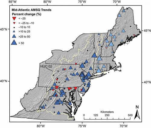
Fig. 1 Spatial distribution of trends in flood magnitude (AMSQ), represented as percent change over the period of record for each gauge. Darker colored symbols are new data presented in this study. Lighter colored symbols are HUC 01 (New England) streams from Collins (Citation2009) and are presented here to provide regional context. New England symbol sizes are scaled with the same criteria as Mid-Atlantic symbols.
We review gauge metadata in detail, including USGS annual water data reports and peak discharge qualification codes, and remove any gauge records that have (1) evidence of peak flow regulation and/or diversion (e.g. peak discharge qualification codes 5 or 6); (2) fewer than 59 years of record (i.e. all records start in WY 1951 or earlier to ensure adequate record length before 1970 for our step change investigation); (3) records ending before WY 2009; or (4) more than 5% missing data (i.e. no more than 5 missing annual peaks in a 100 year record). Our longest span of consecutive missing years is three years, which occurs only at one gauge. Ninety-five percent of our gauges have one missing year or fewer. Additionally, we remove several gauges for unique disqualifiers. For example, we exclude a New Jersey gauge record because dredging and channel realignment around 1960, reported in the state annual water data reports, could have affected peak discharges.
Seventy-five MAR gauges have AMS records that satisfy these criteria (). The study gauges are fairly well distributed throughout the study region, though southeastern Pennsylvania, eastern Maryland, and Delaware are unrepresented, likely due to significant urbanization in these areas. We obtain AMS discharge data (AMSQ) for the study gauges from the National Water Information System (NWIS; accessible at http://nwis.waterdata.usgs.gov/usa/nwis/peak/). Eight gauges did not maintain POT data for significant portions of their periods of record or had TD changes that affected data quality, leaving 67 gauges for POT/WY trend analyses. POT data are not available through NWIS, so we obtain these data directly from USGS state Water Science Centers. The shortest period of record we use is 61 years, and the longest is 102 years, with an average record length of around 80 years (). The rivers drain a wide range of watershed sizes, from 62 to 10 550 km2, with a median basin size of about 450 km2.
Table 1 Trends in Mid-Atlantic flood magnitude (AMSQ) and frequency (POT/WY). Bold font indicates statistical tests with p-values < 0.05.
2.3 Trend analyses
Before formal statistical testing, we conduct exploratory data analyses using scatter plots and other data visualizations to detect potential errors in the data and ensure that they satisfy the assumptions of the tests we employ (Helsel and Hirsch Citation2002). Flood data are frequently non-normally distributed, so we have chosen non-parametric tests that require no distributional assumptions.
We use the Mann-Kendall trend test (MK) to detect monotonic trends in AMSQ and POT/WY. The MK is a non-parametric, rank-based test that describes the strength of the relationship between time and a variable of interest (e.g. AMSQ and POT/WY) (Helsel and Hirsch Citation2002). It is widely employed in hydrologic change investigations. We estimate the magnitude of AMSQ trends using the non-parametric Kendall-Theil robust line with Sen slope. We do not calculate trend magnitude for POT/WY trends because the discrete form of POT data results in many ties between compared points, which confounds the test statistic.
We use the non-parametric Wilcoxon rank-sum test to investigate step changes in AMSQ and POT/WY because it is well suited for situations when the time of change is known or expected (Helsel and Hirsch Citation2002, Kundzewicz and Robson Citation2004). For each gauge, we separate the record into two sub-series at 1970, a year around which many studies have noted step changes in hydrologic variables in the northeastern United States (McCabe and Wolock Citation2002, Mauget Citation2003, Collins Citation2009, Hodgkins Citation2010, Villarini and Smith Citation2010, Armstrong et al. Citation2012). For our analyses, the pre-1970 sub-series begins at the start of the record and continues through the end of WY 1970 (September 30, 1970). The post-1970 sub-series begins at the start of WY 1971 and ends with WY 2009. The rank-sum test compares these two samples and evaluates whether one sample consistently tends to produce larger values than the other, which would suggest the samples come from two distinct populations. We use a p < 0.05 threshold to identify gauges with comparatively strong evidence for step changes in AMSQ and POT/WY.
2.4 Persistence and spatial correlation
Statistical tests that assume data are independent and identically distributed, such as the MK and rank-sum tests, may overestimate trend significance (i.e. show lower p-values) if the data are positively autocorrelated (Yue et al. Citation2002). Autocorrelation can affect time series over long and/or short periods, which we refer to here as long term persistence (LTP) and serial correlation, respectively. The magnitude and direction of the MK and rank-sum test statistics are not affected by positive autocorrelation—only the estimates of their statistical significance.
To evaluate whether serial correlation affects our AMSQ time series, we use locally weighted regression (LOESS) with a smoothing parameter of 0.5 and compute Kendall’s tau between the residuals and lag-one residuals (Cleveland and Devlin Citation1988, Helsel and Hirsch Citation2002, Collins Citation2009, Armstrong et al. Citation2012). As expected, we found no evidence for lag-one serial correlation in any of our AMSQ records at a p < 0.05 threshold.
POT data can show positive serial correlation in magnitude (i.e. the magnitude of one flood affects that of a subsequent flood, suggesting they may be generated by the same meteorological event) and/or in frequency (i.e. independent floods can occur in temporal clusters). However, as described below, relatively modest additional analyses and data processing can reduce the serial dependencies in these data series without significant data loss and subsequently employing resampling methods can permit robust p-value estimates.
Although the USGS performs quality control reviews on POT data and makes efforts to ensure the independence of sequential flood events (Julie Kiang, USGS, 2009, personal communication), we impose an additional criterion. We use centroid lag to peak (TLPC) as a rough measure of watershed response time to remove temporally close POT that may have been caused by the same meteorological event. We calculate TLPC, in hours, with the formula:
POT time series that have been processed as described above to assure independent flood events may still exhibit serial correlation in frequency. That is, some water years may have higher numbers of independent flood events than others such that events are not randomly distributed in time (Cunnane Citation1979, Robson et al. Citation1998). To address these dependencies in the time series, for all statistical analyses of our POT data we employ Monte Carlo resampling methods to estimate trend significance directly from the data and thus require no distributional, or independence, assumptions. Using methods described by Robson et al. (Citation1998) and Kundzewicz and Robson (Citation2000), we resample our POT/WY time series without replacement (permutation) 1000 times in WY blocks to construct null distributions for our respective test statistics (our results at 1000 iterations are stable as demonstrated by resampling the time series 10000 times and achieving nearly identical results for all tests). We then estimate the p-value for each test by comparing the test statistic calculated from the original time series to the null distribution of the test statistic generated through resampling. Test statistics lying near the extremes of the null distribution have lower p-values and provide stronger evidence for rejecting the null hypothesis of no change or trend (Kundzewicz and Robson Citation2000).
Several recent studies have also highlighted the similar effects LTP can have on trend significance estimates, while trend direction and magnitude are unaffected (Yue et al. Citation2002, Cohn and Lins Citation2005, Koutsoyiannis and Montanari Citation2007). Because our record lengths are too short to either confirm or discount LTP in our time series (Villarini et al. Citation2009), we present p-values as indicators of relative trend strength but do not emphasize statistical significance. We evaluate relative trend strength using p < 0.05 as a threshold. This approach allows us to present our results in a manner consistent with many earlier hydrologic trend studies and facilitates the identification of trends that may be important over engineering and planning time scales (101–102 years) even if they may not be statistically significant over longer time periods (>102 years) (Collins Citation2009, Douglas and Fairbank Citation2011, Armstrong et al. Citation2012).
Lettenmaier et al. (Citation1994) and Douglas et al. (Citation2000) showed that spatial correlation can substantially reduce the number of independent sites in streamflow trend analyses. However, as with many previous trend studies, we do not evaluate trends using a single regional test statistic and therefore we do not need to explicitly account for spatial correlation (McCabe and Wolock Citation2002, Lins and Slack Citation2005, Collins Citation2009, Armstrong et al. Citation2012). Moreover, we evaluate the global, or field, significance of our flood trend results using two methods described by Wilks (Citation2006) that are robust to spatial correlation: the Walker test (WT) and the false discovery rate (FDR) method.
2.5 Investigating potential linkages with large-scale atmospheric circulation patterns
2.5.1 Atmospheric circulation indices
Collins (Citation2009) and Armstrong et al. (Citation2012) found positive, lagged correlations between NAO phase and flood magnitude and frequency in New England. We expand upon these studies by adding MAR stream gauges and investigating NAO and ENSO linkages with AMSQ and POT/WY for the entire northeastern US (HUC 01 and HUC 02) using a method adapted from Tootle et al. (Citation2005). This method allows us to examine the effect of phase couplings between the NAO and ENSO and to examine flood linkages at a finer spatial scale (Collins (Citation2009) and Armstrong et al. (Citation2012) used regionally averaged flood data).
The NAO describes an exchange of atmospheric mass between a high-pressure centre approximately located over the Azores Islands and a low-pressure centre over Iceland. The NAO index quantifies the strength of the pressure gradient between these two centres of action, where a positive (negative) phase indicates anomalously strong (weak) pressure centres. The magnitude of the gradient influences the strength of the prevailing westerlies, surface air temperature, sea-surface temperature (SST), storm tracks, moisture transport, and other climatological variables in the northeastern US (Hurrell et al. Citation2003, Hurrell and Deser Citation2010). The NAO phase exhibits decadal persistence despite significant intra- and interannual variability (Hurrell et al. Citation2003). The early 20th century was characterized by positive NAO departures, followed by frequent negative NAO events through the 1950s–1960s, and then a reversal to predominantly positive NAO events after the 1970s (Hurrell et al. Citation2003). We use the principal component (PC) based NAO index averaged over the months of December to March (DJFM), obtained from the National Center for Atmospheric Research (NCAR; accessible at http://www.cgd.ucar.edu/cas/jhurrell/indices.data.html). The PC based index is composed of the leading empirical orthogonal function of sea level pressure anomalies over the Atlantic Ocean from 20–80°N and 90°W–40°E. We use the DJFM index because the NAO signal is strongest in the winter, when the temperature gradient between the poles and equator is steepest (Hurrell et al. Citation2003) and because our recent studies have found lagged associations between the DJFM NAO index but not the NAO index computed for other seasons or annually (Collins Citation2009, Armstrong et al. Citation2012).
ENSO is a combined oceanic-atmospheric phenomenon related to the strength of the tropical Pacific easterlies. The ENSO phase is known to affect sea level pressure and storm frequency in the eastern US (Rogers Citation1984, Kunkel and Angel Citation1999, Hirsch et al. Citation2001). We use the Troup Southern Oscillation Index (SOI), which is the standardized anomaly of the mean difference in sea level pressure between Tahiti and Darwin, Australia, obtained from NCAR (accessible at http://www.cgd.ucar.edu/cas/catalog/climind/soiAnnual.html) to quantify the ENSO conditions. We use monthly SOI data that have been normalized using annual means, which produces the maximum signal-to-noise ratio (Trenberth Citation1984). We also averaged monthly SOI over the December–March period to produce a winter SOI. We use a winter index to be consistent with our NAO analyses and because studies have shown ENSO teleconnections in the mid-latitudes are strongest in the winter (Dettinger et al. Citation2000, Bradbury et al. Citation2002a).
2.5.2 Testing for NAO/ENSO linkages with northeastern US flooding
We investigate linkages between NAO/ENSO phase and northeastern US floods using data from 1941 to 2006 to maintain relatively long record lengths while keeping a large proportion of our study gauges and to be consistent with our earlier work (Collins Citation2009, Armstrong et al. Citation2012). We investigate NAO/ENSO linkages over a larger spatial area than our flood trend analyses presented here by adding the New England gauges used by Collins (Citation2009) and Armstrong et al. (Citation2012). Fifty-two (forty-seven) MAR gauges and 23 (19) New England gauges have AMS (POT) records with adequate length and are included in this portion of the study. Hereafter we refer to New England and the MAR together as simply the northeastern US.
For each of the atmospheric indices, we classify each year of record as positive, negative, or neutral. For the NAO, we define neutral events as years in which the NAO index was between –0.2 and +0.2. Using this classification yields 26 NAO positive years, 26 NAO negative years, and 14 NAO neutral years (NAO (+); NAO (–); NAO (0), respectively). We recognize that it is more commonplace for hydroclimatic studies that identify a neutral NAO condition to identify larger index thresholds (e.g. ±0.5 or ±1) (Hurrell Citation2003, Coleman and Budikova Citation2013). However, our purpose is not to identify high/low, or ‘extreme’, phases of the NAO. Instead, we aim to define conservatively a neutral condition simply to avoid a binary positive or negative assignment when the index is near zero. We experimented with larger threshold values that reasonably define neutral conditions and found that our comparisons of flood response to NAO phase are not very sensitive to the threshold choice. Our choice of +/– 0.2 has the advantage of producing similar relative proportions of positive, negative, and neutral years to those obtained with our definition of a neutral ENSO event. For ENSO, we define a neutral event as a year in which the SOI was between – 0.8 and +0.8 (Gershunov and Barnett Citation1998, Tootle et al. Citation2005). This classification produces 21 SOI positive years, 33 SOI negative years, and 12 SOI neutral years (SOI (+); SOI (–); SOI (0), respectively).
We then perform rank-sum tests between the flood data corresponding with each index phase (e.g. AMSQ from NAO (+) years versus AMSQ from NAO (0) years). We also test for effects of NAO/ENSO phase couplings (Tootle et al. Citation2005). For example, we run a rank-sum test between POT/WY from years in which the NAO and SOI were both in positive phases (NAO (+), SOI (+)) and POT/WY from years when the NAO was positive, but SOI was negative (NAO (+), SOI (–)). This allows us to assess the extent to which these large-scale atmospheric circulation patterns enhance and/or moderate each other. In addition to performing these tests concurrently (i.e. index data paired with flood data from the same water year), we perform all tests described in this section using lag-one flood data (i.e. SOI/NAO index data paired with flood data from the following water year).
3 RESULTS
3.1 Mid-Atlantic AMSQ trends
Fifty-three of the 75 MAR study gauges (71%) show upward trends in AMSQ via the Mann-Kendall trend test. Twelve (16%) are increasing at p < 0.05. Twenty-one gauges (28%) show decreasing trends in AMSQ, none of which have p < 0.05. One gauge shows no trend (; ). The percent change in AMSQ, estimated via the Kendall-Theil robust line, ranges from −31% to +161%, with a mean change of +20% and a median of +19%. Upward trends in AMSQ are generally widespread throughout the northeastern US and are field significant at α = 0.05 via the WT and FDR methods (). Although it is difficult to separate coastal from orographic effects because of the orientation of the region’s topography, we find a negative correlation between trend magnitude and distance from the open Atlantic Ocean, with coastal gauges generally showing greater trend magnitude than inland gauges (tau = –0.196, p = 0.013). We note that Smith et al. (Citation2010, Citation2011) have identified orographic effects as playing an important role in extreme flooding in the northeastern US. We find no correlation between trend magnitude and mean basin elevation. As with our earlier work, area-adjusted trend magnitude has an expected significant negative correlation with drainage area (tau = –0.297, p < 0.001) (Collins Citation2009, Armstrong et al. Citation2012).
3.2 Mid-Atlantic POT/WY trends
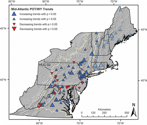
Fifty of the 67 gauges (75%) with POT data show increasing trends in POT/WY via the Mann-Kendall trend test. Eighteen (27%) are increasing at p < 0.05. Seventeen gauges (25%) show decreasing trends in POT/WY, none of which have p < 0.05 (). POT/WY trends are distributed in a similar pattern to magnitude trends, with upward trends characterizing much of the MAR, similar to the increases observed in New England () (Armstrong et al. Citation2012). These results are field significant at α = 0.05 via the WT and FDR methods. However, we find a roughly northwest-southeast oriented sub-region of negative trends running from central Pennsylvania, through northern Maryland, to southern New Jersey.
Fig. 2 Spatial distribution of trends in flood frequency (POT/WY). Larger symbols indicate trends with p < 0.05. Darker colored symbols are new data presented in this study. Lighter colored symbols are HUC 01 (New England) streams from Armstrong et al. (Citation2012) and are presented here to provide regional context. New England symbol sizes are scaled with the same criteria as Mid-Atlantic symbols.
3.3 Evidence for step changes in Mid-Atlantic flood regime
Sixty-three of 75 gauges (84%) have greater AMSQ post-1970 estimated via the Wilcoxon rank-sum test: 20 gauges (27%) have greater post-1970 AMSQ at p < 0.05, suggesting a step increase in AMSQ around 1970; 12 gauges have smaller AMSQ post-1970, none of which have p < 0.05 (). The spatial distribution of step changes generally follows the same pattern as MK trends in AMSQ (not shown).
Sixty gauges of 67 (90%) have more POT/WY post-1970 via the Wilcoxon rank-sum test: 28 gauges (42%) have more POT/WY post-1970 at p < 0.05, indicating strong evidence for a step increase in POT/WY; and seven gauges (10%) have fewer POT/WY post-1970, none of which have p < 0.05 ().
Both the AMSQ and POT/WY step-change results are field significant at α = 0.05 via the WT and FDR methods.
3.4 NAO linkages with northeastern US flooding
For our investigation of linkages between flooding and large-scale atmospheric circulation, we expand our study area to include New England as well as the MAR. We find no evidence of a linkage between DJFM NAO phase and flooding in the same water year, in agreement with our previous investigations (Collins Citation2009, Armstrong et al. Citation2012). However, we do find evidence for the DJFM NAO phase affecting AMSQ and POT/WY in the following water year.
NAO (0) and NAO (+) are associated with larger lag-one AMSQ, while NAO (−) is associated with diminished lag-one AMSQ (). Though most of the study region tends to have larger AMSQ following NAO (+) and NAO (0) years, the central portion shows mixed results, including areas where NAO (−) is associated with larger lagged AMSQ ( and ).
Fig. 3 NAO linkages with lag-one flood magnitude (AMSQ). Symbols indicate which phase of the NAO is associated with larger AMSQ in the following water year. Larger, shaded plus (minus) symbols indicate gauges with significantly larger AMSQ (at p < 0.05) following the positive (negative) phase of the NAO.
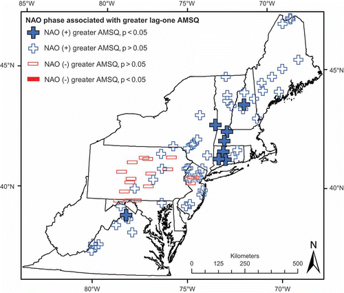
Fig. 4 Comparison of lag-one flood magnitude (AMSQ) following NAO (0) and NAO (–) winters. Symbols indicate which phase of the NAO is associated with larger AMSQ in the following water year. Larger, shaded circles (minuses) indicate gauges with significantly larger AMSQ (at p < 0.05) following the neutral (negative) phase of the NAO.
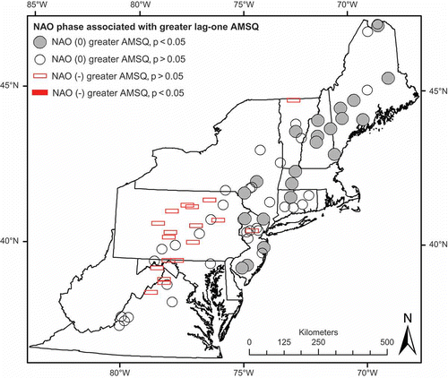
Table 2 Summary of NAO and ENSO linkages with lag-one flood magnitude (AMSQ) in the northeastern US.
Compared to our AMSQ investigation, we find a higher proportion of gauges show greater POT/WY following a given NAO phase, with greater proportions of p < 0.05 differences as well (–). Note we use 66 gauges for our investigation of linkages between atmospheric circulation and POT/WY, as opposed to the 75 gauges we use for the AMSQ analysis. NAO (0) events are generally associated with the most POT in the following WY, with the second greatest POT/WY following NAO (+) events. NAO (+) () and NAO (0) (not shown) are associated with greater lag-one POT/WY throughout the entire northeastern US, although we again find a small cluster of gauges in the central portion of the study area where the signal is not as strong.
Fig. 5 NAO linkages with lag-one flood frequency (POT/WY). Symbols indicate which phase of the NAO is associated with more POT in the following water year. Larger, shaded plus (minus) symbols indicate gauges with significantly more POT (at p < 0.05) following the positive (negative) phase of the NAO.
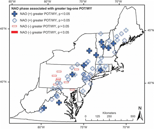
Table 3 Summary of NAO and ENSO linkages with lag-one flood frequency (POT/WY) in the northeastern U.S.
3.5 Northeastern US flood response to ENSO phase
The ENSO shows some evidence of affecting AMSQ in the same water year—the only atmospheric index-flood data pairing to show any effect when analysed concurrently. Fifty-six gauges (75%) have greater AMSQ in SOI (+) years than SOI (–) years, though only one has p < 0.05. These findings agree with those of Dracup and Kahya (Citation1994) who found SOI (+) to be associated with positive monthly streamflow departures in the northeastern US. Note SOI (+) indicates La Niña-like conditions and SOI (–) indicates El Niño-like conditions. Lagging AMSQ by one year, SOI (–) has a stronger association with greater AMSQ than SOI (+) or SOI (0), though few have p < 0.05 (). AMSQ is similar following SOI (+) and SOI (0) events. ENSO teleconnections with AMSQ are strongest in the more southern portions of our study region, with the southernmost gauges experience larger flooding following SOI (–) years, while the central portion shows some evidence for larger flooding following SOI (+) ().
Fig. 6 ENSO teleconnections with lag-one flood magnitude (AMSQ). Symbols indicate which phase of the SOI is associated with larger AMSQ in the following water year. Larger, shaded plus (minus) symbols indicate gauges with significantly larger AMSQ (at p < 0.05) following the positive (negative) phase of the NAO.
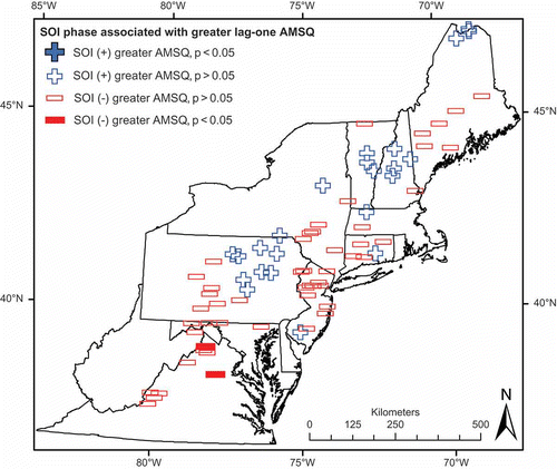
The ENSO appears to play a similar, limited role in affecting POT/WY in the northeastern US. We find no concurrent relationship between SOI phase and POT/WY. Analysing the lagged data, we find SOI (−) produces more POT/WY than both SOI (+) and SOI (0) at a majority of gauges, though just 1 has p < 0.05 (). SOI (+) is associated with greater lag-one POT/WY than SOI (0), though the relationship is not as clear as the comparison between SOI (0) and SOI (−) ().
3.6 Effect of atmospheric circulation couplings
We find no evidence for enhanced flood response to any phase couplings of ENSO and NAO. Couplings that held NAO constant (e.g. NAO (+), SOI (+) vs NAO (+), SOI (−)) show a weaker difference between pairings than those comparing the effect of SOI phase alone. We find the same for couplings that held SOI phase constant and changed NAO phase.
4 DISCUSSION
Our results show widespread upward trends in flood magnitude (AMSQ) and frequency (POT/WY) throughout the Mid-Atlantic US. (–) that have, in many cases, occurred as a step trend around 1970 (). The magnitude of the annual flood has increased by more than 25% at nearly half of all AMSQ stations and increases greater than 50% are not uncommon across the region. Increases in flood frequency (POT/WY) are also widespread. Together with our earlier New England investigations, (i.e. Collins Citation2009, Armstrong et al. Citation2012), we see stepped, upward trends in AMSQ and POT/WY from Virginia to northern Maine in watersheds draining to the Atlantic Ocean. These results are broadly similar to those of Villarini and Smith (Citation2010) and Rice and Hirsch (Citation2012) for the northern parts of their study domains, but, not surprisingly, our signals are more pronounced given our exclusion of regulated watersheds. Despite the general ubiquity of the increasing trends, we do find a region around northern Maryland and central Pennsylvania that is characterized by weaker trends, and several decreasing trends, in both AMSQ and POT/WY (–). Understanding why this sub-region shows a different flood response requires further detailed watershed and hydroclimatological analyses beyond the scope of this study.
Many changes in flood characteristics of US streams have been linked to human activities such as dam construction, watershed urbanization, and/or changes in agricultural practices (e.g. Booth and Jackson Citation1997, Allan Citation2004, Villarini et al. Citation2009). However, we believe the trends we document here are not dominantly results of anthropogenic land-use change and/or direct flow modification for two reasons.
First, as noted above, we took considerable care to select gauges in watersheds with minimal regulation and/or land-use changes that would affect flood flows over their periods of record. To do so, we began by choosing HCDN stream gauges and took several additional measures to investigate the suitability of each watershed for our analyses. We believe these efforts have produced a gauge set that considerably reduces the risk of confusing direct watershed anthropogenic impacts (e.g. land-use change and/or flow regulation) with hydroclimatic causes of flood trends (Hirsch and Ryberg Citation2012). This is supported by the conclusion of Smith et al. (Citation2010) that large flood trends observed in the Beaver Kill watershed, which stood out in their study of Delaware River basin flooding and are among the largest we document (), are not dominantly caused by changes in land use.
Second, agricultural abandonment and reforestation documented in the MAR (likely preferentially in rural areas where HCDN watersheds are located) over the last century is a passive anthropogenic impact that would tend to produce decreasing flood magnitudes and frequencies (Steyaert and Knox Citation2008, Ramankutty et al. Citation2010). Considering that this phenomenon is not accounted for in our gauge selection process, the strength of the upward trends we find is somewhat surprising and indicates the magnitude of the hydroclimatic forcing.
Precipitation has increased nationally by 10% over the 20th century (Karl and Knight Citation1998), much of which can be attributed to increases in the frequency and intensity of heavy precipitation events (Groisman et al. Citation2001, Citation2004). In agreement, Polsky et al. (Citation2000) found a 10% increase in MAR monthly mean precipitation over the 20th century. Increases have been especially pronounced in the northeastern US (Groisman et al. Citation2004, Madsen and Figdor Citation2007, Douglas and Fairbank Citation2011, Nguyen and DeGaetano Citation2012, Seager et al. Citation2012). Regional temperatures have also increased over the 20th century (Groisman et al. Citation2004). Recent modeling studies for the northeastern-most part of our study domain show that modeled flood magnitude increases associated with precipitation increases are reduced when temperatures are also increased, probably because of reduced winter snowpack and snowmelt runoff (Hodgkins and Dudley Citation2013). However, snowmelt is a notable flood-generating mechanism only in a relatively small part of our overall study area and it is primarily a factor in mixed rain-snowmelt regimes that show both increased and decreased flood risk in other studies that model air temperature increases (Hamlet and Lettenmaier Citation2007, Collins et al. Citation2014).
Our findings lead to several important questions. To what mechanisms can we attribute precipitation increases in the region and stepped upward trends in the magnitude and frequency of floods? Are these phenomena manifestations of natural variability in large-scale atmospheric circulation patterns and/or SST anomalies or evidence of anthropogenic warming? Are the two mutually exclusive?
To explore these questions, we analysed linkages among the flood trends we observed and two atmospheric circulation patterns known to affect hydroclimate in the northeastern US (NAO and ENSO). Of the relationships between flooding metrics and the atmospheric indices, we find the strongest evidence for lagged positive relationships between the winter (DJFM) NAO and AMSQ of the following water year (beginning on October 1) and the winter NAO and POT/WY of the following water year (–). Thus, the time lags for these relationships are a minimum of 6 months. These linkages are evident throughout the study region, but are most prominent in the northeastern portion (–). While the NAO is a persistent atmospheric phenomenon and is thus a mechanism of natural climate variability, the prevalence of NAO (+) winters since the 1970s may be related to anthropogenic climate warming and may favor NAO positive phases in the future (Gillett et al. Citation2003, Hurrell et al. Citation2003, Lu et al. Citation2004, Rind et al. Citation2005, Osborn Citation2011).
Bradbury et al. (Citation2002a) and Kingston et al. (Citation2007) have identified weak, but statistically significant, positive relationships between the NAO and various New England streamflow indices and noted that negative NAO is associated with drier conditions in New England (Bradbury et al. Citation2002b). Kingston et al. (Citation2007) caution, however, that the positive relationships they identify between New England streamflow and the NAO are complex and require further investigation. A question that naturally arises from our findings is: how can a positive winter NAO, which is associated with warmer wetter conditions in the northeastern US, affect flood magnitude and frequency in the following water year? We suspect that any influence must be through the effect of the winter NAO on antecedent soil moisture conditions. This is problematic, however, when one considers that dry conditions in the intervening warm season could easily erase any increased soil moisture from the previous winter.
However, recent research by Steinschneider and Brown (Citation2011) and Coleman and Budikova (Citation2013) suggest mechanisms by which such gains may be preserved and/or enhanced into the following water year. For example, Steinschneider and Brown (Citation2011) found a positive correlation between the winter NAO phase and late summer one- and seven-day low flow in the Connecticut River basin in New England. They suggest this linkage is driven by positive SST anomalies related to the winter NAO and a resultant effect on regional storm tracks that persists into the summer such that more storms make landfall with the eastern US. This increases precipitation delivery to the region, resulting in higher than average late summer streamflow (Steinschneider and Brown Citation2011). Greater late season flow indicates higher water tables and greater soil moisture. Such conditions could predispose streams towards greater and more frequent flooding when autumn and winter storms begin. Indeed, Hodgkins and Dudley (Citation2011) document increasing trends in mean summer base flow and summer 7-day low base flow over much of New England.
Coleman and Budikova (Citation2013) also find positive, lagged relationships between the winter NAO and mean daily summer streamflow in the northeastern US and suggest atmospheric mechanisms to explain the relationships. They show how the positive relationships may be driven mostly by negative NAO conditions, which produce negative mean daily summer streamflow anomalies in the northeastern US, while the positive (and neutral) phases produce average flows. Interestingly, our investigations (–) also suggest that negative winter NAO conditions may have a stronger effect on flood-producing conditions for the following water year (i.e. reducing them) than positive winter NAO conditions because both positive and neutral phases are associated with greater lag-one AMSQ and POT/WY.
Another indicator that regional flooding has some relationship with the NAO is the step changes we observe in our flood series around 1970. This step change is contemporaneous with a well-known shift of the NAO from a dominantly negative phase in the 1950s and 1960s to a dominantly positive phase after that time (Hurrell et al. Citation2003, Collins Citation2009).
However, our results and the recent work of others (Kingston et al. Citation2007, Seager et al. Citation2012) suggest that observed changes in flooding are at most complexly, and not exclusively, related to the NAO via its potential influence on storm tracks and antecedent soil moisture conditions. Floods are episodic phenomena, so we should also consider other recently documented changes in North Atlantic basin atmospheric conditions that may also affect conditions at the event scale. Seager et al. (Citation2012) were unable to clearly identify a single mechanism for increased precipitation in the MAR after 1970, but they ruled out SST anomalies and instead concluded that the recent wet period is primarily a function of internal atmospheric dynamics. They document that the post-1970 increase in MAR precipitation is strongest in the spring and fall (which we note are the seasons that correspond with the primary and secondary streamflow maxima in the region, respectively), apparently related to atmospheric pressure anomalies that promote southeasterly (spring) and southwesterly (fall) ascending atmospheric flow that promotes enhanced precipitation. They also find evidence that the post-1970 wet period may be related to a local strengthening of the Northern Hemisphere storm tracks across the continent, but caution that the strengthening should not be interpreted as having a direct correspondence with the NAO trend (Seager et al. Citation2012).
Nguyen and Degaetano (Citation2012) document that the frequency of closed lows in the northeastern US, and the precipitation quantity associated with them, has increased significantly since the late 1940s—changes that are consistent with increased tropospheric water vapor expected with anthropogenic increases in global mean temperature. They note that closed lows are one synoptic mechanism associated with extreme rainfall in northeastern US. Francis and Vavrus (Citation2012) also show evidence that warming associated with increased greenhouse gas concentrations has affected conditions in the mid-latitudes in ways that promote atmospheric blocking, which is associated with increased frequency and intensity of extreme events. They document how Arctic warming causes weaker poleward thickness gradients, which in turn causes slower zonal winds and increased Rossby wave amplitudes in the mid-latitudes—both of these factors reduce the speed at which Rossby waves progress and thus increase atmospheric blocking.
Overall, our findings are consistent with previous studies that suggest observed increases in precipitation and flooding in the northeastern US may be related to a combination of factors that include cyclic atmospheric variability and secular changes in atmospheric conditions. It is not surprising that changes in flood magnitude and frequency may reflect a complex interaction of agents because streamflow in general, and floods in particular, are integrating metrics of the hydrologic cycle that reflect precipitation type, quantity, intensity, and duration; land cover; basin lithology and soil properties; basin relief and drainage density; and, importantly, antecedent conditions. The importance of the latter cannot be overstated. For example, hurricanes Floyd (in 1999) and Irene (in 2011; an event not included in our studies) had similar tracks and hydroclimatological attributes when they traversed Vermont, but they produced different flood responses (Sisson Citation2012). Antecedent moisture conditions in Vermont in the weeks preceding hurricane Irene set the stage for the largest floods in that state since 1927. Floods generated by Floyd, in contrast, were more modest.
5 SUMMARY
We find widespread stepped, upward trends in both flood magnitude and flood frequency throughout the MAR that are field significant. Fifty-three of 75 study gauges (71%) show increasing trends in AMSQ via the Mann-Kendall trend test (); 12 gauges (16%) are increasing at p < 0.05. No decreasing trends in AMSQ have p < 0.05 (). We find a median change in AMSQ of about +20% over the period of record. Twenty gauges (27%) show strong evidence for a step increase in AMSQ around 1970 via the Wilcoxon rank-sum test, in agreement with previous studies that show step increases in precipitation, streamflow, and flooding in the northeastern US around the same time () (McCabe and Wolock Citation2002, Mauget Citation2003, Collins Citation2009, Hodgkins Citation2010, Armstrong et al. Citation2012, Rice and Hirsch Citation2012).
Using resampling methods to address potential serial dependencies in our POT data, 50 of 67 gauges (75%) show field significant increasing trends in POT/WY—a direct measure of flood frequency: 18 gauges (27%) are increasing at p < 0.05; 17 gauges (25%) show decreasing trends in POT/WY, none of which have p < 0.05 (; ); and 28 gauges (42%) show strong evidence for a step increase in POT/WY around 1970 (). As explored by Collins (Citation2009) and Armstrong et al. (Citation2012), increasing trends in flood magnitude and/or frequency have important implications for flood risk estimation, restoration, and channel morphology.
The increases in AMSQ and POT/WY documented here for the MAR, combined with similar findings in New England (Collins Citation2009, Hodgkins Citation2010, Armstrong et al. Citation2012), are compelling evidence of hydroclimatic increases in flood magnitude and frequency throughout the northeastern US. Our work, in light of recent research, suggests that the flood trends we observe in the region are complexly related to atmospheric circulation variability and potentially secular trends related to climate warming that affect both antecedent conditions and processes at the event scale (Bradbury et al. Citation2002a, Citation2002b, Kingston et al. Citation2007, Steinschneider and Brown Citation2011, Francis and Vavrus Citation2012, Nguyen and DeGaetano Citation2012, Seager et al. Citation2012). Such complexity is expected since streamflow is an integrative metric of the hydrologic cycle and floods, in particular, are strongly influenced by the combination of conditions that obtain at a given time. Clearly, additional research is necessary to more fully understand all of the process linkages affecting floods in the region.
These results are less equivocal than those of earlier studies, which found a mix of upwards and downwards trends in high streamflow in the northeastern US (Lins and Slack Citation1999, Douglas et al. Citation2000, McCabe and Wolock Citation2002, Lins and Slack Citation2005, Small et al. Citation2006, Villarini et al. Citation2009, Villarini and Smith Citation2010, Rice and Hirsch Citation2012). We believe our data provide the best available description of the magnitude and direction of hydroclimatic flood trends in the region because of our (1) updated periods of record, (2) comparatively high density of stream gauges, and (3) substantial efforts to identify gauges with minimal human modification of flood hydrographs. While studies that do not exclude gauges influenced by regulation or other anthropogenic impacts that affect flooding present excellent documentation of flooding trends in general, their ability to draw conclusions about hydroclimatic changes is limited (e.g. Villarini and Smith Citation2010). We agree with the perspective articulated by Vogel et al. (Citation2011) that anthropogenic streamflow impacts are important and, when compounded with hydroclimatic trends, can result in larger changes in AMSQ and POT/WY than climatic forcing alone. However, studies attempting to isolate hydroclimatic streamflow trends are merited to understand trends that will be superimposed on any land-use-induced trends and could magnify or moderate changes in flow conditions depending on trend direction and magnitude. Furthermore, anthropogenic climate change is expected to influence the magnitude and frequency of extreme events and thus hydroclimatic trend investigations are useful for evaluating whether such changes are manifest in the instrumental record (Hirsch and Ryberg Citation2012).
Acknowledgements
We thank our colleague Andrew Miller and anonymous reviewers for comments that greatly improved earlier drafts of this manuscript. This research was partially funded by NOAA and National Science Foundation grant 0645343.
REFERENCES
- Allan, J.T., 2004. Landscape and riverscapes: the influence of land use on stream ecosystems. Annual Review of Ecology and Systematics, 35, 257–284.
- Armstrong, W.H., Collins, M.J., and Snyder, N.P., 2012. Increased frequency of low-magnitude floods in New England. Journal of the American Water Resources Association, 48 (2), 306–320. doi:10.1111/j.1752-1688.2011.00613.x
- Booth, D.B. and Jackson, C.R., 1997. Urbanization of aquatic systems: degradation thresholds, stormwater detection, and the limits of mitigation. Journal of the American Water Resources Association, 33 (5), 1077–1090.
- Bradbury, J.A., Dingman, S.L., and Keim, B.D., 2002a. New England drought and relationships with large scale atmospheric circulation patterns. Journal of the American Water Resources Association, 38 (5), 1287–1299.
- Bradbury, J.A., Keim, B.D., and Wake, C.P., 2002b. U.S. east coast trough indices at 500 hPa and New England winter climate variability. Journal of Climate, 15, 3509–3517.
- Cleveland, W.S. and Devlin, S.J., 1988. Locally-weighted regression—an approach to regression analysis by local fitting. Journal of the American Statistical Association, 83, 596–610. doi:10.2307/2289282
- Cohn, T.A. and Lins, H.F., 2005. Nature’s style: naturally trendy. Geophysical Research Letters, 32, L23402. doi:10.1029/2005GL024476
- Coleman, J.S. and Budikova, D., 2013. Eastern U.S. summer streamflow during extreme phases of the North Atlantic Oscillation. Journal of Geophysical Research: Atmosphere, 118 (10), 4181–4193. doi: 10.1002/jgrd.50326
- Collins, M.J., 2009. Evidence for changing flood risk in New England since the late 20th century. Journal of the American Water Resources Association (JAWRA), 45, 279–290. doi:10.1111/j.1752-1688.2008.00277.x
- Collins, M.J., et al., 2014. Annual floods in New England (USA) and Atlantic Canada: synoptic climatology and generating mechanisms. Physical Geography, 35 (3), 195–219. doi:10.1080/02723646.2014.888510
- Cunnane, C., 1979. A note on the Poisson assumption in partial duration series models. Water Resources Research, 15 (2), 489–494.
- Dettinger, M.D., et al., 2000. Multiscale streamflow variability associated with El Niño/Southern Oscillation. In: H.F. Diaz and V. Markgraf, eds. El Niño and the Southern Oscillation—Multiscale variability and global and regional impacts. Cambridge: Cambridge University Press, 113–146.
- Dingman, S.L., 2002. Physical hydrology. 2nd ed. Upper Saddle River, NJ: Prentice Hall.
- Douglas, E.M. and Fairbank, C.A., 2011. Is precipitation in northern New England becoming more extreme? A statistical analysis of extreme rainfall in Massachusetts, New Hampshire and Maine and updated estimates of the 100-year storm. Journal of Hydrologic Engineering, 16, 203–217. doi:10.1061/(ASCE)HE.1943-5584.0000303
- Douglas, E.M., Vogel, R.M., and Kroll, C.N., 2000. Trends in floods and low flows in the United States: impact of spatial correlation. Journal of Hydrology, 240, 90–105. doi:10.1016/S0022-1694(00)00336-X
- Dracup, J.A. and Kahya, E., 1994. The relationships between U.S. streamflow and La Niña events. Water Resources Research, 30 (7), 2133–2141. doi:10.1029/94WR00751
- Francis, J.A. and Vavrus, S.J., 2012. Evidence linking Arctic amplification to extreme weather in mid-latitudes. Geophysical Research Letters, 39, L06801. doi:10.1029/2012GL051000
- Gershunov, A. and Barnett, T.P., 1998. ENSO influence on intraseasonal extreme rainfall and temperature frequencies in the contiguous United States: observations and model results. Bulletin of the American Meteorological Society, 11, 1575–1586.
- Gillett, N.P., Graf, H.F., and Osborn, T.J., 2003. Climate change and the North Atlantic Oscillation. In: J.W. Hurrell et al., eds. The North Atlantic Oscillation: climate significance and environmental impact. Vol. 134. Geophysical Monograph Series. Washington, DC: AGU, 193–209.
- Groisman, P.Y., et al., 2004. Contemporary changes of the hydrological cycle over the contiguous United States: trends derived from in situ observations. Journal of Hydrometeorology, 5, 64–85.
- Groisman, P.Y., Knight, R.W., and Karl, T.R., 2001. Heavy precipitation and high streamflow in the contiguous United States: trends in the 20th Century. Bulletin of the American Meteorological Society, 82, 219–246. doi:10.1175/1520-0477(2001)0820219:HPAHSI2.3.CO;2
- Hamlet, A.F. and Lettenmaier, D.P., 2007. Effects of 20th century warming and climate variability on flood risk in the western U.S. Water Resources Research, 43, W06427. doi:10.1029/2006WR005099
- Helsel, D.R. and Hirsch, R.M., 2002. Statistical methods in water resources. Techniques of Water-Resource Investigations of the United States Geological Survey, Book 4, Chapter A3 [online]. Available from: http://pubs.usgs.gov/twri/ [Accessed November 2011].
- Hirsch, M.E., DeGaetano, A.T., and Colucci, S.J., 2001. An east coast winter storm climatology. Journal of Climate, 14, 882–889. doi:10.1175/1520-0442(2001)0140882:AECWSC2.0.CO;2
- Hirsch, R.M. and Ryberg, K.R., 2012. Has the magnitude of floods across the USA changed with global CO2 levels? Hydrological Sciences Journal, 57 (1), 1–9. doi:10.1080/02626667.2011.621895
- Hodgkins, G.A. 2010. Historical changes in annual peak flows in Maine and implications for flood-frequency analyses [online]. U.S. Geological Survey Scientific Investigations Report 2010–5094, 38 pp. Available from: http://pubs.usgs.gov/sir/2010/5094/ [Accessed February 2011].
- Hodgkins, G.A. and Dudley, R.W., 2005. Changes in the magnitude of annual and monthly streamflows in New England, 1902–2002. U.S. Geological Survey Scientific Investigations Report 2005–5135, 44 pp.
- Hodgkins, G.A. and Dudley, R.W., 2011. Historical summer base flow and stormflow trends for New England rivers. Water Resources Research, 47, W07528. doi:10.1029/2010WR009109
- Hodgkins, G.A. and Dudley, R.W., 2013. Modeled future peak streamflows in four coastal Maine rivers [online]. U.S. Geological Survey Scientific Investigations Report 2013–5080, 18 p. Available from: http://pubs.usgs.gov/sir/2013/5080/ [Accessed February 2011].
- Hurrell, J.W. and Deser, C., 2010. North Atlantic climate variability: the role of the North Atlantic Oscillation. Journal of Marine Systems, 79, 231–244. doi:10.1016/j.jmarsys.2009.11.002
- Hurrell, J.W., et al., 2003. An overview of the North Atlantic Oscillation. In: J.W. Hurrell et al., eds. The North Atlantic Oscillation: climate significance and environmental impact. Vol. 134. Geophysical Monograph Series. Washington, DC: AGU, 1–35.
- Karl, T.R. and Knight, R.W., 1998. Secular trends of precipitation amount, frequency, and intensity in the United States. Bulletin of the American Meteorological Society, 79 (2), 231–241. doi:10.1175/1520-0477(1998)0790231:STOPAF2.0.CO;2
- Kingston, D.G., et al., 2007. Large-scale climatic controls on New England river flow. Journal of Hydrometeorology, 8, 367–379. doi:10.1175/JHM584.1
- Kundzewicz, Z.W. and A.J. Robson eds., 2000. Detecting trend and other changes in hydrologic data, Rep. WCDMP-45, Rep. WMO-TD 1013, 157 pp. Geneva: World Meteorological Organization.
- Koutsoyiannis, D. and Montanari, A., 2007. Statistical analysis of hydroclimatic time series: uncertainty and insights. Water Resources Research, 43, W05429. doi:10.1029/2006WR005592
- Kundzewicz, Z.W. and Robson, A.J., 2004. Change detection in hydrological records – a review of the methodology. Hydrological Sciences Journal, 49 (1), 7–19.
- Kunkel, K.E. and Angel, J.R., 1999. Relationship of ENSO to snowfall and related cyclone activity in the contiguous United States. Journal of Geophysical Research, 104 (D16), 19425–19434.
- Langbein, W.B., 1949. Annual floods and the partial-duration flood series. American Geophysical Union, 30 (6), 879–881.
- Leopold, L.B. and Wolman, M.G., 1960. River meanders. Bulletin of the Geological Society of America, 88, 1845–1860. doi:10.1130/0016-7606(1960)71[769:RM]2.0.CO;2
- Lettenmaier, D.P., Wood, E.F., and Wallis, J.R., 1994. Hydroclimatological trends in the continental United States, 1948–88. Journal of Climate, 7, 586–607. doi:10.1175/1520-0442(1994)0070586:HCTITC2.0.CO;2
- Lins, H.F. and Slack, J.R., 1999. Streamflow trends in the United States. Geophysical Research Letters, 26 (2), 227–230.
- Lins, H.F. and Slack, J.R., 2005. Seasonal and regional characteristics of U.S. streamflow trends in the United States from 1940 to 1999. Physical Geography, 26 (6), 489–501. doi:10.2747/0272–3646.26.6.489
- Lu, J., Greatbatch, R.J., and Peterson, K.A., 2004. Trend in Northern Hemisphere winter atmospheric circulation during the last half of the twentieth century. Journal of Climate, 17, 3745–3760.
- Madsen, T. and Figdor, E., 2007. When it rains, it pours: global warming and the rising frequency of extreme precipitation in the United States [online]. Environment Rhode Island. Available from: http://www.environmentrhodeisland.org [Accessed January 2008].
- Mauget, S.A., 2003. Multidecadal regime shifts in U.S. streamflow, precipitation, and temperature at the end of the twentieth century. Journal of Climate, 16, 3905–3916. doi:10.1175/1520-0442(2003)0163905:MRSIUS2.0.CO;2
- McCabe, G.J. and Wolock, D.M., 2002. A step increase in streamflow in the conterminous United States. Geophysical Research Letters, 29 (24), 2185. doi:10.1029/2002GL015999
- Nguyen, L.T. and DeGaetano, A.T., 2012. A climatology of 500-hPa closed lows and associated precipitation in the northeastern United States. Journal of Applied Meteorology and Climatology, 51, 3–15. doi/10.1175/JAMC-D–10–05028.1
- Osborn, T.J. 2011. Variability and changes in the North Atlantic Oscillation index. In: S.M. Vicente-Serrano and R.M. Trigom, eds. Hydrological, socioeconomic, and ecological impacts of the North Atlantic Oscillation in the Mediterranean region. Advances in Global Change Research 46:9–22. doi:10.1007/978-94-007-1372-7_2
- Petrow, T. and Merz, B., 2009. Trends in flood magnitude, frequency, and seasonality in Germany in the period 1951–2002. Journal of Hydrology, 371, 129–141. doi:10.1016/j.jhydrol.2009.03.024
- Poff, N.L., 2002. Ecological response to and management of increased flooding caused by climate change. Philosophical Transactions of the Royal Society of London Series A, 360, 1497–1510. doi:10.1098/rsta.2002.1012
- Polsky, C., et al., 2000. The Mid-Atlantic region and its climate: past, present, and future. Climate Research, 14, 161–173.
- Ramankutty, N., Heller, E., and Rhemtulla, J., 2010. Prevailing myths about agricultural abandonment and forest regrowth in the United States. Annals of the Association of American Geographers, 100 (3), 502–512.
- Rice, K.C. and Hirsch, R.M., 2012. Spatial and temporal trends in runoff at long-term streamgages within and near the Chesapeake Bay Watershed [online]. U.S. Geological Survey Scientific Investigations Report 2012–5151, 56 pp. Available from: http://pubs.usgs.gov/sir/2012/5151/ [Accessed January 2013].
- Rind, D., Perlwitz, J., and Lonergan, P., 2005. AO/NAO response to climate change: respective influences of stratospheric and tropospheric changes. Journal of Geophysical Research, 110, D12107. doi:10.1029/2004JD005103
- Robson, A.J., et al., 1998. A study of national trend and variation in UK floods. International Journal of Climatology, 18, 165–182. doi:10.1002/(SICI)1097-0088(199802)18:2165::AID-JOC2303.0.CO;2-#
- Rogers, J.C., 1984. The association between the North Atlantic Oscillation and the Southern Oscillation in the northern hemisphere. Monthly Weather Review, 112, 1999–2015.
- Seager, R., et al., 2012. The 1960s drought and the subsequent shift to a wetter climate in the Catskill mountains region of the New York City watershed. Journal of Climate, 25, 6721–6742. doi:10.1175/JCLI-D–11–00518.1
- Sisson, P.A., 2012. Tropical cyclone Irene’s devastating flash flooding in Vermont on 28 August 2011, paper presented at the Lake Champlain Basin Flood Resilience conference, Burlington, VT.
- Slack, J.R. and Landwehr, J.M., 1992. Hydro-Climatic Data Network: A U.S. Geological Survey streamflow data set for the United States for the study of climate variations, 1874–1988. U.S. Geological Survey Open-File Report 92–129, Reston, VA.
- Small, D., Islam, S., and Vogel, R., 2006. Trends in precipitation and streamflow in the eastern U.S.: paradox or perception? Geophysical Research Letters, 33, L03403. doi:10.1029/2005GL024995
- Smith, J.A., et al., 2010. The hydrology and hydrometeorology of flooding in the Delaware River Basin. Journal of Hydrometeorology, 11, 841–859. doi: 10.1175/2010JHM1236.1
- Smith, J.A., Villarini, G., and Baeck, M.L., 2011. Mixture distributions and the hydroclimatology of extreme rainfall and flooding in the eastern United States. Journal of Hydrometeorology, 12, 294–309. doi:10.1175/2010JHM1242.1
- Spierre, S.G. and Wake, C.P., 2010. Trends in extreme precipitation events for the northeastern United States 1948–2007. Carbon Solutions New England Report and Clean Air-Cool Planet Report.
- Steinschneider, S. and Brown, C., 2011. Influences of North Atlantic climate variability on low-flows in the Connecticut River Basin. Journal of Hydrology, 409, 212–224.
- Steyaert, L.T. and Knox, R.G., 2008. Reconstructed historical land cover and biophysical parameters for studies of land-atmosphere interactions within the eastern United States. Journal of Geophysical Research, 113, D02101. doi:10.1029/2006JD008277
- Svensson, C., Kundzewicz, Z.W., and Maurer, T., 2005. Trend detection in river flow series: 2. Flood and low-flow index series. Hydrological Sciences Journal, 50 (5), 811–824. doi:10.1623/hysj.2005.50.5.811
- Tootle, G.A., Piechota, T.C., and Singh, A., 2005. Coupled oceanic-atmospheric variability and U.S. streamflow. Water Resources Research, 41, W12408. doi:10.1029/2005WR004381
- Trenberth, K.F., 1984. Signal versus noise in the Southern Oscillation. Monthly Weather Review, 12, 326–332.
- Villarini, G., et al., 2009. On the stationarity of annual flood peaks in the continental United States during the 20th century. Water Resources Research, 45, W08417. doi:10.1029/2008WR007645
- Villarini, G., et al., 2012. Analyses of extreme flooding in Austria over the period 1951–2006. International Journal of Climatology, 32, 1178–1192. doi: 10.1002/joc.2331
- Villarini, G. and Smith, J.A., 2010. Flood peak distributions for the eastern United States. Water Resources Research, 46, W06504. doi:10.1029/2009WR008395
- Vogel, R.M., Yaindl, C., and Walter, M., 2011. Nonstationarity: flood magnification and recurrence reduction factors in the United States. Journal of the American Water Resouces Association, 47 (3), 464–473.
- Wilks, D.S., 2006. On “field significance” and the false discovery rate. Journal of Applied Meteorology and Climatology, 45, 1181–1189. doi:10.1175/JAM2404.1
- Yue, S., et al., 2002. The influence of autocorrelation on the ability to detect trend in hydrological time series. Hydrological Processes, 16, 1807–1829. doi:10.1002/hyp.1095