
Abstract
A semi-distributed model with a parallel connection was applied to examine the effects of urbanization variables. Data were obtained from watershed divisions that were characterized by various degrees of urbanization. The mean rainfall was calculated using the kriging method. The model inputs were obtained by subtracting mean rainfall from Ф-index values, based on the spatially uniform loss assumption. Regression analysis was applied to determine the relationship between the parameters of 64 calibrations and urbanization variables among the divisions. The results showed that overland parameters produced more consistent change in response to imperviousness than to population. Conversely, the channel parameter was unaffected by changes in urbanization. The verification results of 46 cases showed that power linkage was a potential option for linking division parameters with the corresponding imperviousness based on four evaluation criteria. The changes in imperviousness on overland parameters show the hydrological effects of division urbanizations.
Editor D. Koutsoyiannis; Associate editor T. Wagener
Citation Chen, R., Chuang, W.-N., and Cheng, S., 2014. Effects of urbanization variables on model parameters for watershed divisions. Hydrological Sciences Journal, 59 (6), 1167–1183. http://dx.doi.org/10.1080/02626667.2014.910305
Résumé
Un modèle semi-distribué à connexion parallèle a été utilisé pour examiner les effets des variables d’urbanisation. Les données ont été obtenues pour des parties de bassins versants caractérisées par différents degrés d’urbanisation. Les précipitations moyennes ont été calculées en utilisant le krigeage. Les entrées du modèle ont été obtenues en soustrayant les précipitations moyennes des valeurs d’indice Ф, en se basant sur l’hypothèse d’une perte spatialement uniforme. L’analyse par régression a été utilisée pour déterminer la relation entre les paramètres de 64 calages et les variables d’urbanisation des différentes parties considérées. Les résultats ont montré que les paramètres de surface ont manifesté des changements plus cohérents en réponse à l’imperméabilisation qu’à la population. En revanche, le paramètre du chenal n’a pas été affecté par des changements de l’urbanisation. Les résultats de validation sur 46 cas ont montré qu’une fonction puissance était une option possible pour relier les paramètres des parties considérées avec l’imperméabilisation correspondante sur la base de quatre critères d’évaluation. Les changements de l’imperméabilisation sur les paramètres de surface montrent les effets hydrologiques de l’urbanisation des parties considérées.
INTRODUCTION
Since people first inhabited the Earth, they have clustered in specific areas. Urban areas contained increasingly concentrated populations, and gradually developed into societies or cities. The migration of people results in urban development. The demand for human quality of life and a sophisticated environment resulted in the development of numerous impervious surfaces over the ground in populated areas. These impervious areas include schools, railroad lines, streets, roofs, parking lots, shopping malls, waterway, highways, and commercial and industrial buildings.
There are differences between the impervious areas found in rural spaces and those found in urban spaces. These varying degrees of urbanization may exert distinct influences on the upstream and downstream areas of a basin. The surface imperviousness caused by urbanization might alter the localization in a hydrological cycle. In the hydrological context, urbanization occurs when people increase the number of impervious surfaces in a geographical area. This increase primarily affects the infiltration mechanism of the Earth’s surface; that is, the infiltration of rainwater into the soil layer just below the surface is diminished. Simultaneously, rainwater loss and surface water levels are altered. Thus, the hydrographical characteristics of a developed watershed vary in conjunction with the degree of urbanization (Kliment and Matoušková Citation2009). Previous studies have shown that the affected factors include rainwater loss (Gremillion et al. Citation2000, Cheng et al. Citation2008b), watershed function (Krug Citation1996, Kang et al. Citation1998, Aronica and Cannarozzo Citation2000, Cheng and Wang Citation2002), surface runoff (Boyd et al. Citation1994, Junil et al. Citation1999, Rodriguez et al. Citation2003), runoff volume (Arnell Citation1982), peak discharge (Huang et al. Citation2008a, Citation2008b), time to peak (Huang et al. Citation2012) and baseflow (Simmons and Reynolds Citation1982). However, the hydrological effects of urbanization may be particularly severe in watershed divisions that are vulnerable to the breaking of links in the hydrological cycle. These variations in vulnerability are caused by non-uniform spatial changes in the migration of people, as well as varying degrees of impervious paving.
Hydrological modelling is not the only approach for analysing changes in urbanization (Olivera and DeFee Citation2007). Numerous studies have shown that hydrological routing remains a valuable tool for determining how changes in an outlet hydrograph affect a watershed system over time (O’Connell and Todini Citation1996, Melone et al. Citation1998, Bhadra et al. Citation2010). Hydrological models that include system conception (Dooge Citation1959) generally treat a watershed as an input–output transformation system. The system inputs and outputs are analogous to natural flows as rainfall and runoff. Mathematical formulations based on this approach have appeared in numerous models: for example, the Nash model (Nash Citation1957, Agirre et al. Citation2005), Clarke model (Clarke Citation1973, Ahmad et al. Citation2009), geomorphologic model (Jin Citation1992, Franchini and O’Connell Citation1996, Nourani et al. Citation2009), distributed models based on parallel-type reservoirs (Hsieh and Wang Citation1999), a model of three serial linear reservoirs (Cheng Citation2010a, Citation2010b, Citation2010c) and a linear cascade model of three serial reservoirs with one parallel reservoir (Yue and Hashino Citation2000, Li et al. Citation2012).
Researchers seeking to understand and develop solutions to complex urban problems frequently use a systems analysis approach towards runoff simulation. System analysis can facilitate urban water resource management by calculating volumes, flow rates and water quality (Liu et al. Citation2012), as well as urban storm runoff. The problems encountered in urban water systems, which are inherently distributed systems, should be analysed for both spatial and temporal variations. However, deriving a mathematical formulation for urban water systems distributed in both time and space is a complex task. Spatial variation can be removed by dividing an entire watershed system into several subsystems, which are considered as lumped system models. These models are subsequently linked to produce a complete system model (Agirre et al. Citation2005).
The goal of this study was to investigate how changes in two urbanization variables (impervious percentage and population density) affect the hydrograph parameters of four watershed divisions. These two variables were subsequently used as an index of watershed development. This study proposes a semi-distributed model that can be applied to assess a parallel-type cascade of linear reservoirs. The model is a conceptual unit hydrograph (UH)-based model, with storage constants Ko and Kc representing the overland and channel storages of watershed divisions, respectively. The mean values of rainfall on watershed divisions were calculated by using the block kriging technique. Rainfall losses were assumed to be spatially uniform, and were estimated based on the mean rainfall and direct runoff of an entire watershed by using the Φ-index method. The distributed effective rainfall was input to the model to complete the related calibrated model parameters with urbanization variables, and to verify the usability of these relationships derived from model parameters and urbanization variables. The results of this study show that the model parameters are affected more consistently by changes in imperviousness than by changes in population density. The overland storage parameter shows a marked change related to changes in imperviousness, whereas the channel storage parameter is independent of the urbanization process. Thus, the calibrated overland parameter values can be related to the imperviousness percentages, and the channel parameters are constants on watershed divisions. The relationships, which have the form of a power equation between model parameters and urbanization variables on watershed divisions, were confirmed by performing model verification. This confirmation shows that these linkages are appropriate to urbanization changes among the examined watershed divisions. Changes in hydrographic characteristics among these watershed divisions can be identified to represent various degrees of urbanization.
WATERSHED DESCRIPTION
Geographical features
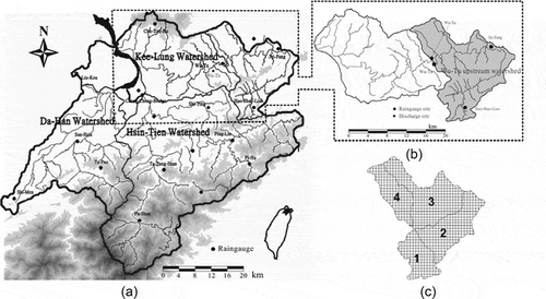
One of the main tributaries of the Tamshui River, which is the third longest river in Taiwan, is the Kee-Lung River (). The Wu-Tu watershed is located upstream of the Kee-Lung River, and was selected as the research site for this study. The Wu-Tu watershed covers nearly 204 km2 and surrounds Taipei City in northern Taiwan (). The mean annual precipitation and runoff of the entire Wu-Tu watershed are 2865 and 2177 mm, respectively. The watershed comprises a large pervious area (high mountains) and a smaller impervious area (watershed downstream), with the majority of the runoff flowing from the pervious area. The rugged topography of the watershed implies that the runoff path-lines are short and steep; in addition, rainfall is non-uniform in time and space. Large floods occur rapidly in the mid-to-downstream reaches of the watershed, causing substantial damage during the summer.
Fig. 1 Map of the Wu-Tu watershed and its four watershed divisions: (a) Tamshui River Basin; (b) Kee-Lung River watershed; and (c) Wu-Tu watershed divisions and their grids.
Data collection
The data used in this study were obtained from 14 raingauges located along the Tamshui River (). Three of the raingauges (Jui-Fang, Wu-Tu and Huo-Shao-Liao) and one discharge site (Wu-Tu) are located within the Wu-Tu watershed (). The study data comprised records for 110 rainfall–runoff events between 1966 and 2008. The degree of urbanization in the research area was gleaned from annual data on population density and imperviousness percentages. This study used data from 64 events to calibrate the model parameters of four watershed divisions by using relative urbanization variables, and employed the remaining events to test the model.
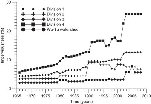
Two urbanization variables (impervious portion and population density) were used as the primary references of urbanization. All rainfall generates surface runoff in impervious areas. The annual imperviousness percentage for each year was obtained based on areas that include streets, roads, railroad lines, highways, roofs, buildings, parking lots, ponds, lakes and waterways. As shown in and , changes in population density and percentage of impervious area were plotted for four divisions of the Wu-Tu watershed between 1966 and 2008. The relationships between these urbanization variables and various other parameters were investigated to examine the hydrological consequences of the urbanization of the Wu-Tu watershed.
Fig. 2 Changes of population density in Wu-Tu watershed and its divisions.
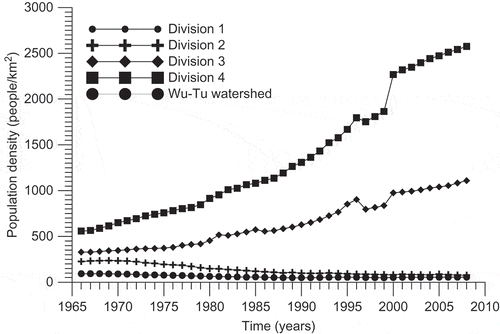
Fig. 3 Changes of imperviousness percentage in Wu-Tu watershed and its divisions.
METHODS
This study applied a semi-distributed parallel-type hydrological model to describe the storm waters of the watershed and its four divisions. The suitability of potential models varies substantially, depending on the level of accuracy desired. Certain calculations, such as the calculation of mean rainfall and rainfall losses on the lumped watershed divisions, are necessary before rainfall–runoff routing can be determined. The univariate geostatistical method (block kriging technology) was used to estimate the areal rainfalls of the watershed and its divisions. The assumed spatially uniform losses of the watershed were calculated using the Ф-index method. The division inputs of the model for an event (i.e. the effective rainfalls of the relevant watershed divisions) represent the mathematical difference between the mean rainfall (per division) and the identical Ф-index computation. The optimal parameters for each division were calibrated using the semi-distributed model with an optimal seeking method and a reliable objective function. The parameters of the watershed divisions were used to observe the urbanization processes in each division.
Block kriging technique
Rainstorms vary greatly in space and time. Traditional methods, such as the Thiessen polygon method, are typically applied to calculate the areal rainfall based on data obtained from raingauge sites located in a watershed. These methods involve employing a linear combination of n raingauge observations Z(xi) located at position xi, and with weights, λi, which can be expressed as follows:
The block kriging method and its variants (Xie et al. Citation2011) also involve using equation (1) to obtain areal and point calculations to estimate the rainfall in a specific area. These methods have numerous applications in various research fields. Typical cases have included raingauge network design (Bastin et al. Citation1984, Cheng et al. Citation2008a), raingauge evaluation (Cheng Citation2011a, Cheng et al. Citation2012), spatial interpolation of rainfall (Goovaerts Citation2000, Syed et al. Citation2003, Basistha et al. Citation2008), and space-time rainfall interpolation (Cheng et al. Citation2007). The primary difference between the kriging method and traditional methods is the weighting computation. The kriging method entails using a semivariogram γ(t,hij) (Lebel and Bastin Citation1985) to illustrate the spatial relationship of a rainfall process and describe rainfall variation in space, and can be expressed as follows:
where hij represents the distance between arbitrary raingauges xi and xj; T denotes the duration of all rainfall events; and p(t, xi) defines the rainfall depth measured by the ith raingauge at the tth period.
The kriging system obtains the optimal weights using a specific semivariogram of rainfall. Thus, the system is obtained by applying Lagrange’s multiplier method, and the point or areal rainfall is calculated using the block kriging system:
where γ(xi,xj) is the semivariogram of raingauge xi and raingauge xj; represents the mean semivariogram of estimated area V and raingauge xi; λj is the weighting of each raingauge;
is the kriging estimated variance; and μ is the Lagrange multiplier.
Bastin et al. (Citation1984) proposed a basic semivariogram for the quick computation of an hourly semivariogram. This model is referred to as the scaled climatological mean semivariogram, and is represented by . This approach can be applied to establish an hourly semivariogram γ(t,hij) by using dimensionless rainfall data obtained from a project basin. Equation (5) shows the relationship between the hourly semivariogram and the scaled climatological mean semivariogram:
where denotes the sill of the semivariogram for period t and is time-variant, a represents the range of the scaled climatological mean semivariogram and is time-invariant, and s(t) denotes the standard deviation of rainfall (mm) for all raingauges for period t. The basic semivariogram is expressed as:
A basic experimental semivariogram can be calculated using equation (6). This semivariogram is always derived from discontinuous point-observations; thus it is not spatially continuous. A realistic application of the block kriging method involves using a semivariogram model to obtain the spatial continuity of rainfall variations.
When applying the block kriging method to estimate the hourly mean rainfall during storm events within specific watershed divisions, the estimated area V in equation (3) must be divided into M grids. Therefore, equation (3) should be revised as follows:
where Vm is the mth grid of the estimated area V, and γ(Vm,xi) represents the semivariogram of the mth grid of Vm and raingauge xi.
Semi-distributed model of a parallel-type cascade of linear reservoirs
The model parameters are derived primarily by acquiring the results of simulated and observed rainfall–runoff events. Several conceptual models and their parameters have originated from the instantaneous unit hydrograph (IUH). This approach is referred to as UH-based modelling. Because UH-based conceptual models typically possess specific definitions for their parameters, any parameters with physical significance can be used to represent the hydrological status of urbanized watersheds during various periods. This study applied a semi-distributed model with a parallel connection to examine the effects of urbanization variables in watershed divisions that displayed a range of characteristics.
A watershed is frequently conceptualized as a multi-cascade reservoir. Reservoirs are typically used to represent rainfall–runoff transformations of a lumped watershed or combined watershed divisions. The general form of the IUH, Un, from the nth cascade of linear reservoirs that has various storage constants kn and period t can be derived as follows (Hsieh and Wang Citation1999):
A lumped watershed system having identical values for linear reservoir storage is a special case of equation (8). The IUH form of a cascade of n linear reservoirs for one SI (Système International) unit of effective rainfall (Nash Citation1957) is calculated as:
where Γ( · ) denotes the gamma function and .
This study considered each watershed division as an independent subsystem. The hydrological status of each subsystem was indicated by two significant parameters: Ko and Kc. The overland storage of a watershed division is represented by Ko, whereas Kc represents the channel storage. A connection from a watershed division to the watershed outlet was constructed using a specific flow path. The Wu-Tu watershed was divided into four subsystems; thus, four parallel flow paths were determined to route the outflow hydrograph at an outlet of the Wu-Tu watershed. The flow paths derived from the four divisions and their downstream channels at the watershed outlet were classified as follows:
Flow Path 1 from watershed division 1:
Flow Path 2 from watershed division 2:
Flow Path 3 from watershed division 3:
Flow Path 4 from watershed division 4:
where oi denotes the overland storage of the ith watershed division, and ci represents channel storage of the ith division.
The total direct runoff at the watershed outlet can be obtained by using the convolution integral, in which the spatially averaged rainfall excess Ii(τ) of each flow path is operated on by Ui(t–τ) and integrated over time t to yield outlet-runoff Q(t). For example, the IUH form of Flow Path 4 derived from equation (8) was determined as follows:
The convolution integral formula was obtained as follows:
where function Ui(t–τ) is the IUH derived from equation (8), the mean rainfall of the lumped divisions was obtained by using the block kriging method, the mean excess values were calculated by subtracting the mean rainfall from the corresponding Ф-index values by assuming spatially uniform losses, and N is the number of divisions in the watershed, set at N = 4 in this study.
CRITERIA FOR EVALUATING MODELS
To measure the suitability of the model parameters for the discussed basin, the following four criteria were used to analyse the goodness of fit.
Coefficient of efficiency
The coefficient of efficiency (CE) is given by:
where Qest(t) denotes the discharge of the simulated hydrograph for period t (m3 s-1), Qobs(t) is the discharge of the observed hydrograph for period t (m3 s-1), and represents the mean discharge of the observed hydrograph (m3 s-1). A CE value close to 1 indicates a good fit.
Error of peak discharge (%)
The error of peak discharge (EQp) is given by:
where Qp,est is the peak discharge of the simulated hydrograph (m3 s-1), and Qp,obs is the peak discharge of the observed hydrograph (m3 s-1).
Error of time to peak
The error of the time for the peak () to arrive is defined as:
where Tp,est denotes the time (h) required for the peak to occur in the simulated hydrographs, and Tp,obs represents the actual time (h) required for the peak to occur in the observed hydrographs.
Error of runoff volume (%)
The error of runoff volume (VER) is given by:
RESULTS AND DISCUSSION
Urbanization variables are frequently used as an index of watershed development. Two examples of these variables are impervious percentage and population density. This study investigated the effects of changes in these two urbanization indices on hydrograph parameters among the four watershed divisions discussed. Identifying the relationships between the urbanization variables and model parameters enables the comparison of space–time continuous variations in the hydrological status of the various watershed divisions. This study examined data that represented parameters from the hydrological model across various periods. The proposed model is a semi-distributed model that can be applied to assess a parallel-type cascade of linear reservoirs. The model is a UH-based conceptual model of watershed divisions, with storage constants Ko and Kc representing separate storages of overland flow and channel flow, respectively.
Mean rainfall and effective rainfall in watershed divisions
A set of discontinuous point-rainfall depths (p(t,x)) during a specific period can be used to generate two-dimensional random fields. Considering n raingauges in a river basin, for each period t, a realization π(t) of the random n vector can be expressed as:
The hourly semivariogram of rainfall is a time function of period t, isotropy, and a time mean form with non-zero and T intervals. Rainfall measurements were obtained from 14 raingauges located along the Tamshui River between 1966 and 2008. The scaled climatological mean semivariogram and its power form () applied for fitting were calculated as follows:
Fig. 4 Climatological mean semivariogram of the research watershed.
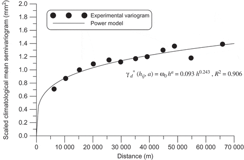
where ω0 denotes the scaled parameter of the scaled climatological mean semivariogram (mm2).
The hourly variance s2(t) of each period t can be calculated using hourly measurements of rainfall that occurred in the identical realization π(t). Based on equations (5) and (17), each hourly semivariogram of rainfall is calculated directly from the hourly variance and scaled climatological mean semivariogram. Equation (7) was subsequently used to obtain the mean rainfall of the entire watershed and its four divisions, based on the hourly semivariograms, data from three raingauges located in the Wu-Tu watershed (Jui-Fang, Wu-Tu and Huo-Shao-Liao), and the grid divisions ().
The lack of records for division-outlet flows implies that rainfall losses in each watershed division could not be measured directly using the principle of volume equilibrium. This principle states that the volume of effective rainfall on a watershed division is equal to that of the direct runoff from the division’s outlet. In other words, the value of rainfall loss is calculated as the difference between rainfall and effective rainfall (or direct runoff). To solve this problem, this study assumed that rainfall losses of rainfall–runoff events were spatially uniformly distributed throughout the entire watershed. These losses were represented by the Ф-index values, which were computed using the mean of measured rainfall and the separated direct runoff of events throughout the entire watershed. The hyetographs of an event over a divided area can be obtained by subtracting the Ф-index constant from the mean hourly rainfall for each division. The event-based effective rainfalls for the four watershed divisions were subsequently used as the inputs of the model for parameter calibration and verification in this study.
Calibration of representative parameters
The direct runoff of a watershed outlet results from a constant separation in baseflow. This study considered the baseflow as groundwater flow before the commencement of rainfall, or the lowest discharge of a rising limb in a streamflow hydrograph (if such discharge was considered a constant). The effective rainfall in the four watershed divisions was calculated using the Ф-index method, under the assumption of spatially uniform losses throughout the watershed.
The division parameters were obtained from 64 samples collected from 110 rainfall–runoff events between 1966 and 2008. The parameter optimization process adopted the shuffled complex evolution algorithm (Duan et al. Citation1993) to obtain values that were representative of each division’s parameters. The parameters that achieved significance were considered adequate to describe the urbanization status of the watershed and its divisions. shows a comparison of simulated and observed runoff hydrographs for the four criteria (CE, EQp, ETp and VER), and shows four cases drawn from the 64 calibrated events.
Fig. 5 Calibration of observed and simulated hydrographs of typhoons and storms.
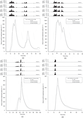
Table 1 Calibrated results of the selected events (dates given as dd-mm-yyyy) with the four evaluation criteria; CE: coefficient of efficiency; EQp: error of peak discharge; ETp: error of time for peak to arrive; VER: error of runoff volume.
This study employed an identical set of four criteria to evaluate the suitability of the proposed model for the discussed watershed. CE is a tool for measuring the performance of a model in hydrology. This study also examined the differences between observed and simulated data for peak quantity and time to peak based on the EQp and ETp, respectively. However, loss values could be calculated only for the entire watershed and not for its divisions, because of unavailable division flow data. Therefore, spatial uniformity of rainfall loss was assumed, and the VER was used to examine the volume equilibrium between the observed and simulated hydrographs of the watershed outlet.
In model calibration, 47 of the 64 rainfall–runoff events obtained CE values greater than 0.9, 16 events obtained values that ranged between 0.8 and 0.9, and only one event (7 June 2001) yielded a value below 0.8. For EQp, 24 cases showed less than 20%, and all remaining cases ranged between 20% and 30%. The five samples that produced approximately 30% were: two storms of 2 January 1984 and 14 August 1984; Typhoon Brenda (13 October 1985); Typhoon Doug (7 August 1994); and the storm of 10 September 2005. For ETp, the values for all events were below 3 h, except for three events (two storms on 23 April 2000 and 11 December 2005, and Typhoon Wipha on 17 September 2007). Only one case (Typhoon Ranani, 12 August 2004) gave VER slightly larger than the VER criterion of 10%. These results show that the simulation values were similar to those that were observed, despite the assumption of spatially uniform losses. The model calibrations for the three previous criteria showed that the parameters of the semi-distributed model adequately represented the watershed conditions during urbanization.
Division parameters and corresponding urbanization variables
In this study, the outlet-hydrograph simulations were evaluated using four criteria. The model parameters that were based on the results of the hydrograph simulations may adequately represent the hydrological conditions of a watershed and its divisions. However, hydrograph parameters are affected not only by urbanization variables but also by weather factors, antecedent moisture conditions and other unknown variables. These unknown variables are referred to as hydrological uncertainties, which frequently result in irregular and unpredictable variations in parameters; thus, applying valid methods is necessary for examining obvious or visible tendencies. Previous methods that involve employing the annual average and optimal interval are used to solve this problem; applying such methods smoothes the disordered, unsystematic variations in division parameters across selected hourly-based cases. The use of the annual average and optimal interval methods has been shown to effectively smooth parameter behaviours for varying degrees of urbanization (Cheng and Wang Citation2002, Huang et al. Citation2008a).
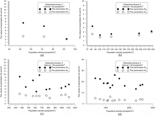
The annual average method was used to obtain annual parameters for watershed divisions that displayed varying degrees of each urbanization case. An annual parameter was computed by obtaining the mean for various calibrated parameters for the same year. By contrast, the optimal interval method was used to estimate a suitable interval based on variations in the model parameters and urbanization variables. The values of these calibrated parameters in the same interval were considered a fixed value; thus, each interval had an identical computation. The optimal magnitude of the interval was finally determined until an obvious tendency between averaged values of model parameters and urbanization variables was observed. The optimal interval method is capable of providing greater clarity on the tendencies of parameters related to urbanization variables, although it is more complex than the annual average method (Huang et al. Citation2012). This study applied the optimal interval method for the correlation analysis to identify changes in parameters that are related to complex urbanization processes in the watershed divisions. shows the correlations between hydrological parameters and imperviousness percentages, and shows the correlations between hydrological parameters and population density.
Fig. 6 Changes of parameter tendencies in relation to imperviousness percentages.
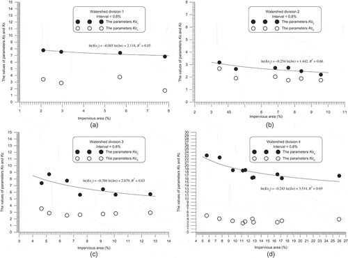
Fig. 7 Changes of parameter tendencies in relation to population densities.
Correlativity of parameter behaviour and urbanization variables
The development of an urban area within a basin is caused by an increase in population density, followed by urbanization. This process is inevitably accompanied by an increase in the number of impervious surfaces that prevent rainwater from being absorbed into the soil surface. The correlations of variables in an urbanizing watershed and its divisions can be analysed through the study of urban hydrology. From this perspective, the simulated results of outlet-hydrographs for the Wu-Tu watershed were completed for parameter calibration. The calibrated parameters indicated the possible effects of urbanization on the rainfall–runoff relationship ( and ). The parameters among the watershed divisions varied according to the degrees of urbanization, and changes in the calibrated parameters were related to urbanization variables, including imperviousness and population density.
Regression analysis was used to further examine the identified relationships between model parameters and urbanization variables in the watershed divisions. Before establishing correlations, the applicability of the urbanization variables and two division parameters was evaluated. This study concerns the applicability of urbanization variables for regular variations of hydrographic parameters. Previous research showed that changes related to urbanization in watershed divisions may be associated with imperviousness or population density (Cheng et al. Citation2010). Relationships may exist between model parameters and urbanization variables. Regarding hydrological effects, the results of this study show that imperviousness directly affected the model simulation because of the separation effect of rainwater, whereas population density was unrelated. As shown in and , the demands of population growth cause increased levels of imperviousness, whereas imperviousness decreased the uncertainly related to a population decrease. These results may be compared with the findings shown in and . The parameter changes related to imperviousness appeared to be more regular than those related to population density. Thus, the hydrological analyses conducted in this study confirm that imperviousness was directly related to the effect of urbanization.
In addition, the applicability of parameters having physical significance was related to the sensitivity of parameter variation for various changes throughout the urbanization process. The proposed parallel-type cascade of linear reservoirs model included two parameters for all watershed divisions: these two parameters represented the physical significance of overland and channel storages. Within a watershed or a division thereof, the area of overland storage is substantially larger than that of the channel storage. Regarding the area contributing to the runoff, the contribution to a watershed outlet of an overland storage must be larger than that of the channel storage, with a significant difference between overland and channel areas. Thus, parameter values representing the channel storage should vary with a greater level of consistency than those describing the overland storage, which is independent of urbanization changes. In response to imperviousness and population, Ko exhibited a greater degree of variance than Kc, as shown in and . Therefore, this study confirmed that the sensitivity to urbanization processes among the four watershed divisions was greater for the significance of overland storage (represented by Ko) than for the significance of channel storage (represented by Kc), regardless of imperviousness percentage or population density.
The two discussed applicability evaluations were completed previously. In the first type, the applicability of imperviousness as a direct variable affecting urbanization in hydrology was evaluated. It was shown that the overland storage parameter exhibited greater sensitivity than the channel storage parameter. This study used imperviousness as a major variable and assumed the channel parameter Kc as constant across each watershed division. The smoothed values of the channel parameters for each division were averaged independently to obtain the respective constants. The average results for the channel parameters in each watershed division are shown in . These fixed values denoted the channel storage of their corresponding divisions, and were independent of the urbanization process. Furthermore, the discrete values of overland division parameter Ko were related separately to the imperviousness percentage of each corresponding division. The natural logarithmic form of regression analysis was used to identify any salient relationships that may be suitable for further study (Cheng Citation2011b).
Table 2 Averaged constants of channel parameters (Kc) and regression results of overland parameters (Ko) related to corresponding imperviousness percentages (Im).
The regression results for the overland parameters that were related to their corresponding imperviousness percentages are shown in and . The coefficient of determination (R2) was used to evaluate whether any power relationships were favourable. The correlations shown in and provided convenient data to examine any changes in overland parameter Ko that were in response to continuous changes in impervious paving.
Relationship verification
The applicability of the urbanization variables and model parameters of two types has been evaluated previously. The imperviousness variable had a direct effect on the hydrograph modelling. Furthermore, Ko was more sensitive to changes in imperviousness than Kc. This study examined the data from 46 rainfall–runoff events that occurred between 2002 and 2008 to further examine reported correlations between Ko and imperviousness percentage.
The baseflow of an event was assumed to be a constant that was derived either from the groundwater flow before the start of rainfall, or from the lowest discharge of a rising limb in a streamflow hydrograph. The mean rainfall of the entire watershed and its divisions were estimated using the block kriging method. This estimation was also based on the assumption in calibration that rainfall loss was spatially uniformly distributed throughout the watershed. The assumed-uniform Ф-index of an hourly-based event was computed according to the entire mean rainfall and outlet direct runoff. For each division, the uniform loss value was subtracted from the mean rainfall to yield the effective rainfall of that division, which allowed the rainfall–runoff model to be verified. The second column of shows that the values of parameter Kc were fixed division constants; the Ko values obtained through regression equations of watershed divisions are also shown. Parameter Ko exhibited non-linear variation with respect to changes in annual imperviousness percentages. The effective rainfall constants Kc and varying parameters Ko were subsequently used to obtain direct runoff estimations. The simulated runoffs were compared with actual runoff observations using the four evaluation criteria.
shows the results for the comparison among 46 cases, and shows plots of four verified cases among the 46 rainfall–runoff events. The CE values for the model verification exceeded 0.70 in all but five events, the EQp values were less than below 25% in all but nine events. The ETp values for all but six events were below 3 h, and the VER values of all examined events were less than 10%.
Fig. 8 Verification between observations and simulations of typhoons and storms.
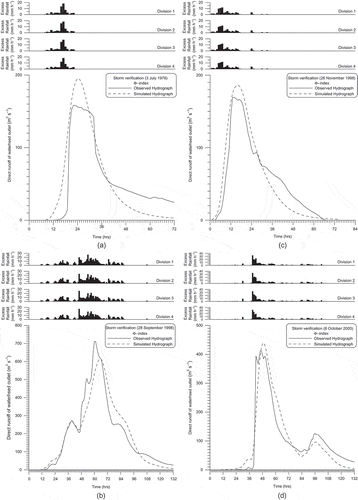
Table 3 Verification results of the selected events with the four evaluation criteria.
Regarding the two discussed model parameters, the variation shown by Ko exhibited a greater level of sensitivity to imperviousness than Kc. Furthermore, the R2 values clearly showed a non-linear correlation between Ko and imperviousness. The verification analysis (based on 46 rainfall–runoff events) also showed a clear correlation between changes in Ko and changes in imperviousness. These results confirm that the equations listed in and reflect the hydrological effect of urbanization. Thus, the impervious area is a major variable indicating the ongoing urbanization of the Wu-Tu watershed. Furthermore, this analysis can be applied further in relevant studies.
CONCLUSIONS
The applicability of urbanization variables and parameter types on watershed divisions were successfully evaluated based on the 64 calibrated and 46 verified events, as well as the integrated approaches. These methods were used to establish the correlation between hydrograph parameters and urbanization variables among four watershed divisions. The approaches employed in this study did not require detailed hydrological data.
The block kriging method was used to estimate the mean rainfall across the watershed and its divisions. Rainfall losses were assumed to have spatially uniform Ф-index values, whereas the distributed effective rainfall within divisions was input to the semi-distributed model of a parallel-type cascade of linear reservoirs. The results for the error of runoff volume criterion (VER) VER show that the principal volume equilibrium was unaffected by the assumption of spatially uniform loss distribution because the simulation volumes were close to those that were actually measured. The remaining three evaluation criteria (CE, EQp and ETp) also confirmed that simulations of the watershed-outlet hydrographs supported the simulation performance well and that the calibrated parameters were reliable for relating them with urbanization variables. Changes in these division parameters resulting from the optimal interval method reflected various degrees of urbanization variables among the divisions.
This study showed that the discussed model parameters consistently exhibited a greater level of sensitivity to changes in imperviousness than to changes in population density. The parameter representing overland storage showed a marked response to changes in imperviousness, whereas the parameter denoting channel storage is independent of the urbanization process. Based on these two confirmations, the averaged values, which were derived from the optimal interval method of the overland parameter, were related to the imperviousness percentages, and the channel parameters were constant within each watershed division. The power linkage provides a method for linking continuous relationships between division parameters and their corresponding imperviousness levels. The verification results for the four discussed evaluation criteria further confirm that the power relationship between the overland parameter and imperviousness responded appropriately to changes in urbanization throughout the watershed divisions. These power equations yielded parameter values that are representative of overland storages for each watershed division based on the observed imperviousness data. Changes in hydrograph characteristics among the watershed divisions were identified to represent various degrees of urbanization among these divisions.
REFERENCES
- Agirre, U., et al., 2005. Application of a unit hydrograph based on subwatershed division and comparison with Nash’s instantaneous unit hydrograph. Catena, 64, 321–332. doi:10.1016/j.catena.2005.08.013.
- Ahmad, M.M., Ghumman, A.R., and Ahmad, S., 2009. Estimation of Clark’s instantaneous unit hydrograph parameters and development of direct surface runoff hydrograph. Water Resources Management, 23, 2417–2435. doi:10.1007/s11269-008-9388-8.
- Arnell, V., 1982. Estimating runoff volumes from urban areas. Journal of the American Water Resources Association, 18 (3), 383–387. doi:10.1111/j.1752-1688.1982.tb00004.x.
- Aronica, G. and Cannarozzo, M., 2000. Studying the hydrological response of urban catchments using a semi-distributed linear non-linear model. Journal of Hydrology, 238, 35–43. doi:10.1016/S0022-1694(00)00311-5.
- Basistha, A., Arya, D.S., and Goel, N.K., 2008. Spatial distribution of rainfall in Indian Himalayas – a case study of Uttarakhand region. Water Resources Management, 22, 1325–1346. doi:10.1007/s11269-007-9228-2.
- Bastin, G., et al., 1984. Optimal estimation of the average areal rainfall and optimal selection of rain Gauge locations. Water Resources Research, 20, 463–470. doi:10.1029/WR020i004p00463.
- Bhadra, A., et al., 2010. Rainfall-runoff modeling: comparison of two approaches with different data requirements. Water Resources Management, 24, 37–62. doi:10.1007/s11269-009-9436-z.
- Boyd, M.J., Bufill, M.C., and Knee, R.M., 1994. Predicting pervious and impervious storm runoff from urban drainage basins. Hydrological Sciences Journal, 39, 321–332. doi:10.1080/02626669409492753.
- Cheng, C.D., et al., 2012. Effects of raingauge distribution on estimation accuracy of areal rainfall. Water Resources Management, 26, 1–20. doi:10.1007/s11269-011-9898-7.
- Cheng, K.S., Lin, Y.C., and Liou, J.J., 2008a. Rain‐gauge network evaluation and augmentation using geostatistics. Hydrological Processes, 22, 2554–2564. doi:10.1002/hyp.6851.
- Cheng, S.J., 2010a. Generation of runoff components from exponential expressions of serial reservoirs. Water Resources Management, 24, 3561–3590. doi:10.1007/s11269-010-9621-0.
- Cheng, S.J., 2010b. Hydrograph characteristics of quick and slow runoffs of a watershed outlet, Taiwan. Hydrological Processes, 24, 2851–2870. doi:10.1002/hyp.7699.
- Cheng, S.J., 2010c. Inferring hydrograph components from rainfall and streamflow records using a kriging method-based linear cascade reservoir model. Journal of the American Water Resources Association, 46, 1171–1191. doi:10.1111/j.1752-1688.2010.00484.x.
- Cheng, S.J., 2011a. Raingauge significance evaluation based on mean hyetographs. Natural Hazards, 56 (3), 767–784. doi:10.1007/s11069-010-9589-3.
- Cheng, S.J., 2011b. The best relationship between lumped hydrograph parameters and urbanized factors. Natural Hazards, 56 (3), 853–867. doi:10.1007/s11069-010-9596-4.
- Cheng, S.J., Hsieh, H.H., and Wang, Y.M., 2007. Geostatistical interpolation of space-time rainfall on Tamshui River Basin, Taiwan. Hydrological Processes, 21, 3136–3145. doi:10.1002/hyp.6535.
- Cheng, S.J., Lee, C.F., and Lee, J.H., 2010. Effects of urbanization factors on model parameters. Water Resources Management, 24, 775–794. doi:10.1007/s11269-009-9471-9.
- Cheng, S.J., et al., 2008b. The storage potential of different surface coverings for various scale storms on Wu-Tu watershed, Taiwan. Natural Hazards, 44, 129–146. doi:10.1007/s11069-007-9146-x.
- Cheng, S.J. and Wang, R.Y., 2002. An approach for evaluating the hydrological effects of urbanization and its application. Hydrological Processes, 16, 1403–1418. doi:10.1002/hyp.350.
- Clarke, R.T., 1973. A review of some mathematical models used in hydrology, with observations on their calibration and use. Journal of Hydrology, 19, 1–20. doi:10.1016/0022-1694(73)90089-9.
- Dooge, J.C.I., 1959. A general theory of the unit hydrograph. Journal of Geophysical Research, 64, 241–256. doi:10.1029/JZ064i002p00241.
- Duan, Q., Gupta, V.K., and Sorooshian, S., 1993. Shuffled complex evolution approach for effective and efficient global minimization. Journal of Optimization Theory and Applications, 76, 501–521. doi:10.1007/BF00939380.
- Franchini, M. and O’Connell, P.E., 1996. An analysis of the dynamic component of the geomorphologic instantaneous unit hydrograph. Journal of Hydrology, 175, 407–428. doi:10.1016/S0022-1694(96)80018-7.
- Goovaerts, P., 2000. Geostatistical approaches for incorporating elevation into the spatial interpolation of rainfall. Journal of Hydrology, 228, 113–129. doi:10.1016/S0022-1694(00)00144-X.
- Gremillion, P., Gonyeau, A., and Wanielista, M., 2000. Application of alternative hydrograph separation models to detect changes in flow paths in a watershed undergoing urban development. Hydrological Processes, 14, 1485–1501. doi:10.1002/1099-1085(20000615)14:8<1485::AID-HYP988>3.0.CO;2-1.
- Hsieh, L.S. and Wang, R.Y., 1999. A semi-distributed parallel-type linear reservoir rainfall-runoff model and its application in Taiwan. Hydrological Processes, 13, 1247–1268. doi:10.1002/(SICI)1099-1085(19990615)13:8<1247::AID-HYP807>3.0.CO;2-W.
- Huang, H.J., et al., 2008a. Effect of growing watershed imperviousness on hydrograph parameters and peak discharge. Hydrological Processes, 22, 2075–2085. doi:10.1002/hyp.6807.
- Huang, S.Y., et al., 2008b. Identifying peak-imperviousness-recurrence relationships on a growing-impervious watershed, Taiwan. Journal of Hydrology, 362, 320–336. doi:10.1016/j.jhydrol.2008.09.002.
- Huang, S.Y., et al., 2012. Identifying hydrograph parameters and their relationships to urbanization variables. Hydrological Sciences Journal, 57 (1), 144–161. doi:10.1080/02626667.2011.637044.
- Jin, C.X., 1992. A deterministic gamma-type geomorphologic instantaneous unit hydrograph based on path types. Water Resources Research, 28, 479–486. doi:10.1029/91WR02577.
- Junil, P., Kang, I.S., and Singh, V.P., 1999. Comparison of simple runoff models used in Korea for small watersheds. Hydrological Processes, 13, 1527–1540. doi:10.1002/(SICI)1099-1085(199907)13:10<1527::AID-HYP804>3.0.CO;2-A.
- Kang, I.S., Park, J.I., and Singh, V.P., 1998. Effect of urbanization on runoff characteristics of the On-Cheon Stream Watershed in Pusan, Korea. Hydrological Processes, 12, 351–363. doi:10.1002/(SICI)1099-1085(199802)12:2<351::AID-HYP569>3.0.CO;2-O.
- Kliment, Z. and Matoušková, M., 2009. Runoff changes in the Šumava Mountains (Black Forest) and the Foothill Regions: extent of influence by human impact and climate Change. Water Resources Management, 23, 1813–1834. doi:10.1007/s11269-008-9353-6.
- Krug, W.R., 1996. Simulation of temporal changes in rainfall-runoff characteristics, coon creek basin, Wisconsin. Journal of the American Water Resources Association, 32 (4), 745–752. doi:10.1111/j.1752-1688.1996.tb03471.x.
- Lebel, T. and Bastin, G., 1985. Variogram identification by the mean-squared interpolation error method with application to hydrologic fields. Journal of Hydrology, 77, 31–56. doi:10.1016/0022-1694(85)90196-9.
- Li, Y.J., et al., 2012. Relating hydrograph components to rainfall and streamflow: a case study from northern Taiwan. Hydrological Sciences Journal. doi:10.1080/02626667.2012.685171.
- Liu, A., Goonetilleke, A., and Egodawatta, P., 2012. Inadequacy of land use and impervious area fraction for determining urban stormwater quality. Water Resources Management, 26, 2259–2265. doi:10.1007/s11269-012-0014-4.
- Melone, F., Corradini, C., and Singh, V.P., 1998. Simulation of the direct runoff hydrograph at basin outlet. Hydrological Processes, 12, 769–779. doi:10.1002/(SICI)1099-1085(19980430)12:5<769::AID-HYP624>3.0.CO;2-K.
- Nash, J.E., 1957. The form of the instantaneous unit hydrograph. IAHS Publications, 45, 112–121.
- Nourani, V., Singh, V.P., and Delafrouz, H., 2009. Three geomorphological rainfall-runoff models based on the linear reservoir concept. Catena, 76, 206–214. doi:10.1016/j.catena.2008.11.008.
- O’Connell, P.E. and Todini, E., 1996. Modelling of rainfall, flow and mass transport in hydrological systems: an overview. Journal of Hydrology, 175, 3–16. doi:10.1016/S0022-1694(96)80003-5.
- Olivera, F. and DeFee, B.B., 2007. Urbanization and its effect on runoff in the Whiteoak Bayou watershed, Texas. JAWRA Journal of the American Water Resources Association, 43, 170–182. doi:10.1111/j.1752-1688.2007.00014.x.
- Rodriguez, F., Andrieu, H., and Creutin, J.D., 2003. Creutin Surface runoff in urban catchments: morphological identification of unit hydrographs from urban databanks. Journal of Hydrology, 283, 146–168. doi:10.1016/S0022-1694(03)00246-4.
- Simmons, D.L. and Reynolds, R.J., 1982. Effects of urbanization on base flow of selected South-Shore Streams, Long Island, New York. Journal of the American Water Resources Association, 18, 797–805. doi:10.1111/j.1752-1688.1982.tb00075.x.
- Syed, K.H., et al., 2003. Spatial characteristics of thunderstorm rainfall fields and their relation to runoff. Journal of Hydrology, 271, 1–21. doi:10.1016/S0022-1694(02)00311-6.
- Xie, H., et al., 2011. Performance evaluation of interpolation methods for incorporating rain gauge measurements into NEXRAD precipitation data: a case study in the Upper Guadalupe River Basin. Hydrological Processes, 25, 3711–3720. doi:10.1002/hyp.8096.
- Yue, S. and Hashino, M., 2000. Unit hydrographs to model quick and slow runoff components of streamflow. Journal of Hydrology, 227, 195–206. doi:10.1016/S0022-1694(99)00185-7.