
Abstract
On the slopes of the embankment of the Al-Khod groundwater recharge–flood protection dam (Oman), a band of scrub vegetation community emerged after torrential rains and temporary filling of the dam reservoir. Species composition differs markedly on both sides of the embankment, with many exotics found on the reservoir side and more typical gravel-desert species on the outside. Hydro-ecologically, the vegetation is interpreted as the footprint of a temporary storage of water, which is a small-sized groundwater mound within the permeable shoulder of the levee. The levee, as an anthropogenic landform, induces a U-turn (gravitational slumping–lateral seepage–transpirational moisture ascent) topology of seepage. The Lembke method of successive variations of steady states is used in modelling the water table dynamics. In the early stage of the mound decay, outflow through a seepage face of the shoulder is modelled by the Barenblatt slumping parabola of the phreatic-zone part of the flow domain, which is perfectly matched with the Youngs exact solution for a purely horizontal flow through a porous wedge. At the stitching cross-section, the flow rates and saturated depths in the two zones coincide. The late stage of mound evolution is characterized by transpiration by the plant roots projected onto a shrinking free surface, with the Barenblatt and Youngs solutions conjugated but without the outcrop of the saturated mound on the levee slope. Ordinary differential equations for the sliding or descending locus of the intersection of the parabola and the triangle hypotenuse are integrated in a closed form or by the Runge-Kutta method. The dwindling saturated volume and the rate of drainage are obtained. They can be used in assessments of the hydro-ecological sustainability of slope-rooted shrubs (vegetation survival between rare rainfall episodes).
Editor D. Koutsoyiannis; Associate editor A. Porporato
Résumé
Sur les pentes de la digue du barrage Al-Khod (Oman), construit pour la recharge de nappe et la protection contre les inondations, une bande de végétation arbustive est apparue après des pluies torrentielles et le remplissage temporaire de la retenue du barrage. La composition végétale diffère nettement des deux côtés de la digue, avec de nombreuses espèces exotiques sur le bord du réservoir et des espèces plus typiques des déserts caillouteux à l’extérieur. Hydro-écologiquement, la végétation est interprétée comme l’empreinte d’un stockage temporaire de l’eau, c’est-à-dire un petitdôme piézométriquedans un épaulement perméable de la digue. La digue, relief anthropique, induit une percolation en U (descente gravitationnelle-cheminement latéral-remontée par transpiration). La méthode de Lembke (1886) de successions d’états permanents est utilisée pour modéliser la dynamique de la nappe phréatique. Au stade précoce de baisse du dôme, le flux sortantau travers d’une surface de percolation de l’épaulement est modélisé par la parabole de décroissance de Barenblatt dans la partie phréatique, ce qui correspond parfaitement à la solution exacte de Youngs (1974) pour un écoulement purement horizontal à travers un coin poreux. Au raccord des sections, les débits et les épaisseurs saturées dans les deux zones coïncident. La dernière étape de l’évolution du dôme est caractérisée par la transpiration par les racines des plantes projetée sur une surface libre décroissante, avec les solutions de Barenblatt et Youngs conjuguées mais sans affleurement du dôme saturé sur la pente de la digue. Des équations différentielles ordinaires pour le glissement ou la descente du lieu de l’intersection de la parabole et de l’hypoténuse du triangle sont intégrées par la méthode de Runge-Kutta ou une forme proche. On obtient ainsi la perte de volume saturé et le taux de drainage. Ils peuvent être utilisés pour évaluer la durabilité hydroécologique d’arbustes enracinés sur la pente (survie de la végétation entre les rares épisodes de précipitation).
“Boulder-strewn hillslopes have received little attention from ecologists. However, the unique features of boulder fields on hillslope which, in some instances, approach mini-oases, deserve attention.”
Walter Whitford (in Ecology of Desert Systems, 2002)
“The more one seeks to rise into height and light, the more vigorously do ones roots struggle earthward, downward, into the dark, the deep – into evil.”
Friedrich Nietzsche (Thus Spoke Zarathustra, 1885, “On the Tree on the Mountain”)
INTRODUCTION AND HYDRO-ECOLOGICAL MOTIVATION
One of the tasks of ecohydrology is to integrate water resources management, hydrology and the response of ecosystems to natural and anthropogenically alternating realizations of the hydrological cycle. This requires an interdisciplinary approach, which ideally amalgamates the holistic (Darwinian) and reductionist (Newtonian) techniques of study of the bio-hydro system, also called a Platonian superorganism (Zalewski Citation2000). Determination and prediction of spatial patterns of vegetation linked with the spatial complexity of water (moisture), especially in the root zone, is a component of ecohydrology where the botany–hydrology–soil physics nexus emerges. These ‘green’ and ‘blue’ patterns transform in time within a given (or also changing) geomorphological setting (see, e.g. Wilcox Citation2010). If Newtonian mechanics or Volterra-type ecodynamics are used in 4-D simulations of the water–biome interaction, solving of the boundary-value problems (BVP) is required. Then climate–plant determined initial and ‘forcing’ conditions (Loague et al. Citation2006, Wainwright et al. Citation2011) are involved.
According to Porporato and Rodrigues-Iturbe (Citation2002), ecohydrology is the study of the mutual interaction between the hydrological cycle and ecosystems, with a special focus on fluctuations of the cycle components intertwined with the network of dynamic links within the climate–soil–vegetation system in arid zones, where water is scarce and its appearance is intermittent. Similarly, Noy-Meir (Citation1973) emphasized that ecohydrology of an arid and hyper-arid environment is characterized by “infrequent, discrete, and largely unpredictable water inputs”. The pulses of precipitation and strong seasonal variations of the moisture content in the topsoil are sometimes accompanied by the proximity of the plant roots to a temporarily stable source of groundwater from a water table if a shallow unconfined aquifer/capillary fringe is present (Brown Citation2002, Guswa et al. Citation2002, Newman et al. Citation2006, Lubczynski Citation2009). This vertical zonation of the soil/rock-contained water, available to the roots, is juxtaposed with a lateral hydrological variability in riparian systems or in hillslopes with dipping water tables. In these soil massifs with both vertical and lateral zonation of moisture conditions, a surface water body (e.g. lake or river) creates hydro-ecologically favourable localized (from a planar viewpoint) spots (Williams et al. Citation2006).
The functional and structural connectivity of the moving surface water, groundwater, soil moisture and flora, the time-evolution of this connectivity with different frequencies, durations and intensities of hydrological impacts is—in ecohydrological ‘holistic’ studies—sometimes alienated with an ‘engineering’ approach. The latter is considered as disturbing the homeostasis of a biosystem. We advocate an opposing concept: civil engineering and ecohydrology of water-limited environments can be allied rather than antagonized in fulfilling hydrotechnical tasks (in our case of an Omani recharge dam: flood control, water supply to farmers and alleviating sea water intrusion in coastal aquifers) and ecological ‘collateral benefits’ (increasing biodiversity and enriching the aesthetic value in areas adjacent to hydrotechncial constructions).
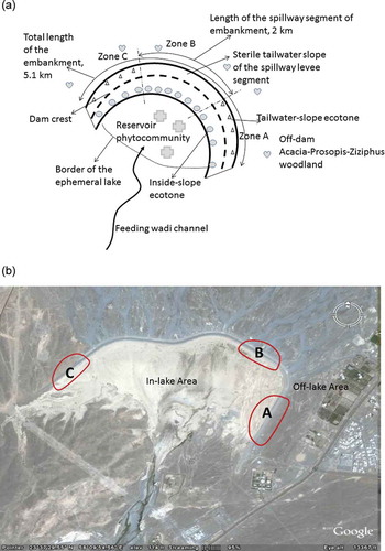
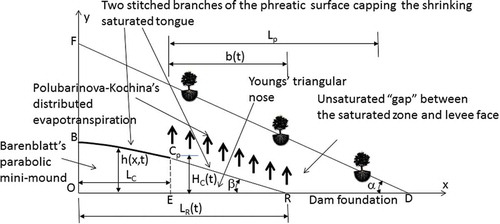
We present both a holistic and reductionist study of a specific structure (an earth dam). The dam operates under regimes of infrequent flooding that has created two unique ecotones associated with the lake-side and tailwater slopes of the dam embankment, and two larger phytocommunities (in the lake and off-lake areas). shows a schematic areal view of the dam (not to scale) with crosses, hearts, triangles and circles indicating the plants inside the dam reservoir, outside the dam (background vegetation), on the lake-side and tailwater slopes, respectively. The Google Earth image in shows the study area. The ecotones represent a unique desert-hillslope plant assemblage, which we surmise to be controlled by interception of the in-dam water by the plant roots.
Fig. 1 (a) Schematic plan diagram of the study area (not to scale); (b) an aerial view of the dam area with demarcation of three major dam segments where the ecotones and phytocommunities were observed.
Although the complex interaction between groundwater, soil moisture and desert vegetation is well-documented (e.g. Noy-Meir Citation1973, Brown Citation1974, Warner Citation2004), to the best of our knowledge, nobody has studied the hydro-ecology of plants in relation to the construction of dams whose reservoirs are only temporarily filled with water. Moreover, a common spatial scale of study in hydro-ecology is a catchment, a part of a river basin or a relatively long section of a river (wadi) channel, i.e. a range from to
metres. In our study we do the ‘first basic level’ of Porporato and Rodrigues-Iturbe’s (Citation2002) spatial analysis (few metres of the dam half-width), with an essentially transient phreatic surface inside the dam body and plant response to its dynamics as determined by flood events and post-flood slumping and dwindling of the saturated zone within the dam shoulder. In relatively large-scale hydrological studies (Williams et al. Citation2006), the water table is often described as simply ‘deep’ or ‘shallow’. In our case, small variations of the locus of the phreatic surface in the dam body are crucial for the ecotones in and should be quantified (modelled) with an accuracy of metres or even tens of centimetres. Porporato and Rodrigues-Iturbe (Citation2002) pointed out that the complex dynamics of soil–vegetation systems in ecohydrology calls for adequate simplifications in theoretical analysis. For this purpose, we selected the method of Lembke (Citation1886), which approximates a transient phreatic surface by a relatively simple analytical curve, e.g. a parabola, whose coefficients are found from mass-balance conditions. Commonly, Dupuit’s parabolas or infiltration ellipses are used. Below, we follow the Strack (Citation1989) protocol and decouple the flow domain under a slumping phreatic surface into a Barenblatt parabola and Youngs triangle.
The paper is organized as follows: First, we describe the hydraulic structure and study area. Second, we describe the vegetation, in particular, the phytocommunity on the levee slopes. Third, we simulate water dynamics within our porous embankment during the early stage of seepage with an outcropping water table. Fourth, the late seepage regime is simulated, when the saturated mound is hidden in the levee and the slope plants are the only evidence of the mound’s existence.
AL-KHOD DAM IN OMAN
In Oman, two major floods, caused by the June 2007 Gonu and June 2010 Phet cyclones, inflicted enormous damage (the former estimated at more than US$3 billion). Most dams withstood the flood but they spilled over, i.e. the reservoir capacity was insufficient. After these floods the Omani government invested heavily in the design and building of new flood protection and groundwater recharge dams, in particular, the Wadi Adai cascade of eight dams and Al-Khod Dam (all in the vicinity of Muscat, the capital), as well as in the upgrading of existing ones (43 as of 2013).
We have studied the Al-Khod Dam since 1998, in particular, the soil infiltration properties of the reservoir bed and adjacent areas (Kacimov et al. Citation2010, Citation2014, Al-Ismaily et al. Citation2013a, Citation2013b). According to the International Commission on Large Dams (ICOLD; http://www.icold-cigb.org/) classification, the Omani dams belong to the class of small dams, e.g. the Wadi Amerat and Al-Khod dams have embankment heights of 22 and 12 m (maximum) but their crest arc-lengths are huge. The Al-Khod Dam length is 5.1 km (see the dashed line in , which depicts the dam crest). The only feasible economic option for a levee of such length is earth-filling with a cheap local alluvial topsoil and sediments. Such filling is, however, very permeable (the saturated hydraulic conductivity k ranges 100–101 m/d).
A typical vertical cross-section of the dam embankment is shown in . The embankment of this so-called ‘zone-type fill dam’ has a total volume of 1 × 10⁶ m3, initial (1985) reservoir area of 3.2 km2 and the original storage capacity of the reservoir at the time of construction in 1985 was 11.6 × 10⁶ m3 (Ministry of Water Resources Citation1999). During the last 27 years, siltation and periodic silt scraping have significantly changed both the reservoir volume and the microtopography of its bed. Consequently, the dotted line in , demarcating the lake area from the upstream side, is actually not fixed even for a specified volume of flash-flood water delivered to the reservoir by the feeding wadi.
We divided the study area into three zones: A, B and C (). The borders of Zone B coincide with those of the spillway section of the levee (length: 2 km). Here the height of the embankment is constant. The rest of the levee—zones A and C (total length: 3.1 km) on the left and right flanks of Zone B—has a crest height Hc that decreases from 11 m to 0 m. The lake-side levee shoulder has a slope α of 30°.
The headwaters of the Al-Khod Wadi feeding the dam (and prior to 1985 discharging to the Gulf of Oman) are on the east-facing slopes of Jabel Nakhl and northeast-facing slopes of the Jabel Hajar range. The catchment area is 1635 km2. Details on the geology and hydrogeology of the study area have been reported by Abdalla and Al-Abri (Citation2011).
After a rare flash-flood episode, the dam lake is filled (sometimes partially) within 1–2 days or even a few hours. Water in the reservoir is normally retained for not more than two weeks after a flood event. Eleven sluice gates drain the reservoir through culverts. Consequently, for most of the year, except for a few remaining pools (depressions in the lake area detain water from draining through the gates), there is no water in the lake. Water stays for several months in these pools, depending on the degree of the lake filling by the flash flood and ambient weather conditions. The pools have no contact with the embankment and have no effect on it.
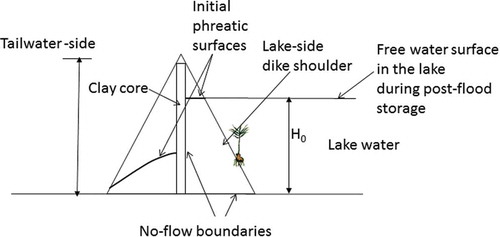
The core of the dam is made of clay or concrete (). This core is designed to withstand the hydrostatic pressure of water from the reservoir side, because, as we have mentioned, the shoulders are made of a very permeable material. Therefore, the core, aimed at preventing cross-seepage through the embankment body when the reservoir is filled with flood water, creates hydraulic disconnection between the two shoulders. Therefore, the saturated zones and their corresponding phreatic surfaces (see ) evolve independently after a flood/rainfall event. Both slopes of the dam are stabilized by rip-rap, with boulders on the inside slope and cobbles on the outside.
Fig. 2 Vertical cross-section of the embankment with two shoulders (tail-water side and lake-side).
The climate of the study area is arid (Shahin Citation2007), with an average rainfall of 100 mm/year, evaporation of more than 2000 mm/year, annual average temperature of 31°C, average relative humidity of 49%, and the daily mean global radiation flux exceeds 600 W/m2 in April–August. However, the weather conditions in the three zones of are identical, with a minor effect of the different exposure of the levee slopes to solar radiation. The arid nature of the climate is underlined by the fact that all agricultural crops in the nearby farms are under heavy irrigation norms throughout the whole year.
The regional water table in the vicinity of the dam is normally 10–15 m deep below the ground surface and, although it quickly rises after a major rainfall event and infiltration from the water-filled lake area, it recedes rapidly owing to the high transmissivity of the recent-alluvium aquifer (Abdalla and Al-Abri Citation2011).
During the relatively dry period of 1999–2002 (see rainfall data in Abdalla and Al-Abri Citation2011), the Omani Ministry of Water Resources even considered reducing the average of annual precipitation data in the study area from 100 to 85 mm/year. At that time we observed only limited scrub vegetation in the dam-lake area (pre-dam phreatophytes were, of course, destroyed during the dam construction in 1985). The embankment slopes were virtually sterile.
The floristic situation changed markedly after Gonu and Phet (and other less intensive flash floods) during the wet period from 2003 to 2012. In the winter of 2010/11, we observed a relatively diverse (but patterned) population of shrubs and herbaceous species rooted on the fine silt substrate of the lake bottom. What surprised us even more and initiated this ecohydrological study, was a strip of scrub developed on the slopes of the levee. Despite the obstruction of the rip-rap boulders, a strip of plants had established on both slopes of the embankment, as depicted in . On the lake side of the levee the vegetation of the corresponding band is stronger than on the tailwater side, as explained later.
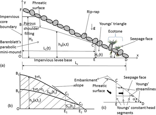
Fig. 3 (a) Vertical cross-section of the tail-water shoulder with a phreatic surface outcropping through the seepage face (early period of recession); (b) the successively receding phreatic surface; and (c) the flow net in the Youngs triangle.
Physical patchiness of vegetation in arid climates can be attributed to microtopography (mini-dunes, ruts, etc.) (Brown and Porembski Citation1997, Citation1998, Whitford Citation2002), i.e. non-flat soil surface, that induces not only a transient, but essentially 3-D water-moisture motion controlled by this topography. Therefore, the observed band of plants is, in our opinion, the footprint of a pocket of water stored in the shoulders of the levee as a temporary, decaying groundwater mini-mound. We surmise that the plant roots tap the corresponding in-shoulder saturated soil. The saturated zone in the levee dwindles after the reservoir is emptied, but still remains sufficiently large to feed the roots.
The proliferation of vegetation on outseeping hillslopes and porous river banks (riparian ecosystems), subject to periodic fluctuations of the phreatic surface outcropping on the slope, is well-known (e.g. Naiman et al. Citation2005). However, the ability of a relatively small-sized porous compartment of the levee shoulder in – to maintain the vegetation band was flummoxing, until we understood the dynamics of the levee-hosted ‘aquifer’. In groundwater hydrology such a subsurface water body is called a ‘perched aquifer’, and is separated from the main (in our case, 10–15 m deep) aquifer by a thick vadose zone. The phreatic surface B–C of the in-levee mound in is essentially non-stationary. The geotechnically promoted mini-oases in –, have not been studied before, neither by hydrologists/civil engineers nor by botanists (see the epigraph).
In this paper we explain how the edaphic (conductivity k and soil porosity m) and anthropogenic landform factors (α and the levee size Ls in ) control B–C and apparently the water uptake by roots. Similar problems arise in hillslope ecohydrology, where water dynamics and its relationship with the typology and spatial patterning of vegetation have been studied on a larger scale (e.g. Ridofli et al. Citation2003, Ludwig et al. Citation2005).
DESCRIPTION OF VEGETATION
Our dam is located on a typical lowland gravel-plain ecosystem in northern Oman, which is characterized by a very open woodland community dominated by the small tree Acacia tortilis. This species attains a maximum height of about 4–5 m. Common accompanying species include the semi-succulent small shrub Euphorbia larica, which, apart from Acacia, is the most conspicuous species on the plains, the perennial herbs Crotalaria aegyptiaca, Ochradenus aucheri and Taverniera glabra (the latter often a biennial), as well as the perennial grasses Aristida adscensionis and Dicanthium foveolatum. Two prostrate perennial spiny herbs, Blepharis ciliaris and Fagonia bruguieri are also fairly widespread. This type of vegetation has been described as Acacia-Prosopis-Ziziphus woodland by Ghazanfar (Citation1998), and is widespread throughout northern Oman, extending into the eastern part of the UAE (Brown and Sakkir Citation2004).
Acacia is a phreatophyte, albeit one that exploits water in the upper surface layers. As a consequence, this tree, along with much of the accompanying vegetation, displays a typical contracted pattern (‘mode contracté’, Monod Citation1954), being concentrated along the edges of shallow drainage channels that form a network across the plains. Le Houérou (Citation2005) noted that contracted vegetation is a specific feature of true deserts with a mean annual rainfall usually below 100 mm, and is characteristic of desert pavements and gravel plains. Perennial vegetation cover is generally sparse, on the plain proper less than about 5%, although up to 25% along sections of the drainage channels.
Within the lake area, which is subject to major disturbance in the form of occasional flooding, a very different type of vegetation has developed that will be described in more detail elsewhere. In brief, this vegetation is characterized primarily by anthropogenic assemblages in which various species predominate. Many of these can be regarded as typical indicators of disturbance. Remarkably, several of the more common species are non-native exotics, including the ornamental Parkinsonia aculeata, a native of the southwestern USA, Central America and parts of South America, Prosopis juliflora (mesquite, a noxious invasive, introduced from Central America) and Ricinus communis, the highly toxic castor oil plant, a species that forms dense stands locally, especially on thick silt deposits. Of the native species, the most common are Indigofera oblongifolia, a legume that is widespread on the reservoir floor, forming very large hemispherical shrubs up to 1 m in height, but not observed outside of the embankment-encircled area, and the prostrate phreatophyte Citrullus colocynthis. Both are somewhat characteristic of disturbed areas, with the former for instance found on abandoned fields in the adjacent UAE (Jongbloed Citation2003), and the latter frequently occurring in depressions that are temporally inundated. Calotropis procera (Sodom’s apple), a medium sized, straggling large-leaved shrub is a typical indicator of disturbance in the region and occurs scattered on silt in the reservoir area. In this zone, the native Acacia tortilis is conspicuous by its absence, in contrast to the situation on the surrounding plains. This species appears to be very sensitive to inundation. Personal observations from a gravel plain in the UAE showed that after a dam burst its banks, causing temporary flooding of a section of the adjacent plain, all individuals of Acacia tortilis were killed very quickly. This is presumably due to the fact that waterlogged soils become oxygen-depleted within 1–2 days (Barrett-Lennard Citation2002). Interestingly, a single individual of Acacia gerrardii was found in the reservoir of the Al-Khod Dam, a species that in Oman is otherwise restricted to mountain habitats above about 1000 m. It seems that seeds of this tree were washed down from higher altitudes of the Hajar mountains in the flood waters of the wadi, whose geomorphological and hydrological features are common for the whole region (e.g. Sén Citation2008). Citrullus is a typical water-spender, transpiring huge amounts of water to cool its remarkably large leaves (Lange Citation1959). Lange (Citation1959) reported that a temperature depression of as much as 15.3°C compared with ambient air temperatures could be achieved by Citrullus. This loss of water requires that the plants have permanent access to soil-moisture and, to ensure this, the plants develop a long taproot with a fibrous lateral root system located just above the water table (Althawadi and Grace Citation1986). From Kuwait it is well-known that its transpirative cooling mechanism is so effective that it is exploited by desert larks, which stand or sit on the plants with their wings slightly open during periods of intense solar irradiation, as described in detail by Cowan and Brown (Citation2001) and Brown (Citation2009).
Vegetation on the inside wall of the embankment shows a very characteristic banding, at least along many sections. At the foot of the levee, a dense strip of Ricinus communis is developed about 4–5 m in width, and with cover values up to 90%. It colonizes the silt that has been deposited there, covering the boulders. The seeds of this species are presumably dependent on longer exposure to moisture to ensure germination and vigorous growth. Further up the embankment is a narrow strip, 1–2 m in width, largely devoid of plant life, and then, about half way up the levee on boulders retaining detritus deposited by the receding flood waters, a band of woody vegetation. The chief tree species at this location is the ornamental Parkinsonia aculeata, but the invasive Prosopis juliflora is also present, as are a few scattered individuals of the native phreatophyte Ziziphus spina-christi. It is well-known from the New World that seeds of Parkinsonia are often dispersed by water. This woody vegetation, which forms a band of up to about 5 m in width, is accompanied locally by fairly dense growth of the perennial grass Cenchrus ciliaris. Total perennial vegetation cover in this strip varies according to location from 5% to 25%. Towards the apex of the embankment, much coarse detritus, including date palm trunks and leaves, has been deposited, indicating the maximum height of the flood water. On the outside wall of the embankment, a very different type of vegetation occurs. A banding of vegetation is also visible there, but it is not as pronounced as on the inside wall. At the toe of the embankment, a narrow strip of more dense, low vegetation occurs, about 0.5–1 m in width, which is dominated by the short-lived grass Dicanthium foveolatum. This species is typical of the adjacent desert plain, as are the occasionally interspersed associates Blepharis ciliaris and Fagonia bruguieri.
The cobbles of the embankment slope support a very open vegetation, in which two native species predominate, Leptadenia pyrotechnica and Physorrhynchus chamaerapistrum. The first is an aphyllous shrub attaining a maximum height of 4–5 m on the slope. Although a native to the region as a whole, and a fairly widespread sand-binder in Oman, it is notably more common in disturbed anthropogenic habitats, and is for instance abundant on urban wasteland in the vicinity of the dam. Initial colonization of the cobbles probably occurred via seed dispersed by the wind. The seeds have an apical tuft of dense hairs, up to 3 cm in length, which aid anemochory. Judging by the present population structure, characterized by a few older plants accompanied by a larger number of smaller, younger plants, it seems that once a few individuals had become successfully established, they produced seed to give rise to a host of offspring. Leptadenia is known as a deep-rooted species (Sen Citation1968), and so would be able to take advantage of any water stored deep down within the embankment. The absence of leaves in this species (the few that are developed are shed at a very early stage) means that photosynthesis and transpiration are carried out almost exclusively by the whip-like stems. Physorrhynchus chamaerapistrum, in contrast, is a very large-leafed, woody-based perennial herb. With its rather large indehiscent siliculae, which act as the unit of dispersal, the diaspores of this species are not obviously amenable to anemochory, and so other vectors, possibly birds, must play a role. It seems there is very little general information on the ecology of this species, which is fairly widespread on rocky substrates in the general vicinity. However, due to the presence of large leaves throughout the year, it can be assumed that this species must also have continuous access to a subterranean water supply, presumably by virtue of a deep taproot, especially as it is also able to flower very early in the season before the onset of the first rains.
EARLY STAGE OF SEEPAGE IN THE LEVEE
The in-levee water compartment feeding the vegetation bands described in the previous section, will be now analysed with the objective of linking the existence of the observed flora with an inherently transient phreatic surface. In this section we ignore the interception of water by roots.
Conceptual model of two subdomains
The peculiarity (geometrical size and time scale of evolution) of our hydrological entity requires a special model, different from standard mesh-based packages. We employ the Lembke (Citation1886) analytical method of successive variations of steady states, which in the pre-computer age was a popular analytical tool among Soviet groundwater hydrologists and reservoir engineers (see, e.g. Leibenzon Citation1934, Charny Citation1949). They used the method in studies of porous media flows with a transient sharp-interface (e.g. oil–water contact). Mathematically, the method reduces a partial differential equation (PDE) (e.g. the Boussinesq equation in groundwater hydrology) to an ordinary differential equation (ODE). Barenblatt et al. (Citation1990) extended the method by considering integral relationships for phreatic surfaces approximated by general series expansions and arrived at a system of ODEs for the series coefficients. The Western vestiges (see e.g. Tzimopoulos Citation1989) of Lembke’s legacy are now, unfortunately, decaying.
The Lembke method assumes that at each fixed time moment, seepage is steady state and the corresponding flow rate at the outlet of the flow domain is calculated. Transiency is introduced through evaluation of the saturated area and variation of this area in balance with the quasi-steady state discharge (see Aravin and Numerov Citation1953, Polubarinova-Kochina Citation1977, Halek and Svec Citation1979 for more details).
The distinctiveness of the problem depicted in (and a similar cross-section for a later stage of seepage in ) is the existence of a dwindling saturated wedge CDE (CpRE in ), seepage through which has been analysed by Youngs (Citation1974). We match the phreatic-surface zone of Lembke with the Youngs triangle, which discharges through its seepage face (CD in ) or tilted but straight phreatic-surface outlet (Cp–R in ) exactly as much water as is delivered through the vertical segment CE. At point C in , and Cp in , of the segment the Boussinesq phreatic surface intersects the Youngs triangle and the position of this point is described by a simple ODE whose explicit or numerical solution is presented.
We assume that the body of the embankment is homogeneous and isotropic, seepage is Darcian with constant k and m. Both water and skeleton are incompressible. We ignore capillarity of the porous medium (we recall that the filling of shoulders in is coarse) and assume that as the water table drops, the drainage is instantaneous, i.e. the specific yield is constant and equal to m (no delayed yield).
We consider the lake-side shoulder for which the initial phreatic surface is a horizontal segment (in extreme flood events this segment can rise to the embankment crest) shown in . For the tailwater-side shoulder the initial phreatic surface is formed by rain infiltration only, i.e. is not horizontal (). For simplicity we depict the shoulders as triangles.
The origin of a Cartesian coordinate system in is O, the shoulder length counted from O is |OD| = Ls = const. The line OF is the interface between the shoulder and dam core and we assume that it is a no-flow boundary (the clay/concrete core conductivity is several orders of magnitude less than k). The embankment is placed on a leveled and compacted topsoil of the pre-dam alluvial flood plain. The whole soil profile is poorly developed with a 20–30 cm thick A-horizon of soil, no B-horizon and the C-horizon is composed of gravels, cobbles and even boulders. Al-Ismaily (Citation2013a, Citation2013b) and Kacimov et al. (Citation2010) measured the texture and hydraulic (infiltration) properties of this soil outside the lake and of the silted layer of the lake bottom and found that even an uncompacted A-horizon (without the embankment overburden) is significantly finer and less permeable than the parent alluvium, of which the dam body is made. We assume therefore that the dam foundation is impermeable, i.e. OD in is a no-flow boundary.
Fox and Wilson (Citation2010) provided evidence that if the contrast between a dam’s (or river bank) k and conductivity of the ‘duplex soil’ (A-horizon in our case) is 10 times less than that of the main soil body, then this suffices for impeding the vertical seepage and inducing lateral flow, as shown in . We will ignore the individual boulders (whose effect on the phreatic surface has been qualitatively described in, for example, Naiman et al. Citation2005) and assume that CD is a smooth interface between the levee earthfill and air.
In the phreatic zone OBCEO of the flow domain the water table height above the impermeable base is where
and the instant
is when the reservoir is emptied and outseepage starts. Although
in does not really drop to zero instantaneously, as we assume, this has presumably little effect on the behaviour of the phreatic surface.
In this section we consider the time interval where
will be defined later. During this time interval,
is the seepage face through which water exfiltrates from the saturated domain. The locus of point
in (i.e.
) is a part of solution. The whole flow domain at any time moment
can be divided into two zones, a free-surface-bounded curvilinear trapezium
of area
and a right-angled triangle
of area
, shown in and shaded differently. At
the phreatic surface drops, point
slips to point
and
transforms into a homothetic triangle
. Coming back to , the triangle
dwindles with time as
drops and
progresses (deceleratively) to the tip
.
For simplicity, here we assume that evapotranspiration from is ignored, although accounting of the losses distributed over the phreatic surface can be easily achieved by invoking a modified Barenblatt parabola in the Boussinesq equation (Kacimov Citation1997).
When is small,
in is an almost flat line (because at
the reservoir was full of water and this water seeped easily into the shoulder up to the core). At this very early stage of drainage, a suitable model to study the seepage should be a hydrodynamic one that includes both the horizontal and vertical components of Darcian velocities (see Polubarinova-Kochina Citation1977 for more details). The flow topology of this earliest, ‘horizontal-water-table’ stage of seepage is elaborated in Fell et al. (Citation1992) and Kacimov (Citation1996). After a relatively short time, the water table in the shoulder cambers towards the seepage face (levee slope) and the stage of outflow is reached when the vertical components of seepage velocity can be ignored. Then we implement the Dupuit-Forchheimer (DF) hydraulic approximation, i.e. assume that all vertical lines in the flow domain are constant head boundaries.
Our model belongs to the class of ‘physically-based’ ones, according to the classification of Anderson and Burt (Citation1990). Their criticism of these models stems from the common lack of data on soil physical parameters (uncertainty and spatial heterogeneity of and soil thickness, presence of commonly unaccounted macroporosity and piping), imbedded in PDEs describing lateral seepage in hillslope porous layers. The criticism—well warranted for a catchment-size domain where a grid dimension is several tens of metres—for the levee in is diffused by the relatively smaller size (<17 m) of the shoulder and relatively better knowledge of its hydraulic properties.
The triangular part of the flow domain in and is zoomed out in . Flow there is exactly 1-D. All streamlines are straight parallel to , constant head lines are exactly straight and perpendicular to
and the condition of isobaricity along
is exactly met in the Youngs (Citation1974) analytical solution, obtained by him in terms of the most general 2-D potential theory, without any simplification. The only difference between what is shown in and Youngs’ original flow scheme is that his
was fixed in time (steady-state seepage), while in
is moving to the right (transient flow). From Youngs’ solution we have:
We introduce as the hydraulic head in the triangle of , assuming that
is a fiducial point where
. Next, we introduce
as the potential of the Darcian velocity. Then in , along
a strict seepage face condition
holds.
On the left of in , the Boussinesq equation for the thickness
(we will call it the Boussinesqian phreatic surface, BPS) of the saturated zone is:
We have to add one more boundary condition, which follows from the conservation of mass. This is the total exfiltration rate (1) through the Youngs triangle that must be equal to the total inlet rate from the phreatic zone at the stitching line ( and ). This rate in the Boussinesq model is determined by
(
stands for a partial derivative with respect to
) that immediately gives
From PDE to ODE: Lembke’s method
The boundary value problem (BVP) of equations (2)–(3) for BPS is prohibitively complicated because equation (2) should be solved in a domain with a moving front whose locus is not known in advance, being a part of the solution. Even if we linearize (2), as Polubarinova-Kochina (Citation1977) protocolled, and arrive at a standard heat conduction equation, then the problem with a moving front is still extremely tedious to tackle analytically (see Kartashov Citation1985 for a review of this problem). A finite difference method (FDM) or boundary element method (BEM; Liggett and Liu Citation1983, Rushton and Youngs Citation2010) also requires arduous front tracking on the contracting seepage face
in . To the best of our knowledge, no hillslope hydrologists (e.g. Troch et al. Citation2003, Sabzevari et al. Citation2009) have studied the front-evolution problems with seepage-face controlled ‘tails’ of the Boussinesq equation.
Lembke (Citation1886), who faced a drainage problem with a moving front similar to our , circumvented the above-mentioned mathematical obstacle by inventing the following. He assumed that at any time moment an approximate phreatic surface
bounds a steady-state flow domain. As a proxy-shape (Lembke hoped that
) of BPS he postulated a Dupuit parabola.
Now we deviate from Lembke’s protocol and instead of a Dupuit parabola we assume that our proxy-BPS is a Barenblatt groundwater mini-mound parabola (Polubarinova-Kochina Citation1977, Barenblatt et al. Citation1990), , i.e.
in is described by:
Why is Barenblatt’s curve (4), in our opinion, a better proxy of the water table in than the Dupuit parabola, which Lembke used? A holistic argumentation is: the saturated zone in resembles more a decaying groundwater mound than Lembke’s flow from one constant head vertical segment to another. In Lembke’s flow domain Dupuit’s parabola is an exact solution to the steady-state limit. Lembke fixed the outlet of his flow domain and his inlet demarcated the unconfined and confined parts of his aquifer. This inlet border in his case travelled as a front against the seepage direction. In the situation is different: the unconfined part of the flow domain is bounded by a moving right outlet segment and the left ‘watershed’ segment
is fixed, i.e. nothing feeds the ephemeral ‘aquifer’ horizontally, as was the case in Lembke’s scheme.
Aravin and Numerov (Citation1953) used Lembke’s approximation for a flow domain similar to ours in . They satisfied the boundary condition at by selecting an elliptical phreatic surface as an ‘instantaneous steady-state’. The Aravin-Numerov proxy-shape is, in our opinion, worse than the Barenblatt parabola. Indeed, an elliptical phreatic surface requires a continuous and uniformly distributed infiltration over the water table (see Rushton and Youngs Citation2010) that was not the case in the Aravin-Numerov scheme and is not the case in our .
We introduce a vector of dimensionless characteristics
Next, we embark again on Lembke’s path and calculate this ‘quasi-trapezium + triangle’ area in :
Next, point in belongs to both the triangle and parabola, i.e.
and hence c = tan α – (tan α/2L). Now we put the evaluated
and
into (6) and obtain:
The variables in equation (10) separate and the solution to this ODE is:
Using (11) in (8) and (9) we immediately get the kinetics of -decrease and the hydrograph of seepage-faced exudation, respectively. It is noteworthy that—both mathematically and physically—this kinetics is similar that of seepage through a classical falling-head permeameter.
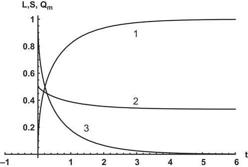
shows the graphs of and
(curves 1–3, respectively) calculated for
. As the computations show, the mini-mound slumps quite rapidly.
Fig. 4 Dimensionless abscissa of the seepage face apex , saturated area
of the shoulder and outseepage discharge
as functions of time
for an outcropping phreatic surface (curves 1–3, respectively).
Simulation of the sub-rosa mound
In the previous section, evapotranspiration was ignored and the mound discharged through the seepage face. In this section we study the relatively late post-flood stage when the plants’ transpiration becomes a more pronounced feature in the control of the mound dynamics. The effect of plant roots on the water table has been monitored and mathematically simulated for unconfined aquifers (e.g. Butler et al. Citation2007, Steward and Ahring Citation2009).
Several desert plants are intolerant of waterlogging of their roots, and can withstand fully saturated aeration-impeding soil conditions for a few days only. These plants, as mentioned in the botanical section of this paper, are generally perched-aquifer phreatophytes, i.e. their roots hover in the vadose zone above relatively small saturated lenses (whose loci are above the regional water table). Phreatophytes suck what is available from dwindling ‘saturated-soil pockets’, whose very existence is possible in a texturally-stratified vadose zone where an agrillic soil horizon and other relatively low-permeability strata intercept and detain infiltrated water from the gross drainage to the main aquifer. We surmise that our floristic band in is comprised of this hydro-ecological type of bush.
With time, roots start taking-up water from the mini-mound close to point in . Consequently, an unsaturated lacuna forms between the saturated tip
of the mini-mound and the dam toe, point
as shown in . In this section we rescale the time from the previous section as
.
Fig. 5 Vertical cross-section of the tail-water shoulder with a phreatic surface detached from the dam slope and transpiring water through a segment tapped by the plant roots (sub-rosa period of recession).
Our plants grow as a band of a fixed (for a given flood event) width and we assume that their roots, as entities withdrawing water from the phreatic surface, are correspondingly projected on it. Owing to transpiration, the mound shrinks and its tip
recedes to the left in , i.e. its abscissa, LR(t), decreases with time. The band of width b(t) of the water table segment, which is subject to transpiration, contracts; i.e.
decreases with time. The phreatic surface
drops with time but the abscissa of point
,
, remains constant. At point
the transpiring and non-transpiring segments of the phreatic surface will be stitched similarly to in the previous section; i.e. by matching the elevation at
and total flux through
.
The main assumption now is that water losses from the saturated quasi-triangle in to the root-controlled unsaturated zone are spatially uniform over the phreatic surface segment of the shrinking strip. This assumption on spatial uniformity of Strack’s (Citation1989) ‘linear phreatic sink’ is consistent with the Polubarinova-Kochina (Citation1977) 2-D potential model of phreatic surface flows with distributed accretion/losses (infiltration–evapotranspiration). The uniformity of losses (accretion) from (to) the free surface allows a systematic analytical solution of steady-state phreatic-surface problems involving evapotraspiration (e.g. Kacimov et al. Citation2004, Citation2009).
If in the transpiration losses do not vary over with
(but may vary with time) and if the vertical line
is a constant head boundary (the Dupuit-Forchheimer, DF, assumption), then
in is exactly the same as Youngs’ right-angled triangle in the previous section. The hypotenuse
of this triangle is now not a seepage face, but a water table, which yields through the vadose zone to the plant roots. Contrary to the Youngs triangle of the previous section, the angle β in is not constant, but decreases with time. Obviously, the embankment slope α in and has no influence on seepage anymore (β can be only implicitly affected by α through the roots’ depth, i.e. for steeper α plants have to send roots deeper in order to hover over
in ).
If we consider a Lagrangian point , then its motion in is purely vertical downward (in the previous section point
‘slid’ along the seepage face, ). The corresponding height
, measured from the foundation, drops with time. As already mentioned, the cathetus
in is now not moving to the right but remains stationary. The fate of water lost through the hypotenuse
in is also different from that in . In the latter case water was discharged into the atmosphere. In the former case, the roots ‘verticalize’ the horizontal Youngs’ flow. Therefore, as moisture leaves the Youngs hypotenuse, the corresponding flux becomes ascending (although across the water table
the streamlines of the conjugated saturated–unsaturated flow are smooth lines, see Kacimov Citation2006).
We shall call the saturated tongue in a sub-rosa mound because it is hydrologically clandestine to an external observer. Indeed, the mini-mound in can be identified by the seepage face. On unarmoured natural slopes (e.g. river banks), the seepage face can be easily seen by eye. Without the slope vegetation, detection of the sub-rosa mound would be possible through piezometers only. The embankment of the Al-Khod dam does not have such piezometers.
The mathematical model for the sub-rosa mound is similar to the one in the previous section. The segments and
in satisfy the equations:
The total rate of water transpired through is:
From the Youngs formula and equations (13)–(14) we immediately get:
We introduce dimensionless quantities as =
and, as usual, drop the ‘*’ superscript.
Next, we follow the Lembke transient mass balance condition . By differentiating (19) and using (16)–(17) we arrive at a nonlinear, non-autonomous first-order ODE with respect to
:
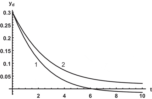
shows at
,
and
and
(curves 1 and 2, respectively). Obviously, if
from the solution of ODE (for instance, curve 1 in ), then the model has no physical sense. If transpiration vanishes with time (e.g. the plants are exterminated), then
starts increasing. This means the remaining mound spreads again rightward, ‘hunting’ for a new seepage face on the dam slope (Barenblatt’s regime, see Barenblatt et al. Citation1990). After a while the tip of this mound without transpiration arrives at point
in and we come back to the regime of the previous section. Transpiration in keeps the Youngs triangle of the ‘perched’ aquifer away from the levee slope.
Fig. 6 Length of the on-foundation cathetus of Youngs evaporating triangle (sub-rosa stage) as a function of
at
,
and
and
(curves 1 and 2, respectively).
In the geomorphology of groundwater-controlled vegetated hillslopes, the kinematics of phreatic surfaces (in particular, cyclicity) is involved on size- and time-scales much larger than in our case. Indeed, although the Boussinesq model is widely used by hillslope hydrologists (e.g. Troch et al. Citation2003), the sizes of the ‘natural flow domains’, where the model is applied, are tens, hundreds and thousands of metres. In this case, for the bulk saturated volume it does not matter whether the outlet of the phreatic surface domain is a constant-head boundary perpendicular to an impermeable base (as it should be in the DF approximation) or not (e.g. a seepage face instead of a constant head vent). In our problem the size of the flow domain is several metres, the presence or absence of the seepage face in and and accurate modelling of seepage through it and the transpiring segment of the phreatic surface are crucial. In other words, in our BVP we can not posit to be a ‘constant-head‘ outlet. As the outlet segments of the flow domain in and 5 shrink, say by two-thirds of its original size in a few days, this has a strong effect both on the mathematical solution and on the plant roots.
In our mathematical model we utilized Barenblatt’s parabola as an approximation of the genuinely 2-D moving phreatic surface and as a tool for tracking the locus of the Lagrangian slope-sliding particle in and () and the vertically dropping particle
in . Alternative proxy-shapes of BPS can be used. Instead of the Youngs triangle in we could have used a hyperbola as a steady-state evaporating phreatic surface (e.g. Kacimov et al. Citation2004). Obviously, the Youngs triangle is better because it gives an exact solution in terms of a full 2-D potential theory for any (steady or transient) flow regime (although, note the water and skeleton incompressibility is essential in Youngs’ solution). The evaporating hyperbola from Kacimov et al. (Citation2004) is a steady shape inferred from a 1-D DF approximation.
Our dam foundation is assumed to be horizontal but if in and is tilted (as in many hillslope hydrology flow schemes, e.g. Troch et al. Citation2003), then the Boussinesq equation has one more term
and the corresponding Barenblatt’s parabola can be easily stitched to a tilted right-angled triangle from Youngs (Citation1974). The Al-Khod Dam slopes are indeed planar, as depicted in and , but for other, say, natural hillslopes, instead of Youngs’ saturated triangles, we can consider quasi-steady domains with curved seepage faces as studied by Kacimov and Obnosov (Citation2002). Obviously, in the Youngs triangles of and the magnitude of the hydraulic gradient is proportional to tan α, tan β (correspondingly) and the pore pressure linearly increases from zero on the seepage face evaporating water table, to a maximum along
in . The corresponding slope stability analysis can be easily performed (e.g. Lowe Citation1967).
Does our model of seepage have advantages against other flow models? We believe, that it does. We recall that an alternative, Richards equation-based modelling requires two constitutive relationships of the unsaturated-zone soil. Although in the 1960s geotechnical engineers created and numerically tested codes for saturated–unsaturated flows (see, e.g. Freeze Citation1971), their practical application is limited by tedious measurements of the suction curve (the levee soil filling is not always easily available for regular sampling), a surrogate unsaturated conductivity function (obtained by the Burdine-Mualem integration rather than from experiments) and FDM-FEM meshing with iterative adjustments of the modelled field characteristics (hydraulic head or pore pressure). Hillslope hydrologists are actively exploiting the Richards model and corresponding commercial packages such as HYDRUS or TOUGH (e.g. Rocha et al. Citation2007), which make determination of the phreatic surface redundant. A serious and seldom discussed pitfall in the Richards model is the boundary condition at the seepage-face outlet and the necessity to track a transient front, where the type of the boundary conditions changes from no-flow (‘capillary-locked’ contour of the soil mass above the front) to isobaric (seepage face). A Laplace-equation-based numerical approach (e.g. Desai Citation1977, Rushton and Youngs Citation2010) ignores the unsaturated zone and, consequently, needs less parametric input (k and m), but is still mesh-based and essentially requires solving free or moving BVPs. This calls for a specific code and platform. Our solutions are simple: they match a Barenblatt flow element of the DF model results in analytical description of the flow with Youngs’ triangular element where a full potential theory gives an explicit solution. This conjugation of two rigorous solutions does not require a 2-D mesh, iterations or checks of convergence. It can be realized on any platform loaded with a standard computer algebra package.
In the case of our dam, unfortunately, validation of either numerical or analytical models is not possible because the levee has no piezometers or observation shafts, and soil moisture sampling from the levee shoulders and core is technically impossible.
CONCLUSIONS AND PERSPECTIVES
We observed and described a distinct band of vegetation (Nietzsche’s ‘height and light’, see the epigraph) on an infertile and coarse substrate (‘deep’) of an embankment constructed in a harsh-desert environment, the Al-Khod alluvial fan in Samail catchment near Muscat, Oman, and its response to the direct and indirect effects of extremely heavy rainfall events. The flash flood and reservoir filling, a hydrological pulse-disturbance (Hannah et al. Citation2007, Lake 2007), induces a ‘hydrological refuge’ (groundwater mini-mound) and a dependent ‘ecological refuge’ (two band-shaped phytocommunities on the two slopes of the embankment) that are sustained in the extreme drought environment. As the mini-mound microclimatic factors (wind speed, temperature, humidity and incoming radiation) on the levee slopes and in the adjacent control plain seem to be the same as in the adjacent off-lake area, we can also call the dam a ‘landscape bump’ (Adams Citation2010), which promotes two ecotones. The levee body, which is up to 11 m high, and rip-rap form a protective anti-evaporation and thermal insulation sheath to the subjacent domain of saturated soil. The mound is bounded from below and on one side by an impermeable dam base and clay core, respectively, and on the other side discharges through a seepage face at an early stage (after a reservoir-filling–emptying event), and, eventually, is consumed by a phreatic-surface distributed transpiration. If flood pulses, like Gonu and Phet, recur, then the exotic floristic composition in the area demarcated by the levee may be sustained, although it is bordered by a natural desert biome outside the lake zone.
The phytocommunity on the levee slope is controlled by the in-shoulder physical processes (infiltration, seepage, evaporation), which are controlled by the hydraulic characteristics of the levee and dam geometry. One may ask the question: is there any feedback (in the sense of Marston Citation2010) of vegetation on the dam? It is well-known (Fox and Wilson Citation2010) that slope vegetation has both positive and negative effects on slope stability. In our case of a rip-rap-loaded slope, liquefaction of the earthfill or seepage-induced caving/erosion, which the roots alleviate, are unlikely.
Although some of the observed plants have high value (Lima et al. Citation2013, Sato Citation2013) for arid zone agriculture, the pharmaceutical industry and other applications, a potential geotechnical threat is clear: if the plants obtain water in the section of the levee with the highest mini-mound elevation (OB in and ) and in the core itself (which does not transmit water horizontally but absorbs it by capillarity), then propagation of the roots to and through the core may be detrimental for the dam stability. Consequently, in May–June 2011 the Omani Ministry of Water Resources exterminated all vegetation on the slopes of our dam (see the photogallery in the Supplementary Material). However, as we observed half a year later (November 2011) some plants had re-germinated and, therefore, the levee shoulders remain a good hydrorefuge for the roots. From the lack of vegetation in zone B () on the tailwater side we deduced that water in the porous medium there is insufficient for the plant roots. Indeed, the spillway section of the dam on the tailwater side has a toe drain, which rapidly empties this segment of the shoulder, i.e. the mini-mound of does not last there long enough for the plants to be supplied from this segment of the shoulder.
Noy-Meir (Citation1973) pointed out ‘the importance of the time–space stratification of soil moisture and of the corresponding adaptive stratification of root systems’. Our results add to this that not only stratification but also the horizontal position (x-coordinate in and ) of the water table and the horizontal pattern of transpiration from it are important. In general, Noy-Meir’s ecohydrological analysis (his ) implicitly assumes hydrological interaction between his ‘reserve’ (soil water) and ‘source’ (plants) in a compartment-lumped mode (1-D vertical exchanges between the compartments). Indeed, the drainage and evaporation (even transpiration), which he described, are phenomena of vertical water transport. Further studies in ecohydrology of soil-water motion and its effect on plants incorporated PDEs (Richards model with ‘root sink’ terms) but the water dynamics was commonly conceptualized and modelled as purely vertical. As our mathematical solutions show, the mini-mound evolution is essentially 2-D. The vertical and lateral ( and ) water dynamics in the levee body is evidenced via the green and smartly- transpiring footprint of two ecotones. Similarly, Vesey-Fitzgerald (Citation1957, his Photo 1) reported a dune-toe rim of vegetation fed by lateral seepage from the post-rain ‘reserve’. Brown and Porembski (Citation1998) described a floristic system on so-called ‘micro-nebkhas’ (small-size coarse-sand mounds on a relatively low-permeable foundation of desert soil) where after rain, water redistributes within the sand volume in an essentially 3-D manner, different from the purely vertical infiltration–evaporation perceived by most vadose zone hydrologists and soil physicists. We propose to use what we have learnt from this study of a geotechnical entity (dam) in mathematical modelling of moisture motion in natural micro-nebkhas.
SUPPLEMENTARY MATERIAL
The photogallery for this article can be accessed at: http://dx.doi.org/10.1080/02626667.2014.913793
HSJ-Kacimov-BrownPhotogallery-2014.pdf
Download PDF (19.3 MB)Acknowledgements
The helpful comments of the anonymous referees are highly appreciated.
Additional information
Funding
Related Research Data
REFERENCES
- Abdalla, O. and Al-Abri, R.Y., 2011. Groundwater recharge in arid areas induced by tropical cyclones: lessons learned from Gonu 2007 in Sultanate of Oman. Environmental Earth Sciences, 63 (2), 229–239. doi:10.1007/s12665-010-0688-y.
- Adams, J.M., 2010. Vegetation–climate interaction: how vegetation makes the global environment. Chichester: Springer.
- Al-Ismaily, S., et al., 2013a. Impact of a recharge dam on the hydropedology of arid zone soils in Oman: anthropogenic formation factor. Journal of Hydrologic Engineering ASCE. doi:10.1061/(ASCE)HE.1943-5584.0000886.
- Al-Ismaily, S.S., et al., 2013b. Morphed block-crack preferential sedimentation in a reservoir bed: a smart design and evolution in nature. Hydrological Sciences Journal, 58 (8), 1779–1788. doi:10.1080/02626667.2013.838002.
- Althawadi, A.M. and Grace, J., 1986. Water use by the desert cucurbit Citrullus colocynthis (L.) Schrad. Schrad. Oecologia, 70, 475–480. doi:10.1007/BF00379514.
- Anderson, M.G. and Burt, T.P., eds., 1990. Subsurface runoff. In: Process studies in hillslope hydrology. Chichester: Wiley, 365–400. Available from: http://tocs.ulb.tu-darmstadt.de/95351574.pdf
- Aravin, V.I. and Numerov, S.N., 1953. Theory of fluid flow in undeformable porous media. Moscow: Gostekhizdat. (Engl. translation by the Israel Program Scient. Transl. Jerusalem, 1965).
- Barenblatt, G.I., Entov, V.M., and Ryzhik, V.M., 1990. Theory of fluid flows through natural rocks. Dordrecht: Kluwer.
- Barrett-Lennard, E.G., 2002. Restoration of saline land through revegetation. Agricultural Water Management, 53, 213–226. doi:10.1016/S0378-3774(01)00166-4.
- Brown Jr, G.W., 1974. Desert biology, Vol. II. New York: Academic Press.
- Brown, G., 2002. Community composition and population dynamics in response to artificial rainfall in an undisturbed desert annual community in Kuwait. Basic and Applied Ecology, 3, 145–156. doi:10.1078/1439-1791-00097.
- Brown, G., 2009. Observations on the cooling behaviour, and associated habitat, of four desert lark species (Alaudidae) in two areas of Kuwait. Sandgrouse, 31, 6–14.
- Brown, G. and Porembski, S., 1997. The maintenance of species diversity by miniature dunes in a sand-depleted Haloxylon salicornicum community in Kuwait. Journal of Arid Environments, 37, 461–473. doi:10.1006/jare.1997.0286.
- Brown, G. and Porembski, S., 1998. Flora and vegetational aspects of miniature dunes in a sand-depleted Haloxylon salicornicum community in the Kuwait desert. Flora, 193, 133–140.
- Brown, G. and Sakkir, S., 2004. Flora and vegetation of Jebel Hafit. In: S. Aspinall, and P. Hellyer, eds. Jebel Hafit, a natural history. Abu Dhabi: ENHG, 65–93.
- Butler Jr, J.J., et al., 2007. A field investigation of phreatophyte-induced fluctuations in the water table. Water Resources Research 43, W02404. doi:10.1029/2005WR004627.
- Charny, I.A., 1949. The method of successive variations of steady states and its applications to transient problems of flow of liquids and gases. Izv. AN SSSR, OTN, 323–342 (in Russian).
- Cowan, P.J. and Brown, G., 2001. Prostrate desert gourd plants as apparent cooling sites for larks in heat of day. Sandgrouse, 23, 59–60.
- Desai, C.S., 1977. Drawdown analysis of slopes by numerical method. Journal of Geotechnical Engineering ASCE, 103 (7), 667–676.
- Fell, R., MacGregor, J.P., and Stapledon, D.H., 1992. Geotechnical engineering of embankment dams. Rotterdam: Balkema.
- Fox, G.A. and Wilson, G.V., 2010. The role of subsurface flow in hillslope and stream bank erosion: a review. Soil Science Society of America Journal, 74 (3), 717–733. doi:10.2136/sssaj2009.0319.
- Freeze, R.A., 1971. Three-dimensional, transient, saturated-unsaturated flow in a groundwater basin. Water Resources Research, 7 (2), 347–366. doi:10.1029/WR007i002p00347.
- Ghazanfar, S.A., 1998. Vegetation of the plains. In: S.A. Ghazanfar, and M. Fisher, eds. Vegetation of the Arabian Peninsula. Dordrecht: Kluwer Academic Publishers, 175–190.
- Guswa, A.J., Celia, M.A., and Rodriguez-Iturbe, I., 2002. Models of soil moisture dynamics in ecohydrology: a comparative study. Water Resources Research, 38, 5–15. doi:10.1029/2001WR000826.
- Halek, V. and Svec, J., 1979. Groundwater hydraulics. New York: Elsevier.
- Hannah, D.M., Sadler, J.P., and Wood, P.J., 2007. Hydroecology and ecohydrology: challenges and future prospects. In: P.J. Wood, D.M. Hannah, J.P. Sadler, eds. Hydroecology and ecohydrology: past, present and future. Chichester: Wiley, 421–427.
- Jongbloed, M., 2003. Wildflowers of the United Arab Emirates. Abu Dhabi: Environmental Research and Wildlife Development Agency.
- Kacimov, A., et al., 2014. Cascade of proppant-sandwiched silt blocks as a double-continuum: from discovery to mathematical modeling. In: E. Pardo-Iguzquiza, et al. eds. Mathematics of planet Earth. Proceedings of the 15th annual conference of the International Association for Mathematical Geosciences. Lecture notes in Earth System Sciences. Berlin: Springer, 193–196.
- Kacimov, A.R., 1996. Explicit solutions for seepage infiltrating into a porous earth dam due to precipitation. International Journal for Numerical and Analytical Methods in Geomechanics, 20, 715–723. doi:10.1002/(SICI)1096-9853(199610)20:10<715::AID-NAG842>3.0.CO;2-0.
- Kacimov, A.R., 1997. Dynamics of ground water mounds: analytical solutions and integral characteristics. Hydrological Sciences Journal, 42 (3), 329–342. doi:10.1080/02626669709492032.
- Kacimov, A.R., 2006. Analytic element solutions for seepage towards topographic depressions. Journal of Hydrology, 318, 262–275. doi:10.1016/j.jhydrol.2005.06.019.
- Kacimov, A.R., et al., 2009. Control of sea-water intrusion by salt-water pumping: coast of Oman. Hydrogeology Journal, 17, 541–558. doi:10.1007/s10040-008-0425–8.
- Kacimov, A.R., Al-Ismaily, S., and Al-Maktoumi, A., 2010. Green-Ampt one-dimensional infiltration from a ponded surface into a heterogeneous soil. Journal of Irrigation and Drainage Engineering, 136 (1), 68–72. doi:10.1061/(ASCE)IR.1943-4774.0000121.
- Kacimov, A.R. and Obnosov, Yu.V., 2002. Analytical determination of seeping soil slopes of a constant exit gradient. ZAMM, 82 (6), 363–376. doi:10.1002/1521-4001(200206)82:6<363::AID-ZAMM363>3.0.CO;2-5.
- Kacimov, A.R., Obnosov, Yu.V., and Perret, J., 2004. Phreatic surface flow from a near-reservoir saturated tongue. Journal of Hydrology, 296, 271–281. doi:10.1016/j.jhydrol.2004.04.015.
- Kartashov, E.M., 1985. Analytical methods in theory of heat conduction through solid bodies. Moscow: Vysshaya Shkola. (in Russian).
- Lange, O.L., 1959. Untersuchungen über Wasserhaushalt und Hitzeresistenz mauretanischer Wüsten- und Savannenpflanzen. Flora, 147, 595–651.
- Le Houérou, H.N., 2005. Diffuse vs. contracted vegetation patterns: an objective demarcation between arid and desert vegetations. Israel Journal of Plant Sciences, 53, 177–182. doi:10.1560/9D9J-R77R-QJ0A-6KGQ.
- Leibenzon, L.S., 1934. Manual on mechanics of oil production. Part II. Subsurface hydraulics of water, oil and gas. Moscow: Gorgeolnefteizdat. (in Russian).
- Lembke, K.E., 1886/1887. Groundwater movement and theory of water collecting structures. J. Ministry of Transportation, N2/N17-19 (in Russian).
- Liggett, J.A. and Liu, P.L.F., 1983. The boundary integral equation method for porous media flow. London: George Allen Unwin.
- Lima, J.R.S., et al., 2013. Seasonal and interannual variations of evapotranspiration, energy exchange, yield and water use efficiency of castor grown under rainfed conditions in northeastern Brazil. Industrial Crops and Products, 50, 203–211. doi:10.1016/j.indcrop.2013.07.012.
- Loague, K., et al., 2006. Physics-based hydrologic-response simulation: foundation for hydroecology and hydrogeomorphology. Hydrological Process, 20, 1231–1237. doi:10.1002/hyp.6179.
- Lowe, J.I.I.I., 1967. Stability analysis of embankments. Journal of Soil Mechanics and Foundations, ASCE, 93 (SM4), 1–33.
- Lubczynski, M.W., 2009. The hydrogeological role of trees in water-limited environments. Hydrogeology Journal, 17, 247–259. doi:10.1007/s10040-008-0357-3.
- Ludwig, J.A., et al., 2005. Vegetation patches and runoff-erosion as interacting ecohydrological processes in semiarid landscapes. Ecology, 86, 288–297. doi:http://dx.doi.org/10.1890/03-0569.
- Marston, R.A., 2010. Geomorphology and vegetation on hillslopes: interactions, dependencies, and feedback loops. Geomorphology, 116, 206–217. doi:10.1016/j.geomorph.2009.09.028.
- Ministry of Water Resources, 1999. Dams in the Sultanate of Oman, Muscat: Ministry of Water Resources.
- Monod, T., 1954. Modes contracté et diffus de la vegetation saharienne. In: J.L. Cloudsley-Thompson, ed. Biology of deserts. London: University of London, 35–44.
- Naiman, R.J., Decamps, H., and McClain, M.E., 2005. Riparia: ecology, conservation and management of streamside communities. Amsterdam: Elsevier.
- Newman, B.D., et al., 2006. Ecohydrology of water-limited environments: a scientific vision. Water Resources Research, 42, W06302. doi:10.1029/2005WR004141.
- Noy-Meir, I., 1973. Desert ecosystems: environment and producers. Annual Review of Ecology and Systematics, 4, 25–51. doi:10.1146/annurev.es.04.110173.000325.
- Polubarinova-Kochina, P.Ya., 1977. Theory of ground-water movement. Moscow: Nauka. (in Russian).
- Porporato, A. and Rodriguez-Iturbe, I., 2002. Ecohydrology—a challenging multidisciplinary research perspective. Hydrological Sciences Journal, 47 (5), 811–821. doi:10.1080/02626660209492985.
- Ridolfi, L., et al., 2003. Stochastic soil moisture dynamics along a hillslope. Journal of Hydrology, 272, 264–275. doi:10.1016/S0022-1694(02)00270-6.
- Rocha, D., Feyen, J., and Dassargues, A., 2007. Comparative analysis between analytical approximations and numerical solutions describing recession flow in unconfined hillslope aquifers. Hydrogeology Journal, 15, 1077–1091. doi:10.1007/s10040-007-0170–4.
- Rushton, K.R. and Youngs, E.G., 2010. Drainage of recharge to symmetrically located downstream boundaries with special reference to seepage faces. Journal of Hydrology, 380, 94–103. doi:10.1016/j.jhydrol.2009.10.026.
- Sabzevari, T., et al., 2009. A steady-state saturation model to determine the subsurface travel time (STT) in complex hillslopes. Hydrology and Earth System Sciences Discussion, 6, 7179–7212. doi:10.5194/hessd-6-7179-2009.
- Sato, T., 2013. Beyond water-intensive agriculture: expansion of Prosopis juliflora and its growing economic use in Tamil Nadu, India. Land Use Policy, 35, 283–292. doi:10.1016/j.landusepol.2013.06.001.
- Sen, D., 1968. Ecology of desert plants and observations on their seedlings. II. Germination behaviour of seeds in Asclepiadaceae. Österreichische Botanische Zeitschrift, 115, 18–27. doi:10.1007/BF01373525.
- Sén, Z., 2008. Wadi hydrology. Boca Raton, FL: CRC.
- Shahin, M., 2007. Water resources and hydrometeorolgy of the Arab region. Dordrecht: Springer.
- Steward, D.R. and Ahring, T.S., 2009. An analytic solution for groundwater uptake by phreatophytes spanning spatial scales from plant to field to regional. Journal of Engineering Mathematics, 64, 85–103. doi:10.1007/s10665-008-9255-x.
- Strack, O.D.L., 1989. Groundwater mechanics. Englewood Cliffs: Prentice Hall.
- Troch, P.A., Paniconi, C., and van Loon, E.E., 2003. Hillslope-storage Boussinesq model for subsurface flow and variable source areas along complex hillslopes: 1. Formulation and characteristic response. Water Resources Research 39 (11), 1316. doi:10.1029/2002WR001728.
- Tzimopoulos, C., 1989. The artificial recharge of groundwater: a solution by successive variations of steady states. Water Resources Management, 3 (3), 231–239. doi:10.1007/BF00872344.
- Vesey-Fitzgerald, D.F., 1957. The vegetation of central and eastern Arabia. The Journal of Ecology, 45, 779–798. doi:10.2307/2256957.
- Wainwright, J., et al., 2011. Linking environmental régimes, space and time: interpretations of structural and functional connectivity. Geomorphology, 126 (3–4), 387–404. doi:10.1016/j.geomorph.2010.07.027.
- Warner, T.T., 2004. Desert meteorology. West Nyack: Cambridge Univ. Press.
- Whitford, W.G., 2002. Ecology of desert systems. San Diego, CA: Elsevier.
- Wilcox, B.P., 2010. Transformative ecosystem change and ecohydrology: ushering in a new era for watershed management. Ecohydrology, 3, 126–130. doi:10.1002/eco.104.
- Williams, D.G., et al., 2006. Sensitivity of riparian ecosystems in arid and semiarid environments to moisture pulses. Hydrological Process, 20, 3191–3205. doi:10.1002/hyp.6327.
- Wolfram, S., 1991. Mathematica. A system for doing mathematics by computer. Redwood City, CA: Addison-Wesley.
- Youngs, E.G., 1974. Seepage rates and the horizontal flow approximation. Water Resources Research 10 (4), 874–876. doi:10.1029/WR010i004p00874.
- Zalewski, M., 2000. Ecohydrology—the scientific background to use ecosystem properties as management tools toward sustainability of water resources. Guest Editorial. Ecological Engineering, 16, 1–8. doi:10.1016/S0925-8574(00)00071-9.