
Abstract
Soil erosion and eroded sediment are serious threats to sound land management. However, less attention has been given to quantifying the importance of different soil erosion features based on appropriate control measures that could be designated. Accordingly, this research was planned to quantify the contribution of potential sediment sources, i.e. sheet, rill and gully erosion, in Idelo watershed in Zanjan Province, Iran, using composite fingerprinting. Toward this aim, 16 geochemical and organic tracers were detected in sediment sources and sediment deposited at the outlet. The results of applying the composite fingerprinting technique, with a relative error of 16%, showed that sheet, rill and gully sources contributed 56%, 44% and 0%, respectively, to sediment yield. It was also apparent from the results that the composite fingerprinting approach could be successfully utilized to assess the provenance of sediment deposited at the main outlet of the study watershed by soil erosion type.
Editor Z.W. Kundzewicz
Résumé
L’érosion des sols et les sédiments érodés représentent de sérieuses menaces pour la bonne gestion des terres. Cependant, la quantification de l’importance des différentes caractéristiques de l’érosion des sols sur la base de mesures de contrôle appropriées qui pourraient être identifiées, a reçu une attention limitée. En conséquence, la présente recherche a eu pour objectif de quantifier la contribution des sources potentielles de sédiments, c’est-à-dire l’érosion en nappe, rigoles et ravines, dans le bassin versant de l’Idelo dans la province de Zanjan (Iran), à l’aide d’empreintes composites. A cette fin, 16 traceurs géochimiques et biologiques ont été détectés dans les sources de sédiments et les sédiments déposés à l’exutoire. Les résultats de l’application de la technique des empreintes composites, avec une erreur relative de 16%, ont montré que les sources de nappes, rigoles et ravines ont contribué respectivement à hauteur de 56%, 44% et 0%, au rendement sédimentaire. Les résultats ont également permis de comprendre que l’approche par empreintes composites pourrait être utilisée avec succès pour évaluer la provenance par type d’érosion des sols des sédiments déposés à l’exutoire principal du bassin versant d’étude.
INTRODUCTION
The provision of reliable information on the provenance of suspended sediment transported by rivers is important from a number of perspectives. Such information is needed: to establish watershed sediment budgets (Walling et al. Citation2008); to validate sediment yield models (Collins and Walling Citation2002); and to design plans to deal with the transport of nutrients, contaminants and damage to aquatic ecology, reservoir water storage capacity and water quality (Collins et al. Citation1997c, Juracek and Ziegler Citation2009). Perhaps more importantly, an understanding of the nature and relative importance of the principal sediment sources within a watershed is essential for the design of effective management strategies to achieve meaningful reductions in sediment loads and yields (Jenns et al. Citation2002, Collins and Walling Citation2004). Assembling detailed information on both the nature and relative importance of the primary sediment sources within a watershed represents a difficult task. Traditional direct monitoring techniques based on the use of erosion pins and troughs to estimate soil loss, a combination of pins and surveying to document channel bank contributions, or monitoring of sediment to compute the relative significance of sediment contributions from individual instrumented sub-basins to downstream suspended sediment loads, involve many operational problems and sampling constraints (Walling et al. Citation1993, Branski and Banasik Citation1996, Walling Citation2005, Collins and Walling Citation2007). Because of the problems associated with traditional methods for establishing the primary suspended sediment sources within a watershed, the fingerprinting technique, which offers an alternative approach, has been increasingly employed to identify sediment sources and avoids many of these problems. The problem is particularly complicated in developing countries like Iran where, due to financial constraints, many soil erosion control measures are not appropriately placed in the watershed area, because no prioritization has been made for sediment yield provenance.
Sediment fingerprinting is founded upon the link between the diagnostic properties of suspended sediment and those of its source material (Walling et al. Citation2006). To accomplish this, research has traditionally used single component signatures encompassing mineralogy (Klages and Hsieh Citation1975, Wood Citation1978), colour (Grimshaw and Lewin Citation1980, Carreras et al. Citation2010), mineral magnetic (Bonnet et al. Citation1989, Walden et al. Citation1997, Hatfield and Maher Citation2009, Wang et al. Citation2011), fallout radionuclides (Loughran et al. Citation1992, Walling and Woodward Citation1992, Olley et al. Citation1993, Wallbrink et al. Citation1998, Owens et al. Citation1999, Zapata Citation2003, Mabit et al. Citation2008, Citation2010, Shi et al. Citation2011, Yan et al. Citation2012, Benmansour et al. Citation2013) and organic matter (Santiago et al. Citation1992) properties. However, using single property or component signatures is likely to prove unrealistic and result in spurious linkages between source materials and sediment (Collins and Walling Citation2002), so most fingerprinting studies now employ composite fingerprints, which comprise a range of different diagnostic properties influenced by contrasting environmental controls, and thereby greatly improve the reliability of sediment source discrimination (Walling et al. Citation2006). Today composite fingerprints have been successfully employed by mixing models for source tracing and determining the relative importance of individual sediment source types in a number of different contexts (Walling and Woodward Citation1995, Russell et al. Citation2001, Motha Citation2003, Miller et al. Citation2005, Walling et al. Citation2006, Collins and Walling Citation2007, Minella et al. Citation2008, Collins et al. Citation2010a, Citation2010b).
Our review of the worldwide literature showed that previous studies mainly focused on determining the relative importance of different categories of potential sources, such as individual source types including surface soils from areas of different land use and channel banks (e.g. Walden et al. Citation1997, Russell et al. Citation2001), the spatial location of sediment sources according to tributary sub-watersheds (e.g. Collins et al. Citation1996, Walling et al. Citation1999, Shi et al. Citation2011, Benmansour et al. Citation2013) or geological zones (e.g. Walling and Woodward Citation1995, Collins et al. Citation1998, Yan et al. Citation2012). There is limited literature documenting the application of the fingerprinting approach to determine the contribution of the main erosion types, i.e. sheet, rill and gully erosion. This study to designate different soil erosion types from sediment deposited at the main outlet of the watershed using the fingerprinting technique was conducted for the Idelo watershed, one of the important sub-watersheds of the large Sefidrood basin in Iran, The aim was to: (1) determine which discriminative characteristics could differentiate the combination of different soil erosion types in the resulting sediment, and (2) to quantify the importance of different types of soil erosion in sediment from the study watershed.
MATERIAL AND METHODS
Study area
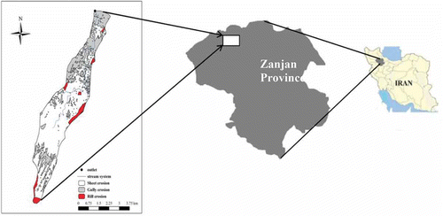
The Idelo watershed in Zanjan Province, Iran, (approx. 20 km2) is underlain by Tertiary (red gypsiferouse marl) and Quaternary (old clastic and young alluvial deposits) rocks. The annual precipitation ranges from 250 to 300 mm of which 37%, 3%, 24% and 36% falls in spring, summer, autumn and winter, respectively. Altitude ranges from 1281 m a.m.s.l. at the outlet, to 1699 m a.m.s.l. in the upstream areas, with steep slopes of 15–30%. Land use is divided between dry farming (51.2%) and rangeland (48.8%). A schematic view of the study watershed is shown in .
Fig. 1 Location of the study watershed.
Fieldwork
The fieldwork included collection of source material samples from areas of different soil erosion types and sediment sampling at the valley outlet. Sampling involved the collection of representative samples of the main potential sediment sources within the watershed. Potential sediment sources were classified according to erosion type: sheet, rill and gully erosion. A total of 50 source material samples were collected, i.e. 20 sheet erosion samples and 15 representative samples each from the rill and gully erosion areas. The samples were taken from depths of 0–2 cm (Walling and Woodward Citation1995, Walling et al. Citation1999, Collins and Walling Citation2002, Collins et al. Citation2010a, Citation2010b, Citation2010c), 2–30 cm and >30 cm (Gruszowski et al. Citation2003) for sheet, rill and gully erosion, respectively. Furthermore, six samples were collected from deposited materials at the outlet of the watershed. Care was taken to ensure that only material likely to be mobilized by each particular erosion type was collected. Accordingly, rill and gully erosion sampling sections were limited to active erosion scars (Collins et al. Citation1997b, Juracek and Ziegler Citation2009). A range of locations was ultimately sampled within the watershed to represent areas with good connectivity to the watercourse system (Walling et al. Citation2006, Collins et al. Citation2010c, Citation2010d). All samples were collected using a stainless steel trowel that was regularly cleaned to avoid inter-sample contamination (Collins and Walling Citation2002). The entire samples were then sieved to separate sediments of size of ≤63 μm to ensure that all suspended sediments from either upland or channel bed materials could be considered.
Laboratory analysis
All samples were air dried, slowly disaggregated using a pestle and mortar, and dry sieved through a 63-μm mesh to ensure sample consistency. Laboratory analysis of materials included a range of potential fingerprint properties, including three property subsets, i.e. trace metals (Fe, Mn and Al), heavy metals (As, Cd, Co, Cr, Cu, Ni, Pb, Se, V and Zn), and organic and inorganic constituents (C, N and total P). Note that these groups of fingerprint properties were selected on the basis of the availability of analytical equipment used successfully in previous studies to discriminate sediment sources (Foster and Walling Citation1994, Collins et al. Citation1997a, Collins and Walling Citation2002, Wallbrink et al. Citation2003, Walling Citation2005). The concentrations of all metals were determined using Inductively Coupled Plasma Optical Emission spectrometry, VISTA-PRO model (ICP-OES), after direct and complete digestion with H2SO4, HCLO4, HNO3 and HF acid (Marı́n et al. Citation2001, Balcerzak Citation2002, Hseu et al. Citation2002, Matusiewicz Citation2003). To assess the analytical capability of the proposed methodology, the accuracy of the total available elements was checked by including with each batch of 20 digested samples, one blank and Standard Reference Materials (SRM 2709) from the National Institute of Standards and Technology (NIST). Accordingly, the recovery rates were from 76% to 86% for the same methodology and equipment as applied for analysing the study elements in other studies. Total P was determined using UV-visible spectrophotometry after extraction with perchloric acid (Olsen and Dean Citation1965). Determination of organic C and N concentrations were undertaken using the Walkely-Black and Kjeldahl procedures (Walkely and Black Citation1934, Carter and Gregorich Citation2008).
Statistical analysis
Before using the fingerprinting approach for discriminating sediment sources, all the data were checked for univariate and multivariate outliers. The criterion of the mean ±1 SD (standard deviation) was used to identify univariate outlier data, but given the nature of geochemical data, this rule could not deliver a relevant threshold estimate for the study variables. Therefore, the median ±3 Median Absolute Deviation (MAD) criterion was used (Hampel Citation1974, Rousseeuw and Croux Citation1993):
The multivariate outliers were also addressed using the squared Mahalanobis Distance measure (D2) as a multivariate assessment of each observation across a set of variables. This method measures the distance of each observation in multidimensional space from the centroid of all observations, providing a single value for each observation, no matter how many variables are considered. For detection of outliers, the D2 measure was divided by the degrees of freedom (df) equal to the number of variables involved (D2/df); its distribution approximates a t-value. Given the nature of the statistical tests, it was suggested that a conservative level of significance (0.001) be used as the threshold value for detection as an outlier. So, observations having a value of D2/df > 2.5 in samples of under 80 observations were designated as possible outliers (Tabachick and Fidell Citation2007, Hair Citation2010).
In addition, a sufficient number of samples per category was taken for use of multivariate Discriminant Function Analysis (DFA) so that the minimum ratio of sample size to the number of tracers was approximately five, and at least 15 to 20 observations per category were considered (Hair Citation2010). The two-stage statistical procedure proposed by Collins et al. (Citation1997a) was employed to confirm the discrimination of the potential sediment sources in the watershed. In stage one, all fingerprint properties were tested for their ability to discriminate source types encompassing sheet, rill and gully erosion using the Kruskal-Wallis H-test and One-Way ANOVA. The One-Way ANOVA and Kruskal-Wallis H-test were used for normally and non-normally distributed data, respectively (Tabachick and Fidell Citation2007).
In the next step, DFA was employed to identify composite fingerprints likely to distinguish source types involving sheet, rill and gully erosion. Application of DFA was based on three assumptions, namely normality of independent variables, lack of collinearity among independent variables and equality of group covariance matrices that needed to be satisfied initially (Hair Citation2010). For the first assumption, we assessed the univariate and multivariate normality. The Kolmogrov-Smirnov test and normal probability plots were used for normality testing, recognizing that achieving univariate normality of individual variables will often suffice to reach multivariate normality as well, as DFA is robust to failures of normality if non normality (violation of the assumption) is caused by skewness in outlier data (Tabachick and Fidell Citation2007). For the collinearity, we used two criteria, i.e. correlation matrix and tolerance (TOL) or Variance Inflation Factor (VIF). The correlation matrix was used as the simplest means of distinguishing collinearity for the independent variables. Generally, a level of 0.9 and higher of correlation shows the first criterion of significant collinearity. But it does not ensure a lack of collinearity because multi-collinearity may occur due to the combined effect of two or more other independent variables. To overcome this issue, we used TOL and VIF (Tabachick and Fidell Citation2007, Hair Citation2010). Tolerance indicates that two or more independent variables are explained by the other variables and thus will not have high explanatory power in fingerprinting (Hair Citation2010). In other words, tolerance denotes the proportion of the variation in the independent variables not explained by the variables already in the function. A tolerance with 0 value means the independent variable under discussion is a complete linear combination of independent variables already in the function. Generally acceptable levels of TOL and VIF (VIF is the inverse of TOL) are up to 0.1 and below 10, respectively; violation of these thresholds indicates multicollinearity among variables (Hair Citation2010).
Finally, the equality of group covariance matrices was assessed with Box’s M test. In this approach an attempt is made to find a nonsignificant probability level which indicates that there are no differences between the group covariance matrices. When the assumption is challenged, using group-specific covariance matrices instead of total covariance matrices can minimize this effect and a significant level is not regarded as too important (Hair Citation2010). Composite fingerprints were finally constructed using the criterion D2 in the stepwise method (Hair Citation2010). According to this method, D2 is used to select the variable that has a statistically significant difference across groups while maximizing D2 between the other closest groups. In this manner, statistically significant variables are selected that maximize the discrimination between the most similar groups at each stage. This procedure continues as long as additional variables provide statistically significant discrimination beyond those differences already accounted for by the variables in the discriminant function.
Source quantification
Finally, the fingerprint of the sediment deposited at the outlet was compared with that of the potential sources. This was achieved using a multivariate mixing model (Walling and Woodward Citation1995, Miller et al. Citation2005, Walling et al. Citation2006, Collins and Walling Citation2007, Minella et al. Citation2008, Collins et al. Citation2010a, Citation2010b):
where Ci is the concentration of element i in the sediment sample; aij is the mean concentration of fingerprint property i in source j; Pj is the optimized percentage contribution from source s; m is the number of fingerprint properties comprising the optimum composite fingerprint and n is the number of sediment source type categories. The model seeks to satisfy the following constraints:
Since the model is over determined, it must be fitted iteratively by minimizing an objective function. Accordingly, the objective function was optimized by minimizing the sum of the squares of the deviations (R) of the predicted property concentrations from the measured values, to determine the relative contribution of each potential source. In many studies, two correction factors, the tracer-specific weighting and particle-size correction factors, have been used, but here, because of equipment constraints, the only form of correction possible was the sieving of both source and sediment samples through a 63-μm mesh. Equation (5) shows the objective function that was executed using the Solver function in Microsoft Excel (Walling et al. Citation2006):
To provide an indication of the uncertainty associated with the mixing model, goodness-of-fit tests were also applied, due to their ease of application at the time of conducting the research, in which the fingerprint property concentrations measured in the sediment samples were compared with the corresponding values predicted by the model. It is now conventional for the modelling component of source fingerprinting studies to assess the stability of the average solutions by applying the Monte Carlo routine and genetic algorithms (Collins and Walling Citation2007, Collins et al. Citation2010b, Citation2010d).
RESULTS AND DISCUSSION
Based on the methodology explained above, 16 fingerprinting elements were measured in source areas (i.e. different erosion types) and sediment deposited at the main outlet of the watershed (). As seen in , the coefficient of variation (CV) ranges from 16.90% to 100.56% for Co and P, respectively. Many of the properties have positive skewness, which is due to mineralization or rare geochemical processes and contaminating human activities, as reported by Lalor and Zhang (Citation2001) and Reimann et al. (Citation2005). As there was no contaminating human activity in the study region, the skewed distribution can be attributed to the nature of geochemical data.
Table 1 Descriptive statistics of 16 fingerprinting elements in source material and sediment samples of the study watershed. All elements except OC (organic carbon, %) and N (%) are in μg g-1. SD: standard deviation; CV: coefficient of variation.
Applying the univariate outlier criterion showed that all data were within the threshold ranges. The results of applying the D2/df criterion are given in . Only sample 46 was designated as an outlier, having a D2/df value of 3.11 exceeding the critical value of 2.5 (Hair et al. Citation2010).
Table 2 Results of applying the multivariate outlier criterion of ration of squared Mahalanobis Distance measure (D2) to degrees of freedom (df) for outlier designation.
The results of applying appropriate ANOVA and Kruskal-Wallis tests are given in , which shows that, out of the 16 study elements, just Fe, Zn, Se and Ni, with p values below 5%, were capable of discriminating erosion types as a source of sediment. This result basically agrees with those of Collins et al. (Citation1997a, Citation1997b), Owens et al. (Citation1999), Collins and Walling (Citation2002), Walling (Citation2005), and Collins and Walling (Citation2007).
Table 3 Results of One-Way ANOVA and Kruskal-Wallis H-test application to the source type fingerprint properties datasets.
presents the final results of the DFA for the study watershed. The optimum composite fingerprints selected by DFA, Fe, Zn and Cr, could correctly distinguish only 64% of the source type samples, a result which agrees with that reported by Owens et al. (Citation1999). This may highlight the importance of fallout radionuclides such as caesium-137 (Cs137), excess lead-210 (Pb210) and beryllium-7 (Be7) for application of other elements or increasing the level of distinction of the erosion type (Bonnet et al. Citation1989, Walling and Woodward Citation1992, Walling Citation2005). According to and , unlike the findings of previous studies (e.g. Collins et al. Citation1997c, Collins and Walling Citation2002), the organic matter and total P properties could not discriminate between the source materials. This may reflect the low percentage of vegetation cover due to which no significant differences could be found in concentrations of C, N and total P as a function of soil profile depth expected to correspond to different erosion processes.
Table 4 Final results of the stepwise Discriminant Function Analysis (DFA) for the Idelo watershed, Iran.
The contribution from each sediment source is represented in . Clearly the highest mean contribution is provided by sheet erosion (56%), whereas no contribution has been recorded for gully erosion (0%).
Fig. 2 Mean mixing model estimates for the relative sediment contributions from each source type to the suspended sediment sampled at the outlet of the study watershed.
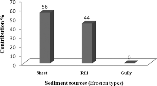
To provide an indication of the uncertainty associated with the mixing model, goodness-of-fit tests comparing the fingerprint property concentrations measured in the sediment samples with the corresponding values predicted by the model, based on the optimized contributions from the individual source types to those samples, indicated a typical relative error of ±16%. This level of uncertainty confirms that the optimized mixing model provides an acceptable prediction of the fingerprint property concentrations associated with sediment samples and lies within ranges reported by Walling et al. (Citation2006), Minella et al. (Citation2008) and Collins et al. (Citation2010c). High inputs from sheet erosion are consistent with susceptible soil; fine grained particles, poor vegetation and a large area promote relatively high sediment yields. This is supported by Walling and Webb (Citation1996), Walden et al. (Citation1997), Walling et al. (Citation1999), Russell et al. (Citation2001) and Walling et al. (Citation2006). Although rill erosion covers only 5.07% of the watershed area, its contribution to sediment yield (44%) is relatively high. Enhanced sediment generation by rills is associated with the extension of rill erosion in steep areas; furthermore, they are well connected to the drainage system because of soluble materials in soils facilitating extensive piping phenomena.
The spatial distribution of different soil erosion types also affects their contribution to the sediment yield at the outlet, as emphasized by Sadeghi and Mahdavi (Citation2004) for a watershed in Iran. Based on the field evidence and visual evaluations, it seems that the watershed is relatively stable regarding soil erosion, and just initial forms of soil erosion contribute to sediment yield. There is no contribution from gully erosion, which reflects the successful performance of different check dams (e.g. gabion and wire meshed), which effectively obstruct the transport of eroded material. The large proportion of coarse materials at depths >30 cm and the need for high flows to be able to transport such material, may be further reasons for the negligible contribution of gully erosion to sediment reaching the main outlet of the watershed.
CONCLUSION
This study aimed to test of the extent to which the composite fingerprinting approach can be successfully utilized to assess the source type provenance of sediment transported through the Idelo watershed. Several geochemical and organic tracers were recognized in source sediment and sediment transported to the main outlet. Field sampling was conducted and laboratory analyses carried out to quantitatively determine the selected tracers. Statistical procedures and assessments were adopted to quantify the relative contribution of each potential source in sediment delivered to the watershed outlet. The results show that surface soils eroded by sheet and rill erosion are the only sediment source in the watershed. The results also show the necessity for use of further fingerprinting elements, such as radionuclide tracers to improve the analyses. Extended research and field measurement are required to improve the understanding of erosion and deposition, and lead to the design of holistic policies for soil erosion and sediment control.
REFERENCES
- Balcerzak, M., 2002. Sample digestion methods for the determination of traces of precious metals by spectrometric techniques. Analytical Sciences, 18, 737–750. doi:10.2116/analsci.18.737
- Benmansour, M., et al., 2013. Assessment of soil erosion and deposition rates in a Moroccan agricultural field using fallout 137Cs and 210Pbex. Journal of Environmental Radioactivity, 115, 97–106. doi:10.1016/j.jenvrad.2012.07.013
- Bonnet, P.J.P., Leeks, G.J.L., and Cambray, R.S., 1989. Transport processes for Chernobyl-labelled sediments: preliminary evidence from upland mid-Wales. Land Degradation and Development, 1, 39–50. doi:10.1002/ldr.3400010105
- Branski, J. and Banasik, K., 1996. Sediment yields and denudation rates in Poland. In: D.E. Walling and B.W. Webb, eds. Erosion and sediment yield. Global and regional perspectives, 236. Wallingford: International Association of Hydrological Science Publication, 133–138.
- Carreras, N.M., et al., 2010. The use of sediment colour measured by diffuse reflectance spectrometry to determine sediment sources: application to the Attert River catchment (Luxembourg). Journal of Hydrology, 382, 49–63. doi:10.1016/j.jhydrol.2009.12.017
- Carter, M.R. and Gregorich, E.G., 2008. Soil sampling and methods of analysis. 2nd ed. Boca Raton, FL: CRC Press, 1224.
- Collins, A.L. and Walling, D.E., 2002. Selecting fingerprint properties for discriminating potential suspended sediment source in river basins. Journal of Hydrology, 261, 218–244. doi:10.1016/S0022-1694(02)00011-2
- Collins, A.L. and Walling, D.E., 2004. Documenting catchment suspended sediment sources: problems, approaches and prospects. Progress in Physical Geography, 28, 159–196. doi:10.1191/0309133304pp409ra
- Collins, A.L. and Walling, D.E., 2007. Sources of fine sediment recovered from the channel bed of lowland groundwater-fed catchments in the UK. Geomorphology, 88, 120–138. doi:10.1016/j.geomorph.2006.10.018
- Collins, A.L., Walling, D.E., and Leeks, G.J.L., 1996. Composite fingerprinting of the spatial source of fluvial suspended sediment: a case study of the Exe and Severn river basins, United Kingdom. Géomorphologie: Relief, Processus, Environnement, 2, 41–53. doi:10.3406/morfo.1996.877
- Collins, A.L., Walling, D.E., and Leeks, G.J.L., 1997a. Source type ascription for fluvial suspended sediment based on a quantitative composite fingerprinting technique. Catena, 29, 1–27. doi:10.1016/S0341-8162(96)00064-1
- Collins, A.L., Walling, D.E., and Leeks, G.J.L., 1997b. Fingerprinting the origin of fluvial suspended sediment in larger river basins: combining assessment of spatial provenance and source type. Geografiska Annaler, Series A: Physical Geography, 79 (4), 239–254. doi:10.1111/j.0435-3676.1997.00020.x
- Collins, A.L., Walling, D.E., and Leeks, G.J.L., 1997c. Sediment sources in the Upper Severn catchment: a fingerprinting approach. Hydrology and Earth System Sciences, 1 (3), 509–521. doi:10.5194/hess-1-509-1997
- Collins, A.L., Walling, D.E., and Leeks, G.J.L., 1998. Use of composite fingerprints to determine the provenance of the contemporary suspended sediment load transported by rivers. Earth Surface Processes and Landforms, 23, 31–52. doi:10.1002/(SICI)1096-9837(199801)23:1<31::AID-ESP816>3.0.CO;2-Z
- Collins, A.L., et al., 2010a. A preliminary investigation of the efficacy of riparian fencing schemes for reducing contributions from eroding channel banks to the siltation of salmonid spawning gravels across the south west UK. Journal of Environmental Management, 91, 1341–1349. doi:10.1016/j.jenvman.2010.02.015
- Collins, A.L., et al., 2010b. Tracing sediment loss from eroding farm tracks using a geochemical fingerprinting procedure combining local and genetic algorithm optimisation. Science of the Total Environment, 408, 5461–5471. doi:10.1016/j.scitotenv.2010.07.066
- Collins, A.L., et al., 2010c. Assessing damaged road verges as a suspended sediment source in the Hampshire Avon catchment, southern United Kingdom. Hydrological Processes, 24, 1106–1122. doi:10.1002/hyp.7573
- Collins, A.L., et al., 2010d. Apportioning catchment scale sediment sources using a modified composite fingerprinting technique incorporating property weightings and prior information. Geoderma, 155, 249–261. doi:10.16/j.geoderma.2009.12.008
- Foster, I.D.L. and Walling, D.E., 1994. Using reservoir deposits to reconstruct changing sediment yields and sources in the catchment of the Old Mill Reservoir, South Devon, UK, over the past 50 years. Hydrological Sciences Journal, 39, 347–368. doi:10.1080/02626669409492755
- Grimshaw, D.L. and Lewin, J., 1980. Source identification for suspended sediments. Journal of Hydrology, 47, 151–162. doi:10.1016/0022-1694(80)90053-0
- Gruszowski, K.E., et al., 2003. Sediment sources and transport pathways in a rural catchment, Herefordshire, UK. Hydrological Processes, 17, 2665–2681. doi:10.1002/hyp.1296
- Hair, J.F., et al., 2010. Multivariate data analysis. 7th ed. Upper Saddle River, NJ: Pearson Prentice Hall.
- Hampel, F.R., 1974. The influence curve and its role in robust estimation. Journal of the American Statistical Association, 69, 383–393. doi:10.1080/01621459.1974.10482962
- Hatfield, R.G. and Maher, B.A., 2009. Fingerprinting upland sediment sources: particle size-specific magnetic linkages between soils, lake sediments and suspended sediments. Earth Surface Processes and Landforms, 34, 1359–1373. doi:10.1002/esp.1824
- Hseu, Z.Y., et al., 2002. Digestion methods for total heavy metals in sediment and soils. Water, Air and Soil Pollution, 141, 189–205. doi:10.1023/A:1021302405128
- Jenns, N., et al., 2002. Investigating contemporary and historical sediment inputs to Slapton Higher Ley: an analysis of the robustness of source ascription methods when applied to lake sediment data. Hydrological Processes, 16, 3467–3486. doi:10.1002/hyp.1110
- Juracek, K.E. and Ziegler, A.C., 2009. Estimation of sediment sources using selected chemical tracers in the Perry lake basin, Kansas, USA. International Journal of Sediment Research, 24, 108–125. doi:10.1016/S1001-6279(09)60020-2
- Klages, M.G. and Hsieh, Y.P., 1975. Suspended solids carried by the Gallatin River of southwestern Montana: II. Using mineralogy for inferring sources. Journal of Environment Quality, 4, 68–73. doi:10.2134/jeq1975.00472425000400010016x
- Lalor, G.C. and Zhang, C., 2001. Multivariate outlier detection and remediation in geochemical databases. The Science of the Total Environment, 281, 99–109. doi:10.1016/S0048-9697(01)00839-7
- Loughran, R.J., et al., 1992. Developing a sediment budget for a small drainage basin in Australia. Hydrological Processes, 6, 145–158. doi:10.1002/hyp.3360060203
- Mabit, L., et al., 2010. Establishment of control site baseline data for erosion studies using radionuclides: a case study in East Slovenia. Journal of Environmental Radioactivity, 101 (10), 854–863. doi:10.1016/j.jenvrad.2010.05.008
- Mabit, L., Benmansour, M., and Walling, D.E., 2008. Comparative advantages and limitations of the fallout radionuclides 137Cs, 210Pbex and 7Be for assessing soil erosion and sedimentation. Journal of Environmental Radioactivity, 99 (12), 1799–1807. doi:10.1016/j.jenvrad.2008.08.009
- Marı́n, A., López-Gonzálvez, A., and Barbas, C., 2001. Development and validation of extraction methods for determination of zinc and arsenic speciation in soils using focused ultrasound application to heavy metal study in mud and soils. Analytica Chimica Acta, 442, 305–318. doi:10.1016/S0003-2670(01)01169-2
- Matusiewicz, H. 2003. New horizons and challenges in environmental analysis and monitoring, Plenary lectures and major contributions to the workshop, Gdansk. 18–29 August 2003.
- Miller, R.J., et al., 2005. Historical trends in sedimentation rates and sediment provenance, Fairfield Lake, Western North Carolina. Journal of the American Water Resources Association, 41, 1053–1075. doi:10.1111/j.1752-1688.2005.tb03785.x
- Minella, J.P.G., Walling, D.E., and Merten, G.H., 2008. Combining sediment source tracing techniques with traditional monitoring to assess the impact of improved land management on catchment sediment yields. Journal of Hydrology, 348, 546–563. doi:10.1016/j.jhydrol.2007.10.026
- Motha, J.A., et al., 2003. Determining the sources of suspended sediment in a forested watershed in southeastern Australia. Water Researches Research, 39 (3), 1056–1069.
- Olley, J.M., et al., 1993. Identifying sediment sources in a gullied catchment using natural and anthropogenic radioactivity. Water Resources Research, 29, 1037–1043. doi:10.1029/92WR02710
- Olsen, S.R. and Dean, L.A., 1965. Phosphorous. In: C.A. Black, ed. Methods of soil chemical analysis. Part 2. Madison, WI: American Society of Agronomy, 1035–1049.
- Owens, P.N., Walling, D.E., and Leeks, G.J.L., 1999. Use of floodplain sediment cores to investigate recent historical changes in overbank sedimentation rates and sediment sources in the catchment of the River Ouse, Yorkshire, UK. Catena, 36, 21–47. doi:10.1016/S0341-8162(99)00010-7
- Reimann, C., Filzmoser, P., and Garrett, R.G., 2005. Background and threshold: critical comparison of methods of determination. Science of the Total Environment, 346, 1–16. doi:10.1016/j.scitotenv.2004.11.023
- Rousseeuw, P.J. and Croux, C., 1993. Alternatives to the median absolute deviation. Journal of the American Statistical Association, 88, 1273–1283. doi:10.1080/01621459.1993.10476408
- Russell, M.A., Walling, D.E., and Hodgkinson, R.A., 2001. Suspended sediment sources in two small lowland agricultural catchments in the UK. Journal of Hydrology, 252, 1–24. doi:10.1016/S0022-1694(01)00388-2
- Sadeghi, S.H.R. and Mahdavi, M., 2004. Applicability of SEDMAT II model in flood and sediment yield estimation. Journal of Agricultural Science Technology (JAST), 7, 69–77.
- Santiago, S., et al., 1992. Particle size characteristics of suspended and bed sediments in the rhône river. Hydrological Processes, 6, 227–240. doi:10.1002/hyp.3360060210
- Shi, Z., et al., 2011. Comparison of the soil losses from 7Be measurements and the monitoring data by erosion pins and runoff plots in the Three Gorges Reservoir region, China. Applied Radiation and Isotopes, 69 (10), 1343–1348. doi:10.1016/j.apradiso.2011.05.031
- Tabachnick, B.G. and Fidell, L.S., 2007. Using multivariate statistics. 5th ed. Boston, MA: Pearson Education, Inc, 1008.
- Walden, J., Slattery, M.C., and Burt, T.P., 1997. Use of mineral magnetic measurements to fingerprint suspended sediment sources: approaches and techniques for data analysis. Journal of Hydrology, 202, 353–372. doi:10.1016/S0022-1694(97)00078-4
- Walkley, A. and Black, I.A., 1934. An examination of the Degtjareff method for determining soil organic matter, and a proposed modification of the chromic acid titration method. Soil Science, 37, 29–38. doi:10.1097/00010694-193401000-00003
- Wallbrink, P.J., et al., 1998. Determining sources and transit times of suspended sediment in the Murrumbidgee River, New South Wales, Australia, using fallout137Cs and210Pb. Water Resources Research, 34, 879–887. doi:10.1029/97WR03471
- Wallbrink, P.J., Martin, C.E., and Wilson, C.J., 2003. Quantifying the contributions of sediment, sediment-P and fertiliser-P from forested, cultivated and pasture areas at the landuse and catchment scale using fallout radionuclides and geochemistry. Soil and Tillage Research, 69, 53–68. doi:10.1016/S0167-1987(02)00128-9
- Walling, D.E., 2005. Tracing suspended sediment sources in catchments and river systems. Science of the Total Environment, 344, 159–184. doi:10.1016/j.scitotenv.2005.02.011
- Walling, D.E., et al., 2006. Establishing fine-grained sediment budgets for the Pang and Lambourn LOCAR catchments, UK. Journal of Hydrology, 330, 126–141. doi:10.1016/j.jhydrol.2006.04.015
- Walling, D.E., Collins, A.L., and Stroud, R.W., 2008. Tracing suspended sediment and particulate phosphorus sources in catchments. Journal of Hydrology, 350, 274–289. doi:10.1016/j.jhydrol.2007.10.047
- Walling, D.E., Owens, P.N., and Leeks, G.J.L., 1999. Fingerprinting suspended sediment sources in the catchment of the River Ouse, Yorkshire, UK. Hydrological Processes, 13, 955–975. doi:10.1002/(SICI)1099-1085(199905)13:7<955::AID-HYP784>3.0.CO;2-G
- Walling, D.E. and Webb, B.W. 1996. Erosion and sediment yield: a global overview. In: D.E. Walling and B.W. Webb, eds. Erosion and sediment yield: global and regional perspectives. Wallingford: IAHS Publ. 236, 29–33.
- Walling, D.E. and Woodward, J.C., 1992. Use of the radiometric fingerprints to derive information on suspended sediment sources. In: J. Bogen, D.E. Walling and T.J. Day, eds. Erosion and sediment transport monitoring programmes in river basins. Wallingford: IAHS Publ. 210, 153–164.
- Walling, D.E. and Woodward, J.C., 1995. Tracing sources of suspended sediment in River Basins: a case study of the River Clum, Devon, UK. Marine and Freshwater Research, 46, 327–336.
- Walling, D.E., Woodward, J.C., and Nicholas, A.P., 1993. A multi-parameter approach to fingerprinting suspended sediment sources. In: N.E. Peters, et al., eds. Hydrology of warm humid regions. Wallingford: IAHS Publ. 215, 329–338.
- Wang, H., et al., 2011. Comparing mineral magnetic properties of sediments in two reservoirs in “strongly” and “mildly” eroded regions on the Guizhou Plateau, southwest China: a tool for inferring differences in sediment sources and soil erosion. Geomorphology, 130, 255–271. doi:10.1016/j.geomorph.2011.04.003
- Wood, P.A., 1978. Fine-sediment mineralogy of source rocks and suspended sediment, rother catchment, West Sussex. Earth Surface Processes, 3, 255–263. doi:10.1002/esp.3290030305
- Yan, D., et al., 2012. Assessment of sediment yield in a small karst catchment by using 137Cs tracer technique. International Journal of Sediment Research, 27 (4), 547–554. doi:10.1016/S1001-6279(13)60012-8
- Zapata, F., 2003. The use of environmental radionuclides as tracers in soil erosion and sedimentation investigations: recent advances and future developments. Soil and Tillage Research, 69 (1–2), 3–13. doi:10.1016/S0167-1987(02)00124-1