
Abstract
River science and management often require a design or reference discharge. The common (and sometimes unavoidable) use of such discharges may, however, obscure the fact that the magnitude and frequency of critical flows can differ due to various hydrological, geomorphological, and ecological criteria. Threshold stages and discharges were identified for six lower Brazos River, Texas gaging stations corresponding to thalweg connectivity, bed inundation, high sub-banktop flows, channel–floodplain connectivity (CFC), and overbank flooding. Critical flows were also identified for estimated thresholds for sandy bedform and medium gravel mobility, critical specific stream power for potential channel modifications, and cohesive-bank channel erosion. These thresholds have variable relationships to mean, median, and maximum flows. For four of the six stations, daily recurrence probabilities for all but flood flows are at least 1%, and as high as 11%. All stations achieve channel–floodplain connectivity at stages less than banktop. Estimated threshold flows for sediment mobility and channel erosion occur relatively frequently, with daily probabilities of 2–77%. Critical flows for bank erosion occur least often, and for sandy bedform and gravel mobility most often. Thalweg connectivity is always maintained at all sites, while bed inundation flows have a daily probability of about 80% or more. Overall, results suggest that no single flow level is dominant in hydrological or geomorphic dynamics, and that the frequency of a given threshold varies considerably even along a single river. The results support the idea that multiple flow levels and ranges are necessary to create and maintain the hydrological, geomorphological, and ecological characteristics of rivers, and that no single flow level is a reliable determinant of fluvial state.
Editor Z.W. Kundzewicz; Associate editor Q. Zhang
Résumé
L’étude et la gestion d’une rivière font souvent appel à un débit de référence ou de projet. L’usage habituel (et parfois inévitable) de ces débits peut cependant occulter le fait que l’intensité et la fréquence des débits critiques peuvent différer en raison de divers critères hydrologiques, géomorphologiques et écologiques. Des seuils de niveaux et de débits ont été déterminés en six stations de jaugeage situées à l’aval de la rivière Brazos (Texas) pour la connectivité de thalweg, le lit mineur, l’écoulement de plein bord, la connectivité du lit majeur et son inondation. Des débits critiques ont également été déterminés pour l’estimation de seuils concernant la mobilité des lits sableux et graveleux, la puissance spécifique du débit susceptible de modifier le chenal d’écoulement, et l’érosion des berges cohérentes du chenal. Ces seuils ont des relations variables à la moyenne, à la médiane et au maximum du débit. Pour quatre des six stations, les probabilités de récurrence quotidienne pour tous ces seuils, à l’exception des débits de crue sont d’au moins 1%, et peuvent atteindre 11%. Pour toutes les stations la connectivité du chenal et de la plaine d’inondation est atteinte pour des niveaux inférieurs au niveau de plein bord. Les seuils de débit estimés pour la mobilité des sédiments et l’érosion du chenal sont assez fréquemment atteints, avec des probabilités quotidiennes de 2 à 77%. Les débits critiques pour l’érosion des berges se produisent moins souvent, les lits sableux et graveleux étant les plus affectés. La connectivité du thalweg est toujours conservée sur tous les sites, alors que les débits du lit mineur ont une probabilité quotidienne d’au moins 80%. Ces résultats suggèrent en définitive que de multiples niveaux et gammes de débits contribuent à créer et à maintenir les caractéristiques hydrologiques, géomorphologiques et écologiques d’un cours d’eau, et qu’aucun indicateur unique de débit ne peut caractériser de façon fiable son état.
INTRODUCTION
Stream assessment, management, restoration, and rehabilitation often require specification of a design or reference discharge. These are most commonly defined on the basis of bankfull flow, a particular recurrence interval (typically 1 to 2 years), or effective discharge (the flow responsible for the greatest total geomorphic work or sediment transport). The widespread (and sometimes unavoidable) use of these normative discharges may, however, obscure the fact that the important or critical flows may differ substantially in magnitude and frequency based on different hydrological, geomorphological, and ecological criteria.
Even for a small set of geomorphic criteria the magnitude and frequency of discharges may be quite variable (e.g. Phillips Citation2002, Lenzi et al. Citation2006, Heitmuller Citation2011). For example, the geomorphic notion of a ‘formative discharge’, primarily responsible for channel morphology, was investigated by Surian et al. (Citation2009) in the Tagliamento River, Italy. They found different formative discharges with recurrence intervals ranging from several times per year to 12 years for channel banks, bars, and islands. With respect to effective discharge for several ecological parameters, Doyle et al. (Citation2005) found that the effective flow relative to the modal flow varied by four orders of magnitude.
While engineering, restoration, and benchmarking may require some design or reference flow, management of environmental flows (see below) increasingly calls for maintaining a range of flows. The Downstream Response to Imposed Flow Transformation (DRIFT) method developed in South Africa, for instance, is scenario-based and encompasses a full range of flows relevant to major biotic and abiotic factors (King et al. Citation2003). The Texas environmental flows program, which provides the context for this study, is also based on multiple flow levels.
Environmental or instream flow programs are generally intended to ensure that water withdrawals or diversions or flow interruptions are managed so as to minimize adverse impacts on downstream uses and ecosystem services. Such programs are strongly influenced by politics and scientific uncertainty, described in Texas case studies by Roach (Citation2013).
This study identifies potential thresholds in the lower Brazos River, Texas, with respect to geomorphic changes and hydrologically critical stages. In this way the hydrological and geomorphic responses (and associated ecological impacts and engineering and management ramifications) of instream flow changes can be assessed. Instream flows may be modified by natural climate and hydrological change, by land use change, and by direct human actions such as impoundments and water withdrawals, diversions, and transfers.
This project was driven not only by concern with potential impacts of climate and land-use change, but also by the needs of instream or environmental flows programs. Instream flow programs (IFP) are intended to balance human and non-human uses of water. The Texas IFP was established by legislation mandating a state water planning process to consider environmental values in water development and allocation. State agencies were directed to conduct an instream flow data collection and evaluation program, and to determine flow conditions in Texas streams necessary to support, in the words of the enabling legislation, “a sound ecological environment”. The IFP work plan and technical overview are available from http://www.twdb.state.tx.us/instreamflows/.
By about 2010 there already existed more than 200 methods for estimating environmental or ecological flow needs, based on a variety of hydrological, hydraulic, ecological, engineering, and geomorphic criteria (Liu et al. Citation2011, p. 17). A review of instream or environmental flow issues is beyond the scope of this paper; refer to Meitzen et al. (Citation2013) for a recent discussion of the relationships among hydrological, geomorphological, and ecological considerations in environmental flow problems.
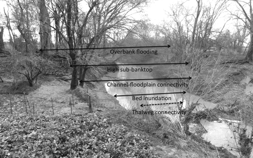
Previous work on instream flows in Texas cites five key discharge levels or stages (). Thalweg connectivity is the minimum flow necessary to connect pools within the channel to maintain some downstream water flow, and provide some opportunity for movement of aquatic biota. The next highest critical stage is bed inundation, the water level necessary to submerge all bedforms, aquatic habitats, and channel bottom area between the lower banks on both sides of the channel. Because unconsolidated fines are mobile with minimal flow velocities, this is also approximately the minimum flow necessary to prevent buildup of mud deposits on benthic habitats. The third key stage is called high sub-banktop, and is defined as high flows contained entirely within the channel banks, as defined by the morphological bank tops. This actually refers to a range of stages below that for overbank flow, and above mean or median flows. Fourth is the flow necessary to create channel–floodplain connectivity, which for practical purposes can be defined as a flux or exchange of flow between the river channel and floodplain depressions (sloughs, oxbows, lakes, etc.). This may occur due to occupation of high flow sub-channels, or flow through gaps in the natural levee. It may also occur because of backwater flooding of tributaries, as the latter may be connected to floodplain depressions, and their bank top and levee elevations are sometimes less than that of the Brazos River in the vicinity of the confluences. Thus, the channel–floodplain connectivity stage may be less than that for high sub-banktop flow or overbank flooding. The latter is the stage associated with general overtopping of levees and floodplain inundation.
Fig. 1 Key flow stages illustrated using the channel of Hardin Slough, a Brazos River tributary. The thalweg connectivity stage would be less than the water level shown in the photo, which at the time was slightly above bed inundation stage.
This study also investigated specific discharge thresholds for geomorphic change. Thresholds for movement or transport of various particle sizes or for erosion of various channel materials may be expressed in terms of shear stress, stream power, or critical velocities relative to particle size or resistance. Shear stress varies with depth and slope, and is most applicable to estimating thresholds of motion for individual particles or initiation of erosion of specific materials. Stream power varies with discharge and slope, and is best suited for estimates of the total erosive or transport capacity. Velocity is a function of slope, depth, and hydraulic roughness and is related to (among other things) transitions in the state of sand bed channels with respect to bedforms. The three are related, but not perfectly so. For example, a riffle will have higher velocity and lower depth than an adjacent pool with the same discharge, and the relative water surface slopes may vary with flow conditions.
STUDY AREA
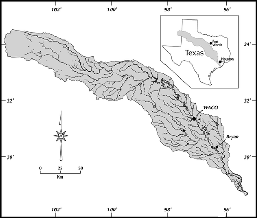
The study area is the Brazos River from the south side of Waco to the river mouth, a distance of 681 km. The Brazos River has a drainage area of about 118 000 km2, and a length of more than 1900 km from its headwaters in New Mexico to the Gulf of Mexico at Freeport, Texas ().
Fig. 2 Brazos River basin.
The climate of the lower Brazos area is humid subtropical. Precipitation occurs year-round, but summer droughts and low-flow periods are common, due to the high evapotranspiration. Mean annual precipitation is 750–1300 mm year-1. The dominant land use is agriculture, particularly cattle grazing. Channel substrates are generally sandy and quite mobile, but in some cases bedrock is exposed, or covered by only a thin (<1 m) layer of alluvial sediment. The lower Brazos River is a meandering stream with evidence of active Quaternary, historical, and recent channel migration. The lower reaches are often characterized by yazoo-style tributaries representing former trunk channel courses. The valleys are inset into pre-Quaternary materials, with the modern channels typically incised into Pleistocene terrace deposits.
A geomorphic categorization of the Brazos River valley from the SH 21 bridge near Bryan to Freeport was developed by Phillips (Citation2006, Citation2007), resulting in identification of 30 different river styles or geomorphic zones. This geomorphic zonation was extended upstream to Waco using the same methods and criteria, identifying six additional zones. The technical report by Phillips (Citation2013) describes these zones in detail.
Geomorphic surfaces and flow stages
Throughout the lower Brazos, river banks—and exposed areas of the bed during low water—often display mud drapes. These are thin, often laminar deposits of silt and clay-sized sediment deposited during falling flow stages. If they persist, these fine-grained deposits fundamentally alter the habitat characteristics of the sandy bed. Thus, frequent bed-inundation flows are necessary to remove these mud drapes.
Geomorphic zones between Waco and Bryan are characterized by sparsely vegetated sand/gravel islands. Some of these are likely ephemeral longitudinal bars, or marginal bars temporarily dissected by flow. However, examination of historical aerial photographs indicates that some of these features are persistent over periods of years to a decade or more, and that the general presence of islands and mid-channel bars is consistent. The limited vegetation cover, and presence of surficial bedforms on bars examined in the field, indicates that these features are inundated at least several times per year, on average. Thus maintenance of these habitats requires relatively frequent flows significantly above the bed inundation stage, and sufficient for sandy bedform mobility and gravel transport.
Most of the lower Brazos River is incised, and along much of its length inset floodplains in the form of channel shelves and upper point bars have developed. Inundation of these features is roughly associated with the low end of high sub-banktop flows, which should, on average, occur roughly annually to maintain them. These features are present in every geomorphic zone except in the lowermost Coastal Plain.
Oxbows and sloughs associated with the modern Brazos River (as opposed to tributary streams or Brazos paleochannels) are present in 13 of the 36 geomorphic zones. These are often very important wetland and aquatic habitats. As discussed above, these may be quite variable with respect to their dependence on river discharges for water supply. However, most of these features—as opposed to other types of floodplain depression wetlands—depend at least partly on connectivity with the river. Overbank flood flows are not necessary to achieve connectivity with these features, but flows within the range of high sub-banktop flows (specifically channel–floodplain connectivity thresholds) are required.
The Brazos River valley bottom in many geomorphic zones includes abandoned channel water bodies and wetland depressions associated with Brazos paleochannels now occupied by tributaries. Hydrological connectivity of these features is primarily related to tributary runoff, with Brazos River contributions significant only during relatively rare overbank flood events. The valley bottoms also include paleomeander depressions and other floodplain depressions fed primarily by tributary runoff from adjacent uplands. This was judged to be the case when channels could be traced into the depressions but not all the way to the river, or when the depressions were at a lower elevation than the river levees in the vicinity and closer to upland runoff sources than to the Brazos. These features occur in 13 zones throughout the study area.
METHODS
Flow regimes
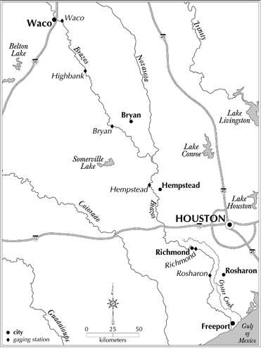
Six gaging stations maintained by the US Geological Survey and cooperating agencies exist along the Brazos River within the study area (; ). Flow records from these stations were analyzed to determine critical or threshold flow levels. The periods of record are variable, with measurements commencing at various dates from 1898 to 1993. The longer records include periods both before and after construction of major dams on the Brazos River upstream of the study area, and on tributaries such as Yegua Creek. Thus separate analyses of mean daily flows were conducted to determine flow regimes characteristic of the past 20 to 30 years. For the Waco, Highbank, Hempstead, and Richmond stations the period analyzed was 1 January 1983 to 31 December 2012. Due to later establishment of the gaging station and missing data, respectively, the periods for the Bryan and Rosharon stations were 1993–2012 and 1984–2012.
Table 1 US Geological Survey gaging stations used in this study. Datum refers to the elevation of the gage above mean sea level (a.m.s.l.); Date is the beginning of regular recording at the site; Slope is derived from digital elevation model data and is the slope used in shear stress and stream power calculations for the site.
Fig. 3 Lower Brazos map showing gaging stations.
The field measurements data for each gaging station was used to identify critical flow levels (http://waterdata.usgs.gov/tx/nwis/measurements). For each available set of measurements, the following data were extracted, along with the date and time: gage height (GH, ft), discharge (Q, ft3 sec-1), width (w, ft), cross-sectional area (A, ft2), and mean velocity (V, ft sec-1), with all values converted to SI units. Mean depth D was calculated as A/w. A representative channel slope S for each gaging station was determined from digital elevation model data using River ToolsTM. For the latter, the upstream slope (channel leading into the gage site) was used. The reach of consistent slope closest to the station was used, provided there was a minimum channel distance of 10 km.
Mean boundary shear stress (N m-2) for each measurement was calculated as
with hydraulic radius R assumed to be equal to D. As width–depth ratios were in all cases >10, this is a reasonable assumption. The specific gravity γ is assumed constant, with a value of 9810.
Specific stream power (ω) is the flow power per unit channel area (W m-2). It is calculated by dividing the cross-sectional stream power by flow width; cross-sectional stream power is the flow power per unit channel length (W m-1).
For each dataset, the following pairwise relationships were examined to identify major changes or inflections in the relationship: GH vs Q, w, D, V, τ, ω; and Q vs w, D, V, τ, ω.
In many cases the GH vs Q relationship (the rating curve) is not consistent over time. In these cases (the Waco, Hempstead, and Richmond gage sites) the measurements from the most recent rating curve indicated in the USGS data were used.
Sediment mobility and channel stability thresholds
Flows associated with the following thresholds were identified:
Threshold shear stress for gravel mobility. This is set at 5.8 N m-2, based on the critical threshold for entrainment of medium gravel in the widely used Shields entrainment function (see discussion in Church Citation2006).
Threshold velocity for mobility of sandy bedforms. A value of 0.35 m s-1 was established by Carling et al. (Citation2000) for the threshold of incipient motion of fluvial sand dunes in the Rhine River. This velocity falls within the range of values for bed stage transitions reported by Robert and Uhlman (Citation2001) from experimental data. The 0.35 m s-1 threshold is above the critical shear velocity for individual grains of sand and very fine gravel given by Fischenich (Citation2001), but consistent with critical entrainment velocities for sand indicated by the Hjülstrom (Citation1939) curve.
Critical specific stream power threshold (10 W m-2). This is based on thresholds of transport and/or channel change at approximately this value identified in several studies of bed load transport, fluvial energy expenditure, and channel morphological change (Williams Citation1983, Ferguson Citation2005, Petit et al. Citation2005, Kale and Hire Citation2007). While three of the studies cited are based mainly on gravel bed rivers, Kale and Hire (Citation2007) is based on an alluvial, sand-bed channel similar to the lower Brazos.
Threshold shear stress for channel instability (bank erosion or failure) for alluvial streams with tight clay or alluvial silt banks (12.68 N m-2; Fischenich Citation2001).
For each of items 1–4 the discharge associated with the critical value was determined for each station, and the associated gage height determined from the rating curve. Estimates of discharges to achieve the thresholds were based on regression equations relating velocity, shear stress, and specific stream power to discharge (in m3 s-1) from the surface water measurements data (as the same slope is used for all stream power and shear stress calculations at a given station, S is not a factor). For example, for Rosharon:
All relationships at all stations had coefficients of determination (R2) of at least 0.8.
The probability for mean daily flows to exceed the identified thresholds (above and below) can be determined visually from graphs presented by Asquith and Heitmuller (Citation2008). However, these may differ from those based on recent decades. The latter were determined from daily mean flows using the standard formula for recurrence interval, RI = (n + 1)/m, where n is the number of daily values, and m is the rank of the discharge. The daily probability is the inverse of RI in days.
Stage and inundation thresholds
Failure to maintain thalweg connectivity is registered at gaging stations as zero flow. This has not been recorded at any of the study sites; minimum discharges were taken as thalweg connectivity flows. Bed inundation flows were estimated based on inflection points in the relationship between width and stage. Typically width increases rapidly with stage at sub-inundation stages, then much more gradually as bank-to-bank inundation occurs. Other inflection points may occur at higher stages as channel inset features are encountered and overbank stages occur.
Key stages for overbank flow and flood effects were determined from National Weather Service (NWS) flood stage information in the advanced hydrologic prediction system. Information for the study area gages is available via the West Gulf River Forecast Center (http://www.srh.noaa.gov/wgrfc/). In addition, digital elevation model (DEM) data for valley bottom areas in the vicinity of gaging stations was examined using River ToolsTM to estimate stages at which inundation of key geomorphic features such as inset floodplains or lower reaches of tributaries is likely to occur. The latter was obtained at a 10 m horizontal resolution from the US Geological Survey Seamless Data Distribution Center (now part of the USGS National Map viewer and download platform; http://nationalmap.gov/viewer.html).
A variety of field surveys and observations, analyses of maps and imagery, and DEM analysis were used to identify and map the river styles (geomorphic zones) of the lower Brazos. This information, described in detail in several technical reports (Phillips Citation2006, Citation2007, Citation2013), was used to identify geomorphic and habitat units and associated threshold flow levels for mobility or fluvial landform inundation. The latter include mid-channel islands, point bar and channel shelf inset floodplains, oxbows and sloughs, mud drapes, floodplain and meander depressions fed primarily by upland runoff and side or subchannels within the geomorphic zones.
RESULTS
Mean and median discharges for the gaging stations, along with one- and 10-year high flows and one-year low flows, are shown in . Mean and median flows increase, as expected, in the downstream direction. Maximum and minimum flows also generally decline, except between the two most-downstream stations. L-statistics from Asquith et al. (Citation2007) are uniformly less than mean and median mean daily flows, indicating relatively low flow variability (very high variability would be indicated by L-values greater than the means or medians). Threshold flows are discussed on a station-by-station basis in the next section, but are summarized below.
Table 2 Discharge (m3 s-1) statistics for lower Brazos River gaging stations, based on mean daily flows over the period indicated. Q1 and Q1 low, respectively, are the high and low flows with a recurrence interval of one year, and Q10 the 10-year flood.
Overbank flow is most common at the Rosharon and Richmond sites, and least common at Bryan and Highbank, with Waco and Hempstead intermediate. Backwater flooding or other forms of channel–floodplain connectivity occurs at sub-flood levels at five gaging stations (all except Rosharon). This is most pronounced at Bryan, where backwater flooding of the Little Brazos begins at a discharge of just over 21% of the NWS flood stage. At Waco, discharges of less than half that associated with flood stage achieve some connectivity with floodplain depressions, and at Hempstead floodplain depressions downstream are connected at flows well below banktop. At Richmond, a discharge of 86% of flood stage results in CFC, while at Rosharon, stages approximating NWS flood levels are required. However, at the latter (and at Richmond), such connectivity increases very rapidly once banktop stages are reached.
Stream power and shear stress are both partly a function of slope, with stream power also directly related to discharge, and shear stress to mean depth. Velocity is indirectly linked to slope and depth, and is also influenced by roughness. Thus the relative thresholds of shear stress (for gravel movement and for channel instability), specific stream power (10 W m-2), and velocity (for sand bedform movement) vary between the stations according to local cross-section and reach variations in channel shape and roughness. At the Waco and Rosharon stations the two shear stress thresholds were the lowest and highest among the four, though at Rosharon both the gravel and sandy bedform mobility levels are attained the vast majority of the time. At Highbank, Bryan, and Richmond the velocity threshold occurs most frequently (lowest discharges), and the channel instability shear stress threshold least often (at Richmond, essentially never). The stream power critical value is associated with higher flows than the gravel mobility shear stress threshold at all sites. The key velocity for sandy bedform motion is associated with lower flows than the stream power threshold for most sites, the exception being Hempstead. At the latter site, both shear stress thresholds are nearly always exceeded (see below).
With respect to correlations among hydraulic variables, in some cases relationships among gage height, discharge, and other variables were consistent over the entire data set of field measurements. In other cases these relationships changed over time, as reflected in changing rating curves.
At lower flows, a threshold could be detected representing flows inundating the entire river bed, as opposed to low flows confined to thalwegs, pools, and other lower areas. This often showed up as a sharp inflection in relationships between gage height and flow width. In the case of Waco, for example (), width increases very rapidly with stage, from about 15–91 m, as stage goes from about 0.6–1.2 m. From there width is relatively constant with stage up to a gage height of about 5.2, where another increase occurs as channel shelves (small inset floodplains) become inundated. Similar phenomena occur at the Highbank, Richmond, and Rosharon stations. The Bryan station shows a rapid increase in width with stage at the lowest stages (up to about 1.8 m), and a more gradual increase thereafter. At Hempstead, width is highly variable, with a total range of 58 to about 104 m. Lower values are associated with gage heights of 3–3.7 m, and widths are consistently around 91 m up to a stage of 7.3–9.1 m, at which point width increases gradually due to drowning of channel shelves.
Fig. 4 Gage height vs flow width relationship for the Waco gaging station. The designated National Weather Service flood stage is 8.23 m.
Results by gaging station
Waco
Threshold flow levels are shown in Appendix . A discharge of about 14 m3 s-1 is necessary to achieve full bed inundation, and about 100 m3 s-1 for the threshold of gravel mobility. Nearly 195 m3 s-1 is required for the threshold velocity for sandy bedform movement, about 237 for the specific stream power threshold, and nearly 300 to achieve the threshold shear stress for channel instability. All of these are sub-banktop flows, and all are associated with daily exceedance probabilities of at least 4% or more. Flow approaching 418 m3 s-1 is associated with stages necessary to inundate small inset floodplains, and of about 585 to trigger channel–floodplain connectivity downstream. These are sub-banktop flows with probabilities of about 2% or more. Threshold stages for flooding have daily exceedance probabilities of <0.01%
Highbank
Highbank is well-named; the river is strongly incised in this vicinity. Observations back to 1913 show only two overbank flow events.
Threshold flows in Appendix show that the relatively steep slope and flow confinement leads to relatively high velocities, and sandy bedform mobility is associated with a discharge of only about 10 m3 s-1. However, this would occur only in the thalweg. Velocity continues to increase rapidly with gage height up to 1.8 m (140 m3 s-1) before increasing more slowly and erratically with discharge. The gravel mobility threshold is only slightly greater than 140, and ω = 10 W m-2 occurs at about 228 m3 s-1. The estimated channel instability threshold is linked to a discharge of about 417 m3 s-1. All of these have occurred at least 4% of the time in the historical record. Because of the high banks and incised channel, stages necessary to inundate inset floodplains and valley bottom depressions are rare (p < 0.01), and flood stage is even rarer.
Bryan
The gaging station is near the confluence with the Little Brazos River, and the Little River also joins the Brazos between the Highbank and Bryan stations. Bed inundation occurs at <13 m3 s-1, and sandy bedform mobility at about 60. The threshold for gravel mobility occurs at about 120 m3 s-1, which is achieved in mean daily flows about 27% of the time. The specific stream power threshold and the initiation of backwater flooding in the Little Brazos occur at similar discharges that occur about 8% of the time. More significant backwater flooding of the Little Brazos occurs at a discharge >1100 m3 s-1. NWS flood stages are rarely achieved (p < 0.01), and only two stages above the ‘moderate flooding’ stage have ever been recorded.
Hempstead
Between the Bryan and Hempstead stations two major tributaries, the Navasota River and Yegua Creek, join the Brazos. The Hempstead station occurs within a bedrock controlled section of the valley, and slopes are the steepest of any gaging station. Width–depth ratios, though all >10, are also significantly lower than at other stations. As a result, nearly all discharges exceed the thresholds for gravel mobility and channel instability of cohesive sediment channels, though actual instability is not prevalent because of the bedrock control. Only four of about 850 field measurements show shear stresses <10 N m-2.
For discharges up to about 47 m3 s-1, depth increases rapidly with discharge, with the relationship flattening at this point. The ω = 10 and sandy bedform thresholds are at 90 and 132 m3 s-1, respectively. At about 511 m3 s-1 flooding of inset channel shelves occurs, and flood stage requires >2367, with daily mean flows reaching this level about 0.1% of the time (Appendix ).
Richmond
Discharge increases only slightly between Hempstead and Richmond, as there are no large tributaries between the two stations. Also within this reach, the Bessie’s Creek/Oyster Creek drainage (occupying the former Brazos River channel abandoned after an avulsion about 1,500 years ago; Taha and Anderson (Citation2008)) conveys some of the runoff that would otherwise contribute to Brazos River flow. Flood peaks are somewhat depressed because at flows above about 2100 m3 s-1, cross-valley flow to the Oyster Creek system occurs.
The vertical datum of the Richmond gage is <9 m a.s.l., and the slope is about 1/10 that at Hempstead. Threshold discharges for sandy bedform movement and gravel mobility are correspondingly higher, associated with flows of approximately 180 and 450 m3 s-1, respectively. To achieve the channel instability threshold shear stress of 12.68 N m-2 with a slope of 0.0001, a depth of 12.93 m would be required. Nearly 980 field measurements show a maximum depth of 11 m. Extrapolation of the discharge vs mean depth relationship indicates a flow approaching 2830 m3 s-1 would be required to achieve the critical depth—but as cross-valley flow occurs at discharges of 2113 or greater, this is extremely unlikely.
At a stage of about 6.4 m (~450 m3 s-1) the rate of velocity increase with flow is somewhat reduced, apparently due to increased roughness on upper banks. Channel floodplain connectivity and flood stage occur at about 2100 and 2300 m3 s-1 (Appendix ).
The relationship between discharge and sediment transport at the Richmond gage was analyzed by Hudson (Citation2010), who identified a discharge of about 1500 m3 s-1 as the ‘most effective’ discharge. The latter is defined as that which transports the greatest total mass of sediment over time.
Rosharon
Mean and annual maximum flows increase only slightly from Richmond to Rosharon, and the 10-year flood value, and annual minimum actually decrease. Asquith et al. (Citation2007) show that the L-scale increases somewhat, indicating greater variability at Rosharon. The datum of the Rosharon gage is at sea level, and overbank flows in the Richmond-Rosharon reach and downstream are more common than upstream of Richmond. Flow into the Oyster Creek system, and water storage in floodplain depressions is common at discharges of about 1550 m3 s-1 or greater, accounting for the diminution of peaks in this reach.
The low elevation of the river bed at Rosharon ensures that bed inundation is nearly constant, and the consistently high mean depths (average: 3.43 m) coupled with a slope approaching that of the Bryan and Waco stations ensures that the thresholds for gravel and sandy bedform movement are nearly always achieved (Appendix ). The specific stream power of 10 W m-2, however, requires a discharge of nearly 500 m3 s-1, and the channel instability threshold occurs at about 1000 m3 s-1.
Critical flow stages
Thresholds associated with thalweg connectivity, bed inundation, high sub-banktop, and overbank flows in the lower Brazos River are summarized in .
Table 3 Estimated discharges (m3 s-1) for thresholds of thalweg connectivity (TC), bed inundation (BI), high sub-banktop (HSB), channel–floodplain connectivity (CFC), and overbank flooding (OvB).
Thalweg connectivity is maintained across the entire range of historic flows in the lower Brazos. No evidence of near-zero or negative (upstream flux) velocities was discovered in the surface water measurements for any of the Brazos gaging stations examined in this study, or other evidence of discontinuous flows. A study of the occurrence of zero-flow at Texas gaging stations also did not identify any zero-flow events in the lower Brazos (Asquith et al. Citation2007).
Bed inundation stages occur nearly always in the lowermost reaches (Richmond and Rosharon gaging stations) and at the Highbank station, and at least 85 to 90% of the time at Hempstead and Bryan. At Waco, discharges necessary to achieve bed inundation are exceeded about 77% of the time.
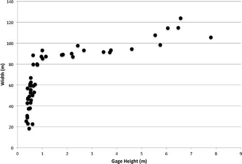
At the gaging station sites banktop flow stages are based on National Weather Service flood stages. The high range of high sub-banktop flows is therefore slightly less than the discharge associated with flood stage. The lower range of high sub-banktop (‘high’ identifies flows above mean or median discharges, and fully inundating the lower banks) was estimated from inflection points of discharge vs width relationships. For example, at the Rosharon gaging station the discharge vs width relationship reaches a width of about 122 m at a discharge of a bit less than 85 m3 s-1 (), and then levels off before rising again at banktop flow levels. This indicates full inundation of the lower banks and is taken as the lower range of the higher sub-banktop flows.
Fig. 5 Discharge–width relationship for the Rosharon gaging station. Straight line indicates the identified lower end of high sub-banktop flows. The graph includes all field measurement data; the most recent rating curve suggests the inflection point is associated with a discharge of about 84 m3 s-1.
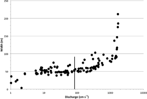
A wide range of flows can occur between higher and lower sub-banktop flows, ranging by a factor of nearly twofold at Rosharon to more than fivefold at Hempstead (). Note, however, that even the lower end of high sub-banktop flows are greater—often much greater—than mean or median discharges.
The lower Brazos River is mainly incised, and in many areas alluvial surfaces have developed within the incised banks. The terminology and specific nature of these surfaces varies, including point bars, floodplains or inset floodplains, and channel shelves. The elevation of the more-or-less flat upper surfaces of these features in incised channels is (in humid-regional perennial alluvial streams) associated, or assumed to be associated, with discharges with a recurrence interval of 1 to 2 years (Harrelson et al. Citation1994, Stream Team Citation2012). The elevation of these inset features is often referred to as ‘bankfull’ flow for strongly incised or underfit channels. Thus, use of the term ‘banktop’ in this report to refer to the actual morphological channel boundaries.
Heitmuller (Citation2014) showed that sub-banktop features are associated with the 1- to 2-year (annual series) flow stage in the lower Brazos River. Field observations are consistent with his analysis. At five sites between Waco and the US 79/190 bridge upstream of Bryan, field measurements showed elevation differences between the top of inset floodplains or upper point bar surfaces to be (in upstream-downstream order) 2.65, 4.40, 4.00, 2.25, and 6.00 m. From Bryan to Brazoria, a number of field measurements conducted in conjunction with earlier projects (Phillips Citation2006, Citation2007) showed differences of 2 to 8 m in elevation between inset floodplain surfaces and morphological banktops. Thus stages associated with ‘bankfull’ as often defined are considerably less than those necessary to reach the morphological banktops.
Channel–floodplain connectivity
Hydrological connectivity between the active river channel and the floodplain—particularly depressional areas—can occur via overbank flooding, crevasse-type flow through gaps in natural levees, activation of high-flow subchannels, backwater flooding of tributaries, and groundwater flux. Flows or stages necessary to initiate channel–floodplain connectivity are less than overbank flood stage at all gaging stations, and occur within the range of high sub-bankfull discharge at all sites except Highbank ().
Overbank flood flows are associated with exceedance of the channel capacity and overtopping of natural levees and the morphological bank tops. An upstream-downstream gradient exists in the frequency of such flows. At Waco and Highbank, the probability of mean daily flows equalling or exceeding this level is <0.01%, and at Bryan and Hempstead <0.1%. At Richmond this rises to 0.1%; at Rosharon to 1.7%.
Force-resistance thresholds
Magilligan (Citation1992) suggested a specific stream power of about 300 W m-2 as a general threshold for catastrophic channel change, and subsequent work has confirmed this as a good approximate value. The historical record of the lower Brazos does not suggest that this has been approached. Thus this threshold represents an extreme event that is likely to be beyond the influence of environmental flow management. The 10 W m-2 specific stream power threshold used here reflects the approximate value at which inflection points occur in relationships between ω and sediment transport—that is, transport increases slowly with stream power up to about 10, and more rapidly thereafter (Williams Citation1983, Ferguson Citation2005, Petit et al. Citation2005, Kale and Hire Citation2007).
The bed of the lower Brazos varies, but is dominantly a sand-bed channel. The critical shear stress for entrainment of individual sand grains is quite low; more relevant is the movement of the sand bedforms (ripples, dunes, and antidunes) that provide key hydraulic and habitat elements. Gravel is present in all but the lowermost reaches of the lower Brazos, much of it delivered by erosion of Pleistocene alluvial terraces along the valley walls and within the valley bottom (Phillips Citation2007).
The guide produced by Fischenich (Citation2001) for design of stable channels identifies a threshold of bank failure shear stress of 12.68 N m-2 for alluvial streams with tight clay or alluvial silt banks. This is one of the thresholds calculated for this study based on the predominant bank types in the lower Brazos. Of the 20 soil types commonly occurring along the lower Brazos River banks, 15 have subsoil textures of silt loam or finer (Phillips Citation2013). However, there exists considerable within-reach variability in bank resistance.
Estimated discharges to achieve these thresholds are shown in . The bank instability threshold is generally highest, except at Hempstead, where the confined valley setting and consistently high depths result in high calculated shear stresses. The velocity threshold is lowest of the thresholds at a given station in three cases (Highbank, Bryan, Richmond), and highest at Hempstead. The gravel mobility shear stress threshold is lowest at the Waco, Hempstead, and Rosharon gages.
Table 4 Discharges (m3 s-1) associated with key thresholds of velocity (V), shear stress (τ), and specific stream power (ω).
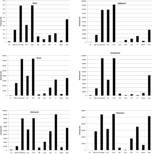
shows the relative thresholds described above for each gaging station, along with the median daily discharge and the median annual maximum daily discharge. Note the differing scales on the vertical axes. The thalweg connectivity thresholds are very low at all sites and are not shown. The higher end of the high sub-banktop discharge is near the overbank flow threshold in all cases, by definition.
Fig. 6 Graphical comparison of critical thresholds, along with mean and the average annual maximum daily flows, for lower Brazos River gaging stations. Discharges are shown in ft3 sec-1, the units of measurement and data dissemination, to assist managers. BI: bed inundation; HSB: high sub-banktop; CFC: channel–floodplain connectivity; Sbf: sandy bedform mobility; Grav: gravel mobility; SSP: specific stream power; CI: bank instability. Thalweg connectivity thresholds are too low to be shown on the graphs. Note variation in the y-axis scale.
DISCUSSION
Critical flow levels and geomorphic features
As mentioned earlier, frequent bed-inundation flows are necessary to remove mud drapes from the channel bed and lower banks. This appears to be the case at present, but a significant reduction of these flows could result in fine sediment accumulations and benthic habitat degradation. Maintenance of the sand/gravel islands between Waco and Bryan requires flows significantly above the bed inundation stage, and sufficient for sandy bedform mobility (V ≥ 0.35 m s-1) and gravel transport (τ ≥ 5.8 N m-2).
Inundation of inset floodplains, channel shelves, and upper point bars is associated with the low end of high sub-bankfull flows, which should occur more-or-less annually. Oxbows and sloughs, which are often critical wetland and aquatic habitats, may be quite variable with respect to their dependence on river discharges, as discussed earlier. At all gaging stations, stages less than the upper end of high sub-banktop flows are sufficient.
Hydrologic and geomorphic thresholds
Hydrologic thresholds in this case correspond to flow levels necessary to achieve thalweg connectivity, bed inundation, and channel–floodplain connectivity. They also include banktop and high and low sub-banktop flows. Thalweg connectivity is critical for survival and movement of some aquatic fauna, but this minimal flow level is constantly maintained in the lower Brazos River (though not necessarily in the upper basin, during droughts). The bed inundation flows are required for long-term maintenance of aquatic habitats, and to remove and prevent the build-up of excess fine sediments. Bed inundation flows are not sufficient for mobility of larger particle sizes, however. Interestingly, CFC is achieved at stages well below banktop or overbank even in this incised system due to occupation of high-flow sub-channels and backwater flooding of tributaries.
The estimated geomorphic thresholds can be achieved by the lower range of high sub-banktop flows at three of the six stations, and all but bank stability at two others. At the exception (Richmond), estimated geomorphic thresholds other than sand mobility are rarely achieved due to low slope.
Median discharges (50% daily recurrence probability) exceed none of the geomorphic thresholds at one station (Waco), and all at another (Hempstead). At three sites (Highbank, Bryan, Richmond), median flows are sufficient only for the sandy bedform criterion.
Shear stress and stream power
Flow velocity is a complex function of energy grade slope, flow depth or hydraulic radius, and roughness or frictional resistance. However, predictive diagrams can be developed as predictive aids for identifying potential threshold crossings of shear stress and stream power.
shows shear stress vs depth relationships for several orders of magnitude of slope. Lower Brazos slopes are predominantly in the range of 0.0001 to 0.001, but locally steeper and gentler gradients occur. Critical stream power thresholds are identified in terms of specific stream power, ω = Ω/w, where Ω is cross-sectional stream power. Ω vs Q relationship was also calculated for a range of slopes, as shown in . The cross-section stream power can be divided by channel width at a site of interest to determine the specific stream power.
Fig. 7 Shear stress/mean depth relationship for several slope gradients typical of the study area. Threshold shear stress values used in this study are highlighted.
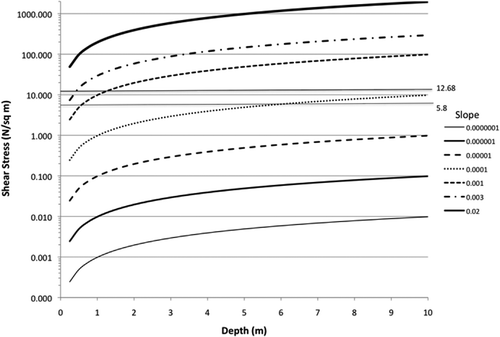
Fig. 8 Cross-sectional stream power vs discharge relationship for several slope gradients typical of the study area.
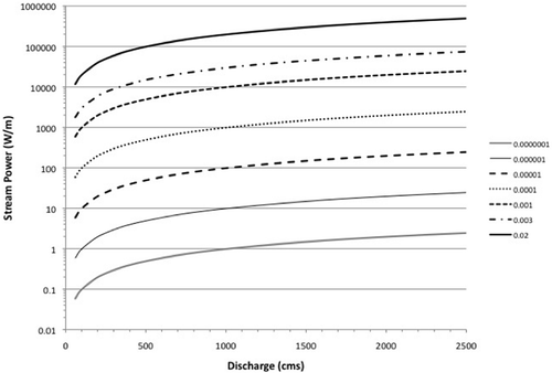
and are useful tools for estimating thresholds, but also show how much variability may exist. Even considering just the central portion of the graphs (i.e. ignoring the high and low slopes), there are several orders of magnitude of difference in stream power and shear stress for a given discharge or depth, depending on local energy grade slopes.
Complexity of hydraulic relationships
and Appendix 1 show that at some stations the critical discharge for sandy bedform mobilization is greater than that for gravel transport. As sandy bedform movement involves movement of sand grains, which are mobilized at much lower shear stresses than gravel, this seems counterintuitive. To some extent this may represent both epistemic uncertainty with respect to sediment transport, and inherent variability and uncertainty in specifying a single threshold value. Another consideration is the complexity of at-a-station hydraulic geometry, whereby the relative importance of width, depth, velocity, and roughness in accommodating changes in imposed flows is both highly variable and dynamically unstable (Phillips Citation1990, Citation1991). Further, shear velocity rather than mean (depth-averaged) velocity determines mobilization of bed material particles. The relationship between mean and shear velocities depends in part on the height of roughness elements relative to flow depth. Thus the velocity threshold derived for a given location may not be valid for other sites.
There is also well-known uncertainty in gravel entrainment, associated not only with variability of size (particle diameter), which is reflected in the Shields entrainment function, but also by other factors such as bedforms, clast shape, particle embedding, orientation, and packing, and bed armoring.
The results here should therefore be understood as demonstrating variation in discharges and stages associated with benchmark values of shear stress, stream power, and velocity. While these benchmark values were selected to represent estimated thresholds of key processes, the variation is demonstrated only for the hydraulic parameters, and not necessarily for the processes themselves.
Further, as in any river—particularly alluvial rivers—the channels are dynamic, and the stages, discharges, and frequencies of various critical flows may change over time. In the lower Brazos, for instance, channel changes in recent decades have reduced CFC and overbank flows (Heitmuller Citation2014).
Variability of critical flows
graphically summarizes the various thresholds for each of the gaging stations. Other than the closeness of the higher high sub-bankfull and overbank flow levels, in most cases these vary substantially. The lower thresholds (bed inundation, sandy bedform and gravel mobility) often differ from the middle and upper thresholds by an order of magnitude. The banktop flow appears to otherwise have no special significance, other than its definitional importance as a flooding threshold. The designation of ‘bankfull’ flows in incised channels is often based on the upper surface of point bars and inset floodplain features. In this would generally fall somewhere between the “low HSB” and “CFC” levels. The bankfull level, thus defined, has variable relationships to the other key thresholds.
At all stations the thresholds for gravel and sandy bedform mobility and channel instability—indeed all thresholds other than banktop—are less than flows with a one-year recurrence interval, banktop, or bankfull as commonly defined. At the lowermost stations (Richmond, Rosharon) bankfull and morphological banktop flow are consonant, with daily exceedence probabilities of 0.1 and 1.7%, respectively. If daily recurrence intervals are converted to annual by dividing by 365, the daily probabilities of 1- to 2-year flows would be 0.14 to 0.27% (though annual recurrence intervals are often calculated based on an annual maximum flood series rather than daily flows).
At Waco and Hempstead, where nearby inset floodplains approximate bankfull flow stages, inundation of these features occurs with discharges having daily probabilities of about 3 and 11%, respectively. All other thresholds, except banktop stage, occur more frequently at lower discharges (Appendix). At Bryan, where a reliable estimate of bankfull has not been made, all thresholds except banktop have a daily probability of 1% or greater.
Overall, the results suggest that no single flow level is dominant in hydrological or geomorphic dynamics, and that the frequency of a given threshold varies considerably even along a single river. This suggests that instream flow programs may need to prioritize not only particular flow thresholds according to specific management goals, but also specific stream reaches or sections, since achieving a given threshold at one site may not have the same effect upstream or downstream.
CONCLUSIONS
Threshold stages and discharges were identified for six Brazos River gaging stations corresponding to thalweg connectivity, bed inundation, low and high ranges of high sub-banktop flows, channel–floodplain connectivity (CFC), and overbank flooding. Channel–floodplain connectivity occurs at flows significantly below flood levels throughout the study area. Higher sub-banktop and CFC flows are uniformly greater than mean or median flows, and in most of the study area flows necessary to achieve CFC are less than typical annual maximum daily mean flows. Minimum discharges corresponding to estimated thresholds for sandy bedform mobility, medium gravel mobility, specific stream power, and cohesive-bank channel instability thresholds have variable relationships to mean, median, and maximum flows in the historical record.
While some river science and management tasks require specification of a design or reference discharge, critical flows may be quite different in magnitude and frequency of occurrence based on different hydrological, geomorphological, and ecological criteria. The thresholds for thalweg connectivity are essentially always maintained (based on the historical flow record) in the lower Brazos, but discharges somewhat in excess of bed inundation are required to prevent excessive silt and clay accumulation. In most cases, thresholds for mobility of channel sediments are regularly exceeded, and thresholds for channel instability are mostly exceeded sufficiently often to preserve the character of the Brazos as an actively laterally migrating channel. Channel–floodplain connectivity occurs at flows significantly below flood levels throughout the study area. Higher sub-banktop and CFC flows are uniformly greater than mean or median flows, and in most of the study area flows necessary to achieve CFC are less than typical annual maximum daily flows. Overall, results support the idea that multiple flow levels and ranges are necessary to create and maintain the hydrological, geomorphological, and ecological characteristics of rivers, and that no single stage or discharge is of paramount importance. Additionally, due to non-systematic spatial (along-stream) variation in threshold flow levels, achieving target flows at one reach or station may not result in attainment of those targets in adjacent reaches.
Disclosure statement
No potential conflict of interest was reported by the author(s).
Acknowledgements
Helpful comments from Mark Wentzel helped improve the final product. Jeff Levy and Dick Gilbreath of the University of Kentucky GIS and Cartography laboratories assisted with assembling the GIS databases and with preparing figures. Frank Heitmuller and an anonymous referee provided helpful critiques of an earlier draft.
Additional information
Funding
References
- Asquith, W.H. and Heitmuller, F.T., 2008. Summary of annual mean and annual harmonic mean statistics of daily mean streamflow for 620 U.S. Geological Survey streamflow-gaging stations in Texas through water year 2007. US Geological Survey Data Series 372. Available from: http://pubs.usgs.gov/ds/372/ [Accessed 30 June 2015].
- Asquith, W.H., Vrabel, J., and Roussel, M.C., 2007. Summary of annual mean, maximum, minimum and L-scale statistics of mean daily streamflow for 712 U.S. Geological Survey streamflow-gaging stations in Texas through 2003. US Geological Survey Data Series 248. Available from: http://pubs.usgs.gov/ds/2007/248/ [Accessed 30 June 2015].
- Carling, P.A., et al., 2000. The morphodynamics of fluvial sand dunes in the River Rhine, near Mainz, Germany. I. Sedimentology and morphology. Sedimentology, 47, 227–252. doi:10.1046/j.1365-3091.2000.00290.x
- Church, M., 2006. Bed material transport and the morphology of alluvial river channels. Annual Review of Earth and Planetary Sciences, 34, 325–354. doi:10.1146/annurev.earth.33.092203.122721
- Doyle, M.W., et al., 2005. Effective discharge analysis of ecological processes in streams. Water Resources Research, 41, W11411. doi:10.1029/2005WR004222.
- Ferguson, R.I., 2005. Estimating critical stream power for bedload transport calculations in gravel-bed rivers. Geomorphology, 70, 33–41. doi:10.1016/j.geomorph.2005.03.009
- Fischenich, C., 2001. Stability Thresholds for stream restoration materials. EMRRP Technical Notes Collection. Vicksburg, MS: US Army Engineer Research and Development Center, ERDC TN- EMRRP-SR-29. Available from: http://el.erdc.usace.army.mil/elpubs/pdf/sr29.pdf [Accessed 2 December 2013].
- Harrelson, C.C., Rawlins, C.L., and Potyondy, J.P., 1994. Stream channel reference sites: an illustrated guide to field technique. Fort Collins, CO: USDA Forest Service, Rocky Mountain Forest and Range Experiment Station, General Technical Report RM–245.
- Heitmuller, F.T., 2011. Magnitude and frequency relations of bankfull flows and bed material entrainment in the Llano River watershed, central Texas, USA. Physical Geography, 32, 533–560. doi:10.2747/0272-3646.32.6.533
- Heitmuller, F.T., 2014. Channel adjustments to historical disturbances along the lower Brazos and Sabine Rivers, south-central USA. Geomorphology, 204, 382–398. doi:10.1016/j.geomorph.2013.08.020
- Hjülstrom, F., 1939. The transportation of detritus by moving water. Part 1. Transportation. In: P.D. Trask, ed. Recent marine sediments. Tulsa, OK: American Association of Petroleum Geologists, Special Publication 10, 5–31.
- Hudson, P.F., 2010. Floodplain lake formation and dynamics in the lower reaches of large Texas coastal plain rivers: Brazos, Guadalupe, and San Antonio Rivers. Austin: Texas Water Development Board, report no. 0600010583. Available from: http://www.twdb.texas.gov/publications/reports/contracted_reports/index.asp [Accessed 1 July 2015].
- Kale, V.S. and Hire, P.S., 2007. Temporal variations in the specific stream power and total energy expenditure of a monsoonal river: the Tapi River, India. Geomorphology, 92, 134–146. doi:10.1016/j.geomorph.2006.06.047
- King, J., Brown, C., and Sabet, H., 2003. A scenario-based holistic approach to environmental flow assessments for rivers. River Research and Applications, 19, 619–639. doi:10.1002/rra.709
- Lenzi, M.A., Mao, L., and Comiti, F., 2006. Effective discharge for sediment transport in a mountain river: computational approaches and geomorphic effectiveness. Journal of Hydrology, 326, 257–276. doi:10.1016/j.jhydrol.2005.10.031
- Liu, C., et al., 2011. An instream ecological flow method for data-scarce regulated rivers. Journal of Hydrology, 398, 17–25. doi:10.1016/j.jhydrol.2010.11.026
- Magilligan, F.J., 1992. Thresholds and the spatial variability of flood power during extreme floods. Geomorphology, 5, 373–390. doi:10.1016/0169-555X(92)90014-F
- Meitzen, K.M., et al., 2013. Geomorphology within the interdisciplinary science of environmental flows. Geomorphology, 200, 143–154. doi:10.1016/j.geomorph.2013.03.013
- Petit, F., et al., 2005. Critical specific stream power in gravel-bed rivers. Geomorphology, 69, 92–101. doi:10.1016/j.geomorph.2004.12.004
- Phillips, J.D., 1990. The instability of hydraulic geometry. Water Resources Research, 26, 739–744. doi:10.1029/WR026i004p00739
- Phillips, J.D., 1991. Multiple modes of adjustment in unstable river channel cross-sections. Journal of Hydrology, 123, 39–49. doi:10.1016/0022-1694(91)90067-R
- Phillips, J.D., 2002. Geomorphic impacts of flash flooding in a forested headwater basin. Journal of Hydrology, 269, 236–250. doi:10.1016/S0022-1694(02)00280-9
- Phillips, J.D., 2006. Geomorphic context, constraints, and change in the lower Brazos and Navasota Rivers, Texas. Austin: Texas Instream Flow Program, Report No. 0605483564. Available from: http://www.twdb.texas.gov/publications/reports/contracted_reports/index.asp [Accessed 1 July 2015].
- Phillips, J.D., 2007. Field data collection in support of geomorphic classification of in the lower Brazos and Navasota Rivers. Phase 2 of the Project: Geomorphic context, constraints, and change in the lower Brazos and Navasota Rivers, Texas. Austin: Texas Instream Flow Program, Report No. 0604830639. Available from: http://www.twdb.texas.gov/publications/reports/contracted_reports/index.asp [Accessed 1 July 2015].
- Phillips, J.D., 2013. Flow modifications and Geomorphic Thresholds in the lower Brazos River. Austin: Texas Instream Flow Program, Report No. 1248311367. Available from: http://www.twdb.texas.gov/publications/reports/contracted_reports/index.asp [Accessed 1 July 2015].
- Roach, K.A., 2013. Texas water wars: how politics and scientific uncertainty influence environmental flow decision-making in the Lone Star state. Biodiversity Conservation, 22, 545–565. doi:10.1007/s10531-013-0443-2
- Robert, A. and Uhlman, W., 2001. An experimental study on the ripple-dune transition. Earth Surface Processes and Landforms, 26, 615–629. doi:10.1002/esp.211
- Stream Team (U.S. Forest Service). 2012. Identifying bankfull stage in the eastern and western United States. USDA Forest Service, Stream Systems Technology Center. Available from: http://stream.fs.fed.us/publications/videos.html#eastandwest [Accessed 1 July 2015].
- Surian, N., et al., 2009. Morphological effects of different channel-forming discharges in a gravel-bed river. Earth Surface Processes and Landforms, 34, 1093–1107. doi:10.1002/esp.1798
- Taha, Z.P. and Anderson, J.B., 2008. The influence of valley aggradation and listric normal faulting on styles of river avulsion: a case study of the Brazos River, Texas, USA. Geomorphology, 95, 429–448. doi:10.1016/j.geomorph.2007.07.014
- Williams, G.P., 1983. Paleohydrological methods and some examples from Swedish fluvial environments. I. Cobble and boulder deposits. Geografiska Annaler. Series A, Physical Geography, 65, 227–243. doi:10.2307/520588
Appendix
Threshold flow levels for lower Brazos River gaging stations Waco (), Highbank (), Bryan (), Hempstead (), Richmond () and Rosharon (). Items shown in bold represent the identified stage or discharge threshold value and units, with other values determined from the rating curve and/or unit conversions.
Table A1 Threshold flow levels for Brazos River at Waco: USGS station number 08096500.
Table A2 Threshold flow levels for Brazos River at Highbank: USGS station number 08098290.
Table A3 Threshold flow levels for Brazos River at Bryan: USGS station number 08108700.
Table A4 Threshold flow levels for Brazos River at Hempstead: USGS station number 08111500.
Table A5 Threshold flow levels for Brazos River at Richmond: USGS station number 08114000.
Table A6 Threshold flow levels for Brazos River at Rosharon: USGS station number 08111500.