
ABSTRACT
The Sebkhet El Behira–Garaat El Majdoul multilayer aquifer system is composed of Mio-Plio-Quaternary and Oligocene groundwater exploited in Sidi Bouzid and Kairouan governorates. Annual withdrawal volumes from El Behira Oligocene groundwater were about 0.37 hm3 in 2005 and 0.36 hm3 in 2008. The present study of the Oligocene reservoir in the Sebkhet El Behira–Garaat El Majdoul basin is based on various data including 2D seismic sections, petroleum wells, field geological cross-sections and geochemical analysis. The gathered data allowed us to establish the tectonic framework and to define its influence on the structure of the aquifers seated in the deep Oligocene sandstone reservoirs. Three Oligocene sub-basin aquifers are defined showing different depth, thickness and petrophysical characteristics: lower salinity (<1.5 g/L) and higher porosity (30%). Two field sections in the northern and in the southern parts of Cherahil anticline exhibit the presence of four to five sandstone levels. The anticlines limit the Sebkhet El Behira–Garaat El Majdoul basin. In addition, the morphostructural configuration controls the piezometry of underground flows in the Oligocene and Mio-Plio-Quaternary unconfined aquifers.
Editor D. Koutsoyiannis; Associate editor M. Besbes
1 Introduction
In the region of Kairouan–Sidi Bouzid (central Tunisia), agricultural and industrial activities have considerably increased in recent years and important development and demographic expansion are at the origin of a rapid increase in water demand.
This situation has induced intensive exploitation of shallow Mio-Plio-Quaternary aquifers. Therefore, the necessity to identify new groundwater resources has become urgent. In this study we attempt to identify and characterize new deep hydrogeological reservoirs by a new geophysical approach.
Several similar studies published in recent years, undertaken in Sahel eastern Tunisian bordering regions (Bédir Citation1988, Khomsi et al. Citation2004, Citation2012, Bédir et al. Citation2005, Citation2008, Citation2012), have demonstrated and highlighted by new integrated geological, geophysical and geochemical approaches the direct relationship between the distribution of deep water reservoirs and characteristics of Oligocene and Neogene sandstones and the tectonic and sedimentary basin structuring.
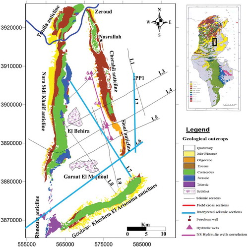
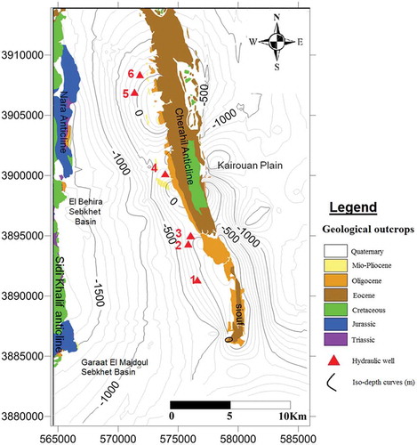
The study area of the Sebkhet El Behira–Garaat El Majdoul basin is situated in central Tunisia and is characterized by a triangular form. This plain is limited in the west by the Nara-Sidi Khalif anticlines, which are 60 km long, trending N–S and extending to the north to the El Houareb anticline, constituting the so-called N–S axis (Burrollet Citation1956). In the eastern part, it is limited by the NW–SE Cherahil and Kabbara anticlines. The southeastern boundary is represented by the SW–NE Goubrar–Khechem El Artsouma anticline. This area is located between the 3865000 and 3925000 parallels and between the 560000 and 585000 meridians and covers an area of 920 km2.
The Sebkhet El Behira–Garaat El Majdoul syncline zone is one of the Tunisian semi-arid areas located in the northeastern part of central Tunisia in the Wadi Zeroud watershed.
The annual average precipitation is less than 242 mm and the annual evapotranspiration is very high; it may reach 1737 mm. Based on previous hydrogeological studies, the key aquifers of central Tunisia are Plio-Quaternary sands and siltstones, Miocene sandstones, Oligocene sandstones, Eocene fractured limestones and Upper Cretaceous fractured limestones (Senonian). In the study area, groundwater seems to be trapped within Plio-Quaternary, Oligocene and Eocene reservoirs. In terms of quality and renewable water resources, the Miocene and Oligocene aquifers are believed to be the most important ones (DGRE Citation2005, Citation2008). They are used to satisfy the local needs for domestic water supply and irrigation and as drinking water for the Sahel and Sfax governorates.
The Oligocene sandstone reservoirs of the Fortuna Formation (Oligocene–Lower Miocene) are the most widespread levels in the northern part of central Tunisia and especially in the Kairouan governorate (Oueslatia, Bou Hafna, Haffouz, Chérichira, Ain Beidha, Serdja, Bou Morra, and Sisseb-El Alem). They consist of two levels with different hydrogeological characteristics: a lower impermeable level formed by marine facies, which is formed of alternating sandstone and clay; and an upper level formed by continental facies of coarse sandstones, sometimes massive, porous and permeable, constituting the main groundwater reservoir.
The subsurface data including seismic sections and petroleum wells combined with outcrop data will highlight the different hydrogeological sub-basins and the main structures of the Sebkhet El Behira–Garaat El Majdoul basin and Oligocene horizons.
2 Geological setting
The study area (N–S axis) has had a tectonic palaeo-lineament of unstable bed rocks since the Jurassic period (Burrollet Citation1956, Bédir Citation1995, Abbes Citation2004, Ouali Citation2007) (). This deep fracturing progressed into a major fault relay throughout geological history until the last phase of Tortonian–Villafranchian folding (Burrollet Citation1956, Boukadi Citation1994, Bédir Citation1995, Abbes Citation2004, Ouali Citation2007, Khomsi et al. Citation2006). It is characterized by a meridional direction. The complexity of this structure is due to the originality of its position at the boundary between two geodynamic domains: the central Atlas to the west and the Sahel plain to the east, which have evolved differently over geological times (Ouali Citation2007).
Figure 1. Location map of the studied area showing geological outcrops, field cross-sections, seismic lines and correlation wells.
The actual architecture of these structures is therefore the result of a sequence of several tectonic phases characterized either by an extensional regime of Tethyan Triassic, Jurassic and Lower Cretaceous rifting, or by a compressional regime of Late Cretaceous to Eocene Pyrenean phase and Alpine and Neogene Atlasic phase (Truillet et al. Citation1981, Abbes Citation1983, Yaïch Citation1984, Ouali et al. Citation1987, Boukadi Citation1994, Bédir Citation1995, Soussi Citation2000, Bouaziz et al. Citation2002, Abbes Citation2004, Khomsi et al. Citation2006, Ouali Citation2007, Zouaghi Citation2008).
The southeastern side of the basin represents the boundary of the study area, formed by the Goubrar–Khechem El Artsouma anticline, which is a reverse faulted asymmetrical fold strongly spilled to the southeast. Along the main SW–NE fault, the geological layers of the southeast flank are verticalized and even reversed, whereas on the northwest side, the dip of layers is less pronounced (<45°). The latter plunge gently in the Ouled Haffouz basin, which is a complex syncline structure.
The eastern side of the basin is limited by the Siouf and the Cherahil anticlines, which are a very pronounced and massive outcrop constituting the northern periclinal flank of the Cherahil anticline (Yaïch Citation1984, Ouali Citation2007). The core of the Cherahil–Siouf structures is occupied by the Campanian–Maastrichtian Abiod Formation, involved in the folding along the N10 to N20 direction; these folds are in echelon over a shearing fault trending N155.
3 Material and methods
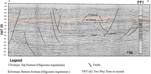
Study of the Oligocene reservoir (Fortuna Formation) in the Sebkhet El Behira–Garaat El Majdoul basin is mainly based on seismic interpretation of 2D seismic lines (11 seismic lines) acquired from several oil companies and provided by the ETAP Company. Seismic calibration was performed using the PP1 petroleum well which intersects with seismic lines L1 and L2 (). Seismic horizons and facies have been linked using a time–depth curve. To characterize this reservoir, two geological field sections were established in order to identify the sandstone levels (Houatmia Citation2010, Houatmia et al. Citation2011, Citation2012). Finally a hydrogeological study of Oligocene groundwater highlights the importance of this aquifer.
Figure 2. Seismic section (L2) calibrated to the PP1 petroleum well showing Oligocene faulted horizon extension and thickness variations according the basin structuring in subsiding synclines and resistant anticlines.
4 Results
4.1 Identification of the Oligocene reservoirs
The Oligocene section exposed along the N–S Touila Goubrar anticline is represented by two parts, the base is composed of sandstones that alternate with sandy limestones and clays containing a marine fauna, and an upper continental part largely dominated by coarse sand to quartz dragees and silicified wood fragments (Abbes Citation1983, Yaïch Citation1997). These sedimentary series exposed at Jebel Siouf and west of Nara-Axis Touila anticlines show important thickness variations, ranging from 100 to 130 m in the Cherahil anticline where the marine base part is absent, and from 230 to 300 m in the Siouf and in the northwest of Khechem El Artsouma anticlines (Rabhi Citation1999, Zagrani Citation1999, Abbes Citation2004, Ouali Citation2007). To the west of Gridjima Hallouf and to the northeast of Khechem El Artsouma anticlines, these levels present reduced thickness and are composed of beds of fossiliferous sandstones (Mansouri Citation1980, Abbes Citation1983, Yaïch Citation1984, Rabhi Citation1999). In these locations, sediments are believed to have been deposited in a shallow marine lagoonal–coastal environment in the Siouf anticline (Yaich Citation1992, Citation1997, Yaich et al. Citation2000). This formation presents an important aquifer mainly in its upper continental part (Mansouri Citation1980). Data from hydraulic wells (1, 2, 3, 4, 5 and 6) () and the N–S hydrogeological correlation () show that the Oligocene aquifer is characterized by depth, facies and thickness variations. Wells 5 and 2 are not included in this section for lack of a lithologic log. To the south, the Oligocene aquifer is formed of fine and coarse sands with an average thickness of between 40 and 95 m. To the north, the totality of the Oligocene reservoir is cored by well 5, but the exploited part is represented by the first 42 m in well 6. However, this correlation also demonstrates that the aquifer depth varies from 60 m (well 3) to 230 m (well 4). These variations in depth and thickness show the important structuring of the basin and the Oligocene reservoir levels. The Mio-Plio-Quaternary deposits show greater thickness to the north.
Table 1. Characterization of the Oligocene aquifers (well positions are given in ).
Figure 3. N–S Oligocene lithostratigraphic and aquifer correlation of hydraulic deep wells along western flank of Cherahil and Siouf anticlines.
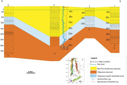
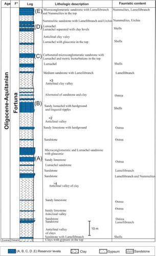
Two detailed lithologic sections of the Oligocene deposits are presented in and . The first section located north of the Cherahil anticline (, position on ), shows 35 m formed of four levels of sandy and bioclastic reservoirs. This series is more developed towards the south of the Cherahil anticline of Kodia El Hamra (position on ), as it shows 136 m composed of five sandy bioclastic bodies separated by clay levels (). This section is situated near hydraulic well 4, and shows that only the upper and sandy part of the Oligocene reservoir is exploited. Two different scales (: 1 cm for 1 m) and (: 1 cm for 5 m) are used to present these sections since reservoir thickness to the south is greater than to the north and we cannot use the same scale to show the detail of both sections.
Figure 4. Lithostratigraphic column of Oligocene Fortuna Formation reservoir levels in the north of Cherahil anticline (position shown on ).
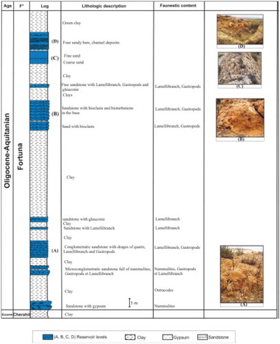
Figure 5. Lithostratigraphic column of Oligocene Fortuna Formation reservoir levels in the south of Cherahil anticline (Kodia Lhamra).
4.2 Reservoir configuration and geometry
Eleven seismic lines (), covering the Sebkhet El Behira–Garaat El Majdoul area, were acquired by petroleum companies during two seismic surveys using different acquisition and processing parameters. The seismic interpretation of two seismic sections (L6 and L7) highlights the different sub-basins within the area ( and ). Both sections are characterized by the presence of a major fault system trending NE–SW and N–S with two deep-seated major faults limiting the Cherahil anticline. The Oligocene reservoir horizons are affected by sealed normal faults proving an extensional phase and reactivated strike-slip compressive faults along the main tectonic corridors of Rheouis and Cherahil anticlines. The first section (L6) trending ENE–WSW (), located south of the study area, crosses in its northeastern part the southern extremity of the Cherahil anticline. In its middle part, the section shows Garâat El Majdoul’s subsiding syncline basin of the sebkhet bounded by two deep reverse faults. It also exhibits the presence of an asymmetrical syncline where the Oligocene and Mio-Plio-Quaternary horizons present a maximum thickness decreasing towards the southeastern and northeastern faulted flanks. In addition, this section outlines Triassic salt bodies intruded along fault networks in Rheouis and Cherahil anticlines (Abbes Citation2004, Ouali Citation2007).
Figure 6. Seismic line (L6) interpretation showing Oligocene and Mio-Plio-Quaternary horizon structure and subsurface to surface faults, subsiding syncline and high anticline basin relationship of Sebkhet El Majdoul (position shown on ).
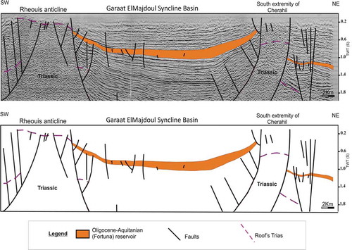
Figure 7. Seismic line (L7) interpretation showing Oligocene and Mio-Plio-Quaternary horizon structuring and subsurface to surface faults, subsiding syncline and high anticline basin relationship of Sebkhet El Majdoul (position shown on ).
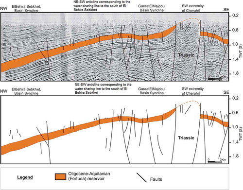
The second section (L7), oriented NW–SE (), shows that the Oligocene and Mio-Plio-Quaternary horizons are more developed in the northwestern part of the seismic line. The thickness variation is controlled by high anticline and subsiding syncline structuring and synsedimentary faults. In the middle of the line, an anticline structure affecting the Oligocene and Mio-Plio-Quaternary horizons is located toward the surface of the plain, which should correspond to the NE–SW limiting axis of the piezometric water sharing line between Sebkhet El Behira and Garaat El Majdoul to the south.
The Oligocene period is characterized in central Tunisia by an extensive phase (Mediterranean phase; Turki et al. Citation1988), which has activated N45 and N160 faults and led to grabens and semi-graben structures (Bédir and Bobier Citation1987, Bédir Citation1988, Citation1990). This structure is responsible for Oligocene thickness variations as shown by Yaïch (Citation1984) and Turki et al. (Citation1988) in the east of Jebel Cherahil.
The structural isochrone map of the top Oligocene horizon () has been realized with respect to the datum plan (DP = 400 m a.s.l.); it highlights the same structures underlined by the seismic lines. Indeed, two major faults can be seen bounding the Cherahil anticline, while the subsurface continuity of the southern extremity of the Cherahil and Elkabbara anticlines does not exceed a depth of 600 m (). The depth map has been generated with respect to the topography (). It shows that the Oligocene reservoir depth does not exceed 500 m () in the high zone to the east and southeast of the basin, reaching 1000 m towards the NW–SE low areas in the centre, and even 1500 m west of the basin.
Figure 8. Isochrone map of the top Oligocene horizon in two-way time in milliseconds (with respect to DP = 400 m a.s.l.).
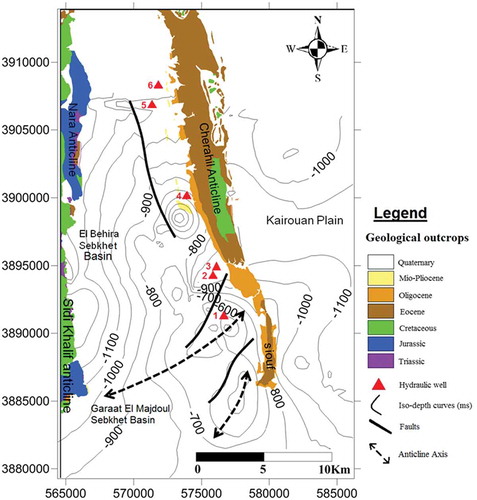
Figure 9. Depth map of the top Oligocene horizon (in m) (with respect to the topography).
The superposition of hydraulic wells with the depth map presents results with the data for hydraulic wells showing small differences due to the seismic calculation ().
Table 2. Comparison of hydrological and seismic data.
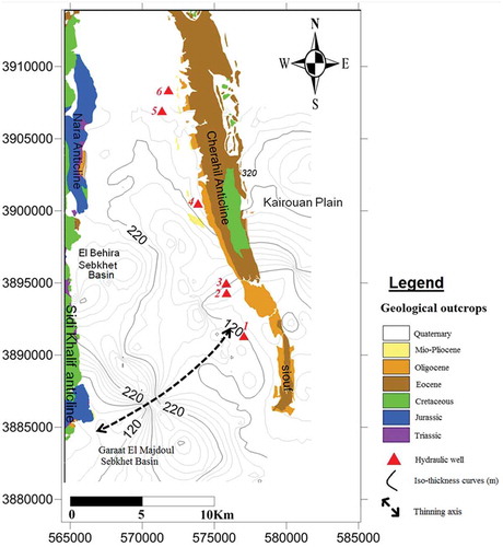
This structuring influences the geometric distribution of the reservoir with a thickness variation from 120 m in the higher levels to 340 m in the subsiding areas (). It exhibits the real thickness in the hydraulic wells: Oligocene thickness is between 120 and 140 m in well 1, with average values between 100 and 120 m in well 2; calculated thickness is 120 m in well 3, 240 m in well 4 and 260 m in wells 5 and 6.
Figure 10. Isopach map of Fortuna Formation (in m).
These results agree with the geological cross-section, taking into account that this reservoir is not well explored and its upper part presents the only exploited aquifer.
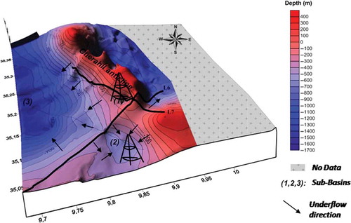
The 3D representation of the top Oligocene horizon shows the presence of three sub-basins (), which could be interesting potential zones.
Figure 11. Three-dimensional representation of top Oligocene reservoir showing the presence of three sub-basins (1, 2 and 3).
4.3 Geological volume estimation
The estimated hydraulic potential of the Oligocene reservoir is based on the following parameters: area (S = 760 km2) represents the surface of the Sebkhet El Behira and Garaat El Majdoul watershed ( and ); reservoir thickness (H = 200 m), an average value adopted from the thickness map; volume (V = S × H = 760 × 106 m2 × 200 m = 152 × 109 m3; and porosity (P = 30 × 10–2). The pore volume is P × V = 30 × 10-2 × 152 × 109 = 45.6 × 10⁹ m3.
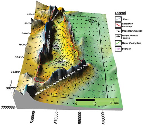
Figure 12. Piezometric map of the Mio-Plio-Quaternary aquifers in Sebkhet El Behira–Garaat El Majdoul showing underflow pathways and highlighted water lines (modified from Mansouri Citation1980).
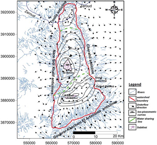
Figure 13. Digital elevation model and piezometric map of the Mio-Plio-Quaternary aquifers in Sebkhet El Behira–Garaat El Majdoul.
The porosity variation is an important parameter to characterize a hydrogeological reservoir. In the Sebkhet El Behira–Garaat El Majdoul basin, the porosity map (Khomsi Citation2005, Khomsi et al. Citation2012) shows that the Oligocene reservoir is marked by high porosity related to fault corridors and extensional tectonics on the crest of collapsed anticlines. In fact, the porosity increases from the southern part (26%), to the PP1 petroleum well (30%) and to the Siouf anticline (37%).
Pore volume = P × V = 30 × 10–2 × 152 × 109 = 45.6 × 10⁹ m3.
4.4 Structural control on the piezometry
Based on the compilation of different data: a piezometric map (Mansouri Citation1980), a digital level model, the hydrographic network and the underground water flow direction, we tried to create a piezometric map of the Mio-Plio-Quaternary aquifer. This exhibits three hydrogeological compartments separated by two water sharing lines, the first situated to the south of the Zeroud River and the second, detected with seismic section (L7: ), isochrone () and isopach maps (), represented by a NE–SW anticline located between El Behira and Garaat El Majdoul Sebkhet.
It clearly shows that the underflow has two general trends: NW–SE and NE–SW, with infiltration from the back-limb of Jebel Cherahil and the fore-limb of Jebel Nara Sidi Khalif anticlines, respectively. Flowing waters ensure the recharge of the Sebkhet El Behira.
To the southern part of the basin, the underground water flow is directed to the Garaat El Majdoul Sebkhet ( and ). Later, part of the flow from Garaat El Majdoul passes through the Ouled Haffouz barrier parallel to the strike fault separating the Goubrar anticline to the south from the northern sub-basins (Mansouri Citation1980), therefore ensuring the supply to the eastern aquifers of the studied zone (Kairouan groundwater).
4.5 Water chemistry
Chemical analysis of major elements of the Oligocene groundwater () highlights NaSO4 chemical facies, with variable salinity values from 0.7 to 1.72 g/L ().
Table 3. Chemical composition of the Oligocene aquifer.
The water quality is controlled by the geographical locations of hydraulic wells exploiting the Oligocene sandstones. In fact, the Ca and Mg concentrations show spatial evolution from the boundary to the natural outlet. This phenomenon is attributed to cation exchange, where the bivalent ions (Mg2+ and Ca2+) tend to replace monovalent ions (Na+) (Appelo and Postmas Citation2005). The same results were also found and discussed in other Tunisian case studies, such as the Kairouan plain, Zeramdine Beni Hassen, Serrat and Cap Bon basin (Ben Ammar Citation2007, Ben Ammar et al. Citation2009, Lachaal et al. Citation2011, Mlayah et al. Citation2011, Citation2013, Chekirbane et al. Citation2013). Indeed, the best water quality is located near Jebel Cherahil, favouring the infiltration of waters loaded with bicarbonates and calcium followed by dissolution of carbonates. The high potassium values could have been caused by artificial fertilizers used in agriculture.
5 Discussion
The 3D representation of the top Oligocene horizon () together with the seismic interpretation shows the presence of two potential areas for exploration of this aquifer. The first is situated in the southeastern part of the Sebkhet El Behira–Garaat Mejdoul basin and is characterized by the abundance of sandy levels, with significant thickness (120 m) and salinity of around 2 g/L, and where the reservoir depth does not exceed 200 m below ground level (b.g.l.). In the second sub-basin, the Oligocene aquifer is deeper (500 m b.g.l.). This area is affected by faults rooted in the Triassic series (Abbes Citation2004, Tanfous Amri Citation2007, Zouaghi Citation2008), which implies the possibility of contamination of deep groundwater by Triassic evaporites. Seismic reflection methods are used in many studies in the Sahel to characterize the relationship between the basin structure and the aquifer distribution and hydrodynamism (Khomsi et al. Citation2012, Lachaal et al. Citation2012, Houatmia et al. Citation2014).
6 Conclusions
In this study we tried to characterize the tectonic basin framework and its relationship to deep aquifers seated in Oligocene subsurface reservoirs in the Sebkhet El Behira–Garaat El Majdoul area (central Tunisia).
We used various data including high-resolution seismic sections, wire line-logging well data, borehole piezometry, structural cross-sections and analysis of outcropping structures. This study was triggered by the increasing agricultural activities and drinking water needs in the area. The structural basin framework established from seismic geophysical maps, isochrone structural depth maps, and iso-thickness maps allowed us to identify the basin structure of the deep fractured Oligocene reservoir horizon as well as the sub-basin reservoir distribution.
In the subsurface, the Oligocene reservoirs are widespread, with great thickness varying between 100 and 320 m, and in many places they are characterized by high porosity and presumably high connectivity, especially along major fault corridors and on the crests of major anticlines. The well logging and field sections outline the occurrence of four to five multilayered fractured sandstone reservoirs for the Oligocene series with some parts having high hydrodynamic and petrophysical characteristics. These series show low salinity (0.7 to 1.72 g/L) in the northern part of the study area and may constitute an important source of drinkable and irrigation water.
Subsurface mapping of the top Oligocene horizon aquifer allows us to identify a NE–SW fractured anticline situated between Sebkhet El Behira and Garaat El Majdoul syncline basins. This high zone corresponds at the surface to the piezometric water sharing line, which separates the two major sub-basins to the northeast and southeast of the sector with the major reservoir thicknesses. The hydrodynamic potential sub-basin is located in the southern extremity of the Cherahil anticline, where the depth of the top Oligocene horizon does not exceed 500 m b.g.l. The second sub-basin is located to the southeast of the sector in Garaat El Majdoul basin, where its depth can reach 800 m b.g.l. ().
The subsurface mapping and seismic interpretations also indicate that the southeastern area of the sector presents the most convenient zone for Oligocene reservoir exploration, suggested by the fact that in this sector the Oligocene reservoir is marked by an abundance of sandstone levels, low salinities and low depths. However, an exploration target is viewed and identified on seismic sections located between El Behira and Garaat El Majdoul corresponding to a subsurface faulted anticline controlling the water sharing underground flows. The reservoirs of this anticline seem to be recharged directly from surface waters through a dense area of sub-cropping fractures.
Chemical analysis of the major elements and the classification of Oligocene groundwater in the western part of the Cherahil anticline exhibit freshwater quality, having a NaSO4 chemical facies that conforms to the national standards of drinkable waters (TN09.14) (Tunisian National standards Citation1982; ), with total dissolved salts lower than 3 g/L.
Acknowledgements
We would like to express our gratitude and thanks to the technicians and engineering staff of Kairouan and Sidi Bouzid water resources regional departments, and also to the researchers and staff members of the georesources and waste water treatment laboratories, for their help and assistance during the field survey and laboratory analysis. Thanks also to the reviewers and co-editor of HSJ for their criticism and fruitful suggestions that highly improved this manuscript. We are grateful to Dr Amina Mabrouk of the Department of Geology, Faculty of Sciences, El Manar Tunis University for her great effort to revise the English text and figure legends of this manuscript.
Disclosure statement
No potential conflict of interest was reported by the authors.
Additional information
Funding
References
- Abbes, C., 1983. Etude structurale du Jebel Touila, extrémité septentrionale du chaînon N-S Sidi Khalif-Nara El Houareb. Thèse Troisième Cycle. Université de Tunis El Manar II, Tunisie, 121 p.
- Abbes, C., 2004. Structurations et évolutions tectono-sédimentaires Mésozoïques et Cénozoïques, associées aux accidents réghmatiques, à la jonction des marges Téthysienne et nord- Africaine (Chaîne Nord-Sud, Tunisie centrale). Thèse ès Sciences. Université Tunis El Manar II, Tunisie, 440 p.
- Appelo, C.A.J. and Postmas, D., 2005. Geochemistry groundwater and pollution. 2nd ed. Boca Raton, FL: CRC Press, 668 p.
- Bédir, M., 1988. Géodynamique des bassins sédimentaires du Sahel de Mahdia (Tunisie orientale) de l’Aptien a l’Actuel. Sismostratigraphie, sismo-tectonique et structurale. Répercussions pétrolières et sismiques. Thèse Troisième Cycle. Université de Tunis El Manar II, Revue des Sciences de la Terre, Tunisie, 9, 242 p.
- Bédir, M., 1990. Ouvertures spatio-temporelles de grabens méso-cénozoïques en méga-fentes de transtension en Tunisie. Comptes Rendus de l’Académie des Sciences, volume 311 ( Paris), Série II, 6 p.
- Bédir, M., 1995. Mécanismes géodynamiques des bassins associés aux couloirs de coulissements de la marge atlasique de la Tunisie, seismo-stratigraphie, sismo-tectonique et implications pétrolières. Thèse ès Sciences. Université de Tunis El Manar II, Tunisie, 412 p.
- Bédir, M. and Bobier, C., 1987. Les grabens de Mahdia et Sidi Chérif (Tunisie orientale). Dynamique (les fossés oligo-miocènes induits au toit d’anticlinaux crétacés - éocènes par les jeux, au Néogène, de décrochement est - ouest et nord – sud. Bulletin de la Société Géologique de France, T III, n°, 6, 1143–1151.
- Bédir, M., et al., 2008. Deep hydrogeologic reservoir investigation by surface and subsurface analyses in eastern Tunisia. 33rd International Geological Congress, 6–14 August, Oslo, Norway.
- Bédir, M., et al., 2005. New geophysic investigations for strategic Neogene deep water geologic reservoirs in eastern coastal sahel area (Tunisia). Sousse, Tunisie: 6 Th Tunisian-Japan Seminar of Culture, Science and Technology, p 74.
- Bédir, M., et al., 2012. Geophysic and geologic deep water reservoir characterisation and evaluation in Eastern Tunisia. American Water Resource Association Conference. 12-15 November, Jacksonville, Florida, USA.
- Ben Ammar, S., 2007. Contribution à l’étude hydrogéologique, géochimique et isotopique des aquifères de Ain el Beidha et du bassin du merguellil (plaine de kairouan): implications pour l’étude de la relation barrage-nappes. Thèse Troisième Cycle. Ecole Nationale d’Ingénieurs de Sfax, Doctorat du Laboratoire de Radio Analyses et Environnement, 226 p.
- Ben Ammar, S., et al., 2009. Evolution de la recharge de la nappe phréatique de la plaine de Kairouan (Tunisie centrale) déduite de l’analyse géochimique. Science et changements planetaires / Sécheresse, 20 (1), 8.
- Bouaziz, S., et al., 2002. Tectonic evolution of the northern African margin in Tunisia from paleostress data and sedimentary record. Tectonophysics, 357, 227–253. doi:10.1016/S0040-1951(02)00370-0
- Boukadi, N., 1994.Structuration de l’Atlas de Tunisie, signification géométrique et cinématique des nœuds et des zones d’interférences. Thèse ès Sciences. Université de Tunis El Manar II, Tunisie, 249 p.
- Burrollet, P.F., 1956. Contribution à l’étude stratigraphique de la Tunisie centrale. Annales de Mines de la Géologie: Tunisie, n. 18, 350 p.
- Chekirbane, A., et al., 2013. Hydrogeochemistry and groundwater salinization in an ephemeral coastal flood plain: Cap Bon, Tunisia. Hydrological Sciences Journal, 58 (5), 1097–1110. doi:10.1080/02626667.2013.800202
- DGRE, 2005. Annuaire de l’exploitation des nappes profondes de l’année 2005. Technical report, DGRE, Tunis, 203 p.
- DGRE, 2008. Annuaire de l’exploitation des nappes profondes de l’année 2008. Technical report, DGRE, Tunis, 210 p.
- Houatmia, F., 2010. Etude géophysique et hydrogéologique du bassin de Sidi Saad. Mém. Master. Université de Tunis El Manar II, Tunisie, 147 p.
- Houatmia, F., et al., 2011. Caractérisation géophysique de l’aquifère Oligocène dans le bassin de Sidi Saâd (Tunisie Centrale). Sousse, Tunisie: Quatrièmes Journées Tunisiennes de Géologie Appliquée, 136 p. p 79.
- Houatmia, F., Khomsi, S., and Bédir, M., 2012. Structuration des bassins associés à l’Axe Nord-Sud et leur implication hydrogéologique: cas des aquifères oligo-néogènes du bassin de Sidi Saâd. Djerba, Tunisie: Ttroisième forum de l’eau, p 35.
- Houatmia, F., et al., 2014. Neogene aquifer: geochemistry and structuring in the Sidi Saad basin, central Tunisia. Arabian Journal of Geosciences, 20 p. doi:10.1007/s12517-014-1433-8
- Khomsi, S., 2005. Géodynamique des bassins paléogènes et des réservoirs associés du sahel de Kairouan (Tunisie orientale); structuration, sismotectonique et organisation séquentielle. Implications pétrolières. Thèse Troisième Cycle. Université de Tunis El Manar II, Tunisie, 365 p.
- Khomsi, S., et al., 2004. Mise en évidence et analyse d’une structure atlasique ennoyée au front de la chaine alpine tunisienne. Comptes Rendu Geoscience, 336, 1293–1300. p547. doi:10.1016/j.crte.2004.05.003
- Khomsi, S., et al., 2006. Mise en évidence en subsurface d’événements compressifs Éocène moyen-supérieur en Tunisie orientale (Sahel): généralité de la phase atlasique en Afrique du Nord. Comptes Rendus Geoscience, 338, 41–49. doi:10.1016/j.crte.2005.11.001
- Khomsi, S., Echihi, O., and Slimani, N., 2012. Structural control on the deep hydrogeological and geothermal aquifers related to the fractured Campanian-Miocene reservoirs of north-eastern Tunisia foreland constrained by subsurface data. Comptes Rendus Geoscience, 344 (3–4), 247–265. doi:10.1016/j.crte.2012.02.002. C. R. Geoscience
- Lachaal, F., et al., 2012. Seismic, gravity, and wire line logging characterization of the Zéramdine fault corridor and its influence in the deep Miocene aquifers distribution (east-central Tunisia). Arabian Journal of Geosciences, 8 p. doi:10.1007/s12517-011-0298-3
- Lachaal, F., et al., 2011. Comprehension and hydrogeological conceptualization of aquifer in arid and semi-arid regions using integrated hydrogeological information system: case of the deep aquifer of Zéramdine-Béni Hassen (east-central Tunisia). Arabian Journal of Geosciences, 19 p. doi:10.1007/s12517-011-0498-x
- Mansouri, R., 1980. Contribution à l’étude hydrogéologique de la plaine de Sebkhet El Behira (Sud Ouest de Kairouan). Thèse Troisième Cycle. Université de Bordeaux, France, 107 p.
- Mlayah, A., et al., 2011. Bassin d’oued Serrat: Terrils et rejets domestiques, reconnaissance des métaux lourds et polluants, impact sur les eaux souterraines (nord-ouest de la Tunisie). Journal of Water Science, 24 (2), 159–175.
- Mlayah, A., et al., 2013. Effet auto-épurateur de la lithologie des affleurements géologiques dans un climat semi-aride: cas du bassin versant de l’oued Mellègue (Nord-Ouest de la Tunisie). Hydrological Sciences Journal, 58 (3), 686–705. doi:10.1080/02626667.2013.772300
- Ouali, J., 2007. Importance du réseau réghmatique dans la tectonogenèse de la Tunisie atlasique à travers l’étude de l’axe Nord-Sud. Thèse ès Sciences. Université Tunis El Manar, Tunisie, 399 p.
- Ouali, J., Tricart, P., and Delteil, J., 1987. Ampleurs et significations des recouvrements anormaux dans l’Axe Nord-Sud (Tunisie centrale), données nouvelles dans le chaînon Nara-Sidi Khalif. Ecolgae Geology, 80 (3), 685–696.
- Rabhi, M., 1999. Contribution à l’étude stratigraphique et analyse de l’évolution géodynamique de l’axe Nord-Sud et des structures avoisinantes (Tunisie centrale). Thèse Troisième Cycle. Université de Tunis El Manar II, Tunisie, 217 p.
- Soussi, M., 2000. Le Jurassique de la Tunisie Atlasique: Stratigraphie, Dynamique sédimentaire, Paléogéographie et Intérêt pétrolier. Thèse Doct. d’état Es Science Géol. Université Tunis El Manar II, Tunisie, 661 p.
- Tanfous Amri, D., 2007. Sismostratigraphie et sismotectonique du Jurassique dans l’Atlas centro-méridional de Tunisie. Thèse Troisième Cycle. Université de Tunis El Manar II, Tunisie, 247 p.
- Truillet, R., Zargouni, F., and Delteil, J., 1981. La tectonique tangentielle dans l’Axe Nord- Sud (Tunisie Centrale). Extrait du compte rendu sommaire de la société géologique de France, n°2.
- Tunisian National standards 1982 for drinking water TN09.14.
- Turki, M.M., et al., 1988. Les inversions tectoniques de la Tunisie centro-septentrionale. Bulletin de la Société Géologique de France, (8) IV (n 3), 7 p.
- Yaich, C., 1992. Dynamique des faciès détritiques oligo-miocènes de Tunisie. Journal of African Earth Sciences (and the Middle East), 15 (1), 35–47. doi:10.1016/0899-5362(92)90004-V
- Yaïch, C., 1984. Etude géologique des chaînons du Chérahil et du Khechem El Artsouma (Tunisie centrale), liaison avec les structures profondes des plaines adjacentes. Thèse Troisième Cycle. Université Besançon, France, 165 p.
- Yaïch, C., 1997. Dynamique sédimentaire, Eustatisme et Tectonique durant l’Oligo-Miocène en Tunisie. Formations Fortuna, Messiouta et Grijima; Numédien et Gréso-Micacé. Thèse Doctorat d’état Es Science Géol. Université Tunis El Manar II, Tunisie, 479 p.
- Yaich, C., et al., 2000. Corrélation stratigraphique entre les unités oligo-miocènes de Tunisie centrale et le Numidien. Compte Rendu. Académie des Sciences. Paris, Sciences de la Terre et des planetes, 331, 499–506.
- Zagrarni, M.F., 1999. Notice de la carte géologique de la Tunisie à 1/50000 de Djebel Khechem feuille n°87. Tunis: Office National des Mines, 16 p.
- Zouaghi, T., 2008. Distribution des séquences de dépôt du Crétacé (aptien-maastrichtien) en subsurface: rôle de déformation tectonique, l’halocinèse et évolution géodynamique (Atlas Central de Tunisie). Thèse Troisième Cycle, Université de Tunis El Manar II, Tunisie. 367 p.