
ABSTRACT
Somalia has frequently been affected by droughts, famines and water-related humanitarian crises. Water is scarce and the only perennial streams, the Juba and Shabelle rivers, are trans-boundary with river flows mainly originating from the Ethiopian highlands. In both riparian countries water demands are projected to increase. This paper reveals the impact of rising regional water abstractions on stream flows by illustrating sectoral demands and joining them into scenarios of medium and high population and economic growth. These scenarios are associated to the time horizons of 2035 and 2055, respectively. The scenarios disclose alarming trends especially for the Shabelle River: in the medium and high growth scenarios, water demands surpass the available river flows by 200 and 3500 hm3, respectively. The calculated deficits partly derive from conflicting assumptions about river flows by the two main riparian countries, an obstacle to any integrated planning efforts and sustained regional development.
EDITOR Z.W. Kundzewicz; ASSOCIATE EDITOR F. Hattermann
1 Introduction
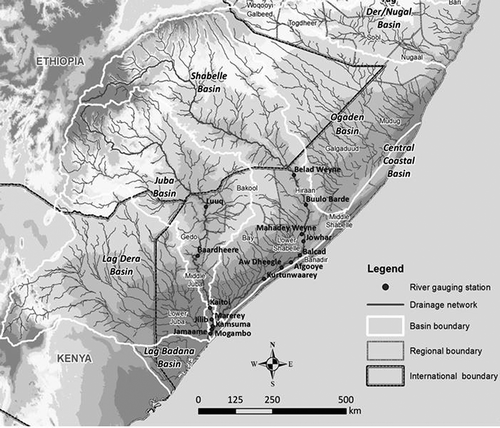
The Horn of Africa is repeatedly struck by droughts and famines with Somalia being particularly affected due to highly variable rainfall, infrastructural breakdowns and the collapse of the national administration as a consequence of civil war (Gadain and Mugo Citation2009). The Juba and Shabelle Rivers are the only perennial streams in Somalia and constitute the basis for the country’s most productive agricultural zone (Basnyat Citation2007). Both rivers are trans-boundary, originating in Ethiopia, while the Juba River possesses an additional seasonal tributary from the Kenyan catchment Lag Dera (Artan et al. Citation2007, Basnyat Citation2007), as illustrated in . It is estimated that more than 90 percent of the runoff for the Juba and Shabelle Rivers is generated in Ethiopia (Kammer Citation1989, Artan et al. Citation2007, Basnyat Citation2007, Mutua and Balint Citation2009). Despite Somalia’s vulnerable downstream position, there are no bilateral treaties (Salman Citation2011) nor any national or sub-national arrangements for a strategic or integrated use of the Juba and Shabelle Rivers on the Somali side. However, Somalia and Ethiopia are parties to the African Convention of Nature and Natural Resources (OAU Citation1968) demanding mutual consultation, coordinated planning and joint development as well as a joint conservation of any resources shared (Salman Citation2011). Elmi (Citation2013) provides a political analysis of the trans-boundary aspects in the basins.
Figure 1. Map of the Juba and Shabelle river basins (spelling of locations may deviate from the text).
Assessing the condition of and the prospects for the regional water resource base is crucial to reveal the concrete urgency of respective integrated and trans-boundary planning. The Juba and Shabelle Rivers are the main elements of the water resource base in south Somalia and assessing their water availability in time constitutes a fundamental piece of research for planning purposes in the basins. The current situation as well as a medium and a high growth scenario reveal the impacts of projected developments, factoring in socio-economic trends and planned upstream abstractions as announced by the Ethiopian Ministry of Water Resources (Citation2004a, Citation2004b, Citation2005a, Citation2005b, Citation2006, Citation2007). The aim of this paper is to enable a comprehensive understanding of water availability in south Somalia. This is achieved by juxtaposing and combining the different water demands in the basins and relating them to the Juba and Shabelle Rivers as the main elements of regional water supply. Hence, this paper provides an overview of the water resources and the climatic context of the basin, followed by the different sectoral demands in Somalia as well as current and planned future abstraction from the tributaries on the Ethiopian side. The discussion combines facts on water availability with projected changes in sectoral water demands, revealing leeway and shortages according to seasons and scenarios.
2 Methodology
To determine and project current and future water demands for the Juba and Shabelle basins, existing literature and data sets were reviewed and analysed.
The Somalia Water and Land Information Management (SWALIM) project reports of the Food and Agricultural Organization of the United Nations (FAO) constituted the basis of information. The most recent SWALIM report (W-22) on water demands for the Juba and Shabelle Rivers (Petersen and Gadain Citation2013) formed a central reference for this paper, since the Juba and Shabelle basins have not been studied before from a trans-boundary perspective and the findings constitute new information on the nature and trends in regional water resource use. This paper emphasizes and complements the hydrological aspects of the SWALIM report W-22 and amends the underlying calculations, e.g. water availability and demands in the Juba and Shabelle basins were not grouped, since they constitute distinct hydrological systems and water abstractions are specific to one or the other basin. Furthermore, in this paper, environmental reserve flows are recognized to underlie seasonal variations and seasonal downstream losses were considered in the water balance. Other SWALIM reports provided detailed information on river flows as gauged in south Somalia (Basnyat Citation2007, Basnyat and Gadain Citation2009) and on groundwater resources (Muthusi et al. Citation2007). Information on groundwater use was importantly complemented by a publication of Faillace and Faillace (Citation1986) which still provides the most extensive account of potential groundwater occurrences in south Somalia. Concerning information on the current extent of irrigated agriculture, conflicting statements in literature were encountered. Their methodologies and the point of reference for this article shall be elaborated and justified at this point while the actual figures are presented in the review and analysis section. Mbara et al. (Citation2007) used inception reports about local irrigation schemes, but did not consider their actual operational status. Monaci et al. (Citation2007) performed an on-screen photointerpretation of satellite imagery, partially validating their evaluation through field visits. However the work of Monaci et al. (Citation2007) does not reveal whether the identified irrigation schemes are or ever were under simultaneous operation. A study by Oduori et al. (Citation2012) determined those areas in the catchment that have been cultivated at least once during the last 4 years. They used remote sensing Landsat, DMC and ASTER images and captured rainfed as well as irrigated areas. Basnyat (Citation2007) presented an analysis accounting for factors like the current status of irrigation schemes and seasonal river flows as well as crop water requirements. The figures of Basnyat seem comparatively low, but his study is the most comprehensive and the results are compatible with the calculations of Mbara et al. (Citation2007), as well as with the GIS results of Monaci et al. (Citation2007). The study by Basnyat (Citation2007) seems conceptually most sound and suitable to the focus of the paper at hand, hence the data on irrigation water requirements, cultivated as well as cultivable areas of Basnyat (Citation2007) served as a basis for the different scenarios.
Information on upstream developments and their impacts on stream flows is based on the master plans for water resources development issued by the Ethiopian Ministry of Water Resources (Citation2004a, Citation2004b, Citation2005a, Citation2005b, Citation2006, Citation2007). The consideration of climate change and its impacts on water availability in the basin were beyond the scope of this paper. There were no data available on industrial water use or effluent qualities and quantities discharged into the rivers. Furthermore, data did not suffice to provide holistic calculations of environmental flow requirements (EFRs) for the two rivers required to sustain local ecosystems and livelihoods (Muthusi et al. Citation2007, Sebhat Citation2013). An estimate for environmental reserve flows was used to represent the stake of the environment in the basins. The estimate was based on regional EFRs and global information on variable stream flows (Pastor et al. Citation2013).
The robustness of the underlying methodology, the topicality and verification of the data through extensive comparisons of sources were decisive criteria for the selection of data inputs for this research.
3 Review and analysis
3.1 Water availability in the context of the Somali Juba and Shabelle basins
The Juba and Shabelle basins cover 17 4000 km2 within Somalia, while over 60% of the total catchment area are located upstream in Ethiopia (Basnyat and Gadain Citation2009). Most of the runoff is generated in the Ethiopian highlands (Ministry of Juba Valley Development Citation1990, Muthusi et al. Citation2009). The Juba and Shabelle are the main supply of water resources for the riverine population in south Somalia, constituting the basis for irrigated agriculture as well as the regional groundwater recharge.
The mean annual river flows of the Juba and Shabelle as gauged on the Somali side have been quantified as 5900 hm3 and 2400 hm3 respectively (Basnyat and Gadain Citation2009). The inter-annual fluctuations are significant: The flow of the Juba River at Luuq fluctuated between 3150 and 10 700 hm3 per year with a standard deviation of 1.8 between those years where daily flow volumes were available for 95% of the days in a year (0.95% complete flow records based on data by SWALIM Citation2012). The flow of River Shabelle at Beled Weyne fluctuated between 1580 and 4730 hm3 per year, with a standard deviation of 0.96 in 27 years of highly complete (0.95) hydrological records. Both gauging stations are located in close proximity to the Ethiopian border. The river flows have been gauged and recorded since 1964 and records are available except for the war period between 1991 and 2002 (Houghton-Carr et al. Citation2011, SWALM Citation2012). Also the intra-annual and hence seasonal variations are substantial, as depicted in for the Juba and in for the Shabelle River.
Figure 2. Long-term average (1970–1989) flows along the Juba River (hm3 per month).
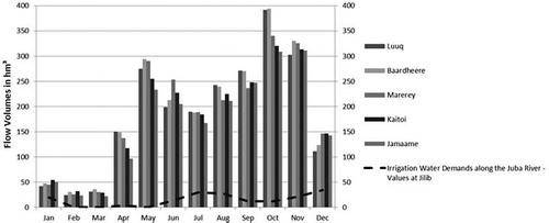
Figure 3. Long-term average (1970–1989) flows along the Shabelle River (hm3 per month).
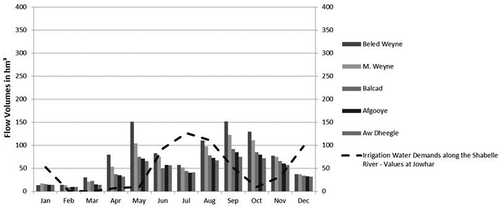
and furthermore illustrate that along the river courses the flow volumes reduce, mainly due to low downstream contributions to the stream flow and abstractions for irrigation but also due to spillage, evaporation and infiltration recharging groundwater aquifers (Artan et al. Citation2007, Basnyat and Gadain 2009, Muthusi et al. Citation2009, Thiemig et al. Citation2010). Comparing gauged values of upstream and downstream stations, the flow reductions along the Shabelle River are more pronounced than for the Juba River, indicating a more intensive use of its waters (Basnyat Citation2007, Thiemig et al. 2010, Muthusi et al. Citation2009). For both rivers, water “losses” along the course are highest during peak flow seasons, partly because water demands are higher and partly due to greater spillage events. The average flow reduction based on the comparison of monthly flows of the first (upstream) and the last (downstream) station, amounts to 7% for the Juba and 35% for the Shabelle River; 50% and 72% of these losses are active abstractions from the river to satisfy agricultural, domestic and livestock needs leaving 207 hm3 (3.5%) and 239 hm3 per year (10%) of upstream river flows that percolate to the groundwater or evaporate. The share that percolates to the groundwater is not lost from the system but available for abstraction in the basin (with a time lag). Evaporation in south Somalia has been measured at a number of meteorological stations along the rivers (Muchiri Citation2007). Based on river cross-sections as well as climatic conditions (Basnyat and Gadain Citation2009) the ratio of evaporation losses to percolation is estimated at 1:1. This estimate results into 103 hm3 (1.75% of total) of evaporation losses along the Juba River and 119 hm3 (5%) along the Shabelle River. Evaporation losses mainly occur during the months of the dry season and are therefore attributed to these.
While during the dry season downstream river flows may be reduced to almost zero, floods are a frequent problem during the wet season, particularly along the Juba River, threatening fields and residences established in close proximity to the streams (IUCN Citation2003, Basnyat Citation2007, Muthusi et al. Citation2007). Floods are however also used for recession cultivation in so-called desheks, natural depressions in riverbanks after the flood water recedes (Oduori et al. Citation2007).
Concerning the water quality of the Juba and Shabelle Rivers, it is described as highly saline and as humans and livestock are in direct contact with it for consumption and basic hygiene, it deteriorates along the river course (Basnyat Citation2007). Concerning groundwater abstractions, no data currently exists on how much of the water demands in the basins are satisfied from this resource instead of direct abstractions from the rivers. The groundwater aquifers however mainly depend on inflows from the Juba or Shabelle Rivers (Basnyat Citation2007) and hence their continuance is directly linked to the river flows. Besides ground and surface water resources, rainwater harvesting has been reported to be an important alternative resource in some locations in the basin during the wet season (Muchiri Citation2007). The dimension of rainwater use is however unknown, but given average rainfall amounts of 425–500 mm per year and high evaporation rates in the two basins, rainwater seems to be a negligible resource compared to groundwater and river abstractions.
3.2 Upstream developments (Ethiopia)
While Somalia is the major water user in the basin with a longer history of irrigated agriculture, Ethiopia dominates the river basin in terms of geographic position and population numbers as well as economic and institutional power to advance development projects. In addition to already existing upstream river infrastructure and abstractions, the Ministry of Water Resources in Ethiopia envisions the implementation of major dam and irrigation projects along their parts of the Juba and Shabelle Rivers (Citation2004a, Citation2004b, Citation2005a, Citation2005b, Citation2006, Citation2007). The implementation of these would heavily regulate the river flows downstream, as illustrated in and . The indications of flow reductions in and are based on the official statements in the indicated master plans of the Ethiopian government. The numbers seem underestimated, e.g. a doubling in irrigated area until 2022 in the Ethiopian Juba and Shabelle basins is projected to result merely in a 1–2% additional flow reduction. However, 1% of Shabelle flows correspond to 100 hm3 per year (2000 m3 per hectare per year for the newly irrigated areas in Ethiopia) and 2% of the Juba River flows correspond to about 70 hm3 of water (4100 m3 per hectare per year). Given the higher rainfall amounts in the Ethiopian parts of the basin and considering local cropping patterns, this figure is plausible and therefore has been employed for this study. The Shabelle River would be particularly affected by the Ethiopian development plans, facing the greatest abstractions in absolute as well as in relative terms.
Table 1. Ethiopian development plans for the Juba River.
Table 2. Ethiopian development plans for the Shabelle River (based on MoWR Citation2005b).
It is important to note that there exists a discrepancy between Ethiopian reports and Somali measurements concerning stream flows crossing the border into Somalia. The Ethiopian master plans (MoWR Citation2005b, Citation2007) refer to average river flows of 6750 hm3 for the Juba River and 3900 hm3 for the Shabelle River, while the gauging on the Somali side indicate lower numbers: 5900 hm3 for the Juba River and 2400 hm3 for the Shabelle River (Basnyat and Gadain Citation2009, based on the gauging stations at Luuq and Beled Weyne). The master plan implementation on the Ethiopian side is currently delayed but their water use for agriculture, domestic and livestock use is projected to increase sooner or later to meet the population’s basic demands for water and food.
For the research at hand, it is assumed, that the planned abstractions on the Ethiopian side have been correctly indicated by the Ethiopian Ministry of Water and Resources in terms of the amounts envisioned but these are expected to materialize on divergent time horizons: The 2022-level envisioned for the Juba River (270 hm3 annual abstractions) and 2010-level envisioned for the Shabelle River (1300 hm3 annually) are assumed to be reached in 2035. These assumptions are incorporated into the medium growth scenario. For the high growth scenario, it is assumed that the envisioned full development scenarios for the Juba and Shabelle Rivers are reached in 2055. Concerning river flows, this paper assumes that the Somali gauging stations yield the most reliable numbers on stream flows entering the country since the Ethiopian master plans do not provide any reference nor do they name the corresponding gauging station for their figures.
3.3 Domestic water demands in south Somalia
The UNDP (Citation2005) has estimated the population of south Somalia as being 2 792 965 (62%) in rural areas and 1 687 815 (38%) in urban areas, including the regions of Hiraan, Middle Shabelle, Banadir, Lower Shabelle, Bay, Bakool, Gedo, Middle Juba and Lower Juba. In line with the Human Development Report of 2006, Basnyat (Citation2007) assumed water demands of 20 litre per capita per day (L/c/d) and 50 L/c/d for the rural and urban population, respectively. On this basis, a total domestic water demand of 140 250 m3/d was determined, translating into 51.2 hm3/year. Under these assumptions, despite a population share of 38%, the urban population consumes 60% of the domestic water used. Furthermore, there is an apparent trend in urbanization: The population that migrated from rural to urban areas between 1988 and 2005 is 15%, corresponding to an annual increase of 0.88% in linear terms (Ministry of National Planning Citation1988, UNDP Citation2005). It was not possible to derive an exponential growth function from the two point estimates from 1988 and 2005. Extrapolating the growth trends into the future, population numbers and associated domestic water demands are shown in .
Table 3. Population numbers and associated domestic water demands in Somalia.
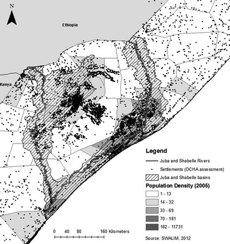
Due to the high political instability in the region, migration and development constraints, the projected numbers are subject to unpredictable fluctuations and bear considerable uncertainties. No figures are available on how many people are associated to the Juba and the Shabelle basins, respectively, but due to the higher population density along the Shabelle (see ), 60% of the population are attributed to the Shabelle basin and 40% to the Juba basin for the purpose of this study.
Figure 4. Map of settlements and population densities in south Somalia.
3.4 Agricultural water demands in south Somalia
Ninety percent of the Somali crop production takes place in the alluvial plains of the lower Juba and middle Shabelle basins as well as in the inter-riverine area of the Bay region (Basnyat Citation2007). The extent of irrigated areas, current as well as projected based on specified development scenarios, is illustrated in .
Table 4. Various scenarios for agricultural growth: areal and irrigation requirements.
The main crops in the basin are maize and sorghum while rice, cereals, bananas, vegetables and fruit trees are common as well (Basnyat Citation2007). Based on typical cropping patterns in the two basins, Basnyat (Citation2007) determined average irrigation water demands of 11 000 m3/hectare. Seasonal fluctuations in current abstractions for agriculture are displayed in and . In total, agriculture in the two basins is estimated to currently consume 715 hm3 of river water. Despite the lower flow volume of the Shabelle River, greater amounts are abstracted (550 hm3). This is due to the existent extent of infrastructure and use of gravity irrigation as well as favourable soil properties that facilitate agricultural utilization (Basnyat Citation2007). Under a medium growth scenario, agricultural demands are projected to increase to 1155 hm3 in the two basins: 275 hm3 along the Juba River and 880 hm3 along the Shabelle River. The FAO/European Commission (Citation2004) provided a combined estimate for both the Juba and the Shabelle basins, indicating a maximum extension of agricultural areas to about 265 000 ha, corresponding to about 2915 hm3 of irrigation water needs.
3.5 Livestock water demand in south Somalia
Livestock is the backbone of the Somali economy as well as an important source of nutrition and income (IUCN Citation2003). In 1990 about 55% of the Somali population was directly engaged in livestock production (FAO/WB/EU Citation2004). In the Juba and Shabelle basins, grazing of goats, sheep, cattle and camels is among the dominant land use types (Oduori et al. Citation2007). The only available data on livestock numbers in the basins stems from a pre-war record from 1988, based on data by the Ministry of Agriculture as quoted by Basnyat (Citation2007) (see ).
Table 5. Livestock numbers and water demands in southern central Somalia, 1988.
If water demands of 1.6, 12 and 25 litres per day (L/d) are assumed per sheep/goat, camel and cattle, respectively, then a total daily water livestock requirement of 114 000 m3 for the basin can be determined (Basnyat Citation2007). This translates into a demand of 41.6 hm3/year if livestock numbers remain constant. However, the FSNAU (Citation2012) observed a trend of increased livestock keeping and likely the growing population also needs a higher supply with livestock related products. Also, there is a high fluctuation in livestock numbers in the single areas due to pastoral movements across the region in search for grazing grounds and water (Houghton-Carr et al. Citation2011, FSNAU Citation2012). For as long as there is no up-to-date panel data for the basin, estimates and projections on livestock numbers have to be based on the last comprehensive data set issued by the MoA in 1988, as described in Basnyat (Citation2007) based on 1988 data from the Ministry of Agriculture (MoA).
3.6 Environmental water demands
In order to maintain ecological services as well as the natural channel habitat associated to the historic flow regimes of the Juba and Shabelle Rivers, certain reserve flows have to be maintained and must be considered as sectoral demands on their own (Muthusi et al. Citation2007). The minimal flow requirements may vary seasonally and along the peculiarities of the different river subsections as well as ecosystems (Pastor et al. Citation2013). In order to perform an Environmental Flow Assessment (EFA) at a local or basin scale, information on the aquatic and riparian ecology, water quality, hydraulics, hydrology and geomorphology is required (Poff et al. Citation2009). For the Juba and Shabelle Rivers, this information however is currently unavailable. EFAs from East Africa were used to reveal the approximate dimension of environmental flow requirements and to reserve a fixed share of the monthly flows assumed to cover minimal environmental needs in the Juba and Shabelle basins. An EFA performed for the Mara River between Kenya and Tanzania determined annual average reserve flows of 25–35% (LVBC Citation2010). For the Great Ruaha River, environmental flow requirements of about 10% were determined (McClain et al. Citation2013). For the Juba and Shabelle Rivers, a conservative estimate for minimal environmental flows shall be set, namely 10% of current monthly averages, corresponding to low environmental management classes and hence a rather strong and unregulated human influence on the rivers (Smakhtin and Anputhas Citation2006). This percentage translates into annual environmental demands of 590 hm3 for the Juba River and 240 hm3 for the Shabelle River. For the dry season, Jilaal (December to March), 10% of the historic seasonal flow averages based on Basnyat (Citation2007) were assumed, namely 68.8 hm3 for the Juba River and 23.5 hm3 for the Shabelle River. Compromising the environmental flows would imply that development in the basin happens at the expense of environmental services, traditional livelihoods and, hence, the life quality of current and future generations in the basin.
4 Results and discussion
For the purpose of this analysis, the river flows were set in direct relation with the sectoral demands in the basin. Due to a lack of information on flow regimes and abstractions in space and time, the systemic set-up had to be simplified by assuming a static river flow for the two streams and by subtracting the aggregated demands from this quantity. Since groundwater recharge is taking place through percolation from the river beds as well as the associated flood plains, percolation losses were not accounted for and groundwater abstractions are not distinguished from the demands for river water. As mentioned in the section on water availability, there are considerable inter-annual fluctuations in river flows, hence the actual annual flow availability may lie about 35% above or below the determined average flows. These percentages are based on the standard deviations of 0.93 for Shabelle stream flows at Beled Weyne and 1.8 for Juba stream flows at Luuq. In current high flow years we can thus assume total flow volumes of 3300 hm3 for the Shabelle and 7700 hm3 for the Juba River, while in low flow years we can use estimates of 1500 hm3 and 4100 hm3. In this section, high flow volumes are only referred to when abstractions under a certain development scenario result in extremely low river flows. By comparing the abstractions to an above average water availability, persistent signs of scarcity gain significance and may consolidate trends.
4.1 Current river flows and abstractions
Current river flows of 5900 hm3 per year for the Juba River and 2400 hm3 annually for the Shabelle River were used, referring to the average values of time series measured at Luuq and Beled Weyne, both located close to the Ethiopian border (Basnyat and Gadain Citation2009). Assuming evaporation losses of 1.75% and 5% for the Juba and Shabelle basins, respectively, the available amounts decrease to 5800 hm3 and 2281 hm3 per year.
Agricultural water demands amount to 165 hm3 annually for the Juba River (Mbara et al. Citation2007, Monaci et al. Citation2007) and to 550 hm3 per year for the Shabelle River (Basnyat Citation2007).
Of the domestic water needs, 60% of the basin total are assigned to the Shabelle River while 40% are attributed to the Juba River, translating into 30.7 hm3 and 20.5 hm3 of domestic water demand. The underlying population numbers refer to 2005 levels, the year of the last census.
Livestock demands could not be differentiated for the single basins and hence an equal amount of 20.8 hm3 is assigned to the Juba and Shabelle basins.
The environmental reserve flows are estimated as 10% of the total stream flows, relating to historic flow averages and hence amounting to about 590 hm3 for the Juba River and 240 hm3 for the Shabelle River.
The “remaining river flows” are the stream flows after the deduction of all associated demands as mentioned above.
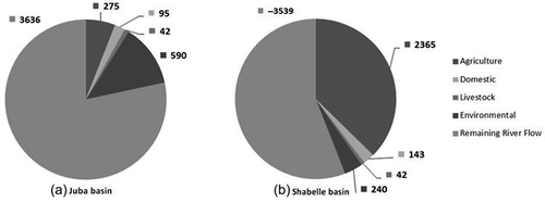
) and () set the current demands and available flows into proportion.
Figure 5. Current annual sectoral water demands (hm3) in: (a) the Somali Juba basin (796 hm3; 14% of available flow), and (b) the Somali Shabelle basin (842 hm3; 37% of available flow). Categories arranged clockwise.
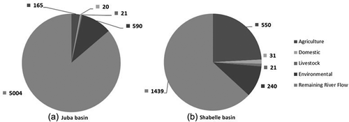
The comparison of annual river flows with annual sectoral water demands reveals that a higher proportion of the Shabelle River water (37%) is used as compared to the Juba River water (14%). While the environmental demand (10% of total flow) makes up the greatest share in the Juba basin, agriculture (23% of total flow) is the greatest water consumer along the Shabelle. Even in low flow years, the two rivers can satisfy the prevailing demands.
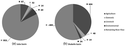
To provide a snapshot of water availability in the dry season, Jilaal, mean monthly flow values for the associated months, namely December, January, February and March as given by Basnyat (Citation2007), were aggregated and compared with the sectoral abstractions: The crop water demands for the Jilaal months were also given by Basnyat (Citation2007) while the seasonal domestic and livestock demands were taken as a third of the annual levels. Monthly variations in the latter are certain, but could not be determined based on the data available. The environmental flow requirements were taken as 10% of the historic seasonal flow averages, namely 68.8 hm3 for the Juba River and 23.5 hm3 for the Shabelle River. It must be considered that evaporation losses mainly occur during the dry season and hence associated losses from the rivers are entirely attributed to the Jilaal months. The evaporation losses of 103 hm3 and 119 hm3 are therefore abstracted from the seasonal flows, resulting in 585 hm3 for the Juba and 116 hm3 for the Shabelle River. ) and () illustrate current river flows versus demands in the Jilaal season.
Figure 6. Current dry season sectoral water demands in: (a) the Somali Juba basin (137 hm3; 23% of available flow); and (b) the Somali Shabelle basin (192 hm3; 166% of available flow). Categories arranged clockwise.
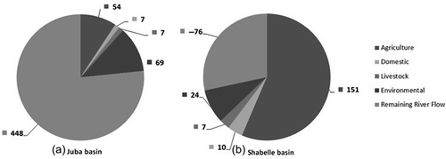
) and () reveal that during the dry season, demands in the Juba basin make up 23% of the stream flow while demands in the Shabelle basin surpass the supplies by 66%. While the Juba basin evinces considerable leeway for further abstractions even during the dry season, there is a gap in supply and demand in the Shabelle basin, even if the environmental reserve flow of 24 hm3 was entirely used.
4.2 Medium growth scenario (2035)
Recognising socio-economic development trends in Somalia as well as planned upstream developments, a scenario based on medium growth assumptions was drafted. The following assumptions were made:
The agricultural production in Somalia increased by means of rehabilitation concerning the irrigation infrastructure along the Juba (annually 275 hm3) and maximal river water use (without additional flow regulating infrastructure) along the Shabelle (annually 880 hm3).
The population in the Somali part of the basin has grown from 5.5 million in the baseline situation to almost 10 million (in 2035). It had doubled after 27 years: 52 hm3 and 78 hm3 are required to satisfy domestic water demands in the Juba and the Shabelle basins, respectively.
Livestock numbers in Somalia have doubled too, heavily straining the environment, leading to overgrazing and erosion as well as the accelerated depletion of seasonal ponds and reservoirs with the consequence of a heavier reliance on river water: 41.6 hm3 per basin per year.
Environmental flow demands remained constant and relate to original levels of the river: 590 hm3 annually for the Juba River and 240 hm3 for the Shabelle River.
On the supply side, a medium upstream development in Ethiopia took place using the 2010 assumptions by the Ministry of Water Resources (MoWR) for the Shabelle River (1300 hm3 annual abstractions, leaving 1100 hm3 crossing the border according to Somali figures) and the 2022 scenario for the Juba River (760 hm3, leaving 5140 hm3 crossing the border based on Somali figures). Considering evaporation losses of 1.75% along the Juba and 5% along the Shabelle River, available flow volumes reduce to 5050 hm3 and 1045 hm3 respectively.
) and () sets the sectoral demands and available flows under medium growth assumption into proportion.
Figure 7. Annual sectoral water demands under medium growth assumptions: (a) Somali Juba basin (959 hm3; 19% of available flow); and (b) Somali Shabelle basin (1240 hm3; 119% of available flow). Categories arranged clockwise.
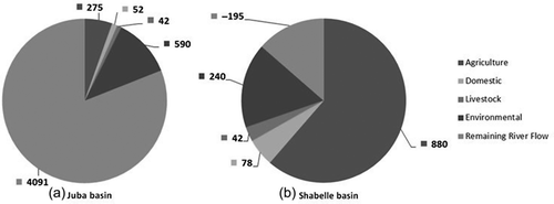
) and () reveals different conditions for the two rivers: While in the Juba basin demands make up 19% of the available flows, demands in the Shabelle basin make up about 119% of total river flows. The demands in the Shabelle basin under medium growth assumptions are beyond the available supply and if agricultural, livestock and domestic demands were maintained, the missing shares are likely to be covered by using the environmental reserves. If the gap was filled by tapping environmental reserve flows, these would reduce to 1.9% instead of the envisioned 10% of average historic flows. If we assume a fluctuation of 35% above predicted average flow rate, in a high flow year (with 1411 hm3) all demands could be satisfied. During a low flow year (with 680 hm3) only about half of the demands in the basin could be covered.
Concerning the dry season flows and demands under medium growth assumptions: Monthly projections for river flow rates were indicated in the Ethiopian master plans (MoWR Citation2005b, Citation2007). The share of flows associated to the Jilaal season could be transferred to the Somali figures on stream flows (Basnyat Citation2007, Basnyat and Gadain Citation2009). The MoWR (Citation2007) indicated the stream flow for the Juba River on the Ethiopian side as 5878 hm3, while 1223 hm3 are projected to occur during the Jilaal season. This corresponds to a share of 20.8% which is multiplied with the annual stream flow in Somalia under medium growth assumptions (5900–760 hm3 upstream abstractions) to yield seasonal stream flows of the Juba River on Somali territory, namely 1069 hm3 during the four Jilaal months December, January, February and March. For the Juba River a certain degree of flow regulation can be observed under this scenario due to infrastructural projects such as the Hydroelectric Power Plant GD3. Hence the projected dry season flows in the Juba River are relatively high. Along the river, on the Somali side, evaporation losses of about 1.75% (of annual amounts) must be considered, resulting in 980 hm3 of available stream flow during the dry season.
For the Shabelle River, the share of flows during the Jilaal months compared to the total stream flows on the Ethiopian side corresponds to 26.4% (MoWR Citation2005b). This share is multiplied with annual stream flow in Somalia under medium growth assumptions (2400–1300 hm3 upstream abstractions) to yield the seasonal stream flows of the Shabelle River on Somali territory, namely 290.2 hm3 during the four Jilaal months. Evaporation losses of 5% must be considered, resulting in available stream flows of 235 hm3 for the Shabelle River.
Concerning agricultural demands, the figures of Basnyat (Citation2007) were used to determine the seasonal shares of crop water requirements. It was assumed that the current seasonality of agricultural demands is maintained and hence the seasonal shares of future agricultural water demands could be determined: For the Shabelle basin, the current Jilaal irrigation water needs amount to 151 hm3 compared to a current total of 591.5 hm3, yielding a ratio of 25.5%. Applied to the projected agricultural water needs under medium growth assumptions (880 hm3), seasonal demands in the Shabelle basin are determined as 225 hm3. In the Juba basin, the ratio is 31.5% (54 hm3/171.42 hm3), yielding irrigation requirements of about 86.6 hm3 for the Jilaal season (275 hm3*0.315).
The seasonal domestic and livestock demands were taken as, respectively, one third of the annual levels. The environmental flow requirements were taken as 10% of the historic seasonal flow averages, namely 68.8 hm3 for the Juba River and 23.5 hm3 for the Shabelle River. The results of these calculations are presented in ) and ().
Figure 8. Dry season sectoral water demands under medium growth assumptions: (a) Somali Juba basin (186 hm3; 19% of available flow); and (b) Somali Shabelle basin (288 hm3; 123% of available flow). Categories arranged clockwise.
In the Somali Juba basin under medium growth assumptions, the different sectoral demands make up about 19% of the seasonal river flows. The Somali water demands in the Shabelle basin make up 123% of the total flows. The seasonal gap is more severe than the annual one since all evaporation losses are assumed to take place during the dry season. The discrepancy to the annual balance is, however, not large since the highest irrigation needs occur during the wet season during the months of June, July and August when river flows are higher (Basnyat Citation2007). On the annual balance as well as during the dry season, water demands in the Shabelle basin are higher than the available supplies. The gap in the water balance is alarming and demonstrates the limits of development in the Shabelle basin.
4.3 High growth scenario (2055)
A high growth scenario was drafted with the following assumptions regarding the year 2055:
The agricultural production in Somalia increased, maintaining the irrigation infrastructure along the Juba (resulting in annual demands of 275 hm3) and achieving a maximum river water use (regulated), plus extensions along the Shabelle (2365 hm3 annually) based on estimates of the FAO/EC (Citation2004).
The population in the Somali part of the basin has grown from 5.5 million in the baseline situation to almost 17 million in 2055, implying domestic water needs of 95 hm3 in the Juba basin (40% of total) and 142.5 hm3 in the Shabelle basin (60% of total).
Livestock numbers in Somalia stayed the same compared to the medium growth scenario since environmental limits were presumably reached. The livestock water demands are estimated as 41.6 hm3 per basin per year.
Environmental demands stayed the same relative to the initial river flow: annually 590 hm3 for the Juba River and 240 hm3 for the Shabelle River.
On the supply side an intensive upstream development in Ethiopia took place. The 2035 MoWR assumptions for the Shabelle River (3150 hm3) and the 2037 scenario for the Juba River (1180 hm3) are applied, yielding an annual gap in river flows of 750 hm3 for the Shabelle River and remaining flows of 4720 hm3 for the Juba River entering Somalia. Under these assumptions, for the Shabelle River only in wet months would river flows actually reach Somalia. No evaporation losses for the Shabelle River are assumed in this scenario, but for the Juba River 82.6 hm3 are lost during the dry season due to evaporation, resulting in annual available flows of 4637 hm3.
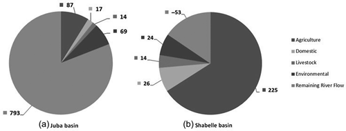
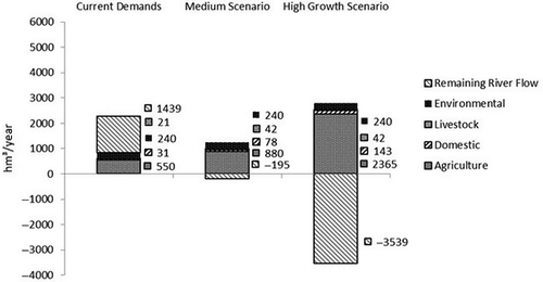
The results are displayed in ) and ().
Figure 9. Annual sectoral water demands under high growth assumptions: (a) Somali Juba basin (1002 hm3; 22% of available flow); and (b) Somali Shabelle basin (2789 hm3; deficit of 3539 hm3). Categories arranged clockwise.
The demands in the Juba basin under the high growth scenario amount to about 22% of the available river flows while in the Shabelle basin, demands are far beyond the limits of supply with a deficit of 3539 hm3/year. The analysis reveals that at full upstream development as planned by Ethiopia, the population in the Somali Shabelle basin would be unable to satisfy even their basic water needs. For the Shabelle basin, it must be noted that even if Ethiopia remained on the current level of abstractions, Somali demands under the high growth scenario would surpass the hydrologic capacities of the basin: Aggregating the agricultural, domestic, livestock and environmental water demands on the Somali side under high growth assumptions results in demands of about 2789 hm3, surpassing the water availability by 508 hm3 per year. Only additional flows of more than 750 hm3, e.g. during high flow years, could reach the Somali basin to potentially satisfy the basic needs of the population.
Concerning the dry season demands and supplies under the high growth scenario: As for the medium growth scenario, flow volumes are determined by transferring the relative monthly stream flows as projected by Ethiopia to the absolute river flows based on Somali measurements. For the Juba basin, flows of 4720 hm3 (5900 hm3 Somali measurements minus 1180 hm3 planned Ethiopian abstractions) are multiplied with 26.2% (flow volume of the Jilaal months/total annual flow volume according to the MoWR, Citation2007). The calculations yield a seasonal flow of about 1236.6 hm3 for the Juba River. Abstracting 1.75% of evaporation losses, the available flows reduce to 1154 hm3 during the dry season. For the Shabelle River, little but mostly no water reaches the Somali side during the dry season. Due to the upstream developments (e.g. the Hydroelectric Power Plants GD3 (Juba) and the WS18 (Shabelle)), flow regulations are achieved for both rivers under the full development scenario. These are however insufficient to maintain flows in the Shabelle basin.
The figures of Basnyat (Citation2007) were used to determine the seasonal agricultural water demands: Like in the medium growth scenario, it was assumed that the current seasonality of agricultural demand was maintained and hence the seasonal shares of future agricultural water demand were determined. Jilaal agricultural demands amount to 25.5% of the annual demands for the Shabelle River and 31.5% for the Juba River, yielding agricultural demands of 603.8 hm3 for the Somali Shabelle basin and 86.6 hm3 for the Somali Juba basin. Identical monthly shares for domestic and livestock demands were assumed. The environmental flow requirements were taken as 10% of the historic seasonal flow averages, namely 68.8 hm3 for the Juba River and 23.5 hm3 for the Shabelle River. The results of these calculations are presented in ) and (). is presented to illustrate the theoretical amounts of Somali demands.
Figure 10. Dry season sectoral water demands under high growth assumptions: (a) Somali Juba basin (201 hm3; 17% of available flow); and (b) Somali Shabelle basin (689 hm3; deficit of 885 hm3 during the Jilaal season). Categories arranged clockwise.
The seasonal water demand differentiation confirms the hydrological deficit in the Shabelle basin within the high growth scenario: The seasonal deficit amounts to 885 hm3. In the Juba basin, seasonal demands make up 17% of the available river flows, leaving room for further water abstractions even under full development on the Ethiopian side.
4.4 Comparison of scenarios
Comparing the three scenarios, for the Juba River an increase in demand of 20% in the medium and 25% in the high scenario as compared to current figures can be observed, while available stream flows reduce by 13% and 20%, respectively, increasing the gap between demand and supply. For the Shabelle River, demand increases by 47% in the medium and 230% in the high growth scenario, while available stream flows reduce by 54% and 131%, respectively. The trends and shares are illustrated in and .
Figure 11. Comparison of scenarios for the Juba River: demands increase by 20% in the medium scenario and by 25% in the high scenario, while river flows to Somalia decrease by 13% and 20%, respectively.
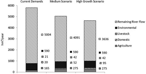
Figure 12. Comparison of scenarios for the Shabelle River: demands increase by 47% in the medium scenario and by 230% in the high scenario, while river flows to Somalia decrease by 54% and 131%, respectively.
5 Conclusion
The scenarios employed in this study are based on a simplified systemic set-up with average monthly flow volumes and conservative estimates for water abstractions. The impacts of the stepwise upstream development scenarios revealed leeway for development in the Juba basin and substantial limitations for further water abstractions in the Shabelle basin. If the hydrological deficit is compensated by accessing environmental reserve flows, key ecosystem functions, as well as groundwater renewal, may be at risk and by that the livelihood of people in the Shabelle basin could be compromised.
At full implementation of the Ethiopian development plans, the upstream abstractions from the Shabelle River (3150 hm3 per year) would surpass the available river flow as gauged on the Somali side (2400 hm3 per year) by 31.3%. The different assumptions on stream flows between Ethiopia and Somalia constitute a fundamental threat to future cooperative efforts between the two riparian states and must be resolved in order to allow transboundary development planning.
A detailed environmental flow assessment is recommended for further studies. Moreover, it must be investigated how far demands are met by alternative water resources, such as groundwater and rainwater, and how the use of these resources is interrelated.
Acknowledgements
The support received from SWALIM staff in providing and analysing the data is highly appreciated. Special thanks go to Dr. Zoltan Balint, former Chief Technical Advisor of SWALIM project, Mr. Flavian Muthusi, hydrologist and Ms. Peris Muchiri, hydrometeorologist.
Disclosure statement
No potential conflict of interest was reported by the authors.
Additional information
Funding
References
- Artan, G., et al., 2007. Improving flood forecasting and early warning in Somalia – Feasibility study ( Project Publication No W-10). Nairobi, Kenya: FAO SWALIM (GCP/SOM/EC045).
- Basnyat, D.B., 2007. Water Resources of Somalia ( Technical Report No W-11). Nairobi, Kenya: FAO SWALIM (GCP/SOM/045/EC).
- Basnyat, D.B. and Gadain, H.M., 2009. Hydraulic behaviour of the Juba and Shabelle Rivers: Basic analysis for irrigation and flood management purposes ( Technical Report No W-13). Nairobi, Kenya: FAO-SWALIM (GCP/SOM/047/EC).
- EC, 2004. Project Development: Rural Water and Sanitation Interventions in Northeast and Southern Somalia. Volume II Preliminary Assessment and Strategic Approaches Report. Available from: http://agris.fao.org/agris-search/search/display.do?f=2010%2FSO%2FSO1001.xml%3BSO2005100215 [Accessed 17 April 2014]
- Elmi, M.A., 2013. Managing shared basins in the horn of Africa- Ethiopian Projects on the Juba and Shabelle Rivers and downstream effects in Somalia. Natural Resources and Conservation, 1 (2), 35–49.
- Faillace, C. and Faillace, E.R. 1986. Water Quality Data Book of Somalia. Hydrogeology and water quality of Southern Somalia Volume II - Hydrogeochemical data ( GTZ Project No. 80.2193.3-09.112). Somalia: GTZ and Water Development Agency (WDA).
- FAO/EC, 2004. Banana sector study for Somalia. Agricultural development and diversification strategy in lower Shabelle. Eurata, European Union Rural & Agriculture Temporary Association. Available from: European Commission/Somali Unit. Nairobi, Kenya.
- FAO/WB/EU, 2004. Towards a livestock Sector Strategy. Somalia. Available from: http://siteresources.worldbank.org/SOMALIAEXTN/Resources/so_LS_final_rpt.pdf [Accessed 1 June 2015]
- FSNAU, 2012. Post Gu 2012 Presentation. Juba Regions. Available from: www.fsnau.org/downloads/Juba-Regional-Presentation-Gu-2012.pdf [Accessed 1 June 2015]
- Gadain, H.M. and Mugo, M.W., 2009. Report on UNICEF Water Interventions Mapping (2005–2009) ( Technical Report No W-19). Nairobi, Kenya: FAO SWALIM (GCP/SOM/048/EC).
- Houghton-Carr, H.A., et al., 2011. An assessment of the surface water resources of the Juba-Shabelle basin in southern Somalia. Hydrological Sciences Journal, 56 (5), 759–774. doi:10.1080/02626667.2011.585470
- IUCN, 2003. Flow. The essentials of environmental flows. Available from: http://moderncms.ecosystemmarketplace.com/repository/moderncms_documents/iucn_the-essentials-of-environmental-flows.pdf [Accessed 1 June 2015]
- Kammer, D., 1989. A brief description major drainage basins affecting Somalia ( Project Field Document No. 14. SOM/85/008). Mogadishu: National Water Centre.
- LVBC, 2010. Assessing reserve flows for the Mara River. Lake Victoria Basin Commission, Kisumu, Kenya. Available from: http://awsassets.panda.org/downloads/environmental_flows_assessment_mara_1.pdf [Accessed 1 June 2015]
- Mbara, C.J., Gadain, H.M., and Muthusi, F.M., 2007. Status of medium to large irrigation schemes in Southern Somalia ( Technical Report No W-05). Nairobi, Kenya: FAO SWALIM (GCP/SOM/045/EC).
- McClain, M.E., Kashaigili, J.J., and Ndomba, P., 2013. Environmental flow assessment as a tool for achieving environmental objectives of African water policy, with examples from East Africa. International Journal of Water Resources Development, 29 (4), 650–665. doi:10.1080/07900627.2013.781913
- Ministry of Juba Valley Development, 1990. Master plan for Juba Valley Development. Annex 1. Water. GTZ. Agrar- und Hydrotechnik GmbH, 33–50
- Ministry of National Planning, 1988. Somalia in figures (Lith. Ed). Mogadishu, Somalia.
- Ministry of Water Resources, 2005b. Integrated Development Master Plan Study Project. Final Phase III Report- Phase III – Master Plan Formulation. Volume 3. Water Allocation and Utilization Report. Addis Ababa, Ethiopia.
- Ministry of Water Resources Ethiopia, 2004a. Wabi Shabelle River Basin Integrated Development Master Plan Study Project. Final Report. Phase 2. Data Collection, Site investigation. Survey & Analysis. Addis Ababa, Ethiopia.
- Ministry of Water Resources Ethiopia. 2004b. Wabi Shabelle River Basin Integrated Development Master Plan Study Project. Final PHASE II Report. PHASE II- Data collection, site investigation, Survey & Analysis. Section II. Sectoral Studies, Volume VIII – Water Resources. Part 4 – Irrigation & Drainage. Addis Ababa, Ethiopia.
- Ministry of Water Resources Ethiopia, 2005a. Wabi Shabelle River Basin Integrated Development Master Plan Study Project. Draft Final Phase 3 Report. Phase 3. Master Plan Formulation. Volume 1. Master Plan Main Report. Addis Ababa, Ethiopia.
- Ministry of Water Resources Ethiopia, 2006. Genale-Dawa River Basin Integrated Resources Development Master Plan Study. Final Report. Part 1. Master Plan. Vol. l.1. A Main report. Addis Ababa, Ethiopia.
- Ministry of Water Resources Ethiopia, 2007. Genale-Dawa River Basin Integrated Resources Development Master Plan Study. Final Report. Part 1. Master Plan. Vol. l. 3. C. Master Planning Models D. GIS and Databases. Addis Ababa, Ethiopia.
- Monaci, L., Downie, M., and Oduori, S., 2007. Land cover of selected study areas in Somaliland and Southern Somalia ( Project Report No L-03). Nairobi, Kenya: FAO-SWALIM (GCP/SOM/045/EC).
- Muchiri, P.W. 2007. Climate of Somalia ( Technical Report No W-01). Nairobi, Kenya: FAO SWALIM.
- Muthusi, F.M., Gadain, H.M., and Thiemig, V. 2009. Somalia flood forecasting system ( Technical Report No W-16). Nairobi, Kenya: FAO-SWALIM.
- Muthusi, F.M., et al., 2007. Rural water supply assessment ( Technical Report No-08). Nairobi, Kenya: FAO-SWALIM (GCP/SOM/045/EC).
- Mutua, F.M. and Balint, Z. 2009. Analysis of the general climatic conditions to support drought monitoring in Somalia ( Technical Report No W-14). Nairobi, Kenya: FAO-SWALIM.
- Oduori, S., Vargas, R., and Alim, M., 2007. Land use characterisation of the Juba and Shabelle riverine areas in Southern Somalia ( Project Report No. L-07). Nairobi, Kenya: FAO-SWALIM (GCP/SOM/045/EC).
- Oduori, S.M., et al. 2012. Estimating cultivable areas in Central and Southern Somalia using remote sensing ( Project Report No. RSM 02). Nairobi, Kenya: FAO-SWALIM.
- Organization of African Unity (OAU), 1968. African convention on the conservation of nature and natural resources. Available from: http://www.afrimap.org/english/images/treaty/OAU_Convention_Nature_Natural_Resources.pdf [Accessed 1 June 2015]
- Pastor, A.V., et al., 2013. Accounting for environmental flow requirements in global water assessments. Hydrology and Earth System Sciences Discussions, 10, 14987–15032. Available from: http://www.hydrol-earth-syst-sci.net/18/5041/2014/hess-18-5041-2014.html [Accessed 1 June 2015].
- Petersen, G. and Gadain, H., 2013. Water demand and assessment of the Juba and Shabelle Rivers ( Project Report No W-22). Nairobi, Kenya: FAO-SWALIM (GCP/SOM/049/EC).
- Poff, N.L., et al., 2009. The ecological limits of hydrologic alteration (ELOHA): a new framework for developing regional environmental flow standards. Freshwater Biology, 55, 147–170. doi:10.1111/fwb.2009.55.issue-1
- Salman, M.A., 2011. The Baardhere Dam and Water Infrastructure Project in Somalia—Ethiopia’s objection and the World Bank response. Hydrological Sciences Journal, 56 (4), 630–640. doi:10.1080/02626667.2011.574139
- Sebhat, M.Y., 2013. Water Balance of the Juba and Shabelle Rivers in Ethiopia-Somaia. Assessment of water balance components and water demands ( M.Sc. Thesis). WSE – HWR – 13.9. UNESCO –IHE. Delft, Netherlands.
- Smakhtin, V. and Anputhas, M., 2006. An assessment of environmental flow requirements of Indian river basins ( IWMI Research Report 107). Colombo, Sri Lanka: International Water Management Institute.
- SWALIM, 2012. Data set on gauged river flows for the Juba and Shabelle Rivers. 1964–2012. FAO/SWALIM.
- Thiemig, V., et al. 2010. Ensemble flood forecasting in Africa: a feasibility study in the Juba-Shabelle river basin. Atmospheric Science Letters, 11, 123–131. Royal Meteorological Society. doi:10.1002/asl.266.
- UN Data, 2012. Somalia. United Nations Statistics Division. Available from: http://data.un.org/CountryProfile.aspx?crName=Somalia [Accessed 1 June 2015]
- UNDP, 2005. Data set on population numbers by district. Nairobi, Kenya: UNDP Somalia Office.