
ABSTRACT
A streamflow drought climatology was developed over the Central Andes of Argentina, a semi-arid region highly vulnerable to climatic variations, based on the analysis of daily historical streamflow records. A threshold level approach was applied on a daily basis for three different severity levels in order to depict the main characteristics of droughts – number of drought events, mean duration and mean severity – over the period 1957–2014. Based on three annual indices that summarize the frequency of drought events, their duration and severity, we identified the main regional dry periods and the main modes of variability through an empirical decomposition. These modes are linked to La Niña conditions on inter-annual time scales and the Pacific Decadal Oscillation for the decadal variations, showing the influence of the tropical Pacific Ocean in the development of streamflow drought conditions and its relevance for potential predictability of hydroclimatic variations over the region.
EDITOR M. C. Acreman
ASSOCIATE EDITOR not assigned
1 Introduction
Drought is a complex natural hazard that impacts ecosystems and society in many ways (van Loon Citation2015). This recurrent phenomenon occurs across a wide range of temporal and spatial scales, and its impacts are evident at both environmental and socio-economic levels. Persistent anomalous atmospheric conditions can trigger the occurrence of meteorological droughts, which are usually defined as deficits in precipitation. Prolonged meteorological droughts can lead to soil moisture droughts (i.e. deficits of soil moisture reducing the supply of moisture to vegetation, usually referred to as agricultural droughts) and hydrological droughts. Hydrological drought refers to a lack of water in the hydrological system, manifesting itself in abnormally low streamflow in rivers and abnormally low levels in lakes, reservoirs and groundwater (Tallaksen and van Lanen Citation2004). In regions where snow accumulation plays an important role in the seasonal hydrological cycle, anomalies in air temperature can also influence hydrological drought development and recovery (van Loon et al. Citation2015). Moreover, the timing and severity of these events are not always coincident with both precipitation and temperature anomalies, given the complexity of the hydrological processes in drought propagation. Therefore, besides good predictions of the meteorological situation, knowledge of the propagation of drought through the terrestrial hydrological cycle is crucial for drought management (van Loon et al. Citation2015).
In the Central Andes of Argentina (CAA, located between 28 and 38°S), a region of the South American arid diagonal (Bruniard Citation1982), irrigation and a variety of socio-economic activities are highly dependent on streamflow. Four large artificial oases are located in the region, with vineyards, olives and fruit trees being the main crops (Contreras et al. Citation2011). Most of the population and economic activities are assembled in these artificial oases, representing, in the case of Mendoza province, just 4% of the territory and concentrating 98% of the total population (Morábito et al. Citation2009). Over the study area, a water dispute between the provinces of La Pampa and Mendoza (McIntyre Citation2007) shows the existing vulnerability to water overuse (e.g. flood irrigation for agriculture) and misuse (e.g. irrigation of urban green spaces at forbidden times) over the upper basins. In this sense, the occurrence of streamflow droughts can exacerbate these water conflicts and their impacts on society and the environment. The snowpack accumulated in the CAA is the main water source of the major rivers of the region (Masiokas et al. Citation2006). The hydrological cycle and, therefore, the availability of water for human consumption, agricultural activities and the generation of electricity, are strongly influenced by snowfall and temperature.
In the region of the CAA, there are few studies that have focused on streamflow droughts. In general, hydrological drought has received little attention given its impacts are not immediate. Fernández and Buscemi (Citation2000) and Díaz et al. (Citation2016) characterized hydrological drought events in the central-west region of Argentina at the annual time scale by a given level of demand. Prieto et al. (Citation2012) studied the atmospheric circulation and sea-surface temperature (SST) that originated the droughts of 1924/25 and 1968/69 over the CAA, also analysing their socio-economic impact. Vich et al. (Citation2007) analysed the trends in annual, monthly and daily maximum and minimum flows, among other indicators, for the major rivers of Mendoza province, finding significant changes in 40 of the 210 time series investigated, most of them associated with periods of low flows. Understanding the hydroclimatic causes of streamflow drought, its frequency, severity and duration, and the development of reliable predictions are of critical importance for impact assessment. In this sense, the ENSO (El Niño Southern Oscillation) phenomenon and its impact over the CAA have been broadly discussed in several papers (Carril et al. Citation1997, Compagnucci and Vargas Citation1998, Compagnucci and Araneo Citation2007). There is a general agreement about having above-normal streamflow conditions during El Niño years; nevertheless, during La Niña years the occurrence of low snowfall (i.e. potential streamflow drought conditions) is not straightforward (Masiokas et al. Citation2006, Citation2012). As for future changes in streamflow, the results obtained by Boninsegna and Villalba (Citation2006) and Villalba et al. (Citation2016) indicate a likely decrease in streamflow during the 21st century, associated with a decrease in snowfall, and an early peak in the hydrograph due to increases in the freezing level. Both factors could seriously increase the occurrence of streamflow droughts, compromising the survival of the irrigated oasis, given the overlap between environmental water needs and the increasing demand of water resources for human consumption.
The aim of this study is to perform a spatial and temporal assessment of hydrological droughts over the CAA, by comparing streamflow records with reference to several daily varying threshold levels. The characterization of streamflow droughts in terms of frequency, mean duration and severity will provide baseline information for regional water agencies that continuously manage surface runoff for irrigation and human consumption. Links between streamflow drought occurrence and El Niño/La Niña events will be explored, together with the predictability of low-frequency modes associated with remote climate forcings, such as the Pacific Decadal Oscillation (PDO). The study area and the hydrological database used in the study are described in Section 2.1, the definition of streamflow drought is given in Section 2.2, and the methodology for the time series analysis is in Section 2.3. Section 3 presents the results of the streamflow drought climatology (Section 3.1), and an assessment of the trends and periodicities present in the analysed time series (Section 3.2). Section 4 exposes a discussion linking our findings with previous literature, while the main conclusions are given in Section 5.
2 Data and methodology
2.1 Study area and database
The study area, located between 31 and 37°S, includes the major rivers of San Juan and Mendoza provinces (Fig. 1), which arise in the higher elevations of the Andes ranges and feed the agricultural oases that sustain the life of almost 2.5 million inhabitants (INDEC Citation2010). The Andes, with a mean elevation of 4000 m a.s.l., act as a permanent barrier to the humid fluxes from the South Pacific mid-latitude synoptic systems. The climate progresses from arid in the northwest to semi-arid in the southeast, with predominantly summer rainfalls associated with moist air masses from the Amazon and Atlantic basins (Schwerdtfeger Citation1976). The Andes are composed of three parallel mountain ranges separated by deep tectonic valleys: the Cordillera Principal, Cordillera Frontal and Precordillera (Compagnucci and Vargas Citation1998). The main rivers that flow across the foothills of the CAA from north to south are the Jachal, San Juan, Mendoza, Tunuyán, Diamante, Atuel and Grande ().
Figure 1. Location of the study area, the main rivers of the region and the spatial distribution of the hydrological stations used for the analysis. Stations marked with a black circle were used for the climatology of streamflow droughts.
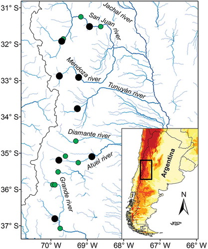
Daily streamflow data from 21 streamgauges were obtained from the hydrological database belonging to the Water Resources Agency of Argentina (http://bdhi.hidricosargentina.gov.ar/). shows the spatial distribution of the streamgauges and the main rivers of the CAA. From these records, eight time series were selected as representative of the climatology (see ), based on the quality of the data, the spatial representativeness and the length of dataset. The names and relevant particulars of the selected streamgauges are summarized in . Several infilling methods were applied for the study area depending on the size of the missing data gap, the hydrological conditions at the site when the gap occurred and the availability of nearby gauging stations, following the recommendations made by WMO (Citation2008) and the methodology used by Vich et al. (Citation2014). We used inference in cases when short gaps occurred (approximately 1–3 d), polynomial interpolation for gaps of 4–30 d, and interpolation from analogue gauging stations for gaps of more than 30 d. The polynomial interpolation was used to fill data mostly during recession flows, using a cubic polynomial curve. Linear regressions between the reference series and data from neighbouring stations were used to complete temporal gaps (>30 d) only for stations that explain more than 80% of the temporal behaviour of streamflow. After this procedure, the time series selected for the climatological assessment had less than 6% of missing data for the period 1957–2014 (57 years, ). Even when not all the cases with missing data were filled, some of the gaps were recorded in wet years (i.e. without drought occurrence), or during the dry season, thus increasing the completeness of the records. Between the headwaters and the location of the streamgauges, there are no major reservoirs or dam constructions that can alter the natural flow and, therefore, the estimation of streamflow drought occurrences.
Table 1. Geographical characteristics of the selected stations, period of record, percentage of missing data and mean streamflow values.
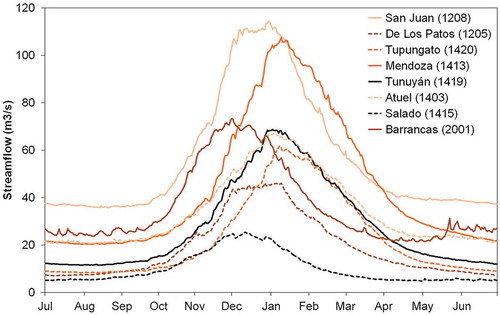
shows the annual hydrological cycle of the eight rivers selected for the climatological analysis. The hydrological cycle is pronounced, with a peak during the southern hemisphere warm season that is associated with snowmelt and glaciermelt due to the increase in temperatures, and the low-flow season during cold winter months. The annual streamflow cycle was defined as the period between 1 July and 30 June. A similar behaviour is observed among the main rivers of the region (), with a peak between November and January in San Juan, De Los Patos, Salado and Barrancas, and between December and February in Tupungato, Mendoza, Tunuyán and Atuel. The length of the high-flow season can be attributed to a migration of snowmelt from lower to higher elevations, which is a common feature in large mountainous catchments. Given that the 0°C isotherm fluctuates from 2930 m in winter to 4090 m in summer (Secretaría de Ambiente y Desarrollo Sustentable de la Nación Citation2015), in a normal year the rivers have a large surface of snow and glaciers that contributes to the streamflow, typically during the months from October to March.
Figure 2. Hydrological cycle of the eight selected rivers for the climatology of streamflow droughts over the CAA.
We used the Oceanic Niño Index (see http://www.cpc.ncep.noaa.gov/products/analysis_monitoring/ensostuff/ensoyears.shtml for details) to define El Niño and La Niña events, being periods when the 3-month running means of ERSST v4 (Huang et al. Citation2015) SST anomalies in the Niño 3.4 region (5°N–5°S, 120°–170°W) were above 0.5°C or below –0.5°C for five consecutive months or more. The PDO index is defined as the leading empirical orthogonal function (EOF) of mean November–March SST anomalies for the Pacific Ocean to the north of 20°N (Mantua et al. Citation1997) and it was obtained through the JISAO website (http://research.jisao.washington.edu/data_sets/).
2.2 Streamflow drought definition
To identify streamflow drought occurrences, we used a threshold level approach, a methodology introduced by Yevjevich (Citation1967) and widely used in recent studies (Fleig et al. Citation2006, Beyene et al. Citation2014, van Loon et al. Citation2015). The threshold levels (also referred to as truncation levels) were derived from the flow–duration curve as the flow equalled or exceeded for 70% (Q70), 80% (Q80) and 90% (Q90) of the time, as indicators of moderate, severe and extreme streamflow droughts, respectively (Rivera et al. Citation2017). The thresholds were selected in order to balance the appearance of multi-year droughts (i.e. droughts lasting longer than 365 d) and zero-drought years (when the flow never falls below the threshold level in a year), both important features when choosing a consistent threshold level (Tallaksen and Hisdal Citation1997). A big advantage of this methodology in comparison with the use of standardized drought indices is that it allows quantification of the deficit volume, which is an important characteristic in water resources management (van Loon Citation2015).
With this methodology, a drought event starts when the flow falls below the threshold, and ends when the threshold is exceeded or when the water deficit volume below the threshold has been replenished (Stahl Citation2001). Taking into account the seasonality in the streamflow records over the study area (see ), we decided to analyse the high-flow season, defined from 1 October to 31 March. The use of a daily varying threshold for the identification of streamflow droughts over the CAA is novel, considering that previous studies used an annual constant threshold level for drought definition (Fernández and Buscemi Citation2000, Díaz et al. Citation2016). In this sense, the methodology represents in a better way the variation of the water demand during the warm season, hence allowing a more adequate quantification of streamflow droughts. Given that the use of the threshold level method applied on daily data introduces the problem of dependency between deficits and minor drought events, the streamflow time series were smoothed with a 7-day moving average prior to the threshold level calculation, following the World Meteorological Organization (WMO) (Citation2008) recommendation.
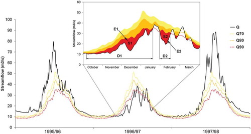
In order to illustrate the streamflow drought definition based on the threshold level method, Figure 3 shows an example of streamflow drought identification through the different thresholds for the Tunuyán River during the hydrological years 1995/96–1997/98. It can be observed that during most of 1995/96 and 1997/98 the streamflow was above the threshold levels, while during 1996/97 the occurrence of moderate, severe and extreme droughts was evident over a large proportion of the year, particularly during the warm season. The methodology allows identification of the onset and end of the streamflow drought events and other parameters, which are shown in for the extreme droughts (streamflow below the Q90 threshold) during October 1996 and February 1997. These characteristics are the number of drought events (E1 and E2); the duration of each event (D1 and D2) and its severity (area between Q90 and Q, i.e. S1 and S2). The threshold levels during the low-flow period are similar and no major deficit volume is recorded during this season, supporting the choice of analysing only the high-flow season.
Figure 3. Comparison of streamflow at Tunuyán River during the period 1995/96–1997/98 with the three different threshold levels calculated with data from 1957/58–2013/14. Darker colours indicate higher drought severity, i.e. progressing from Q70 (moderate drought) to Q90 (extreme drought). A detail of the drought periods during the warm season of the hydrological year 1996/97 is also shown, including an illustration of drought characteristics for two extreme events (E1 and E2), with drought durations D1 and D2 and severities (area between Q90 and Q) S1 and S2, respectively.
shows the streamflow drought parameters used in this study, based on a previous study by Hisdal et al. (Citation2001), which were derived for the high-flow season considering the three selected threshold levels: the seasonal number of drought days (SNDD), the seasonal cumulative deficit volume (SCDV) and the number of drought events per season (SNDE). The SNDD is a duration-based indicator, while the SCDV is a deficit-based indicator and the SNDE reflects the frequency of drought events (Wu et al. Citation2008). These three parameters were calculated as a regional average for the 1957/58–2013/14 period. For the streamflow drought climatology, we also calculated the total number of drought events (TNDE), mean drought duration (MDD) and its mean severity, expressed as the cumulative deficit volume standardized by the mean flow (CDV) (). These statistics provide information about the mean features of streamflow droughts over the eight selected basins for the 1957/58–2013/14 period. In order to eliminate minor droughts that can influence the statistical analysis of drought characteristics (Tallaksen et al. Citation1997), all drought events with duration of less than 10 d were excluded from the analysis. We also excluded events that persisted for less than 20 and 30 d, in order to quantify deficits in streamflow levels that can affect water demand of diverse activities. It is worthwhile to mention that, even when the region is characterized by an arid to semi-arid climate, none of the analysed rivers are intermittent or ephemeral, which guarantees a proper definition of drought events based on the selected thresholds.
Table 2. Streamflow drought parameters used in this study for each of the threshold levels. d: days with observed streamflow below the selected threshold; v: difference between observed streamflow and selected threshold (in m3/s); Q: seasonal mean flow (in m3/s); and E: streamflow drought event.
2.3 Time series analysis
The temporal variability in the time series of hydrological indices predominantly occurs with preferred time scales, often called modes. These modes provide a simplified description of the variations over a study area, and can be linked to variations in climate oscillations. For the estimation of the main modes of variability in the seasonal streamflow drought indices, we used the Complete Ensemble Empirical Mode Decomposition with Adaptive Noise (CEEMDAN) (Colominas et al. Citation2014). This method decomposes a time series in a finite number of components, called intrinsic mode functions (IMF), extracted from high- to low-frequency oscillations, plus a final trend that is either monotonic or constant (Colominas et al. Citation2015). In this sense, we can decompose the original streamflow drought indices into several oscillatory modes of variability and a trend. Therefore, this novel technique has several possible applications in both understanding streamflow drought variability and in drought forecasting at different time scales.
The CEEMDAN approach proves to be an important improvement of the original empirical mode decomposition (EMD) (Huang et al. Citation1998), achieving a negligible reconstruction error and solving the problem of different numbers of modes for different realizations of signal plus noise (Colominas et al. Citation2014). The method is robust in the presence of nonstationary data and is adequate for the study of time series that possesses nonlinear variations, such as most hydroclimatic records (Wu and Huang Citation2009). According to Sang et al. (Citation2014), the EMD can be an effective alternative for trend identification in hydrological time series, hence, this feature also applies to the CEEMDAN approach. Moreover, each of the components (i.e. modes) has a physical meaning and reveals important characteristics of the signal (Autret et al. Citation2013). Below, we present the basic steps of the calculation of the EMD, which show the simplicity of the method. The reader is referred to Colominas et al. (Citation2014, Citation2015) for a full description of the CEEMDAN method and its main advantages with respect to EMD and the ensemble EMD (Wu and Huang Citation2009):
(1) Set k = 0, and define r0 = x(t).
(2) Identify the extremes (maximum and minimum) of rk, and generate the upper (emax) and lower (emin) envelopes connecting all the local extremes through a cubic spline interpolation.
(3) Calculate the mean envelope m = (emin + emax)/2.
(4) Subtract the mean envelope from the time series in order to obtain the first IMF time series hk+1 = rk − m.
(5) Verify whether hk+1 is an IMF. To be considered as an IMF, a signal must fulfill two conditions: (i) the number of extremes (maxima and minima) and the number of zero-crossings must be equal or differ at most by one; and (ii) the local mean, defined as the mean of the upper and lower envelopes must be zero. If hk+1 is an IMF, save hk+1, compute the residue , do k = k + 1 and treat rk as input data in Step 2. If hk+1 is not an IMF, treat hk+1 as r0 and repeat steps 2 to 4 as many times as needed.
(6) Continue until the final residue rk becomes a monotonic function or a function only containing less than three extremes (McMahon et al. Citation2008) from which no more IFM can be extracted. In that case, a complete sifting process of series x(t) by EMD stops. The decomposition results can be expressed as:
The use of the CEEMDAN technique for the identification of the main modes of variability present in hydro-meteorological variables is novel in the study region. Recent studies (Antico et al. Citation2014, Citation2016) have analysed, through CEEMDAN, the temporal variability in the Paraná River, the third largest river in South America, located in La Plata Basin. The technique was also used by Rivera and Penalba (Citation2014) for the assessment of nonlinear trends in the drought-affected area over southern South America.
3 Results
3.1 Streamflow drought climatology: 1957/58–2013/14
lists the climatological values of the streamflow drought parameters for the selected basins during the high-flow season (October–March). Description of the values is given for the droughts that lasted at least 10 d, for the moderate, severe and extreme drought levels. The region with the largest number of streamflow drought events is located upstream of Punta de Vacas, in the headwaters of the Cuevas, Mendoza and Tupungato rivers, and over the Tunuyán basin, with more than 80 drought events in the 57 hydrological years (). De Los Patos, San Juan, Salado and Barrancas basins have a lower number of drought events, ranging between 58 and 64. This is also observed for the severe and extreme events, with values ranging from 42 to 46 and 22 to 26, respectively. There is a clear relationship between the number of drought events and mean duration: the basins where the occurrence of droughts is more frequent corresponds to shorter drought duration, and vice versa. The pattern of fewer but longer streamflow droughts over the northern basins (i.e. De los Patos and San Juan) could be attributed to the geographical morphology (longitudinal extent of the Andes and changes in slope) or an atmospheric process (position on the eastern edge of the South Pacific anticyclone). This feature is also evident over the southern Mendoza basins (Salado and Barrancas rivers). Once a drought event has been established over these basins, it has a mean duration of between 54 and 59 d in the case of the Q70 threshold, between 42 and 45 d for Q80 and between 31 and 51 d for Q90. Moreover, the standard deviation of the duration of droughts is higher than in the rest of the basins, indicating a larger inter-annual variability. In comparison, over most of the Mendoza province basins (Atuel, Mendoza, Tupungato and Tunuyán), mean drought duration is between 20 and 35 d in the case of moderate droughts, with little variation with respect to the selected threshold (). The standardized deficit volume for the eight basins ranges between 18 and 32 d for the Q70 threshold, a parameter that decreases as the severity level increases. The interpretation of the values of deficit volume is related to the number of days per year in which the river would have no flow due to the accumulated streamflow drought conditions. Due to the pooling procedure, the cumulative deficit volume shows an increase as the minor drought duration increases.
Table 3. Climatological values for the total number of drought events (TNDE), mean drought duration (MDD) and cumulative deficit volume standardized by the seasonal mean flow (CDV) for the eight selected basins and their standard deviation (SD) for the Q70, Q80 and Q90 threshold levels and the three levels for minor drought definition.
When considering streamflow drought events with duration longer than 20 d, the statistics show an increase in mean drought duration and a decrease in the number of drought events, in comparison with the results obtained for the streamflow drought events >10 d (). This effect can be interpreted from . For instance, if we consider that D1 = 105 d and D2 = 19 d, mean drought duration during the 1996/97 season is 62 d. Now considering E2 as a minor drought event (i.e. with duration <20 d), mean drought duration will increase to 105 d, and drought frequency will be reduced to a single event. In this sense, similar results are obtained when considering streamflow drought events longer than 30 d (). Similarly, an increase in the mean CDV is observed in all the basins when increasing the duration of the minor droughts.
Comparing the streamflow drought climatology with the climatology of meteorological droughts performed by Rivera (Citation2014), a larger number of meteorological droughts was identified over the region in the period 1961–2008. This could be associated with the fact that not all meteorological droughts, which result from a shortage of precipitation, will eventually lead to a streamflow drought, as suggested by Wong et al. (Citation2013). Meteorological droughts tend to evolve collectively into a prolonged hydrological drought, a feature known as pooling (Van Loon and Van Lanen Citation2012). Moreover, comparing mean drought durations, it is observed that streamflow droughts have longer mean duration than meteorological droughts. In this sense, droughts become longer in duration in moving from meteorological to hydrological drought (Wang et al. Citation2016), a feature known as lengthening. Over the study area, the influence of temperature is another factor that can contribute, with the observed difference in the number of droughts based on precipitation and streamflow records. Abnormally cold seasons can inhibit the snowmelt and glaciermelt processes and, therefore, foster streamflow drought conditions even when rainfall and snowfall amounts are normal (Araneo and Villalba Citation2015).
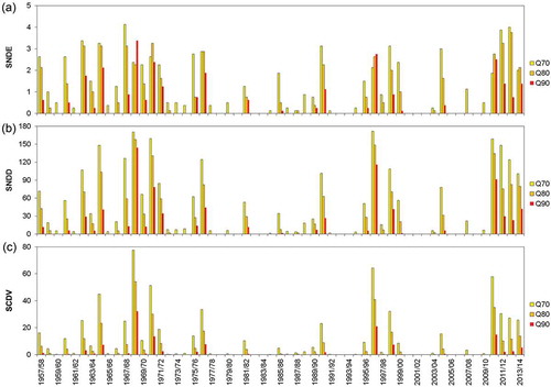
Even when there are spatial differences in the climatological values of the streamflow drought parameters, the regional average of the annual drought indices (SNDD, SCDV and SNDE) can give useful information. This statement is supported by the strong coherence between streamflow time series over the CAA, typically from the Jachal to the Colorado basins (Compagnucci and Araneo Citation2005). Moreover, the correlation coefficients between the time series of the eight basins were calculated, with significant correlations obtained for the three annual indices among all the basins (not shown). The temporal evolution of the regional average of the eight selected stations (, ) for SNDE, SNDD and SCDV is shown in Figure 4((a)–(c)). It is apparent that a dry period occurred from 1957/58 until the end of the 1970s, which is reflected in the high values of the three indices. The end of this dry period is in agreement with historical analysis of precipitation over the CAA, which shows a regime shift between 1976 and 1977 (Compagnucci et al. Citation2002), and also was registered in the snowpack records over the Central Andes (Masiokas et al. Citation2006). In some of the years, the values of the SNDE are higher for the extreme drought category in comparison with the severe and moderate categories ()). This is attributed to the occurrence of dry pulses that are evident considering higher thresholds, a feature that is shown in . For instance, between October and February of 1996/97, three drought events can be identified for the extreme drought level (two of them are labeled as E1 and E2 in ), which are part of two severe drought events and one moderate drought event.
Figure 4. Regional average of the SNDE (a), SNDD (b) and SCDV (c) time series constructed with the eight selected stations for the period 1957/58–2013/14.
During the period 1980–2010 there is a predominance of few drought occurrences, interrupted during the years 1990/91, 1995/96–1999/00 and 2004/05. Since the hydrological year 2010/11, a sharp increase is observed in all the indices, which is a consequence of dry winters during the period 2010–2014 which contributed to poor snow accumulation over the central Andes (Masiokas et al. Citation2014). This recent dry period was also observed in the reduced levels of Cuyo region dams (Diario La Provincia Citation2015) and it is reflected in a water crisis declared by the irrigation departments of Mendoza and San Juan provinces. More details on the long-term variability of these annual time series are given in Section 3.2.
The year 1968/69 shows higher values of regional SNDD and SCDV for the three severity levels, and also higher SNDE for the Q90 threshold (). During the 1967/68–1971/72 period, the regional SNDD was above 60 for the Q70 threshold. Severity shows a peak during the years 1968/69 and 1970/71, with the equivalent of more than 50 days without streamflow for the Q70 threshold in the whole region. This dry period corresponds to the occurrence of the longest and more severe meteorological droughts over central-western Argentina (Rivera Citation2014). Other relevant streamflow droughts occurred during 1975/76–1976/77, 1981/82, 1990/91, 1995/96–1999/00, 2004/05 and 2010/11–2013/14. The 1981/82 and 1990/91 events were particularly strong for the San Juan and De los Patos basins, with over 150 days with streamflow drought conditions, more than half of the days with severe conditions. Based on the SNDD and SCDV, the 2010/11–2013/14 period was record breaking in Tunuyán and Tupungato basins. Also, the SNDE recorded for the Q70 and Q80 thresholds shows large values during the 2011/12–2012/13 period. The 2010/11 year shows the third highest SCDV of the analysed period considering the three severity thresholds.
3.2 Trends and periodicities in SNDD
For a better assessment of the temporal variations in the annual time series, we decided to analyse only the evolution of the seasonal number of drought days (SNDD) identified with the Q70 threshold, given the continuity of the time series (i.e. lack of long periods with zero values) in comparison with the time series based on other thresholds (see )). This is in line with the analysis performed by Rivera and Penalba (Citation2014) for the temporal evolution of meteorological droughts over southern South America. Given the strong relationship between duration (SNDD) and severity (SCDV) for the three different threshold levels (r = 0.946, p < 0.01, see ), we verified that the main modes of variability do not change if we consider the SCDV based on Q70 instead of the SNDD (results not shown).
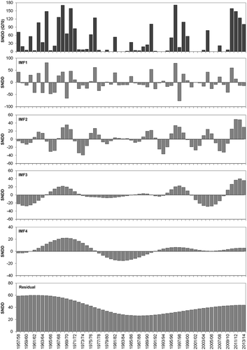
shows the main modes of variability associated with the SNDD for moderate streamflow droughts over the CAA. If we consider the seasons with more than 90 d with streamflow drought conditions, seven of the 14 years (1964/65, 1967/68, 1970/71, 1971/72, 1998/99, 2010/11 and 2011/12) correspond to La Niña years and four (1962/63, 1996/97, 2012/13 and 2013/14) to cold conditions with SST anomalies not reaching the La Niña threshold (). The rest of the years are characterized by warm SST episodes, two of them (1968/69 and 1976/77) being El Niño years. The CEEMDAN approach first extracted the higher-frequency variations from the data, represented by IMF1, and the successive applications of the algorithm produced the remaining IMFs. Low-frequency variations are represented by the higher-order IMFs. The first two modes of variability account for the inter-annual variations in the SNDD, while the remaining IMFs and the residual can be associated with the inter-decadal variability. The IMF1 has an average oscillation of 2.0–3.1 years, with higher amplitude during the first decades of record (). The IMF2 has an average period of 7.0–9.3 years and shows an increase in amplitude since the beginning of the 1990s, which led to an increase in the number of years with excess and dry conditions, also in line with the temporal variability associated with the IMF3 (average oscillation of 11.2–14.0 years). The IMF4 has an average oscillation of 28 years, with amplitude around 20 d which shows a decrease with time. The residual represents a nonlinear trend which shows a reversal in the sign during the second half of the 1980s, a result that has been observed in other hydro-meteorological variables over southern South America (Krepper and Zucarelli Citation2012, Rivera et al. Citation2013, Rivera and Penalba Citation2014) and is indicative of the existence of a low-frequency oscillation that led to an increase in both SNDD and SCDV during the last 20 years. This oscillation fluctuates between 25 and 60 dry days per year.
Figure 5. Decomposition of the SNDD for the Q70 threshold based on the CEEMDAN approach. The top panel shows the original signal, while the rest of the panels show the IMFs and the residual of the decomposition. As expressed in Equation (1) (Section 2.3), the sum of the four IMF and the residual represents the original signal. Notice that the scale of the y-axis changes depending on the amplitude of the IMF considered.
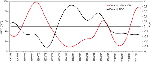
In order to analyse the decadal variations in SNDD, we considered the sum of IMFs 3 and 4, and the residual of the decomposition as a decadal component of the SNDD. We compared this oscillatory mode with the decadal component of the PDO, which was obtained by applying the CEEMDAN method to this time series and grouping the modes 3, 4 and the residual. Figure 6 shows the temporal evolution of the two time series. The occurrences of dry periods (i.e. higher number of dry days) are in phase with negative values of the PDO, which is particularly outstanding during the periods 1967/68–1971/72 and 2010/11–2013/14 (see and ). In addition, both time series are significantly correlated (r = –0.607, p < 0.01), showing that the PDO has a significant influence in the modulation of low frequency of streamflow droughts over the CAA. There is a clear decoupling in the period 1999/00–2008/09; nevertheless, the inter-annual modes of the PDO show positive values, indicating that these modes contribute to the low values of SNDD during this period. The inter-annual contribution of the PDO was also relevant during the dry period 2010/11–2013/14 (result not shown).
Figure 6. Temporal evolution of the decadal components of the PDO and the SNDD based on the Q70 threshold for the period 1957/58–2013/14.
Even when the 1968/69 season seems to be the most extreme regarding the duration (SNDD) and severity (SCDV) of droughts (), and the 1967/68–1970/71 period is highlighted as one of the driest periods of the whole record over the CAA, the consistency in the dry period of the years 2010/11–2013/14 is remarkable, with more than 100 days per season having streamflows below the Q70 threshold, averaged over eight locations.
4 Discussion
Extended periods of rivers flowing with reduced streamflow may have significant impacts on natural ecosystems, social activities and the regional economy. The increase in the demand for water resources to cover environmental needs, to satisfy human and industrial consumption, and for the generation of hydroelectric power, requires an improvement in water management, especially during periods of low streamflows. In the CAA, agriculture is a key activity that is only possible through irrigation (Montaña et al. Citation2016), this region having the largest irrigated surface of Argentina (Morábito et al. Citation2009). Wine production in the region is both the main source of income and the main consumer of water for irrigation (Castex et al. Citation2015). In this sense, streamflow drought periods exacerbate the pressure on water resources, often leading to water conflicts and economic losses. To deal with the recurrent drought conditions over the CAA, farmers and agricultural workers (especially those integrated within the industry or connected to the export chain) have gradually moved away from the foothills to settle in the upper lands, looking for lower temperatures, proximity to water sources, better water quality and less pollution (Montaña et al. Citation2016).
The threshold level method applied to the daily hydrographs of eight representative basins of the CAA allowed us to obtain the main characteristics of streamflow droughts over the last 57 years. These parameters are usually considered in various engineering applications, such as the design of reservoirs and irrigation channels. This new approach for streamflow drought identification (which consists in considering the daily variation of streamflows instead of using a fixed yearly value), can allow a proper evaluation of hydrological conditions, especially in a region with marked seasonality and that can be affected by several types of streamflow droughts, depending on precipitation, temperature or a combination of both. Differences in the mean values of streamflow drought duration and severity, and in the number of drought events, were observed in the northern basins (31–32°S) and in the basins of southern Mendoza province (35–37°S) with respect to those located in central and northern Mendoza (32–35°S). Differences could be attributed to the geographical morphology related to differences in the longitudinal extent of the Andes and to the position of the eastern edge of the South Pacific anticyclone. Both factors could enhance the occurrence of fewer but longer streamflow droughts, with respect to the basins over the central part of Mendoza province. Comparing the Blanco (32°S) and Mendoza (33°S) rivers, Lascano Kezic (Citation2010) identified the contribution of glaciermelt to the streamflow levels during the dry years 1968/69 and 1996/97, with values of 26% and 50%, respectively. This shows that the difference in glaciermelt contribution can be linked to geomorphological differences between the basins, a factor that needs to be further explored. Another factor that can explain the spatial differences in streamflow drought parameters is the intra-seasonal variation of temperature associated with the Madden-Julian Oscillation, which is relevant over the CAA (Álvarez et al. Citation2016). This intra-seasonal variation can act as regulator of the snowmelt and, therefore, modify the streamflow amount during the warm season. Given that the focus of this research is based on inter-annual to inter-decadal variations, further research is needed to establish the role of intra-seasonal variability on streamflow droughts.
With the streamflow drought events identified, we constructed three annual indices based on the streamflow drought climatology for Europe given by Hisdal et al. (Citation2001). These indices account for the number of drought events per season (SNDE), their duration (SNDD) and severity (SCDV). Based on the temporal evolution of these indices during the 1957/58–2013/14 period, a clear relationship is observed between the duration and severity of drought events. Even when this relationship is usually nonlinear and depends on the propagation of droughts (Van Loon et al. Citation2014) related to climatic and catchment characteristics (van Lanen et al. Citation2013), the temporal variability in both time series is similar and can be attributed to the same climatic processes. In this sense, we applied a novel technique (CEEMDAN) to decompose the SNDD time series based on the Q70 threshold, which allowed us to identify the five main modes of variability. This assessment showed the role of ENSO and the PDO in modulating the inter-annual and inter-decadal variations of streamflow droughts. Eleven of the 14 driest years are related to either La Niña events or cold SST conditions over the tropical Pacific Ocean. The decadal modes of the PDO account for 37% of the decadal variations in streamflow droughts, which are marked during the 1957–1999 period. The negative phase of the PDO is in agreement with a larger number of days with streamflow droughts and also with a larger deficit volume, and vice versa. The CEEDMAN method has several possible applications in both understanding streamflow drought variability and its potential for estimating the predictability of streamflow droughts at different time scales.
The design of reservoirs and associated infrastructure is often based on 30- or 50-year average streamflows and the assumption of a steady-state climate (Eden and Lawford Citation2003). Therefore, an approach that considers the nonlinearity of the climatic system must be considered for the development of adaptation and mitigation strategies. The residual of the CEEDMAN approach showed the existence of a nonlinear trend towards an increase in the duration and severity of streamflow drought conditions during recent years. This trend contributed to more than 40 days with low streamflow per season during the last 5 years, reaching the highest values since the late 1970s. Since the hydrological year 2010/11, streamflow drought conditions have developed over the CAA, mostly related to cold SST conditions in the tropical Pacific Ocean. This period had an average value of over 100 yearly days with streamflow drought conditions, standing out as one of the most relevant dry periods of the past century, comparable with the 1967/68–1971/72 period.
During recent decades, several studies have been performed worldwide regarding the climatological aspects of streamflow droughts (Wu et al. Citation2008), the development of streamflow drought indicators for monitoring and drought characterization (Shukla and Wood Citation2008, Vicente-Serrano et al. Citation2012) and the generation of early warning plans to mitigate their impact (Walker and Douglas Citation2003, Garrote et al. Citation2009). There is a need to provide long-term baseline monitoring and analysis of low flows to support integrated river basin management (WMO Citation2008).
5 Conclusions
The hydrological drought conditions over the CAA during the past 57 years were assessed in terms of streamflow variations through the daily varying threshold level method. A climatological assessment of streamflow droughts based on their frequency, mean duration and mean severity allowed us to identify several regional differences in drought characteristics. Basins located north of 32°S or south of 35°S recorded 50% fewer streamflow drought events than the basins in the central part of the study area, a factor that could be related to the geomorphology of the basins or to regional climate conditions. There is a clear relationship between the number of drought events and their mean duration: the basins where the occurrence of droughts is more frequent correspond with shorter drought duration, and vice versa. Regional differences show almost 100% more drought days in the basins with less frequent drought conditions. These results are dependent on the severity level and the minimum drought duration.
Regionally averaged annual indices accounting for the frequency of streamflow drought events (SNDE), their duration (SNDD) and severity (SCDV) were constructed for the temporal analysis of streamflow droughts. Given the significant relationship between severity and duration (streamflow droughts with longer mean duration have large cumulative deficit volumes), we applied the CEEMDAN approach only to the SNDD time series considering the Q70 threshold. This method allowed the identification of both inter-annual and inter-decadal modes of variability, which were linked to El Niño/La Niña occurrences and the PDO. A strong consistency was obtained considering the years with higher values of SNDD and the relationship to La Niña events or to cold SST conditions (not reaching the La Niña threshold) over the tropical Pacific Ocean. Regarding the decadal variations in streamflow drought periods, the contribution of the PDO is more relevant during the 1957/58–1998/99 period. Looking at the recent drought period (2010/11–2013/14), the PDO accounts for half of the precipitation trends recorded in the Central Andes (Boisier et al. Citation2016), suggesting that anthropogenic forcing may be playing a role in drought persistence. Between 2010/11 and 2013/14, for almost 60% of the period, streamflows were below the Q70 threshold, highlighting this dry period as one of the most prolonged on record. We recommend a continuous regional monitoring of streamflow time series based on a daily threshold level, with the objective to optimize the management of hydrological resources that are being reduced and are becoming inadequate for the needs of the agricultural sector, the generation of hydropower and human requirements.
Acknowledgements
We thank the Subsecretaría de Recursos Hídricos de Argentina for providing the hydro-meteorological records used in the study.
Disclosure statement
No potential conflict of interest was reported by the authors.
Additional information
Funding
Related Research Data
References
- Álvarez, M.S., et al., 2016. Influence of the Madden Julian Oscillation on precipitation and surface air temperature in South America. Climate Dynamics, 46 (1), 245–262. doi:10.1007/s00382-015-2581-6
- Antico, A., Schlotthauer, G., and Torres, M.E., 2014. Analysis of hydro-climatic variability and trends using a novel empirical mode decomposition: application to the Paraná River Basin. Journal of Geophysical Research: Atmospheres, 119, 1218–1233.
- Antico, A., Torres, M.E., and Diaz, H.F., 2016. Contributions of different time scales to extreme Paraná floods. Climate Dynamics, 46 (11), 3785–3792. doi:10.1007/s00382-015-2804-x
- Araneo, D. and Villalba, R., 2015. Variability in the annual cycle of the Río Atuel streamflows and its relationship with tropospheric circulation. International Journal of Climatology, 35 (10), 2948–2967. doi:10.1002/joc.2015.35.issue-10
- Autret, G., Rémy, F., and Roques, S., 2013. Multiscale analysis of Antarctic surface temperature series by empirical mode decomposition. Journal of Atmospheric and Oceanic Technology, 30, 649–654. doi:10.1175/JTECH-D-11-00050.1
- Beyene, B.S., et al., 2014. Investigation of variable threshold level approaches for hydrological drought identification. Hydrology and Earth System Sciences Discussions, 11, 12765–12797. doi:10.5194/hessd-11-12765-2014
- Boisier, J.P., et al., 2016. Anthropogenic and natural contributions to the Southeast Pacific precipitation decline and recent megadrought in central Chile. Geophysical Research Letters, 43 (1), 413–421. doi:10.1002/2015GL067265
- Boninsegna, J. and Villalba, R., 2006. Los escenarios de Cambio Climático y el impacto en los caudales. Documento sobre la oferta hídrica en los oasis de riego de Mendoza y San Juan en escenarios de Cambio Climático. Buenos Aires: Secretaría de Ambiente y Desarrollo Sustentable.
- Bruniard, E., 1982. La Diagonal Árida Argentina: un límite climático real. Revista Geográfica, 95, 5–20.
- Carril, A.F., et al., 1997. Impacts of climate change on the oases of the Argentinean cordillera. Climate Research, 9, 121–129. doi:10.3354/cr009121
- Castex, V., Morán Tejada, E., and Beniston, M., 2015. Water availability, use and governance in the wine producing region of Mendoza, Argentina. Environmental Science & Policy, 48, 1–8. doi:10.1016/j.envsci.2014.12.008
- Colominas, M.A., Schlotthauer, G., and Torres, M.E., 2014. Improved complete ensemble EMD: A suitable tool for biomedical signal processing. Biomedical Signal Processing and Control, 14, 19–29. doi:10.1016/j.bspc.2014.06.009
- Colominas, M.A., Schlotthauer, G., and Torres, M.E., 2015. An unconstrained optimization approach to empirical mode decomposition. Digital Signal Processing, 40, 164–175. doi:10.1016/j.dsp.2015.02.013
- Compagnucci, R.H., Agosta, E.A., and Vargas, W.M., 2002. Climatic change and quasi-oscillations in central-west Argentina summer precipitation: main features and coherent behaviour with southern African region. Climate Dynamics, 18, 421–435. doi:10.1007/s003820100183
- Compagnucci, R.H. and Araneo, D.C., 2005. Identificación de áreas de homogeneidad estadística para los caudales de ríos andinos argentinos y su relación con la circulación atmosférica y la temperatura superficial del mar. Meteorológica, 30 (1–2), 41–53.
- Compagnucci, R.H. and Araneo, D.C., 2007. Alcances de El Niño como predictor del caudal de los ríos andinos argentinos. Ingeniería Hidráulica En México, 22 (3), 23–35.
- Compagnucci, R.H. and Vargas, W.M., 1998. Interannual variability of Cuyo rivers streamflow in Argentinean Andean Mountains and ENSO events. International Journal of Climatology, 18, 1593–1609. doi:10.1002/(SICI)1097-0088(19981130)18:14<1593::AID-JOC327>3.0.CO;2-U
- Contreras, S., et al., 2011. Remote sensing estimates of supplementary water consumption by arid ecosystems of central Argentina. Journal of Hydrology, 397, 10–22. doi:10.1016/j.jhydrol.2010.11.014
- Díaz, E., et al., 2016. Identificación y caracterización de sequías hidrológicas en Argentina. Tecnología Y Ciencias Del Agua, 7 (1), 125–133.
- Eden, S. and Lawford, R.G., 2003. Using science to address a growing worldwide water dilemma for the 21st century. In: R.G. Lawford, et al., eds. Water: science, policy and management: challenges and opportunities. Washington, DC, EstadosUnidos: American Geophysical Union, 15–41. doi:10.1029/016WM19
- Fernández, H.W. and Buscemi, N.H. 2000. Análisis y caracterización de sequías hidrológicas en el Centro Oeste de Argentina. In: Proceedings of the XVIII Congreso Nacional del Agua (CONAGUA), 12-16 June 2000 Termas de Río Hondo. Santiago del Estero: Universidad Nacional de Santiago del Estero.
- Fleig, A.K., et al., 2006. A global evaluation of streamflow drought characteristics. Hydrological and Earth System Sciences, 10, 535–552. doi:10.5194/hess-10-535-2006
- Garrote, L., Iglesias, A., and Flores, F., 2009. Development of drought management plans in Spain. In: A. Iglesias, et al., eds. Coping with drought risk in agriculture and water supply systems. Dordrecht: Springer, 175–186. (Advances in Natural and Technological Hazards Research Vol. 26). 978-1-4020-9044-8
- Hisdal, H., et al., 2001. Have streamflow droughts in Europe become more severe or frequent? International Journal of Climatology, 21, 317–333. doi:10.1002/(ISSN)1097-0088
- Huang, B., et al., 2015. Extended reconstructed sea surface temperature version 4 (ERSST.v4). Part I: upgrades and intercomparisons. Journal of Climate, 28, 911–930. doi:10.1175/JCLI-D-14-00006.1
- Huang, N.E., et al., 1998. The empirical mode decomposition method and the Hilbert spectrum for non-stationary time series analysis. Proceedings of the Royal Society London, 454A, 903–995. doi:10.1098/rspa.1998.0193
- INDEC, 2010. Censo Nacional de Población, Hogares y Viviendas 2010 [online]. Instituto Geográfico Nacional (IGN). Available from: http://www.sig.indec.gov.ar/censo2010/ [Accessed 11 May 2017].
- Krepper, C.M. and Zucarelli, V., 2012. Climatology of water excess and shortages in the La Plata Basin. Theoretical and Applied Climatology, 102, 13–27. doi:10.1007/s00704-009-0234-6
- Diario La Provincia, 2015. La crisis hídrica golpea más a San Juan que a Mendoza [online]. Available from: http://www.diariolaprovinciasj.com/sociedad/2015/3/24/crisis-hidrica-golpea-juan-mendoza-28422.html [Accessed 11 May 2017].
- Lascano Kezic, M.E., 2010. Contribución de glaciares al caudal de los ríos en los Andes centrales de la Argentina durante años de sequía extraordinaria. Contribuciones Científicas, 22, 1–10.
- Mantua, N.J., et al., 1997. A Pacific interdecadal climate oscillation with impacts on salmon production. Bulletin of the American Meteorological Society, 78, 1069–1079. doi:10.1175/1520-0477(1997)078<1069:APICOW>2.0.CO;2
- Masiokas, M., et al., 2006. Snowpack variations in the Central Andes of Argentina and Chile, 1951-2005: large-scale atmospheric influences and implications for water resources in the region. Journal of Climate, 19, 6334–6352. doi:10.1175/JCLI3969.1
- Masiokas, M.H., et al., 2012. Snowpack variations since AD 1150 in the Andes of Chile and Argentina (30°–37°S) inferred from rainfall, tree-ring and documentary records. Journal of Geophysical Research, 117, D05112. doi:10.1029/2011JD016748
- Masiokas, M.H., et al., 2014. Recent snowpack and streamflow variations in the Central Andes of Chile and Argentina. In: B.H. Luckman, ed. Documenting, Understanding and Projecting Changes in the Hydrological Cycle in the American Cordillera, 6-9 October Los Reyunos. San Rafael: Inter-American Institute for Global Change Research (IAI), Vol. 47.
- McIntyre, O., 2007. Environmental protection of international water courses under international law. Hampshire: Ashgate Publishing Limited.
- McMahon, T.A., et al., 2008. A new approach to stochastically generating six-monthly rainfall sequences based on Empirical Mode Decomposition. Journal of Hydrometeorology, 9, 1377–1389. doi:10.1175/2008JHM991.1
- Montaña, E., Diaz, H.P., and Hurlbert, M., 2016. Development, local livelihoods, and vulnerabilities to global environmental change in the South American Dry Andes. Regional Environmental Change, 16 (8), 2215–2228. doi:10.1007/s10113-015-0888-9
- Morábito, J., et al., 2009. El agua en Mendoza y su problemática ambiental. Mendoza: Centro Regional Andino, Instituto Nacional del Agua (CRA-INA).
- Prieto, M.R., Araneo, D., and Villalba, R., 2012. The great droughts of 1924-25 and 1968-69 in the Argentinean central Andes. Impacts and responses. In: Proceedings of the XI Congreso Nacional de Meteorología, 28 May-1 June, Mendoza. Mendoza: Centro Argentino de Meteorólogos (CAM).
- Rivera, J.A., 2014. Aspectos climatológicos de las sequías meteorológicas en el Sur de Sudamérica. Análisis regional y proyecciones futuras. Thesis (PhD). University of Buenos Aires.
- Rivera, J.A., et al., 2017. Regional aspects of streamflow droughts in the Andean rivers of Patagonia, Argentina. Links with large-scale climatic oscillations. Hydrology Research. doi:10.2166/nh.2017.207
- Rivera, J.A. and Penalba, O.C., 2014. Trends and spatial patterns of drought affected area in Southern South America. Climate, 2, 264–278. doi:10.3390/cli2040264
- Rivera, J.A., Penalba, O.C., and Bettolli, M.L., 2013. Inter-annual and inter-decadal variability of dry days in Argentina. International Journal of Climatology, 33, 834–842. doi:10.1002/joc.3472
- Sang, Y.-F., Wang, Z., and Liu, C., 2014. Comparison of the MK test and EMD method for trend identification in hydrological time series. Journal of Hydrology, 510, 293–298. doi:10.1016/j.jhydrol.2013.12.039
- Schwerdtfeger, W., 1976. The atmospheric circulation over Central and South America. In: W. Schwerdtfeger, ed. Climates of Central and South America. Amsterdam/Oxford/New York: Elsiever Scientific Publishing Company, 2–12.
- Secretaría de Ambiente y Desarrollo Sustentable de la Nación, 2015. Tercera Comunicación Nacional de la República Argentina a la Convención Marco de las Naciones Unidas sobre Cambio Climático. Cambio climático en Argentina; tendencias y proyecciones. Buenos Aires: Secretaría de Ambiente y Desarrollo Sustentable de la Nación.
- Shukla, S. and Wood, A.W., 2008. Use of a standardized runoff index for characterizing hydrologic drought. Geophysical Research Letters, 35, L02405. doi:10.1029/2007GL032487
- Stahl, K., 2001. Hydrological drought - A study across Europe. Thesis (PhD). Albert-Ludwigs-Universität.
- Tallaksen, L.M. and Hisdal, H., 1997. Regional analysis of extreme streamflow drought duration and deficit volume. International Association of Hydrological Sciences, 246, 141–150.
- Tallaksen, L.M., Madsen, H., and Clausen, B., 1997. On the definition and modelling of stream-flow drought duration and deficit volume. Hydrological Sciences Journal, 42 (1), 15–33. doi:10.1080/02626669709492003
- Tallaksen, L.M. and van Lanen, H.A.J., eds., 2004. Hydrological drought: processes and estimation methods for streamflow and groundwater. In: Developments in water science. Amsterdam: Elsevier Science B.V.
- van Lanen, H.A.J., et al., 2013. Hydrological drought across the world: impact of climate and physical catchment structure. Hydrology and Earth System Sciences, 17, 1715–1732. doi:10.5194/hess-17-1715-2013
- van Loon, A.F., 2015. Hydrological drought explained. WIREs Water 2015, 2, 359–392. doi:10.1002/wat2.1085
- van Loon, A.F., et al., 2015. Hydrological drought types in cold climates: quantitative analysis of causing factors and qualitative survey of impacts. Hydrology and Earth System Sciences, 19, 1993–2016. doi:10.5194/hess-19-1993-2015
- van Loon, A.F., et al., 2014. How climate seasonality modifies drought duration and deficit. Journal of Geophysical Research: Atmospheres, 119, 4640–4656.
- van Loon, A.F. and van Lanen, H.A.J., 2012. A process-based typology of hydrological drought. Hydrology and Earth System Sciences, 16, 1915–1946. doi:10.5194/hess-16-1915-2012
- Vicente-Serrano, S.M., et al., 2012. Accurate computation of a streamflow drought index. Journal of Hydrologic Engineering, 17 (2), 318–332. doi:10.1061/(ASCE)HE.1943-5584.0000433
- Vich, A.I.J., López, P.M., and Schumacher, M.C., 2007. Trend detection in the water regime of the main rivers of the Province of Mendoza, Argentina. GeoJournal, 70, 233–243. doi:10.1007/s10708-008-9136-x
- Vich, A.I.J., Norte, F.A., and Lauro, C., 2014. Análisis regional de frecuencias de caudales de ríos pertenecientes a cuencas con nacientes en la Cordillera de los Andes. Meteorologica, 39 (1), 3–26.
- Villalba, R., et al., 2016. Cambio climático y recursos hídricos. El caso de las tierras secas del oeste argentino. Ciencia Hoy, 25 (149), 48–55.
- Walker, F.R. and Douglas, E.M., 2003. Identifying hydrologic variability and change for strategic water system planning and design. In: R.G. Lawford, et al., eds. Water: science, policy and management: challenges and opportunities. Washington, DC: American Geophysical Union, 267–284.
- Wang, W., et al., 2016. Propagation of drought: from meteorological drought to agricultural and hydrological drought. Advances in Meteorology, 2016, ID 6547209.
- Wong, G., van Lanen, H.A.J., and Torfs, P.J.J.F., 2013. Probabilistic analysis of hydrological drought characteristics using meteorological drought. Hydrological Sciences Journal, 58 (2), 253–270. doi:10.1080/02626667.2012.753147
- World Meteorological Organization (WMO), 2008. Manual on Low-flow Estimation and Prediction. Geneva: WMO, No. 1029.
- Wu, H., et al., 2008. Trend analysis of streamflow drought events in Nebraska. Water Resources Management, 22 (2), 145–164. doi:10.1007/s11269-006-9148-6
- Wu, Z. and Huang, N.E., 2009. Ensemble empirical mode decomposition: a noise-assisted data analysis method. Advances in Adaptive Data Analysis, 1 (1), 1–41. doi:10.1142/S1793536909000047
- Yevjevich, V., 1967. An objective approach to definition and investigation of continental hydrologic droughts. Fort Collins, CO: Colorado State University.