
 ?Mathematical formulae have been encoded as MathML and are displayed in this HTML version using MathJax in order to improve their display. Uncheck the box to turn MathJax off. This feature requires Javascript. Click on a formula to zoom.
ABSTRACT
The hydrological response of shallow ponds to groundwater withdrawal has been of growing concern in the Doñana National Park (southern Spain) in recent decades. This study examines the role of groundwater in maintaining the hydroperiod (i.e. the hydrological regime) in the park’s main dune ponds, by quantifying the groundwater fluxes to/from them. The hydrological characterization was performed by applying different methodologies. Daily hydrological balances registered in the ponds revealed groundwater contributions ranging from 80% of the total water inflows (i.e. groundwater discharge) to a net groundwater recharge from the ponds to the aquifer, and enabled the studied water bodies to be classified as discharge or recharge systems. The recharge systems must have been influenced by the lowering of piezometric levels due to groundwater extraction for urban supply in a nearby coastal resort.
Editor A. Castellarin Associate editor S. Lyon
1 Introduction
The demand for fresh groundwater is especially significant in arid regions (Kundzewicz and Doell Citation2009), including Spain, which is the most arid country in Europe (Llamas Citation2003). Groundwater demand for different uses has increased rapidly over the past four decades. This increase results in conflicts between wetlands conservation and groundwater exploitation.
Even though the majority of the most significant wetlands at an international level are protected, they are still endangered by a range of pressures (Scheffer et al. Citation2015). Severe degradation of numerous important wetlands, such as mangroves (Sakho et al. Citation2011, Jaramillo et al. Citation2018) or dune slacks (Geelen et al. Citation2017), has been caused by, for example, modification of hydrological connectivity, groundwater withdrawal and surface water pollution (Green et al. Citation2017). In addition, climate change is widely expected to increase the stress on these and other wetlands, although they are not jeopardized by any local stressor (Junk et al. Citation2013). Given the importance of wetlands in preserving landscape biodiversity, further research is necessary. Their richness and diversity may to some extent be linked to their basin characteristics, as they are sinks for substances draining from their catchments and typically reflect local natural variations in geology, hydrology and plant communities (Rodríguez-Rodríguez Citation2007). The conservation of Doñana National Park (DNP) is particularly challenging, requiring coordinated action between water authorities and stakeholders (Maltby and Acreman Citation2011).
The coastal sector of the DNP consists of a major deposit of aeolian sands, including both a mobile and a stabilized dune system. These sands contain more than three thousand ponds, the majority of them flooded only after rainy periods (Green et al. Citation2016). The DNP contains a large seasonal marsh formed by the siltation of the former Guadalquivir River Delta. The originally tidal marsh is no longer influenced by the sea. In addition, more than three-quarters of the original marsh has been modified by human activities since the beginning the 20th century, mostly for the development of new rice crop agriculture in this part of Spain. The area has been granted protected status since 1969 when it was declared a National Park. Later on, it was designated a Wetland of International Importance by the Ramsar Convention in 1982, a Special Protection Area for birds in 1988, and a natural World Heritage Site by the United Nations Educational Scientific and Cultural Organization (UNESCO) Convention in 1994. In recent years, there have been controversies due to the fact that the Doñana wetlands could be classed as being “in danger” by UNESCO if the Spanish authorities do not take the proper measures to solve a number of potential threats to the National Park: impacts from infrastructural projects such as a gas storage facility, the re-opening of the Aznalcollar mine upstream, unsustainable groundwater extractions, and the Guadalquivir River dredging project (UNESCO Citation2017). If this new classification comes to pass, Spain could be the first EU country with a National Park listed as being “in danger”. Water for irrigation and human consumption is being taken out of the aquifer. Groundwater extraction for irrigation totals 60–90 × 106 m3 per year. Extractions for urban water supply are in excess of 2.75 × 10⁶ m3 per year in a nearby coastal resort located on the southwest border of the park (Dimitriou et al. Citation2017).
With respect to the marshes, the “Doñana 2005” plan was implemented after a mining accident in a nearby town (Aznalcollar), outside the limits of the National Park, which had devastating consequences for the entire ecosystem. It involved the restoration of the marshes as well as improvement of the quantity and quality of water from the streams entering the wetland (Meharg et al. Citation1999).
Regarding the sand dune ponds, these ecosystems are of remarkable singularity in Europe, due to the fact that they are a biologically important habitat, renowned both for their specialized assemblages among aquatic organisms such as macroinvertebrates and for the considerable number of rare and endemic species they sustain (Serrano et al. Citation2008). The protection of these ecosystems became an international issue in 1990. Even during the fourth meeting of the Ramsar Convention, the risk of ecological changes, such as the disappearance of some of the ponds and the loss of streams, was highlighted by Suso and Llamas (Citation1993). Even though the aquifer of the stabilized dunes is mainly formed by sands, there are also less permeable deposits – clays and organic silt – at different depths in the deepest parts of the dune slacks, which contribute to the hydrogeological complexity of this system (Custodio et al. Citation2009). The formation of temporary ponds in certain areas is, therefore, conditioned by local groundwater discharge sectors of the aquifer and, probably, by the presence of low permeability materials at depth. The hydrogeological literature published about the hydrology of the Doñana coastal wetlands has highlighted that the ponds which show an anthropogenic alteration of the hydrological regime, or hydroperiod, are the ones located nearest to the above-mentioned coastal resort, where declines in piezometric levels are sharper (e.g. Charco del Toro pond, ). This effect was shown by Olías Alvarez and Rodríguez-Rodríguez (Citation2013), who found that, from 1992 to 2012, the most drastic declines in piezometric levels were located in the surroundings of the irrigated cropland, reaching more than 6 m in deep piezometers.
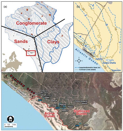
Figure 1. (a) Doñana aquifer and location of the Doñana National Park in Europe. (b) Isopotentiometric map of the eastern part of the dune aquifer (modified from Lozano-Tomás Citation2007). (c) Location of the study area and the pumping site of the coastal resort. The Charco del Toro, Zahillo (ZAH), Santa Olalla (SOL) and Sopeton (SOP) ponds are marked. Palacio de Doñana meteorological station can also be seen. All of these ponds and sensors are located over the stabilized dunes. P: piezometers.
The leading objective of this study is to achieve better knowledge of the groundwater–surface water interactions in some of the ponds located in the DNP. Partial objectives involve: (1) assessing the possible hydrological impact on the temporary ponds due to groundwater withdrawal in nearby areas by analysing daily piezometric tendencies over a period of almost four years (2013–2016); and (2) studying the hydrological functioning of the main ponds in the area by means of daily water balances, piezometric analysis and surface and groundwater hydrochemistry.
2 Study site
The Doñana aquifer ()) covers more than 2500 km2, in the mouth of a 57 000-km2 basin (the Guadalquivir River basin). Its thickness is between 10 m in the north and more than 200 m at the southern coastal border. The impervious materials that underlie the aquifer are marls of Miocene age (Custodio et al. Citation1992). The aquifer is divided into two sectors: confined (marshland) and unconfined (conglomerates and sands). The hydraulic parameters of the materials vary from north to south. Transmissivity ranges from 10−4 to 10−2 m2/s near the coast. In addition, the storage coefficient varies between 5 × 10⁻⁴ in the marshland and 3 × 10⁻² in the unconfined part. The ponds studied sit over the unconfined aquifer, classified by Vela (Citation1984) as a “dune aquifer”, which has a surface area of 90 km2 and stretches from the Atlantic Ocean to the marshes. It receives direct recharge from rainfall and it is made up mainly of permeable aeolian sands ()), with the presence of lenticular bodies of silt and clay. The water table is very close to the surface, at between 1 and 10 m below ground level (Olías et al. Citation2008). The aeolian sands overlie a deeper and more permeable layer comprised of coarser materials of fluvio-deltaic origin (Custodio et al. Citation1992). All the aquatic ecosystems (rivers, seasonal and permanent ponds, etc.) in the DNP rely on groundwater inputs from the aquifer (De Castro and Muñoz-Reinoso Citation1997). As explained above, groundwater withdrawal of more than 60 × 106 m3 by wells, hundreds of them illegal, has had a hydrological impact in some zones. Furthermore, there are several signs of alterations, such as changes in vegetation and a drop in the water levels in the ponds near a coastal resort due to pumping activity (Serrano and Serrano Citation1996, Muñoz-Reinoso Citation2001, Serrano and Zunzunegui Citation2008, Manzano et al. Citation2009, Custodio Citation2010). The total disappearance of two sand dune ponds strengthens the evidence for this. Nearest to the coastal resort, the Brezo pond has been dry since 1976 (Hollis et al. Citation1989) and the Charco del Toro pond ()) has been dry since 2010 (Díaz-Paniagua and Aragones Citation2015).
This research focuses on three ponds located in the Doñana Biological Reserve. This reserve (6800 ha) is located within the boundaries of the DNP and enjoys the highest level of conservation status amongst the Doñana Protected Areas. Activities in the area are restricted to scientific research and the implementation of wildlife conservation programmes. The ponds are located on the west side of the reserve, over stabilized and vegetated dunes (). The distance from the study area to the Atlantic Ocean is up to 2 km.
shows the Doñana aquifer and the location of the Matalascañas coastal resort, as well as the study zone with the location of the Brezo, Charco del Toro, Zahillo, Santa Olalla and Sopeton ponds. The location of the piezometers is also shown. The last three ponds are the subject of this study, referred to henceforth by the abbreviations ZAH, SOL and SOP, respectively.
The climate in the study area is Mediterranean, classified as dry sub-humid with Atlantic influences, characterized by a high inter- and intra-annual variability (Florencio et al. Citation2009). The dry season lasts from April to September. The annual average rainfall is between 500 and 600 mm (Dimitriou et al. Citation2017). The annual potential evapotranspiration is estimated to be 900 mm and free surface evaporation 1500 mm (Suso and Llamas Citation1993). Mean monthly temperatures are about 25°C in July and 10°C in January.
The Doñana aquifer has an estimated annual recharge of 174 × 106 m3 coming from the direct infiltration of precipitation in the unconfined part of the aquifer (IGME Citation2007). Discharge goes mainly to the sea via the sand dune aquifer, to the main watercourses, to the marshlands and, finally, to the ponds, which are the main groundwater-dependent ecosystems in the area. The damping effect of groundwater discharge is vital for the maintenance of these ecosystems, since it provides a more continuous water input than that provided by rainfall.
3 Methodology
To conduct the water-level monitoring, sensors that measure the total pressure at a 3-h time interval (Diver, Level-logger and CTD-Decagon) were installed in each of the piezometers and ponds shown in ). Atmospheric pressure transducers were installed nearby to compensate for the measurements of the above-mentioned sensors. Also, measurements taken directly in the field were used to calibrate the automatic measurements of the sensors.
A conceptual model () developed by Rodríguez-Rodríguez et al. (Citation2016) was followed to define the components of the hydrological budget in the ZAH, SOL and SOP ponds. Groundwater net flux (GWNF) was the unknown variable in the water balance equation:
Figure 2. Hydrological sketch of the Santa Olalla pond and its relation to the coastal aquifer.
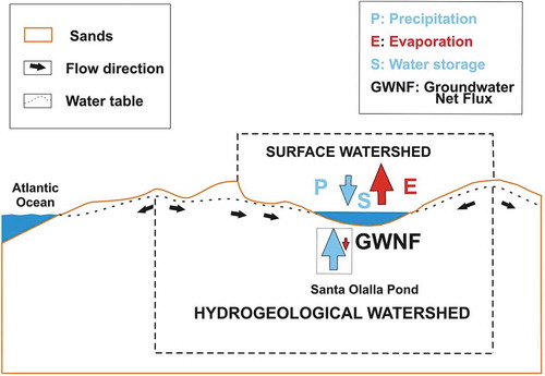
where E is the direct evaporation from the water surface; P is direct precipitation; and ∆S is the change in the water stored.
Data obtained from weather stations () were used to estimate both water inputs (P) and outputs (E). Water outputs were estimated following the best method to calculate losses by evaporation from shallow water bodies (McMahon et al. Citation2013). This method is based on the original Penman formula (Penman Citation1956), which is a semi-empirical equation combining mass transfer and energy budget methods. Variables needed to calculate E are air temperature, relative humidity, solar radiation and wind speed, as well as other parameters. Such data were obtained at a daily time step from the meteorological station located approximately 12 km to the north of the SOL pond (). Changes in the volume of water stored in the ponds (∆S) were quantified using the hypsometric curve. The hypsometric curve of a pond relates the horizontal cross-sectional area of the pond basin to the water level recorded by sensors. The curves were estimated using the equation developed by Hayashi and Van der Kamp (Citation2000), and were used to determine the surface of each of the ponds at a daily time step to calculate the volume and ascertain the variation in storage in each pond.
No streams or ephemeral creeks are found in the area. Given the high permeability of the sands, surface runoff does not need to be accounted for in the water balance equation.
The water balance calculations for the three ponds were carried out between December 2016 and June 2017 and from February to June 2018, adapted to the flooding period of the ZAH pond.
Equation (2) gives an estimation of hydraulic gradients (HG) from piezometers close to the SOL pond:
where ∆h is the difference between the daily water table of each piezometer and the water level in the SOL pond (in m a.s.l.); and ∆x is the distance from each piezometer to the pond.
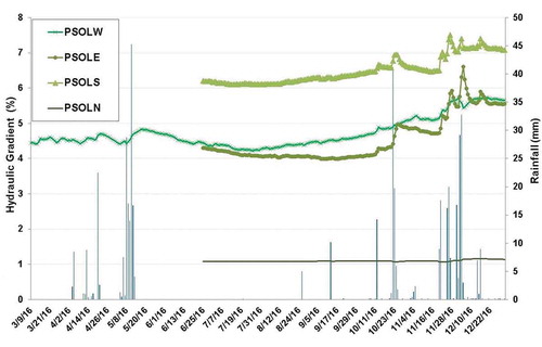
The piezometers used to calculate the hydraulic gradient (see ), are: PSOLN (3.5 m deep), PSOLE (2.7 m deep), PSOLS (2.7 m deep) and PSOLW (17.2 m deep).
The hydrochemical facies of the water samples were obtained with a Dionex ICS-1000 ionic chromatograph. Bicarbonate analysis was carried out by means of colourimetry. Hydrochemical data for the period April 2016–May 2018 were processed using AquaChem software (Waterloo Hydrogeologic).
4 Results
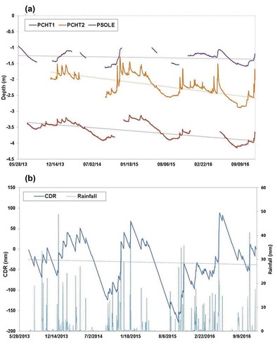
The basic hydrological and morphometric characteristics of the ponds studied are given in . The values for salinity and water depth correspond to the year 2016. Piezometric levels measured between 2013 and 2016 are shown in . The variations in two close piezometers located in the Charco del Toro area, (PCHT1, close to the pond bed, and PCHT2, on the pond bed; both less than 1 km away from the coastal resort) were compared with those observed in the PSOLE piezometer, around 4.6 km away from the resort () and the cumulative deviation of the rainfall (CDR). Slopes of the linear variations obtained in the time series were negative. Nevertheless, the slope of PSOLE (−9 × 10⁻⁵) is smaller than those of PCHT1 (−5 × 10⁻⁴) and PCHT2 (−7 × 10⁻⁴). A linear regression model was made for the slopes of the piezometer values and also for the slope of the CDR rainfall time series. The results show that, for PCHT1 and PCHT2, there is a very significant decreasing trend of the piezometric time series evolution (p = 2.2 × 10⁻¹⁶ in both cases), whereas for PSOLE and CDR, the trends were found to be not significant (p = 0.778) and not very significant (p = 0.020), respectively.
Table 1. Hydrological and morphometric indexes of the ponds studied. AFS: average flooded surface; WS: watershed surface.
Figure 3. (a) Water table evolution over four years in three piezometers (data provided by the Guadalquivir River Basin Authority). (b) Daily rainfall values and cumulative deviation of the mean rainfall (CDR) for the same time period. Trend lines are drawn in all cases.
The results of the water balance in the ZAH, SOL and SOP ponds (December 2016–June 2017 and February–June 2018, during which periods the ponds were flooded) are presented in . Daily water inputs (rainfall) and outputs (evaporation), as well as the variation in storage (∆S) are shown. The GWNF was calculated from Equation (1). In the first period ((a)), the maximum recharge from the pond to the aquifer for ZAH, SOP and SOL was, respectively, −44, −36 and −37 mm/d, in all cases after precipitation events. The total input due to direct rainfall in this period was 301 mm, while the total specific flow of GWNF was 426, 511 and 890 mm, respectively (). It must be emphasized that the median value of GWNF in ZAH (0.25 mm/d) differs by an order of magnitude from those of SOP and SOL (2.60 and 2.25 mm/d, respectively), which indicates a significant difference in their hydrological functioning. The main loss of water in all cases was by evaporation. The ∆S also demonstrates the hydrological tendencies in the ponds. While the total ∆S of the SOL and SOP ponds was positive, that of the ZAH pond was negative, which means that the overall tendency of the latter pond during the period was to decrease. In (b), which shows the water balances of the ZAH, SOL and SOP ponds for February–June 2018, total rainfall is similar to that for the first period (320 mm), although evaporation was higher in the first period (743 vs 562 mm). One of the main differences in this second period is that daily median specific flow in ZAH pond was found to be negative (–0.36 mm/d), in contrast with those of SOL (2.32 mm/d) and SOP (1.05 mm/d). As for the other components of the water balance, values obtained for daily average, minimum and maximum were not very different from those found in the earlier period of the study.
Table 2. Water balance in the Zahillo, Santa Olalla and Sopeton ponds: (a) 3 December 2016–14 June 2017 and (b) 28 February–20 June 2018. GWNF: groundwater net flux; negative values of GWNF are considered to be water outputs from the pond to the aquifer, i.e. groundwater recharge. ∆S: change in water stored.
The results of the hydraulic gradients calculated between the four piezometers () and the SOL pond are presented in , which shows that all hydraulic gradients had a positive value, meaning flows were from the piezometers to the pond. Piezometer PSOLS was found to have the highest hydraulic gradient to the SOL pond, while PSOLN had the lowest. This low gradient was due to the considerable distance – more than 600 m – between PSOLN and the SOL pond. Piezometers PSOLW and PSOLE showed similar variations, although some differences in their behaviour could also be observed. Piezometers PSOLE and PSOLS, which are shallower than PSOLW and PSOLN, showed sharp increases in their hydraulic gradient values when precipitation events took place.
Figure 4. Daily values of hydraulic gradients towards the SOL pond and rainfall from March to December 2016.
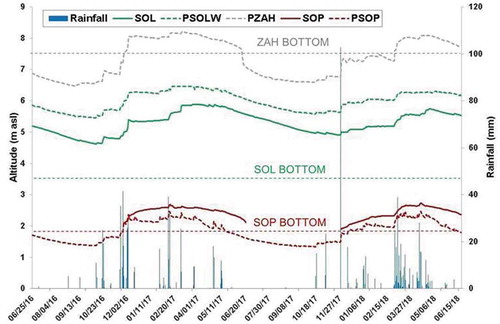
shows the evolution of the piezometric level in the piezometers near the study ponds, as well as the evolution of the surface water during the period 24 June 2016–20 June 2018. The elevation of the pond bottom is also marked. The ZAH pond is located at the highest altitude (7.6 m a.s.l.), while the SOP pond is at the lowest altitude (1.8 m a.s.l.), as indicated in . The direct rainfall of the first year (June 2016–June 2017) was 533 mm, while a slightly higher value was registered in the second year (555 mm). In the period June 2017–June 2018, the main precipitation events occurred in late autumn and spring, starting a month later than in the first period. Water level measures in the ZAH pond were recorded in a shallow piezometer installed in the pond bed. This pond was flooded for 6 months (December 2016–June 2017) in the first year and for 4 months (March–June 2018) in the second year. The water level in the SOL pond decreased from the beginning of the study period to October 2016, when rainfall events occurred. The maximum water level (5.88 m a.s.l.) was recorded in March 2017. Later, in May 2017, with the increase of the evaporation rate, water levels started to decline (the minimum value in 2017 was 4.62 m a.s.l.). In 2017, the levels started to increase again at the end of November, after a 3-day rainfall event with a total of 102 mm. Consequently, the maximum levels in this year (5.73 m a.s.l.) were reached a month later, at the end of April 2018. As may be seen in , the water table in piezometer PSOLW was above the water level in the SOL pond throughout the study period. Finally, the hydroperiod of the SOP pond lasted from November to the following June (7 months) in the first year and from the end of November to the following August (9 months) in the second year. The maximum records registered in both years were very similar (2.7 m a.s.l.). Piezometric levels near the SOP pond were a few centimetres lower than the altitude of the surface water of the pond.
Figure 5. Water level and water table evolution in ponds and piezometers from June 2016 to June 2018.
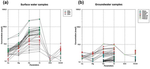
presents the results of hydrochemical analysis in two Schöeller diagrams. ) shows the hydrochemical characteristics of surface water samples from the study ponds. A sodium-chloride-type facies was predominant, particularly in the SOL water samples, which registered chloride concentrations of between 30 and 300 meq/L, making it a brackish-water-type pond. The SOP pond exhibited chloride concentrations in the range 10–20 meq/L; however, the ZAH pond was found to be a freshwater system (Cl−: 5–9 meq/L). ) shows the hydrochemical facies of the groundwater samples. The salinities of the groundwater samples were much lower than those of the surface water samples, varying from fresh to slightly brackish groundwater. The hydrochemical facies of the groundwater samples were of a mixed sodium-chloride type.
Figure 6. Schöeller diagrams of (a) surface water samples and (b) groundwater samples.
5 Discussion
In the proximity of the coastal resort, groundwater levels in the study piezometers declined more than 1 m. Custodio et al. (Citation2009) recognized that, in some areas, piezometric levels had been decreasing since 1970, reducing groundwater discharge to dependent ecosystems. This effect has probably been caused by both the introduction of berry crops in the surrounding area and an increase in population in nearby towns. More recently, Dimitriou et al. (Citation2017) showed the water level decline in four temporary ponds in the Doñana coastal aquifer using a hydrodynamic numerical model.
The results of the estimation of groundwater net fluxes in the ZAH, SOL and SOP ponds during two flooded periods suggest that both the SOL and SOP ponds act as discharge ponds, as, in both cases, there were water inputs from the aquifer to the ponds. In the SOL pond, this behaviour was already stated by Sacks et al. (Citation1992) and Lozano-Tomás (Citation2007). In the SOP pond, the proximity of the marshes at a lower altitude incites regional groundwater fluxes towards them. This pond overflows towards the marshes during heavy floods, similar to other sand dune ponds in the area (Serrano et al. Citation2008).
However, the ZAH pond behaves as a recharge pond (i.e. the opposite process occurs). In previous studies carried out by the authors (Fernández-Ayuso et al. Citation2018) in the same ponds, the GWNF in three months (summer 2016) was estimated. The values obtained for SOL, SOP and ZAH were 2.4, 1 and −0.9 mm/d, respectively. As stated by Serrano and Serrano (Citation1996), Serrano and Zunzunegui (Citation2008), Manzano et al. (Citation2009) and Dimitriou et al. (Citation2017), the hydrological behaviour of the ZAH pond has already been altered, and this alteration was most probably caused by groundwater pumping in the nearby coastal resort (more than 2.75 × 10⁶ m3/year) and the consequent depletion of the piezometric levels below the pond, inducing recharge.
Furthermore, an increase in evaporation rates is expected due to climate change, as reported by Guardiola-Albert and Jackson (Citation2011) and Scheffer et al. (Citation2015). These researchers also stated that the aquifer recharge produced by precipitation would be reduced. This would lead to a decrease in groundwater input towards the ponds and other dependent ecosystems.
The hydraulic gradient values measured between the SOL pond and nearby piezometers were positive towards the pond. No flux inversion occurred during the study period. This situation has been detected in other Spanish wetlands with similar anthropogenic pressures, such as Las Tablas de Daimiel National Park (Castaño et al. Citation2018, Aguilera et al. Citation2013). The parallels between these two significant Spanish wetlands, both highly dependent on groundwater resources in terms of conflicts in water management, were stated internationally for the first time by Llamas (Citation1988). Additionally, a progressive decay in groundwater levels due to water withdrawals is being observed in other protected wetlands in the Mediterranean region, resulting in deterioration in water quality and a loss of biodiversity (Green et al. Citation2017).
The stable hydroperiod in the SOL and SOP ponds and the reduction in flooded surface in the ZAH and Charco del Toro ponds can be observed in an application developed recently by the European Commission’s Joint Research Centre (Citation2016), Global Surface Water Explorer (https://global-surface-water.appspot.com/), which shows the extent and change of surface water bodies from 1984 to 2015.
A significant decreasing trend was clear in the PCHT1 and PCHT2 areas, whereas in piezometer PSOLE no significant decreasing trend could be observed. Comparing the rainfall trend over the same period, it is obvious that this sector of the aquifer is being affected by some reductions in the aquifer recharge, mainly due to the withdrawal of the nearby groundwater resources. Otherwise, the trend in PCHT1 and PCHT2 would be similar to the evolution of rainfall in terms of cumulated deviation from the mean over this same period.
Concerning hydrochemistry, the high salinity of the SOL pond can be explained by the hydrological functioning of the system: inputs are from groundwater and rainwater with low salinity (<0.2 g/L) and outputs are by evaporation, so the salts remain in the system, gradually increasing the salinity of the pond (Manzano et al. Citation2008). Furthermore, some of the SOL water inputs come from an adjacent pond, through local groundwater fluxes, which also contribute to its salt content. Salinity in the ZAH pond was much lower than in the other ponds, since water outputs were by evaporation, but also by infiltration from the pond towards the aquifer and, therefore, not all the salts remained in the pond. In view of the above, understanding the dynamic nature of groundwater–surface water interactions can be considered to facilitate the interpretation of hydrological and chemical relationships between the ponds and the groundwater (Sacks et al. Citation1992).
Taking all these facts into account, urgent action must be taken with regard to water management in the DNP, to preserve the remaining ponds not yet affected by local pressures.
6 Conclusions
This study has allowed us to improve existing knowledge of the hydrological functioning of three representative dune ponds located in the Doñana National Park, illustrating the scientific benefits of integrating both hydrological and hydrochemical tools in surface water–groundwater interaction studies. The groundwater hydrograms in piezometers not influenced by the pumping area in a nearby coastal resort showed a similar trend to the cumulative evolution of precipitation. However, those piezometers located near to the coastal resort showed a remarkably higher slope in this trend. The results from the water balances carried out between 2016 and 2018 show that the Santa Olalla (SOL) pond is strongly dependent on groundwater discharge from the aquifer; three-quarters of the water inputs come from such a source, with a median value of 2.3 mm/d. The main water output from the system was direct evaporation from the pond surface and small quantities of groundwater recharge during certain periods. The Sopeton (SOP) pond received median groundwater discharge of 1.8 mm/d, also behaving as a discharge pond. However, the Zahillo (ZAH) pond turned out to be a recharge pond; the median value of groundwater net flux was −0.1 mm/d for the period studied. The results of the water balance estimations and the decline in piezometric levels near Zahillo pond suggest that its proximity to the coastal resort has resulted in significant alterations to its hydrology.
The hydrochemistry results highlight the differences in hydrological regime between the ponds. Whereas the mean salinity of the water in the SOL and SOP ponds is of a brackish type, in the ZAH pond, the mean salinity is much lower. However, groundwater in the aquifer is freshwater and of a mixed sodium-chloride type. The hydrochemical facies of the surface water in the ponds is sodium chloride, indicating an intense evaporative mark in the hydrological functioning of the systems.
The outcomes of this study confirm that there is an alteration in the hydrology of the ZAH pond caused by groundwater withdrawal in nearby wells for urban supply. Moreover, the decreasing trend of the groundwater table in recent years, detected in the piezometers located between the pond and the pumping area, supports this idea. A former pond (Charco del Toro) near these piezometers dried out permanently in 2010. This situation has not yet been detected in Santa Olalla, although its proximity to the extraction area is a direct pressure that has to be monitored carefully in the near future to avoid an irreversible alteration in this permanent pond.
Apart from hydrological changes due to direct human pressure, those triggered by climatic change must also be considered, as these would create the need to adopt additional measures. Efforts to improve knowledge of the hydrological functioning of these ponds would seem to be crucial when it comes to encouraging the authorities and stakeholders take action to protect them. Furthermore, responsibility for their protection does not fall solely within Spanish boundaries, since Doñana is currently a World Heritage Site.
Acknowledgements
Support provided by Carmen Díaz-Paniagua (EBD-CSIC) in field activities and data correction has been crucial. The laboratory technician Jose Manuel Bruque Carmona (Pablo de Olavide University) helped in the elaboration of some of the figures. We are grateful to the Languages Service of Pablo de Olavide University and to the native speaker Christine Anne Pearce for the English corrections. We are thankful to the two anonymous reviewers for their valuable comments.
Disclosure statement
No potential conflict of interest was reported by the authors.
Additional information
Funding
References
- Aguilera, H., et al., 2013. Model of hydrological behaviour of the anthropized semiarid wetland of Las Tablas de Daimiel National Park (Spain) based on surface water–groundwater interactions. Hydrogeology Journal, 21 (3), 623–641. doi:10.1007/s10040-012-0950-3
- Castaño, S., et al., 2018. Long term effects of aquifer overdraft and recovery on groundwater quality in a Ramsar wetland: Las Tablas de Daimiel National Park, Spain. Hydrological Processes, 32 (18), 2863–2873. doi:10.1002/hyp.13225.
- Custodio, E., 2010. Intensive groundwater development: a water cycle transformation, a social revolution, a management challenge. In: Rethinking water and food security. Madrid: ROUTLEDGE in association with GSE Research, 259–277.
- Custodio, E., et al., 1992. Aportaciones al conocimiento hidrogeológico de los acuíferos del Parque Nacional de Doñana y su entorno. Hidrogeología y Recursos Hidráulicos, 16, 425–439.
- Custodio, E., Manzano, M., and Montes, C., 2009. Las aguas subterráneas en Doñana: aspectos ecológicos y sociales. Sevilla: Agencia de Medio Ambiente y Agua (Consejería de Medio Ambiente de la Junta de Andalucía).
- De Castro, F. and Muñoz-Reinoso, J.C., 1997. Model of long-term water-table dynamics at Doñana National Park. Water Research, 31 (10), 2586–2596. doi:10.1016/S0043-1354(97)00098-5
- Díaz-Paniagua, C. and Aragonés, D., 2015. Permanent and temporary ponds in Doñana National Park (SW Spain) are threatened by desiccation. Limnética, 34 (2), 407–424.
- Dimitriou, E., et al., 2017. Hydrodynamic numerical modelling of the water level decline in four temporary ponds of the Doñana National Park (SW Spain). Journal of Arid Environments, 147, 90–102. doi:10.1016/j.jaridenv.2017.09.004
- European Commission’s Joint Research Center, 2016. Visible body: global surface water change. Ispra, Italy. Available from: https://global-surface-water.appspot.com/ [ Accessed 15 June 2017].
- Fernández-Ayuso, A., Rodríguez-Rodríguez, M., and Benavente, J., 2018. Change in the hydrological functioning of Sand Dune Ponds in Doñana National Park (Southern Andalusia, Spain). In: M.L. Calvache, et al., eds. Groundwater and global change in the western mediterranean area, environmental earth sciences. Springer, 143–150. ISBN: 978-3-319-69356-9.
- Florencio, M. et al., 2009. Towards a quantitative classification of temporary ponds in Doñana (SW Spain). In: International conference on Mediterranean temporary ponds. Proceedings and Abstracts. Consell Insular de Menorca. Recerca 14. Menorca, 83–92.
- Geelen, L., Kamps, P., and Olsthoorn, T.N., 2017. From overexploitation to sustainable use, an overview of 160 years of water extraction in the Amsterdam dunes, the Netherlands. Journal of Coastal Conservation, 21 (5), 657–668. doi:10.1007/s11852-016-0452-x
- Green, A.J., et al., 2016. Doñana Wetlands (Spain). In: C. Finlayson, et al., eds. The wetland book: II: distribution, description and conservation. Dordrecht, NL: Springer, 1–14.
- Green, A.J., et al., 2017. Creating a safe operating space for wetlands in a changing climate. Frontiers in Ecology and the Environment, 15 (2), 99–107. doi:10.1002/fee.1459
- Guardiola-Albert, C. and Jackson, C.R., 2011. Potential impacts of climate change on groundwater supplies to the Doñana wetland, Spain. Wetlands, 31 (5), 907–920. doi:10.1007/s13157-011-0205-4
- Hayashi, M. and Van der Kamp, G., 2000. Simple equations to represent the volume–area–depth relations of shallow wetlands in small topographic depressions. Journal of Hydrology, 237 (1–2), 74–85. doi:10.1016/S0022-1694(00)00300-0
- Hollis, T., Heurteaux, P., and Mercer, J., 1989. Las consecuencias de la extracción de aguas subterráneas para el futuro a largo plazo del Parque Nacional de Doñana. IUCN: World Wildlife Fund/ADENA Mission to the Doñana National Park. 18–22 November 1988.
- IGME (Instituto Geológico y Minero de España), 2007. Revision de la informacion geofísica existente en el acuífero Almonte-Marismas (Doñana). Madrid: Spanish Geological Survey, Technical Report.
- Jaramillo, F., et al., 2018. Effects of hydroclimatic change and rehabilitation activities on salinity and mangroves in the Ciénaga Grande de Santa Marta, Colombia. Wetlands, 1–13. doi:10.1007/s13157-018-1024-7
- Junk, W.J., et al., 2013. Current state of knowledge regarding the world’s wetlands and their future under global climate change: a synthesis. Aquatic Sciences, 75 (1), 151–167. doi:10.1007/s00027-012-0278-z
- Kundzewicz, Z.W. and Doell, P., 2009. Will groundwater ease freshwater stress under climate change? Hydrological Sciences Journal, 54 (4), 665–675. doi:10.1623/hysj.54.4.665
- Llamas, M.R., 1988. Conflicts between wetland conservation and groundwater exploitation: two case histories in Spain. Environmental Geology, 11 (3), 241–251.
- Llamas, R., 2003. Lessons learnt from the impact of the neglected role of groundwater in Spain’s water policy. Developments in Water Science, 50, 63–81.
- Lozano-Tomás, E., 2007. Las aguas subterráneas en los cotos de Doñana y su influencia en las lagunas. Thesis (PhD). University Politécnica de Catalunya.
- Maltby, E. and Acreman, M.C., 2011. Ecosystem services of wetlands: pathfinder for a new paradigm. Hydrological Sciences Journal, 56 (8), 1341–1359. doi:10.1080/02626667.2011.631014
- Manzano, M., et al., 2008. Groundwater baseline composition and geochemical controls in the Doñana aquifer system (SW Spain). In: W.M. Edmunds and P. Shand, eds. Natural groundwater quality. Malden, MA: Blackwell, 216–232.
- Manzano, M., et al., 2009. Influencia de la gestión del acuífero sobre los humedales del manto eólico de Doñana. Boletín Geológico y Minero, 120, 377–392.
- McMahon, T.A., et al., 2013. Estimating actual, potential, reference crop and pan evaporation using standard meteorological data: a pragmatic synthesis. Hydrology and Earth System Sciences, 17 (4), 1331–1363. doi:10.5194/hess-17-1331-2013
- Meharg, A.A., et al., 1999. Contamination of Doñana food-chains after the Aznalcóllar mine disaster. Environmental Pollution, 105 (3), 387–390. doi:10.1016/S0269-7491(99)00033-0
- Muñoz-Reinoso, J.C., 2001. Vegetation changes and groundwater abstraction in SW Donana, Spain. Journal of Hydrology, 242 (3–4), 197–209. doi:10.1016/S0022-1694(00)00397-8
- Olías Alvarez, M. and Rodríguez Rodríguez, M., 2013. Evolución de los niveles en la red de control piezométrica del acuífero Almonte-Marismas (periodo 1994–2012). Hidrogeología y Recursos Hidráulicos (30): 1121–1130. Granada: Instituto Geológico y Minero de España. X Simposio de Hidrogeología. 16–18 October. ISBN (CD ROM): 978-84-7840-914-3.
- Olías, M., et al., 2008. Water qualitiy and distribution of trace elements in the Doñana aquifer (SW Spain). Environmental Geology, 55 (7), 1555–1568. doi:10.1007/s00254-007-1106-y
- Penman, H.L., 1956. Estimating evaporation. Eos, Transactions American Geophysical Union, 37 (1), 43–50. doi:10.1029/TR037i001p00043
- Rodríguez-Rodríguez, M., 2007. Hydrogeology of ponds, pools, and playa-lakes of southern Spain. Wetlands, 27 (4), 819–830. doi:10.1672/0277-5212(2007)27[819:HOPPAP]2.0.CO;2
- Rodríguez-Rodríguez, M., Fernández, A., and Moral, F., 2016. Hydrological regime and modeling of three ponds of the Mediterranean area (south of Córdoba, Spain). Hydrobiologia, 782 (1), 155–168. doi:10.1007/s10750-016-2820-9
- Sacks, L.A., et al., 1992. Seasonal dynamics of groundwater-lake interactions at Doñana National Park, Spain. Journal of Hydrology, 136 (1–4), 123–154. doi:10.1016/0022-1694(92)90008-J
- Sakho, I., et al., 2011. The influence of natural and anthropogenic factors on mangrove dynamics over 60 years: the Somone estuary, Senegal. Estuarine, Coastal and Shelf Science, 94, 93–101. doi:10.1016/j.ecss.2011.05.032
- Scheffer, M., et al., 2015. Creating a safe operating space for iconic ecosystems. Science, 347 (6228), 1317–1319. doi:10.1126/science.aaa3769
- Serrano, L., Esquivias-Segura, M.P., and Zunzunegui, M., 2008. Long-term hydrological changes over a seventeen-year period in temporary ponds of the Doñana NP (SW Spain). Limnetica, 27 (1), 065–78.
- Serrano, L. and Serrano, L., 1996. Influence of groundwater exploitation for urban water supply on temporary ponds from the Doñana National Park (SW Spain). Journal of Environmental Management, 46 (3), 229–238. doi:10.1006/jema.1996.0018
- Serrano, L. and Zunzunegui, M., 2008. The relevance of preserving temporary ponds during drought: hydrological and vegetation changes over a 16-year period in the Doñana National Park (southwest Spain). Aquatic Conservation: Marine and Freshwater Ecosystems, 18 (3), 261–279. doi:10.1002/(ISSN)1099-0755
- Suso, J. and Llamas, M.R., 1993. Influence of groundwater development on the Doñana National Park ecosystems (Spain). Journal of Hydrology, 141 (1–4), 239–269. doi:10.1016/0022-1694(93)90052-B
- UNESCO (United Nations Educational, Scientific and Cultural Organization), 2017. Concerning the protection of the world cultural and natural heritage world heritage committee. Decisions adopted during the 41st session WHC/17/41.COM/18, p. 85 of the World Heritage Committee Decision. Poland: Forty-first session Krakow.
- Vela, A., 1984. Estudio preliminar de la hidrogeología e hidrogeoquímica del sistema de dunas móviles y flecha litoral del Parque Nacional de Doñana. Master Thesis. Faculty of Geological Sciences. University Complutense Madrid.