
ABSTRACT
A consolidated geomorphology-based approach for discharge prediction in ungauged basins (PUB) through deconvolution of discharge signals from gauged donor catchments, their transposition and their convolution towards target outlets, has been made available online to end users through a Web Processing Service (WPS) for the synoptic peninsular region of Brittany, France. In the spirit of hydrological services, the SIMFEN WPS allows anyone to execute the hydrological modelling package transfR online through: (1) Open Geospatial Consortium (OGC®) interoperability standards; (2) collection and use of public hydrometric data; (3) connection to the pre-existing MNTSurf WPS for geomorphometric analysis; (4) visualization using a collaboratively developed Mviewer; and (5) innovative WPS workflows. The ability to model discharge series at any ungauged outlet of the synoptic region is offered to specialists of other disciplines, non-modeller water practitioners and interested citizens to support interdisciplinarity, water monitoring and management, and related science-society-policy debates and actions.
Editor A. Castellarin Guest editor H. Lins
Introduction
According to the World Meteorological Organization (WMO Citation2015),
hydrological services consist of the provision of information and advice on the past, present and future state of rivers, lakes and other inland waters including streamflow, river and lake levels and water quality. These services focus mainly on the surface component of the hydrological cycle […]. They also include information on subsurface (underground) water resources.
To do so, they use, produce and add value to data, statistical products, projections, scenarios, models, model outputs, forecasts, warnings, analyses and maps, and provide the information in a user-friendly and meaningful format. Their added value resides at the science-society-policy/operation interface, as they provide hydrological information in a way that assists monitoring and decision-making by individuals and organizations (WMO Citation2018a, Citation2018b), consistent with the wider Global Framework for Climate Services (GFCS; WMO Citation2010, Citation2014).
The information and decision-making refer to a wide range of the following:
hydrological processes;
related and interconnected processes, such as dynamics and co-evolutions of socio-hydrology and the water–energy–food nexus (Liu et al. Citation2017, Cudennec et al. Citation2018, Di Baldassarre et al. Citation2019, Connor et al. Citation2020);
related time scales, from real-time crisis mitigation (itself spanning orders of magnitude depending on the characteristic times of the events and systems considered) to long-term management of trends and changes (Montanari et al. Citation2013, Ceola et al. Citation2016, McMillan et al. Citation2016, Fovet et al. Citation2018); and
related spatial scales and organization levels (Blöschl and Sivapalan Citation1995, Brondizio et al. Citation2016).
These considerations relate to major challenges in hydrology (see unsolved problems in hydrology (UPH); Blöschl et al. Citation2019) along the value chain from monitoring and data management (Pecora and Lins Citation2020; Dixon et al. Citation2020), conceptualizing and modelling, to delivering to end users with communication of uncertainties (see UPH #21). Besides specialists and professionals, this also strongly relates to increasing societal awareness of hydrological status and citizen involvement in related efforts – from citizen science to enlightened contributions to controversies, foresight options and strategic choices (Wehn et al. Citation2015, Bai et al. Citation2016, Nardi et al. Citationaccepted).
Streamflow discharge series are essential hydrological information that underlies all hydrological signatures and is relevant for decision-making; however, it is often not available for the exact location(s) for which decisions need to be made. Major methodological progress has been achieved over the past several years in prediction in ungauged basins (PUB) (Blöschl et al. Citation2013, Hrachowitz et al. Citation2013, Pomeroy et al. Citation2013). Dissemination and operationalization of some of these methods are advancing in specialized institutions due to dedicated education and training programmes. Nevertheless, developing PUB-related hydrological services remains a challenge that would increase the availability of outputs of such methods relevant to end users, at their targeted location(s) of interest, capitalizing on the available raw data and curating the methodological (often modelling) aspects – and thus the associated uncertainties – for non-specialists.
This article presents the development of the interoperable and open-access Web Service SIMFEN (Service Interopérable de Modélisation des Flux d’Eau Non-influencés in French, i.e. Interoperable service for modelling non-influenced water flows), which provides a consolidated, robust and flexible PUB modelling method to end users. The method allows users to simulate series of streamflow discharge (i.e. hydrograph) at the outlet of a given ungauged target basin based on series of discharge observed at the outlet(s) of one or more information-donor basins using a geomorphology-based deconvolution-transposition-reconvolution approach. The SIMFEN Web Processing Service (WPS) and associated interface allow end users to simulate discharge series online at any location of the river network draining at least approx. 10 km2 of the synoptic region of Brittany (Bretagne in French), France, which has a coherent hydrographic area of 29,640 km2 and faces serious hydrological (including hydrochemical) issues (Cudennec et al. Citation2015, Fovet et al. Citation2018, de Lavenne et al. Citation2019). The hydrometric data required by the WPS are automatically downloaded from public databases to simplify use by end users. Advanced options are offered for exploring modelling variations and thus the principles, characteristics, accuracy and uncertainties of the approach. The simulated streamflow discharge series is displayed graphically in the web interface and made available via optional download or a WPS workflow to assure full compatibility and ease of use. This article presents the hydrological modelling approach and the rationale of WPSs before describing the combination of both in the SIMFEN Web Service and the latter’s hydroinformatic and ergonomic characteristics.
Methods and synoptic data
Geomorphology-based hydrological modelling by transposing discharge series
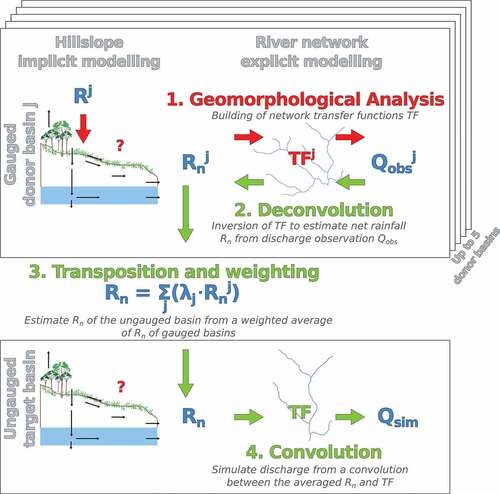
In line with the geomorphology-based unit hydrograph approach (initiated by Dooge Citation1959, Surkan Citation1969 – see Rigon et al. Citation2016 for perspectives), and more specifically the family based on geomorphometric functions of a basin’s river network – rather than that based on the Strahler branching topological cascade (Rodríguez-Iturbe and Valdés Citation1979, Cudennec et al. Citation2004, Cudennec Citation2007), our approach considers a basin-level hydrological transfer function (TF) deduced from the geomorphometry-based observable probability density function of hydraulic lengths across the relief and river network (Cudennec et al. Citation2004, Citation2005, Cudennec and Fouad Citation2006, Aouissi et al. Citation2013) and an assumed average streamflow velocity. The latter linear assumption is a common way to simplify variability and dispersion (Rinaldo et al. Citation1991) to make predictions of little-known or ungauged basins more robust (Snell and Sivapalan Citation1994, Robinson et al. Citation1995, Moussa Citation1997).
In line with the unit hydrograph approach, for a given basin, convoluting its TF with an estimate of its basin-averaged net rainfall series (Rn) allows streamflow discharge (Q) at its outlet to be simulated. Consistent with the definition of the geomorphology-based TF, by accounting for transfer across the river network, Rn is the basin-averaged water flow signal that is produced by hillslopes and that enters the river network (Cudennec Citation2000, Boudhraâ et al. Citation2009). Although the geomorphology-based approach is generic, estimating Rn depends on highly heterogeneous and contingent hillslope hydrology (Fan et al. Citation2019), which limits simulation in ungauged basins. The following alternative approach was thus developed.
For a given gauged basin j, characterized by its linear geomorphology-based transfer function (TFj), inverting TFj allows Rnj to be estimated by deconvoluting the series of observed discharge at the outlet (Qobsj) (Cudennec Citation2000, Boudhraâ et al. Citation2018) (). Transposing Rnj from the gauged basin j (i.e. donor basin j) to the target basin and then convoluting with the transfer function of the target basin (TF) allows the discharge series at the target outlet (Qsim) to be simulated. The TF can be estimated for an ungauged target basin through geomorphometric observation of its relief and river network, as mentioned, and a robust estimate of its streamflow velocity. In addition to this paired approach with a single donor basin, a weighted combination of several donor basins can be considered in a kind of multi-basin ensemble modelling (McIntyre et al. Citation2005, Randrianasolo et al. Citation2011), with weights λ based on the inverse of the Ghosh distances between basins (de Lavenne et al. Citation2016) (). Identifying candidate donor basin(s) depends on hydrological similarity (Blöschl et al. Citation2013, Hrachowitz et al. Citation2013) and was considered in our approach by using nesting and neighbouring basin configurations as a robust framework for operationalization.
Figure 1. Principles of geomorphology-based hydrological modelling.
This approach has been applied to three contexts: small basins of the Dorsale mountain ridge in semi-arid Tunisia (Nasri et al. Citation2004, Boudhraâ et al. Citation2006, Citation2009, Citation2018), the neighbouring Brittany peninsula and Loire River basin in temperate oceanic France (de Lavenne et al. Citation2015, Citation2016) and a large region north of the Saint Lawrence River in pluvio-nival Québec, Canada (Ecrepont et al. Citation2019). Regional estimates of basin-averaged streamflow velocity were developed by de Lavenne (Citation2013), de Lavenne et al. (Citation2016) and Ecrepont et al. (Citation2019) for the synoptic domains of the Brittany peninsula, the Loire River basin and the Québec region, respectively. When compared to top-kriging (Skoien and Blöschl, Citation2007), the approach showed results of similar quality (de Lavenne et al. Citation2016). The robustness of the approach to hydrometric configurations has been shown through sensitivity analysis and leave-one-out pseudo-ungauged tests (de Lavenne et al. Citation2015, 2016, Boudhraâ et al. Citation2018, Ecrepont et al. Citation2019). Robustness to the resolution of the digital elevation model (DEM) used to characterize the geomorphometry has also been shown for Brittany (Ecrepont and Cudennec Citation2020). In addition, in the spirit of PUB, truly ungauged basins have been simulated between paired donor–target basins (de Lavenne and Cudennec Citation2014) and via ensemble modelling of multiple donor basins (de Lavenne and Cudennec Citation2019). In terms of hydroinformatics, scripts for this approach have been developed in a dedicated package (transfR) for R software (R Core Team Citation2017).
Principles of a Web Service
A Web Service is a set of applications located on servers that can be accessed through the internet via standard protocols for machine-to-machine interaction. These standard protocols have been established by the Open Geospatial Consortium (OGC) and approved by the World Wide Web Consortium (W3 C). They are composed of the Web Services Description Language (WSDL), the Simple Object Access Protocol (SOAP) for information exchange, and Universal Description, Discovery and Integration (UDDI) for registration (Curbera et al. Citation2002, Chinnici et al. Citation2007, Mitra and Lafon Citation2007). Requests to Web Services are conveyed over the internet by HTTP protocol.
A Web Service facilitates data access (Goodall et al. Citation2008, Kadlec and Ames Citation2011) by using standard protocols for inputs and outputs, such as WaterML for temporal data (Taylor Citation2011) and Geography Markup Language (GML) for spatial data (Portele Citation2007). A Web Service can be used as a stand-alone application or integrated into a workflow (Granell et al. Citation2010, Castronova et al. Citation2013, Goodall et al. Citation2013, Turuncoglu et al. Citation2013) because of its interoperability (Kadlec and Ames Citation2011). Moreover, using a Web Service to collect data improves the use of the data and limits duplication and redundant maintenance (Goodall et al. Citation2008, Béra et al. Citation2015).
Connecting a Web Service to a web interface and Spatial Data Infrastructure also allows for the development of data processing, analysis, modelling and visualization functions (Granell et al. Citation2010, Béra et al. Citation2015, Rosatti et al. Citation2018) and, thus, for development of Web Processing Services (WPS), in addition to Web Feature Services (WFS) of the data flux type. The WPS approach can facilitate the performance of hardware architecture (operating system), use of programming languages, and execution of models. The underlying OGC® WPS standard (Whiteside Citation2007) was initially developed for geospatial processing, but its specifications for data encapsulation and communication between client and server allow it to be used for modelling, linking scripts and automatic updates.
Hydrogeomorphological and hydrometric data of Brittany
The regional reference DEM and associated river network embedded in the SIMFEN WPS was obtained by correcting the 50-m resolution DEM provided by the French Geographical Institute (IGN) of its drainage anomalies with MNTSurf software, itself provided as a WPS (Aurousseau and Squividant Citation1996, Squividant et al. Citation2015).
River gauging stations are managed by DREAL (Direction Régionale de l’Environnement, de l’Aménagement et du Logement), the regional division of the French Ministry in charge of the Environment. There are 125 stations available in the region, the oldest one dating back to 1938. Hydrometric data and some signatures are contained in the national Banque Hydro websiteFootnote1 but are currently difficult for end users to access and download. However, DREAL has an OGC-compliant data flux WFS of daily discharges,Footnote2 which to date has remained for confidential use by a regional consortium for inter-agency coordination (GéoBretagneFootnote3) to monitor the regional hydrological status and display it in summaries (e.g. https://bretagne-environnement.fr). The SIMFEN WPS uses the DREAL database and data flux WFS to update inputs and – consistent with the principles of Web Service interoperability and reusability, and the INSPIRE directive (EC Citation2018) – will be easily switched to the complete public hydrometric data flux Web Service once it is made available at the national level.
Development of the SIMFEN hydrological Web Service
System and architecture
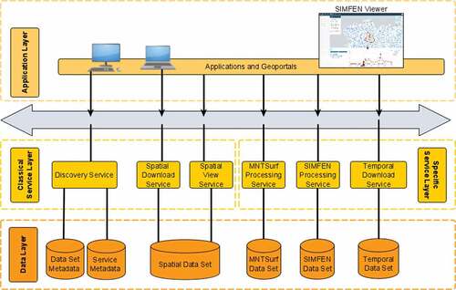
The system is organized into four parts: client, calculation, data and web servers (); and development followed the INSPIRE-directive architecture, which is organized into three layers: service, data and application (). The service layer is the core of the SIMFEN WPS service-oriented architecture, which has two types of service functions. First, classical and well-known functions, which are used in many other Spatial Data Infrastructures, are discovery, spatial view and spatial download functions, to find, view and download geographical data, respectively. Second, more specific functions are (i) a temporal download function, to share hydrological series; (ii) connection to the pre-existing MNTSurf WPS, which includes geomorphometric functions; and (iii) the SIMFEN WPS itself, which executes the hydrological modelling functions using the transfR package. The data layer describes persistent data storage associated with each service, using different types. For example, the temporal function is associated with a PostgreSQL database, MNTSurf WPS with a simple “directories and files” data organization and the spatial download function with both a PostGIS database and raster GeoTIFF files or vector shapefiles. The application layer connects end users to the functions and services of the service layer. All of the latter developments can be reused by any OGC-compliant application.
Figure 2. Informatics system supporting the SIMFEN Web Service.
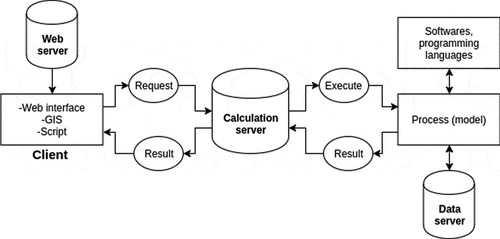
Figure 3. INSPIRE-type architecture of the SIMFEN Web Service.
The SIMFEN WPS can be accessed directly using a GIS software, a script or URL request at http://wps.geosas.fr/simfen. For ease of use by non-specialist end users, however, we developed a public web interface (http://bit.do/simfen).
Description of the SIMFEN WPS
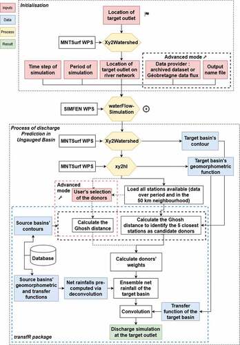
To make it easy to use, the SIMFEN WPS allows users to execute the transfR package, with a minimum of input data (). It is operationalized through a process developed with PyWPS (version 4.3.dev0), which is an implementation of the OGC® WPS standard written in Python (Čepický and De Sousa Citation2016) that supports WPS version 1.0.0. Modelling results follow the OGC® WaterML standard (Kadlec and Ames Citation2011) and, for those using the web interface, are provided in.csv format.
Figure 4. Hydroinformatics flowchart of the SIMFEN Web Service.
Web application and interface
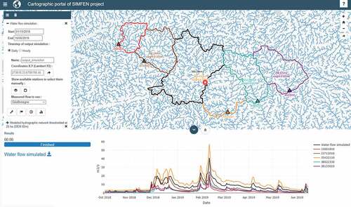
The web application and bilingual interface () on the web server are based on the cartographic viewer “MViewer” collaboratively developed by the GéoBretagne consortium,Footnote4 to which we have contributed for several years as a research unit committed to providing open results and products to the public. It was developed using HTML5, CSS3, JavaScript, JQuery, OpenLayers and BootStrap. An add-on has been developed to send a form to the SIMFEN WPS with user inputs, to track progression and to collect modelling results.
Figure 5. Web interface of the SIMFEN Web Service illustrated with a discharge simulation for an ungauged target outlet based on five donor basins.
Pre-treatments and processing time
The hydrological modelling is composed of three steps: deconvolution of observed discharge series of the donor basin(s), transposition using ensemble weighting towards the target basin and simulation of discharge at the target outlet via convolution (). The last two steps depend upon user choices at execution, but the deconvolution step is pre-computed (). It estimates the Rn of a gauged basin as a function of the latter’s contour, geomorphometric function and the entire history of streamflow discharge series at the outlet. These characteristics are calculated in advance for every gauged basin (i.e. potential donor basin) in the domain and stored in the PostgreSQL database on the data server. Thus, deconvolution, which requires the most time because of its underlying inverse modelling, does not need to be performed at the time of simulation, increasing the speed of service delivery. The Rn is updated automatically every week by a script that determines whether new discharge measurements are available from the data flux WFS.
In addition, processing time has been optimized by using the OGC® WPS, which allows processes to be executed asynchronously. During the execution of the modelling functions, the WPS returns an iterative XML document with a tag status. The web interface controls this tag to know when the process has finished, allowing users to view and optionally download the results.
Operational use sequence and options
The web interface displays a default configuration to allow anyone to run the SIMFEN WPS, with standard options. The advanced mode, which allows users to customize certain options, is useful for those who wish to use their hydrological expertise in the modelling exercise or to explore alternate options and assess the sensitivity and quality of simulations. This feature, visualization options, accompanying documentation and metadata aim to help end users understand the modelling principles, epistemology, data-dependence and uncertainties. Online documentation includes the rationale, scientific references, credits and disclaimers. A tutorial video is also available.Footnote5 The entire interface has been tested and finely tuned with a focus group of end users.
To proceed, the user indicates the location of the target outlet and the period over which to simulate streamflow discharge series (i.e. the hydrograph) (). Consistency of these inputs with the temporal and spatial data available is verified. In the web interface, the user indicates the target outlet by placing a flag symbol on the map of the reference river network in a map window (default mode) or by entering geographic coordinates (RGF93-Lambert 93 coordinate system, EPSG:2154) in a numeric window (advanced mode). Related cartographic data are provided in the web interface to help users locate points of interest and target outlets, and to provide information for interpreting the modelling results. These data, not used by the model, are visualized in the MViewer. The data currently provided are locations of public hydrometric and quality monitoring stations; administrative boundaries of hydrographic regions, reporting sectors and water management plans; and boundaries of hydrogeological entities and potential wetlands. These data are available using WFSs, essentially of the national public service SANDRE,Footnote6 and they are displayed in the SIMFEN web interface ( provides an illustration) using an on-demand workflow, with no data storage in the SIMFEN database and thus no updating or maintenance issues.
The “xy2watershed” function of MNTSurf WPS (Squividant et al. Citation2015) is used to precisely locate the target outlet on the river network and delineate the contour of the target basin. Then, the “xy2hl” function of MNTSurf WPS analyses the river network within the target basin to extract the geomorphometric function, which then yields the TF when the regional streamflow velocity is applied ().
Next, the process builds a WFS request to identify all gauging stations available in the DREAL database in the geographic neighbourhood of the target basin over the given period. Up to five of the closest gauged basins in terms of Ghosh distance with the target basin are identified within a radius of 50 km and proposed for ensemble modelling in the default mode. In the advanced mode, users can adjust the set of donor basins based on their knowledge of hydrological similarity with the target basin by selecting basins on the map of all available gauging stations ().
Then, users execute the transfR modelling package, using a dedicated button, which simulates streamflow discharge series, at the ungauged target outlet. Using the button is a cognitive engagement for the end user in the modelling exercise. The simulated hydrograph is displayed in the interface and downloadable in .csv format or via a WPS request. Users can also display observed hydrographs of the source basins on top of the simulated hydrograph, which provides a visual comparison of the simulated hydrograph to the envelope of the observed data series used as a source of hydrometric information in the paired or ensemble modelling approach ( displays the example of an enveloped simulation for a target basin based on five donor basins). The combined display of the hydrographs and mapping of the basin contours and networks help users understand the basins’ hydrological behaviour, hydrological similarity, as well as the modelling epistemology, data-dependence and uncertainties. They also allow advanced users to explore options and gain expertise.
The simulated hydrographs are accompanied by the processing metadata, which include the location of the target outlet, the period simulated and the basin(s) used as a source of information. The metadata allow users of the SIMFEN WPS and those with whom simulations are subsequently shared to replicate the simulations and understand the data. In addition, following the WPS standard, a function (GetCapabilities request) allows users to access the Web Service metadata themselves.
Conclusion
Web Service technology and interoperability standards were used to develop a hydrological service that provides a consolidated geomorphology-based modelling approach online to simulate streamflow discharge series (hydrographs) at ungauged target outlets of societal or technical interest. The SIMFEN Web Service allows anyone to execute the hydrological modelling package transfR online using a dedicated WPSFootnote7 with the following rationale: (1) respect of OGC interoperability standards; (2) collection and use of public hydrometric and hydrogeomorphological data; (3) connection to the pre-existing MNTSurf WPS for geomorphometric analysis; (4) visualization through a web interface using a collaborative MViewerFootnote8; and (5) facilitation of future innovative WPS workflows.
The SIMFEN WPS is currently available for the synoptic peninsular region of Brittany, France. It benefits from the combination of a consolidated geomorphology-based hydrological modelling approach and a proactive collaborative strategy for open access to research data and products of the research unit SAS. Its ergonomics and options have been designed in cooperation with a focus group of end users. The Web Service is tuned to current data flux WFSs offered by the regional public hydrometric authorities and is switchable to upcoming national WFS data fluxes, which will allow expanding the geographic domain and may open up new opportunities, especially as the data will have hydrometric time steps shorter than one day. The SIMFEN Web Service provides modelling abilities to end users, such as specialists of other disciplines interfacing with hydrology, non-modeller water practitioners and interested citizens. It supports interdisciplinarity, water monitoring and management, as well as related science-society-policy debates and actions (Cudennec et al., Citation2020). Along with the modelling results, the ergonomic standards and advanced options of the web interface provide information and visualizations that can further support the cognitive progress and capacity building of individuals and institutions. This support can increase awareness of, understanding of and expertise in hydrological behaviour and similarity, as well as of modelling methodology, data-dependency, and uncertainties. In the spirit of hydrological services, the facilitated modelling can also be used to support targeted analyses, debates and decisions, and to make responsibilities explicit when using data and simulations. The service has been developed in the French region of Brittany and is ready to be switched to the whole of France when the announced complete national public hydrometric data flux Web Service is made available by the Ministry in charge. It can further be considered as a proof of concept to be generalized in many regions of the world.
Acknowledgements
The feedback provided by end users involved in the focus group is greatly acknowledged.
Disclosure statement
No potential conflict of interest was reported by the authors.
Additional information
Funding
Notes
References
- Aouissi, J., et al., 2013. Joint spatial, topological and scaling analysis of river network geomorphometry. Géomorphologie – Relief Processus Environnement, 19 (1), 7–16. doi:10.4000/geomorphologie.10082
- Aurousseau, P. and Squividant, H., 1996. Use of tree and graph structures for computation and modelling of derived variables in digital elevation model software. Available from: http://viviane.roazhon.inra.fr/spanum/publica/ing_vie/dem2.htm [Accessed 26 Oct 2020].
- Bai, X., et al., 2016. Plausible and desirable futures in the anthropocene: a new research agenda. Global Environmental Change, 39, 351–362. doi:10.1016/j.gloenvcha.2015.09.017
- Béra, R., et al., 2015. GéoSAS: a modular and interoperable open source spatial data infrastructure for research. PIAHS, 368, 9–14. doi:10.5194/piahs-368-9-2015
- Blöschl, G., et al., 2013. Runoff prediction in ungauged basins: synthesis across processes, places and scales. Cambridge, UK: Cambridge University Press.
- Blöschl, G., et al., 2019. Twenty-three unsolved problems in hydrology (UPH) – a community perspective. Hydrological Sciences Journal, 64 (10), 1141–1158. doi:10.1080/02626667.2019.1620507
- Blöschl, G. and Sivapalan, M., 1995. Scale issues in hydrological modelling: a review. Hydrological Processes, 9 (3–4), 251–290.
- Boudhraâ, H., et al., 2006. Inversion d’une modélisation de type hydrogramme unitaire à base géomorphologique: interprétation physique et première mise en œuvre. In: M. Sivapalan, et al., ed. Predictions in ungauged basins: promises and progress. Wallingford, UK: International Association of Hydrological Sciences, IAHS Publ, 303, 391–399. Available from: https://iahs.info/uploads/dms/13451.48-391-399-S7-52-Boudhraa-et-al.pdf [Accessed 13 July 2020].
- Boudhraâ, H., et al., 2009. Hydrograph transposition between basins through a geomorphology-based deconvolution–reconvolution approach. In: K.K. Yilmaz, et al., ed. New approaches to hydrological prediction in data-sparse regions. Wallingford, UK: International Association of Hydrological Sciences, IAHS Publ, 333, 76–83. Available from: https://iahs.info/uploads/dms/14818.14-76-83-333-30-4175_Boudhraaetal-corr.pdf [Accessed 13 July 2020].
- Boudhraâ, H., et al., 2018. Net rainfall estimation by the inversion of a geomorphology-based transfer function and discharge deconvolution. Hydrological Sciences Journal, 63 (2), 285–301. doi:10.1080/02626667.2018.1425801
- Brondizio, E.S., et al., 2016. Re-conceptualizing the anthropocene: a call for collaboration. Global Environmental Change, 39, 318–327. doi:10.1016/j.gloenvcha.2016.02.006
- Castronova, A.M., Goodall, J.L., and Elag, M.M., 2013. Models as web services using the Open Geospatial Consortium (OGC) Web Processing Service (WPS) standard. Environmental Modelling and Software, 41, 72–83. doi:10.1016/j.envsoft.2012.11.010
- Ceola, S., et al., 2016. Adaptation of water resources systems to changing society and environment: a statement by the international association of hydrological sciences. Hydrological Sciences Journal, 61 (16), 2803–2817. doi:10.1080/02626667.2016.1230674
- Čepický, J. and De Sousa, L.M., 2016. New implementation of OGC Web Processing Service in Python programming language. PyWPS-4 and issues we are facing with processing of large raster data using OGC WPS. The International archives of the photogrammetry, remote sensing and spatial information sciences, XLI-B7, 927–930. doi:10.5194/isprsarchives-XLI-B7-927-2016
- Chinnici, R., et al., eds., 2007. Web Services Description Language (WSDL) Version 2.0 Part 1: core Language. W3C recommendation. W3C – World Wide Web Consortium. https://www.w3.org/TR/2007/REC-wsdl20-20070626 [Accessed 26 Oct 2020].
- Connor, R., et al., 2020. Chapter 9 – Water-climate-energy-food-environment Nexus. In The United Nations World Water Development Report 2020 ‘Water and Climate Change’. ISBN 978-92-3-100371-4, 118–125. Available from: https://en.unesco.org/themes/water-security/wwap/wwdr/2020
- Cudennec, C., 2000. Description mathématique de l’organisation du réseau hydrographique et modélisation hydrologique. PhD Thesis. Ecole Nationale Supérieure Agronomique de Rennes.
- Cudennec, C., et al., 2004. A geomorphological explanation of the unit hydrograph concept. Hydrological Processes, 18 (4), 603–621. doi:10.1002/hyp.1368
- Cudennec, C., 2007. On width function-based unit hydrographs deduced from separately random self-similar river networks and rainfall variability. Hydrological Sciences Journal, 52 (1), 230–237. doi:10.1623/hysj.52.1.230
- Cudennec, C., Gascuel-Odoux, C., and Ruiz, L., 2015. Bilan et perspectives. In: C. Gascuel Odoux and L. Ruiz, eds. Comment réconcilier agriculture et littoral? Vers une agroécologie des territoires. Editions Quae, Matière à débattre, 137–141. Available from: https://www.quae.com/produit/1285/9782759222865/comment-reconcilier-agriculture-et-littoral
- Cudennec, C., et al., 2018. Epistemological dimensions of the water–energy–food nexus approach. Hydrological Sciences Journal, 63 (12), 1868–1871. doi:10.1080/02626667.2018.1545097
- Cudennec, C., et al., 2020. Towards FAIR and SQUARE hydrological data. Hydrological Sciences Journal, 65 (5), 681–682. doi:10.1080/02626667.2020.1739397
- Cudennec, C. and Fouad, Y., 2006. Structural patterns in river network organization at both infra- and supra-basin levels: the case of a granitic relief. Earth Surface Processes and Landforms, 31 (3), 369–381. doi:10.1002/esp.1275
- Cudennec, C., Slimani, M., and Le Goulven, P., 2005. Accounting for sparsely observed rainfall space-time variability in a rainfall-runoff model of a semiarid Tunisian basin. Hydrological Sciences Journal, 50 (4), 617–630. doi:10.1623/hysj.2005.50.4.617
- Curbera, F., et al., 2002. Unraveling the Web services Web: an introduction to SOAP, WSDL, and UDDI. IEEE Internet Computing, 6 (2), 86–93.
- de Lavenne, A., 2013. Modélisation hydrologique à base géomorphologique de bassins versants non jaugés par régionalisation et transposition d’hydrogramme. Ph.D thesis. Agrocampus Ouest Rennes. Available from: https://prodinra.inra.fr/record/258610.
- de Lavenne, A., et al., 2016. Transferring measured discharge time series: large-scale comparison of Top-kriging to geomorphology-based inverse modeling. Water Resources Research, 52 (7), 5555–5576. doi:10.1002/2016WR018716
- de Lavenne, A., Boudhraâ, H., and Cudennec, C., 2015. Streamflow prediction in ungauged basins through geomorphology-based hydrograph transposition. Hydrology Research, 46 (2), 291–302. doi:10.2166/nh.2013.099
- de Lavenne, A. and Cudennec, C., 2014. Prediction of streamflow from the set of basins flowing into a coastal bay. IAHS Publ, 365, 55–60. doi:10.5194/piahs-365-55-2015
- de Lavenne, A. and Cudennec, C., 2019. Assessment of freshwater discharge into a coastal bay through multi-basin ensemble hydrological modelling. Science of the Total Environment, 669, 812–820. doi:10.1016/j.scitotenv.2019.02.387
- Di Baldassarre, G., et al., 2019. Sociohydrology: scientific challenges in addressing the sustainable development goals. Water Resources Research, 2018WR023901. doi:10.1029/2018WR023901
- Dixon, H., et al., 2020. Intergovernmental cooperation for hydrometry – what, why, how? Hydrological Sciences Journal. doi:10.1080/02626667.2020.1764569
- Dooge, J.C.I., 1959. A general theory of the unit hydrograph. Journal of Geophysical Research, 64 (2), 241–256.
- EC (European Commission). 2018. INSPIRE - an efficient way to share European spatial data!, 1066897. https://inspire.ec.europa.eu/documents/inspire-efficient-way-share-european-spatial-data [Accessed 3 August 2020].
- Ecrepont, S., et al., 2019. PUB in Québec: A robust geomorphology-based deconvolution-reconvolution framework for the spatial transposition of hydrographs. Journal of Hydrology, 570, 378–392. doi:10.1016/j.jhydrol.2018.12.052
- Ecrepont, S. and Cudennec, C., 2020. Geomorphometry-based modelling of discharge series in ungauged basins – robustness regarding DEM sources. PIAHS, 383, 129–134. doi:10.5194/piahs-383-129-2020
- Fan, Y., et al., 2019. Hillslope hydrology in global change research and Earth system modeling. Water Resources Research, 55, 1737–1772. doi:10.1029/2018WR023903
- Fovet, O., et al., 2018. AgrHyS: an observatory of response times in agrohydro systems. Vadose Zone Journal : VZJ, 17:180066. doi:10.2136/vzj2018.04.0066
- Goodall, J.L., et al., 2008. A first approach to web services for the national water information system. Environmental Modelling and Software, 23 (4), 404–411. doi:10.1016/j.envsoft.2007.01.005
- Goodall, J.L., et al., 2013. Coupling climate and hydrological models: interoperability through Web Services. Environmental Modelling and Software, 46, 250–259. doi:10.1016/j.envsoft.2013.03.019
- Granell, C., Díaz, L., and Gould, M., 2010. Service-oriented applications for environmental models: reusable geospatial services. Environmental Modelling and Software, 25 (2), 182–198. doi:10.1016/j.envsoft.2009.08.005
- Hrachowitz, M., et al., 2013. A decade of Predictions in Ungauged Basins (PUB) – a review. Hydrological Sciences Journal, 58 (6), 1198–1255. doi:10.1080/02626667.2013.803183
- Kadlec, J. and Ames, D.P., 2011. Design and development of web services for accessing free hydrological data from the Czech Republic. In: International symposium on environmental software systems (2011). Berlin: Springer, 581–588.
- Liu, J., et al., 2017. Challenges in operationalizing the water energy-food nexus. Hydrological Sciences Journal, 62 (11), 1714–1720. doi:10.1080/02626667.2017.1353695
- McIntyre, N., et al., 2005. Ensemble predictions of runoff in ungauged catchments. Water Resources Research, 41 (12), W12434. doi:10.1029/2005WR004289
- McMillan, H., et al., 2016. Panta Rhei 2013-2015: global perspectives on hydrology, society and change. Hydrological Sciences Journal, 61 (7), 1174–1191. doi:10.1080/02626667.2016.1159308
- Mitra, N. and Lafon, Y., 2007. SOAP version 1.2 Part 0: primer. 2nd ed. W3C recommendation. W3C – World Wide Web Consortium.
- Montanari, A., et al., 2013. “Panta Rhei – everything flows”: change in hydrology and society – the IAHS Scientific Decade 2013–2022. Hydrological Sciences Journal, 58 (6), 1256–1275. doi:10.1080/02626667.2013.809088
- Moussa, R., 1997. Geomorphological transfer function calculated from digital elevation models for distributed hydrological modelling. Hydrological Processes, 11 (5), 429–449. doi:10.1002/(SICI)1099-1085(199704)11:5≤429::AID-HYP471≥3.0.CO;2-J
- Nardi, F., et al., accepted. Citizens AND HYdrology (CANDHY): conceptualizing a transdisciplinary framework for citizen science addressing hydrological challenges. Hydrological Sciences Journal. doi:10.1080/02626667.2020.1849707
- Nasri, S., et al., 2004. Use of a geomorphological transfer function to model design floods in small hillside catchments in semiarid Tunisia. Journal of Hydrology, 287 (1–4), 197–213. doi:10.1016/j.jhydrol.2003.10.001
- Pecora, S. and Lins, H.F., 2020. E-monitoring the nature of water. Hydrological Sciences Journal, 65 (5), 683–698. doi:10.1080/02626667.2020.1724296
- Pomeroy, J., Spence, C., and Whitfield, P., 2013. Putting prediction in ungauged basins into practice. Alberta: Can. Water Resour. Assoc, 375.
- Portele, C., ed. 2007. OpenGIS® geography markup language (GML) encoding standard. Open Geospatial Consortium, 437. https://www.w3.org/TR/soap12-part0/ [Accessed 26 Oct 2020].
- R Core Team, 2017. R: a language and environment for statistical computing. Vienna, Austria: R Foundation for Statistical Computing. Available from: https://www.R-project.org/
- Randrianasolo, A., Ramos, M.H., and Andréassian, V., 2011. Hydrological ensemble fore-casting at ungauged basins: using neighbour catchments for model setup and updating. Advances in Geosciences, 29, 1–11. doi:10.5194/adgeo-29-1-2011
- Rigon, R., et al., 2016. The geomorphological unit hydrograph from a historical-critical perspective. Earth Surface Processes and Landforms, 41 (1), 27–37. doi:10.1002/esp.3855
- Rinaldo, A., Marani, A., and Rigon, R., 1991. Geomorphological dispersion. Water Resources Research, 27 (4), 513–525.
- Robinson, J.S., Sivapalan, M., and Snell, J.D., 1995. On the relative roles of hillslope processes, channel routing, an network geomorphology in the hydrologic response of natural catchments. Water Resources Research, 31 (12), 3089–3101. doi:10.1029/95WR01948
- Rodríguez-Iturbe, I. and Valdés, J.B., 1979. The geomorphologic structure of hydrologic response. Water Resources Research, 15 (6), 1409–1420.
- Rosatti, G., et al., 2018. A Web Service ecosystem for high-quality, cost-effective debris-flow hazard assessment. Environmental Modelling and Software, 100, 33–47. doi:10.1016/j.envsoft.2017.11.017
- Skøien, J.O. and Blöschl, G., 2007. Spatiotemporal topological kriging of runoff time series. Water Resources Research, 43 (9). doi:10.1029/2006WR005760
- Snell, J.D. and Sivapalan, M., 1994. On geomorphological dispersion in natural catchments and the geomorphological unit hydrograph. Water Resources Research, 30 (7), 2311–2323.
- Squividant, H., et al., 2015. Online watershed boundary delineation: sharing models through Spatial Data Infrastructures. PIAHS, 268, 144–149. doi:10.5194/piahs-368-144-2015
- Surkan, A.J., 1969. Synthetic hydrographs: effects of network geometry. Water Resources Research, 5 (1), 112–128. doi:10.1029/WR005i001p00112
- Taylor, P., ed. 2011. OGC WaterML 2.0: part 1 – time series. Open Geospatial Consortium, 151.
- Turuncoglu, U.U., et al., 2013. Toward self-describing and workflow integrated Earth system models: a coupled atmosphere-ocean modeling system application. Environmental Modelling and Software, 39, 247–262.
- Wehn, U., et al., 2015. Citizen observatories as facilitators of change in water governance? Experiences from three European cases. Environmental Engineering and Management Journal, 14 (9), 2073–2086. doi:10.30638/eemj.2015.222
- Whiteside, A., ed. 2007. OGC implementation specification 06-121r3: OGC Web Services common specification. Open Geospatial Consortium, 208.
- WMO, 2010. Position paper on global framework for climate services. Geneva, Switzerland: World Meteorological Organization.
- WMO, 2014. Water exemplar to the user interface platform of the global framework for climate services. Geneva, Switzerland: World Meteorological Organization.
- WMO, 2015. Valuing weather and climate: economic assessment of meteorological and hydrological services. Geneva, Switzerland: World Meteorological Organization.
- WMO, 2018b. Global hydrometry support facility – innovation strategy 2018-2020. Geneva, Switzerland: World Meteorological Organization.
- WMO (World Meteorological Organization), 2018a. Hydro conference: global conference for prosperity through hydrological services. Available from: https://hydroconference.wmo.int/ [Accessed 24 April 2020].