
 ?Mathematical formulae have been encoded as MathML and are displayed in this HTML version using MathJax in order to improve their display. Uncheck the box to turn MathJax off. This feature requires Javascript. Click on a formula to zoom.
ABSTRACT
Over the past few decades, several naturalization methods have been developed for removing anthropogenic influences from streamflow time series, to the point that naturalized flows are often considered true natural flows in many studies. However, such trust in a particular naturalization method does not expose the assumptions underlying the method, nor does it quantifies the associated uncertainty. This review provides an overview of streamflow naturalization approaches. The terminology associated with naturalization is discussed, and a classification of naturalization methods according to their data requirements and main assumptions is proposed. A large set of studies developing or applying naturalization methods are reviewed, and the main challenges associated with the methods applied are assessed. To give a more concrete example, a focus is made on studies conducted in France over the last decade, which applied naturalization methods to estimate water extraction limits in rivers.
Editor A. Castellarin Associate editor P. van Oel
1 Introduction
1.1 Natural, influenced and naturalized flows
Humans have fundamentally affected the continental hydrological cycle through the impoundment of rivers, land-use changes, water extractions and the long-term effects of climate change (Dynesius and Nilsson Citation1994, Vörösmarty and Sahagian Citation2000, Steffen et al. Citation2011, Vidal Citation2019). Since the 1950s, there has been phenomenal growth of human enterprise, which resulted in an exponential increase in the number of large dams and water consumption (Steffen et al. Citation2015). These human influences continue to have a significant impact on observed river flows, which will be qualified as “influenced” in the rest of this paper. As highlighted by the Panta Rhei decade launched by the International Association of Hydrological Sciences (IAHS) in 2013, knowledge of the interactions between humans and water remains limited (Montanari et al. Citation2013). Therefore the natural and anthropogenic parts of the observed flows need to be distinguished (Littlewood and Marsh Citation1996). Anthropogenic is understood here as relating to or resulting from the influence of human beings on nature (Merriam-Webster, Citation2020).
In the case of existing human influences upstream of a gauging station, observed flows are generated both by natural processes and human activities. Therefore natural flows cannot be directly measured and must be estimated. They can be estimated thanks to naturalization methods. In cases where there are human influences, dedicated methods have to be applied to retrieve the natural flow regime from influenced flow in a target basin. The natural flow estimates are then called naturalized flows.
Reference hydrologic networks (RHNs), using reference high-quality flow observation, can also be used. They have been established in several countries (Burn et al. Citation2012, Whitfield et al. Citation2012). The gauging stations are selected for having stable land-use conditions in upstream catchment, no significant regulation, enough record length, active data collection, high data quality and adequate metadata (Whitfield et al. Citation2012). They represent how catchments respond to climate variability and serve as reference for hydrological trends induced by climate-driven changes and in studies at the regional scale.
In this article, we will focus on the naturalization methods. They use various sources of information depending on their availability, typically observed influenced flows, volumes linked to human influences, flows observed before or after the period of influence, or flows free from influence at the regional scale. Naturalization methods are all based on models, some of which are very crude (typically a water balance equation) while others are more complex and comprehensive. Hydrological models, representing the rainfall–runoff relationship at the catchment scale, or routing models, representing the upstream-downstream flow propagation, are commonly used in naturalization methods. In cases of data on influences that are insufficient or too coarse, models may also be needed to generate information on these human-induced influences.
1.2 Why do we need natural flows?
As noted by the Canadian Science Advisory Secretariat (MPO Citation2013), the flow of a river is the main variable that connects ecosystem components along a river corridor via hydrological, biological, geomorphological and water quality processes. As a result, natural flow can typically be used as a reference to estimate hydrological response to climate regime, to evaluate the ecological state of a river (Poff et al. Citation1997) and to estimate the quantity of water available. Here we detail three domains for which natural flows are needed and naturalization methods can therefore be helpful.
1.2.1 Ecological impact assessment
Naturalization methods contribute to the evaluation of anthropogenic impacts on ecosystems. Comparing naturalized streamflows against influenced streamflows provides a way to assess the anthropogenic impact on the natural environment (Poff et al. Citation1997, Rahman and Bowling Citation2018). The degree of alteration corresponds to the difference between naturalized and observed streamflows (Jacobson and Galat Citation2008), or the difference between indicators computed on these streamflows (Richter et al. Citation1996). These indicators include the magnitude of monthly flows, magnitude and duration of annual extreme floods, timing of annual extreme floods, frequency and duration of high and low pulses, and rate and frequency of flow changes (Fernández et al. Citation2012, Birkel et al. Citation2014, Laizé et al. Citation2014, De Girolamo et al. Citation2015, Fantin-Cruz et al. Citation2015, Ryo et al. Citation2015).
The classical approach to quantify the degree of alteration consists in using the observed natural flow from a pre-influence period. However, if these observations are not available or of a too short duration to give a robust estimates of hydrological indicators (Fantin-Cruz et al. Citation2015), naturalization methods can provide an estimation of natural flow based on data from the influenced period only. Moreover, observed natural flows over the pre-influence period may not be representative of the climate and physical conditions of the influenced period due to natural evolution and variability. Consequently, they may not be exploitable for human impact studies. Naturalization methods also make it possible to separate the impact due to anthropogenic pressures (local or regional) and the impact caused by climate change, and to quantify them. The anthropogenic impact corresponds to the difference between the naturalized and observed streamflow during the influenced period. The climatic impact corresponds to a difference between the naturalized flow over the influenced period and the observed natural flow of an earlier period. As an example, naturalization has been applied in China to quantify climatic and anthropogenic impacts on the Haihe River basin (Bao et al. Citation2012, Wang et al. Citation2013, Zhan et al. Citation2013), the Yellow River basin (Li et al. Citation2007, Wang et al. Citation2010, Hu et al. Citation2015), the Miyun reservoir (Ma et al. Citation2010), the Yangtze River basin (Li et al. Citation2013) and Poyang Lake (Gu et al. Citation2017), the Laohahe River basin (Jiang et al. Citation2011) and the Shiyang River basin (Huo et al. Citation2008). Similarly, in Australia, the CSIRO (Citation2008) carried out the Sustainable Yields project to assess climate change impacts on the Murray-Darling basin, at a detailed basin scale.
1.2.2 Water resources management
In many countries, regulations on the authorization of abstractions and discharges into rivers, and on the good ecological status of rivers, are based on naturalized hydrological indicators. The environmental conditions enabling governmental agencies to protect, restore or rehabilitate rivers can be linked to components of the natural flow regime (Poff et al. Citation1997). Two of the main approaches to obtain an environmental flow regime are linked to the natural flow regime (Acreman and Dunbar Citation2004): the look-up tables approach is based on the statistical properties of the natural flow regime and the desktop analysis approach is based on the natural seasonality and variability of flows. These methods, failing to have access to observed natural flow, use a naturalized flow regime.
In a regulation context, management of water resources is essential to satisfy the supply of drinking water, preserve the ecological status of the aquatic environment, limit the negative consequences of floods and droughts, and provide water for different economic needs such as industry, agriculture, fishing and electricity (European Commission Citation1997). From this perspective, naturalized flow can be used to simulate different water management scenarios and the impact of these scenarios on the quantity of available water (Desconnets et al. Citation1998, Dunn and Ferrier Citation1999, Wurbs Citation2006, Maurel et al. Citation2008, Kim and Wurbs Citation2011).
Naturalization methods also constitute one of the fundamental elements supporting water management policies. For example, the Water Framework Directive typically appeals to natural conditions to define the natural status of a river (Bouleau and Pont Citation2015). In France, naturalization methods are used to estimate maximum water extractions sustaining environmental flows (Fabre et al. Citation2016). In the UK, the Environmental Agency developed guidelines to provide naturalized low-flow statistics to enable regulators to make licensing decisions (Bullock et al. Citation1991, Holmes et al. Citation2002, Young et al. Citation2003). These results make it possible, in particular, to define the maximum possible withdrawals to maintain good ecological status (Acreman et al. Citation2008).
1.2.3 Climate impact issue
In a context of climate change, many studies prefer to focus on projections of “natural streamflow,” even in heavily influenced rivers, because it would be too complex to address the issues of climate change and water-use changes at the same time. Therefore, flow naturalization becomes necessary to serve as a baseline, as well as to calibrate hydrological models. For example, in the case study of the Seine River, Dorchies et al. (Citation2014) used the naturalized streamflow for the 1990–2011 period to calibrate a model to estimate the future available water resources for the 2046–2065 period. On a larger scale, in the SCENES project (water Scenarios for Europe and Neighbouring States), Laizé et al. (Citation2014) used the naturalized streamflow for the 1961–1990 period as a baseline to estimate the future of freshwater resources for 2040–2069.
1.3 Key challenges around naturalization
Flow naturalization faces several challenges. From a theoretical point of view, a naturalized flow could be defined as a flow observed in the absence of human activities in the catchment upstream of the gauging station. However, the definition of the natural status of a catchment may be difficult for various reasons, e.g. when the catchment characteristics and the human influences have been co-evolving over a long period. Therefore, there is not always a clear distinction between the influenced period and the pre- or post-influenced periods, which may limit the naturalization process. Obviously, this will be hugely dependent on the geographical region, since some have known human influence over centuries whereas others have only been influenced over the last few decades.
Another issue lies in the lack of justification in the choice of naturalization methods in many studies. The application of naturalization methods raises hypotheses, particularly in terms of transposition (i.e. transfer of information) in space and time, which seem rarely verified. This may limit the reliability of naturalized flow estimates.
Finally, naturalized flows are often implicitly considered accurate estimates of natural flow. In practice, naturalized flows include uncertainties arising from methodological assumptions, data and models used. It is therefore important to be transparent about these uncertainties to avoid misuse of natural flow data when uncertainty is large.
1.4 Objectives
The main objective of this article is to provide a review on the issue of flow naturalization. More specifically, this paper intends to (1) provide an overview of the naturalization methods, their assumptions and associated tools; and (2) highlight the scientific issues raised by the application of naturalization methods commonly done in scientific or operational studies.
Establishing a corpus of studies on naturalization methods is not straightforward. Indeed, naturalization methods used to estimate flow series free from anthropogenic influence are rarely the main focus of scientific publications, though they remain a necessary step for many issues detailed above. In addition, there is a quite large terminology to address naturalization issues (see the discussion in section 3.1). Therefore, the literature review presented in this article is probably not exhaustive even though it encompasses a wide range of aspects. Selected articles in this review date back to the 1970s, with a recent increase in publications after 2010, showing a growing interest in this issue in the water management community.
This paper is organized as follows. Section 2 lists the main human influences considered in this paper and their potential impact on the natural hydrological cycle. Then, section 3 investigates the concept of naturalized flow and how it is interpreted in the literature reviewed. Section 4 presents the main types of naturalization methods along with their underlying assumptions and uncertainties. Section 5 discusses scientific and technical issues associated with naturalization methods, with an example in France. Finally, section 6 gives some concluding remarks.
2 Potential impact of anthropogenic influences on streamflow
2.1 Human impacts considered
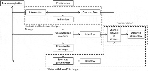
A prerequisite for streamflow naturalization is to identify the nature of human impacts and quantify them to determine which influences should be considered in the naturalization process. (modified after Botai et al. Citation2015) summarizes how human activities potentially affect the different components of the hydrological cycle. The main anthropogenic influences are land-cover and land-use change, streamflow regulation infrastructure, and withdrawals and discharges associated with different water uses (we did not consider here the impacts of human activities on climate, which ultimately impact water resources). Most of these influences potentially impact several components of the water cycle and so directly or indirectly affect the observed streamflow. We detail their main impacts in the following paragraphs. Some of these impacts may be interlinked or show counterbalancing effects. For example, in-basin water abstraction and release may balance out to some extent at the catchment scale, with limited net impact on mean flow at the yearly scale. However, they may more deeply modify catchment dynamics at the seasonal or event scale (high or low flows). Other activities will always strongly impact catchment water yields and hydrological dynamics, e.g. inter-basin water transfers.
Figure 1. Schematic representation of the impacts of human activities and the water cycle components they may directly impact (derived from Botai et al. Citation2015)
2.2 Dams and their associated storage
Among the 62 studies we reviewed that apply naturalization methods, 47 consider the impact of dams and artificial reservoirs. The hydrological modifications caused by dams have two origins (McCully Citation2001): the impacts due to the management of the dam (alternating operations of water storage and release) and the impacts stemming from the ponding effect of the reservoir. The presence of the stagnant water body created by the dam modifies several components of the local hydrological cycle, including evaporation and infiltration, and local precipitation for large dams (Degu and Hossain Citation2012, Haberlie et al. Citation2016). It may also strongly modify water quality (Winton et al. Citation2019). A permanent rise in the water table downstream can be caused by infiltration from the reservoir. The dam operations, consisting of periods of storage and release, regulate water flows in a way generally opposite to natural processes (typically flood alleviation or low-flow augmentation). They also result in various states of the lake behind the dam: for flood protection the reservoir should be as empty as possible, and for potable water supply the reservoir should be as full as possible (Margat and Andréassian Citation2008). From a temporal point of view, dams – especially hydro-power dams – can cause changes in flow seasonality and temporary fluctuations. The management of hydro-power reservoirs will depend on the profitability of electricity generation; for agriculture purposes, it will depend on crop needs. Since each dam has specific management rules, the impacts of the dams and their amplitudes are each time specific. Note that the cumulated effect of dams over a catchment may also be considered. This is often the case when there are many small farm dams spread over a catchment. In that situation, it is often much more difficult to access data for each dam, and a meta-analysis over all dams may be preferred (Hughes and Mantel Citation2010, Fowler et al. Citation2015, Dong et al. Citation2019).
2.3 Water withdrawal
Water withdrawals refer to the amount of freshwater that is artificially extracted from groundwater or surface water resources. The consumptive use of water corresponds to “the part of water withdrawn that is evaporated, transpired, incorporated into products or crops, consumed by humans or livestock, or otherwise not available for immediate use” (USGS and National Water-Use Science Project Citation2019). In our case, water returned to a different catchment than the point of withdrawal (inter-basin transfer) is considered a consumptive use. Therefore the quantity of water withdrawn from a river cannot be considered a good indicator of the actual quantitative impact of withdrawals, and the consumed water quantity should be used instead. According to a report of the World Water Development Program (WWAP Citation2009), agriculture is the largest consumer of water, with 90% consumption for drip irrigation and 50–60% for surface irrigation. The energy sector has the smallest consumption ratio, on the order of 1–2%. Domestic uses consume between 10 and 20% of the water withdrawn, and industry between 5 and 10%. These figures, however, remain overall estimates with large variability among regions. Water withdrawal can have a temporal impact because of the time lag between the time the water is withdrawn and the moment when the amount of water not consumed returns to the system (Kendy and Bredehoeft Citation2006).
Two sources of water are distinguished: water withdrawn from the groundwater and water abstracted from the surface. Surface water withdrawals have a direct and rapid impact on streamflow. Groundwater withdrawals have an indirect or delayed impact on river flows. Exchanges between surface water and groundwater can occur in both directions: a water table lower than the free surface of the river leads to a recharge of the aquifer by the river; the situation is reversed if the groundwater level is higher. Disturbance of the river–groundwater table balance can lead to a drop in the water table and/or an increase in the recharge rate, and so indirectly influences streamflow (Theis Citation1941). With only four articles considering groundwater abstraction, information on this type of withdrawals remains limited in our article database, but it is more widespread in operational studies to quantify the available water.
2.4 Water release
Water releases refer to the amount of water that is artificially brought to rivers. Two cases of water release can be distinguished: water releases originating from a withdrawal on the basin and the releases from an inter-basin water transfer. Inter-basin water transfer corresponds to the artificial withdrawal of water by ditch, canal or pipeline from its source in one basin for use in another (Slabbert Citation2007). The streamflow of the receiving basin can consequently be artificially increased. It can also impact the seasonality of river flows. For example, in several rivers in South Africa, inter-basin transfers aim to counter temporal variability and reduce the economic impact of a localized drought (Blanchon Citation2005). In the case of a release following a withdrawal within the catchment, one part of the water withdrawn having been consumed, the release has a reduced impact on the water resource quantity but an impact on the temporality of observed streamflow. In cases where the release location differs from the withdrawal location, release can impact the spatial distribution of water resources.
2.5 Land-use and land-cover change
Human activities can lead to a change in land use and land cover through urbanization, agricultural development, afforestation and deforestation. In the article database, human influences related to land use are taken into account in the naturalization process in only 11 studies, although they are the most pervasive anthropogenic impact (Pagano and Sorooshian Citation2005). Changes in land use and land cover have an indirect impact on flow. In modifying the quantity of energy absorbed by the surface, the evaporation rate is impacted and the precipitation rate can also be modified in changing the temperature gradient (Giambelluca Citation2005). Groundwater recharge and overland flow are also impacted. Moreover, numerous studies on land-use and land-cover change and its impact on the hydrological cycle have been carried out in relatively small paired catchments (Stednick Citation1996), with results that are difficult to generalize to a larger scale (Siriwardena et al. Citation2006, Zhang et al. Citation2018). The particularity of land-use change is that modification of the evapotranspiration–runoff relation at the local scale can impact the regional water balance because of changes in atmospheric circulation (Gash and Nobre Citation1997, Chase et al. Citation2000, Bosmans et al. Citation2017).
2.6 Combination of human impacts
In practice, observed flow at gauging stations is potentially influenced by several existing human activities in the basin: industries, energy production at the hydroelectric dam, agriculture, recreational activities (e.g. ski resorts, navigation for pleasure boating) and cities (see ).
Figure 2. A catchment impacted by human activities: gauging stations A1 and B1 are uninfluenced; gauging stations A2, B2 and C are candidates for naturalization procedures (Source: Institut national de recherche pour l’agriculture, l’alimentation et l'environnement (INRAE))
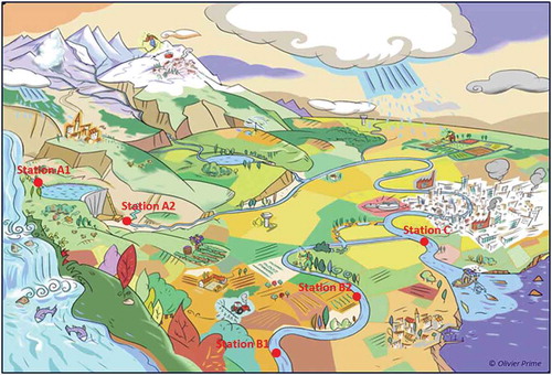
Flow regulation and direct withdrawal and discharge in rivers lead to a sudden change (typically on a daily basis) in river streamflow, whereas the impacts on the other components of the hydrological cycle can take longer to impact the observed streamflow. The time delay of the impact on the observed flow is also conditioned by the distance between the source of the influence and the gauging station, and by the water pathways. For example, in , stations A2 and C are both influenced by the dam’s management. Station A2, directly downstream of the dam, is impacted sooner than station C due to shorter propagation time.
The importance of the influenced signal contained in the observed streamflow can be conditioned by several factors. Distance plays a role because the intermediate hydrological processes can mitigate the importance of the impact (Mwedzi et al. Citation2016). Thus, the influence of the dam at station C is much less than at station A2, because dam releases will represent a smaller proportion of the total streamflow at station C than at station A2, due to inflows by the intermediary basin. In the case of basins with multiple influences, there can be compensations for some impacts: dam releases can be planned for agricultural withdrawals downstream, and therefore their impact may not be visible at the catchment outlet; the reservoir can increase groundwater recharge and thus compensate for the effects of underground withdrawals in summer (Constantz and Essaid Citation2007).
The impact of human activities on flow therefore depends on several factors specific to each basin (type of influence and location, basin characteristics). The following sections present whether and how impacts are taken into account in the naturalization process.
3 Defining the natural state of the flow regime
In naturalization studies, the purpose is to produce a reference flow regime for influenced rivers. First, the question of what the natural regime of a river corresponds to is addressed, followed by the use and identification of the reference period in particular studies.
3.1 Naturalization terminology
Examples of scientific definitions of “natural streamflow” or “natural regime” are provided in . For definitions (D1) and (D3), it is possible to have a natural streamflow despite the presence of anthropogenic factors as long as this does not significantly impact streamflow. Moreover, (D1) and (D2) include the notion of runoff, which can be modified by land-use change, without specifying whether it is from a natural or anthropogenic source. Only (D3), which remains quite comprehensive by referring to “human activity,” could take into account this notion of land-use and land-cover change by human intervention. The first three definitions refer to climate as a variable of the natural regime even though climate change is linked to greenhouse gases emitted by humans. Although (D2) does not refer to the catchment in its natural state, it refers to the drainage network, and thus the aspect of the natural geomorphology of the river. (D4) remains quite general by referring to natural conditions without explaining what they are.
Table 1. Definitions of “natural streamflow” and “natural regime” found in the literature
Although there is no common definition of natural streamflow, we summarize the previous definitions as follows: naturalized streamflow refers to an estimation of the natural flow under specified conditions of river basin development that include either no human impact or some defined low level of development (Wurbs Citation2006).
In the literature, it appears that the streamflow obtained under naturalization is not systematically called “naturalized streamflow” and may be designated by other words which are not necessarily synonymous. We present the terms by which some authors refer to naturalized flows and discuss the nuances in the definition of naturalized flow that these terms imply. First, there are terms referring to the influenced state of the basin, such as “regulated” or “influenced” streamflow. Following existing definitions of regulated flow (Bureau of Meteorology Citation2012, Environmental Protection Agency Citation2015, WaterNSW Citation2015, AFB, & Ministère chargé de l’environnement Citation2016a), an unregulated streamflow corresponds to a natural flow not impacted by artificial flow-regulation structures. The influences of land-use changes are therefore not included.
The terms “uninfluenced” and “unimpaired” flow refer to the flow of an undisturbed stream caused by human interventions and whose flows retain their general characteristics (AFB, & Ministère chargé de l’environnement Citation2016b). The uninfluenced flow thus takes into account a wider field of influence such as the change of land use and land cover. Other terms refer to the natural state of the catchment such as “flow under natural conditions” and “natural flow.” The “simulated natural streamflow” encountered in some studies refers to a naturalized streamflow obtained using a hydrological model. The terms “reconstructed or estimated natural/virgin streamflow” are synonymous with naturalized streamflow. Although all these terms refer to a naturalized flow, they may not reflect the same natural reference. So, to avoid confusion, the nuances between these terms must not be forgotten.
3.2 Determination of the basin’s baseline condition
As illustrated in , three periods can be distinguished in naturalization. The influenced period corresponds to the period when the observed flows are impacted by anthropogenic influences. Over this period, where no observation of the natural flow is available, one seeks to estimate natural streamflow using naturalization methods.
Figure 3. Diagram of the three periods distinguished in naturalization
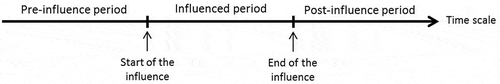
The pre-influence period serves as the basin’s baseline condition and is assumed to correspond to a past period when the observed flow is considered to have been free of the impact of the anthropogenic influences considered in the naturalization processes. Information from this pre-influence period is used by several naturalization methods. However, in many cases, the influence dates back before flow measurements were made, and there is therefore no information on natural flows.
The post-influence period corresponds to the period after the influences considered in the basin have ceased and it has returned to a natural state – which may be different from the state before the influence. This period is also relevant to serve as a natural reference period, if the system has had enough time to return to uninfluenced conditions. Obviously, the post-influence period does not exist in catchments under active anthropogenic activities. Studies exploiting the post-influence period mainly focus on sediment dynamics and fauna and flora species after a dam removal (Hart et al. Citation2002, Kibler et al. Citation2011, Magirl et al. Citation2014). Therefore, post-influence periods will not be discussed in this paper; however, some comments about the pre-influence period are somewhat transposable to post-influence.
The use of data from the pre-influence and post-influence periods to estimate the natural regime over a later influenced period raises a question about the reversibility of the system: if all activities stopped, would the river be able to return to the natural state that it would have reached if it had never been influenced (Cooper Citation2004)? In some cases, the influence of humans is so old that it has shaped the characteristics of the basin and represents the new natural condition. For example, in southern France, the system Neste was created in the 19th century for irrigation purposes. This network of canals strongly impacted the land use of a large number of small catchments, with conditions now that are very different from those that went before (Villocel Citation2002, Tardieu Citation2008). Still in France, many wetlands were dried out for sanitary or agricultural objectives, such as the Marais Poitevin since the beginning of the 18th century, and it would be difficult to return to the pristine condition (Godet and Thomas Citation2013).
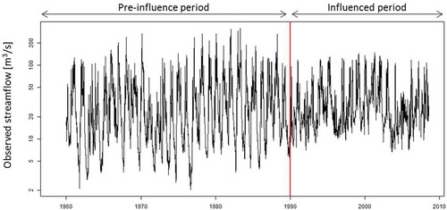
Theoretically, the separation of the pre-influence and influenced periods should match the start of the influence on the basin. In practice, in the case of dam commissioning, as illustrated for the Aube Dam (), the change in the observed flow time series is abrupt and so the separation is easily identifiable. In other cases, such as withdrawals or small farm dams, which may gradually appear in the basin and evolve over time, or in the case of gradual land-use and land-cover change, the date of implementation of all the influences is rarely accessible and there is generally no abrupt change in the observed flow time series, which complicates dating the separate intervals.
Figure 4. Hydrograph at logarithmic scale of the daily observed streamflow of the Aube River at Arcis-sur-Aube (France, 3560 km2). The red line corresponds to the upstream dam’s commissioning in 1990
In naturalization studies, change-point detection tests (Hubert et al. Citation1989, Andréassian et al. Citation2003) are mainly used to distinguish the pre-influence and influenced periods (Wang et al. Citation2009, Citation2013, Jiang et al. Citation2011, Bao et al. Citation2012, Zhan et al. Citation2013, Guo et al. Citation2014, Hu et al. Citation2015, Gu et al. Citation2017). The identified break point most often corresponds to a statistically significant change in the observed flow time series, but this break can have an anthropogenic origin (dam, urbanization, etc.), may be natural (natural change in the morphology of the river) or may stem from climatic variability or a data problem (change in data measurement devices, etc.). With this method, it is important to underline that anthropogenic disturbances can still exist during the period defined as pre-influence (Jiang et al. Citation2011) and that these influences can therefore impact the naturalized flows obtained.
4 Methods to naturalize streamflow
4.1 Overview on naturalization methods
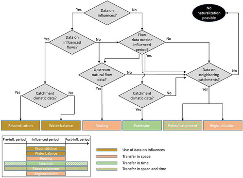
We have identified six main naturalization methods in the literature: (1) reconstitution, (2) water balance, (3) routing, (4) extension, (5) paired catchment and (6) regionalization (or neighbourhood). These methods differ mainly according to the input data and the underlying models used.
The reconstitution, extension and neighbourhood methods are based on a hydrological model simulating a naturalized streamflow with an estimated set of parameters reflecting the natural hydrological conditions. In reconstitution, lacking past observations, information on the observed influenced streamflow and the anthropogenic influences are exploited to indirectly estimate the set of parameters representing natural hydrological conditions. In the extension method, past observations of natural flows on the target catchment are used to estimate the set of parameters reflecting the natural hydrological conditions. In the neighbourhood method, existing observations of neighbouring basins are exploited to estimate the set of parameters. Although these methods use a hydrological model, they rely on different assumptions and data to obtain the model parameter set.
provides a decision tree for the use of the various methods. The starting key question is generally the availability of input data on influences, followed by the availability of data from the pre- or post-influenced period, or of regional data. The use of these different data raises hypotheses for the application of the methods. shows which methods can be applied based on the available data. If all the data are available, all the methods can be applied. If no data are available, one may come to the conclusion that no flow naturalization is possible (black ellipse on the graph). In that case, one may appeal to hydrological models implemented at the global scale, which do not require local or regional data. However, the reliability of these models at the local scale remains limited (Beck et al., Citation2017). That is why this option will not be further discussed in this review.
Figure 5. Diagram of the choice of naturalization according to the available data
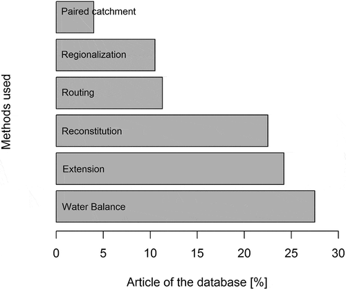
In the following sections, an explanation of the main hypotheses raised by the naturalization methods is provided in order to identify their application conditions. shows which methods are used in our article database.
Figure 6. Naturalization methods applied in the studies reviewed
4.2 Methods using data on influences
4.2.1 Water balance
The water balance method consists in decomposing flow into a natural part and an influenced part at the scale of the influenced system (typically an artificial reservoir), by removing the volume variation in the river induced by the source of influence, ∆V, during the time interval ∆t, from the influenced observed flow, Qobserved, to obtain the naturalized flow, Qnaturalized (EquationEquation 1(1)
(1) ). The system studied can be a river reach where there is a water withdrawal or release, or a reach downstream of an influence. By convention, in the case of a water discharge, ∆V will be negative. In the case of a water withdrawal, ∆V will be positive. This method is generally applied at a gauging station located downstream of the influences in the river, although in principle it is also applicable to a fictitious point where flow data obtained through regionalization methods are available. Hydraulic propagation between the influence and the station can have an impact on the computation of the naturalized streamflow. The ∆V computed at a moment t will not have an immediate impact on the observed streamflow at the downstream station, but will have an impact at the time t + ∆p, where ∆p corresponds to the propagation time. If the propagation time is much lower than the study time step, then the propagation effect can be ignored. Otherwise, it is advisable to use a propagation model. The choice of time step will define the hydrological processes to be taken into account and their influences to be considered.
The water balance method is the most widely used in the studies. lists the studies using this method. It appears that this method, mainly constrained by the availability of data, is mostly applied at a daily time step over periods ranging from a few months to several decades. However, if the method is applied over a long period of time, there may be disparities in the quality of the naturalized flows obtained over the entire period. This may be due to the evolution of the quality of the measured flows (Littlewood and Marsh Citation1996). In the studies taking into account the influence of dams, it appears that, for the most part, only the impact of dam regulation operations is taken into account (Assani et al. Citation1999, Peters and Prowse Citation2001, Naik and Jay Citation2005, Page et al. Citation2005, Kim and Wurbs Citation2011, Yuan et al. Citation2017). Some studies also take into account evaporation from the reservoirs (Fantin-Cruz et al. Citation2015, Tongal et al. Citation2017) and precipitation falling on the reservoirs (Gu et al. Citation2017), but no studies seem to take into account the underground exchanges induced by the reservoir. For studies taking into account withdrawals, it appears that it is the volume of water consumed that is taken into account in naturalization and not the volume of water withdrawn (Wallace and Pavvloski Citation1988, Littlewood and Marsh Citation1996, Wurbs Citation2006, Davtalab et al. Citation2017).
Table 2. Synthesis of studies applying water balance methods
4.2.2 Reconstitution method
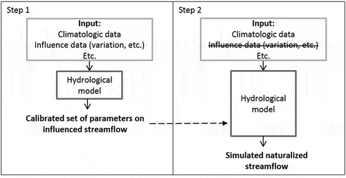
The reconstitution method is based on the exploitation of the influenced observed streamflow and the information available on influences during the influenced period and on the use of hydrological models taking anthropogenic influences explicitly into account. As illustrated in , the reconstitution method consists first in calibrating the hydrological model on the influenced observed streamflow, taking into account the anthropogenic influences. Then the set of parameters obtained is used to simulate a naturalized streamflow without taking into account the anthropogenic influences. In cases where the signal of influence in the observed flow is predominant over the natural signal, it is important to ensure that the calibrated parameter set is able to reflect the natural catchment behaviour. Step 1 is common to all studies applying the reconstitution method, with more or less complex calibration methods depending on the model used and the influence considered. There are some variants of step 2, for the estimation of the naturalized streamflow. One variant corresponds to the case where the model output considered is the time series of the influences. The second step then corresponds to the application of the water balance method where the volume variation of the influences is added to the observed streamflow (Maheshwari et al. Citation1995, Dunn and Ferrier Citation1999, Wurbs Citation2006). Another more hydraulics-oriented variant, relevant for the semi-distributed and distributed models with an in-stream flow routing, consists at step 2 of propagating the upstream natural streamflow if available (Kim et al. Citation2012). In the case of an impact of land-use and cover change, in the second step the parameter and input corresponding to influenced land use are changed to correspond to the pre-influenced state (Nobert and Jeremiah Citation2012, Shi et al. Citation2013, Zhang et al. Citation2016, Yin et al. Citation2017).
Figure 7. Illustration of the two application steps of the reconstitution method
Since studies are often not very explicit in terms of the model calibration with anthropogenic influences, it is difficult to clearly identify which studies apply reconstitution methods. presents a synthesis of the models used in studies applying the reconstitution method, the time step of the naturalized flow, the influence taken into account as input in the studies and the simulated flow. The impacts of dams and reservoirs are often the main issue in reconstitution studies. This can be explained by the fact that their management can be simulated. The second most studied influence is land-use and land-cover changes, which are taken into account by physically based hydrological models such as Soil and Water Assessment Tool (SWAT) (see ). The semi-distributed spatial resolution is adopted by most studies. In the case of large catchments, the influences can be localized in space and attenuation of the influences along the river are more accurately considered.
Table 3. Synthesis of studies applying reconstitution methods
4.2.3 Comparison
The reconstitution and water balance methods are based on the hypothesis that by knowing the impacts of the various influences on the observed flow, it is possible to have a naturalized flow free from these influences. As no study, to our knowledge, has made a comparison between the reconstitution method and the water balance method, it is not possible to know which one is the most suitable. However, here are a few elements that differentiate these methods and may guide their choice:
Data availability. The water balance method requires time series data on the entire period to naturalize. The advantage of the reconstitution method is that once the parameter set has been obtained, it is theoretically applicable to other periods.
Setting up the model. The water balance method seems to be easier to apply than the reconstitution method, which requires the implementation of a hydrological model on the basin. However, the use of a hydrological model can facilitate several steps such as estimating the volumes of influences that can be incorporated into the model or estimating travel time. It is difficult to say a priori which method will be easier to apply. This depends primarily on the catchment area and the influences considered.
4.3 Methods using observations from the pre-influence period
4.3.1 Extension method
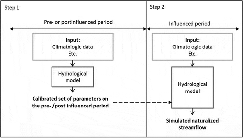
The extension method is based on the exploitation of observed data of the target catchment from the pre-influence period and on the use of a hydrological model able to simulate the natural streamflow of the target catchment. The required data for the pre-influence period are, at minimum, the natural observed streamflow and the input data required by the model. On the influenced period, the input data required to use the model are necessary. The extension method consists in calibrating the hydrological model on the natural observed streamflow of the pre-influence period and then in using the set of parameters obtained on the influenced period to simulate a naturalized streamflow () Note that the same methodology can be applied if data are available on the post-influence period instead of pre-influence period.
Figure 8. Illustration of the two application steps of the extension method
presents an overview of the studies applying the extension method and the hydrological models used. The common point of the models is their ability to simulate a natural flow. The models used in these studies show differences in terms of the type and level of complexity. Some studies used empirical models which establish a purely mathematical relationship between natural flow and weather variables over the pre-influence period. Wen (Citation2009) established a multi-regression model with the precipitation and the maximum temperature data at the monthly time step; Jiang et al. (Citation2011) built a multi-regression model with the precipitation and the potential evapotranspiration; Ahn and Merwade (Citation2014) also take into account the drainage area. Other studies applied more complex models, such as conceptual hydrological models (Wang et al. Citation2013, Zhan et al. Citation2013, Guo et al. Citation2014; Chang et al. Citation2015b), or physical models (Ma et al. Citation2010, Wang et al. Citation2010, Jiang et al. Citation2011, Bao et al. Citation2012, Chang et al. Citation2015b). Jiang et al. (Citation2011) and Chang et al. (Citation2015b), who used models of different types, showed that the results obtained with the two model types are comparable.
Table 4. Synthesis of studies applying extension methods
4.3.2 Paired catchment method
This method is explained here but also partly belongs to the family of methods exploiting regional information (see ). This method is based on the implementation of a statistical flow-rate relationship between the target station to naturalize and natural donor stations over the pre-influence period. The natural donor catchment is generally a catchment that is spatially close to (but not nested in) the target catchment, of similar size. There is no hydrological model involved in this method. This approach is not limited to cases of experimental basins to evaluate land-use and land-cover changes (Brown et al. Citation2005). To naturalize the flows of La Grande Rivière in Canada, Hernández-Henríquez et al. (Citation2010) established a flow-rate relation over the pre-influence period by applying a variant of the Hirsh MOVE I method (Hirsch Citation1982). On the Lena River in the Arctic, influenced by a reservoir dam, Ye et al. (Citation2003) established a regression on the pre-influence period between a station downstream of the dam and five natural upstream uninfluenced stations. Smakhtin (Citation1999) proposed the same principle for catchments in South Africa. In China, Huo et al. (Citation2008) established flow-rate relationships, including climatic variables (precipitation and temperature), between the uninfluenced upstream and downstream stations. The relation proposed by Huo et al. (Citation2008) differs from the conventional paired-basin methods (Andréassian et al. Citation2012) because they also use climatic information. Other variants exploiting the paired-catchment relationship can be applied without parameter calibration. The drainage area ratio method (Hirsch Citation1979) and different variants, requiring only access to the catchment’s area value, are applied in many naturalization studies (Wurbs Citation2006, Kim Citation2015, Rahman and Bowling Citation2018). In any case, these approaches make the strong assumption that the departure of observed influenced flows from the relationship with paired catchment flow would be due to the influence only, which may not be always the case.
4.3.3 Comparison
Extension and paired catchment methods are based on the hypothesis that relations established over the pre-influence period are stationary and remain valid over the influenced period. For the extension method, running a hydrological model under climatic conditions that are different for the calibration period can generate uncertainties (Coron et al. Citation2012). The source of these uncertainties can be partly explained by the fact that, in the models, several physical parameters (soil, vegetation, etc.) are related to climatic conditions. The calibration of the model creates an interaction between the parameters and the climatic characteristics of the calibration period. The robustness of the model is usually tested on the pre-influence period by calibrating the model on a sub-period and validating it on another one (Wang et al. Citation2010, Citation2013, Jiang et al. Citation2011, Bao et al. Citation2012, Guo et al. Citation2014). For the paired catchment method, the limitation is the climatic gradient between the basins, which could lead to the two basins evolving differently. In the pre-influenced period, similar climatic conditions, landforms, soils, vegetation and hydrological processes between the basins can reduce the uncertainties associated with the natural evolution state of the target catchment (Hernández-Henríquez et al. Citation2010).
These two methods can be distinguished by their level of complexity. The extension method requires a rainfall–runoff model and meteorological data as input, whereas the paired-basins method is simpler because it consists in establishing a relationship between two neighbouring catchments and only requires streamflow measurements. Despite these differences in complexity, Andréassian et al. (Citation2012) showed that the paired-basin methods can give better performance than the use of a rainfall–runoff model when the density of gauging stations is quite high.
4.4 Methods using regional information
4.4.1 Routing modelling
Routing models can propagate the observed streamflow from upstream to downstream. In the case where the upstream recorded streamflow is uninfluenced, it can be propagated by a hydraulic model (or other simpler propagation or statistical methods) to obtain a naturalized downstream streamflow.
presents studies applying routing modelling methods to naturalize. The influences taken into account in these studies directly affect flows due to infrastructures built in the river. In these studies, the hydraulic models used assume that the river bed topography would still be the same without the dams or levees. The implementation of routing modelling methods is often time consuming and requires many data to calibrate the hydraulic model (Shiklomanov and Lammers Citation2009). This is especially the case when important transmission losses occur and must be accounted for (Pacheco-Guerrero et al. Citation2017, Hughes Citation2019). When the upstream flows are influenced, the flow can be naturalized and then propagated using a hydraulic model (Peters and Prowse Citation2001). Another variant consists in using a hydraulic model that explicitly takes into account the different structures (dam, weir, levee, etc.) that may alter streamflow. The model is first calibrated on the flow conditions of the influenced period. Then, to obtain a naturalized flow, the various obstacles are removed from the propagation model (Ahn et al. Citation2006, Peters et al. Citation2006; Wyrick et al. Citation2009). Wu et al. (Citation2015) assume that the hydraulic propagation has no impact and sum the natural upstream flows to naturalize.
Table 5. Synthesis of models used in studies applying routing modelling methods
4.4.2 Regionalization
Regionalization methods exploit the similarity between catchments to estimate streamflow. Although mainly used for ungauged or poorly gauged basins, their application in naturalization studies is an interesting option, for several reasons. First, the water balance and reconstitution methods require good knowledge and access to the data used to characterize the influences, whereas regionalization methods are usable on a basin with limited data (Ye et al. Citation2003, Hernández-Henríquez et al. Citation2010). Secondly, the principle of the extension methods is based on the temporal transposability of streamflow. Regionalization methods can be viewed as a variant based on spatial transposability.
4.4.2.1 Regionalization of the hydrological regimes and flow duration curves
In cases where only the flow characteristics of the natural basin’s behaviour are investigated and complete time series are not sought, the regionalization of a hydrological regime can be used. For example, in Switzerland, the natural monthly regimes of Alpine basins have been classified into six groups according to the average altitude of the catchments and the proportion of their glacier-covered area. Therefore, due to the physical characteristics of the influenced catchments and an estimate of the average annual flow, Weingartner and Aschwanden (Citation1994) estimated their natural monthly regime, with an uncertainty ranging from 10 to 20%. In Spanish basins, Fernández et al. (Citation2012) estimated the naturalized monthly flow with a hydrological model at the influenced stations. Then, to estimate the naturalized regime at a daily time step, they calculated daily distribution coefficients on neighbouring natural stations. These distribution coefficients were then applied to the naturalized monthly flows that had a naturalized daily regime. Here, since the focus is on methods for obtaining naturalized flow time series, the methods of this subsection will not be further discussed. However, they remain operationally used in many countries, in cases where only synthetic streamflow descriptors are needed.
4.4.2.2 Neighbourhood method
The neighbourhood method consists in estimating the hydrological model parameters on natural neighbouring basins. The selection criteria for natural neighbouring basins are related to geographical distance or the physical characteristics of the basins (Hrachowitz et al. Citation2013). This method is not currently used on gauged stations in naturalization studies. However, like the extension and reconstitution methods, it uses a hydrological model with an alternative approach to estimate the model parameter. It may be of particular interest when there are no existing natural flow data on the pre-influence period nor on the influences themselves during the influenced period.
4.4.3 Comparison
In this family, the routing method seems to be, a priori, the method giving the best estimate of natural flow since it directly exploits measurements of natural flows upstream of the basins. However, in the case where the intermediate basin has a significant influence on the flow, it may be necessary to also use a hydrological model to simulate the contribution of the intermediate flow (Wyrick et al. Citation2009). It is also a complex method to use in the case of large transmission losses between the upstream and downstream station (e.g. in arid regions) (Schreiner‐McGraw and Vivoni Citation2018). The paired catchment method can also be applied in cases where upstream uninfluenced flow measurements are available. What differentiates it from the routing method is that it is based on a flow rate relationship that can indirectly take into account the inflows from the intermediate basin. Like the paired catchment method, the neighbourhood method also exploits information from basins with a natural regime. The significant difference between these two methods is that neighbourhood is primarily aimed at transferring parameter sets from a natural catchment to the influenced catchment. The assumptions involved in these methods, and their strengths and weaknesses, have been the topic of several studies within the framework of the IAHS decade on Prediction in Ungauged Basins (Sivapalan et al. Citation2003, Hrachowitz et al. Citation2013).
5 Discussion
5.1 Defining naturalized streamflow
When discussing the definition of a natural regime, we showed that there is no consensus on what “naturalized flow” and the “natural state” of a basin should refer to, exactly. This impacts the choice of the reference period in the various studies. In practice, the definition of naturalized streamflow should be a compromise among the following:
Our knowledge of the interactions between human activities and the water cycle and the limit of the definition to be adopted. Since the water cycle is linked to several other environmental cycles (energy, chemistry, sedimentation, etc.), this raises the question of the natural state of these other environmental cycles and their interactions with the water cycle. Typically, the issue of defining a natural reference in the climate or ecological domains has been discussed and results from a compromise among knowledge, data availability and objectives in the use of the reference (Brázdil et al. Citation2005, Roubicek Citation2010, Davis Citation2015, Gatti et al. Citation2015).
A definition not too restrictive to be applicable to a large number of case studies. Ideally, the reference conditions should correspond to minimally disturbed conditions (Stoddard et al. Citation2006), i.e. conditions where there is no significant anthropogenic disturbance. In practice this would be very constraining because it is difficult nowadays to access data from basins that are not disturbed by human activities. In Europe, there are no data on the natural state of a catchment because the continent has long been densely populated, and the landscapes and land uses have been modified by human presence (Stahl et al. Citation2010). Moreover, in some studies, only the naturalization of major influences is desired. In some cases, the naturalized flow can be obtained by removing a single influence to quantify the role of the influence in the observed flow.
The summary of previous definitions that we gave in section 3.1 may meet this compromise. This is actually a key issue when establishing hydrometric reference networks. Since they should be representative of natural flow conditions, the question of the criteria to be met in order to consider the corresponding catchments as natural references is raised (Whitfield et al. Citation2012). It appears that the definition of conditions varies among national networks. In Canada, where there are many catchments in pristine conditions, criteria are more rigorous, whereas the impact of influences on natural flow regimes is visible across many rivers of the UK, for instance.
The current perspective would be to define the naturalized flow as corresponding to a more or less natural state of the basin and to express which influences and associated impacts are considered in each study. Another perspective is to use a more comprehensive approach, consistent with the definition of naturalized flow chosen, to identify the pre-influence period. In the reviewed studies applying naturalization methods, the methods to identify the reference period are currently limited to change-point detection tests, which raise several issues concerning the origin of the change point. It would also be interesting to have methods to detect a certain level of influence on the basin.
Although defining terms appears essential to understand and compare studies, the definition process can lead to a reflection on the role of the influences in the methods and the hypotheses raised. For example, in the case of the extension method, setting it at a pre-influence period may imply accounting for change in land use to obtain the naturalized flow.
5.2 Choice of naturalization methods
By comparing the characteristics of the studies with the choice of the naturalization methods applied, it appears that the same methods are applied on basins with different areas, from the basin scale (100–10 000 km2) to the regional scale (100 000–1 000 000 km2), and with different influences. Methodological aspects of the studies such as the time step and the length of the available time series to naturalize do not seem to play a major role in the choice. This raises the question of the criteria that can motivate authors to choose one method over another.
5.2.1 Data availability
From a practical point of view, data availability is the first selection criterion (), which is also reflected in the decision tree illustrated in . Thus, the water balance and reconstitution methods use data on influences. The paired catchment and neighbourhood methods need data on non-influenced catchments. The routing modelling method requires a natural upstream flow to propagate it downstream. The extension and paired catchment methods need data on the past observed natural streamflow. It is clear that several of these methods are relatively similar and that they differ only in the tools used. In this section, we will discuss the aspects that can influence the choice of the applied methods.
Table 6. Synthesis of input data and tools used by each of the naturalization methods
5.2.2 Distance between the source of influence and the gauging station
Distance is taken into account by the water balance and the routing modelling methods with the propagation time, and by the reconstitution methods, which take it into account according to the structure of the model used and the parameters. For the transfer modelling family methods, in cases where intermediate hydrological phenomena such as runoff or river–groundwater exchange have a potential impact on the routed flow, a hydrological model should be used to simulate them.
5.2.3 Type of influences
In the transfer modelling family, routing modelling methods are used only to take into account influences that directly impact the flow, as is the case for dams and withdrawals. For the water balance method, all the influences and their associated impact on the hydrological cycle could theoretically be taken into account via the ∆V. In practice, indirect impacts on river streamflow are easier to take into account with a method from the hydrological model family.
In the hydrological method family, theoretically the entire impact on the hydrological cycle could be considered. In practice, the types of influences present in the basin seem to impact the choice of methods. In studies that take into account land-use and land-cover changes in their naturalization process, only extension and reconstitution methods are used. The extension method is calibrated on the basin conditions before the evolution of the cover. The reconstitution method makes it possible to take the land cover directly into account during the calibration and then to modify it. As land-use changes indirectly modify the flow, it is easier to take these interactions into account with a hydrological model. For the regionalization methods, this would require a neighbouring basin with a land cover similar to the influenced basin in its natural state. These methods could be applied on small experimental paired catchments (Brown et al. Citation2005) but do not seem to be applicable to large catchments.
Regionalization methods are applied on catchments which are strongly influenced by dams and other influences. This can be explained by the fact that it is now difficult to access databases with completely uninfluenced catchments. Weingartner and Aschwanden (Citation1994) explain that regionalization methods are easier to apply in cases where the hydrological conditions encountered are very complex, as in multi-influenced basins. The complexity of the influences and their impact on the catchment could be a limit of the reconstitution method. For example, in cases where irrigation return flow is taken into account, the difficulty in quantifying it (Dewandel et al. Citation2008) may lead to eliminating the reconstitution method as a choice.
5.3 Operational implementation of naturalization methods: a case study on the Rhône basin (France)
From theory to practice, it is always useful to see the way practitioners implement methods proposed in the scientific literature. We describe a case study from France. In France, one of the objectives of the Law on Water and Aquatic Environments (LEMA in French) of 30 December 2006 is to restore the balance between water supply and demand. Consequently, studies of “withdrawable” water volumes (i.e. water available for withdraw/human-use) were carried out at the catchment scale to determine the quantitative state of water resources and then to propose a preservation strategy for the existing balance or to reduce the deficit. These studies comprise several phases, including an important phase on the identification and quantification of anthropogenic influences and a phase on the estimation of the water resource using naturalization methods. The reports produced at the end of these studies are a useful source of information on the application of naturalization methods in operational contexts. Because low-flow periods are of particular concern, naturalized flows are preferentially obtained at a daily scale to calculate drought indicators.
Among the many reports available, we selected those covering over 20 basins in the Rhône-Mediterranean Water Agency district (Appendix ). These reports were generally produced by consulting firms and were chosen here to produce the widest possible panorama (Appendix ). Naturalization methods were applied on sub-basins from a few dozen to several hundreds of square kilometres. Note that a study at the scale of whole Rhône basin (BRL Ingénierie, Citation2014) produced monthly naturalized flows on a set of 17 sub-basins using mainly water balance approaches (and in a few cases hydrological modelling to extend time series).
With regard to the choice of methods, the most widely used methods are the water balance and the reconstitution methods. The choice of the methods is not clearly justified but can be explained by several factors. First, all influences in the basin are taken into account. This excludes the extension method where it is almost impossible to have a period when there is no withdrawal, and the regionalization method where it is also complicated to have neighbouring basins with no withdrawals. However, a variant of the neighbourhood method used in an operational context consists in calibrating the hydrological model on the naturalized flow of the upstream influenced sub-basins, and then to use the set of parameters obtained on the influenced downstream basin (CEREG Ingénierie Citation2011). Moreover, in these studies considerable preliminary work is undertaken to identify and quantify the anthropogenic influences present in the basins. This facilitates the application of the water balance and reconstitution methods.
The synthesis of these reports also highlights the implementation of hybrid naturalization methods to address data gaps. Given that hydrological indicators are calculated on the naturalized flow series, the times series must be long enough. These hybrid versions are presented as a solution in cases where the observational data on influence and streamflow are too short. One version is to first naturalize the streamflow with the water balance method and then to apply the extension method in calibrating the hydrological model on these naturalized flows. Inversely, the influenced flow time series can be extended with a hydrological model and then be naturalized with the water balance method. It should be noted that each addition of steps in the naturalization process is a potential source of uncertainty.
In the terms of reference of these studies, the authors were asked to clarify the limits and uncertainties related to the naturalization process. The level of reflection is very heterogeneous depending on the studies. It appears that most of the authors were able to identify sources of uncertainty. The main sources of uncertainties cited were the streamflow data, the data on the influence and the climatic data used as model input and model calibration. No study clearly quantified the global uncertainty of the naturalized streamflow obtained. In the Les Gardons catchment, it was highlighted that a 7% error on the naturalized flow had an impact on the study conclusions.
5.4 Level of confidence associated with naturalized streamflow
The preceding section on the operational application of naturalization methods in France showed that there is a need to determine how to assign a level of confidence to naturalized flow. Because naturalized streamflow is used as a reference for many applications (as discussed in section 1.2), it is important to quantify the associated uncertainties in order to make robust decisions (Refsgaard et al. Citation2007). The error associated with naturalized flows is not directly quantifiable because there is no observation of natural flows over the influenced period. Estimation of the confidence in the methods can therefore only be done indirectly. Among the articles analysed, there does not currently seem to be a methodology to evaluate the naturalization process. In this part, we discuss how to indirectly estimate the confidence in results.
5.4.1 Uncertainties in data
To estimate which method is the most appropriate, a first reflection can be carried out on the quality of the input data (McMillan et al. Citation2012). As discussed in section 5.2, naturalization methods use different input data which can generate different levels of uncertainty. The main categories of input data are:
Streamflow time series. We distinguish the streamflow time series corresponding to an observed natural flow and the time series corresponding to an influenced observed flow. The main uncertainties come from the measurement system in place, the operational conditions and the post-processing step to estimate the flow (e.g. the stage–discharge relationship). Usually, a post-processing step corrects the occasional errors. In the case of a direct impact, the influenced series can be distinguished from the natural series by the presence of sudden changes in the time series. This implies a more thorough post-treatment to distinguish changes due to measurement errors from those due to anthropogenic influences. Ideally, the measurement system should not change over time. Naik and Jay (Citation2005) pointed out that flow errors can be much more important at the beginning of the period of record. When choosing a method from the hydrological modelling family, questions should be raised about the confidence placed in the natural flow in the past and the observed flow in the present. When the observed data appear uncertain in both cases, it may be beneficial to use the neighbouring basin method.
Climatic time series. The main climatic variables used in the studies are precipitation and evapotranspiration. Precipitation estimation at the catchment scale is carried out using interpolation methods on local rainfall measurements. The measurement system put in place must therefore be adapted to the spatial and temporal variability of rainfall events in the basin (Lebecherel Citation2015). Since actual evapotranspiration is not measurable at the catchment scale, point evapotranspiration is used most of the time in the studies. However, this potential evapotranspiration corresponds to a model output (Oudin et al. Citation2005), and therefore includes uncertainties. Precipitation can also be estimated by radar data. In contrast to the rain gauge, it is an indirect measurement which is also uncertain.
Volume time series of human influences. Since the influence measurements are not always available, different techniques and assumptions are used to estimate influence time series. For example, in the naturalization studies examining agricultural withdrawals, the volume time series are estimated based on data reported by farmers (Irwin et al. Citation1975) or models based on cropping patterns, irrigation water needs and irrigation efficiency (Wallace and Pavvloski Citation1988, Davtalab et al. Citation2017). Uncertainties associated with these processes seem not to be quantified, but it can be assumed that these uncertainties could be greater than for the other input data. It is also difficult in naturalization studies to obtain sufficient data to characterize all the influences at play in the catchment. Often one has data on the major influences (typically dams, abstractions in rivers), but it is harder to quantify the impact of other influences on flows (land-use change, groundwater abstractions). This may leave a level of uncertainty in naturalized flow estimates that is difficult to remove.
A first perspective would be to assess the impact of the quality of these data on the naturalized flow obtained in a sensitivity study (Devak and Dhanya Citation2017). Model parameters are sensitive to the errors contained in input data. Several studies have already shown the sensitivity of the models to climate variables (Andréassian et al. Citation2004, Oudin et al. Citation2006). For example, Andréassian et al. (Citation2004) showed that having a better estimate of potential evapotranspiration does not give better results. In the case of withdrawable water volume studies in France, there are often strong uncertainties on the influence data, especially on irrigation data. It would therefore have been interesting to see the sensitivity of the calculated hydrological indicators to influence data.
5.4.2 Uncertainties in model structure
Model structures can be a source of uncertainties if they are not in line with reality (Pechlivanidis et al. Citation2011). The model is a simplification of reality and it may be that not all processes are represented. In the reconstitution method, where the model takes anthropogenic influences into account, it is important to ensure that the structure of the model is adapted to represent the potential impacts of the human activities on the different components of the hydrological cycle. The structure of the water balance method can be attractive because of its simplicity, but during low-flow periods, errors can lead to obtaining abnormally low or even negative flow rates (Littlewood and Marsh Citation1996, Agosta Citation2007). With the reconstitution method, the simulated streamflow can be extremely low, which raises questions about its interpretability, especially in intermittent rivers (De Girolamo et al. Citation2015).
5.4.3 Validation of the method’s hypothesis
Each naturalization method is based on different assumptions (see section 4). One key issue in all methods is the uncertainty linked to the transfer of information in space and time. This aspect is, however, not so easy to quantify in the case of naturalization since no natural flow observation is available on the influenced period, and standard split sample or proxy-basin approaches (Klemes Citation1986) cannot be directly applied.
To assess whether the method and tools used are appropriate and thus reinforce our confidence in the results, several methods applied in the literature can be used.
In the case of the hydrological modelling family, methods are based on the transferability of the parameter set. In fact, there is no single set of parameters that can perfectly reproduce the uninfluenced flow (Beven Citation2000). The problem in naturalization is to know which method makes it possible to transfer the parameter sets with the least possible uncertainty. With a temporal transposition, robustness can be assessed using the split-sample test (Klemes Citation1986, Coron et al. Citation2012). This method consists of evaluating the performance obtained over a subperiod different from the calibration period. In the case of a spatial-proximity-transposition, robustness can be assessed using the hydrometrical desert method (Lebecherel et al. Citation2016). For the reconstitution method, the uncertainty obtained at calibration on the simulated influenced streamflow can be transferred to the simulated naturalized streamflow.
6 Conclusion
Human activities can directly impact the observed flow or several components of the hydrological cycle. These human influences can have an impact at the catchment, regional or global level. Consequently, most of the observed flows are influenced. In order to have a reference on the natural regime of influenced rivers, an increasing number of studies apply different naturalization methods. However, no state of the art on the topic has yet been made. The inventory of the terms to designate a naturalized streamflow shows that there are several definitions, considering different human influences. We believe that it would currently be too restrictive to propose a single definition of the naturalized flow. We advise that studies propose a clear definition of the influences and impacts considered by the naturalization process.
The main naturalization methods were presented, as well as a classification into three families based on the information they used. Although data availability appears to be the main constraint in the choice of methods to be applied, other criteria play an important role. When intermediate phenomena such as runoff impact the water flow from upstream to downstream, a method from the hydrological modelling family will be more appropriate. The influences and their impacts considered in the naturalization process also lead to questioning the choice of methods and tools used.
The example of the application of operational methods shows that the most commonly applied methods for estimating water resources are the water balance and reconstitution methods. This choice is explained by the fact that the authors’ goal is to take into account all the influences of the basins and by the difficulty of having access at a completely natural reference over an earlier period or a neighbouring basin. The development of hybrid methods is a consequence of the difficulty of obtaining both an estimate of the natural flow without any influence and a sufficiently long series to calculate robust hydrological indicators.
In these studies of withdrawable water volumes, the uncertainties associated with the naturalization procedure were investigated. It appeared that the authors could identify most sources of uncertainty, but did not quantify the total uncertainty of the naturalized flow obtained. The difficulty in estimating the error associated with naturalized flows is that this can only be done indirectly because the naturalized flow is obtained over a period when there is no direct observation of the natural flow. A first option to estimate the confidence of the naturalized flows would be to assess their sensitivity to the input data, knowing that very often these inputs do not correspond to observations. A second option would be to indirectly assess the assumptions raised by the methods. Methodologies have been established in the literature to assess the ability of models to transfer a set of parameters spatially or temporally.
Acknowledgements
The authors thank the Office français de la biodiversité (OFB) for the financial support of the first author. The Land and Water team of CSIRO is thanked for supporting a research residency of the first author at Canberra, and The Bureau of Meteorology is acknowledged for making data available for this study. Rob Pipunic and Christopher Pickett-Heaps from the Bureau of Meteorology are thanked for their comments prior to submission. The authors also thank the two anonymous reviewers and the Associate Editor for their comments which helped improving the article.
Disclosure statement
No potential conflict of interest was reported by the authors.
References
- Acreman, M., et al. 2008. Developing environmental standards for abstractions from UK rivers to implement the EU Water Framework Directive/Développement de standards environnementaux sur les prélèvements d’eau en rivière au Royaume Uni pour la mise en œuvre de la directive cadre sur l’eau de l’Union Européenne. Hydrological Sciences Journal, 53 (6), 1105–1120. doi:10.1623/hysj.53.6.1105
- Acreman, M.C. and Dunbar, M.J., 2004. Defining environmental river flow requirements - a review. Hydrology and Earth System Sciences, 8 (5), 861–876. doi:10.5194/hess-8-861-2004
- AFB, & Ministère chargé de l’environnement, 2016a. Débit contrôlé - Glossaire sur l’eau [Site de Eaufrance]. Glossaire Sur l’eau. Available from: http://www.glossaire.eaufrance.fr/fr/concept/d%C3%A9bit-contr%C3%B4l%C3%A9. [Accessed 20 Dec 2020].
- AFB, & Ministère chargé de l’environnement, 2016b. Débit influencé - Glossaire sur l’eau [Site de Eaufrance]. Glossaire Sur l’eau. Available from: http://www.glossaire.eaufrance.fr/fr/concept/d%C3%A9bit-influenc%C3%A9. [Accessed 20 Dec 2020].
- Agosta, C., 2007. Naturalisation des débits et modélisation hydrologique sur des sous-bassins versant de la Garonne à Lamagistère (in French) (Mémoire de Master 2 Sciences de l’Univers, Environnement, Ecologie - Parcours Hyrologie-hydrogéologie, Université Pierre et Marie Curie, Paris, Laboratoire National en Hydraulique et Environnement, EDF Recherche et développement, Chatou./), 51. EDF.
- Ahn, C., et al. 2006. Analysis of naturalization alternatives for the recovery of moist-soil plants in the floodplain of the Illinois River. Hydrobiologia, 565 (1), 217–228.
- Ahn, K.-H. and Merwade, V., 2014. Quantifying the relative impact of climate and human activities on streamflow. Journal of Hydrology, 515, 257–266. doi:10.1016/j.jhydrol.2014.04.062
- Andréassian, V., et al. 2012. Neighbors: nature’s own hydrological models. Journal of Hydrology, 414–415, 49–58. doi:10.1016/j.jhydrol.2011.10.007
- Andréassian, V., Parent, E., and Michel, C., 2003. A distribution-free test to detect gradual changes in watershed behavior. Water Resources Research, 39 (9). doi:10.1029/2003WR002081
- Andréassian, V., Perrin, C., and Michel, C., 2004. Impact of imperfect potential evapotranspiration knowledge on the efficiency and parameters of watershed models. Journal of Hydrology, 286 (1–4), 19–35. doi:10.1016/j.jhydrol.2003.09.030
- Artelia Eau et Environnement, & Maison régionale de l’Eau, 2012a. Etudes d’estimation des volumes prélevables globaux - Sous bassin versant de la Drôme des collines (in French). Agence de l’Eau Rhône Méditerranée et Corse, 262. Available from: http://www.rhone-mediterranee.eaufrance.fr/docs/gestion-quantitative/EEVPG/Drome-des-collines/EVP_Drome_collines_rapport_juillet2012.pdf. [Accessed 01 June 2018].
- Artelia Eau et Environnement, & Maison régionale de l’Eau, 2012b. Etudes d’estimation des volumes prélevables globaux - sous bassin versant de la Galaure (in French). Agence de l’Eau Rhône Méditerranée et Corse, 218. Available from: http://www.rhone-mediterranee.eaufrance.fr/docs/gestion-quantitative/EEVPG/Galaure/EVP_Galaure_rapport_juillet2012.pdf. [Accessed 01 June 2018].
- Assani, A.A., Petit, F., and Mabille, G., 1999. Analyse des débits de la Wache aux barrages de Butgenbach et de Robertville (Ardenne belge). Bulletin de La Société Géographique de Liège, 36, 17–30.
- Bao, Z., et al. 2012. Attribution for decreasing streamflow of the Haihe River basin, northern China: climate variability or human activities? Journal of Hydrology, 460–461, 117–129. doi:10.1016/j.jhydrol.2012.06.054
- Beck, H.E., et al., 2017. Global evaluation of runoff from 10 state-of-the-art hydrological models. Hydrology and Earth System Sciences, 21, 2881–2903. doi:10.5194/hess-21-2881-2017
- Beven, K., 2000. Uniqueness of place and process representations in hydrological modelling. Hydrology and Earth System Sciences, 4 (2), 203–213. doi:10.5194/hess-4-203-2000
- Birkel, C., et al. 2014. Assessing the cumulative impacts of hydropower regulation on the flow characteristics of a large atlantic salmon river system. River Research and Applications, 30 (4), 456–475. doi:10.1002/rra.2656
- Blanchon, D., 2005. Enjeux territoriaux et impacts environnementaux des transferts d’eau inter bassins en Afrique du Sud. La Houille Blanche, 5, 97–100. doi:10.1051/lhb:200505010
- Bosmans, J.H.C., et al. 2017. Hydrological impacts of global land cover change and human water use. Hydrology and Earth System Sciences, 21 (11), 5603–5626. doi:10.5194/hess-21-5603-2017
- Botai, C., et al. 2015. Hydrometeorological research in South Africa: a review. Water, 7 (4), 1580–1594. doi:10.3390/w7041580
- Bouleau, G. and Pont, D., 2015. Did you say reference conditions? Ecological and socio-economic perspectives on the European water framework directive. Environmental Science & Policy, 47, 32–41. doi:10.1016/j.envsci.2014.10.012f
- Brázdil, R., et al. 2005. Historical climatology in Europe – the state of the art. Climatic Change, 70 (3), 363–430. doi:10.1007/s10584-005-5924-1
- BRL Ingénierie, 2011. Détermination des volumes prélevables maximum sur le bassin versant de la Cèze. Rapport de phase 2: Analyse de la ressource en eau. Rapport final (in French). Agence de l’Eau Rhône Méditerranée et Corse, 89. Available from: http://www.rhone-mediterranee.eaufrance.fr/docs/gestion-quantitative/EEVPG/Ceze/EVP_Ceze_rapport-phase2_mars2011.pdf. [Accessed 01 June 2018].
- BRL Ingénierie, 2012. Etudes d’estimation des volumes prélevables globaux - Sous bassin versant de l’Yzeron - Phase 3: impact des prélèvements et quantification des ressources existantes (in French). Agence de l’Eau Rhône Méditerranée et Corse, 99. Available from: http://www.rhone-mediterranee.eaufrance.fr/docs/gestion-quantitative/EEVPG/Yseron/EVP_Yzeron_Ph3_2012.pdf. [Accessed 01 June 2018].
- BRL Ingénierie, 2013. Etudes d’estimation des volumes prélevables globaux - Sous bassin versant du Garon - Phase 1 - Rapport B (in French). Agence de l’Eau Rhône Méditerranée et Corse, 124. Available from: http://www.rhone-mediterranee.eaufrance.fr/docs/gestion-quantitative/EEVPG/Garon/EVP_garon_rapport_phase1B_janvier2013.pdf. [Accessed 01 June 2018].
- BRL Ingénierie, 2014. Etude de détermination des volumes prélevables - Sous bassin versant des 3 rivières - Rapport de phase 3. Agence de l’Eau Rhône Méditerranée et Corse, 146. Available from: http://www.rhone-mediterranee.eaufrance.fr/docs/gestion-quantitative/EEVPG/Cance/EVP_Cance_rapport_phase3_fevrier2014.pdf. [Accessed 01 June 2018].
- BRL Ingénierie, 2015. Gestion quantitative de la ressource en eau du bassin versant des Gardons - Etude des volumes prélevables (in French). Agence de l’Eau Rhône Méditerranée et Corse, 274. Available from: http://www.rhone-mediterranee.eaufrance.fr/docs/gestion-quantitative/EEVPG/Gardons/EVP_Gardons_Rapport_01122015.pdf. [Accessed 01 June 2018].
- BRL Ingénierie., 2014. Etude de la gestion quantitative des débits du Rhône en période de basses eaux. Phase 2 – Etude des étiages historiques, reconstitution des débits désinfluencés et évaluation de l’empreinte des influences anthropiques sur les débits du Rhône. Document B - Rapport principal de mission 2 : Reconstitution des débits désinfluencés et évaluation des empreintes des influences anthropiques sur les débits. Agence de l’Eau Rhône-Méditerranée-Corse, Rapport final d’étude, 152. Available from: https://rhone-mediterranee.eaufrance.fr/sites/sierm/files/content/migrate_documents/800420_Ph2_B_M2_Principal_FINb.pdf [Accessed 17 Oct 2020].
- Brown, A.E., et al. 2005. A review of paired catchment studies for determining changes in water yield resulting from alterations in vegetation. Journal of Hydrology, 310 (1–4), 28–61. doi:10.1016/j.jhydrol.2004.12.010
- Bullock, A., et al. 1991. Low flow estimation in artificially influenced catchments ( NRA R & D Project 257), 73. NRA, Institute of Hydrology.
- Bureau of Meteorology, 2012. Australian water information dictionary - Water status: National Water Account 2012-2015 - line item 1.3 - regulated river. Australian Government - Bureau of Meteorology. Available from: http://www.bom.gov.au/water/awid/product-water-status-national-water-account-2012-2015.shtml. [Accessed 01 Nov 2020].
- Burn, D.H., et al. 2012. Reference hydrologic networks II. Using reference hydrologic networks to assess climate-driven changes in streamflow. Hydrological Sciences Journal, 57 (8), 1580–1593. doi:10.1080/02626667.2012.728705
- Cabinet Reilé, 2012. Etude de détermination des volumes prélevables dans le sous-bassin de la Savoureuse - Rapport d’étape phase III (in French). Agence de l’Eau Rhône Méditerranée et Corse, 86. Available from: http://www.rhone-mediterranee.eaufrance.fr/docs/gestion-quantitative/EEVPG/Savoureuse/EVP_savoureuse_rapport_phase3_aout2012.pdf. [Accessed 01 June 2018].
- CEREG Ingénierie, 2011. Etudes d’estimation des volumes prélevables globaux - Sous bassin versant de l’Asse - Rapport définitif phase 3 (in French) ( No. M09067). Agence de l’Eau Rhône Méditerranée et Corse, 77. Available from: http://www.rhone-mediterranee.eaufrance.fr/docs/gestion-quantitative/EEVPG/Asse/EVP_Asse_rapport-phases3_oct2011.pdf. [Accessed 01 June 2018].
- CEREG Ingénierie, Idée Eaux, Lisode, Hydriad, & Lambey, B., 2013. Etudes d’estimation des volumes prélevables globaux - Sous bassin versant du Lez - Rapport de phase 3 (in French). Agence de l’Eau Rhône Méditerranée et Corse, 115. Available from: http://www.rhone-mediterranee.eaufrance.fr/docs/gestion-quantitative/EEVPG/lez/EVP_lez_rapport_phase3_janvier2013.pdf.
- CEREG Ingénierie. and Berga Sud. 2015. Elaboration du schema directeur de la ressource en eau sur le bassin de l'Hérault - Détermination des volumes maximums prélevables - Reconstitution de l'hydrologie influencée et naturelle (phase 2) (in French). Agence de l’Eau Rhône Méditerranée et Corse, 115. Available from: http://www.rhone-mediterranee.eaufrance.fr/docs/gestion-quantitative/EEVPG/Herault/EVP-Herault_rapport-phase2_sept2015.pdf
- Chang, J., et al. 2015a. Impact of climate change and human activities on runoff in the Weihe River Basin, China. Quaternary International, 380–381, 169–179. doi:10.1016/j.quaint.2014.03.048
- Chang, J., et al. 2015b. Assessing the impact of climate variability and human activity to streamflow variation. Hydrology and Earth System Sciences Discussions, 12 (6), 5251–5291. doi:10.5194/hessd-12-5251-2015
- Chase, T.N., et al. 2000. Simulated impacts of historical land cover changes on global climate in northern winter. Climate Dynamics, 16 (2–3), 93–105. doi:10.1007/s003820050007
- Chiew, L., et al., 2008. Rainfall-runoff modelling across the Murray-Darling Basin - a report to the Australian Government from the CSIRO Murray-Darling Basin sustainable yields project. CSIRO, 70.
- Constantz, J. and Essaid, H., 2007. Influence of groundwater pumping on streamflow restoration following upstream dam removal. Hydrological Processes, 21 (21), 2823–2834. doi:10.1002/hyp.6520
- Cooper, R., 2004. Natural flow estimates for streams in the Klamath basin. (Report SW 04 – 001, 245). State of Oregon, Water Resources Department.
- Coron, L., et al. 2012. Crash testing hydrological models in contrasted climate conditions: an experiment on 216 Australian catchments. Water Resources Research, 48 (5). doi:10.1029/2011WR011721
- CSIRO, 2008. Water availability in the Murray-Darling Basin. A report to the Australian Government from the CSIRO Murray-Darling Basin Sustainable Yields Project, 67. CSIRO. Available from: https://publications.csiro.au/rpr/download?pid=legacy:530&dsid=DS1. [Accessed 01 Nov 2020].
- Davis, J., 2015. The 30-year “baseline” and the reality of climate change. Weather, 70 (6), 190–190. doi:10.1002/wea.2502
- Davtalab, R., et al. 2017. Improving continuous hydrologic modeling of data-poor river basins using hydrologic engineering center’s hydrologic modeling system: case study of Karkheh River Basin. Journal of Hydrologic Engineering, 22 (8), 05017011. doi:10.1061/(ASCE)HE.1943-5584.0001525
- De Girolamo, A.M., et al. 2015. Assessing flow regime alterations in a temporary river - The River Celone case study. Journal of Hydrology and Hydromechanics, 63 (3), 263–272. doi:10.1515/johh-2015-0027
- Degu, A.M. and Hossain, F., 2012. Investigating the mesoscale impact of artificial reservoirs on frequency of rain during growing season: dams and rainfall frequency. Water Resources Research, 48 (5). doi:10.1029/2011WR010966
- Département des Alpes-Maritimes, 2013. Etude de détermination des volumes prélevables - Bassin versant du Loup - Rapport de phase 3 (in French). Agence de l’Eau Rhône Méditerranée et Corse, 69. Available from: http://www.rhone-mediterranee.eaufrance.fr/docs/gestion-quantitative/EEVPG/Loup/EVP_Loup_rapport_phase3_nov2013.pdf. [Accessed 01 June 2018].
- Desconnets, J.C., et al. 1998. Exemple d’application du modèle CEQUEAU-ONU: Évaluation de l’impact des aménagements sur les écoulements de la rivière Nakambé, Burkina Faso. IAHS-AISH Publication, 252, 375–385.
- Devak, M. and Dhanya, C.T., 2017. Sensitivity analysis of hydrological models: review and way forward. Journal of Water and Climate Change, 8 (4), 557–575.
- Dewandel, B., et al. 2008. An efficient methodology for estimating irrigation return flow coefficients of irrigated crops at watershed and seasonal scale. Hydrological Processes: An International Journal, 22 (11), 1700–1712. doi:10.1002/hyp.6738
- DFO., 2013. Framework for assessing the ecological flow requirements to support fisheries in Canada. DFO Can. Sci. Advis. Sec. Sci. Advis. Report 2013/017, 16.
- Dong, N., et al. 2019. Hydrological impact of a reservoir network in the upper Gan River Basin, China. Hydrological Processes, 33 (12), 1709–1723. doi:10.1002/hyp.13433
- Dorchies, D., et al. 2014. Climate change impacts on multi-objective reservoir management: case study on the Seine River basin, France. International Journal of River Basin Management, 12 (3), 265–283. doi:10.1080/15715124.2013.865636
- Dunn, S.M. and Ferrier, R.C., 1999. Natural flow in managed catchments: a case study of a modelling approach. Water Research, 33 (3), 621–630. doi:10.1016/S0043-1354(98)00268-1
- Dynesius, M. and Nilsson, C., 1994. Fragmentation and flow regulation of river systems in the Northern Third of the World. Science, 266 (5186), 753–762. doi:10.1126/science.266.5186.753
- Environmental Protection Agency, 2015. Definition and characteristics of low flows from DFLOW - Design flows: definitions and methods. United States Environmental Protection Agency. Available from: https://www.epa.gov/waterdata/definition-and-characteristics-low-flows-dflow#methods. [Accessed 01 May 2017].
- European Commission, 1997. Avis du Comité des régions sur la “Communication de la Commission au Conseil et au Parlement européen sur la politique communautaire dans le domaine de l’eau.” Journal Officiel Des Communautés Européennes C, 34/30, 30–33.
- Fabre, J., Denis, R., Dezetter, A. and Grouillet, B., 2016. Reducing the gap between water demand and availability under climate and water use changes: assessing the effectiveness and robustness of adaptation. La Houille Blanche, 6, 21–29. doi:10.1051/lhb/2016056
- Fantin-Cruz, I., et al. 2015. Effects of a diversion hydropower facility on the hydrological regime of the Correntes River, a tributary to the Pantanal floodplain, Brazil. Journal of Hydrology, 531, 810–820. doi:10.1016/j.jhydrol.2015.10.045
- Fernández, J.A., Martínez, C., and Magdaleno, F., 2012. Application of indicators of hydrologic alterations in the designation of heavily modified water bodies in Spain. Environmental Science & Policy, 16, 31–43. doi:10.1016/j.envsci.2011.10.004
- Fowler, K., et al. 2015. Advances in assessing the impact of hillside farm dams on streamflow. Australasian Journal of Water Resources, 19 (2), 96–108. doi:10.1080/13241583.2015.1116182
- Gash, J.H.C. and Nobre, C.A., 1997. Climatic effects of Amazonian deforestation: some results from ABRACOS. Bulletin of the American Meteorological Society, 78 (5), 823–830. doi:10.1175/1520-0477(1997)078<0823:CEOADS>2.0.CO;2
- Gatti, G., et al. 2015. Ecological change, sliding baselines and the importance of historical data: lessons from combing observational and quantitative data on a temperate reef over 70 years. PLoS One, 10 (2). doi:10.1371/journal.pone.0118581
- Giambelluca, T.W., 2005. 189: land use and water resources under a changing climate. In: Encyclopedia of hydrological sciences. Vol. 5. Wiley-Blackwell, 2931–2937. Malcolm G. Anderson. ISBN:978-0-471-49103-3.
- GINGER Environnement & Infrastructures, 2012a. Etude de détermination des volumes prélevables - Bassin versant de l’Agly - Phases 1, 2 et 3 - Bilan et impact des prélèvements; Quantification des ressources (in French). Agence de l’Eau Rhône Méditerranée et Corse, 304. Available from: http://www.rhone-mediterranee.eaufrance.fr/docs/gestion-quantitative/EEVPG/agly/EVP_Agly_rapport_phase1a3_janv2012.pdf. [Accessed 01 June 2018].
- GINGER Environnement & Infrastructures, 2012b. Etude de détermination des volumes prélevables - Bassin versant du Vidourle - Phase 1, 2 et 3 (in French). Agence de l’Eau Rhône Méditerranée et Corse, 290. Available from: http://www.rhone-mediterranee.eaufrance.fr/docs/gestion-quantitative/EEVPG/Vidourle/EVP_Vidourle_rapport_phase1a3_oct2012.pdf. [Accessed 01 June 2018].
- Godet, L. and Thomas, A., 2013. Three centuries of land cover changes in the largest French Atlantic wetland provide new insights for wetland conservation. Applied Geography, 42, 133–139. doi:10.1016/j.apgeog.2013.05.011
- Gosain, A.K., et al. 2005. Return-flow assessment for irrigation command in the Palleru river basin using SWAT model. Hydrological Processes, 19 (3), 673–682. doi:10.1002/hyp.5622
- Gu, C., et al. 2017. Effects of climate change and human activities on runoff and sediment inputs of the largest freshwater lake in China, Poyang Lake. Hydrological Sciences Journal, 62 (14), 2313–2330. doi:10.1080/02626667.2017.1372856
- Guo, Y., et al. 2014. Quantitative assessment of the impact of climate variability and human activities on runoff changes for the upper reaches of Weihe River. Stochastic Environmental Research and Risk Assessment, 28 (2), 333–346. doi:10.1007/s00477-013-0752-8
- Haberlie, A.M., et al. 2016. The effect of reservoirs on the climatology of warm-season thunderstorms in Southeast Texas, USA: reservoirs and thunderstorms. International Journal of Climatology, 36 (4), 1808–1820. doi:10.1002/joc.4461
- Hart, D.D., et al. 2002. Dam removal: challenges and opportunities for ecological research and river restoration: we develop a risk assessment framework for understanding how potential responses to dam removal vary with dam and watershed characteristics, which can lead to more effective use of this restoration method. AIBS Bulletin, 52 (8), 669–682.
- Hernández-Henríquez, M.A., Mlynowski, T.J., and Déry, S.J., 2010. Reconstructing the natural streamflow of a regulated river: a case study of la grande rivière, Québec, Canada. Canadian Water Resources Journal, 35 (3), 301–316. doi:10.4296/cwrj3503301
- Hirsch, R.M., 1979. An evaluation of some record reconstruction techniques. Water Resources Management, 15 (6), 1781–1790. doi:10.1029/WR015i006p01781
- Hirsch, R.M., 1982. A comparison of four streamflow record extension techniques. Water Resources Research, 18 (4), 1081–1088. doi:10.1029/WR018i004p01081
- Holmes, M.G.R., et al. 2002. A region of influence approach to predicting flow duration curves within ungauged catchments. Hydrology and Earth System Sciences, 6 (4), 721–731. doi:10.5194/hess-6-721-2002
- Hrachowitz, M., et al. 2013. A decade of Predictions in Ungauged Basins (PUB)—a review. Hydrological Sciences Journal, 58 (6), 1198–1255. doi:10.1080/02626667.2013.803183
- Hu, Z., et al. 2015. Quantitative assessment of climate and human impacts on surface water resources in a typical semi-arid watershed in the middle reaches of the Yellow River from 1985 to 2006. International Journal of Climatology, 35 (1), 97–113. doi:10.1002/joc.3965
- Hubert, P., Carbonnel, J.P., and Chaouche, A., 1989. Segmentation des séries hydrométéorologiques - application à des séries de précipitations et de débits de l’afrique de l’ouest. Journal of Hydrology, 110 (3–4), 349–367. doi:10.1016/0022-1694(89)90197-2
- Hughes, D.A., 2019. A simple approach to estimating channel transmission losses in large South African river basins. Journal of Hydrology: Regional Studies, 25. doi:10.1016/j.ejrh.2019.100619
- Hughes, D.A. and Mantel, S.K., 2010. Estimating the uncertainty in simulating the impacts of small farm dams on streamflow regimes in South Africa. Hydrological Sciences Journal, 55 (4), 578–592. doi:10.1080/02626667.2010.484903
- Huo, Z., et al. 2008. Effect of climate changes and water‐related human activities on annual stream flows of the Shiyang river basin in arid north‐west China. Hydrological Processes, 22 (16), 3155–3167. doi:10.1002/hyp.6900
- Irwin, R.W., Dickinson, W.T., and Lammers, W., 1975. Model for the determination of the natural streamflow of Venison Creek. Canadian Agricultural Engineering, 17 (1), 12–17.
- ISL, 2011. Etude de détermination des volumes prélevables - Bassin versant du Doux - Rapport de phase 3 (in French). Agence de l’Eau Rhône Méditerranée et Corse, 87. Available from: http://www.rhone-mediterranee.eaufrance.fr/docs/gestion-quantitative/EEVPG/Doux/EVP_Doux_rapport_phase3_janv2011.pdf. [Accessed 01 June 2018].
- Jacobson, R.B. and Galat, D.L., 2008. Design of a naturalized flow regime - an example from the Lower Missouri River, USA. Ecohydrology, 1, 81–104. doi:10.1002/eco.9
- Jiang, S., et al. 2011. Quantifying the effects of climate variability and human activities on runoff from the Laohahe basin in northern China using three different methods. Hydrological Processes, 25 (16), 2492–2505. doi:10.1002/hyp.8002
- Jiongxin, X., 2005. The water fluxes of the Yellow River to the sea in the past 50 years, in response to climate change and human activities. Environmental Management, 35 (5), 620–631. doi:10.1007/s00267-004-3094-y
- Kendy, E. and Bredehoeft, J.D., 2006. Transient effects of groundwater pumping and surface-water-irrigation returns on streamflow: transient effects of groundwater stress. Water Resources Research, 42 (8). doi:10.1029/2005WR004792
- Kibler, K., Tullos, D., and Kondolf, M., 2011. Evolving expectations of dam removal outcomes: downstream geomorphic effects following removal of a small, gravel-filled dam. JAWRA Journal of the American Water Resources Association, 47 (2), 408–423. doi:10.1111/j.1752-1688.2011.00523.x
- Kim, N.W., Lee, J.E., and Kim, J.T., 2012. Assessment of flow regulation effects by dams in the Han River, Korea, on the downstream flow regimes using SWAT. Journal of Water Resources Planning and Management, 138 (1), 24–35. doi:10.1061/(ASCE)WR.1943-5452.0000148
- Kim, T.J., 2015. Generation of daily naturalized flow at ungaged control points. Journal of Water Supply: Research and Technology - AQUA, 64 (3), 354–364. doi:10.2166/aqua.2015.096
- Kim, T.J. and Wurbs, R.A., 2011. Development of monthly naturalized flow using Water Rights Analysis Package (WRAP)-based methods. KSCE Journal of Civil Engineering, 15 (7), 1299–1307. doi:10.1007/s12205-011-1184-y
- Klemes, V., 1986. Operational testing of hydrological simulation models. Hydrological Sciences Journal, 31 (1), 13–24. doi:10.1080/02626668609491024
- Laizé, C.L.R., et al. 2014. Projected flow alteration and ecological risk for pan-european rivers. River Research and Applications, 30 (3), 299–314. doi:10.1002/rra.2645
- Lebecherel, L., 2015. Sensibilité des calculs hydrologiques à la densité des réseaux de mesure hydrométrique et pluviométrique. Thèse de doctorat. Irstea, AgroParisTech.
- Lebecherel, L., Andréassian, V., and Perrin, C., 2016. On evaluating the robustness of spatial-proximity-based regionalization methods. Journal of Hydrology, 539, 196–203. doi:10.1016/j.jhydrol.2016.05.031
- Li, L.-J., et al. 2007. Assessing the impact of climate variability and human activities on streamflow from the Wuding River basin in China. Hydrological Processes, 21 (25), 3485–3491. doi:10.1002/hyp.6485
- Li, S., et al. 2013. Effects of the Three Gorges Reservoir on the hydrological droughts at the downstream Yichang station during 2003–2011. Hydrological Processes, 27 (26), 3981–3993. doi:10.1002/hyp.9541
- Liang, X., Lettenmaier, D.P. and Burges, S.J., 1994. A simple hydrologically based model of land surface water and energy fluxes for general circulation models. Journal of Geophysical Research, 99(D7), 14415–14428. doi:10.1029/94JD00483
- Littlewood, I.G. and Marsh, T.J., 1996. Re-assessment of the monthly naturalized flow record for the River Thames at Kingston since 1883, and the implications for the relative severity of historical droughts. River Research and Applications, 12 (1), 13–26. doi:10.1002/(SICI)1099-1646(199601)12:1<13::AID-RRR364>3.0.CO;2-N
- Ma, H., et al. 2010. Impact of climate variability and human activity on streamflow decrease in the Miyun Reservoir catchment. Journal of Hydrology, 389 (3–4), 317–324. doi:10.1016/j.jhydrol.2010.06.010
- Magirl, C.S., et al. 2014. Large-scale dam removal on the Elwha River, Washington, USA: fluvial sediment load. Geomorphology, 246, 669–686. doi:10.1016/j.geomorph.2014.12.032
- Maheshwari, B.L., Walker, K.F., and McMahon, T.A., 1995. Effects of regulation on the flow regime of the River Murray, Australia. River Research and Applications, 10 (1), 15–38. doi:10.1002/rrr.3450100103
- Margat, J. and Andréassian, V., 2008. L’eau (Le Cavalier Bleu Edition). EAN: 9782846701914.
- Maurel, F., et al. 2008. Prospective assessment in water consumption-resources in Seine-Normandie basin. Houille Blanche, 5, 45–52. doi:10.1051/lhb:2008053
- McCully, P., 2001. A new order for river and society: the world commission on dams, and beyond. In: Silenced rivers. The ecology and politics of large dams. Zed books, i–lxxii.
- McMillan, H., Krueger, T., and Freer, J., 2012. Benchmarking observational uncertainties for hydrology: rainfall, river discharge and water quality. Hydrological Processes, 26 (26), 4078–4111. doi:10.1002/hyp.9384
- Merriam-Webster. 2020. Definition of anthropogenic (No. M09067; p. 77). Available from: https://www.merriam-webster.com/dictionary/anthropogenic [Accessed 1 November 2020].
- Montanari, A., et al. 2013. “Panta Rhei—Everything Flows”: change in hydrology and society—The IAHS scientific decade 2013–2022. Hydrological Sciences Journal, 58 (6), 1256–1275. doi:10.1080/02626667.2013.809088
- Morin, G., Fortin, J.P., and Charbonneau, R., 1975. Utilisation du modèle hydrophysiographique CEQUEAU pour l’exploitation des réservoirs artificiels. IAHS Publication, 115, 176–184.
- MPO, 2013. Cadre d’évalutaion des exigences relatives au débit écologique nécessaire pour soutenir les pêches au Canada. Secr. can. de consult. sci. du MPO, Avis. sci. 2013/017. 18.
- Mwedzi, T., et al. 2016. A spatial assessment of stream-flow characteristics and hydrologic alterations, post dam construction in the Manyame catchment, Zimbabwe. Water SA, 42 (2), 194–202. doi:10.4314/wsa.v42i2.03
- Naik, P.K. and Jay, D.A., 2005. Estimation of Columbia River virgin flow: 1879 to 1928. Hydrological Processes, 19 (9), 1807–1824. doi:10.1002/hyp.5636
- Nobert, J. and Jeremiah, J., 2012. Hydrological response of watershed systems to land use/cover change. a case of Wami River Basin. The Open Hydrology Journal, 6, 78–87. doi:10.2174/1874378101206010078
- Novak, R., et al., 2015. Protecting aquatic life from effects of hydrologic alteration. EPA Report 822-P–15–002.
- NSW Scientific Committee, 2002. Alteration to the natural flow regimes of rivers, streams, floodplains & wetlands - key threatening process listing. NSW Scientific Committee - final determination. Available from: http://www.environment.nsw.gov.au/threatenedspecies/AlterationNaturalFlowKTPListing.htm. [Accessed 01 June 2016].
- Oudin, L., et al. 2006. Impact of biased and randomly corrupted inputs on the efficiency and the parameters of watershed models. Journal of Hydrology, 320 (1–2), 62–83. doi:10.1016/j.jhydrol.2005.07.016
- Oudin, L., Michel, C., and Anctil, F., 2005. Which potential evapotranspiration input for a lumped rainfall-runoff model? Part 1 - Can rainfall-runoff models effectively handle detailed potential evapotranspiration inputs? Journal of Hydrology, 303 (1–4), 275–289. doi:10.1016/j.jhydrol.2004.08.025
- Pacheco-Guerrero, A., et al. 2017. Flooding in ephemeral streams: incorporating transmission losses. Journal of Maps, 13 (2), 350–357. doi:10.1080/17445647.2017.1305303
- Pagano, T.C. and Sorooshian, S., 2005. 173: global water cycle (fundamental, theory, mechanisms). In: G. A. Malcolm, ed. Encyclopedia of hydrological sciences. Vol. 5. Wiley-Blackwell, 2697–2711. Malcolm G. Anderson. ISBN: 978-0-471-49103-3.
- Page, K., et al. 2005. The effect of altered flow regime on the frequency and duration of bankfull discharge: Murrumbidgee River, Australia. River Research and Applications, 21 (5), 567–578. doi:10.1002/rra.828
- Pechlivanidis, I.G., et al. 2011. Catchment scale hydrological modelling: a review of model types, calibration approaches and uncertainty analysis methods in the context of recent developments in technology and applications. Global NEST Journal, 13 (3), 193–214.
- Peters, D.L., et al. 2006. Flood hydrology of the Peace-Athabasca Delta, northern Canada. Hydrological Processes, 20 (19), 4073–4096. doi:10.1002/hyp.6420
- Peters, D.L. and Prowse, T.D., 2001. Regulation effects on the lower Peace River, Canada. Hydrological Processes, 15 (16), 3181–3194. doi:10.1002/hyp.321
- Poff, N.L., et al. 1997. The natural flow regime: a paradigm for river conservation and restoration. BioScience, 47 (11), 769–784. doi:10.2307/1313099
- Rahman, S. and Bowling, L., 2018. Streamflow impacts of management and environmental change in the Upper Wabash River Basin. Journal of Hydrologic Engineering, 24 (3), 05018034. doi:10.1061/(ASCE)HE.1943-5584.0001750
- Refsgaard, J.C., et al. 2007. Uncertainty in the environmental modelling process – A framework and guidance. Environmental Modelling and Software, 22 (11), 1543–1556. doi:10.1016/j.envsoft.2007.02.004
- Richter, B.D., et al. 1996. A method for assessing hydrologic alteration within ecosystems. Conservation Biology, 10 (4), 1163–1174. doi:10.1046/j.1523-1739.1996.10041163.x
- Risques et Développement, & Maison régionale de l’Eau, 2012. Etudes d’estimation des volumes prélevables globaux - Sous bassin versant des Usses - Rapport final (in French). Agence de l’Eau Rhône Méditerranée et Corse, 214. Available from: http://www.rhone-mediterranee.eaufrance.fr/docs/gestion-quantitative/EEVPG/Usses/EVP_Usses_rapport_phase1a3_dec2012.pdf. [Accessed 01 June 2018].
- Roubicek, A.J., 2010. Does the choice of climate baseline matter in ecological niche modelling? Ecological Modelling, 221 (19), 2280–2286. doi:10.1016/j.ecolmodel.2010.06.021
- Ryo, M., et al. 2015. Evaluation of spatial pattern of altered flow regimes on a river network using a distributed hydrological model. PLoS One, 10 (7). doi:10.1371/journal.pone.0133833
- SAFEGE Ingénieurs Conseils, 2011. Etude de détermination des volumes prélevables sur le bassin versant de la Tille - Rapport de Phase 3 (in French) (Version finale (3.2). Agence de l’Eau Rhône Méditerranée et Corse, 118. Available from: http://www.rhone-mediterranee.eaufrance.fr/docs/gestion-quantitative/EEVPG/Tille/EVP_Tille_rapport_phase3_dec2011.pdf. [Accessed 01 June 2018].
- Schreiner‐McGraw, A.P. and Vivoni, E.R., 2018. On the sensitivity of hillslope runoff and channel transmission losses in arid piedmont slopes. Water Resources Research, 54 (7), 4498–4518. doi:10.1029/2018WR022842
- Shi, P., et al. 2013. Effects of land-use and climate change on hydrological processes in the upstream of Huai River, China. Water Resources Management, 27 (5), 1263–1278. doi:10.1007/s11269-012-0237-4
- Shiklomanov, A.I. and Lammers, R.B., 2009. Record Russian river discharge in 2007 and the limits of analysis. Environmental Research Letters, 4 (4), 045015. doi:10.1088/1748-9326/4/4/045015
- Siriwardena, L., Finlayson, B.L., and McMahon, T.A., 2006. The impact of land use change on catchment hydrology in large catchments: the Comet River, Central Queensland, Australia. Journal of Hydrology, 326 (1–4), 199–214. doi:10.1016/j.jhydrol.2005.10.030
- Sivapalan, M., et al. 2003. IAHS decade on Predictions in Ungauged Basins (PUB), 2003–2012: shaping an exciting future for the hydrological sciences. Hydrological Sciences Journal, 48 (6), 857–880. doi:10.1623/hysj.48.6.857.51421
- Slabbert, N., 2007. The potential impact of an inter-basin water transfer on the Modder and Caledon river systems - Chapter 1: an overview of inter-basin transfer schemes and the South African perspectives. University of the Free State. Available from: http://citeseerx.ist.psu.edu/viewdoc/download?doi=10.1.1.471.5502&rep=rep1&type=pdf. [Accessed 01 Nov 2020].
- Smakhtin, V.Y., 1999. Generation of natural daily flow time-series in regulated rivers using a non-linear spatial interpolation technique. River Research and Applications, 15 (4), 311–323.
- Socièté du Canal de Provence, & ASCONIT Consultants, 2012. Etudes d’estimation des volumes prélevables globaux - Sous bassin versant de la Berre - Rapport final phase 3 (in French). Agence de l’Eau Rhône Méditerranée et Corse, 73. Available from: http://www.rhone-mediterranee.eaufrance.fr/docs/gestion-quantitative/EEVPG/berre-dromoise/EVP_berre_rapport-ph3_juillet2012.pdf. [Accessed 01 Nov 2020].
- SOGREAH, 2012. Etudes de détermination des volumes prélevables - Bassin versant du Sègre - Rapport de phases 1, 2 et 3 (in French) (No. 4331135-v10; p. 116). Agence de l’Eau Rhône Méditerranée et Corse. Available from: http://www.rhone-mediterranee.eaufrance.fr/docs/gestion-quantitative/EEVPG/Segre/EVP_Segre_rapport_phase1a3_nov2012.pdf. [Accessed 01 Nov 2020].
- SOGREAH Consultants, & EPTEAU, 2012. Etudes d’estimation des volumes prélevables globaux - Sous bassin versant de La Basse Vallée de l’Ain - Rapport de phase 3 (in French). Agence de l’Eau Rhône Méditerranée et Corse, 115. Available from: http://www.rhone-mediterranee.eaufrance.fr/docs/gestion-quantitative/EEVPG/bv_Ain/EVP_BVA_rapport_phase3_juin2012.pdf. [Accessed 01 Nov 2020].
- SOGREAH, anteagroup, & Pierre Paris Consultant, 2011. Etude de détermination des volumes maximum prélevables - Phase 3: impact des prélèvements et quantification des ressources existantes (in French). ( No. 1741452; p. 116). Agence de l’Eau Rhône Méditerranée et Corse. Available from: http://www.rhone-mediterranee.eaufrance.fr/docs/gestion-quantitative/EEVPG/Ouche/EVP_Ouche_rapport_phase3_juin2011.pdf. [Accessed 01 Nov 2020].
- Stahl, K., et al. 2010. Streamflow trends in Europe: evidence from a dataset of near-natural catchments. Hydrology and Earth System Sciences, 14, 2367–2382. doi:10.5194/hess-14-2367-2010
- Stednick, J.D., 1996. Monitoring the effects of timber harvest on annual water yield. Journal of Hydrology, 176 (1–4), 79–95. doi:10.1016/0022-1694(95)02780-7
- Steffen, W., et al. 2011. The Anthropocene: conceptual and historical perspectives. Philosophical Transactions of the Royal Society A: Mathematical, Physical and Engineering Sciences, 369 (1938), 842–867. doi:10.1098/rsta.2010.0327
- Steffen, W., et al. 2015. The trajectory of the Anthropocene: the great acceleration. The Anthropocene Review, 2 (1), 81–98. doi:10.1177/2053019614564785
- Stoddard, J.L., et al. 2006. Setting expectations for the ecological condition of streams: the concept of reference condition. Ecological Applications, 16 (4), 1267–1276. doi:10.1890/1051-0761(2006)016[1267:SEFTEC]2.0.CO;2
- Tardieu, H., 2008. Water scarcity, new challenges for the operational management of “sustainable infrastructures.” La Houille Blanche, 6, 85–92. doi:10.1051/lhb:2008076
- Theis, C.V., 1941. The effect of a weel on the flow of a nearby stream. Eos, Transactions American Geophysical Union, 22 (3), 734–738. doi:10.1029/TR022i003p00734
- Tongal, H., Demirel, M.C., and Moradkhani, H., 2017. Analysis of dam-induced cyclic patterns on river flow dynamics. Hydrological Sciences Journal, 62 (4), 626–641. doi:10.1080/02626667.2016.1252841
- USGS, & National Water-Use Science Project, 2019. Water-use terminology. Available from: https://www.usgs.gov/mission-areas/water-resources/science/water-use-terminology?qt-science_center_objects=0#qt-science_center_objects. [Accessed 01 Feb 2019].
- Vidal, J.P., 2019. Écrire l’hydrologie de l’Anthropocène [Mémoire d’Habilitation à diriger des recherches]. Université Grenoble Alpes, Ecole Doctorale Terre. Univers, Environnement.
- Villocel, A., 2002. Le système Neste Développement d’une approche citoyenne de la ressource en eau (The Neste system-Development of a citizen-based approach of water resources management). La Houille Blanche, 4–5 (78–82).
- Vörösmarty, C.J. and Sahagian, D., 2000. Anthropogenic disturbance of the terrestrial water cycle. BioScience, 50 (9), 753. doi:10.1641/0006-3568(2000)050[0753:ADOTTW]2.0.CO;2
- Wallace, R.B. and Pavvloski, J.T., 1988. Assessing impacts of irrigation on streamflow. Journal of Irrigation and Drainage Engineering, 114 (2), 211–225. doi:10.1061/(ASCE)0733-9437(1988)114:2(211)
- Wang, G., Xia, J., and Chen, J., 2009. Quantification of effects of climate variations and human activities on runoff by a monthly water balance model: a case study of the Chaobai River basin in northern China: climate variations and human activites. Water Resources Research, 45 (7). doi:10.1029/2007WR006768
- Wang, J., et al. 2010. Quantitative assessment of climate change and human impacts on long-term hydrologic response: a case study in a sub-basin of the Yellow River, China. International Journal of Climatology, 30 (14), 2130–2137. doi:10.1002/joc.2023
- Wang, W., et al. 2013. Quantitative assessment of the impact of climate variability and human activities on runoff changes: a case study in four catchments of the Haihe River basin, China. Hydrological Processes, 27 (8), 1158–1174. doi:10.1002/hyp.9299
- WaterNSW, 2015. Glossary of water terms. WaterNSW. Available from: http://www.waternsw.com.au/customer-service/iwas/glossary. [Accessed 01 Feb 2019].
- Weingartner, R. and Aschwanden, H., 1994. Quantification des débits des cours d’eau des Alpes suisses et des influences anthropiques qui les affectent. Revue de géographie alpine, 82 (2), 45–57. doi:10.3406/rga.1994.3749
- Wen, L., 2009. Reconstruction natural flow in a regulated system, the Murrumbidgee River, Australia, using time series analysis. Journal of Hydrology, 364 (3–4), 216–226. doi:10.1016/j.jhydrol.2008.10.023
- Whitfield, P.H., et al. 2012. Reference hydrologic networks I. The status and potential future directions of national reference hydrologic networks for detecting trends. Hydrological Sciences Journal, 57 (8), 1562–1579. doi:10.1080/02626667.2012.728706
- Winton, R.S., Calamita, E., and Wehrli, B., 2019. Reviews and syntheses: dams, water quality and tropical reservoir stratification. Biogeosciences, 16, 1657–1671. doi:10.5194/bg-16-1657-2019
- WMO, 2012. Glossaire international d’hydrologie - International glossary of hydrology. Vol. 385. World Meteorological Organization.
- Wu, F.C., Chang, C.F., and Shiau, J.T., 2015. Assessment of flow regime alterations over a spectrum of temporal scales using wavelet-based approaches. Water Resources Research, 51 (5), 3317–3338. doi:10.1002/2014WR016595
- Wurbs, R.A., 2006. Methods for developing naturalized monthly flows at gaged and ungaged sites. Journal of Hydrologic Engineering, 11 (1), 55–64. doi:10.1061/(ASCE)1084-0699(2006)11:1(55)
- WWAP, 2009. The United Nations world water development report 3: water in a changing world. Paris: UNESCO & London: Earthscan, 429.
- Wyrick, J.R., et al. 2009. Using hydraulic modeling to address social impacts of small dam removals in southern New Jersey. Journal of Environmental Management, 90, S270–S278. doi:10.1016/j.jenvman.2008.07.027
- Yang, D., Herath, S. and Musiake, K., 1998. Development of a geomorphology-based hydrological model for large catchments. Annual Journal of Hydraulic Engineering, 42, 169–174. doi:10.1080/02626660209492907
- Yang, D., Herath, S. and Musiake, K., 2002. A hillslope-based hydrological model using catchment area and width functions. Hydrological Sciences Journal, 47 (1). doi:10.1080/02626660209492907
- Ye, B., Yang, D., and Kane, D.L., 2003. Changes in Lena River streamflow hydrology: human impacts versus natural variations. Water Resources Research, 39 (7). doi:10.1029/2003WR001991
- Yin, J., et al. 2017. Effects of land use/land cover and climate changes on surface runoff in a semi-humid and semi-arid transition zone in northwest China. Hydrology and Earth System Sciences, 21 (1), 183–196. doi:10.5194/hess-21-183-2017
- Young, A.R., Grew, R., and Holmes, M.G.R., 2003. Low flows 2000: a national water resources assessment and decision support tool. Water Science and Technology, 48 (10), 119–126. doi:10.2166/wst.2003.0554
- Yuan, X., et al. 2017. Understanding and seasonal forecasting of hydrological drought in the Anthropocene. Hydrology and Earth System Sciences, 21 (11), 5477–5492. doi:10.5194/hess-21-5477-2017
- Zhan, C., et al. 2013. The impacts of climate variability and human activities on streamflow in Bai River basin, northern China. Hydrology Research, 44 (5), 875. doi:10.2166/nh.2012.146
- Zhang, L., et al. 2016. Hydrological impacts of land use change and climate variability in the headwater region of the Heihe River Basin, Northwest China. PLoS One, 11 (6), e0158394. doi:10.1371/journal.pone.0158394
- Zhang, L., et al. 2018. Understanding the impacts of climate and landuse change on water yield. Current Opinion in Environmental Sustainability, 33, 167–174. doi:10.1016/j.cosust.2018.04.017
Appendix.
Operational implementation of naturalization methods
Figure A1. Map of the withdrawable water volumes in the catchments studied (Rhône-Mediterranean district)
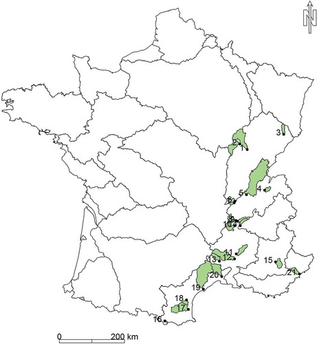
Table A1. Synthesis of withdrawable water volume studies. WB: water balance method; R: reconstitution method; E: extension method; N: neighbourhood method