
 ?Mathematical formulae have been encoded as MathML and are displayed in this HTML version using MathJax in order to improve their display. Uncheck the box to turn MathJax off. This feature requires Javascript. Click on a formula to zoom.
ABSTRACT
Quantification of the isotope altitude effect from precipitation allows the identification of recharge altitudes in high-relief areas. However, steep terrains frequently limit the use of this precipitation-based approach. Perennial rivers often provide easy, year-round access for water sampling. However, in high-relief regions rivers may not adequately represent regional precipitation isotope patterns because they integrate isotope signals along their course. This prevents the calculation of an altitudinal isotope gradient from river water samples alone. We present a study that shows how a river-based sampling approach served to determine the altitude effect. Replacing the original sample site altitude with the mean upstream catchment elevation as calculated from a digital elevation model allowed us to establish a plausible altitude isotope effect from stream water. The correction approach was verified independently using precipitation isotope data. This approach can potentially be transferred to other regions where precipitation sampling at various elevations is difficult to determine.
Editor A. Castellarin Associate Editor D. Penna
1 Introduction
Quantification of the isotope altitude effect in precipitation allows for the identification and prediction of groundwater recharge areas in mountainous watersheds. The identification of the mean catchment recharge altitude based on δ18O and δ2H measurements of water lead to a better understanding of spatial and temporal freshwater availability in the region of interest (Gat and Dansgaard Citation1972, Gonfiantini et al. Citation2001, Smerdon et al. Citation2009, Koeniger et al. Citation2016, Penna et al. Citation2017). Such knowledge contributes to the protection and sustainable use of valuable drinking water resources, in particular with respect to ongoing climate change (Reckerth et al. Citation2017, Marchina et al. Citation2020a). This is especially important in high mountain headwater catchments of the Mediterranean region in summer, during which increased demand from tourism overlaps with annual lows of precipitation. For instance, tourist numbers in the European Mediterranean region increased from 139 million in 2000 to 267 million in 2017 (UNWTO Citation2018). These numbers are expected to increase even more in the near future. The determination of recharge altitudes is therefore crucial to understand and quantify aquifer recharge in order to ensure future freshwater supply, particularly in Mediterranean islands and coastal areas (Viola et al. Citation2014, Santoni et al. Citation2018). For instance, in a study on the mountainous Mediterranean island of Corsica (France), Erostate et al. (Citation2018) applied stable isotope measurements to identify two different potential recharge areas of a low-land coastal aquifer near the city of Bastia in northeastern Corsica. In another study from the Eastern Mediterranean, Koeniger et al. (Citation2017) demonstrated the importance of the isotope altitude effect by outlining protection zones along the mean recharge altitudes of the major water resource for the city of Beirut (Lebanon).
River water and spring water are often assumed to be valid alternatives to precipitation collection because they carry an integrated isotope signal of upstream water compartments and precipitation. At first glance, these waters should therefore reflect the isotope shift in precipitation caused mainly by temperature changes along the steep relief, i.e. the isotope altitude effect. While the isotope altitude effect is usually determined directly from precipitation (D’Alessandro et al. Citation2004, Koeniger et al. Citation2017), springs (Bono et al. Citation2005) and stream waters (Kendall and Coplen Citation2001, Yao et al. Citation2009, Wen et al. Citation2012, van Geldern et al. Citation2014, Kuang et al. Citation2019) have also been used as precipitation proxies. Springs often offer meaningful estimates of regional precipitation. However, rivers in particular in high-relief regions may not adequately represent regional precipitation patterns because they integrate isotope signals from various subcatchments with variable elevation distributions along their course. The resulting local offset between river water and precipitation is referred to as the “catchment effect” (Dutton et al. Citation2005). On the one hand, placing precipitation collectors along steep profiles in high-relief catchments is often demanding in terms of field logistics and due to the number of stations that need to be maintained. Perennial rivers, on the other hand, often provide easier, year-round access for water sampling. Thus, a crucial challenge is to correctly quantify the isotope altitude effect from river waters.
Altitude effects in the Mediterranean were subject to a variety of studies, and published values for δ18O gradients range from −0.12 to −0.28‰ per 100 m increase in elevation (Celle-Jeanton et al. Citation2001, Poage and Chamberlain Citation2001, Longinelli and Selmo Citation2003, Bono et al. Citation2005, Ladouche et al. Citation2009, Liotta et al. Citation2013, van Geldern et al. Citation2014). Some of these studies use river or spring water instead of precipitation to determine the altitude effect. Because of the above limitations, the validity of this approach remains to be tested.
The main objective of this study is to test how rivers in such high-relief areas can be used as an alternative proxy to precipitation sampling. For this purpose, we will address the following questions:
To what extent do river water isotope profiles change with respect to season and discharge events?
How does the altitude isotope gradient change if sampling elevation is replaced by the mean subcatchment elevation?
Can this correction approach for river water isotope data be verified directly by comparison to local precipitation data?
In this context, the island of Corsica (France) located in the Western Mediterranean appears well suited for a river-based approach to characterize altitude effects of precipitation in high-relief areas because of its exceptionally steep topographic gradients with altitudes up to >2500 m above sea level (m a.s.l.).
2 Methods
2.1 Study area
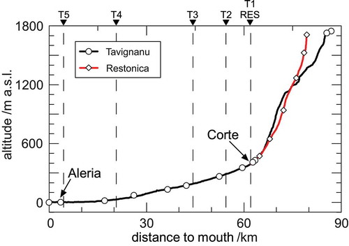
The Tavignanu catchment is located on the island of Corsica (France) in the Mediterranean Sea (). The island of Corsica covers an area of 8680 km2. A north–south orientated mountain ridge, with the highest summit at 2706 m a.s.l., dominates its topography. The Tavignanu catchment is the second largest catchment of the island with an area of 806 km2 (). The river has a total length of 87 km before it drains into the Mediterranean Sea. This short flow length and the high elevation of the upper reaches, above 1740 m a.s.l., results in a remarkably steep mean downhill gradient of about 20 m per km river length.
Figure 1. Inset: Location of Corsica in the Western Mediterranean. Map: Hillshade of the Tavignanu catchment. Sampling points are indicated for the Tavignanu (circles), the Restonica (diamonds), and tributaries (squares). Subcatchment boundaries are indicated with dashed lines
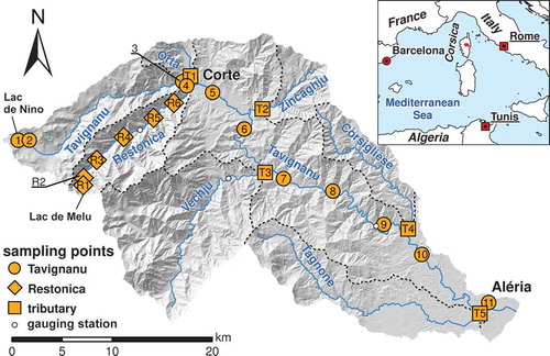
The Tavignanu River has two major headstreams of similar length (), namely the Tavignanu River and the Restonica River, that meet at the city of Corte (450 m a.s.l.). Both flow in a granitic basement and are fed by glacially formed source lakes, Lac de Nino (1743 m a.s.l.; site 1 in ) and Lac de Melu (1710 m a.s.l.; site R1). Downstream of the city of Corte, the Tavignanu River flows in a schist formation before reaching a sedimentary plain for the last 15 km and finally reaching its river mouth.
Figure 2. River profiles and sampling point locations of the Tavignanu (black) and Restonica (red) rivers. Downward-pointing triangles and dashed lines indicate tributary junctions. RES: confluence of Restonica and Tavignanu rivers at Corte
2.2 Field sampling
Samples were collected every 3 months during five field campaigns, starting in February 2016. This sampling scheme covered all seasons. A total of 23 sampling points were visited regularly in the Tavignanu catchment (). Eleven sampling points were located along the Tavignanu River course (sites 1–11 in ), whereas sampling point 3 was added later in the study, in October 2016, to search for anthropogenic impacts on downstream sites located in the city of Corte. Additionally, water from six major tributaries was sampled at an additional 11 points (R1–R6 and T1–T5 in ). A special focus was placed on the Restonica River (R1–R6), which is the first large water contributor to the Tavignanu River. In terms of accessibility, the remoteness of the upper Tavignanu River prohibited a regular sampling point distribution for this part because its valley is only accessible by foot.
The upstream sampling points of the Tavignanu (site no. 1) and the Restonica (R1) rivers were placed at the outlets of their corresponding source lakes. In addition, the tributaries T1–T5 were sampled shortly after their confluences to the main river. This offered a representative and integral sampling point for each subcatchment (). The sampling sites along the Tavignanu main course were set far enough downstream of the tributary inflows to ensure a sufficient mixture of the two water masses.
Samples for the oxygen and hydrogen isotope composition of the river water were collected from the middle of the stream and placed in 12-mL amber glass vials that were sealed with plastic caps and butyl rubber (BR)/polytetrafluoroethylene (PTFE) septa. The septa were placed with the BR side facing towards the sample to improve airtightness. In addition, sample containers were sealed with Parafilm® and stored at ~4°C and in the dark until analysis. Physico-chemical field parameters such as electric conductivity (EC) and temperature were measured with a WTW Multi 350i multiparameter instrument (WTW GmbH, Weilheim, Germany).
2.3 Local precipitation
Recently, a network for isotopes in precipitation has been established for several sites on the island of Corsica (Huneau et al. Citation2015). Monthly precipitation was collected at Aleria (17 m a.s.l.) and Corte (450 m a.s.l.) using oil-free Palmex® rain collectors (Palmex d.o.o., Zagreb, Croatia) that effectively prevent evaporative isotopic enrichment (Michelsen et al. Citation2018) and was analysed for oxygen and hydrogen isotope ratios. From these values, local meteoric water lines (LMWLs) were calculated using a precipitation amount weighted least squares regression (PWLSR) according to Hughes and Crawford (Citation2012). This method was preferred over the conventional ordinary least squares regression (OLSR) to avoid a bias towards small amounts of summer precipitation. Additionally, precipitation-weighted LMWLs are favourable here, because they better reflect the average recharge and thus the overall contribution to the water budget. This is especially true for coastal, island, and Mediterranean locations (Crawford et al. Citation2014). Note that a discussion about the most appropriate regression method is still ongoing in the scientific literature (Krajcar Bronić et al. Citation2020, Marchina et al. Citation2020b).
2.4 Stable isotopes of oxygen and hydrogen
The oxygen (δ18O) and hydrogen (δ2H) stable isotope compositions were analysed with an isotope ratio infrared spectroscopy (IRIS) analyser, based on wavelength-scanned cavity ring-down spectroscopy (L 1102-i WS-CRDS, Picarro Inc., Santa Clara, CA, USA). All values are reported in the standard δ-notation in per mille (‰) vs. Vienna Standard Mean Ocean Water (VSMOW) according to
where R is the ratio of the numbers (n) of the heavy and light isotope of an element (e.g. n(18O)/n(16O)) in the sample and the reference (Coplen Citation2011). These results are multiplied by 1000 to express them in per mille (‰).
Four sequential injections of each sample were measured, and raw data were corrected for sample-to-sample memory effects. The reported value is the mean value. Data were corrected for instrumental drift during the run and normalized to the VSMOW/SLAP (Standard Light Antarctic Precipitation) scale by assigning a value of 0‰ and –55.5‰ (δ18O)/0‰ and –427.5‰ (δ2H) to VSMOW2 and SLAP2, respectively (Brand et al. Citation2014). For normalization, two laboratory-internal reference materials, which were calibrated directly against VSMOW2 and SLAP2, were measured in each run. External reproducibility based on repeated analyses of a control sample was 0.05‰ and 0.5‰ (±1 σ) for δ18O and δ2H. For a detailed description of the analytical procedure refer to van Geldern and Barth (Citation2012).
2.5 Spatial analyses with geographic information system (GIS)
Spatial analyses were performed on a 10-m digital elevation model (DEM) that was processed with ArcMap 10.4.1 (Esri, Redlands, CA, USA). Streams were generated by calculating a flow-direction and flow-accumulation raster, after smoothing the DEM with the elevation void fill function. Subsequently, streams were defined by exceeding a flow-accumulation raster value threshold of 20 000. This procedure produced a river network that was almost identical to the official topographic map. After establishing a river network in this manner, subcatchments were delineated with the watershed tool using corresponding sampling point locations and river junctions as outlets. The “Locate-Features-along-Route-tool” was used to extract distance to mouth (dtm) values along the sampled streams. Subcatchment mean elevations were calculated as the mean value of the DEM with the “zonal statistics” tool.
3 Results and discussion
3.1 Seasonal and spatial and isotope patterns
As expected, oxygen (δ18O) and hydrogen (δ2H) isotope values of river water showed a strong linear correlation (r2 = 0.94). Therefore, only δ18O values are described and discussed here; however, findings and conclusions apply analogously to δ2H. All δ18O and δ2H analytical results are presented in and the online supplementary material (Table S1).
Figure 3. Dual isotope plot of river water and source lake samples (sites R1 and T1). For annual weighted (an. wt.) mean of precipitation from Corte and Aleria, refer to . The dashed line is the Western Mediterranean meteoric water line (WMMWL) of Celle-Jeanton et al. (Citation2001). δP is the intersection of the local evaporation line (LEL) and the WMMWL. VSMOW–Vienna Standard Mean Ocean Water
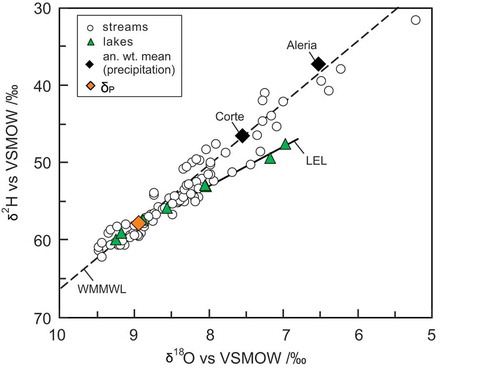
The δ18O values at the two source lake outlets of Lac de Nino (site 1) and Lac de Melu (site R1) ranged from between −9.3 and −9.2‰ in February to between −7.0 and −8.0‰ in July (, Table S1). Compared to values that were measured farther downstream along the Tavignanu River course (site 2), Lac de Nino values were relatively enriched in δ18O and δ2H. This enrichment of the lake water with respect the stream water was strongest in the warm season during July and October with δ18O differences of 1.9 and 1.0‰, but less pronounced with changes of 0.2 and 0.3‰ in February and May during the cold season. In the Restonica headwaters downstream of Lac de Melu, this relative enrichment of the lake water was also clearly visible in July, during the warm season. Accordingly, lake waters show a clear evaporative signal as a result of water loss from the lake surface. The isotope signal of the source lakes was used to construct the local evaporation line (LEL) ().
Figure 4. δ18O values of river water samples versus sampling site altitude. Seasons are colour coded, whereas shapes identify tributaries and rivers. VSMOW–Vienna Standard Mean Ocean Water
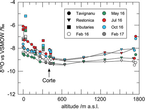
Until the confluence between Restonica and Tavignanu, δ18O values of the Restonica waters typically decreased along the river course (sites R2–R6) in May, July, and October. Corresponding differences between source lake waters (R1) and the last sampling site before the confluence with the Tavignanu (site R6) were −0.5, −0.5 and −0.7‰, respectively (). For the sampling campaign in February 2016, no such trend could be observed, and river water values remained stable along the Restonica River course.
Downstream of the confluence between the Tavignanu and the Restonica rivers at an elevation of 450 m a.s.l., δ18O values gradually increased, with increments between +0.6 and +1.3‰ (sites 5–11). Note that the lowermost sampling point (site 11) before the Tavignanu enters the sea was affected by seawater during July and October due to baseflow conditions and tidal effects. The seawater contribution was indicated by elevated EC values. This influence caused isotope changes that were related not to altitude effects but to seawater mixing, and therefore these two measurements are not further considered in this study (cf. Table S1).
Seasonal variability of isotope values in rivers can be further modulated by storm events or snow melt. Daily discharge values of the Tavignanu, Restonica and Vechju rivers were recorded at automated gauging stations (). Monthly discharge means (20-year average) for the Tavignanu River range between 11.2 and 16.2 m3 s–1 from November to May and decrease to a summer low of 0.9–1.9 m3 s–1 from July to September. July and October means have intermediate values of 5.2 and 4.8 m3 s–1, representing a transitional phase between summer low and winter to spring high discharges.
Figure 5. Discharge of rivers, with indications of seasonal sampling campaigns. See for locations of gauging stations. Logarithmic scale is to cover flooding events
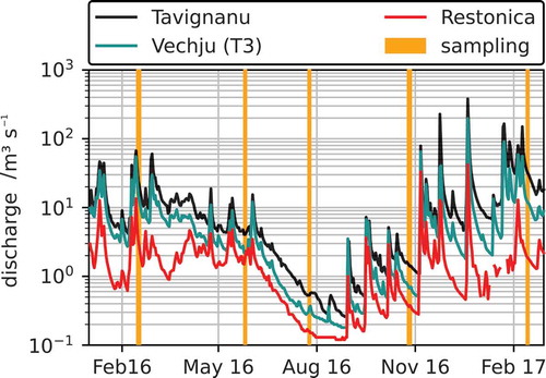
Ten extreme discharge events above 150 m3 s–1 were recorded for the period between July 1996 and June 2017. Four of these events fall in the sampling period between November 2016 and February 2017. Among these, the highest recorded discharge was 380 m3 s–1 on 20 December 2016. Values for the other three events (within the 10 largest discharge events) are 228, 165, and 150 m3 s–1.
Sampling campaigns in May, July and October 2016 were performed during discharge conditions that are representative of the long-term average discharge of the respective season. On the other hand, both February sampling campaigns in 2016 and 2017 were performed along the ring-downs of discharge event peaks. However, stable isotope patterns along river courses of both winter sampling campaigns did not reveal anomalous patterns. The overall shape closely follows the isotopic patterns of spring, summer, and autumn samplings (). In general, February and May isotope curves plot at lower values due to lower temperatures and potential snow melt influences in spring time. July and October curves are characterized by higher isotope values. Note that the overall shape of the rivers’ isotope profiles is repeated in each season. In February 2017 the higher altitude sections were not accessible due to the road conditions, and these values are therefore absent from .
3.2 Apparent inverse altitude effect
Starting from sea level, the isotope values became progressively lower with increasing altitude along the river profile until the confluence of the Restonica and the Tavignanu at 450 m a.s.l. (). This negative correlation between river water isotope values and elevation corresponds to the expected altitude effect of precipitation (Siegenthaler and Oeschger Citation1980, Kern et al. Citation2014, Clark Citation2015).
However, upstream of this confluence, this trend was inverted during the May, July, and October campaigns, and we found increasing isotope values in the river water with increasing altitude (). This positive correlation between isotope values and elevation, an apparent inverse altitude effect, opposes the expected trend for input signals of precipitation that feeds the river water by surface runoff or by rapid flow through shallow subsurface flowpaths. During the February 2016 sampling campaign, we found stagnating stable isotope values in the river water upstream of 450 m a.s.l. These observations were also not in line with the expected decreasing values with increasing altitude.
It is well known that an “inverse” isotope effect in precipitation with positive elevation gradient can occur (Niewodnizański et al. Citation1981, Moran et al. Citation2007, Pang et al. Citation2011, Kong and Pang Citation2016, Jiao et al. Citation2019). The main reason for this inverse effect is mixing of moisture from different vapor sources at these higher altitudes. It occurs at higher elevations on the leeward side of a high mountain chain after the over peak air flow. Such inverse gradients often strongly depend on local weather conditions that control the local vapor cycle with respect to moisture recycling and subcloud evaporation, which thus can cause an inverse isotope effect (see Jiao et al. Citation2019). However, such an effect should be restricted to specific weather conditions during seasons with prevailing conditions for wind and moisture transport. This was not the case according to our observation, as the overall isotope profile along the river course did not change with the season. Moreover, river water will not only reflect the most recent precipitation event but will integrate the precipitation isotope signal in space and time (Kendall and Coplen Citation2001). Consequently, short-term weather conditions that might cause very special conditions, including an inverse isotope effect in precipitation events, should be damped or even removed in river water.
Another complexity results from the fact that both rivers, the Restonica and the Tavignanu, are fed by glacial source lakes. Prior to their respective outflows, both lakes are subject to evaporation effects that preferentially enrich the lake water in the heavy 18O and 2H isotopes. The amplitude of this evaporation effect depends on the season, with the strongest effect occurring during the warm season in July and August.
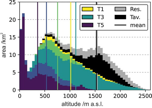
At first sight, one might conclude that reconstructing the altitude effect via river water samples may not be possible because of unknown secondary alterations of the pristine precipitation isotope value before it eventually enters the river. However, when considering the area distribution of different elevations (), a correction approach that allows for reconstructing the isotope altitude effect from river water data seems plausible. Most of the area in the headwaters of the Restonica and the Tavignanu rivers is located between 1200 and 2000 m a.s.l. (). This causes disproportionately larger contributions of precipitation to the river from this elevation span. As a result, isotope values of river water at a specific sampling site are lower than the corresponding precipitation isotope value at the same altitude (“catchment effect”). The reason is the integration of the isotope signal along the river course, which thus represents the elevation of the mean recharge area and not the sampling site elevation. This demands a deeper examination of the available regional and local precipitation isotope data.
Figure 6. Elevation histogram for Restonica (Res.), Tavignanu (Tav.) and tributary subcatchments upstream from confluence
3.3 Local precipitation and lake evaporation patterns
The regional Western Mediterranean meteoric water line (WMMWL) for our study region was established by Celle-Jeanton et al. (Citation2001) as follows:
The slopes of the two LMWLs for Aleria (7.64 ± 0.44) and Corte (7.56 ± 0.50) calculated by PWLSR are in close agreement with the WMMWL. An advantage of the WMMWL is that it is based on a longer observation period than the currently available local data. Therefore, the WMMWL is assumed to sufficiently describe the isotope range of precipitation input on the catchment scale.
The regression through the isotope values of the seasonal samples taken from the two source lake outlets of the Tavignanu (1) and the Restonica (R1) produce a significantly lower slope when compared to the WMMWL (Celle-Jeanton et al. Citation2001). This regression describes the LEL according to the following equation:
The slope matches the generally accepted slopes for LELs, which typically range from 4 to 6 (Edwards et al. Citation2004, Gibson et al. Citation2008, Citation2016).
The intercept of the LEL and the WMMWL, denoted as δP, with values of −8.9‰ (δ18O) and −58‰ (δ2H), can serve as a proxy for the mean annual precipitation at the corresponding altitude of around 1700 m a.s.l. (Gibson et al. Citation1993). This is particularly useful because no precipitation data were available above 500 m a.s.l. Therefore, a δP value constructed in this manner yields an independent validation for testing the proposed correction method described below.
3.4 Correction of isotope values by mean catchment elevations
In an attempt to correct for the spatial distribution of elevation, all sampling points at the outflow of subcatchments, namely the tributary sampling points (T1–T5) and the sampling points of the Tavignanu (site 4) and Restonica (R6) located just upstream from Corte, were evaluated against the mean upstream catchment elevation ().
The upstream Restonica sampling sites R1 to R5 were not included because of the strong evaporation influence of the source lake water (). This evaporative signal is supposed to be lost with the addition of non-evaporated surface and groundwater water, which enters the stream through fissures and joints in the granitic rock, along the stream up to sampling point R6. Therefore, site R6 best represents the entire Restonica subcatchment. The same logic applies to sampling site 4, which best represents the upper Tavignanu subcatchment. In addition, samples of the Tavignanu River downstream of Corte were excluded from the correction procedure to avoid the multiple integration of upstream subcatchments.
The mean upstream catchment elevation replaces the original river sampling site altitude in . In other words, the measured δ-values at a specific site were shifted upwards until the elevation where the average river water originated from ().
Figure 7. δ18O values versus mean catchment elevation upstream from the respective sampling points for the Tavignanu, Restonica and tributaries. The dashed line is the ordinary least squares regression (OSLR) of the altitude-corrected river water isotope values with 95% confidence interval (CI). Weighted annual means of precipitation at Aleria and Corte (black diamonds) and the intercept (δP) of the WMMWL and the LEL (white diamond) were added as independent comparative values
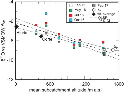
After correcting for the altitude in this manner, the resulting slope of the regression that defines the altitude effect of river samples is described by (−0.19 ± 0.02)‰/100 m (r2 = 0.68, n = 35). Uncertainty is reported as the standard error (SE).
Weighted annual precipitation means for Aleria, Corte and δP were added to as independent validation values (). Note that these independent values were derived from monthly precipitation collection (Aleria, Corte) and the LEL/WMMWL intercept (δP) and should therefore directly represent the altitude effect in precipitation. These data points were not corrected in any manner and are used here to confirm our model-derived correction approach for river water. The direct comparison of precipitation isotope values and the OLSR of the corrected tributary isotope values shows that they overlap within (Aleria, δP) and along (Corte) the boundaries of the 95% confidence interval (CI) for the OLSR through the river water data (). A linear regression of these three independent data points yields a slightly lower slope of −0.14‰/100 m for the altitudinal gradient compared to the river water-derived slope. Note, however, that this value is within the 2-SE uncertainty. We therefore conclude that this validates the proposed correction method using mean catchment elevations.
Table 1. Upstream mean catchment elevation calculated for the two sampling sites, just upstream of their confluence at Corte along the Restonica (R6) and the Tavignanu (4), and all tributaries (T1 to T5). See for locations
Table 2. Weighted average (wt. av.) isotope values of monthly precipitation samples at Corte and Aleria (see for locations). VSMOW–Vienna Standard Mean Ocean Water
A study from the Biguglia lagoon near Bastia in northeastern Corsica (Erostate et al. Citation2018) used stable isotope measurements of groundwater from a coastal aquifer to identify potential recharge areas. Based on a comparison with isotope precipitation data from Bastia and Corte, the authors identified two main sources for recharge: while the southern part of the aquifer is recharged by local precipitation, the northern part is characterized by significantly depleted stable isotope values that indicate a “higher-altitude water source.” However, in their study it was not possible to further narrow down the recharge altitude within the catchment. The δ18O values of groundwater at the Biguglia lagoon ranged between −8.0 and −9.1‰. By applying the altitudinal isotope gradient for Corsica from this study, these values translate into mean recharge altitudes of 1000 to 1500 m a.s.l. Compared to the values in the literature, the value of (−0.19 ± 0.02)‰ for δ18O determined using the geographic information system (GIS) correction approach of this study falls within the interval of −0.12 to −0.28‰ per 100 m reported for the Mediterranean (see above). The European mean of −0.21‰ per 100 m, established by Poage and Chamberlain (Citation2001), is also within ±1 SE of the calculated value for the Tavignanu Catchment. This also accounts for the value of (–0.17 ± 0.02) calculated for stream and spring waters in Corsica by van Geldern et al. (Citation2014).
3.5 Limitations
In the high-relief area of this study, our approach was able to compensate for the accumulation of the stream signal by establishing a mean elevation of the upstream catchment area. However, this approach may also have its limitations. When applying this technique, one must keep in mind that isotope values of surface waters may not always adequately represent upstream precipitation, particularly if river water contributions depend on specific climatic, hydrological, and hydrogeological conditions.
Our correction approach assumes an equal spatial distribution of precipitation in the catchment. This is not always a valid assumption for high-relief terrains because of generally increased precipitation amounts at higher elevations. Nevertheless, our data show that elevation-corrected river isotope values agree well with measured precipitation isotope values. We presume that this relates to the small subcatchment size of our study site, that does not allow for a large spatial variability of precipitation amounts. This might limit the transferability of our approach to larger catchment sizes with less homogeneous precipitation distribution patterns.
One must also assume that secondary evaporation after precipitation is almost negligible. This should be valid for regions where geology and climate allow precipitation to infiltrate the ground quickly after rain events. Under such conditions, recharge of the rivers should occur via short-distance surface runoff or shallow subsurface flow. These conditions are met in our study area, and secondary evaporative enrichment in the high-altitude source lakes should not affect the sampling locations that were used in our correction approach (see above).
Finally, we must assume that groundwater-surface water interactions leave the isotope signal of the stream unchanged. Significant groundwater contributions from large underground water bodies, as for instance in karst areas, from paleo-water aquifers or geothermal reservoirs with differing isotope compositions, might significantly shift the river water isotope composition with respect to regional precipitation.
4 Conclusions
The stable isotope analyses of water sampled from a perennial river in a high-relief region, over its entire course from its high-elevation source lakes down to sea level, coupled with isotope data from local rainfall allowed for the development, testing, and verification of a GIS-based elevation correction approach. This approach correctly determined the isotope altitude gradient that is important for identifying recharge areas and altitudes that feed low-land aquifers, which are vital drinking water resources. To our knowledge, the direct comparison of river water data with precipitation isotopes is new for a catchment with such a considerable altitudinal gradient.
When considering river water isotope ratios with associated sampling elevations in the Tavignanu Catchment, we were unable to construct a plausible altitude effect for the upstream catchment above 450 m a.s.l. An inverse isotope effect, as described in the literature for precipitation (e.g. Jiao et al. Citation2019), seemed unreasonable regarding the rather stable isotope pattern along the river course during all seasons. However, replacing the sampling site elevation with the calculated mean upstream catchment elevation yielded a valid linear altitude isotope effect from stream water with a good coefficient of determination. The calculated slope was verified from independent precipitation isotope measurements that were directly collected in the study area. In addition, it corresponds well with the literature values for the region. Nonetheless, precipitation data should always be favoured because they minimize environmental alterations.
One major advantage of the approach presented in this study is that collection of river water is logistically more feasible than regular precipitation sampling, which may become labour-intensive and more challenging in remote regions. Such correction of river water data may also offer a valuable opportunity in places where no stable isotope values from precipitation have been measured and data from the Global Network of Isotopes in Precipitation (GNIP) (IAEA/WMO Citation2021) are sparse. Further, a river-based approach delivers integrated data for the entire catchment area instead of isolated precipitation data points. This might prove more useful to quantify regional groundwater recharge, as it is not prone to statistical outliers (Kendall and Coplen Citation2001).
A sound knowledge of the isotope altitude gradient becomes increasingly crucial to protect areas where main recharge for drinking water purposes occurs. The approach presented in this study should be transferable to other high-relief regions to allow easier and meaningful determination of the precipitation altitude effect based on river water measurements. Further studies that involve sampling rainfall and river data at different altitudes could confirm our technique and would help to provide better validation.
Supplemental Material
Download PDF (209.5 KB)Acknowledgements
We thank Christian Hanke, Irene Wein, Silke Meyer, and Lucy Beinert (Erlangen), who helped with field work and laboratory analyses.
Data availability statement
The authors confirm that the data supporting the findings of this study are available within the article and its supplementary materials.
Disclosure statement
No potential conflict of interest was reported by the authors.
Supplementary material
Supplemental data for this article can be accessed here.
Additional information
Funding
Related Research Data
References
- Bono, P., et al., 2005. Stable isotopes (δ18O, δ2H) and tritium in precipitation: results and comparison with groundwater perched aquifers in Central Italy. In: IAEA, eds. Isotopic composition of precipitation in the Mediterranean Basin in relation to air circulation patterns and climate. IAEA-TECDOC-1453. Vienna: International Atomic Energy Agency, 115–124.
- Brand, W.A., et al., 2014. Assessment of international reference materials for isotope-ratio analysis (IUPAC technical report). Pure and Applied Chemistry, 86 (3), 263–467. doi:10.1515/pac-2013-1023.
- Celle-Jeanton, H., Travi, Y., and Blavoux, B., 2001. Isotopic typology of the precipitation in the Western Mediterranean region at three different time scales. Geophysical Research Letters, 28, 1215–1218. doi:10.1029/2000GL012407
- Clark, I., 2015. Groundwater geochemistry and isotopes. 1st ed. Boca Raton: CRC Press.
- Coplen, T.B., 2011. Guidelines and recommended terms for expression of stable-isotope-ratio and gas-ratio measurement results. Rapid Communications in Mass Spectrometry, 25 (17), 2538–2560. doi:10.1002/rcm.5129.
- Crawford, J., Hughes, C.E., and Lykoudis, S., 2014. Alternative least squares methods for determining the meteoric water line, demonstrated using GNIP data. Journal of Hydrology, 519, 2331–2340. doi:10.1016/j.jhydrol.2014.10.033
- D’Alessandro, W., et al., 2004. Oxygen isotope composition of natural waters in the Mt Etna area. Journal of Hydrology, 296 (1–4), 282–299. doi:10.1016/j.jhydrol.2004.04.002.
- Dutton, A., et al., 2005. Spatial distribution and seasonal variation in 18O/16O of modern precipitation and river water across the conterminous USA. Hydrological Processes, 19 (20), 4121–4146. doi:10.1002/hyp.5876.
- Edwards, T.W.D., et al., 2004. Use of water isotope tracers in high latitude hydrology and paleohydrology. In: R. Pienitz, M.S.V. Douglas, and J.P. Smol, eds. Long-term environmental change in Arctic and Antarctic Lakes. Dordrecht, The Netherlands: Springer, 187–207.
- Erostate, M., et al., 2018. Delayed nitrate dispersion within a coastal aquifer provides constraints on land-use evolution and nitrate contamination in the past. Science of the Total Environment, 644, 928–940. doi:10.1016/j.scitotenv.2018.06.375.
- Gat, J.R. and Dansgaard, W., 1972. Stable isotope survey of the fresh water occurrences in Israel and the Northern Jordan Rift Valley. Journal of Hydrology, 16 (3), 177–211. doi:10.1016/0022-1694(72)90052-2.
- Gibson, J.J., et al., 1993. Estimating evaporation using stable isotopes: quantitative results and sensitivity analysis for two catchments in Northern Canada. Hydrology Research, 24 (2–3), 79. doi:10.2166/nh.1993.0015.
- Gibson, J.J., Birks, S.J., and Edwards, T.W.D., 2008. Global prediction of δA and δ2H-δ18O evaporation slopes for lakes and soil water accounting for seasonality. Global Biogeochemical Cycles, 22, GB2031. doi:10.1029/2007GB002997
- Gibson, J.J., Birks, S.J., and Yi, Y., 2016. Stable isotope mass balance of lakes: a contemporary perspective. Quaternary Science Reviews, 131, 316–328. doi:10.1016/j.quascirev.2015.04.013
- Gonfiantini, R., et al., 2001. The altitude effect on the isotopic composition of tropical rains. Chemical Geology, 181 (1), 147–167. doi:10.1016/S0009-2541(01)00279-0.
- Hughes, C.E. and Crawford, J., 2012. A new precipitation weighted method for determining the meteoric water line for hydrological applications demonstrated using Australian and global GNIP data. Journal of Hydrology, 464–465, 344–351. doi:10.1016/j.jhydrol.2012.07.029
- Huneau, F., et al., 2015. A new network for isotopes in precipitation of Corsica (France). Abstracts of the International Symposium on Isotope Hydrology: Revisiting Foundations and Exploring Frontiers. Vienna, Austria: International Atomic Energy Agency (IAEA).
- IAEA/WMO, 2021. Global network of isotopes in precipitation. The GNIP database [online]. Available from: http://www-naweb.iaea.org/napc/ih/IHS_resources_gnip.html [Accessed 31 January 2021].
- Jiao, Y., et al., 2019. Impacts of moisture sources on the isotopic inverse altitude effect and amount of precipitation in the Hani Rice Terraces region of the Ailao Mountains. Science of the Total Environment, 687, 470–478. doi:10.1016/j.scitotenv.2019.05.426.
- Kendall, C. and Coplen, T.B., 2001. Distribuntion of oxygen-18 and deuterium in river waters across the United States. Hydrological Processes, 15, 1363–1393. doi:10.1002/hyp.217
- Kern, Z., Kohán, B., and Leuenberger, M., 2014. Precipitation isoscape of high reliefs: interpolation scheme designed and tested for monthly resolved precipitation oxygen isotope records of an Alpine domain. Atmospheric Chemistry and Physics, 14 (4), 1897–1907. doi:10.5194/acp-14-1897-2014.
- Koeniger, P., et al., 2017. Stable isotope‐based mean catchment altitudes of springs in the Lebanon Mountains. Hydrological Processes, 31 (21), 3708–3718. doi:10.1002/hyp.11291.
- Koeniger, P., Toll, M., and Himmelsbach, T., 2016. Stable isotopes of precipitation and spring waters reveal an altitude effect in the Anti‐Lebanon Mountains, Syria. Hydrological Processes, 30 (16), 2851–2860. doi:10.1002/hyp.10822.
- Kong, Y. and Pang, Z., 2016. A positive altitude gradient of isotopes in the precipitation over the Tianshan Mountains: effects of moisture recycling and sub-cloud evaporation. Journal of Hydrology, 542, 222–230. doi:10.1016/j.jhydrol.2016.09.007
- Krajcar Bronić, I., et al., 2020. Isotope composition of precipitation, groundwater, and surface and lake waters from the Plitvice Lakes, Croatia. Water, 12, 9. doi:10.3390/w12092414.
- Kuang, X., et al., 2019. Using stable isotopes of surface water and groundwater to quantify moisture sources across the Yellow River source region. Hydrological Processes, 33 (13), 1835–1850.
- Ladouche, B., Luc, A., and Nathalie, D., 2009. Chemical and isotopic investigation of rainwater in Southern France (1996–2002): potential use as input signal for karst functioning investigation. Journal of Hydrology, 367 (1–2), 150–164. doi:10.1016/j.jhydrol.2009.01.012.
- Liotta, M., et al., 2013. Isotopic composition of precipitation and groundwater in Sicily, Italy. Applied Geochemistry, 34, 199–206. doi:10.1016/j.apgeochem.2013.03.012.
- Longinelli, A. and Selmo, E., 2003. Isotopic composition of precipitation in Italy: a first overall map. Journal of Hydrology, 270 (1–2), 75–88. doi:10.1016/S0022-1694(02)00281-0.
- Marchina, C., et al., 2020a. Headwaters’ isotopic signature as a tracer of stream origins and climatic anomalies: evidence from the Italian Alps in Summer 2018. Water, 12 (2), 390. doi:10.3390/w12020390.
- Marchina, C., et al., 2020b. Alternative methods to determine the δ2H-δ18O relationship: an application to different water types. Journal of Hydrology, 587, 124951. doi:10.1016/j.jhydrol.2020.124951.
- Michelsen, N., et al., 2018. Comparison of precipitation collectors used in isotope hydrology. Chemical Geology, 488, 171–179. doi:10.1016/j.chemgeo.2018.04.032.
- Moran, T.A., et al., 2007. Altitudinal gradients of stable isotopes in Lee-Slope precipitation in the Canadian Rocky Mountains. Arctic, Antarctic, and Alpine Research, 39 (3), 455–467. doi:10.1657/1523-0430(06-022)[MORAN]2.0.CO;2.
- Niewodnizański, J., et al., 1981. The altitude effect on the isotopic composition of snow in high mountains. Journal of Glaciology, 27 (95), 99–111. doi:10.1017/S0022143000011266.
- Pang, Z., et al., 2011. Processes affecting isotopes in precipitation of an arid region. Tellus B: Chemical and Physical Meteorology, 63 (3), 352–359. doi:10.1111/j.1600-0889.2011.00532.x.
- Penna, D., et al., 2017. Response time and water origin in a steep nested catchment in the Italian Dolomites. Hydrological Processes, 31 (4), 768–782. doi:10.1002/hyp.11050.
- Poage, M.A. and Chamberlain, C.P., 2001. Empirical relationships between elevation and the stable isotope composition of precipitation and surface waters: considerations for studies of paleoelevation change. American Journal of Science, 301 (1), 1–15. doi:10.2475/ajs.301.1.1.
- Reckerth, A., et al., 2017. Long-term data set analysis of stable isotopic composition in German rivers. Journal of Hydrology, 552, 718–731. doi:10.1016/j.jhydrol.2017.07.022.
- Santoni, S., et al., 2018. Multiple recharge processes to heterogeneous Mediterranean coastal aquifers and implications on recharge rates evolution in time. Journal of Hydrology, 559, 669–683. doi:10.1016/j.jhydrol.2018.02.068.
- Siegenthaler, U. and Oeschger, H., 1980. Correlation of 18O in precipitation with temperature and altitude. Nature, 285, 314. doi:10.1038/285314a0
- Smerdon, B.D., et al., 2009. An approach for predicting groundwater recharge in mountainous watersheds. Journal of Hydrology, 365 (3), 156–172. doi:10.1016/j.jhydrol.2008.11.023.
- UNWTO, 2018. 2017 international tourism results: the highest in seven years. UNWTO World Tourism Barometer, 16 (Advance Release), 7.
- van Geldern, R., et al., 2014. Stable water isotope patterns in a climate change hotspot: the isotope hydrology framework of Corsica (western Mediterranean). Isotopes in Environmental and Health Studies, 50 (2), 184–200. doi:10.1080/10256016.2013.839559.
- van Geldern, R. and Barth, J.A.C., 2012. Optimization of instrument setup and post-run corrections for oxygen and hydrogen stable isotope measurements of water by isotope ratio infrared spectroscopy (IRIS). Limnology and Oceanography: Methods, 10, 1024–1036.
- Viola, F., et al., 2014. The state of water resources in major Mediterranean islands. Water Resources, 41 (6), 639–648. doi:10.1134/S0097807814060207.
- Wen, R., et al., 2012. The altitude effect of δ 18O in precipitation and river water in the Southern Himalayas. Chinese Science Bulletin, 57 (14), 1693–1698. doi:10.1007/s11434-012-4992-7.
- Yao, T., Zhou, H., and Yang, X., 2009. Indian monsoon influences altitude effect of δ18O in precipitation/river water on the Tibetan Plateau. Chinese Science Bulletin, 54 (16), 2724–2731.