
ABSTRACT
Yolŋu Aboriginal people’s knowledge about water (“gapu”) and its governance has strong cultural significance and meaning in East Arnhem Land Aboriginal worlds in northern Australia. This study used transdisciplinary research methods to explore the ways in which Yolŋu Aboriginal gapu and Western science hydrological knowledge can work together and contribute towards water management on Milingimbi Island, a small, resource-constrained, bedrock island. Transcending disciplinary boundaries is distinctly different to an interdisciplinary, socio-hydrological perspective, which can pose a risk to hybridizing Aboriginal knowledge and Western science. Community engagement activities and workshops were conducted as part of a three-year research project to bring together the incommensurable knowledge communities. A participatory three-dimensional mapping exercise created a shared space, facilitating an open-dialogue exchange of insight and knowledge among Aboriginal knowledge authorities, hydrologists, public servants, and academic researchers. This paper prompts readers to reconsider the ways water can be perceived and conserved in a decolonizing way.
Editor S. Archfield Associate Editor M. Haeffner
1 Introduction
Groundwater is an important freshwater source, supplying almost half of all drinking water worldwide (International Groundwater Resources Assessment Centre Citation2018). Environmental degradation and changing climatic conditions, with increases in water demand for agriculture, industry, and secure water resources, are threatening the sustainability of groundwater resources, globally. The United Nations (Citation2016) estimates that two billion people will be living with the risk of reduced access to freshwater resources by 2050, and declares “clean, accessible water for all” as one of 17 sustainable development goals to be achieved by 2030. Under such circumstances, the sustainable management of groundwater is becoming a major concern, particularly for island communities where the only water sources are fresh groundwater lenses, which are highly vulnerable to degradation from anthropogenic pollution and seawater intrusion (Falkland and Custodio Citation1991, Ferguson and Gleeson Citation2012, Werner et al. Citation2013).
Threatened by anthropogenic impacts, the management of groundwater on Aboriginal land is best approached with transdisciplinary science that engages both hydrological and Aboriginal knowledge and governance practices – not one or the other. Transdisciplinary research (as distinct from multidisciplinary or interdisciplinary research) acknowledges the legitimacy of knowledge practices at work outside the academy, for example of Aboriginal peoples, including their politics and metaphysical commitments (Christie Citation2006). While such research is not difficult to define, its practices and processes must differ radically according to the various transdisciplinary contexts in which it finds itself. Lack of engagement of the end users – the traditional owners of the water resource – leads to particular failings or lack of uptake of socio-economic projects on Aboriginal land.
The purpose of this paper is to provide a detailed case study of a long-term engagement between hydrologists, government, and Yolŋu, who are the traditional owners of Milingimbi Island, a small, resource-constrained island located off the north coast of Australia’s Northern Territory, and to discuss the processes of water management decision making and the different epistemic practices of these stakeholders and Yolŋu rightsholders. In particular, this research focuses on the Yolŋu Aboriginal landscape – the water, land, and people of Milingimbi Island – and addresses the ways in which complex Aboriginal understandings and authority over freshwater knowledge, understanding, and management can work together with Western science. Such collaboration involved bringing together (1) Western scientific knowledge, in the development of the hydrogeological conceptual model of the groundwater system and how it responds to varying hydroclimatic conditions and stresses; (2) the participatory engagement between the Yolŋu rightsholders, the traditional owners and caretakers of the island and its waters, the local ranger group, and the end users with the use of participatory three-dimensional mapping (P3DM) that created the space for dialogue; and (3) strategic planning from the utility provider, co-responsible for the operation, management, and delivery of the resource.
To deliver a robust and workable water management plan for the Milingimbi Island community, this transdisciplinary project recognizes and takes both cutting-edge hydrological science and ancestral Yolŋu water – gapu – and places Yolŋu governance authorities at the centre of a community water management plan. Taking seriously Yolŋu sovereignty over the island, and their metaphysical commitment to the authority of people–places as units, implies a “ground-up” approach (Christie Citation1994, Citation2013) which begins with the “problem” on the ground, and negotiates a solution through the very diverse contributions of various knowledge authorities. What emerges is negotiated under authority, rather than a hybrid that amalgates Yolŋu Aboriginal knowledge with Western scientific knowledge and can expose the former to a great risk of being framed and evaluated against the paradigms of the latter.
As part of this transdisciplinary research project, we explore Yolŋu understandings and governance of gapu (Section 2) before turning to a specific discussion and focused study of Milingimbi gapu (Section 3). In Section 4, we describe the historical aspects of the Milingimbi water story, then present the findings of the transdisciplinary research collaboration. Section 5 explores the implications of this research for future transdisciplinary work and the opportunities for collaborative water management by the Aboriginal ancestral and hydrological governance practices. Conclusions are provided in Section 6.
2 Yolŋu Aboriginal water – gapu
In Aboriginal Australia, the land and seascapes have been occupied by Aboriginal inhabitants for many thousands of years. They have flourished with distinctive traditions, including many pertaining to many waters and forms of water. Considering such Aboriginal ways of being and knowing is imperative for transdisciplinary research projects conducted in Aboriginal country; not only for acknowledgement and respect of Aboriginal ownership but also for their contribution to a well negotiated and workable collaborative management plan. During the first visit to the Milingimbi Island, in preparation for the physical scientific investigation, water utility providers, physical hydrologists, and social scientists attended a cultural workshop delivered by a locally established Yolŋu Aboriginal corporation. Participants were guided to various water resources on the island, so as to be immersed in Yolŋu Aboriginal ways of being and knowing gapu. In this spirit, we here invite the reader to witness one aspect of the distinctive traditional water knowledge of East Arnhem Land.
2.1 Ancestral creation of gapu
East Arnhem Land, several hundred kilometres to the east of the capital city of Darwin in the Northern Territory, Australia (), belongs to many interrelated clan groups of the Yolŋu Aboriginal people who are the owners and carers of the landscape and waters that were once provided by their ancestral beings. In the Yolŋu world, everything in the sky and the water, and on the ground (e.g. the evening star, barramundi fish, the ironwood tree, mosquitoes, breezes, clouds) are all the result of the creational work of their ancestors. This Yolŋu world is divided into two moieties: Dhuwa and Yirritja. Dhuwa people have Dhuwa languages, Dhuwa totems, Dhuwa clan groups, Dhuwa lands and waters, and Dhuwa songs and ceremonies. Likewise, that is the case for Yirritja people. Dhuwa women marry Yirritja men and bear Yirritja children. Yirritja women marry Dhuwa men and have Dhuwa children. That is how the world continues coming to life. Dhuwa groups and individuals, as children of their Yirritja mothers, are the supervisors and managers (djuŋgaya) of all Yirritja business. Yirritja are djuŋgaya for Dhuwa. Everyone and everything is connected through encompassing networks of kinship and accountability, and every place is also seen as the connected and nurturing relationship between mother and child – that is, between yothu and yindi.
Figure 1. Map showing the location of East Arnhem Land, Milingimbi Island, and the other locations discussed in the Yolŋu Aboriginal water story
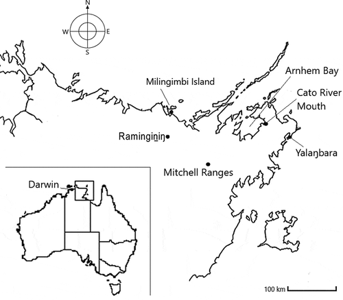
Everything, including the waters, has an owner and a manager. Gapu, with its many connections and many names, flows along ancestral pathways, forming and institutionalizing cultural practices and bestowing authority. We can take the example of a particular freshwater, provided for the Yolŋu in sites across Dhuwa territories by the ancestral beings, such as the Djaŋ’kawu sisters. Following the light of the Dhuwa morning star, the Djaŋ’kawu sisters paddled a canoe across the ocean and, at sunrise, landed on Yalaŋbara, far to the east of Milingimbi, on the east coast of the Gulf of Carpentaria (), where they pierced the sand with their digging sticks to create a freshwater hole – Milŋurr (Marika and West Citation2008), which belongs to the Rirratjiŋu clan group. As they travelled across the land, they left many named freshwater holes, and the peoples, places, and species that belong in each place created an ancestral network across the land and gapu.
2.2 Yolŋu philosophy of gapu
Today, many sub-groups of the Dhuwa Yolŋu still claim the Djaŋ’kawu as a primary totem, while many Yirritja Yolŋu claim Djaŋ’kawu as their mother. They are the djuŋgaya, the child in the yothu–yindi pair. The Dhuwa people, under the watchful eyes of their djuŋgaya caretakers, continue to perform large ceremonies re-enacting the two beautifully decorated sisters, paddling, dancing, swaying their hips, thrusting digging sticks into the sand, painting ceremonial objects, and singing.
Dhuwa philosophers (and their djuŋgaya) also continue to mobilize the object lessons of Djaŋ’kawu water in their discussions around knowledge production, child development, conflict resolution, and agreement making. For example, the freshwater bubbling-up in Milŋurr at Yalaŋbara, and the saltwater ebbing and flowing from the sea, talk of interaction and balance in the minds and lives of the Rirratjiŋu people, where two opposites (e.g. fresh and saltwater, or Dhuwa and Yirritja) mutually nurture and care for each other (Marika Citation1991). In another example, the Milŋurr philosophy inspires Yolŋu educational theorists to insist upon a “bala-ga-lili” (two-ways, or both-ways) curriculum practice at Yolŋu community and homeland schools. Under this theory, Yolŋu students learn the Australian National Curriculum alongside the equally respected Yolŋu ways of knowing, doing, and being. A balance is required for a fully rounded knowledge of the two types of educational philosophies.
Each Yolŋu child is equipped with the knowledges inherited through matrilineal and patrilineal ancestry – Yirritja and Dhuwa (Waṉambi et al. Citation2020). Contra to conventional western views that newly born babies are purely empty – tabula rasa – and ready to absorb whatever is surrounding them, Yolŋu babies are born with sacred names for their bones (Gurruwiwi Citation2008) and sacred gapu in their brains, ready for their growth into their ancestral languages, songlines, and sacred designs, as invested by the ancestral beings of their particular sacred places. Succinctly articulated as “ŋarrakala warraŋulthirrina dhäwunydja” (Dhurrkay Citation2014), literally meaning “the story has come outside of my body,” the manifestation of bodily invested knowledge is the internal journey of discovering who they are and how they are becoming, by virtue of being particular kin to a particular land.
Thus, let us briefly consider Yirritja gapu. Perhaps most famous is the Yirritja floodwaters, gurryalayala, which pour down from the Mitchell Ranges () at the height of the monsoon, singing and dancing, rushing from Yirritja place to Yirritja place through many watercourses, calling out the sacred names until it reaches the sea. When Yirritja cleansing ceremonies are held, the pathways of the waters are cried out by ceremonial leaders, and as the floodwater arrives at a particular place on the songline, the people of that totemic connection go down into the sea to be purified.
Different Yirritja groups have their own Yirritja waters in place, conferring particular rights and meanings. On their country, the Wangurri people are calm, as garmak gularri, a body of Yirritja floodwater flows to the sea from their freshwater homeland, Dhälinybuy. From the mouth of Wangurri country, along the Cato River into Arnhem Bay (), the main stream of garmak gularri confidently flows, speaks, thinks, and makes up its mind as to which direction it takes through the creeks and how it connects with other people along its path (Buthimaŋ Citation2010). While picking up twigs, leaves, and fragments of paperbark trees, the sound of rapids is heard when it meets with its sister’s water and becomes brackish. Yirritja, like Dhuwa, have special words for the sacred waters – for example, gayilinydjil: the water in Wangurri people’s heads. The particular words for the sacred constitution of a person’s mind are treated with great respect and are called up to serve in mediation if any conflict or tension arises between individuals or clan groups (Garŋgulkpuy Citation2002).
Garmak manbuyŋa is one of many Yirritja saltwater currents in Arnhem Bay () with which freshwater garmak gularri converges and diverges along its “cultural flow.” It is a grandchild of garmak gularri saltwater that overflows and makes a rushing roaring noise wherever it runs, to whichever group and watercourse it flows, and it all originated in the place called gurrumala (Guthadjaka et al. Citation2015). Like its grandmother, it collects leaf litter and dust on its surface and distributes them to the places and people along its flow path when it arrives, meets, and diverges. Both garmak manbuyŋa and gularri are the waters of Yirritja, carrying the deep knowledge of the Wangurri and Warramiri people. When the seawater of manbuyŋa and the over-flooding Yirritja freshwater come together, they die and produce a strong smell (Guthadjaka et al. Citation2015) – the sign of agreement among Yirritja groups.
Such Yirritja water life and philosophy is more than a metaphor; in ceremony it is called out with vibrating vocal codes, choreographed with ancestral footsteps, and animated by the sound of clapping sticks accompanied with the didgeridoo, keeping lands and peoples and waters alive. Learning the cultural flow is about the distribution of resources and knowledge, and the practice of diplomacy as the bodies of Yolŋu water. Such symbolic embodiment of calmness and diplomacy, for example, is painted with white clay on Wangurri people’s bodies for ceremonial work, as garmak gularri.
3 Study site
3.1 Milingimbi water resources – Yolŋu gapu
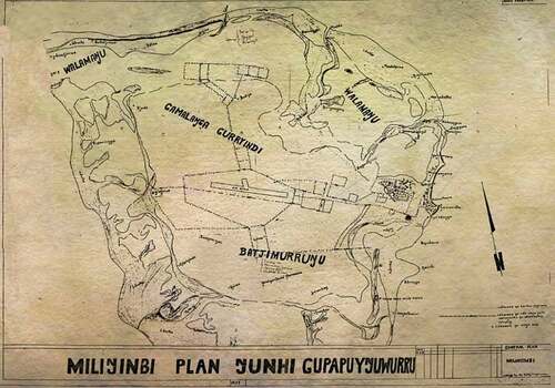
Although small in size, 70 km2 , Milingimbi, one of the Crocodile Islands in the Arafura Sea (), constitutes the estates of several Yirritja and Dhuwa groups: Walamaŋu and Batjimurruŋu (both Yirritja), Gorryindi and Gamaḻaŋga (both Dhuwa) (Djäwa Citation1979), and their djuŋgaya caretakers (). The island is named after one of the freshwater billabongs, located on the northwestern side of the island, and was created by an ancestral being. Milingimbi billabong, alternatively known as Yurrwi, emerged after being struck with lightning by the ancestral snake Wunhaŋu, when travelling from the mainland (Djäwa and Milaypuma Citation2019). Intrigued by the sound of lightning, an ancestral stingray, hiding itself in the mud under the bottom of Bodiya billabong, and also known as Buḻku (located on the northern side of the island), departed for Yurrwi (Bawayŋu et al. Citation2017). Chased by an ancestral shark swimming from the northern shore of the island, it hurried to reach Yurrwi, but was too late; the ancestral snake had disappeared. On departing the island, both the ancestral stingray and shark left their livers, which are now visible in the form of two exposed flat rocks at places known as Djäḻuwa and Djuliŋaṉaŋara.
Figure 2. Map of Milingimbi Island, 1976, by Wunyimarra, showing the ownership of clan estates in Gupapuyŋu language
Each water source on the island has its distinctive history and ancestral connections. Like the other Yolŋu Aboriginal gapu, Milingimbi gapu are brought from the ancestral past into the present with the collective (re)presentation of narratives, songlines, and ancestral choreography and design under the watchful eyes of the traditional landowners and their managers. In this context, traditional landowners exert ancestral authority over traditional knowledge invested by particular ancestral beings at particular places, yet in such a way that no one can speak for everyone or everything.
The matrilineal descendants of the traditional landowners, such as a women’s children, grandchildren (from the daughters’ side), or great-grandchildren, each provide their labour to the traditional landowners. Their mothers’, grandmothers’, and great-grandmothers’ ancestral knowledge is collaboratively looked after and its accountability is collectively enacted through management responsibility chains.
All the landowners of Milingimbi have other estates on other islands or the mainland. Historically, people visited the island seasonally, as the land called them for particular purposes – whether ceremonial or economic (Roy Citation2015). The existence of enormous shell middens alongside freshwater soaks provides evidence of the long history of hunting in the area. The Gamaḻaŋga landowners tell an ancestral story wherein the wallaby, a middle-sized marsupial mammal belonging to the kangaroo family, preserved small soaks of freshwater around pandanus palms after the bush cockroach, in a fit of rage, made the freshwater soaks salty by urinating in them. The bush cockroach did so in retaliation for a careless ceremonial painting effort – two red spots on the cockroach’s back – undertaken by the painted gecko, who had previously been beautifully decorated by the cockroach himself (Djanpa’lil Citation1978). The precious and often unreliable freshwater soaks on the tiny flat Yolŋu islands constantly remind Yolŋu of their responsibility to take their ceremonial obligations seriously.
In more recent history, the Macassan people from Sulawesi (now in Indonesia) sailed to the north coast of Australia during the annual monsoon to harvest sea cucumbers, which are highly valued in traditional Chinese medicine and as a delicacy. Along the long, shallow beach on the eastern side of Milingimbi Island, the Macassans and Milingimbi Yolŋu combined their efforts and resources to collect, dry, and smoke the sea cucumbers, together. The international sea traders established temporary residential bamboo huts (Rräyiŋ Citationn.d.) around Yurrwi, the permanent freshwater spring, also known as the Macassar Well. The ancestral spring was originally small and traditionally used to soak poisonous cycad nuts for leeching, before ceremonial consumption. The Macassans are said to have enlarged the well to increase water access and supply. Today, the Macassar Well is covered with the leaves and fruit of tamarind trees brought by the seafarers. The international trade between the Macassans and Milingimbi Yolŋu lasted for at least 200 years, until the Australian government forbade further arrivals in 1907. Yolŋu stories of their primarily peaceful and productive collaborations with Macassans are often provided as examples of how traditional Yolŋu and contemporary scientific governance and practice can respectfully work together.
3.2 Milingimbi water resources – western science hydrology
Shortly after the departure of the last Macassan, Milingimbi Island, “an emerald set in a sapphire sea” (Rev. James Watson cited in McMillan Citation2001, 89), became the first Methodist Overseas Mission in East Arnhem Land in 1923. As commonly seen in Methodist missions, agricultural activities played a large part in the daily activities on the island. This marked the beginning of the scientific study of water. In the early mission period, one community’s hand-dug well supplied all domestic use for many years, as well as supplying water for the irrigation of five acres of land, which was used to grow a range of vegetables and fruits. During World War II (1940–1943), the Royal Australian Air Force also used the well as a water supply point. Due to the increased demand for freshwater for farming practices and the island’s growing population, in 1958 the first groundwater production bore was drilled and equipped to supplement a network of mission wells (Augustine Citation1960), followed by further drilling in 1966. The increased capacity from these two bores – up to 500 m3 /day – meant that daily life on the island was manageable, with the supplement of brackish water during the dry season (Yin Foo Citation1980). However, due to the expanding and more permanent population on the island, and the potential risk of water scarcity, in 1971 the Northern Territory Government Water Division recommended that some of the residents on the island move to the mainland. What followed was the resettlement of people who had originally moved from Ŋangaḻaḻa to Milingimbi Island when the mission was established, and consequently led to the establishment of Ramingiṉiŋ community on the mainland (30 km inland from the coast and adjacent to Milingimbi Island; see ).
In 1982, in response to the ongoing uncertainty regarding the groundwater supply on the island, a hydrological investigation was undertaken to expand and increase the supply with the construction of four new production bores in the central region of the island. At the time, the island population was 750, and based on the findings of the hydrological investigation it was recommended that long-term monitoring of water quality also be established to assess the risk of saltwater intrusion into the aquifer (Yin Foo Citation1982). Thirty years later, two other hydrological investigations were conducted, which included a numerical model of the island’s aquifer system to evaluate the sustainable yield of the aquifer (URS Australia Citation2011) and a drilling programme of new production bores and monitoring wells (Woodgate Citation2014). Despite these efforts, there was still a large amount of uncertainty regarding the spatial extent and geometry of the fresh groundwater lens, the groundwater recharge processes as a result of the highly seasonal rainfall between the wet and the dry seasons, the amount of lateral flow towards the coast, and the risk of saltwater intrusion or saline water up-coning from the underlying aquifers (Noorduijn et al. Citation2019, Banks et al. Citation2021).
Ensuring the long-term sustainable management of the groundwater resource is of utmost importance to the remote, resource-constrained island of Milingimbi, which is threatened by sea-level rise and climate change. Small island groundwater resources are still insufficiently characterized (Alberti et al. Citation2017), and the limited hydrological knowledge plays a major role amongst numerous other compounding factors in developing sustainable water management policy and strategy (White and Falkland Citation2010). In such hydrological crises, physical scientists assess and, where possible, quantify the impacts of groundwater pumping on the availability and quality of the fresh groundwater lens in meeting the demands of the island communities. This involves bringing together a range of different spatial and temporal datasets to develop a hydrological conceptual model of the island aquifer system. These datasets include information on the climate, land use, vegetation type, soil type, geology, hydrogeology, and groundwater pumping, along with other observational data. The knowledge and understanding of the key physically based processes gained from building one or more conceptual models supports and guides physical scientists (hydrologists) to be able to develop and construct numerical groundwater flow and solute transport models to explore different scenarios (e.g. climate change, variable recharge conditions, or different groundwater pumping schedules) and to make informed decisions on the management of the water resources based on the possible outcomes.
4 Negotiations towards the management of Milingimbi water
Contemporary environmental guidelines, including groundwater management strategies, regularly draw upon knowledge generated by scientific inquiry (e.g. Bryant and Wilson Citation1998), emphasizing a so-called evidence-based approach (Head Citation2010). This way of knowing is derived from evidence collected, analysed, and validated by “experts” through processes that meet the canons of science, which in most instances is Western science, per the precepts of the Enlightenment (e.g. Popper Citation1963). Knowledge sustains power that, in turn, defines governance and management strategies (Foucault Citation1982). In policy and practice, the hegemony of scientific knowledge has contributed centralized, standardized, and technical solutions to a wide and diverse range of issues, including water management, rolled out across the world (Long Citation1992, Bryant and Wilson Citation1998).
Notwithstanding such historical and contemporary political, economic, and environmental pressures in water management and governance (Bakker and Cook Citation2011, McGregor Citation2014, Obeng-Odoom Citation2016), Aboriginal people as traditional ecological knowledge experts seek dialogue and relationship-building activities with Western water experts to enhance productive collaboration for sustainable water management in Aboriginal communities facing contemporary environmental conditions (Jackson et al. Citation2019). In this study, we favoured a nuanced approach to develop and use knowledge to inform groundwater management. Our approach suggests that different knowledge governance traditions with distinctive philosophies, methodologies, and evaluations can work together even if they cannot be measured or evaluated by the same standards. Such differences are essential for understanding “real world problems” (Rangecroft et al. Citation2020).
4.1 A brief history of collaboration
Due to a lack of insufficient surface water, the inhabitants of Milingimbi Island depend on a reliable and sufficient water supply from the shallow (less than 40 m thick) fresh groundwater lens beneath the island. From 1980 to 2020, the population on the island doubled in size to 1225 residents (94.4% Yolŋu)Footnote1 and is expected to increase to 2000 residents by 2040. The community now faces considerable water supply concerns, as well as delays in the development of vital infrastructures such as housing, health service accommodation, and public toilets (Gibson Citation2019). There is therefore an urgent need for both physical and social science hydrological field and modelling investigations, and for the transdisciplinary engagement between Yolŋu rightsholders and service providers to engage in collaborative discussions considering the development of a community-led adaptive water management practice. The development of management strategies in the Milingimbi community requires multistakeholder engagement with Yolŋu rightsholders to ensure that the local Yolŋu cultural protocols of water and governance traditions be included and inform water management policies, as well as involve the community in the decision-making processes.
The Power and Water Corporation (PWC) is solely responsible for water delivery to 72 remote communities in the Northern Territory (NT), including Milingimbi Island. In 2009, PWC approached the Yolŋu Aboriginal Consultancy InitiativeFootnote2 at Charles Darwin University (CDU) to undertake a collaborative project to develop “good” ways for Milingimbi people to become involved in water management in their community and explore ways to inform its community water planning initiatives (Christie Citation2010). This Milingimbi Water project, titled Djäka gapuw ŋamathaŋ (Care properly for our water) presented the understanding of both Yolŋu ancestral-contemporary water and Milingimbi hydrology, including the quality and quantity of community water supply by storytelling in the form of narratives, dialogues, recorded interviews, and posters.Footnote3
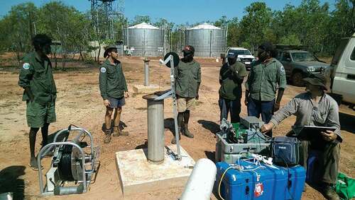
Growing interest amongst physical scientists and PWC about the local water governance and distinct ancestral water knowledge of those living on the island led to a Society of Exploration Geophysics Geoscientists Without Borders project collaboration in 2014. Hydrogeologists from Flinders University (FU), the Commonwealth Scientific and Industrial Research Organisation (CSIRO), PWC, and the local Crocodile Islands Rangers – based on Milingimbi Island – worked together to support the Milingimbi Island water supply investigations. As part of the project, local community members were engaged in training and the use of geophysical instruments to improve the knowledge and understanding of the island’s groundwater resources (). Subsequently, between 2016 and 2019 there followed the long-term “Cross-cultural management of water on resource-constrained islands” research project, funded by the Australian Research Council (ARC), on devising strategies for local engagement in water management. The next section details how this project was initiated and the community engagement strategies that were undertaken with the traditional owners of Milingimbi Island and Yolŋu elders.
Figure 3. Engaging with local community members in training and use of geophysical instruments. Photos used with permission of Eddie W. Banks; copyright 2014 Crocodile Island Rangers
4.2 Welcome to country and community engagement
As part of the initial phase of the three-year research project, the project members participated in a field excursion around the island led by the traditional owners of Milingimbi Island and Yolŋu elders and their caretakers. On the bank of Nilatjirriwa, a large circular billabong, Yolŋu elders welcomed us – the physical and social scientists – to the water and shared its creation story, so that we were recognized and looked after by the land and water while on the island. At this location, the scientists asked the Yolŋu elders about the water quality history of the billabong and requested to use a water quality instrument to assess the salinity of the water. The scientists communicated that the salinity measurement from the billabong together with other climate, geology, and hydrology data would assist them to develop a hydrogeological conceptual model of the island.
During the tour, the physical scientists were interested in installing field equipment to monitor evapotranspiration and soil moisture conditions within a stand of paperbark trees where groundwater discharge was occurring between the elevated area of the island and tidal mudflats. While identifying a suitable site location within the stand of paperbark trees, Yolŋu elders were keen to teach how particular paperbark trees could provide a water source in times of need. They shared a story of how their ancestors used to walk for long distances during hunting and accessed the paperbark trees to quench their thirst. At another site, the scientists earnestly demonstrated for the Yolŋu elders how Western science describes the process of evapotranspiration and the movement of water from the soil zone to the atmosphere via the vegetation. This was demonstrated by sealing a small green tree branch into an airtight plastic bag. After a short time, drops of water appeared inside the bag; this demonstration was akin to the scientific authority and witnesses of Boyle’s air pump (see Shapin and Schaffer Citation1985). At particular places on the island, different waters were visited and presented by Yolŋu elders and hydrologists as matters of care.
4.3 Participatory three-dimensional mapping
Both Western science’s view of water and the water cycle and the Yolŋu gapu need to be cared for, rather than forced to fit within the same cast, regardless of epistemic incompatibilities. The approach we proposed recognizes and respects such incommensurabilities and worked towards a “creative assemblage,” in Deleuze and Guattari’s (Citation1980) terms, with the particular goal of enhancing groundwater management in Milingimbi, while taking seriously human and other-than-human actors, and resisting hybridization of knowledges. Unique plans, bearing traces of previous knowledge production episodes, emerge from the ground up in this Yolŋu governance practice. How could heterogeneous knowledge communities work together at a particular place with a particular people? What could a creative assemblage of different water experts look like, and what could make its governance sustainable?
We explored the potential of P3DM to create the space for dialogue between these two heterogeneous knowledge practices. Emerging in the late 1990s, P3DM attempts to offer a middle ground between different approaches in the hope of facilitating a dialogue between Aboriginal people and scientists/government officials (Rambaldi et al. Citation2000). The dialogue is stimulated through a process in which local people build large-scale relief models and 3D maps of their surroundings using local materials (e.g. carton, paper, cork). The participants then create thematic layers of spatial information, such as land cover and anthropogenic features, over scaled maps that depict the local terrain. Points and areas on the maps are depicted by pushpins (or local equivalents), lines using yarns, and polygons created with paints and yarns.
Physical maps offer powerful opportunities to share spatial knowledge (Wood Citation1992). Such spatial knowledge is mediated and reflects different perceptions of the physical and social environment such that maps always mirror the mapper’s view of the world rather than absolute and unique truth. Therefore, there has long been a divide between “scientific” or “official/government” maps of a particular area and how local people, especially Aboriginal people, represent the same area (Cadag and Gaillard Citation2012).
During this P3DM activity, the scientists and government officials were invited to share their own knowledge at different stages of the mapping process, depending on the scope and purpose of the initiative. Thus, P3DM provided one of the key engagement resources to establish dialogue between the local communities and other stakeholders. The engagement of the Crocodile Island Ranger Group and traditional landowners in field data activities and the monitoring of hydrological observations was also crucial to the project due to the remote location of Milingimbi Island, in that frequent monitoring had to be conducted to ensure that the equipment was operating correctly.
In addition to providing opportunities to create a space for dialogue between different knowledge communities, the physically scaled, 3D map crafted during the community engagement strategy of the research project played its role as a boundary object. As an (in)tangible object (e.g. map or archive), or infrastructure (e.g. museum or library), a boundary object is sufficiently robust as to be able to hold knowledge practitioners from discrete knowledge communities together and let meaningful messages come through the communities (see Star and Griesemer Citation1989, Star Citation2010). It also needs to be flexible in its adaptation to the ongoing fluidity and negotiation between different knowledge practitioners, without either cancelling the other. It is a space where different knowledge practitioners trust each other, and live and work productively with respect and seriousness, without resolving epistemic differences.
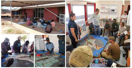
The mapping process, carefully negotiated with local rightsholders, followed a sequence, starting with the initial building of a physically scaled 3D model, followed by the plotting of land cover and generic anthropogenic features as well as cultural landmarks (). Mapping of the water-related features happened last, through a workshop session that gathered the local Yolŋu leaders and the research scientists. The former plotted locations where they sourced water as well as water-related cultural features such as soaks and billabongs. The scientists added information regarding the geology of the island and the location and depth of the groundwater lens. Aboriginal knowledge inclusion was involved from the early stages of the development of the conceptual model to capture important observations on the island that were not recorded by PWC or the government departments. For example, the location of permanent soaks/spring discharge and the areas of tidal inundation were important when considering the recharge processes and groundwater movement. They were also important in reminding the new generation of Yolŋu and the visiting scientists and bureaucrats about the complex patterns of traditional ownership and management of Milingimbi waters. Milingimbi gapu is multiple, not singular. Protecting and conserving it depends upon knowledge of its multiple histories and the resulting networks of ownership and management.
Figure 4. Participatory three-dimensional mapping (re)presenting both Milingimbi gapu and Western science hydrology. Photographer: Yasunori Hayashi
However, this process proved complicated, for many reasons. Firstly, maps are a numerically scaled and georeferenced representation of the Earth’s surface in either two or three dimensions. While this standardized representation of the world is appropriate for Western science, it is a very alien and foreign concept to Yolŋu gapu experts. Yolŋu, on the other hand, often avow quite different appreciations of space and distance, which may refer to landmarks and time, amongst other references. The Yolŋu knowledge authorities sporadically engaged with the map, while telling stories, and plotting some gapu features on the map. However, their knowledge of gapu always extended beyond the physical boundary of the map. Akin to other Yolŋu gapu, as introduced in Section 3, according to the elders, Milingimbi gapu flows into the ocean and travels along channels between the surrounding islands of Räpuma, Nilpaywa, and Murruŋga, to converge with other Dhuwa and Yirritja currents (Bawayŋu et al. Citation2017). As such, Milingimbi gapu was severely constrained by the limits of the 3D map – length, area, and number – by which Western science so confidently assumes that “objective” sections of land are created (Watson and Chambers Citation1989). The extent of the map obscured the full connections, and networks of Yolŋu ownership and authority are obscured.
Secondly, the physical map is metaphysically detached from the reality through which Yolŋu know and sense the landscape of Milingimbi. Unlike the island (re)presented on the map as a factual object, Yolŋu Aboriginal landscape is “recreating” (Christie Citation1984), “continued to be enacted” (Verran Citation1998), “redoing” (Law Citation2015) and “co-becoming” (Burarrwanga et al. Citation2019) with people. These concepts may be quite foreign to Western hydrologists, but are familiar concepts to Yolŋu. Working from the ground up, listening to peoples and their places, each group learned slowly from the other. The scientists learnt that the Yolŋu landscape was once made knowable when ancestral beings walked, danced, and cried; Milingimbi traditional owners and caretakers, carried and begotten by ancestral beings, bring the ancestral past into the present. Then, on another occasion they carry it into another present; that is how Yolŋu Aboriginal have immemorially continued to re-create, re-enact and re-do ancestral then-and-there into here-and-now, so they become a “relation” with every spatiotemporal event – billabongs, creeks, trees, rocks, and waves reaching the beach.
Negating the ontological split between nature and people – hyper-separation, per Deborah Bird Rose’s (Citation2004) terminology – Milingimbi elders found it hard to engage with the objective piece of land (re)presented on the map, which separated them from the reality of their Milingimbi landscape. Such ongoing world-making is situational; thus, the rationale and the relevance of the map were questionable in the Yolŋu Milingimbi world to the extent that fostering local people’s participation in the map building process was challenging. It was observed that only the local rangers of the Crocodile Island Ranger Group saw value in the P3DM process and actively contributed to mapping their island, because the group relied on maps and charts as part of their work in an operational institution structured along Western science principles.
As a process, the P3DM extended beyond the building of a 3D model of the island. It requires long-term engagement, updating and application to policy and practice, such as the case of this project in enhancing Milingimbi groundwater management. Due to the size of the map – too large to be stored at the rangers’ station – it was kept in a storeroom at a local cultural centre and intermittently updated when researchers visited the island, then eventually transferred to the local primary school where researchers and rangers hoped that teachers and students would not only look after it but also use it for teaching and learning about the island. This happened to some extent, but the lack of engagement of the teachers and students at the project planning stage proved an obstacle to their taking ownership over the map and to its potential integration in the school’s curriculum. More importantly, Yolŋu schoolchildren bodily inherit the knowledge of Milingimbi landscape through the trajectories of matrilineal and patrilineal ancestry (see Section 2), and learn the ways in which they continue to interact with Milingimbi Island. The interpretation of space that P3DM fosters is very western; it was indeed a good place to start, but we should always be open to the ways in which Yolŋu knowledge and Yolŋu gapu is part of an expansive network. Under Yolŋu authority, we often have some ideas as to where to start, but can never be sure where we will end up.
5 Situational care for transdisciplinary water management
5.1 Knowledge making and sharing
The combined potential for diverse ways of knowledge making to inform environmental management, including groundwater management, underpins a current academic momentum encouraging the integration of different types of knowledges so that the “best of both worlds” can be tapped (e.g. Failing et al. Citation2007, Reed Citation2008, Raymond et al. Citation2010). It is assumed that knowledge integration facilitates a dialogue between local people from the community, who use the water resources, and experts (often coming from outside of the community), who are institutionally empowered to manage the same resources. Proponents of this approach suggest that knowledges should ultimately be “hybridised” (Reed Citation2008), and result in common “outputs” (Raymond et al. Citation2010). This “integration imperative” is meant to provide opportunities for building trust between stakeholders on common matters so that there is mutual and collective “buy-in” towards management strategies. However, knowledge integration is more frequently an initiative forced upon a particular management issue, including water management, by experts who hold scientific knowledge rather than a ground-up approach, such as is initiated by local people who hold other ways of practising knowledge. In fact, the divide between scientific and other approaches to develop and govern knowledge may not be as sharp as depicted by many advocates of the “integration imperative,” and the pristine nature of the latter may, in many instances, be a myth (Agrawal Citation1995), a fringe (Ruggles Citation2010), or a dreaming in the Australian Aboriginal context.
Each form and enactment of knowledge reflects different epistemic practices and different metaphysical commitments that are often not up for negotiation, and thus irreconcilable, so that knowledge sharing is often seen as a battlefield (Long Citation1992). Such complex negotiations are part of the everyday life of Yolŋu (and other) Aboriginal people, but can be confronting and challenging to those from an academic positivist tradition (in hydrology as well as other physical and social sciences). For the scientist, such work entails (consciously or unconsciously) addressing ontological questions (e.g. “When Yolŋu talk about ‘gapu’, and we talk about ‘water’, to what extent are we talking about the same thing or quite different things?”) as well as the possible engagement with somewhat philosophical or procedural concepts, such as boundary objects. And then, downstream, these complex negotiations find themselves reproduced in government policies and programmes: practices of water resource management under the control of government and nongovernment agencies in the wider community need to be reconfigured to engage the ancestral and ongoing landscapes of Aboriginal governance. Failure to do so or inadequate community engagement and discussion and recognition of Aboriginal gapu knowledge will undermine efforts by PWC to undertake current and future water management programmes, and in worse cases will generate distrust amongst the end users.
Working towards a creative assemblage foregrounded by the care of both waters is imperative. Herein, care is not manifested as a provision of services for, or an emotional state concerning, someone or something which is in trouble; rather, care involves exploring what practices strengthen or erode sustainable ways of living and working together (Atkinson-Graham et al. Citation2015). The work of designing and implementing a water management strategy on Milingimbi Island requires weaving together hydrological insights and imperatives with Yolŋu networks of authority and accountability. Demonstrations of the knowledge of paperbark trees, for example, do not contribute directly to the hydrological aspects of the groundwater management plan, but contribute a great deal to the ways in which the plan will be integrated into the networks of authority and care – always connected to particular places and practices – which pervade the social and political lives of Milingimbi people.
5.2 Absence of centrality
Such a notion and practice of care is familiar to Yolŋu traditional knowledge governance foregrounded by the kinship practice. In considering care with the Yolŋu Aboriginal landscape, neither the decentralization of society from an anthropocentric world nor centralization of other-than-humans into a world-making is sufficiently careful. Yolŋu kinship is a “hollow-centre” (Hayashi Citation2020), where everyone and everything is an active constituent of the Yolŋu world, with an absence of centrality. The relationship between the ancestral snake and ancestral stingray at Yurrwi and at Bodiya water is yothu–yindi, literally the child and its mother. As a caretaker for their yindi, the yothu devote themselves to strengthen, supervise, and sustain their mother’s knowledge practice, and so on. The billabong, Nilatjirriwa, which came into existence on the west side of the island when a boomerang thrown by an ancestral figure hit the ground, is a mother (yindi) of Yurrwi and grandmother (mother’s mother) of Bodiya. As such, the continual networking of yothu–yindi landscape, including ancestral beings, water resources, and human ancestors/descendants, were/are caring and living together then/now on Milingimbi Island. Such ongoing life-becoming is a “transformative ethos of care” (Puig de la Bellacasa Citation2011) for human and other-than-human worlding. At every corner of Milingimbi Island, care was witnessed by Yolŋu gapu and physical and social science water experts.
Learning from the hollow-centre becoming of Yolŋu kinship practice, every human and every other-than-human could be interpreted as a boundary object in Yolŋu world-making. Akin to the P3DM as a boundary object holding onto the different epistemic practices, everyone and everything constituting the Milingimbi landscape continues within different knowledge communities, namely Yirritja and Dhuwa, and Yothu and Yindi; otherwise, they are divided. From this account, a possible transdisciplinary water strategy on the island is to (re)articulate a difference differently. This is indicated by the growing concern of freshwater scarcity demonstrated by the hydrogeological investigation, which showed the critical balance between the recharge rate of the freshwater aquifer and discharge rate into the surrounding sea. The relationships of caring between Yolŋu water experts and the water supply company, PWC, had been a major community concern over an extended period of time (Spencer et al. Citation2019).
Stepping back from the application of established hydrogeological or social theories, but attending to a fact or concern with the intention of engagement with a particular real world problem, ensures that the fact/concern is constantly (re)negotiated at particular places by particular people at a particular time, then (re)emerges as a situational care. In so doing, the “thinking-with” paradigm is crucial, and the “thinking-about” by individuals is strongly resisted (Puig de la Bellacasa Citation2012). This was achieved by both the Yolŋu gapu and the physical and social science water experts who participated in this ARC linkage project. The relationalities between those different water experts were not deemed to be stable or fixed in their incommensurable nature, yet were sufficiently durable as to resist integration while continuing to work together.
In collaborative resource management plans negotiated with Yolŋu, it is essential to know the Dhuwa–Yirritja divide because that is the divide across which all that is “owned” is “managed” – an ancestral regime of mutual accountability which must always be respected and exercised. In titling this paper using the term “transdisciplinary,” our intention was not to produce a completely new idea or concept, but rather to earnestly propose a new way of engaging with different knowledge practitioners – Yolŋu Aboriginal gapu and Western hydrology. Without the transdisciplinarity which characterized this research work, Yolŋu practices could not be engaged; as a result, in a government-sponsored water resource management plan or practice, they can be undervalued, or in the worst case ignorantly ignored. On the banks of Nilatjirriwa, Yolŋu traditional owners and custodians welcomed us to their country and explained the ancestral ownership and connection of the billabong, alongside physical scientists who read the numerical figures displayed on the water quality instrument. Neither knowledge practice would dominate or cancel the other. Attending to particular places and people without forming an agreement demonstrates that it is still possible to engage with gapu and hydrology while working together in a decolonizing way in Milingimbi.
6 Conclusion
This paper has introduced one of many ways in which water can be differently known and conserved in Aboriginal northern Australia, and has signalled a need for sensitive care when and where Aboriginal traditional owners of gapu and physical scientists (hydrologists) work together on Aboriginal lands. The predicative expression, “working together,” is not straightforward in any sense, as can be noticed in the voice of the different sections expressing gapu and hydrological accounts in this paper. As we have seen, even among the Yolŋu owners and caretakers of the small island of Milingimbi, there are diverse languages, commitments, responsibilities, and histories to be kept alive and separate. Yolŋu knowledge practices were themselves always already transdisciplinary. “Working together” requires careful ontological and epistemological work; otherwise, it could create difficulties for any (or all) knowledge practitioner(s). This is not merely an ethical issue. The viability of a water supply is at stake, which in the long term entails ongoing local governance and collaborative water management using approaches that are consistent both with hydrological insights and with local networks of knowledge and authority.
“Working together” will be a vulnerable journey to find a situational agreement ongoingly, rather than a stable meeting point or a stabilized and binding management plan stretching into the future. The theoretical assumption that the binaries could be firmly interlocked and productively yield an interdisciplinary collaborative knowledge actually undermines and marginalizes – and, in the worst cases, ignorantly ignores – Aboriginal knowledges. Therefore, there is an acute need in northern Australia and across Aboriginal Australia to slow down and ponder the potential meaning of “working together” and how it could be alternatively discussed and performed, and to consider how Western hydrological science can benefit from the Aboriginal traditional owners of the land and water through research strategies that encompass and recognize transdisciplinarity. In our study, we engaged with their ancestral ways of doing and being, such that we were able to establish an open dialogue that was accepted on Aboriginal country to discuss government water policies and programmes as well as cutting-edge hydrological science and knowledge. A clearer understanding of the complex entailments of transdisciplinarity – particularly its always local, always provisional nature – is essential for hydrologists collaboratively designing management systems in cross-cultural contexts.
Acknowledgements
This work was supported by the Australian Research Council Linkage Project LP150100588. Special thanks to the traditional owners and caretakers of Walamaŋu, Batjimurruŋu, Gorryindi, Gamaḻaŋga land and water, and the Crocodile Island Rangers, Milingimbi Island, NT, for providing their assistance in the field and sharing gapu knowledge. Thanks, also, to Jeremy Garnett of Top End Editing for help with the proofreading and formatting of this paper.
Disclosure statement
No potential conflict of interest was reported by the authors.
Additional information
Funding
Notes
1 2016 Australia National Census – Australian Bureau of Statistics http://www.abs.gov.au/census
2 See the project website, https://www.cdu.edu.au/centres/yaci/index.html
3 See the project website, https://www.cdu.edu.au/centres/yaci/projects_milingimbiwater.html
References
- Agrawal, A., 1995. Dismantling the divide between indigenous and scientific knowledge. Development and Change, 26 (3), 413–439. doi:https://doi.org/10.1111/j.1467-7660.1995.tb00560.x.
- Alberti, L., La Licata, I., and Cantone, M., 2017. Saltwater intrusion and freshwater storage in sand sediments along the coastline: hydrogeological investigations and groundwater modeling of Nauru Island. Water, 9 (10), 788. doi:https://doi.org/10.3390/w9100788.
- Atkinson-Graham, M., et al., 2015. Care in context: becoming an STS researcher. Social Studies of Science, 45 (5), 738–748. doi:https://doi.org/10.1177/0306312715600277.
- Augustine, P., 1960. Milingimbi mission water resources survey field officers report. Technical Report WRD60012. Northern Territory Water Resources Branch.
- Bakker, K. and Cook, C., 2011. Water governance in Canada: innovation and fragmentation. International Journal of Water Resources Development, 27 (2), 275–289. doi:https://doi.org/10.1080/07900627.2011.564969.
- Banks, E., et al., 2021. Fresh groundwater lens dynamics of a small bedrock island in the tropics, Northern Australia. Journal of Hydrology, 595, 125942. doi:https://doi.org/10.1016/j.jhydrol.2020.125942
- Bawayŋu, L., et al. 2017. Gapu Napurruŋ [video]. Northern Institute, Charles Darwin University. Available from: http://groundup.cdu.edu.au/index.php/cross-cultural-management-of-freshwater-on-resource-constrained-islands-arc-linkage/ [ Accessed 3 July 2020].
- Bryant, R.L. and Wilson, G.A., 1998. Rethinking environmental management. Progress in Human Geography, 22 (3), 321–343. doi:https://doi.org/10.1191/030913298672031592.
- Burarrwanga, L., et al., 2019. Songspirals. Sydnery: Allen and Unwin.
- Buthimaŋ, T., 2010. Garmak Gularriwuy. Learning Communities: International Journal of Learning in Social Contexts, (2), 38–47.
- Cadag, J.R.D. and Gaillard, J.C., 2012. Integrating knowledge and actions in disaster risk reduction: the contribution of participatory mapping. Area, 44 (1), 100–109. doi:https://doi.org/10.1111/j.1475-4762.2011.01065.x.
- Christie, M., 1984. The Aboriginal world view: a white person’s ideas. In: M. Christie, S. Harris, and D. McClay, eds. Teaching Aboriginal children: milingimbi and beyond. Mt Lawley: Institute of Applied Studies, 3–7.
- Christie, M., 1994. Grounded and ex-centric knowledges: exploring Aboriginal alternatives to western thinking. In: J. Edwards, ed. Thinking: international interdisciplinary perspectives. Melbourne: Hawker Brownlow Education, 24–34.
- Christie, M., 2006. Transdisciplinary research and Aboriginal knowledge. The Australian Journal of Indigenous Education, 35, 78–89. doi:https://doi.org/10.1017/S1326011100004191
- Christie, M., 2010. Milingimbi Water. A Report to the Power and Water Corporation from the Yolŋu Consultancy Initiative. Darwin: Uniprint.
- Christie, M., 2013. Generative and ‘ground-up’ research in Aboriginal Australia. Learning Communities: International Journal of Learning in Social Contexts, 13, 3–13.
- Deleuze, G. and Guattari, F., 1980. Capitalisme et Schizophrénie: mille Plateaux. Paris: Les Editions de Minuit.
- Dhurrkay, G. 2014. Wanhaŋur yäku ŋali ŋuli märram? Available from Indigenous Consultant and Researcher Database: https://espace.cdu.edu.au/collection/cdu:63084 [ Accessed 23 April 2020].
- Djanpa’lil. 1978. Boḏuk. Milingimbi: Milingimbi Literature Production Centre. Available from Living Archive of Aboriginal Languages: http://laal.cdu.edu.au/record/cdu:39325/info/ [ Accessed 3 October 2020].
- Djäwa. 1979. Miliŋinbi: dhuwala Yolku Wäŋa. Milingimbi: Milingimbi Literature Production Centre. Available from Living Archive of Aboriginal Languages: http://laal.cdu.edu.au/record/cdu:33735/info/ [ Accessed 24 April 2020].
- Djäwa, T. and Milaypuma, G. 2019. Miliŋinbi Gapu Maŋutji (Macassar Well) [video]. Available from Indigenous Consultant and Researcher Database: https://espace.cdu.edu.au/view/cdu:62438 [ Accessed 23 October 2020].
- Failing, L., Gregory, R., and Harstone, M., 2007. Integrating science and local knowledge in environmental risk management: a decision-focused approach. Ecological Economics, 64 (1), 47–60. doi:https://doi.org/10.1016/j.ecolecon.2007.03.010.
- Falkland, A. and Custodio, E., 1991. Hydrology and water resources of small islands: a practical guide. Paris: UNESCO.
- Ferguson, G. and Gleeson, T., 2012. Vulnerability of coastal aquifers to groundwater use and climate change. Nature Climate Change, 2 (5), 342–345. doi:https://doi.org/10.1038/nclimate1413.
- Foucault, M., 1982. The subject and power. Critical Inquiry, 8 (4), 777–795.
- Garŋgulkpuy, J., 2002. Yolŋu Baḻandi-waṯaŋumirr: yolŋu with ancestral connections. Galiwin’ku: NT Yalu Marŋgithinyaraw Research Group.
- Gibson, J. 2019. Milingimbi water concerns stall future developments in Arnhem Land, ABC News, Available from: https://www.abc.net.au/news/2019-11-10/milingimbi-water-shortage-concerns-in-arnhem-land/11686470 [ Accessed 10 November 2019].
- Gurruwiwi, J., 2008. Bundurrpuy. What does Bundurr mean? Learning Communities: International Journal of Learning in Social Contexts, 2, 48–49.
- Guthadjaka, K., Christie, M., and Verran, H., 2015. Manbuynga Garmak Warramirri: the meaning of the deep sea water belonging to the Warramiri people. Darwin: Northern Institute, Charles Darwin University.
- Hayashi, Y., 2020. Everyone and everything is a boundary object – an empirical account from a modest human boundary object. Learning Communities: International Journal of Learning in Social Contexts [Special Issue: Collaborative knowledge work in northern Australia], 26 (26), 58–63. doi:https://doi.org/10.18793/lcj2020.26.09.
- Head, B.W., 2010. Water policy—Evidence, learning and the governance of uncertainty. Policy and Society, 29 (2), 171–180. doi:https://doi.org/10.1016/j.polsoc.2010.03.007.
- International Groundwater Resources Assessment Centre, 2018. Groundwater overview: making the invisible visible. UN WATER. Available from: https://www.unwater.org/publications/groundwater-overview-making-the-invisible-visible/ [ Accessed 1 October 2019]
- Jackson, M., Stewart, R.A., and Beal, C.D., 2019. Identifying and overcoming barriers to collaborative sustainable water governance in remote Australian indigenous communities. Water, 11 (11), 2410. doi:https://doi.org/10.3390/w11112410.
- Law, J., 2015. What’s wrong with a one-world world? Distinktion: Scandinavian Journal of Social Theory, 16 (1), 126–139. doi:https://doi.org/10.1080/1600910X.2015.1020066.
- Long, N., 1992. From paradigm lost to paradigm regained? The case for an actor-oriented sociology of development. In: B. Long and A. Long, eds. Battlefields of knowledge: the interlocking of theory and practice in social research and development. London: Routledge, 3–24.
- Marika, B. and West, M.K.C., 2008. Yalangbara: art of the Djang’kawu. Darwin: Charles Darwin University Press.
- Marika, R., 1991. Milŋurr. Yän, 2, 22–23.
- McGregor, D., 2014. Traditional knowledge and water governance: the ethic of responsibility. AlterNative: An International Journal of Indigenous Peoples, 10 (5), 493–507. doi:https://doi.org/10.1177/117718011401000505.
- McMillan, A., 2001. An intruder’s guide to East Arnhem land. Sydney: Duffy & Snellgrove.
- Noorduijn, S., et al., 2019. Quantitative evaluation of the freshwater resources on Milingimbi Island- groundwater modelling report. Adelaide: National Centre for Groundwater Research and Training, Flinders University.
- Obeng-Odoom, F., 2016. Marketising the commons in Africa: the case of Ghana. Review of Social Economy, 74 (4), 390–419. doi:https://doi.org/10.1080/00346764.2016.1186819.
- Popper, K.R., 1963. Conjectures and refutations. The growth of scientific knowledge. London: Routledge.
- Puig de la Bellacasa, M., 2011. Matters of care in technoscience: assembling neglected things. Social Studies of Science, 41 (1), 85–106. doi:https://doi.org/10.1177/0306312710380301.
- Puig de la Bellacasa, M., 2012. ‘Nothing comes without its world’: thinking with care. The Sociological Review, 60 (2), 197–216. doi:https://doi.org/10.1111/j.1467-954X.2012.02070.x.
- Rambaldi, G., Mendoza, M., and Ramirez, F., 2000. Adding the fourth dimension to participatory 3-D modelling. PLA Notes, 39, 19–24.
- Rangecroft, S., et al., 2020. Guiding principles for hydrologists conducting interdisciplinary research and fieldwork with participants. Hydrological Sciences Journal, 66, 1–12.
- Raymond, C.M., et al., 2010. Integrating local and scientific knowledge for environmental management. Journal of Environmental Management, 91 (8), 1766–1777. doi:https://doi.org/10.1016/j.jenvman.2010.03.023.
- Reed, M.S., 2008. Stakeholder participation for environmental management: a literature review. Biological Conservation, 141 (10), 2417–2431. doi:https://doi.org/10.1016/j.biocon.2008.07.014.
- Rose, D.B., 2004. Reports from a wild country: ethics for decolonisation. Sydney: UNSW Press.
- Roy, L. 2015. Lily Roy traditional owner at Milingimbi - Lily differentiating Yolŋu governance from Yolŋu leadership [video]. Available from Indigenous Governance and Leadership Development: https://igld.cdu.edu.au/lily-roy-traditional-owner-at-milingimbi-2/ [ Accessed 14 November 2020].
- Rräyiŋ. n.d. Maŋgatharra ga waŋarr wuŋgan. Milingimbi: Milingimbi Literature Production Centre. Available from Living Archive of Aboriginal Languages: http://laal.cdu.edu.au/record/cdu:45945/info/ [ Accessed 3 October 2020].
- Ruggles, C., 2010. Indigenous astronomies and progress in modern astronomy. Preceedings of Science, 1–8.
- Shapin, S. and Schaffer, S., 1985. Leviathan and the air-pump. Princeton, NJ: Princeton University Press.
- Spencer, M., Dányi, E., and Hayashi, Y., 2019. Asymmetries and climate futures: working with waters in an indigenous Australian settlement. Science, Technology & Human Values, 44 (5), 786–813. doi:https://doi.org/10.1177/0162243919852667.
- Star, S.L., 2010. This is not a boundary object: reflections on the origin of a concept. Science, Technology & Human Values, 35 (5), 601–617. doi:https://doi.org/10.1177/0162243910377624.
- Star, S.L. and Griesemer, J.R., 1989. Institutional ecology, `translations’ and boundary objects: amateurs and professionals in Berkeley’s museum of vertebrate zoology, 1907–39. Social Studies of Science, 19 (3), 387–420. doi:https://doi.org/10.1177/030631289019003001.
- United Nations, 2016. United Nations sustainable development goals. Available from: https://www.undp.org/content/dam/undp/library/corporate/brochure/SDGs_Booklet_Web_En.pdf [ Accessed 2 May 2020].
- URS Australia, 2011. Final report - regional groundwater consultancy - Milingimbi stage 1. Darwin, NT: Power and Water Corporation.
- Verran, H., 1998. Re-imagining land ownership in Australia. Postcolonial Studies: Culture, Politics, Economy, 1 (2), 237–254. doi:https://doi.org/10.1080/13688799890165.
- Waṉambi, G., Bulkanhawuy, J., and Hayashi, Y., 2020. Kinship as multiple languages inheritance. Australian Linguistic Society Conference 2020: Building bridges, 14–15 December. Online Conference. Available from: https://als.asn.au/Conference/Conference2020.
- Watson, H. and Chambers, D.W., 1989. Singing the land, signing the land: a portfolio of exhibits. Geelong: Deakin University.
- Werner, A.D., et al., 2013. Seawater intrusion processes, investigation and management: recent advances and future challenges. Advances in Water Resources, 51, 3–26.
- White, I. and Falkland, T., 2010. Management of freshwater lenses on small Pacific islands. Hydrogeology Journal, 18 (1), 227–246. doi:https://doi.org/10.1007/s10040-009-0525-0.
- Wood, D., 1992. The power of maps. New York: Guilford Press.
- Woodgate, M., 2014. Milingimbi hydrogeological investigation. Northern Territory: Power and Water Corporation.
- Yin Foo, D., 1980. Milingimbi water supply: investigation of the Island aquifer system. Darwin: Water Division, Department of Transport and Works, Northern Territory Government.
- Yin Foo, D., 1982. Milingimbi water supply: investigation of groundwater resources. Darwin: Department of Transport and Works, Northern Territory Government.