
Abstract
Researchers investigating human settlements from an archaeological perspective have long recognized that the urban landscape provides a particular set of challenges and demands. Building on the formative Arup study [Ove Arup and Partners (1991) York Development and Archaeology Study (London: English Heritage)], urban deposit modelling as a heritage planning tool has been developed for some time; however, its use has not become widespread. There are however recent intellectual and technical developments that enhance integrated deposit modelling and reveal potential as a curatorial tool for the management of the historic environment. These relate to three key developments: the improvement and enhancement of 3D modelling and visualization techniques, conceptual changes around categories such as ‘made ground’ and the formation of research agendas for the urban historic environment. This paper will explore an example of the difficulties inherent in combining differently scaled datasets whilst also outlining the potential and the significance of urban deposit modelling in, often deeply stratified, historic northern European cities.
Introduction
Changing UK government guidance in 1990 on archaeological practice resulted in archaeology becoming a material concern in the formal planning process. The links between planning and archaeology can be traced to the Victorian period when in 1882 the first state apparatus aimed to record historic monuments, at the same time as the foundations of town planning gave physical expression to the philosophy of garden cities and suburbs, connected to the introduction of the Housing of the Working Class Act (1885) (Ward, Citation2004). In 1913, new powers allowed local authorities to purchase or undertake stewardship of historic monuments/sites (Cullingworth & Nadin, Citation2006, p. 288). It was not until the 1940s that the first town planning policies were passed (Ward, Citation2004, p. 2) but as part of the linked philosophical endeavour and tradition between planning practice and curation of the historic environment, it is suggested that a regulatory system which allows for conservation of the historic city coupled with its change and enhancement is the epitome of the sustainable city (Cullingworth & Nadin, Citation2006, p. 289).
Within this context, this paper will review the historic landscape as part of the planning process in the UK and then utilize research from York, one of 39 vulnerable English sites of exceptional waterlogged heritage (English Heritage, Citation2013), to explore some of the disciplinary and cross disciplinary challenges. There is great potential currently as there is an increase in publications which seek to combine geological and archaeological data within a single model (de Beer & Matthiesen, Citation2008; Corcoran et al., Citation2011; Wilkinson et al., Citation2013). There has been recognition of the increasing fragmentation of European landscapes on the one hand and of homogenization on the other due to demographic changes and land use pressure. These issues now require, more than ever, an interdisciplinary research approach to landscape planning (Jongman, Citation2002, p. 214).
Urban archaeology, as a sub-discipline, is a direct result of the RESCUE movement of the 1970s which sought to respond to an increased pace of development (Carver, Citation1987; Roskams, Citation2003, p. 369). The specific challenges facing urban archaeologists then remain recognizable in current practice: deeply stratified deposits which may be compromised by the instability of neighbouring features and are accompanied by an element of time pressure for completion of an investigation (Carver, Citation2009, p. 179). The historically significant areas of urban space often represent the busiest and most densely occupied parts of the current townscape adding substantially to the task in hand (Carver, Citation2009, p. 180). The historic significance of urban spaces can be articulated in relating their relevance to the majority of the population, who reside there, and to the longevity of ‘the town’ as a representation and concentration of cultural life in the UK (Giles & Thomas, Citation2010, p. 10). Recent policy has highlighted the role of urban space in place-shaping and social cohesion with towns as a source of distinctive community identity based, at least in part, on their historic evolution (Giles & Thomas, Citation2010, p. 10). Town planning has a strong tradition of bringing together current thought, policy and action whilst also accommodating a range of past political assumptions and the remains of earlier planning decisions (Ward, Citation2004, p. 1). Recent research however highlights the lack of scholarly attention regarding the role of the built environment in collective memory and inherent dangers where simple historical narratives inform planning decisions (Li & Hamin, Citation2012).
The pace of change in urban space is substantial; it is a space under pressure and the evidence for urban continuity, so keenly sought by generations of archaeologists, can only really be defined as a continuous process of transition (Roskams, Citation1996). This process of long-term, humanly induced change has produced today's historic environment and has substantially modified the morphology and topography of townscapes below ground as well as above (Price et al., Citation2011). In this fast-paced and dynamic development context, the need for planners to have data available about beneath ground urban space is pressing and must be considered ideally before work is designed and executed (Roskams, Citation2003, p. 371). A review of urban archaeological evaluation results has found that urban databases of material related to the historic environment in towns have been insufficiently synthesized: the data is gathered and threats are assessed but it is unclear whether a coherent urban strategy is discernible from the results of work undertaken thus far (Roskams, Citation2003, p. 371).
Planning, Conservation and the Historic Landscape
As the pace of urban development increased from the 1970s, initiated by an economic boom, professional units of archaeologists sprung up in urban centres. Increased commercialization was experienced from 1991 when archaeological investigation was undertaken under the auspices of planning control and through a process of competitive tendering based on the European Union principle of ‘polluter pays’ (Roskams, Citation2001, p. 25). Although there have been a number of disadvantages from the increasing fragmentation of fieldwork practice, investigations have become increasingly problem focused: moving from descriptive and classificatory processes towards answering specific research objectives in advance of work. To enable this type of approach to be successful, the cooperation between archaeologists and other disciplinary colleagues has been essential (Roskams, Citation2001, p. 36). Part of the need for specialized urban archaeological practice grew from a common vocabulary, specialized techniques and the recognition of the complexity of urban deposits which may, in addition to being truncated and compressed, comprise of metres of organic deposits or the structural remains of old buildings themselves (Carver, Citation1987, p. 9). In Citation1973, Biddle and Hudson undertook the first systematic urban deposit survival survey in London and this served to inspire other examples around the UK. It combined a survey of deposit depth with intrusion depths from basements and considered these aspects in light of the development impacts, where they might be predicted and planned for. This arose from the needs of an increasingly professionalized workforce where curatorial experts defined the strategy for cities. Part of the endeavour of this work was to broadcast that, even in the capital, knowledge of the sub-surface was patchy and sought to move emphasis away from site-specific work and towards a synthetic consideration of urban space as a network. A review of projects and research priorities of British urban archaeology during the 1980s was framed around four main period-based surveys and a series of topic overviews dealing with topographically defined aspects of the urban landscape (Schofield & Leech, Citation1987) which considered the legacy of the work undertaken thus far, the future research questions and resource allocation for archaeology in towns.
Archaeological work in London in the 1990s foregrounded the sedimentary context of sites in a way that was unusual for the UK at the time. The biostratigraphy and palaeoenvironmental assessment of deposits, as part of the Jubilee Line extension, placed the results of the study within a three-dimensional (3D) model, working with transport engineers and The British Geological Survey (BGS) to produce a terrain model (Sidell et al., Citation2000, p. 10). The maps produced provide the changing topographic context of this part of the capital from the Mesolithic period through to the Iron Age.
Recent attempts to align urban historic environment research with English Heritage corporate objectives have resulted in the production of a draft research agenda for urban space which identified nine priority research themes (Giles & Thomas, Citation2010, p. 3), several of which have particular relevance for deposit modelling. The historic characterization of both rural and urban areas is a map-based method providing an overview of the development and character of different landscapes; this type of characterization can inform planning decisions at various levels about future use, for local areas and for separate structures (Giles & Thomas, Citation2010, p. 13). The National Heritage Protection Plan framework (NHPP), published in 2012Footnote1 (described as a ‘business plan for the historic environment 2011–2015’), highlights waterlogged urban stratigraphy as especially significant in elucidating our understanding of urban centres whilst acknowledging that the usual suite of archaeological techniques are insufficient to map such areas.Footnote2 A group of projects were initiated to synthesize the available data and to refine our understanding of the distribution, and the potential, of waterlogged deposits in a range of urban centres across the UK. One such project, at Nantwich, Cheshire has the final results expected in 2014. It aims to link commercial development schemes to long-term monitoring processes and to map the extent, depth and changes to the rich waterlogged deposits under the town. Thirty locations have now been cored and known areas of previous waterlogging have been found to be desiccated, this is thought to be due to the lack of rainwater recharge (secondary to improving urban drainage) and also due to an increase in hard surfaces (Malim & Panter, Citation2012, p. 431). The levels of preservation investigated thus far indicate a highly variable and localized survival pattern even within widespread deposits; two distinct preservation zones have been identified and with respect to decay, there is some difficulty in determining if such processes have recent or ancient origins (Malim & Panter, Citation2012, p. 438). Issues of scale in preservation potential and modelling have been highlighted at Hungate, York where the investigation of two late tenth-century sunken featured buildings found that despite being just 10 m apart, one timber structure was well-preserved in anoxic conditions whereas the neighbouring property had a complete absence of preserved timbers. This probably relates to relatively small changes in topography and concomitant changes in the water table height creating dramatic preservational variability across small areas (Peter Connelly, personal communication).
Another project initiated by the NHPP, the urban waterlogged sequence in Bristol has been analysed and the results recently published. This project combined geological and archaeological data in a model, and in one version of the database, these deposits were represented by ‘made ground’ plus three geological formations (Wilkinson et al., Citation2013). A second version of the database divided the ‘made ground’ into medieval and post-medieval waterlogged or non-waterlogged deposits and the concentrations of data in some areas allowed more detailed analyses. Composite cross-sections were generated which displayed cultural formations in relation to the underlying geological strata and the model also revealed information about the evolution and location of former watercourses in the city. A number of research questions were generated that will feed into an urban assessment document for the city (Wilkinson et al., Citation2013). The aims of the project were to understand the nature and extent of waterlogged deposits, to record and present this information in the most accessible way possible and to facilitate curatorial control and future research (Wilkinson et al., Citation2013, p. 14). It was problematic to accurately separate archaeological deposits predating 1800 AD from more recent anthropogenic activity and the results of this research are presented as a series of hypotheses because of the limitations in the dataset modelling and because the distribution of points on which it is based is patchy (Wilkinson et al., Citation2013, p. 45).
York as a Case Study
The city of York, as a long lived urban centre, contains well preserved organic deposits which extend for up to 10 m below the current ground surface (Miller, Citation1996, p. 370; English Heritage, Citation2013); yet despite being one of the best studied and most well-preserved urban environments in the UK, the accelerated decay of deposits requires better understanding by the application of more robust hydrological monitoring (Holden et al., Citation2009). The first detailed archaeological survey of York for the Inspectorate of Ancient Monuments considered survival issues alongside the research questions for the city, particularly along the waterfronts (Andrews, Citation1984). This impetus led to the York Development and Archaeology Study (Ove Arup and Partners, Citation1991) which saw the combined investment of a number of stakeholders in formulating a model to manage the archaeological resource in the context of continued commercial interests in the city. The resultant model divided the urban space into 20 zones and argued that the extent and quality of the deposits could be predicted for approximately 50% of the city. In addition to recommending evaluation in advance of development and 5% maximum destruction, a series of specific research projects were recommended for the city (Ove Arup and Partners, Citation1991, p. 30). The project considered the micro to macro level—mapping the distribution of several hundred points which were unevenly distributed but nevertheless producing a digital elevation model capable of displaying the topography for different time periods. This allowed hypothesis testing—the ‘virtual’ flooding of the Roman elevation model, for example (Miller, Citation1996, p. 375). The general recommendations regarding evaluation and limit of acceptable levels of destruction were adopted nationally at the time, in light of the new fiscal structures and the newly enshrined guidance in 1991—PPG 16.
In excess of 30 riverside sites, borehole surveys in York were more recently reviewed to assess their synthetic modelling potential and found that there were a wide range of issues with the data collected by contractors (Neal, Citation2003, p. 44). Different methodologies, recording standards and levels of detail were common. The limitations of the data, in addition to the complex urban stratigraphic sequence, are the volume of data produced by small scale discrete interventions and the lack of funding and structures for synthesis and collaboration. There is limited use of multidisciplinary landscape approaches especially at the formative stages and substantial variation in practice between contacting units (Neal, Citation2003, p. 54).
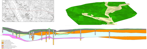
Geoscientific research at the BGS has developed techniques to enable 3D geological modelling of the subsurface using software (GSI3D™). This has enabled the development of 3D conceptual models, including artificial ground, at city-wide scales but it is not used yet for archaeological models. Geological surveying in the Vale of York has provided a framework 3D geological model for parts of the city of York. Drawing on the success of the work in Bryggen (de Beer & Matthiesen, Citation2008) for integrated modelling, preliminary work was undertaken to develop a conceptual model of the combined geological and anthropogenic evolution of York. The result of this preliminary attempt to correlate existing geological data from boreholes in York with archaeological data for a period up to 1990 and held by the city revealed the uneven distribution of each data set and inaccuracies in height data. The BGS model was based on height data from Ordinance Survey mapping (5 m contours) whereas the archaeological data was recorded by local grid and usually tied into the national grid by use of a Geographic Information System. As Figure demonstrates, this basic difference in the data resulted in a transect where the archaeology (green line) is seen lying above the ‘current ground surface’ in the geological model but also below the geological formations themselves.
It is however the case that this type of difference is to be expected for data gathered in different ways at different times and for varied purposes. The widespread recording of heights on manhole cover heights across the city and the recording of Lidar data in the flood plain both offer solutions to the methodological problems and will allow a transformation of the data already held. The disjuncture seen at York between geology and archaeology has been recognized elsewhere. Ken Hamilton's The Great Yarmouth Archaeological MapFootnote3 produced a 3D deposit model for up to 4 m of subsurface deposits and ground-truthed the accuracy of the model by the use of ground penetrating radar. When the model was compared to a previously prepared geological model (based on 171 BGS boreholes from 1840 to 2005), there were substantial differences in the palaeotopography revealed. This probably relates to the lack of choice over borehole location for the BGS model, the lack of archaeological input, the lack of dating evidence and the lack of control over borehole quality (Hamilton, personal communication).
Preservation Potential
Much of the deposit modelling research has an implicit value attached to the preservation potential of any given deposit, and experience suggests that the presence of deep organic urban deposits is the most valuable resource which heavily influences our ability to interpret deposits; it is richer but it also enhances the legibility of the sequences (Carver, Citation1987, p. 9). Detailed work outlining the deleterious effects of hydrological changes and chemical alteration on the preserved archaeological deposits in York have been published (Maxfield et al., Citation2004; Holden et al., Citation2006, Citation2009). Environmental change caused by urban development, drainage, agriculture or climate alteration may cause the accelerated decay of archaeological remains and the quality and quantity of data recorded about the chemical and hydrological elements need to be improved with work placed securely in a geological and topographical context (Holden et al., Citation2006). In York, the effects of mechanical piling as a means of preservation in situ (with the 5% mitigation rule) have been discussed in the archaeological literature and the subsequent monitoring programme have been questioned (Davis et al., Citation2002).
For waterlogged deposits in the UK, a summary of findings has recently been published which brings together 60 episodes of monitoring waterlogged archaeological sites, and almost all of these episodes considered water level, pH and redox (Williams, 2012). Whilst not differentiating urban sites from the (majority of) rural sites, this review finds that project design for monitoring episodes is not adequately considered at the outset of the development project, and the wider hydrological landscape is insufficiently characterized before the commencement of long term monitoring projects which appear to constitute ad hoc arrangements. In cities, these problems are magnified because although the monitoring can identify the degradation of sub-surface cultural deposits, the methods to remedy this (for example the demolition of nearby buildings) are not achievable and this calls into question the purpose of monitoring schemes overall (Williams, 2012, p. 453).
The use of urban geological information in combination with archaeological knowledge has given vital information about the UNESCO World Heritage Site, Bryggen in the city of Bergen, Norway. A programme of intensive monitoring has identified problematic movements caused by a deterioration of underlying cultural deposits. A combination of lowering the ground-water level and an increased content of oxygen in the cultural layers has led to damage in the wooden historical structures and the loss of substantial amounts of cultural deposits each year (de Beer & Matthiessen, Citation2008). The focus of the monitoring programme has been on chemistry and also on the quantity of groundwater in the saturated and unsaturated zone, as well as recording movement rates for buildings. There is a significant correlation between the deposit preservation status and the variable groundwater flow dynamics across the site. The investigations demonstrated that groundwater and soil-moisture monitoring, and 3D indicative modelling, are potentially beneficial actions to improve our understanding of preservation conditions and the protection of archaeological deposits in situ (de Beer & Matthiessen, Citation2008).
Future Prospects
There are a number of challenges that models now need to address and accommodate in order to move forward with the deposit modelling capabilities. A great deal of data has been generated during two decades of intensive evaluation, and the scope of recording is now on a wider basis where the relationship of the deeply stratified urban core with suburban areas, e.g. a deeply-stratified ‘historic core’, is continuous with shallow rural sites.
There are now wider definitions of what constitutes archaeology and this includes standing buildings and industrial archaeology on ‘brownfield’ sites which had not been considered in earlier models. There is a changing conceptualization of the threat to archaeology from either flooding or from desiccation. Recent changes in legislation have significant impact with the planning guidance phrase ‘preservation in situ’, which has shaped much of the work for the last 30 years, now defunct and replaced in the new guidance by the notion of ‘the conservation of heritage assets’ (Malim & Panter, Citation2012, p. 430). The new Planning Policy Statement 5 (2010) gives greater selectivity to the sites investigated based on perceptions of significance; this requires us to have a good understanding of the resource itself and for current structures to accurately represent the interests of all stakeholders.
Deregulation and policy shifts towards localism have precipitated and increases the need for widened access, with not only the growth of community engagement and competing excavation companies but also governmental agendas for ‘local’ participation in the planning system, although as noted (Allmendinger & Haughton, Citation2013, p. 7) such activity will be likely be tightly circumscribed within existing frameworks. Participatory practice within planning practice has been examined over a long period and the role and efficacy of stakeholder involvement debated (Arnstein, Citation1969; Baker et al., Citation2007). In contrast to the proposal that UK spatial planning has only recently been tied to neoliberal political mechanisms (Haughton & Allmendinger, Citation2013, p. 3), the governance of the historic environment has long been seen as being related to a neoliberal political philosophy (Cooper, Citation2010). Recent advances in the participatory concepts of spatial planning in relation to the characterization of the historic environment have been proposed which may see citizens taking a more active role (Dobson & Selman, Citation2012). Indeed this is imperative if we are to minimize the fragmentation already described (Jongman, Citation2002) and is desirable if we want to achieve an overarching planning goal—to reconnect fragmented landscapes as both physical and social entities (Selman, Citation2012, p. 4).
In addition to changes in archaeological methods there is now a broadening of the conceptual apparatus to include well-developed research agendas, extended chronologically (to include deindustrialization and the twentieth century) and intellectually (for example in relation to suburbs and town/hinterland studies). There are issues within producing archaeological signatures including the identification of ‘typically’ urban activities; animal penning, cultivation and dumping within towns can yield aspects of rural landscape character and result in urban stratigraphic gaps (Macphail, Citation1994, p. 13). The application of historically defined chronologies and categories can be problematic in that the changes within defined periods may be greater than those evident between different time periods (Miller, Citation1997, p. 38). Characterizing sub-surfaces that represent thousands of years of human activity is a challenge and Carver (Citation1987, p. 18) has proposed a scheme which considers an assessment of preservation, feature spacing and deposit status as the most comprehensive way of categorizing urban deposits. There is a fundamental distinction is between constructional and erosional events. Within the former, geologists have distinguished between made, worked, infilled, disturbed and landscaped (all encompassed by the catch-all category ‘artifical ground’) and this model is applied in a regionally variable manner (Ford et al., Citation2010, p. 3). These categories do not match archaeological categories nor do they map onto curatorial/research interests. An adaptable new schema is proposed for the geological mapping of artificial ground which gives an hierarchical system and allows more nuanced and process related categories to be used (Ford et al., Citation2010, p. 6). The enhanced classificatory system of artificial ground is a response to urban work by BGS which emphasizes the complex and variable processes of landscape evolution (Ford et al., Citation2010, p. 12).
Humanly induced changes in the earth systems are now so rapid and immense that a new period of geological time ‘The Anthropocene’ is being debated as a possible geological phenomenon on the same scale as some of the great events of the Earth's deep past but with the catalyst for change routed firmly in human activity, whether social, political or economic (Zalasiewicz et al., Citation2011). As part of this reconceptualization, the role of the human stratigraphic signal becomes significant as the impact of humans on geomorphological regimes make a substantial impact moving large volumes of deposits in the UK (Price et al., Citation2011). The range of human action to shape the landscape by truncation, erosion or deposition is highly variable and complex; artificial ground was not shown on geological maps until the 1960s becoming part of the routine suite of surveying/recording in the 1990s (Price et al., Citation2011, p. 1068). The way that artificial ground is characterized requires detailed knowledge of the landform and the physical, sedimentological and lithological context (Price et al., Citation2011, p. 1068). Apart from the geological representation of ‘infilled ground’, it is often not possible to represent a range of different phases of human activity that may have occurred in a single location (Price et al., Citation2011, p. 1068), and in urban conurbation (e.g. Manchester), mapped artificial ground can cover almost 18% of the land surface (Price et al., Citation2011, p. 1073). It is germane to this discussion of the significance of deposits for urban space that when the City of York submitted an (ultimately unsuccessful) bid to be designated a UNESCO World Heritage Site in 2011 the sub-surface deposits were afforded the same status in the cultural offer as the highly visible historic buildings and museums, archives and collections, the deposits constituting part of an ‘outstanding universal value’ (City of York Council, Citation2011).
Conclusions
There are a number of substantial challenges to urban deposit modelling, particularly those relating to monitoring regimes and micro-topographic resolution. Depositional setting, hydrology and water chemistry must be studied together and more robust data collected to test models. Advance planning at the project design stage for archaeological remains in urban development is essential for the sponsor and for the fieldworkers, but often, developers will only pay for the areas which will be damaged directly (Carver, Citation2009, p. 183). The concentration of archaeological research within the planning system (under PPG16) has necessarily resulted in many small scale investigations which were not conventionally published and which did not focus on synthetic understanding nor to a broader archaeological corpus; this problem is more acute for deeply stratified urban sites (Miller, Citation1997, p. 18; Grenville, 2001, p. 132). New guidance based on the ‘significance’ of the historic environment is of concern for planning practice if we consider concerns about the ways curatorial and planning decisions are reached (Li & Hamin, Citation2012) and our need to reconnect societies with landscapes through sustainable planning practice (Selman, Citation2012). Interdisciplinary approaches to complex urban problems, such as characterizing the sub-surface, seem to offer the most benefits.
Combining the shallow (archaeological) deposits with the deeper (geological) deposits in a single sub-surface model which allows the research interests of both disciplinary groups and encompasses the needs of other stakeholders (planners, communities, local authorities) is our aim. This type of approach not only dispenses with the need for deposits to be logged by ‘geologically competent archaeologists’ (Wilkinson et al., Citation2013) but enhances our understanding of processes, natural and cultural, to broaden our conceptual apparatus. The changes proposed by geologists to evaluating artificial ground and the debate around the Anthropocene demonstrate that an interdisciplinary approach is the only way to successfully develop models which can deliver more robust data and draw most effectively on a combination of expertise.
Acknowledgements
The author acknowledges the significant contribution of a number of colleagues to this discussion: Steve Roskams (University of York), Simon Price (British Geological Survey) and John Oxley (City of York Council). Grateful thanks to Ken Hamilton, Hans de Beer, Pete Connelly and Helen Goodchild.
Notes
1.http://www.english-heritage.org.uk/publications/nhpp-plan-framework/
2.http://www.english-heritage.org.uk/professional/protection/national-heritage-protection-plan/plan/activities/3a5, NHPP Activity 3A5 Wetland and Waterlogged Heritage Survey.
3.http://www.heritage.norfolk.gov.uk/gyam
Related Research Data
REFERENCES
- Allmendinger, P., & Haughton, G. (2013) The evolution and trajectories of English spatial governance: neoliberal episodes in planning, Planning Practice and Research, 28(1), pp. 6–26.
- Andrews, G. (1984) Archaeology in York: an assessment, in: P.Addyman & V. E.Black (Eds) Archaeological Papers from York Presented to MW Barley, pp. 173–205 (York: YAT)
- Arnstein, S. R. (1969) A ladder of citizen participation, Journal of the American Institute of Planners, 35(4), pp. 216–224.
- Baker, M., Coafee, J., & Sherriff, G. (2007) Achieving successful participation in the new UK spatial planning system, Planning Practice and Research, 22(1), pp. 79–93.
- Biddle, M., & Hudson, D. (1973) The Future of London's Past: A Survey of the Archaeological Implications of Planning and Development in the Nation's Capital (London: RESCUE Publication 4)
- Carver, M. O. H. (1987) The nature of urban deposits, in: J.Schofield & R.Leech (Eds) Urban Archaeology in Britain, pp. 9–26, CBA Research Report 61. https://doi.org/doi:10.5284/1000332.
- Carver, M. (2009) Archaeological Investigation (Abingdon: Routledge)
- City of York Council (2011) World Heritage Site Application. Available at http://www.york.gov.uk/downloads/file/3600/city_of_york_world_heritage_site_application. Consulted May 2013.
- Cooper, M. (2010) Protecting our past: Political philosophy, regulation, and heritage management in England and Scotland, The Historic Environment, 1(2), pp. 143–159.
- Corcoran, J., Halsey, C., Spurr, G., Burton, E., & Jamieson, D. (2011) Mapping Past Landscapes in the Lower Lea Valley: A Geoarchaeological Study of the Quaternary Sequence (London: MOLA)
- Cullingworth, B., & Nadin, V. (2006) Town and Country Planning in the UK (Abingdon: Routledge)
- Davis, M., Hall, A., Kenward, H., & Oxley, J. (2002) Preservation of urban archaeological deposits: Monitoring and characterisation of archaeological deposits at Marks & Spencer, 44-45 Parliament Street, York, Internet Archaeology, 11, http://intarch.ac.uk/journal/issue11/oxley_index.h.
- de Beer, H., & Matthiesen, H. (2008) Groundwater monitoring and modelling from an archaeological perspective: Possibilities and challenges, in: T.Slagstad (ed.) Geology for Society, pp. 67–81. Geological Survey of Norway Special Publication, 11.
- Dobson, S., & Selman, P. (2012) Applying historic landscape characterization to spatial planning: From remnants to remanence, Planning Practice and Research, 27(4), pp. 459–474. 10.1080/02697459.2012.680268.
- English Heritage (2013) Exceptional Waterlogged Heritage Stage 1 Report. Available at https://www.english-heritage.org.uk/publications/6240-exceptional-waterlogged-heritage-stage1-inventory/. Consulted March 2014.
- Ford, J., Cooper, A. H., Price, S. J., & Hummpage, A. J. (2010) . British Geological Survey Open Report, OR/10/036. Available at http://nora.nerc.ac.uk/10931/1/OR_10_036_updated.pdfAn Enhanced Classification for Artificial Ground.
- Giles, C., & Thomas, R. M. (2010) Thematic Research Strategy for the Urban Historic Environment (London: English Heritage)
- Haughton, G., & Allmendinger, P. (2013) Spatial planning and the new localism, Planning Practice and Research, 28(1), pp. 1–5.
- Holden, J., Howard, A. J., West, L. J., Maxfield, E., Panter, I., & Oxley, J. (2009) A critical review of hydrological data collection for assessing preservation risk for urban waterlogged archaeology: A case study from the City of York, UK, Journal of Environmental Management, 90, pp. 3197–3204. 10.1016/j.jenvman.2009.04.015.
- Holden, J., West, L. J., Howard, A. J., Maxfield, E., Panter, I., & Oxley, J. (2006) Hydrological controls of in situ preservation of waterlogged archaeological deposits, Earth Science Reviews, 78, pp. 59–83. 10.1016/j.earscirev.2006.03.006.
- Jongman, R. H. G. (2002) Homogenisation and fragmentation of the European landscape: Ecological consequences and solutions, Landscape and Urban Planning, 58, pp. 211–221.
- Li, N., & Hamin, E. M. (2012) Preservation, in: R.Crane & R.Webster (Eds) Oxford Handbook of Urban Planning, pp. 181–196 (Oxford: OUP)
- Macphail, R. I. (1994) The reworking of urban stratigraphy by human and natural processes, in: A. R.Hall & H. K.Kenward (Eds) Urban-Rural Connexions: Perspectives from Environmental Archaeology, pp. 13–43 (Oxford: Oxbow Books)
- Malim, T., & Panter, I. (2012) Is preservation in situ an acceptable option for development control? Can monitoring prove the continued preservation of waterlogged deposits?Conservation and Management of Archaeological Sites, 14(1), pp. 429–441. 10.1179/1350503312Z.00000000037.
- Maxfield, E., Holden, J., Howard, A. J., West, J. J., & Lane, S. N. (2004) Predicting Impacts of Environmental Change on Surface–Subsurface Hydrological Interactions in Sensitive Urban Environments (London: English Heritage)
- Miller, P. (1996) Digging deep: GIS in the City, Analecta Praehistorica Leidensia, 28, pp. 369–376. Available at http://proceedings.caaconference.org/files/1995/44_Miller_CAA_1995.pdf.
- Miller, P. (1997) The York archaeological assessment, Unpublished PhD thesis, Department of Archaeology, University of York.
- Neal, C. (2003) The river system in York: Towards an archaeological understanding, Unpublished Dissertation, Department of Archaeology, University of York.
- Ove Arup and Partners (1991) York Development and Archaeology Study (London: English Heritage)
- Price, S., Ford, J., Cooper, A., & Neal, C. (2011) Humans as major geological and geomorphological agents in the Anthropocene: The significance of artificial ground in Great Britain, Philosophical Transactions of the Royal Society A, 369(1938), pp. 1056–1084.
- Roskams, S. (1996) Urban transition in early Medieval Britain: The case of York, in: N.Christie & S. T.Loseby (Eds) Towns in Transition, pp. 262–287 (Aldershot: Scholar Press)
- Roskams, S. (2001) Excavation (Cambridge: Cambridge University Press)
- Roskams, S. (2003) Urban archaeology in Yorkshire, in: T.Manby, S.Moorhouse & P.Ottaway (Eds) The Archaeology of Yorkshire: an assessment at the beginning of the 21st century. Proceedings of the Yorkshire Archaeological Research Framework Forum, pp. 369–376 (Leeds: Yorkshire Archaeological Society)
- Schofield, J., & Leech, R. (1987) Urban Archaeology in Britain, CBA Research Report 61. https://doi.org/doi:10.5284/1000332.
- Selman, P. (2012) Sustainable Landscape Planning: The Reconnection Agenda (Abingdon: Routledge)
- Sidell, J., Wilkinson, K., Scaife, R., & Cameron, N. (2000) The Holocene Evolution of the London Thames (London: MOLAS)
- Ward, S. V. (2004) Planning and Urban Change (London: Sage)
- Wilkinson, K., Jones, B., & Meara, R. (2013) Distribution and Significance of Urban Waterlogged Deposits in Bristol, EH Project 6517 (London: English Heritage)
- Zalasiewicz, J., Williams, M., Haywood, I., & Ellis, M. (2011) The Anthropocene: A new epoch of geological time?Philosophical Transactions of the Royal Society A, 369(1938), pp. 835–841.