
Abstract
The central focus of this paper is to highlight the ways in which path dependencies and increasing returns (network effects) serve to reinforce carbon lock-in in large-scale road transportation infrastructure projects. Breaking carbon lock-in requires drastic changes in the way we plan future transportation infrastructure projects, and documentary evidence presented here from the metropolitan regions of Copenhagen, Denmark and Portland, USA, indicate that there may be a discontinuity in the system of automobility (Urry, 2004), thereby increasing the likelihood that such drastic measures may in fact be successfully realized.
Introduction
Transportation and land use planners are increasingly faced with a multitude of overlapping, and often contradictory, choices when developing long-term strategic visions for low-carbon urban futures. Aggressive carbon reduction goals in the transport sector often collide with economic development and political goals that prioritize automotive mobility as the key to wealth creation and regional accessibility (Newman & Kenworthy, Citation1996). Despite more than two decades of sustained efforts at the urban and regional scales, carbon emissions from the transport sector have continued to rise across the globe (Banister, Citation2011), and one of the primary causal explanations posited in this paper is the role of socio-technical and institutional path dependencies that lead to carbon lock-in (Unruh, Citation2000).
This paper examines the role of path dependencies in conditioning future low-carbon transport options. As will be discussed below, past path dependencies can exert a strong influence on present and future choices in a number of ways that are not currently taken into account in large-scale transportation infrastructure planning. First, there is a very real danger of socio-technical lock-in to an inferior transport system (Bertolini, Citation2007). All other things being equal, the mobility and land use consequences for road and rail projects have widely divergent impacts upon, among other things, the density, transport mode choice and overall carbon impact within an urban region (Newman & Kenworthy, Citation1996; Cervero, Citation2003; Næss, Citation2005). Second, it is overwhelmingly evident at this juncture that radical interventions will be necessary in order to escape carbon lock-in in the transport system. As long as planners treat road, rail and non-motorized transport modes as fungible goods, then it is likely that the existing path dependencies will reinforce and reproduce a high-carbon transport system.
Through the use of descriptive content analysis, two cases from the metropolitan regions of Portland, the USA, and Copenhagen, Denmark are used as illustrative examples of how path dependencies and increasing returns serve to reinforce existing carbon-intensive transport modes despite aggressive greenhouse gas (GHG) reduction strategies in place and high levels of investment in collective transport, walking and cycling. However, the findings from the cross-case analysis suggest that the existing automobile-centred planning system may be undergoing a seismic shift away from the predict-and-provide paradigm (Owens, Citation1995), thereby providing an opening for new path creation around low- or no-carbon modes of transport.
Path Dependency, Increasing Returns and Climate Change
In order to break the current GHG emission trends, the existing development trajectory of society will need to change radically in order to create a low-carbon future (Unruh, Citation2002; Sathaye et al., Citation2007). GHG emissions from the transport sector comprise 22% of worldwide carbon emissions, and 30% and rising in OECD countries (International Energy Agency, Citation2012). The International Energy Agency notes that ‘[g]lobal demand for transport appears unlikely to decrease in the foreseeable future; the World Energy Outlook (WEO) 2012 projects that transport fuel demand will grow by nearly 40% by 2035’ (International Energy Agency, Citation2012, p. 63). The existing system of transport has become locked in to a carbon-intensive system that exhibits strong path dependencies and is characterized by increasing, rather than decreasing, returns (Unruh, Citation2002).
Following Pierson (Citation2000), path dependency is defined as a self-reinforcing process by which each step along a given path increases the likelihood of further steps in the same direction. A fundamental aspect of this definition is that once certain thresholds are reached, the costs of reversal or path alteration become prohibitively high, leading to socio-technical and institutional lock-in. There are points of inflection that allow for shifts in policy and direction, but due to high structural and institutional barriers that get reinforced through time and practice, it is extremely difficult to effect systemic change absent large exogenous shocks or behavioral change.
Path dependencies are closely linked to the law of increasing returns. Increasing returns are characteristic of nonlinear, multiple equilibrium systems where marginal costs fall, and benefits increase due to network effects and scaling (Arthur, Citation1994). According to Pierson (Citation2000), there are four features of the relationship between technology and society that are likely to generate increasing returns: (1) the presence of large set-up or fixed costs, (2) learning effects, (3) coordination effects and (4) adaptive expectations.
The path dependencies of the existing system of automobile-based mobility illustrate the principle of increasing returns (even at the point of lowering the long-range viability of economic, social and ecological systems) and have important implications for planning strategies to tackle climate change. The existing architecture of what Urry (Citation2004) terms ‘automobility’ is the result of a number of complex interactions between technological, socio-economic and political forces that has resulted in a particular arrangement that has persisted for over a hundred years. The large fixed costs of operations, maintenance and capital requirements of the production, service and distribution networks create a strong incentive to maximize output (and profit) over a long period of time to lower the high initial costs of planning, construction and operation. The complexity of the network yields a similar logic of maximizing returns due to the high initial learning curve. Modern, centralized planning for automobiles is technically demanding and has required its owners (typically the state, but also increasingly private companies) to spend many years becoming proficient, which in turn leads to focusing on optimization of the existing system rather than seeking out disruptive new innovations in transport planning.
The associated ecosystem of infrastructure suppliers for automobiles also creates powerful coordination effects. The infrastructure of automobility has strong positive externalities that draw in many other sectors creating an inter-linked network of dependency. Fundamental changes in the underlying architecture of automobile-based mobility threaten these relationships, creating a reinforcing cycle of reliance upon a very specific mode of transport. Finally, adaptive expectations play an important role in maintaining the existing technological path, in that the aggregate expectations of future developments can establish self-fulfilling prophecies.
The relevance of path dependencies and increasing returns to large-scale transportation infrastructure planning detailed in the following case studies will focus on two inter-related issues: induced demand and changes in land use. The exclusion of induced demand in ex-ante project assessments can generate wildly inaccurate assessment of travel-time savings (Goodwin, Citation1996; Cervero, Citation2003) leading to sub-optimal investment decisions. Induced demand is defined here as new traffic volume that results directly from the provision of new infrastructure (Litman, Citation2012). A recent study in Copenhagen demonstrated that modeling a 5% increase in induced demand in a dense urban area can wipe out nearly 40% of the projected travel time savings and lead to projected increases in CO2 emissions that are 75% higher than compared to model runs that exclude induced demand (Næss et al., Citation2012). Changes in land use are closely linked to transport modal choice, whereby automobile-based systems typically result in low density, carbon-intensive residential/firm location decisions and transport behavior (Newman & Kenworthy, Citation1996; Ewing & Cervero, Citation2010; Banister, Citation2011).
In sum, the basic problem addressed here is that despite nearly two decades of effort at the regional and municipal levels, carbon emissions from the transport sector continue to rise around the globe, and a central explanatory hypothesis is that path dependencies and increasing returns are a major contributory factor. The guiding research question investigated is: To what extent are the path dependencies of carbon-intensive modes of transport reflected in the large-scale transportation planning and investment goals of the city-regions? The following section describes the primary methods employed in the comparative case study, including case selection criteria, data collection and analysis techniques, and the limitations of the study.
Methods
The empirical data presented here are derived from a larger comparative case study investigating decision-making and climate change planning in the regions of Copenhagen, Denmark and Portland, USA. In selecting the case city regions, the author employed a number of criteria, including: (1) similar demographic and socio-economic profiles, (2) strong land use/transport planning institutions, (3) multi-decadal engagement with climate change planning issues, (4) extensive citizen involvement in municipal and regional planning, (5) strong historical focus on sustainable urban development and (6) similar climatic challenges.
Empirical data sources are primarily textual, conducted using both desk research and on-site participant observation data collection from the period between 2010 and 2014. Documents reviewed included: multiple generations of climate change mitigation strategies (municipal, regional, state and national), regional transportation investment plans, regional transportation strategies, comprehensive regional development strategies, project-level environmental impact assessments and cost-benefit assessments, state and national audit reports, and media reports. In addition, statistical databases and travel survey data were accessed for background figures of traffic counts and mobility patterns at the regional level.
Path dependencies can be found in all forms of transport infrastructure, including low- or no-carbon modes such as walking, biking, light rail and heavy urban rail. For the purposes of this paper, however, two large-scale transportation infrastructure projects were selected based upon their carbon-intensiveness: the proposed Ring 5 motorway project in the Copenhagen region and the proposed Columbia River Crossing in the Portland/Vancouver region. A theoretical sampling technique (Yin, Citation2009) was used to select these two examples, built upon the following logic. The Copenhagen and Portland Metropolitan regions are recognized leaders in municipal and regional carbon reduction strategies, and it is posited that due to their front-runner status, the transportation planning regimes would be cognizant of carbon-related path dependencies of large-scale projects such as new highway or fixed link road infrastructure projects.
Since the empirical work is drawn from primarily textual sources, there is a limited amount of triangulation that was possible; therefore, the overall validity of the findings should be understood with this in mind. Also, possibility of selection bias cannot be ignored, but the sampling techniques were necessarily limited by the constraints of the larger research project.
The Copenhagen Region Case
The City of Copenhagen has set itself the goal of reducing CO2 emissions by 20% in the year 2015, based on 2005 emission levels. This target is intended to be a stepping-stone toward creating a carbon-neutral city by 2025 (City of Copenhagen, Citation2009, Citation2012). All but three of the municipal governments within the Greater Copenhagen region have voluntarily committed themselves to a 2% annual reduction in CO2 emissions (Danmarks Naturfredsforening, Citation2013). The Capital Region of Denmark has a climate strategy as well, but there are no concrete CO2 reduction targets established within the strategy (The Capital Region of Denmark, Citation2011a, Citation2011b). The Danish Government in 2009 established a goal of reducing CO2 emissions from the transport sector by 20% in 2020 (The Danish Government, Citation2009). In the Capital Region of Denmark, there are two countervailing trends. One, within the municipalities of Copenhagen and Frederiksberg, there are indications of significant shifts in the local transport path dependencies supported by increasing cycling, walking and public transport provision while parking spaces are reduced and streets are shared with non-motorized means of transport (City of Copenhagen, Citation2014).
Pushing against these trends, however, are rising levels of car ownership (Statistics Danmark, Citation2010, Citation2012) rising levels of cross-commuting and reverse commuting patterns (City of Copenhagen, Citation2005; The Capital Region of Denmark, Citation2008), high costs of housing within the central core and regional development policies that are biased toward expansion of the road network at the expense of rail and bus. Until recently, the dominant development pathway in the region was towards low-density car-dependent sprawl that is nearly certain to generate higher GHG emissions from both the built environment and transport sectors.
The capital region of Copenhagen has one of the lowest rates of public transport use and highest car modal share (82%) of any European capital city (The Capital Region of Denmark, Citation2008). Nowhere in the transportation section of the Regional Development Plan do planners address the connection between capacity expansion of roadways, airports and shipping facilities and increasing GHG emissions. The regional development plan notes that:
The traffic-related development in the Capital Region has become increasingly complex and today is far more spread geographically than before. The relocation of workplaces from central Copenhagen and spread of residential areas further out the city fingers has resulted in an increasing need for traffic connections across the Region. (The Capital Region of Denmark, Citation2008, p. 36)
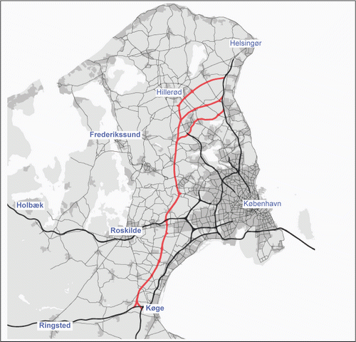
The regional development and investment plans push for on-going capacity expansion of the ring roads and motorways, noting that traffic volumes on the existing network have grown by 25–30% in the last decade (The Capital Region Denmark, Citation2011). The real or perceived need to relieve congestion creates a logic of continual road capacity expansion, such as the 60-km long multi-modal Ring 5 motorway/railway project, at a projected cost of 19 billion DKK ($3.4 billion, €2.5 billion) (The Capital Region Denmark, Citation2011). Among the proposed investments in road and rail, notably absent is any meaningful action to reduce distances traveled, introduce mobility restrictions or implement demand management policies to reduce overall carbon emissions from the transport sector. The Danish Infrastructure Commission, a national advisory body that was tasked in 2006 to analyze and advise the government on priority investments in transport infrastructure that would ensure good service levels of road and rail mobility toward 2030, also relies on both congestion-relief and economic rationales to outline the need to continue to strengthen the motorway network.
For many years, the Danish infrastructure has been developed on the basis of the vision of “the large H”, which connects north, east, south and west with effective road and rail connections and ensures connections to other countries. The large H has proved its robustness, and the H should continue to form the solid basis for the development of our infrastructure. (The Danish Infrastructure Commission, Citation2008, p. 308)
Each major capacity expansion of the roadway network, from the connection between Zealand and Fyn, the Øresund link between Malmo and Copenhagen and now the Fehmarn Belt between Germany and Denmark all create a logic of increasing returns and adaptive expectations of further capacity expansions. More road capacity induces more demand, more drivers lead to higher levels of congestion, necessitating more capacity expansions to the road network, which opens up new transport connections in previously rural areas with low land values and better connectivity to employment, residential and leisure activities. The resultant low-density sprawl and high automobile use result in rising GHG emissions and contribute to the continued outward expansion of the urbanized areas and simultaneously creates unfavorable conditions for public transport due to the large distances and low population densities of these areas (Næss, Citation2011a, Citation2011b).
The construction of the Fehmarn Belt between Puttgarden in Germany and Rødby in Denmark will also have significant effects on the road network and urban development of both the city of Copenhagen and the entire Capital Region (Rambøll Consulting, Citation2010). The OECD notes that, as a result of the construction of the Fehmarn Belt:
Through-traffic is highly likely to increase and cause more pressure in the city centre of Copenhagen. To assure smooth transportation of goods and people, establishment of Ring 5, connecting Sjaelland and Helsingør and the physical link between Helsingør and Helsingborg, will be necessary in the long run. (Organization for Economic Co-operation and Development, Citation2009, p. 165)
A key feature of path dependencies within the transport system is that past decisions lay the ground work for future decisions in ways that constrain the possibilities for radically different physical, socio-economic, technical or institutional arrangements. As noted by the regional development plan:
In the long term, there is a need for another fixed link across the Oresund. The fixed Femern Belt link will, in combination with the expected development in commuting across the Oresund, increase the traffic-related pressure and thereby create a need for a fixed link between Helsingør [in Denmark] and Helsingborg [in Sweden]. This will also call for establishment of a new railway and road link in Ring 5. (The Capital Region of Denmark, Citation2008, p. 40)
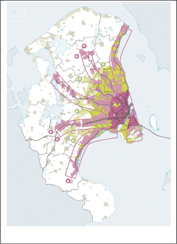
A comparison of the major investments in large-scale road infrastructure (Figure ) and the updated Finger Plan 2007 (Figure ) show two entirely divergent path dependencies, where the Ring 5 motorway project rides roughshod over the vision of dense transit-oriented development along the existing commuter rail corridors. The Fingerplan is intended to guide development toward public transport corridors and to preserve the green areas surrounding the urbanized zones. Ring 5 will establish development patterns that contradicts the Fingerplan, encouraging travel and location decisions that cut across the fingers, putting pressure on the green areas and surrounding farmland (Østergaard, Citation2010). In this case, existing path dependencies based on increasing returns do not specifically exclude the likelihood of significant changes in future development pathways, but the probabilities for change are remote if large-scale transportation infrastructure planning does not include measures to break carbon lock-in.
The traffic generated by the construction of the Fehmarn Belt creates a situation where the most viable and logical policy is to continue to build more and bigger connections to tie the road network together. The medium- to long-term planning implications of these decisions are not particularly difficult to divine. Despite the strong planning measures in place at both the municipal and regional scale to concentrate development close to public transport, the built-up urbanized areas will likely continue to expand, increasing the distances between the central city and the outer suburbs, drawing more low-density development to the fringes of the region, all of which will likely lead to higher future GHG emissions.
At the regional level, the continued expansion of the road network, combined with stagnating levels of support for the expansion and operation of public transport as well as increasing regional mismatches between residential location preferences and employment opportunities has led to development pathways that have high future GHG emission profiles. The high levels of initial investment in the road network, the high levels of technical know-how necessary to plan and operate the complex system, the strong coordination effects tying economic and social drivers to road expansions and adaptive expectations mean that cars will continue to dominate the transport system. These path dependencies will likely work against planning efforts to reduce overall travel and create more compact urban forms at the regional scale, despite the growing protests from affected communities within the proposed alignment (Larsen, Citation2013).
The Portland Region Case
The city of Portland has had a global warming strategy in place since 1993 (City of Portland, Citation1993), and the most recent iteration of the strategy, the Climate Action Plan (2009), sets out long-range strategic GHG reduction goals on the order of 40% by 2030 and 80% by 2050 (City of Portland; Multnomah County, Citation2009). Metro, the regional governing authority that coordinates land use and transportation across 3 counties and 25 cities in the Portland region, has been tasked by the Oregon State Legislature to reduce GHG emission from light-duty vehicles by 20% by 2035 (Metro, Citation2014). At the state level, the Oregon Legislature established through ORS 468A.205 statewide GHG emission reduction goals (using a 1990 baseline) of 10% reduction by 2020 and 75% reduction by 2050 (State of Oregon, Citation2007).
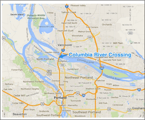
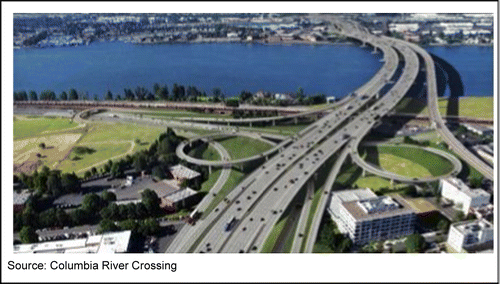
An interesting test case of how deeply committed the State, Metro and the cities in the region are to encouraging less carbon-intensive modes of travel is the Columbia River Crossing (CRC) project that has been in the planning stages since 2005 (Washington State Auditor's Office, Citation2014). The ageing lift-span bridge is a major regional lynchpin of the passenger and freight transportation system along the Interstate 5 corridor. In order to relieve congestion, the states of Oregon and Washington proposed to replace the six-lane bridge with a 10-lane bridge at an estimated cost of $3.6 billion USD. The bridge would also be built to accommodate an expansion of the light rail system into Vancouver as well as provide improved pedestrian and bike access Figures and .
In its current configuration with 6 travel lanes with a drawbridge to accommodate shipping traffic, the bridge carries approximately 124,000 vehicles per day (Oregon Department of Transportation, Citation2012). Projected average annual daily traffic, according to the Final Environmental Impact Assessment (FEIS), will be on the order of 178,000 vehicles a day by 2029 (Columbia River Crossing, Citation2011). However, since the original demand estimate was published in 2008, a number of critical reviews have found that due to lower economic growth projections, reduced population growth, changes in regional travel behavior and the added tolling necessary to pay for construction financing, revised Average Annual Daily Traffic (AADT) numbers for 2029 indicate that the bridge will carry between 93,000 and 137,000 vehicles a day (Bain, Citation2011; Cortwright, Citation2013).
There are two relevant points to raise here. First, the FEIS no-build represents what could be called ‘pessimism bias’ (Næss, Citation2011a, Citation2011b) whereby the zero-alternative was chosen to make the build option look better by comparison. An analysis conducted in 2013 found that
[I]n the fourth quarter of 2011, the project published its Final Environmental Impact Statement (FEIS). Even though six years had elapsed since the base period of its original forecasts (2005), the project did not revise the forecasts from the Draft Environmental Impact Statement. In fact, the Final Environmental Impact Statement contains no post-2005 traffic data: CRC planners simply ignored everything that happened after 2005, and stuck with their original forecasts. (Cortwright, Citation2013, p. 4)
Second, the imposition of tolling in 2016 is projected to have a dramatic impact on travel demand (although to what extent trips will be avoided or shifted to other parts of the network was not modeled) (Bain, Citation2011). This would seem to indicate that if the overarching goal of the region was to lower GHG emissions from the transport sector by reducing demand for car-based travel, tolling is by far a more effective strategy than capacity expansion.
A separate greenhouse gas analysis was conducted as a supplement to the FEIS concluding that the project will lead to lower GHG emissions than the no-build alternative (Columbia River Crossing, Citation2011). An analysis conducted by the Metro Regional government using an integrated land use/transport model, MetroScope, concluded that expanding road capacity by even 100% would not lead to any significant increase in induced demand, since the tolls would cancel out most of the new travel demand (Metro, Citation2010). However, as noted above, many of the assumptions regarding travel-time savings and travel demand have been overstated in the draft and final EIS (Bain, Citation2011; Cortwright, Citation2013). None of the ex-ante planning documentation that has been produced for the Columbia River Crossing project takes into account the path dependencies that arise from continued capacity expansion of the freeway network, particularly in relation to subsequent land use development.
There is an important symbolic dimension to planning decisions such as these. One of the underlying rationales for creating and implementing climate change strategies is that humanity needs to act quickly to dramatically lower GHG emissions within the next 10–15 years in order to begin to stabilize atmospheric GHG concentrations. The Columbia River Crossing, for example, undercuts that message and instead suggests that efficient freight and automobile movement is a much higher societal priority than lowering GHG emissions.
Many politicians on both the Washington and Oregon sides of the river pushed hard to get the necessary funding in place to meet deadlines for the Federal government contributions. Proponents of the bridge argued that the doubling of the travel lanes was necessary to relieve congestion and create better freight movement through the region. Opponents on both sides of the Columbia River used a number of arguments, including environmental and economic ones, to undercut the case for the project. Interestingly, one of the main sources of opposition from the Washington side was the presence of the light rail extension to Vancouver, which many of the Republican local politicians saw as a conspiracy by left-wing Portlanders to force Washingtonians out of their cars (Manning, Citation2014). The codex to this story is that in March 2014 the entire CRC project was shut down, after spending nearly $200 million on preliminary engineering, design, environmental assessments, traffic forecasts and cost–benefit assessments (Washington State Auditor's Office, Citation2014). The Washington State Legislature refused to allocate $450 million for Washington's contribution in 2013 (Read, Citation2013), and the Oregon Legislature could not agree on a financing modeling going forward without Washington in March 2014, effectively killing the entire project (Manning, Citation2014).
Cross-Case Analysis and Conclusions
Returning to the research question posed in the beginning of the article, the findings from both the Copenhagen and Portland regional cases suggest that the large-scale transportation planning documents do not significantly address the path-dependent aspects of carbon-intensive motorway/fixed link projects. Induced demand and associated land use changes that come along with large motorway projects (longer traveling distances, lower building densities, more dispersed development patterns) are either outright ignored or downplayed considerably in the traffic forecasts, environmental impact assessments and cost–benefit assessments for both projects.
Additionally, the initial hypothesis that well-developed climate change mitigation strategies at the national, state, regional and/or municipal levels would be a good predictor of the extent to which carbon-intensive infrastructure planning addressed the path dependencies of the existing systems was proven wrong. Both the regional and municipal governments in Portland and the municipal and national governments in Copenhagen had clear targets for carbon reductions in the transport sector, but they were not adequately reflected in the regional transportation investment priorities.
However, both the CRC project in the Portland region and the Ring 5 project in the Copenhagen region demonstrate that the former stability of large-scale transportation infrastructure planning may be undergoing a potentially dramatic shift, driven by a combination of environmentalism, economic austerity, an increasing skepticism toward the proclaimed benefits of new roads and changes in behavior (Ball & Schipper, Citation2011). For practicing planners, one of the key takeaways from this study is that we may be entering a period of instability in the existing system which offers an excellent opportunity to break carbon lock-in and develop new paths of low-carbon or no-carbon transport infrastructure.
Related Research Data
REFERENCES
- Arthur, B. W. (1994) Increasing Returns and Path Dependence in the Economy (Ann Arbor: Unversity of Michigan Press)
- Bain, R. (2011) Columbia River Crossing-Review of Traffic & Revenue Reports and Related Material (London: RBConsult)
- Ball, A. M., & Schipper, L. (2011) Are we reaching peak travel? Trends in passenger transport in eight industrialized countries, Transport Reviews, 31(3), pp. 357–378.
- Banister, D. (2011) Cities, mobility and climate change, Journal of Transport Geography, 19(6), pp. 1538–1546.
- Bertolini, L. (2007) Evolutionary urban transportation planning: An exploration, Environment and Planning A, 39, pp. 1998–2019.
- Cervero, R. (2003) Road expansion, urban growth, and induced travel: A path analysis, Journal of the American Planning Association, 69(2), pp. 145–163.
- City of Copenhagen (2005) Trafik og Miljøplan 2004 (København: Københavns Kommune)
- City of Copenhagen (2009) Copenhagen Climate Plan, The Short Version (Copenhagen: City of Copenhagen)
- City of Copenhagen (2012) KBH 2025 Klimaplanen (Copenhagen: City of Copenhagen)
- City of Copenhagen (2014) Bicycle Account 2012 (Copenhagen: City of Copenhagen)
- City of Portland (1993) Global Warming Reduction Strategy (Portland, OR: City of Portland)
- City of Portland; Multnomah County (2009) Climate Action Plan 2009 (Portland, OR: City of Portland; Multnomah County)
- Columbia River Crossing (2011) Final Environmental Impact Statement (Washington, DC: US Department of Transportation)
- Cortwright, J. (2013) Analysis of CRC Traffic Forecasts (Portland, OR: Impresa Consulting)
- Danmarks Naturfredsforening (2013) Klimakommuner [The Danish for Nature Conservation]. Available at http://www.dn.dk/Default.aspx?ID = 77 (accessed 18 May 2014, from Danmarks Naturfredsforening).
- Ewing, R., & Cervero, R. (2010) Travel and the built environment – A meta-analysis, Journal of the American Planning Association, 76(3), pp. 265–294.
- Goodwin, P. B. (1996) Empirical evidence on induced traffic – A review and synthesis, Transportation, 23, pp. 35–54.
- International Energy Agency (2012) World Energy Outlook 2012 (Paris: OECD/IEA)
- Larsen, I. (2013, November 6) Massiv modstand mod Ring 5 hos kommende lokalpolitikere [Massive opposition against Ring 5 among incoming local politicians]. Available at http://www.nejtilring5.dk/46907319 (accessed 18 May 2014, from Nejtilring5).
- Litman, T. (2012) Generated Traffic and Induced Travel-Implications for Transport Planning (Victoria: Victoria Transport Institute)
- Manning, J. (2014, March 07) Columbia River Crossing: ODOT to pull plug, bridge project is dead. Available at: http://www.oregonlive.com/business/index.ssf/2014/03/columbia_river_crossing_odot_t.html (accessed 18 May 2014, from Oregonlive).
- Metro (2010) Columbia River Crossing MetroScope Results Documentation (Portland, OR: Metro)
- Metro (2014) Climate Smart Communities Scenarios Project – Achieving Climate Goals Through Community Investment (Portland, OR: Metro)
- Næss, P. (2005) Residential location affects travel behavior – But how and why? The case of Copenhagen metropolitan area, Progress in Planning, 63, pp. 167–257.
- Næss, P. (2011a) ‘New Urbanism’ or metropolitan-level centralization, The Journal of Transport and Land Use, 4(1), pp. 25–44.
- Næss, P. (2011b) The third Limfjord crossing: A case of Pessimism Bias and knowledge filtering, Transport Reviews, 31(2), pp. 231–249.
- Næss, P., Nicolaisen, M. S., & Strand, A. (2012) Traffic forecasts ignoring induced demand: A shaky fundament for cost-benefit analyses, European Journal of Transport and Infrastructure Research, 12(3), pp. 291–309.
- Newman, P., & Kenworthy, J. R. (1996) The land use-transport connection, Land Use Policy, 13(1), pp. 1–22.
- Oregon Department of Transportation (2012) Traffic Volumes on State Highways (Salem: ODOT)
- Organization for Economic Co-operation and Development (2009) OECD Territorial Reviews: Copenhagen, Denmark (Paris: Organization for Economic Co-operation and Development)
- Østergaard, N. (2010, November 22) Politikere vil have tunnel og motorvej fra Helsingborg til Køge [Politicians prefer a tunnel and motorway from Helsingborg to Køge]. Available at http://ing.dk/artikel/politikere-vil-have-tunnel-og-motorvej-fra-helsingborg-til-koge-114152 (accessed 18 May 2014, from Ingenioren).
- Owens, S. (1995) From ‘predict and provide’ to ‘predict and prevent’?: Pricing and planning in transport policy, Transport Policy, 2(1), pp. 43–49.
- Pierson, P. (2000) Increasing returns, path dependence and the study of politics, The American Political Science Review, 94(2), pp. 251–267.
- Rambøll Consulting (2010) New Motorway and Railway on Ring 5-Screening Analysis (Skåne: IBU-Øresund)
- Read, R. (2013, June 30) Columbia River Crossing Implosion Invites Lessons, Closure and New Plans. Available at http://www.oregonlive.com/business/index.ssf/2013/06/columbia_river_crossing_implos.html (accessed 18 May 2014, from Oregonlive).
- Sathaye, J., Najam, A., Cocklin, C., Heller, T., Lecocq, F., Llanes-Regueiro, J., Pan, J., Petschel-Held, G., Rayner, S., Robinson, J., Schaeffer, R., Sokona, Y., Swart, R., Winkler, H. (2007) Sustainable Development and Mitigation, in: B.Metz, O.Davidson, P.Bosch, R.Dave & L.Meyer (Eds) Climate Change 2007: Mitigation. Contribution of Working Group III to the Fourth Assessment Report of the Intergovernmental Panel on Climate Change (Cambridge: Cambridge University Press)
- State of Oregon (2007) Oregon Strategy for Greenhouse Gas Reductions (Salem: State of Oregon)
- Statistics Denmark (2010) Key Figures for Transport 2009 (Copenhagen: Statistics Denmark)
- Statistics Danmark (2012) Statistisk Årbog 2012 [Statistical Yearbook 2012] (Copenhagen: Statistics Denmark)
- The Capital Region of Denmark (2008) Regional Development Plan 2008 (Hillerød: The Capital Region of Denmark)
- The Capital Region of Denmark (2009) Development of Collective Transport in the Capital Region of Denmark (Hillerød: The Capital Region of Denmark)
- The Capital Region Denmark (2011a) Investing in the Future: A Joint Traffic Proposal from Local Government Regional Council and the Capital Region Denmark (Hillerød: The Capital Region Denmark)
- The Capital Region of Denmark (2011b) Climate Strategy for the Capital Region (Hillerød: The Capital Region of Denmark)
- The Danish Government (2009) A Green Transport Policy (Copenhagen: The Danish Government)
- The Danish Infrastructure Commission (2008) The Danish Transport Infrastructure 2030: Summary in English (Copenhagen: The Danish Infrastructure Commission)
- Unruh, G. C. (2000) Understanding carbon lock-in, Energy Policy, 28(12), pp. 817–830.
- Unruh, G. C. (2002) Escaping carbon lock-in, Energy Policy, 30(4), pp. 317–325.
- Urry, J. (2004) The ‘system’ of automobility, Theory, Culture & Society, 21(4/5), pp. 25–39.
- Washington State Auditor's Office (2014) Columbia River Crossing Report (Seattle, WA: State of Washington)
- Yin, R. K. (2009) Case Study Research: Design and Methods, 4th ed. (London: SAGE Ltd.)