
Abstract
This article explores the use of surveillance technologies in planning enforcement. Using literature from surveillance studies, it explores the use of well-established and more recent ‘surveillance technologies’, including aerial photography, closed-circuit television and the Street View function in Google Maps. The article identifies the varying use of these technologies in planning enforcement and explains the reasons for this using concepts derived from surveillance studies.
Introduction: Exploring Surveillance Technologies in Planning Enforcement
This article explores the use of selected ‘surveillance technologies’ in planning enforcement in England. Local planning authorities engage in a range of surveillance activities to identify and investigate breaches of planning control. In England a breach of planning control may be either the carrying out of development without planning permission, or the failure to comply with a condition attached to a planning permission. Surveillance practices may be used to identify these breaches, or these practices may be used in the ongoing investigation of suspected breaches. Many enforcement activities are characterised by ‘embodied’ surveillance (Zurawski, Citation2005), such as carrying out site visits in person and gathering information on site. Yet traditional forms of surveillance are increasingly complemented by modern surveillance technologies. This article focuses on the use of ‘new’ technologies in planning enforcement using interviews with planning enforcement officers. The first section of the article outlines the character of planning enforcement in England. The second section uses elements of surveillance studies literature to establish a context for interpreting the everyday surveillance practices of local planning authorities. The section engages with ‘the new surveillance’ literature, which emphasizes the use of electronic and other technologies in extending and deepening surveillance practices (Marx, Citation1988; Lyon, Citation2007). The third section provides a ‘grounded investigation’ of use of surveillance (Haggerty & Ericson, Citation2006, p. 3) by exploring three widely used surveillance technologies in planning enforcement: aerial photography, closed-circuit television (CCTV) and geo-visual technologies characterised by Google Maps and, specifically, its Street View facility. The article documents how each is used in practice, explores the key issues associated with their use, and concludes with an assessment of the impact of these technologies on enforcement practices.
Compliance and Planning Enforcement
The effectiveness of a planning system depends partly on mechanisms for enforcing planning regulations. It also depends on the capacity and willingness of local planning authorities to use these mechanisms, which in England include various legislative powers to investigate, monitor and remedy breaches of planning control. Yet studies of planning enforcement in England usually portray local planning authorities as under-resourced and struggling to cope with the workload of investigating complaints of unauthorised development (McKay et al., Citation2003). Planning enforcement is also typically characterised as a bureaucratic and legalistic activity (Prior, Citation2000; Lai et al., Citation2007), delayed by technicalities and the demand for detailed evidence. Consequently, commentators express concern for the effectiveness of planning enforcement (Carnwath, Citation1989; Purdue, Citation2008). Nevertheless, research identifies a generally high degree of compliance in Britain with planning regulations, with the exception of conditions attached to planning permissions (Turland, Citation1990; McKay et al., Citation2003). Academic literature has focused on addressing this ‘compliance gap’ by designing better regulations to facilitate greater compliance with those regulations (Burby et al., Citation1998; McKay & Ellis, Citation2005; McKay, Citation2007). This compliance literature is complemented by other literature that explores planning and its enforcement as a mechanism of social control (Yiftachel, Citation1998; Harris, Citation2011). A common focus in these planning enforcement literatures is the effectiveness of the mechanisms for detecting and investigating breaches of planning control. The following section characterises these mechanisms as ‘surveillance’ activities.
Surveillance, Technology and ‘The New Surveillance’
Visibility is vital for governance. (Lyon, Citation2007, p. 63)
The word surveillance has various connotations, including negative ones of control, supervision and oppression. Yet Dandekar (Citation1990, p. 37) stated that ‘In a general sense, surveillance activities are features of all social relationships’. Consequently, surveillance activities feature as part of planning systems. The social relationship most relevant to the study of surveillance and planning enforcement is between the regulatory body and those regulated. In other words, it is the relationship between state and citizen, and between local planning authority and landowners, tenants or developers. The form of surveillance in this relationship is characteristically asymmetrical, with the state acting as surveillance agent and citizens and landowners acting as the objects of surveillance. This relationship is nevertheless evolving and can also be inverted or subverted. Dandekar (Citation1990) also explains that surveillance involves a wide range of activities, including collecting and storing information, supervising actions, and monitoring behaviour to facilitate compliance. These activities all form part of the everyday practices of planning enforcement carried out by local planning authorities (McKay et al., Citation2003, p. 329; Lai et al., Citation2007, p. 539). Yet McKay et al. (Citation2003, p. 331) identified that the surveillance and information gathering practices of local planning authorities are not well understood and that there is a need for research that explores the everyday, informal practices of local planning authorities in investigating breaches of planning control, including their surveillance practices. A study by Harris (Citation2013) highlighted ‘the significant role of the public in extending and complementing the surveillance capacity of local planning authorities’ (p. 193) through their engagement in ‘lateral surveillance’ (Andrejevic, Citation2005; Zurawski, Citation2005; Reeves, Citation2012), or the straightforward practice of people, residents and neighbours watching each other. The central focus of this article, however, is on state-driven and state-directed surveillance. This dimension of surveillance also has a long and established place in the surveillance studies literature. Governments have historically recorded and monitored citizens. Yet the state's harnessing of new technologies in its surveillance activities provides an interesting and more recent dimension to this (see Marx, Citation1988; Lyon, Citation2007).
The term ‘the new surveillance’ is often used to emphasize technological developments in supporting new forms of surveillance practices (Marx, Citation1988, chapter 10; Simon, Citation2005) and the considerable growth in recent decades of ‘technologically mediated’ surveillance (Lyon, Citation2007, p. 1). Many authors point out that societies have always been subject to forms of surveillance, but they also acknowledge that modern technologies have important implications for the form and character of surveillance, and enable ‘new forms and qualities of surveillance’ (Wood, Citation2007, p. 253). This ‘new surveillance’ has a series of characteristics that distinguishes it from more traditional forms of surveillance. Marx (Citation1988, p. 217) highlighted how it has the capacity to transcend distance and time, is more capital than labour intensive, and displays potential for decentralisation that enables wider participation in surveillance activities. Lyon (Citation2001, p. 61) has noted how public as well as private organisations have been driven to ‘seek technical solutions to the surveillance quest’ and tap into the potential of these technologies.
Caution is, however, required when exploring these surveillance technologies. Some authors claim that surveillance studies exhibit ‘an over-emphasis on starting with either technologies or institutions … and not enough emphasis placed on the human dimensions of surveillance’ (Wood, Citation2005, p. 474). This human dimension of surveillance is known to be especially significant in planning enforcement (Harris, Citation2013), yet there is very little understanding of the complementary use of surveillance technologies, with the exception of some studies addressing the use of aerial photography (Lo, Citation1973; Lai, Citation1998). This article complements studies of citizens’ engagement in ‘lateral surveillance’ with an account of regulators’ use of surveillance technologies for planning enforcement. This article therefore responds to calls for more nuanced, empirically based enquiry on the use of surveillance technologies in systems of regulation and governance (Ball & Haggerty, Citation2005, p. 136).
Haggerty and Ericson (Citation2000) utilize the concept of the ‘surveillant assemblage’ as a way of exploring the convergence of a series of separate surveillance systems into a wider framework for surveillance activity (see also Elwood & Leszczynski, Citation2011; Rapoport, Citation2012). Planning enforcement officers utilize a range of ‘technologies’, including building administrative files complete with written evidence such as letters of complaint, witness statements and memoranda of site visits and discussions with interested parties. These files may also incorporate visual materials such as location maps, site plans and printed copies of photographs taken on site using a camera. These written and visual materials—themselves facilitated by various technologies such as cameras and word processors—form the basis for planning enforcement officers' everyday work. The surveillance studies literature acknowledges these very basic means of organising information as a classic component of surveillance practices. Yet the surveillance studies literature also points to more recent or evolving technologies that are capable of being incorporated into the surveillant assemblage in planning enforcement. These technologies are aerial photography, CCTV and Google's geo-visual technologies, focusing principally on Google Maps and its Street View function. Together, they represent an interesting collection of technologies that have evolved over time, from the well-established use of traditional aerial photography, to the now extensive network of CCTV in towns and cities across Britain, and the recent web-based technologies provided by Google. These technologies also reflect the ‘ocular emphasis’ that is characteristic of surveillance studies, with its focus on seeing and visual imagery over other forms of surveillance data (Lyon, Citation2007, p. 47; Elwood & Leszczynski, Citation2011, p. 7). Technologies that facilitate the act of seeing are especially powerful as ‘seeing casts a particular power: it reveals the hidden, conveys precision and offers control to the observing eye’ (Perkins & Dodge, Citation2009, p. 547). It is clear that visual technologies that produce images—whether static or moving—play an important role in planning enforcement, in which there is a premium on producing evidence of physical structures being in place, of buildings being constructed, or of sites and buildings being used for particular purposes and at particular times. Perkins and Dodge (Citation2009, p. 547) even go so far as to state that visual images convey a form of ‘truth’. The following section explores the three surveillance technologies in turn. The empirical data in the following sections are based on telephone interviews with the principal planning enforcement officer in each of 23 local planning authorities in England.Footnote1 The sample of local planning authorities covers each of the administrative regions of England, with the most active local planning authorities selected in terms of use of enforcement notices and other formal instruments, and includes examples of councils operating in both urban and rural contexts. Each interviewee was asked a series of questions about the role of the public and the role of technologies in investigating and monitoring actual or reported breaches of planning control. Interviews were recorded and transcribed.
The Use of Surveillance Technologies in Planning Enforcement
Aerial Photography and the ‘View from Above’
Aerial photography has historically been used for many purposes, from military planning and warfare to commercial and professional uses, including land use and environmental planning. Following enhancements in aerial photography in the post-Second World War period, aerial photography became increasingly useful for urban planning. The distant and apparently objective ‘view from above’ resonated strongly with modernist planning approaches (Lo, Citation1973; Vidler, Citation2011). Lo (Citation1973) identified and anticipated a range of applications of aerial photographs in urban planning, from general survey of land uses through to estimation of the population of areas, and before long the aerial view became ‘institutionalized as a central tool of planning’ (Vidler, Citation2011, p. 661). Lo's (Citation1973) account did not specifically identify the use of aerial photography for identifying and investigating cases of unauthorised development, yet aerial photography is now a well-established component of investigating unauthorised development (Lai, Citation1998). Local authorities in England have traditionally commissioned ‘fly-overs’ of their areas, comprising photographic aerial surveys by aeroplane, to support a number of different functions. These surveys typically produce district-wide coverage of aerial imagery at a resolution where individual parcels of land and individual buildings could be identified, but not always clearly so. This degree of resolution to enable exploration of plots and structures is important for planning enforcement. There are, however, limitations affecting the use and value of aerial photography for planning enforcement. Photographic images are ‘static’, showing images at a point in time, as aerial surveys have historically been expensive to commission and have therefore been conducted infrequently. The frequency with which the interviewed local authorities in England commission surveys varies tremendously, from every couple of years to every 6–8 years. Aerial photographs are also susceptible to problems of interpretation, as well as open to questions about their admissibility as evidence in support of a prosecution (Lai, Citation1998). Consequently, Lai (Citation1998) argued that aerial images may be of illustrative value only, and that ‘ground methods’ for investigation—such as site visits—remain significant in investigating breaches. Despite these limitations, the interviews identified that aerial photographs are used in planning enforcement in a number of ways. The principal use of aerial images is to establish whether a reported use or physical development was in place when the survey was last commissioned. This allows local planning authorities to place a development within a time-frame and verify whether it has been carried out in the period since the last survey. In planning enforcement in England, they key issue is aligning the frequency of commissioning of surveys with the periods for securing immunity from enforcement action,Footnote2 so as to detect and act on breaches before development becomes lawful. One enforcement officer highlighted the frequent use of aerial surveys to establish how long a development had been in place, particularly in rural areas:
You get somebody call, they've noticed a mobile home on farmland and when you actually get into it you probably hear the same story that it's been there for a number of years. In that respect the aerial photograph helps a tremendous amount because you can certainly look back over the years at the aerial photographs and detect with some degree of certainty whether or not there was a caravan there in 1990, as they say, or not, so that's been a tremendous help to us.[9]
This statement highlights the value of a series of historic records at periodic intervals and the regular updating of aerial surveys. The release of information from a new survey is also an opportunity to proactively monitor sites where on-going issues have been reported:
we've years of aerial photographs on our computer system, and I'd probably say on a daily basis we are looking at those … when a new disc comes out you're always keen to have a look to see if there's any glaringly obvious things to look at in known problem areas.[9]
Surveys provide a comprehensive but static picture of the administrative area. The use of Geographic Information Systems allows ‘layering’ and comparison of subsequent surveys to detect changes that occur between surveys. Systematic surveys are sometimes supplemented by other forms of aerial photography and imagery, including targeted surveillance of specific sites. These include sites known to be problematic, sites with a track history or sites deemed to be too risky to visit in person. One local authority, when asked if it used aerial photography, replied:
Yes, we use aerial photography very heavily. We hire a private plane about every two months and do an aerial survey of about a dozen sites that are causing us particular problems, where it's difficult to get onto the site, or you need a sort of rider overview. They tend to be oblique photographsFootnote3 rather than where you have aerial films or…photographs where they're vertical shots taken from a great height. These are much closer. [8]
To commission bespoke aerial photography services is prohibitively expensive for many local planning authorities. Yet some planning enforcement officers reported tactical ways of securing similar services free of charge through liaison with police services:
we have an informal agreement with the local police that, if a particular site is of interest, when the force helicopter is in the area [the police] fly over the site to have a look for their own purposes and they have offered us the possibility, you know, if you need photographs taken they will gladly do it. It's only done on the basis that when the aircraft is in the area and is not committed … if he's returning from a job or going to a job, they would do the photographs for us then. [9]
Another local planning authority reported similar use of the police in monitoring Gypsy and Traveller sites where aerial video footage is supplied ‘just as a good working relationship, really—nothing consistently but just as and when we might need it’.[16]. These arrangements are not formal ones, but depend on informal working relationships, including those based on former working relationships for ex-police planning enforcement officers. One former policeman now working as a planning enforcement officer explained:
perhaps I shouldn't really say, but I have used my [ex-police] colleagues in the past to run past on helicopter reccesFootnote4 to take photographs of a particular area as they've gone up … it's Gypsy Travellers and a lot of migrant worker sites. [20]
These insights into planning enforcement demonstrate that aerial surveys remain important in surveillance for planning enforcement, and the last statement echoes others' concerns about the increased use of technology in surveillance of racial or ethnic identities (Haggerty & Ericson, Citation2006, p. 14). The traditional, periodic survey of the entirety of a local authority's administrative area is sometimes supplemented by commissioned fly-overs of specific sites, or through local planning authorities collaborating informally with other regulatory bodies, including the police. An additonal, emergent technology that has scope to change practices further is the use of unmanned aerial devices (UADs), sometimes referred to as ‘drones’. None of the interviewees referred to using these, yet interest in them to support planning enforcement is growing. UADs provide scope for more frequent and cost-effective aerial imagery to be collated. As a traditional, established and still-evolving component of planning enforcement, the aerial survey is increasingly being complemented by other forms of surveillance technology. CCTV is one of these technologies, which is addressed in the following section.
CCTV: A Potential Network for Surveillance of City Centre Sites
The proliferation of CCTV in British city centres is well-documented and is particularly marked when compared with other European countries (Tiesdell & Oc, Citation1998; Oc & Tiesdell, Citation2000; Webster, Citation2009). The extent of CCTV networks is such that one-fifth of all CCTV cameras worldwide are said to be located in the UK (Coleman, 2004, p. 4, cited in Lyon, Citation2007, p. 37). People in Britain will be captured frequently on a network of public and private CCTV as they go about their everyday lives (Webster, Citation2009, pp. 11–12). Consequently, CCTV cameras are now commonplace in British city and town centres and ‘as much a part of the English landscape as telephone booths and post boxes’ (Tiesdell & Oc, Citation1998, p. 644). The reference to CCTV as one of the ‘older surveillance and practices and technologies’ (Muir, Citation2012, p. 265) highlighted how established this technology has become. The implications of an expanding network of CCTV have been explored extensively within the surveillance studies literature. Koskela (Citation2003, p. 293), for example, compares cities to ‘enormous Panopticons’ through the extension of CCTV across the urban landscape (see also Koskela, Citation2000, p. 243). Koskela's reference to the Panopticon invokes the model prison layout engineered by Bentham, in which the prison's inmates would at any point in time be capable of being watched, as a metaphor for urban surveillance. This literature addresses the use of CCTV in relation to public spaces as well as in relation to the establishment of private spaces and regulated consumption spaces (such as shopping centres and entertainment complexes). It also acknowledges the blurring of the interface between the public and private realm, particularly in how private security and public policing operate (Tiesdell & Oc, Citation1998; Koskela, Citation2000; Wakefield, Citation2005).
CCTV networks in Britain have typically been installed for purposes of public safety and crime detection (Tiesdell & Oc, Citation1998), with local authorities often taking a leading role in the development or integration of these networks (Webster, Citation2009; Germain et al., Citation2013). British citizens will be familiar with the ubiquitous signs proclaiming that ‘monitoring’ of spaces is taking place for these purposes. Nevertheless, surveillance technologies typically accrue multiple uses beyond their formally stated purpose (Marx, Citation1988, p. 54; Lyon, Citation2001, p. 25), something that Haggerty and Ericson (Citation2006, p. 18) refer to as ‘function creep’. In effect, technologies established for one purpose become useful for other purposes not originally envisaged (Lianos, Citation2003, p. 418). So, whilst CCTV systems may have been installed in British cities under the guise of public safety, the very availability of these systems—and the fact that their use is not highly regulated (Tiesdell & Oc, Citation1998)—opens up new opportunities for supplementing other supervisory and monitoring activities (Germain et al., Citation2013, p. 143). The surveillance literature portrays CCTV as emblematic of an ‘all seeing gaze’, and a technology that readily disperses and extends in its applications. It is in this context that we could reasonably expect CCTV networks to provide a significant opportunity to monitor breaches of planning control in town and city centres. The types of breaches that CCTV systems may be useful for include those where there is a need to monitor the opening or operation hours of premises controlled by planning conditions. Examples include: premises selling take-away food that may be restricted to specific opening hours in the evening to protect nearby residents' amenity; and other similar time-restricting conditions, such as hours of construction, or delivery times for retail uses. The opportunity CCTV provides for monitoring breaches of planning control in town and city centres is particularly significant as the officers interviewed for this study reported that commercial centres do not have the same ‘natural’ surveillance that is provided by the public in residential areas. Cameras can therefore ‘replace’ or supplement the natural forms of surveillance provided by people on the street (Koskela, Citation2000, p. 244). CCTV provides public bodies with the scope to extend surveillance spatially—in the sense of affording wider coverage—and temporally—in the sense of longer duration of hours. The potential attraction of CCTV for planning enforcement is that the moving images go beyond the static images of photographs—and therefore convey information on uses and activities, rather than simply on the presence or construction of physical structures.
Planning enforcement officers were interviewed with the expectation that CCTV would be used for detecting and monitoring breaches, or at least would be identified as having some potential for monitoring specific types of breach or particular locations. In particular, it was expected that CCTV would be widely used for the monitoring of the opening hours of hot food take-aways. These are often located in commercial areas without the immediate presence of residents. They are also located in an ‘out of hours’ time-frame when planning enforcement officers are not routinely available for in-person surveillance. That is, these activities are not usually contemporaneous with ‘the working day’. They therefore exhibit particular time and space characteristics with implications for surveillance and monitoring (see Ogborn, Citation1993, p. 509). One planning compliance officer reported precisely this kind of use of the local authority CCTV network:
We've used [CCTV] sometimes in relation to breaches of condition of hot food takeaways, where, whilst we will go out late at night and monitor them ourselves, that can sometimes be useful if you can train one of the cameras in the right direction so that you can clearly see that it is still open after 10.30 pm at night, and people going in and out of the premises. [22]
The advantage of CCTV here is that it enables CCTV operators to quickly and easily ‘visit’ and monitor a site, or indeed multiple sites, without the need to have a planning enforcement officer paid overtime for out of hours work. CCTV represents the more capital intensive and less labour intensive form of surveillance that Marx (Citation1988) identified as characteristic of ‘the new surveillance’. One local planning authority demonstrated even greater interest in the scope and potential of CCTV through requiring a landowner or site operator to record CCTV images and make these available to the local planning authority, a practice reflecting the concept of ‘auto-surveillance’ (Marx, Citation1988, p. 221). This formed part of the landowner's conditional planning permission. Conditions attached to a planning permission can restrict delivery times and vehicle movements, for example in relation to supermarkets or factories and warehouses, in order to protect residential amenity or address periods of congestion. The enforcement officer described their imposition of:
a condition requiring CCTV cameras to record activities—this is by the operator—and for us to have access to that information on giving twenty four hours notice, because people can't be everywhere twenty four hours a day. It's something that was negotiated when the application was submitted because of local concerns regarded size of vehicles and the time vehicles were visiting the site and delivering.[17]
Despite some local planning authorities clearly tapping into the potential of both public and private CCTV networks to complement officers' own, direct observation of sites, surprisingly few other interviewees reported using CCTV, and many made no use of CCTV at all. Several reasons were given for not tapping into the potential of CCTV networks to enhance surveillance capacity. The first is a preference for witnessing breaches in person:
colleagues in environmental health use things like CCTV for monitoring, but for things like late night closing times it's preferable to have that first-hand evidence, because if it does come to a prosecution, whoever does that observation needs to prepare a witness statement. It's better if they have first-hand evidence. [8]
This preference for direct observation in person, as well as providing for more robust or admissible evidence, can be interpreted as resistance to the effect of CCTV in distancing people from ‘real’ places and ‘real’ relationships with other people (Koskela, Citation2000, pp. 249–250). Another planning enforcement officer suggested that it was not a case of there being barriers to securing access to CCTV. The officer claimed that ‘It's easy enough to access [CCTV] if I wanted to do it, but then again … I do like to go out on site and see for myself’ [13]. This comment identifies that there may simply be personal preferences that constrain the use of ‘new’ technologies. For others, there was little recognition that CCTV offered any significant potential, claiming that ‘[CCTV] has not really been relevant to us in planning’ even where formal opportunities and agreements to use CCTV did exist. A different officer stated that:
the circumstances have not come up where we would use it [CCTV]. It's a relatively modern thing. I would say that we've probably had it here for four or five years in some of the towns … I can't see the circumstances where that would be of any use to us. [9]
Here, CCTV as a ‘new’ technology has not been embraced to augment the surveillance capacity of enforcement services, even though it is used in other investigatory and regulatory functions such as environmental health. This contrasts with initial expectations based on the extensive accounts of the ‘all-seeing gaze’ of CCTV and the portrayal of CCTV as a widely used resource across a range of regulatory functions (Koskela, Citation2003). Yet there are important counter-narratives that argue for a more modest interpretation of these technologies. For example, studies identify that the public often misunderstands the capabilities of CCTV, and tend to assume greater functionality and utility than is actually the case (Germain et al., Citation2013, p. 142). Walton (Citation2010, p. 76) and Webster (Citation2009, p. 18) also cast doubt on the capacity for CCTV to generate useful investigative material, which echoes the views of practitioners interviewed in this research.
The use of CCTV in planning enforcement is therefore useful in illustrating the limits to the colonisation of surveillance technologies. Ball and Haggerty (Citation2005, p. 136) state that one limitation to the dominant ‘ever more surveillance’ narrative is that it assumes institutional competence and a capacity to fully utilise these technologies. They argue that some organisations are ineffective in adopting and using surveillance technologies. Kearon (Citation2013, p. 425) also cites similar restrictions to the extension of technology, highlighting ‘the significant mismatch between imagined technology and the reality of technology in everyday life’, often as a result of people not implementing the full potential of these technologies. There is therefore reason to question some of the claims about the ‘linking’ of different surveillance technologies resulting in a comprehensive, integrated network of surveillance and monitoring (Koskela, Citation2003, p. 294). The same issues also highlight the important point that the use and application of ‘new’ surveillance technologies is always mediated by social practices (Graham & Wood, Citation2003, p. 227; Elwood & Leszczynski, Citation2011, p. 7; Schroth et al., Citation2011, p.206). Consequently, the role CCTV plays in planning enforcement may continue to be limited by planners' social practices and preferences. The final technology addressed in the following section focuses on the most recent of the surveillance technologies to be adopted in planning enforcement—open access geo-visual technologies affording high-resolution aerial imagery and street image capture.
Going ‘On Site’ with Google!
Using ‘virtual globes’ in public regulation and planning
The limited use of CCTV by planning enforcement teams suggests that they may be reluctant to embrace ‘new’ surveillance technologies. However, the development over the past decade of open access geo-visual technologies, especially those developed by Google, tells a different story. These tools, like aerial photography more generally, have origins in military technologies (Perkins & Dodge, Citation2009, p. 547) and have subsequently been developed into a very wide range of regulatory, investigative, commercial, leisure and recreational purposes (Rao & Sridhara Murthi, Citation2006, p. 262; Kingsbury & Jones, Citation2009, p. 505). ‘Virtual globes’ have generated high expectations for how they might be applied and used as a planning engagement tool, enabling citizens and others to stimulate engagement in planning and development issues (Schroth et al., Citation2011, p. 205). These technologies have disseminated very widely and with significant pace. Dodge and Perkins (Citation2009, p. 497) highlight how the free-to-access and ease-of-use characteristics of these technologies actively facilitate their use by organisations, groups and individuals. Planning is no exception to this and Google Earth ‘is now widely used by planners, policy-makers and the public’ (Myers, Citation2010, p. 456). Other authors have also identified the increasing use of virtual globe technologies by environment professionals, with many using these routinely in their work inside governmental organisations (Sheppard & Cizek, Citation2009, pp. 2103–2105) Myers (Citation2010) and Sheppard and Cizek (Citation2009) also note how virtual globe software like Google Earth has an intrinsic usability and several advantages over conventional satellite imagery. It is simple, cheap, easily used and is openly accessible. Phadke (Citation2010) draws attention to the increased use of these open-access technologies by formal institutions, stating that ‘While many users first encounter Google Earth in their recreational time, the program is now being used on a daily basis by employees of government agencies,’ in addition to a myriad of other users (p. 269). These technologies also offer interesting opportunities for researching neighbourhood characteristics from afar (Rundle et al., Citation2011).
The use of Google Earth, Google Maps and Google Street View in planning enforcement
Satellite imagery has an established history in providing ‘evidential support for planning enforcement’ (Dodge & Perkins, Citation2009, p. 497). It was not surprising, therefore, to discover considerable enthusiasm among planning enforcement officers for Google's technologies. Google Maps and its Google Street View function were cited positively by one of the interviewees as:
the latest tool in our armoury … tremendous! … something that's available to everybody, so I've no qualms about using that. [9]
This officer appeals to the open access to the technology as a reason for readily using it. Interestingly, the fact that anyone can use the technology, including members of the public, is used to legitimate its use in a professional context. In other words, anyone can use it so it is legitimate for planning enforcement officers to use it too. Various authors draw attention to the distinction between earlier aerial photography or satellite imagery and the geo-visual technologies exemplified by Google Earth, noting how the open access character of the software sets it apart from the restricted and privileged access to earlier imagery. Dodge and Perkins (Citation2009, p. 498), for example, highlight the use of these technologies by members of the public, allowing individuals to engage in ‘spying on the neighbours property’, while Myers (Citation2010, p. 461) acknowledges the ‘apparently democratic’ qualities of Google Earth by which ‘now nearly anyone can have access to a viewing perspective once reserved only for the most powerful’ (p. 464). These characteristics have led some authors to claim that Google—as a private organisation funded in large part by generating advertising revenue—now performs an interesting, quasi-regulatory role that was historically performed by the state (Elwood & Leszczynski, Citation2011, p. 7).
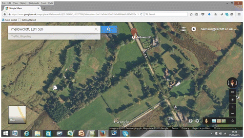
The value of the Google resources for planning enforcement is that ‘you can catch a lot of people out’ [10], indicating that these resources provide a genuinely supplementary instrument to other, more established means of identifying planning breaches. The reference to ‘catching people out’ includes the type of discovery referred to above for aerial photography, based on comparing historic images with recent ones to reveal that development has taken place (Figure ). Yet the images available through the Google technologies differ from traditional aerial photographic surveys in some important respects. The information captured in Google Street View, for example, is not clearly dated, and Dodge and Perkins (Citation2009) note how metadata such as date of image capture is either hidden or not available to end users. This, they argue, is problematic as the user interface ‘can encourage a belief in the veracity and accuracy of the data’ (p. 498; see also Elwood & Leszczynski, Citation2011). This can mean that users are unable to locate an image readily in time, although the interviews identified instances where this information had been secured by planning officers contacting Google for details. The images can therefore be used to simply distinguish between a development that is in place now and its former appearance, thereby helping to support the case for there being a breach of planning control. However, the images relayed in Google Earth and Google Street View may also be composites of images taken at different times (Elwood & Leszczynski, Citation2011). So, planning enforcement officers’ use of these technologies reflects the take up of Google technologies by regulators despite some concerns over accuracy and rigour of data (Phadke, Citation2010). To that extent, its use reflects and exacerbates some established concerns in interpretation and use of traditional aerial photography (Lai, Citation1998, p. 164).
The ‘virtual’ site visit: ‘I am looking at the property now!’
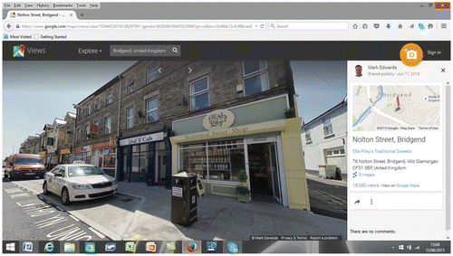
The most significant impact of Google Street View is to change practices of local planning authorities in ‘visiting’ a site. The advantage of Google Street View over Google Maps aerial imagery and conventional aerial photography for planning enforcement is its street-level view, and the vertical detailing of buildings and street scenes that this provides (Figure ). In effect, these technologies allow planning enforcement officers to virtually ‘go on-site’ while sitting in their offices. Several interviewees provided examples of this, with Google Street View being a source of immediate information to help with the targeting of further enquiries. In the first of the responses below, the officer speaks of the advantage of ‘seeing’ a site before a site visit is conducted, particularly the element of surprise in conducting the investigation, and anticipating difficulties in conducting the site visit itself:
[Google Street View] allows us to get an idea before we go to a site, what it looks like from the ground. So, first of all, if somebody's complained about car repairs we can get that up and look where the garage is, whether we'd be able to view it from the road, whether we wanted to book an appointment to start with … If we can make a useful first contact when they are not really aware of our investigation, the more pure the look at the potential breach. [16, emphasis added]
In this statement we see the tactical planning of a site visit, as well as reference to the value of seeing sites ‘from the ground’ rather than simply from an aerial viewpoint (see Vidler, Citation2011, p. 663). Another planning enforcement officer relayed the challenges of trying to imagine a site whilst discussing a potential breach with a complainant on the telephone, allowing them to see a property without physically being on site:
[Google] is not definitive in terms of timescales but it does give you an idea spatially of what you are looking at before you go on site. On a regular basis I'll get a call and someone will say ‘we've got a fence at the front’. ‘Is it between the boundaries? Is it in front of the house, or what? And what's the kind of detail?’ It's much easier if I can bring up Google Earth and say ‘well, I'm looking at the property now and I can see this and this’. [18, emphasis added]
In both of these cases of carrying out a ‘virtual site visit’—which interestingly refer to ‘looking at the property now’, when actually viewing historic images on screen—the technologies support preparation for a physical site visit in person. However, in another enforcement case, Google Street View displaced the requirement to visit a site altogether for some participants:
Yes we will [use Google Street View], just to help us understand their complaint. We can get that up and they can talk us through it. What I've also done as well is given a barrister a link to a particular site on Google Maps, because he didn't have time to look at the site in advance. Shocking really, isn't it!
Although based on a markedly different application of archaeological research in active war zones, Myers (Citation2010) notes how Google Earth can enable high quality records to be made ‘even when an in-person visit is impossible’ (p. 456). The traditional, in-person site visit is not yet at risk of replacement, yet in cases where it is impossible, difficult, unsafe or simply less convenient to conduct a site visit, then Google Earth and Google Street View can play a useful role for investigating breaches of planning control. The cost-effectiveness of Google Street View, in terms of saving both time and travel expenses, further supports its use.
Yet there are, inevitably, also limitations to the application of Google Maps and Street View in supporting planning enforcement. The first is the limited spatial coverage of the imagery. Rural areas in particular do not enjoy full coverage, resulting in ‘black holes’ and differential application of technologies between urban and rural contexts. This further enhances the portrayal of rural areas as spaces that are less capable of regulatory surveillance for planning enforcement, and echoes the historical difficulties of policing such areas (Dandekar, Citation1990, p. 114). It also reinforces the principle that surveillance strategies vary depending on the physical and geographical characteristics of an area (Ogborn, Citation1993, p. 508). Furthermore, even in areas with effective coverage, camera shots are restricted and do not always allow enforcement officers to explore the site. A further limitation with these technologies is one that characterises traditional aerial photography, and that is the fact that the images are ‘static’ and lifeless, despite the interface encouraging an artificial sense of interaction and ‘life’ (Dodge & Perkins, Citation2009, p. 498). So, these technologies exude an ‘allure of realism’, which in turn risks undermining the sensible and appropriate use of the visual imagery (Sheppard & Cizek, Citation2009, pp. 2106–2108). Finally, the technology is also open to the same difficulty of interpretation that is applicable to traditional aerial photography.
Some local planning authorities demonstrated efforts to deal with at least some of these limitations, including through commissioning further aerial and street capture imagery. One local authority reported having recently commenced a contract with a company that provided bespoke services similar to Google Street View:
It's a council-wide initiative. It's a vehicle that goes down every street in [our borough] and takes photographs from street level. It's a 360 degree camera. You can click on the arrows. You can look at the adjacent buildings either side. You can see the tops of buildings. You can zoom right in to see detail, window detailing, signage detailing [14]
These are bespoke services and not open access sources—and therefore resemble some of the privileged or restricted access that characterized traditional aerial photography—yet they highlight the use that is increasingly made of surveillance and image-capture technologies to enhance the capacity to detect, monitor and investigate breaches of planning control. The statement also highlights the quest for detail. So, while there has been apparently limited use made of CCTV by planning enforcement teams, there is a much more developed use of other forms of street-capture technologies.
Google Earth, ‘sweeping the neighbourhood’ and privacy: an international example
The emergence of new geo-visual technologies over the last decade has generated concern about individuals' privacy, particularly in the case of Google Street View (Myers, Citation2010, p. 462; Phadke, Citation2010, p. 278). The interviews nevertheless demonstrate that planning enforcement officers in England are routinely engaged in using Google Maps and Google Street View for the purposes of investigating cases and complaints of unauthorised development, in spite of occasional concerns over privacy. The use of these technologies has, however, been particularly controversial when applied in some other parts of the world. Knoedler (Citation2012) reported of one municipality in the USA that was ‘utilizing Google Earth to nab code violators’ (p. 421), focusing on the use of the technology to identify residential properties that had installed a private swimming pool contrary to the provisions of the planning code. The account identifies how some 250 residential properties were caught out through the systematic sweep of municipality of residential communities using Google Earth and checking these against planning files. The actions of the municipality caused significant controversy and ‘outraged civil libertarians who believe that the use of satellite imagery by the government is another step towards an Orwellian “Big Brother” society’ (Knoedler, Citation2012, p. 421). Interestingly, it was systematic trawl or sweep by the municipality using Google Earth that caused the most concern, with this considered far more objectionable than the occasional use of Google Earth to verify a complaint. The municipality yielded to public controversy and ceased use of Google Earth for identifying code violations, leaving it an open question as to the admissibility or appropriateness of such technologies within the constitutional framework in the USA. The application and acceptability of technologies such as Google Earth is clearly dependent on the cultural, social and legal context in any particular country. It is perhaps not surprising that the general public in the UK, which has so readily accepted the proliferation of CCTV in its towns and cities, has not generated the same level of controversy over the use of Google Earth and Google Street View by regulatory and public bodies.
Conclusion: Evaluating ‘The New Surveillance’ in Planning Enforcement
Aerial photography, CCTV and virtual globe applications of Google are three important components of planning enforcement's ‘surveillant assemblage’ (Haggerty & Ericson, Citation2000). Each of these reflects the ocular emphasis of many surveillance technologies, with a focus on the creation of visual imagery to complement other forms of data collection. Yet each of these technologies has different qualities, and these help to explain the variable use of these by local planning authorities. Aerial photography is a long-established technology in planning, having been used consistently for decades on the basis of its objective, distant and authoritarian view and the capacity to identify physical structures within defined plots of land. The systematic conduct of aerial surveys remains important, yet is being gradually eroded as either opportunities arise through ‘function creep’ from other services such as police surveillance, or as more emphasis is placed on bespoke flyovers as the technology becomes more accessible and the costs become more affordable. The opportunities provided for planning enforcement by CCTV are far more modest than the surveillance studies literature might suggest are possible. CCTV does provide the opportunity for moving imagery, which has value in investigating uses and activities over physical structures, yet professional preferences for embodied surveillance mean that CCTV is used in planning enforcement in only limited circumstances. The research also echoes conclusions of others that the capacity and utility of CCTV is often overstated, including in the surveillance studies literature. Finally, the use of virtual globe technologies and other high-resolution satellite imagery, alongside street-level image capture such as Google Streetview, are used frequently in planning enforcement. Their use is explained by various factors, such as ease of use, seductively ‘real’ imagery, and the open-access and free-to-use qualities of the services. The ability to access a street-level view of urban environments immediately from the comfort of an office desk appears to be particularly valuable for planning enforcement officers. This allows them to be ‘on site’ quickly, talk through the site with someone on the telephone, and plan their physical site visit at a later date.
Several thematic conclusions can also be drawn from this ‘grounded investigation’ of surveillance practices (Haggerty & Ericson, Citation2006, p. 3). The first of these relates to the concept of ‘function creep’, in which surveillance technologies spill over into other domains. The use of police helicopter services to conduct ‘recces’ for planning enforcement teams—a practice that occurs informally and as a requested favour for ex-police colleagues, or simply as support from one regulatory function for another—is a good example of function creep. Similarly, the launch of Google Street View has generated a wide range of different uses, including planning enforcement officers' ‘virtual site visits’, that are effectively by-products of technologies generated for other uses. The second theme relates to so-called ‘democratisation’ of surveillance technologies in which the wider population can access surveillance tools and information (Perkins & Dodge, Citation2009; Phadke, Citation2010; Timan & Oudshoorn, Citation2012). The research has identified how the once privileged ‘view from above’ is being displaced by open-access technologies. Google Earth and the satellite view in Google Maps enable people to access high-resolution satellite imagery with ease and for free. The local authority no longer has near-exclusive access to this view of the world, rectifying any power imbalance that may have existed historically. Interestingly, interviewees cited the open access and free-for-all qualities of these technologies as reasons why they themselves were very comfortable in using them in their investigations, suggesting a degree of comfort with this flattening of surveillance hierarchies. The third theme relates to the effects of surveillance technologies on regulators' relationships to physical sites. It is acknowledged that the use of high-resolution satellite imagery ‘is radically shaping the ways different groups comprehend space and place’ (Dodge & Perkins, Citation2009, p. 497). Similarly, Myers (Citation2010, p. 456) argued that Google Earth has the capacity to shift the relationships between professionals, the data that they use in their practice and the subjects and objects of their practice. He argues that these technologies can have a ‘distancing’ effect, in which people become detached from the human side of their former practices. The emergence of ‘the virtual site visit’ is of particular interest here, enabling planners to tactically plan their investigative site visit prior to going out on site, to ‘accompany’ a complainant as they discuss on the telephone their concerns about a suspected unauthorised development, or even in some cases to do away with the requirement for a site visit in person. The final theme relates to the interface between embodied surveillance and technologically mediated surveillance, and it is here that any distancing effects of technologies will be moderated in planning enforcement. The surveillance technologies relayed in this article play a complementary and perhaps limited role to more established practices of direct surveillance of and by the embodied person—even where technologies could displace aspects of embodied surveillance in planning enforcement, there is a preference for personally witnessing activities. So, overall, the case of planning enforcement points to a variable series of conclusions on the potential of surveillance technologies to transform the surveillance practices of professionals.
Disclosure statement
No potential conflict of interest was reported by the author.
Notes
1. Extracts from interviews in this article are identified by reference to an interviewee number.
2. In England, the planning system establishes periods after which unauthorised development becomes ‘immune’ from enforcement action. For physical operations, this is a period of 4 years. For most material changes of use it is a longer period of 10 years. The different periods for physical operations and material change of use are explained by the greater difficulty in detecting and establishing that a material change of use has occurred.
3. Oblique photographs are those taken at an angle, rather than directly from above as in the case of typical aerial surveys. They would provide planning enforcement officers with a ‘side’ view of a building, for example, rather than simply a vertical view.
4. Recce is a term abbreviated from reconnaissance and means a visit or inspection designed to gather information.
Related Research Data
References
- Andrejevic, M. (2005) The work of watching one another: Lateral surveillance, risk and governance, Surveillance Studies, 2(4), pp. 479–497.
- Ball, K., & Haggerty, K. D. (2005) Editorial: Doing surveillance studies, Surveillance and Society, 3(2/3), pp. 129–138.
- Burby, R. J., May, P. J., & Paterson, R. C. (1998) Improving compliance with regulations: Choices and outcomes for local government, Journal of the American Planning Association, 64(3), pp. 324–334. doi:10.1080/01944369808975989.
- Carnwath, R. (1989) Enforcing Planning Control (London: HMSO)
- Dandekar, C. (1990) Surveillance, Power and Modernity. Bureaucracy and Discipline from 1700 to the Present Day (Cambridge: Polity Press)
- Dodge, M., & Perkins, C. (2009) The ‘view from nowhere’? Spatial politics and cultural significance of high-resolution satellite imagery, Geoforum, 40(4), pp. 497–501. doi:10.1016/j.geoforum.2009.04.011.
- Elwood, S., & Leszczynski, A. (2011) Privacy, reconsidered: New representations, data practices, and the geoweb, Geoforum, 42(1), pp. 6–15. doi:10.1016/j.geoforum.2010.08.003.
- Germain, S., Dumoulin, L., & Douillet, A. (2013) A Prosperous ‘Business’: The success of CCTV through the eyes of international literature, Surveillance and Society, 11(1–2), pp. 134–147.
- Graham, S., & Wood, S. (2003) Digitizing surveillance: Categorization, space, inequality, Critical Social Policy, 23(2), pp. 227–248. doi:10.1177/0261018303023002006.
- Haggerty, K. D., & Ericson, R. V. (2000) The surveillant assemblage, British Journal of Sociology, 51(4), pp. 605–622. doi:10.1080/00071310020015280.
- Haggerty, K. D., & Ericson, R. V. (2006) The new politics of surveillance and visibility, in: K. D. Haggerty & R. V. Ericson (Eds) The new politics of surveillance and visibility, pp. 3–25 (London: University of Toronto Press)
- Harris, N. (2011) Discipline, surveillance, control: A Foucaultian perspective on the enforcement of planning regulations, Planning Theory and Practice, 12(1), pp. 57–76. doi:10.1080/14649357.2011.545631.
- Harris, N. (2013) Surveillance, social control and planning: Citizen-engagement in the detection and investigation of breaches of planning regulations, Town Planning Review, 84(2), pp. 171–196. doi:10.3828/tpr.2013.11.
- Kearon, T. (2013) Surveillance technologies and the crises of confidence in regulatory agencies, Criminology and Criminal Justice, 13(4), pp. 415–430. doi:10.1177/1748895812454747.
- Kingsbury, P., & Jones, J. P. (2009) Walter Benjamin's Dionysian adventures on Google Earth, Geoforum, 40(4), pp. 502–513. doi:10.1016/j.geoforum.2008.10.002.
- Knoedler, E. (2012) Satellites and municipalities: One town's use of Google Earth for residential surveillance, Touro Law Review, 28, pp. 421.
- Koskela, H. (2000) ‘The gaze without eyes’: Video-surveillance and the changing nature of urban space, Progress in Human Geography, 24(2), pp. 243–265. doi:10.1191/030913200668791096.
- Koskela, H. (2003) ‘Cam Era’—The contemporary urban panopticon, Surveillance and Society, 1(3), pp. 291–313.
- Lai, L. W. C. (1998) The use of aerial photographs in planning enforcement against unauthorised development, in: L. W. C. Lai (ed.) Zoning and Property Rights: A Hong Kong Case Study, 2nd ed., pp. 157–173 (Hong Kong: Hong Kong University Press)
- Lai, L. W. C., Yung, P., Li, R. Y. M., & Ho, D. C. W. (2007). The private supply of and demand for planning: compliance with planning conditions in the absence of direct statutory enforcement measures, Planning Practice and Research, 22(4), pp. 535–557.
- Lianos, M. (2003) Social control after Foucault, Surveillance and Society, 1(3), pp. 412–430.
- Lo, C. P. (1973) The use of orthophotographs in urban planning, Town Planning Review, 44(1), pp. 71–87. doi:10.3828/tpr.44.1.45621534p7728055.
- Lyon, D. (2001) Surveillance Society. Monitoring Everyday Life (Buckingham: Open University Press)
- Lyon, D. (2007) Surveillance Studies. An Overview (Cambridge: Polity Press)
- Marx, G. T. (1988) Undercover. Police Surveillance in America (Berkeley, CA: University of California Press)
- McKay, S. (2007) Contravention and conformity in EIA: An investigation into regulatory compliance in Northern Ireland, European Planning Studies, 15(1), pp. 87–105. doi:10.1080/09654310601016663.
- McKay, S., Berry, J., & McGreal, S. (2003) Planning enforcement: Lessons for practice and procedure, Planning Theory and Practice, 4(3), pp. 325–344. doi:10.1080/1464935032000118670.
- McKay, S., & Ellis, G. (2005) Reparation or retribution: An investigation into regulatory compliance in planning, Environment and Planning A, 37(7), pp. 1249–1262. doi:10.1068/a36288.
- Muir, L. (2012) Control space? Cinematic representations of surveillance space between discipline and control, Surveillance and Society, 9(3), pp. 263–279.
- Myers, A. (2010) Camp Delta, Google Earth and the ethics of remote sensing in archaeology, World Archaeology, 42(3), pp. 455–467. doi:10.1080/00438243.2010.498640.
- Oc, T., & Tiesdell, S. (2000) Urban design approaches to safer city centres: The fortress, the panoptic, the regulatory and the animated, in: J. R. Gold & G. Revill (Eds) Landscapes of Defence, pp. 188–208 (Harlow: Pearson)
- Ogborn, M. (1993) Ordering the city: Surveillance, public space and the reform of urban policing in England 1835–56, Political Geography, 12(6), pp. 505–521. doi:10.1016/0962-6298(93)90002-O.
- Perkins, C., & Dodge, M. (2009) Satellite imagery and the spectacle of secret spaces, Geoforum, 40(4), pp. 546–560. doi:10.1016/j.geoforum.2009.04.012.
- Phadke, R. (2010) Defending place in the Google Earth age, Ethics, Policy and Environment, 13(3), pp. 267–281. doi:10.1080/1366879X.2010.516495.
- Prior, A. (2000) Problems in the theory and practice of planning enforcement, Planning Theory and Practice, 1(1), pp. 53–69. doi:10.1080/14649350050135194.
- Purdue, M. (2008) Reform of the enforcement of planning control: A forgotten cause? Journal of Planning and Environment Law, 4, pp. 434–449.
- Rao, M., & Sridhara Murthi, K. R. (2006) Keeping up with remote sensing and GI advances—Policy and legal perspectives, Space Policy, 22(4), pp. 262–273. doi:10.1016/j.spacepol.2006.09.001.
- Rapoport, M. (2012) The home under surveillance: A tripartite assemblage, Surveillance and Society, 10(3–4), pp. 320–333.
- Reeves, J. (2012) If you see something, say something: Lateral surveillance and the uses of responsibility, Surveillance and Society, 10(3–4), pp. 235–248.
- Rundle, A. G., Bader, M. D. M., Richards, C. A., Neckerman, K. M., & Teitler, J. O. (2011) Using Google street view to audit neighborhood environments, American Journal of Preventative Medicine, 40(1), pp. 94–100. doi:10.1016/j.amepre.2010.09.034.
- Schroth, O., Pond, E., Campbell, C., Cizek, P., Bohus, S., & Sheppard, S. (2011) Tool or toy? Virtual globes in landscape planning, Future Internet, 3(4), pp. 204–227. doi:10.3390/fi3040204.
- Sheppard, S., & Cizek, P. (2009) The ethics of Google Earth: Crossing thresholds from spatial data to landscape visualisation, Journal of Environmental Management, 90(6), pp. 2102–2117. doi:10.1016/j.jenvman.2007.09.012.
- Simon, B. (2005) The return of Panopticism: Supervision, subjection and the new surveillance, Surveillance and Society, 3(1), pp. 1–20.
- Tiesdell, S., & Oc, T. (1998) Beyond ‘fortress’ and ‘panoptic’ cities—Towards a safer urban public realm, Environment and Planning B: Planning and Design, 25(5), pp. 639–655. doi:10.1068/b250639.
- Timan, T., & Oudshoorn, N. (2012) Mobile cameras as new technologies of surveillance? How citizens experience the use of mobile cameras in public nightscapes, Surveillance and Society, 10(2), pp. 167–181.
- Turland, M. J. (1990) Planning permission conditions—Are they a waste of resource? Journal of Planning and Environment Law, 3, pp. 184–185.
- Vidler, A. (2011) Photourbanism: Planning the city from above and below, in: G. Bridge & S. Watson (Eds) The New Blackwell Companion to the City, pp. 656–666 (Oxford: Wiley-Blackwell)
- Wakefield, A. (2005) The public surveillance functions of private security, Surveillance and Society, 2(4), pp. 529–545.
- Walton, S. (2010) The politics of surveillance: Big brother on prozac, Surveillance and Society, 8(1), pp. 61–84.
- Webster, W. (2009) CCTV policy in the UK: reconsidering the evidence base, Surveillance and Society, 6(1), pp. 10–22.
- Wood, D. (2005) Editorial. People watching people, Surveillance and Society, 2(4), pp. 474–478.
- Wood, D. M. (2007) Beyond the panopticon? Foucault and surveillance studies, in: J. W. Crampton & S. Elden (Eds) Space, Knowledge and Power. Foucault and Geography, pp. 245–263 (Aldershot: Asghate)
- Yiftachel, O. (1998) Planning and social control: Exploring the dark side, Journal of Planning Literature, 12(4), pp. 395–406. doi:10.1177/088541229801200401.
- Zurawski, N. (2005) “I know where you live!”—Aspects of watching, surveillance and social control in a conflict zone (Northern Ireland), Surveillance and Society, 2(4), pp. 498–512.