
ABSTRACT
The North Sea is undergoing severe ecological degradation. Can this condition be used as leverage for a change in societal attitudes, which are subsequently reflected in planning practices? Currently, both avenues are progressing with few effective feedback loops. This question is examined through imaginative proposals made by students at Bergen School of architecture, who address the North Sea as a holistic seascape composed of human-made and natural phenomena and aim to provide strategies for ecological recovery while reinstating the commons.
Introduction
The North Sea Is Virtually Dead
At the final exhibition of 15 architectural projects on the North Sea, the guest critic’s statement landed heavily in the room sending a wave of ensuing silence and inertia among teachers, students, an oceanographer, and further guest.Footnote1 Acutely aware of the levels of sound, light, plastic and heavy metal pollution in the North Sea, as well as ongoing processes of eutrophication and oil seepage, the student projects represented both utopic and dystopic visions for a differentiated North Sea Eco-commons.
Sea space gathers diverse stakeholders who operate according to different value systems, knowledge bases and vested interests; a characteristic familiar to marine spatial planners. The debate in the exhibition room also involves different protagonists; the guest critic researches ocean transformations using open-source data to connect disparate sources and to demonstrate the magnitude of human impact on marine life. Visually synthesising diverse realms of knowledge, the work seeks to reach a wider audience through linking scientists, artists, policy makers, and conservationists (Palmesino & Rönnskog, Citation2021). Despite the immediacy of oceanic tipping points, disturbed thermohaline circulation and the extent of sea-level rise predicted for Bergen’s historical central-city harbour right outside the building, with which he works on a daily basis, the oceanographer still sees the projects as inspiring hope–perhaps the single-most important requirement for future public action in maritime affairs. The students had carried out research and spatial experimentation in a physical domain they previously had little knowledge of. Their aim was to activate their new understanding in a speculative way – envisioning spaces, conditions and more-than-human protagonists they had discovered – beyond science and into the imagination. Their projects were pro-active, telling new stories of recovery, inciting reactions and commanding attention. The students represent a new sector of the public – ‘non-scientific actors’ (Smith & Brennan, Citation2012) – who are literate in ocean space and are tentatively acting on behalf of the sea itself. A precedent for this approach was established in the context of Gugger’s Barents Sea study, where one proposal aimed to reverse the current maritime management system; ‘instead of resources being at the exploitative centre of economic processes … economies, governments and infrastructure now serve the needs of, and act on behalf of, the resource itself’ (Gugger et al., Citation2012). How would the sea itself demand to be planned?
This paper departs from the proposition that the ecological condition of the North Sea, including the effects of climate change, will be the lever that shifts current practices, also affecting planning. Through presenting imaginative student proposals that include these considerations, the aim is to demonstrate how marine space can be visualised beyond GIS mapping and container spaces, and to stimulate the current debates on MSP. The experiment indicates a set of results that emerge from a group of ‘stakeholders’, who also have a vested interest in the space of the sea, but who have not, as yet, been invited to the decision-making table. With the legislative adoption of MSP this year by the EU, its closer critical evaluation coupled with discussions around a parallel series of alternative planning and design models, is timely. Together with the major maritime industries, governments have nominated MSP as the instrument serving societal needs for more effective and coordinated organization of sea spaces that are increasingly subsumed to a multitude of demands. Within this context, could MSP itself affect a shift in practices?
Other key authors have contributed to establishing an overview of the evolution of MSP (Jay, Citation2010), (Flannery et al., Citation2020). Since its inception in the early 2000’s, MSP has advanced rapidly into its own sector of education, discourse and policy at the same time as the ecological condition of Europeans seas has rapidly declined (European Commission, Citation2014). The discourse includes multiple reflections on these very planning practices as they unfold: their shortcomings, potentials and challenges (Flannery et al. Citation2016). MSP’s mandate is to provide spatial opportunities for both Blue Growth and the maintenance of healthy marine ecologies. Our own analysis shows that these tasks are clearly conflicting in the North Sea (see Part two). The North Sea, then, is a potential case where a different approach could be of benefit.
As the ecological crisis moves into public consciousness, could MSP practices manifest a philosophical shift from what Bruno Latour describes as ‘Matters of Fact’ to ‘Matters of concern’ (Latour, Citation2008)? According to Latour, this would require understanding that around facts – which have remained a highly durable, resilient, but partial, distorted and impoverished format throughout history – exist a whole ‘scenography’ of social experience that should be acknowledged (Latour, Citation2004). In addition to scientific knowledge, matters of concern must be important and ‘liked’ for a dedicated part of the population. They must endure and be made up of the heterogeneous ‘assemblies’ necessary for objects and facts to come into being in the first place, rather than being isolated from their socio-cultural contexts. Latour refers to Donna Haraway’s call to collectively protect and care for matters of concern, to ‘stay with the trouble’ (Haraway, Citation2016), rather than to prematurely end a common debate; ‘an appeal to undisputable facts is followed by pure violence’ (Latour, Citation2008). Design Earth are a design practice who engage with critical, complex, large-scale geographic issues. In their work on the aesthetics of the Earth as a Matter of Concern, they argue that the focus on matters of fact has led to the current ecological crisis (Ghosn & Jazairy, Citation2018).
The sea – a material, spatial, ecological and recreational resource – is undoubtedly the site of one of this century’s greatest planning challenges (Couling, Citation2016). Despite the knowledge gained, the vast amounts of available data, and the wealth procured from maritime resources, particularly over the last seventy post-war years in the North Sea, Northern European society has not progressed in developing a holistic understanding of the sea and our interactions with and through it. The condition of wider societal misconceptions and understandings of sea space is directly reflected in planning practices.
If ecological conditions are moving into the forefront of societal concern, this paper asks if then MSP – currently our primary means of articulating relationships in maritime space – could not evolve into a different role? The first part of this paper sketches out three contradictions facing planning in the North Sea; Invisibility, Contingency and Enclosure. Invisibility relates to how Northern European society has distanced itself from the sea, rendering it largely invisible and how the apparent invisibility of the levels of exploitation, prevent these ‘facts’ becoming a matter of public concern. Public understanding of what is taking place in the North Sea is limited and spatial representations of the extent of activities are only beginning to become part of a wider societal debate (Couling, Citation2020). Contingency relates to the uncertain effects of planning decisions throughout the ecosystem. The quantum scale shift of the offshore wind industry for example, poses environmental questions beyond the current capacity of prediction models. But planning processes must find space for these developments. Enclosure relates to the artificial borders of the Exclusive Economic Zones, which do not correspond to ecological systems and prevent the North Sea from being visualised and understood as an integrated, coherent spatial and ecological unit.
The second part of this paper steps back from conventional planning and addresses the questioning of societal relations to the sea in ways that correspond to planetary challenges. Materials and methods are chosen from exploratory design within an educational framework – a context within which students were free to develop more ‘radical’ visions, within which critical approaches to invisibility, contingency and enclosure are integrated into the project designs.
Anchored in the discipline of architecture, this chapter aims to link important sources in philosophy, cultural studies and urban theory, to selected MSP literature in Part One, illuminating contradictions which speculative design then reacts to in part Two. As suggested by Flannery and Ellis, such work can serve to provide a different perspective and make a contribution to the reflection on a more ‘radical MSP’ (Flannery et al. Citation2016), which could potentially place ecological concerns at the forefront of design.
Part One
Invisible Distance
Sea Blindness is commonly understood as the ignorance of the sea’s vital role in our industrialised lives. This condition is echoed in the physical and psychological breach between land and sea within European society, which over the last post-war years, has been steadily widening as fishing fleets, port work involving manual labour and passenger transport have diminished. Miller pinpoints 1956 as the year of two critical changes; the first PanAm trans-Antlantic jet service was introduced on the same day as a converted tanker carried 58 truck trailers from Newark to Houston, heralding in the age of containerisation (Miller, Citation2012). These parallel developments resulted in the steady evacuation of the social sea – a space that society at large experienced and was engaged with. Photographer Alan Sekula calls the sea the ‘forgotten space’; ‘100,000 invisible ships, 1.5 million invisible seafarers binding the world together through trade’ (The Forgotten Space, Citation2010). He noted the slow disappearance of the sea between 1960 and 1985, through the parallel disappearance of shipping news from the New York Times (Sekula, Citation2002).
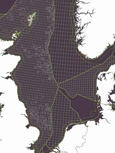
In the case of the North Sea, this period marked its reorganisation and transformation into a vast site of oil and gas production. The practices of maritime resource extraction and production long predate MSP. But production and planning are inextricably intertwined- the spatial expansion of the former leading to the implementation of the latter. The highly lucrative North Sea fishing industry had been overfishing for hundreds of years before the discovery of oil and gas in the 1960’s. It was the eagerness of littoral nations to accommodate the petroleum industry that led to the rapid resolution of offshore borders in the North Sea directly after the formulation of the Convention on the Continental Shelf (1964) – the UK and Norway setting their median line only months afterwards (Chapman, Citation1976). Particularly in the UK, this enabled the establishment of a legal basis for rapid exploration- the petroleum grid – across the major part of the North Sea (Couling & Hein, Citation2018). () As decommissioning now unfolds, offshore wind is rapidly stepping in to take its place (Couling, Citation2022), resulting in a seascape that is ‘operationalized’ in a way that echoes comparable landscapes of production (Katsikis, Citation2014). The establishment of the Exclusive Economic Zones unleashed planning practices to manage this newly defined space. Hence, as a result of these processes, the sea has been reformatted into both a comprehensive production site, and a space to be planned (Gee & Siedschlag, Citation2019). MSP has been commissioned to step into this void.
Figure 1. North Sea petroleum grid (author) (previously published).
The paradox of increased activity in the North Sea, in particular activities such as oil and gas exploration and wind-park development that require securing static production sites for initial periods of 25 years, and for which marine spatial planning has been adopted to manage and spatially organise, lies in the extent to which these activities are masked, fragmented and difficult to decipher for outsiders. Three factors contributing to this phenomenon have been identified; how scale and distances at sea conceal, how daily offshore social interaction has been radically reduced, and how the dominant technical, infrastructural character of North Sea installations prevents a full understanding of their spatial impact (Couling, Citation2018). Installations are isolated and dispersed, and the lineal systems connecting them are either sub-sea and therefore invisible, or moving periodically across the surface. In particular, the spatial impact of energy logistics is largely invisible; while energy logistics has not yet been spatially conceptualised, it has developed and expanded offshore in collaboration with state authorities ‘in an overwhelmingly linear, two-dimensional way’, which overlooks critical socio-cultural dimensions (Couling & Hein, Citation2018, Citation2020).
Sea Blindness has also led to shortcomings in marine spatial planning. Peel & Lloyd argued that the ‘marine problem’ is in its infancy, and is yet to be ‘successfully socially reconstructed’ (Peel & Lloyd, Citation2004). In his careful investigation into the specific nature and emergence of marine spatial planning, Jay acknowledges that precisely the distance between the realms of maritime activity proper, and the social and political centres, could tend to result in a technical elite of decision-makers representing a relatively small group of stakeholders (Jay, Citation2010). The industrialisation of the North Sea has led to the consolidation of an invisible space of production, to be organised through planning, but from which the public is fully distanced.
Contingencies
The marine environment is by definition contingent, its planning permeated with uncertainties. The ‘Blue growth’ promoted by the European Commission aims to increase economic growth and employment in the maritime sectors through a range of initiatives, including removing administrative barriers, supporting research and innovation and encouraging investment in the ‘blue economy’ (European Commission, Citation2014). Blue energy, aquaculture, coastal and maritime tourism, blue biotechnology and sea-bed mining are sectors identified as having particularly high growth potential.
The deployment of scientific knowledge as a basis for advancement in these industries reflects our long-standing trust in techno-scientific solutions in the maritime context. Likewise, decision-making in Marine Spatial Planning, and in ecosystem-based management in particular, has been based on the ‘primacy of scientific knowledge’ (Jay, Citation2010). A further paradox of our management of the sea is the wealth of marine science on the one hand, and the lack of knowledge on precisely the measures we are planning for, on the other. Rapidly expanding North Sea wind energy installations are one example. Smaller, singular offshore wind parks do not raise the same environmental questions as those raised by up scaling across large areas. In their powerful visualisation presented at the Rotterdam Biennale 2016, H + S + N landscape architects demonstrated what the North Sea would look like, fitted out with 25,000 turbines which could cover 90% of Northern European electricity requirements by 2050 (Sijmons & Hajer, Citation2020). But understanding the cumulative effects of wind energy installations, developing reliable methods to calculate these effects, as well as practices to alleviate the problems and smoothen planning processes, are all steeped in uncertainty (Willsteed et al., Citation2018).
‘The lack of knowledge about cumulative impact is in stark contrast to the regulatory requirements at both UK and EU levels to take it into account.’ (European Committee (UK), Citation2015).
UK fishermen have noticed a change in wind patterns due to the increase in wind parks, which they sense can subsequently have an effect on currents and water flow. In the North Sea, research on the effect of wind farms on water-mixing and stratification is being carried out (Carpenter et al., Citation2016), while large-scale turbine groups alter the atmospheric ‘boundary layer’, indicated by slight surface temperature increases on land and decreases offshore. Since the extraction of renewable energy means to change natural energy fluxes, consequences are unavoidable. Oceanographers explain that it is not known what happens when energy is taken out of the sea itself. Current studies on the environmental impact of wave and tidal current energy installations focus on marine life rather than on the overall loss of energy from the sea (Uihlein & Magagna, Citation2016). In theory such an extraction on a large enough scale could ultimately affect oceanic circulation or tides.
The seas, and also the atmosphere above, present us with contingent, non-linear quantitative relations that are difficult to model. Scientific evidence relating to the disruptive effects of construction and dismantling of wind parks, such as noise pollution and habitat displacement, have generally been well documented (Draget, Citation2014). Recycling of obsolete turbine blades is still unresolved, and as pointed out by Jørgensen, considering the large-scale plans for wind-energy and oil and gas decommissioning in the North Sea, this basin would be more accurately understood as a site of continuous construction and dismantling, than a wilderness where ‘natural’ processes continue undisturbed (Jørgensen, Citation2020). The latter is still the predominant narrative concerning sea spaces in the minds of the general public, while the ‘creative destruction’ of capitalism is physically shaping and reshaping the geographical landscape (Harvey, Citation1989).
Blue growth in the expanding aquaculture industry is also hampered by difficulties. While export earnings through farmed salmon have risen steeply in Norway since the modest birth of the industry in the 1960’s, amounting to 68 billion NOK in 2020, corresponding to around 6.6 billion euros (Statistics Norway, Citation2020), production is plagued by high levels of sea lice, which thrive in the confinement of aquaculture pens and cause significant damage (FAO, Citation2020). Wild salmon frequently swim past salmon farms to reach fresh water, thereby also becoming at risk of infection. These two areas of expected Blue Growth – blue energy and aquaculture – while exerting large-scale changes on the seascape, and requiring careful planning consideration, present unexpected challenges that stand to impede their very growth expectations. Industry predictions are hopeful and geared towards technological positivism, since they fulfil the vital societal needs of food and renewable energy production. Hence, ‘the dominant logic remains one of scientific rationalism’ (Jay, Citation2010). Environmental impact assessments frequently conclude that habitat disturbance is minimal across the scale of the sea, however particularly in the North Sea, the areas of undisturbed sea-space available for habitat displacement have been starkly reduced. Fishers explain how the exclusion of fishing vessels from oil, gas and increasing wind farm areas, results in added pressure on existing fishing grounds and how wind farms have an impact on every aspect of the ecosystem (Oliver, Citation2019).
Some MSP projects have already been experimenting with different planning processes adapted to complex marine contexts with a diverse group of stakeholders. In their pilot project on the Tuscan archipelago, planners adopted research by design, rather than traditional planning methods, to approach land-sea interactions – a specific area that is as yet less defined in terms of legislation, limits of analysis and planning precedents (Bassan et al., Citation2020). The design process is malleable, responsive and open-ended. It is a cognitive process within which the definition of the ‘problem’ evolves concurrently to a possible number of solutions. Research on the design process confirms that problems and solutions are kept fluid until they are identified jointly through the articulation of a concept- a creative leap, or a bridge between the two (Cross, Citation2006). Planning on the other hand, is more frequently charged with progression towards a pre-determined goal, and in the case of Marine Spatial Planning, with a predominantly economic agenda.
Enclosure
To enhance cooperation, coordination and communication between different actors, one of the six objectives recommended by the IOC for the Decade of Ocean Science, is an accessible and transparent ocean where access to data and information is freely available (UNESCO and IOC, Citation2019). Our analysis of different governing bodies and organisations around the North Sea revealed a complex patchwork of partially overlaying responsibilities and jurisdictions. The current arrangement of combined MSP’s is also fragmented. The North Sea as a geographic place is not yet transparent or accessible, a fact reflected directly in the data. Achieving a central source of available marine data in the North Sea has been recognized as still being a major challenge, although initiatives such as the European Marine Observatory Data network (EMODnet) contribute to solving this problem. (European Committee (UK), Citation2015).
Instead, the sea itself as a unified geo-political unit does not exist, rather is divided by national EEZ’s. History is replete with examples of lands that have been divided and separated by different political regimes- the division of Poland between Russia, Prussia and Austria at the end of the eighteenth century being a prime example (Leisering, Citation2000). The division of the North Sea places the legislative apparatus in national hands for ‘practical’ purposes. While collaboration is recognized as imperative, not in the least in the face of the degraded environmental condition of the North Sea, and transboundary pilot projects have been carried out, for example for the Dogger Bank, its practical achievement is less obvious (van Tatenhove, Citation2017). The management approach to the North Sea has been fragmented from the outset, exacerbating the difficulty of overcoming legislative borders through regional spatial imaginaries (Walsh, Citation2020).
Contradictions between the global, interactive dimension of seas, and the tightening territorial corset have been discussed in different ways by many authors; in terms of ‘smooth and striated space’ (Jay, Citation2020), fluidity and fixity (Bode, Citation2015) and the transboundary nature of environmental problems (van Tatenhove, Citation2016). Traffic is regulated by the IMO- a global authority, and the European Union has played a major role on providing a unifying perspective in the North Sea, until the recent Brexit negotiations. Documents such as The North Sea 2050 Spatial Agenda (The Netherlands) make reference to the wider spatial context of the North Sea in their maps and create awareness of the importance of cross-border collaboration (Walsh, Citation2020). Theutenberg argues that the first rules of modern international law were perhaps the rules governing the use of the sea (Theutenberg, Citation1984). Although the oldest recognised commons were the high seas, the spatial reduction of the high seas through EEZ’s, and in the case of the North Sea, their complete elimination, means that the discussion on the governance of the global maritime commons has shifted to Areas Beyond National Jurisdiction. Hence, while the seas are global and interconnected, their jurisdiction is localized and there is an absence of a superordinate authority to administer the associated responsibilities. (Vogler, Citation2000).
In his discussion on the limits to state territoriality, Andreas Faludi draws on the sea itself as a metaphor. Instead of states spatially conceived as being neatly ‘shoulder to shoulder’, he proposes thinking about states as Islands in a sea of relations or even better, ice floats, since they too change shape, grow or diminish; ‘There is nothing eternal about them. They are historic constructs’ (Faludi, Citation2018).
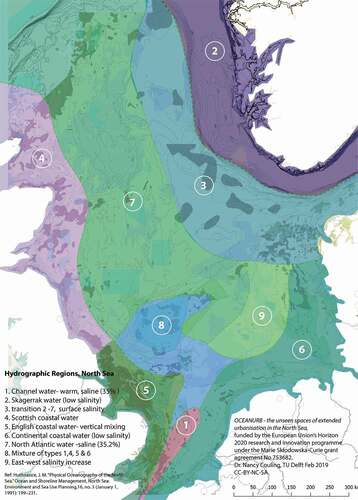
Now that European Seas are firmly divided into extended parcels of state space, which alternative forms of spatial organization can be imagined? In oceanographic terms, the North Sea is divided into nine hydrographic regions, determined by currents, bathymetry, temperature and salinity. (). The application of ecological ‘boundaries’ to conceptualise territorial units is being adopted through the use of watersheds in water management (Barham, Citation2001), and is advocated by the Bioregionalsim school of thought led by Alberto Magnaghi (Magnaghi, Citation2003).
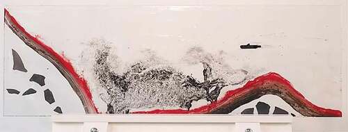
Figure 2. An imaginary section of the ocean- chaos, alien (David Aadland, BAS 2019).
How could the space of the North Sea be conceptualised spatially utilising ecosystem-driven differentiation, while taking invisibles into account, revealing distant, unseen activities and priorities, making them matters of concern, and bringing contingencies and unknowns into the process of marine design?
Part Two
Designing in the Decade of Ocean Science
The Decade of Ocean Science for Sustainable Development 2021–2030 has been established by the UN in the acknowledgement – due to scientific evidence – that ocean health is immersed in a cycle of decline and that increased environmental stress factors are predicted for the future. The UN’s Intergovernmental Oceanographic Commission (IOC) is responsible for designing the Decade and has recommended six objectives; a clean ocean, a healthy and resilient ocean, a predictable ocean, a safe ocean, a sustainably harvested ocean, and a transparent ocean. It also aims to develop innovative ways to communicate ocean science, including ocean literacy, to encourage more inclusive and participative approaches in designing and executing the science, and to reinforce dialogues including multidisciplinary approaches, integrating natural, social and engineering sciences and valuing indigenous knowledge (UNESCO and IOC, Citation2019).
This latter series of objectives is of particular interest to Master design courses currently being carried out at Bergen School of Architecture. Becoming more literate in ocean space is one way of overcoming Sea Blindness, and a way to encourage a sense of public stewardship towards the sea, which as I argue in part one, has been diminished through the increasing public distance to the sea, and the ‘invisibility’ of activities. The IOC manual defines ocean literacy as the ‘individual and collective understanding of the importance of the ocean to humankind’, whereby the regional differences in defining ocean literacy are stressed (Santoro et al., Citation2017). Knowledge is transformed and enriched when different sources are brought into dialogue with the Ocean.
In addition to carrying the grave environmental concerns of their generation, current architecture students are skilled in spatial representation and the ability to create imaginative proposals. They are trained to activate knowledge, to mould material and space into something new, and to find engaging ways to communicate ideas. To understand the challenges of the North Sea, and to be able to react through design in a speculative way, is empowering. A further important skill is one of synthesis. Ocean science is characterised by a ‘data tsumani’ – large amounts of specialised data, but a lack of methods to synchronise, share and assess it (Brett et al., Citation2020). The ability to summarise and communicate the essentials in complex oceanic relations to a broader audience is vital to the improvement of ocean literacy. Hence the work answers the decade’s call for more multi-disciplinary approaches integrating other forms of ‘science’ and knowledge. The projects discussed below have each evolved out of a specific position in relation to the objectives articulated for the Decade of Ocean Science. They are the results of a Master-level design studio conceived and taught by the (architect) author, in collaboration with an artist teacher, at Bergen School of Architecture, Norway. The course builds on the author’s previous North Sea spatial research, using this and other sources as a basis for creative design.Footnote2
Explorations in Ocean Space
If we were to think of the Ocean as a geographic place with spatial characteristics, histories, and desires inscribed into its waters, how could we begin to represent it? How could we position ourselves to interact with and to develop holistic strategies for such a place?
An analysis of the North Sea – one of the world’s most industrialised seas (European Committee (UK), Citation2015) – swiftly revealed burgeoning ecological problems; the space has become saturated with both the debris of an urbanised planet and competing uses.
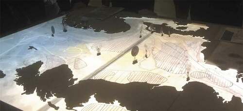
In order to structurally include plural forms of understanding, the programme explored intuitive, artistic, technological and scientific directions, including the distinct methods particular to each. Intuitive drawings and conceptual models were important to explain personal relations to the sea and to forge or reexamine emotional ties (). Researching the work of artists opened up new ways of communicating critical issues and engaging the senses – some of which bore a direct influence on the final project direction, while GIS data was used to construct technological cartographies and to navigate the geophysical characteristics of the North Sea. Maritime research is today synonymous with science. Maritime science was drawn on throughout all stages of the design process, for example regarding the composition of Ph-neutral concrete for underwater use, the latest developments in underwater AI, or algae farming. In a similar way to promoting an agile transition between different scales; from the scale of the North Sea as a whole, through regional basins or fjords, to the micro-scale toxins or plastics, the objective was to promote an agile transition between these different spheres of knowledge, and to enable to students to extract, transform, utilise and potentially synthesise elements from each. This agility enables architecture to provide a detailed local scale interpretation of large-scale design decisions, while the local scale can be perceived through the view of different protagonists; human, or fish, oilrigs, birds and more. The following three projects offer distinct imaginative spatial representations of the North Sea, which are closely linked to ecological processes.
Figure 3. Hydrographic regions of the North Sea (author).
Results
Eco-commons for the North SeaFootnote3
The ‘Eco-Commons’ project proposal addressed the ‘transparent’ ocean objective of the Decade of Ocean Science. Abandoning the division of the Exclusive Economic Zones, their cartographic registration of findings in the marine environment of the North Sea as a whole includes the natural environment and human activities, which have co-existed in the North Sea for thousands of years. Their objective was firstly, to gain an accurate reading of the North Sea today, and secondly, to propose a concept for new types of zones acting in harmony with the marine environment.
The resulting analytical map is complex (). It supports a dialogue between different types of elements; oil and gas infrastructure with fish movements to and from spawning areas; important marine plant species- cold-water corals and seaweed – and wind-farms; polluted zones of oil spills, plastic and heavy metal with seabird feeding areas, and deep, cold water with current protected areas and zones of heavy maritime transport. Not only does the map convey the intensity of human/non-human relations in the North Sea, but it also captures fleeting, intangible aspects, which are seldom illustrated together with physical structures ().
Figure 4. Current Conditions in the North Sea (Inga Haveland Mannsåker, Malin Johannessen, Anna Haveland Stevenson, & Marthe Wernø BAS 2019).
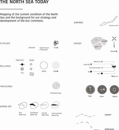
Figure 4. Continued.
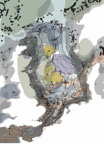
Figure 5. Detail: Dogger Bank (Inga Haveland Mannsåker, Malin Johannessen, Anna Haveland Stevenson, & Marthe Wernø, BAS 2019).
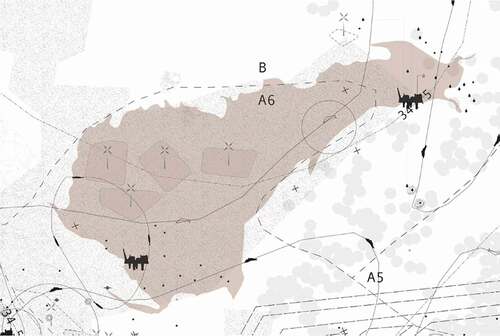
Figure 6. Combined fish-spawning areas (Inga Haveland Mannsåker, Malin Johannessen, Anna Haveland Stevenson, & Marthe Wernø BAS, 2019).
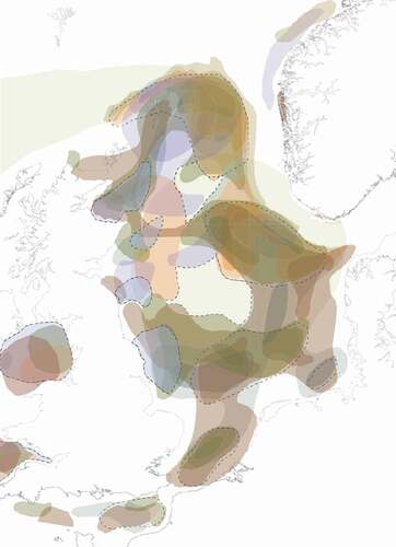
Based on this reading of the sea, the project identified a series of ecological recovery zones with different seasonal properties. These dynamic zones expand the established system of marine protected areas, and are marked by characteristics found in sea creatures, such as camouflage, signalling a seasonal recovery zone; the state of alert shut-down (seal) for monitoring zones, filtration (baleen whale) for lightly protected zones, as well as both constant and seasonal protective zones. (]. Aiming for the creation of zones with the qualities of three-dimensional interactive organisms, the new marine protective areas move around the North Sea according to seasonal requirements; for example winter and spring spawning areas become seasonal conditional zones subject to monitoring, where the level of protection can increase to protect the species (camouflage) and on which permission for other activities depends (filtration). Hence the proposal is based on contingent conditions in the North Sea. Rather than aiming for ecological recovery through static forms of enclosure, dedicated zones are elastic – expanding and contracting according to the requirements determined through seasonal behaviour and the fluctuating estimated urgency of protection.
Figure 7. Recovery Zones, common zone, research areas and research stations, North Sea Ecocommons. (Inga Haveland Mannsåker, Malin Johannessen, Anna Haveland Stevenson, & Marthe Wernø BAS, 2019).
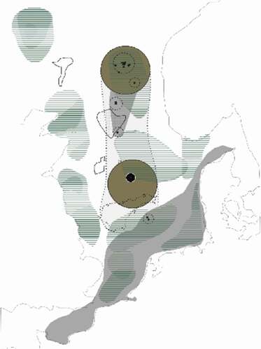
Figure 8. Model sketching new recovery zones, 2019 (Inga Haveland Mannsåker, Malin Johannessen, Anna Haveland Stevenson, & Marthe Wernø BAS 2019).
New Common ZoneFootnote4
A further objective for the Decade of Ocean Science is to deliver a ‘predictable’ ocean, where ‘society has the capacity to understand current and future ocean conditions’ (UNESCO and IOC, Citation2019). The project ‘New Common Zone’ developed from research on the predictability of one of the major threats for North Sea nations; sea-level rise. Departing from the fact that sea-level rise will cause the coastline to advance into the land, and based on the measured logic of Exclusive Economic Zones, this project proposes a hypothetical New Common Zone to be opened up in the centre of the North Sea, corresponding to the areas that will be submerged. It also includes the Dogger Bank as a vital cultural heritage (). The project refers to the RCP 8.5 calculation of an estimated 200 cm sea level rise by 2100 (Pachauri & Mayer, Citation2015).
Figure 9,10. New Common Zone (Li-Cheng Chen, BAS 2019).
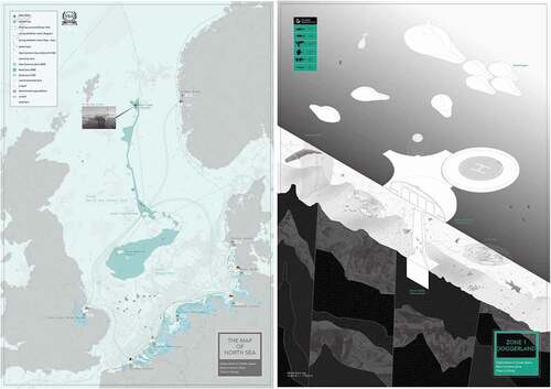
The common zone reacts to the territorial division of the North Sea. It is managed and shared by an instrument proposed by the project author; the North Sea Alliance, which would be formalised through a Convention between the six surrounding countries Norway, Denmark, Germany, The Netherlands, Belgium and the United Kingdom. Similar Common Zones are predicted to appear in other world seas and oceans. Within this zone, two different types of structures and uses are described in more detail; firstly, for the survival of threatened North Sea species a protected Ocean Tank and a submerged Gene Bank are proposed, and secondly an Ocean Memorial of «Floating Lands» is envisioned to store cultural relics, endemic species and special buildings that will otherwise be flooded in the coming century.
The project outlines a strategy despite the difficulty and constant inaccuracy of predictions – it counts on contingency to strengthen the long-term vision. As sea-level rises, the New Common Zone expands, opening up a series of negotiable possibilities. It also renders visible the landscapes and artefacts that sea-level rise will conceal. The explicit depiction of such floating artefacts, dislodged from their national homelands, brings home the value of a common refuge in face of a common problem, and aims to inspire a culture of collaboration. While the project is based on the current forms of enclosure around the North Sea through coastal base-lines and Exclusive Economic Zones, it also playfully inverts this system by taking it to the extreme and rigidly adhering to the imposed 200 nautical mile border in an advancing sea.
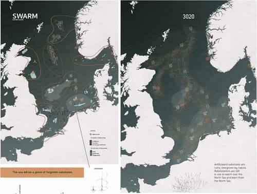
SWARM–Grave of Forgotten SubstratesFootnote5
The project Swarm reacts to the Decade of Ocean Science objective to deliver a ‘clean’ ocean, where sources of pollution are identified and removed. Set in the year 2100, a future scenario is created where current gas/oil and wind extraction technology is obsolete, leaving the industrial ruins of these extinct systems as artificial substrates on the seafloor and in the water column. These then become the habitat for recovering marine life. Here the sensitive and sophisticated robots ‘little archaeologists’ and ‘data-controllers’ operate in intelligent swarms, working together in seasonal circuits to avoid spawning fish and to monitor the health and cultural value of the North Sea. Ultimately, (in 1000 years) the North Sea ecosystem will be restored and the robots retired. () Swarms use collective intelligence. Ironically, the project robots interact more intelligently to the marine environment than the humans had in the previous phase of development. Such an elaborate system of monitoring and restoration makes a critical comment on the way we are currently unwittingly creating such future scenarios.
The preliminary phases of this project were inspired and influenced by „Robots in Distress“, a project by artists Boredomresearch which uses computer technology to simulate how robots „live and die“ in the plastic sea of the Venice lagoon- a startling vision but which also appeals aesthetically and emotionally through the semi-realistic but dreamlike visuals.Footnote6 The sub-surface sea remains a hidden, secret and invisible world to most of the public. Both „Robots in Distress“ and „The Swarm“ open up this world in its dystopic reality as a type of junkyard of the industrial era.
Figure 11,12. The Swarm, AI assisting the recovery of the North Sea in intelligent swarms (Justine Sleurs, Bas 2019).
Discussion
Why are These Approaches Useful to Planning Practitioners?
One of planning’s most important tasks is to look to the future (Hillier, Citation2010). On land, planning is not etched in stone- subsequent generations reassess earlier planning decisions and demolish buildings, re-establish ecological corridors, bury motorways, close down nuclear power plants and take a range of measures to restrict emissions. Citizen’s initiatives reassert common visions for critical areas. Following almost one generation of MSP (20 years on), and on the eve of its legislative ‘solidification’ (European Parliament and the Council of the European Union, Citation2014), a critical evaluation of methods and approaches should be highly productive. Designers with heightened spatial understandings and greater artistic freedom can potentially captivate the imagination of a broader range of society, coinciding with a call for greater participation in a common sense of stewardship for the largest commons on earth – the Ocean –, and in particular for Europe’s regional seas.
Artists ask different questions – leading to different answers. A full description of the artistic research carried out within the ‘Explorations in Ocean Space’ course is outside the framework of this paper, however one example is described in connection with the project ‘The Swarm’- here the artistic question was concerned with how technological interventions exist at the limits of human comprehension and how, in many cases, action leads to further problems.
Architecture students also ask different questions and have greater artistic freedom in their spatial representation of potential answers than marine spatial planners. The three projects discussed here, however demonstrate how Invisibility, Contingency and Enclosure can be addressed creatively in spatial proposals steered by climate urgency and the declining ecological condition of the North Sea. Their role for planning practitioners is therefore mostly to serve as pre-planning public interface; to expose, represent and draw attention to the hidden dimensions of ecological degradation in the North Sea, and to sketch out spatial management directions that re-establish the North Sea as an integrated ecological unit, rather than a fragmented political space. Such projects profit from techniques of representation that potentially draw a broader range of the public closer to the issues at stake. This is one way to improve public ocean literacy, since all projects are based on spatial analysis of current scientific research. Improved ocean literacy can, in turn, shift public opinion. While the ecological reality is harsh, the projects also serve to stimulate the public imagination. We believe that it is finally the imagination that enables a translation of statistics into spatial experience and that it is the comprehension of this experience that will pressurize authorities into placing environmental questions at the forefront of planning. As the public becomes more aware of ocean degradation, not only a field of debate, but also a minefield of design questions is unleashed. The projects described here provide a much-needed social, sensory and aesthetic dimension to what has largely been treated as an exclusive techno-scientific domain.
At a time when the ecological crisis is a global preoccupation, different forms of narration are needed to recount today’s most critical story. Critics have asserted that the current ecological crisis is accompanied by a crisis of the imagination (Ghosn & Jazairy, Citation2018), (Sijmons & Hajer, Citation2020). In their project ‘Pacific Aquarium’, Design Earth aim to render the ocean visible, and to ‘bring remote scales, uncertain futures and intangible scientific concepts, such as climate change, to the personal realm’. (Ghosn & Jazairy, Citation2017) An urgent collective, cross-disciplinary effort is required in order find workable approaches to the invisibles, the unpredictable and the enclosed in the world’s oceans and seas. The projects discussed this paper demonstrate possible ways to reimagine the spatial arrangement of the North Sea firstly as a commons and secondly as a spatial system in need of planning for ecological recovery.
Disclosure Statement
No potential conflict of interest was reported by the author(s).
Additional information
Funding
Notes
1. Final presentation 16.12.19, „Explorations in Ocean Space- from Bergen to the North Atlantic, Bergen School of Architecture, with guest critics Territorial Agency and Axel Wieder, Director Bergen Kunsthall.
2. The master-level design studio „Explorations in Ocean Space- from Bergen to the North Atlantic“ was taught in Autumn semester 2019. The previous researrch was carried out by the author as recipient of a Marie-Curie post-doc Fellowship at the TU Delft, Grant nr 753,682.
3. Project authors: Inga Haveland Mannsåker, Malin Johannessen, Anna Haveland Stevenson, & Marthe Wernø, BAS 2019
4. Project author: Li-Cheng Chen, BAS 2019
5. Project author Justine Sleurs, BAS 2019
6. ‘Robots in Distress’ was produced in 2017 during the FEAT (Future Emerging Art and Technology) Residency Programme, funded by the European Union’s Horizon 2020 research and innovation programme. It was developed in collaboration with SubCULTron and researchers at the Artificial Life Lab (Karl Franzens University, Graz Austria), who are creating the world’s largest underwater robot swarm to monitor the heavily human polluted Venice Lagoon. https://boredomresearch.net/wp/portfolio/robots-in-distress/ accessed 14. November 2021.
References
- Altarelli, G., Beniada, E., Lepoutre, M., Gugger, H., Couling, N., and Blanchard, A. (Eds). (2012). Territorial constitution 2: A pool of resources, in: Barents Lessons: Teaching and Research in Architecture (Zürich: Park Books, p. 48).
- Barham, E. (2001) Ecological boundaries as community boundaries: The politics of watersheds, Society & Natural Resources, 14, pp. 181–191. doi:10.1080/08941920119376.
- Bassan, N., Manea, E., Innocenti, A., & Musco, F. (2020) Land-sea interactions in marine spatial planning: A case study in Tuscany, in: N. Couling & C. Hein (Eds) The Urbanisation of the Sea: From Concepts and Analysis to Design, pp. 253–264 (Rotterdam: nai010).
- Bode, C. (2015) Energy extraction from wind: Marine re-territorialization in the North Sea, Scenario Journal, 5, pp. Extraction.
- Brett, A., Leape, J., Abbott, M., Sakaguchi, H., Cao, L., Chand, K., Golbuu, Y., Martin, T. J., Mayorga, J., & Myksvoll, M. S. (2020) Ocean data need a sea change to help navigate the warming world, Nature, 582(7811), pp. 181–183. doi:10.1038/d41586-020-01668-z.
- Carpenter, J. R., Merckelbach, L., Callies, U., Clark, S., Gaslikova, L., & Baschek, B. (2016) Potential impacts of offshore wind farms on North Sea stratification, PLOS ONE, 11(8), pp. e0160830. doi:10.1371/journal.pone.0160830.
- Chapman, K. (1976) North Sea Oil and Gas: A Geographical Perspective (Newton Abbot a.o: David & Charles).
- Couling, N., 2016. Seascapes_ the planning challenge of the century. In: History Urbanism Resilience, Planning & Heritage. Presented at the The 17th International Planning History Society Conference, Delft: TU Delft Open, 387–400.
- Couling, N., & Hein, C., Bensi, N. S., and Marullo, F. eds . (2018) Blankness: The architectural void of North Sea energy logistics, Footprint, 12, pp. 23.
- Couling, N., & Hein, C. (2020) The North Sea: New perspectives on the land-sea continuum, Couling, N., and Hein, C. eds. , in: The Urbanisation of the Sea: From Concepts and Analysis to Design, pp. 6–15 (Rotterdam: nai010).
- Couling, N. (2018) Formats of extended urbanisation in ocean space, in: P. Horn, P. A. d’Alençon, and A. C. D. Carduso (Eds) Emerging Urban Spaces- a Planetary Perspective, Vol. XII, pp. 219 (Cham: Springer International Publishing).
- Couling, N. (2020) Extensions and viscosities in the North Sea, in: N. Couling & C. Hein (Eds) The Urbanisation of the Sea: From Concepts and Analysis to Design, pp. 189–203 (Rotterdam: nai010).
- Couling, N. (2022) The Offshore Petroleumscape:- Grids, Gods and Giants of the North Sea, in: C. Hein (Ed) Oil Spaces: Exploringthe Global Petroleumscape (New York: Routledge)
- Cross, N. (2006) Designerly Ways of Knowing (London: Springer-Verlag).
- Draget, E. (2014) Environmental Impacts of Offshore Wind Power Production in the North Sea. A Literature Overview (Oslo: WWF).
- European commission, (2014) Communication 52014DC0254, Innovation in the Blue Economy: realising the potential of our seas and oceans for jobs and growth.
- European Commission, 2014. REPORT FROM THE COMMISSION TO THE COUNCIL AND THE EUROPEAN PARLIAMENT The first phase of implementation of the Marine Strategy Framework Directive (2008/56/EC). Brussels, No. COM(2014) 97 final.
- European Committee (UK). (2015) The North Sea under pressure: Is regional marine co-operation the answer? London: House of Lords, HL, Paper No. 137.
- European Parliament and the Council of the European Union. (2014) Directive 2014/89/EU Establishing a Framework for Maritime Spatial Planning.
- Faludi, A. (2018) The Poverty of Territorialism: A Neo-medieval View of Europe and European Planning (Cheltenham, UK: Edward Elgar Publishing).
- FAO. (2020). Salmon’s upward growth trajectory grinds to a halt over COVID-19. FAO, GLOBEFISH |- Information & Analysis on World Fish Trade.
- Flannery, W., Ellis, G., Ellis, G., Flannery, W., Nursey-Bray, M., van Tatenhove, J. P. M., Kelly, C., Coffen-Smout, S., Fairgrieve, R., Knol, M., Jentoft, S., Bacon, D., & O’Hagan, A. M. (2016) Exploring the winners and losers of marine environmental governance/Marine spatial planning: Cui bono?/“More than fishy business”: Epistemology, integration and conflict in marine spatial planning/Marine spatial planning: Power and scaping/Surely not all planning is evil?/Marine spatial planning: A Canadian perspective/Maritime spatial planning – “ad utilitatem omnium”/Marine spatial planning: “it is better to be on the train than being hit by it”/Reflections from the perspective of recreational anglers and boats for hire/Maritime spatial planning and marine renewable energy, Planning Theory & Practice, 17(1), pp. 121–151.
- Flannery, W., Toonen, H., Jay, S., & Vince, J. (2020) A critical turn in marine spatial planning, Maritime Studies, 19(3), pp. 223–228. doi:10.1007/s40152-020-00198-8.
- Gee, K., & Siedschlag, D. (2019) A place-based perspective on marine & coastal space, Europa XXI Marine and Coastal Space, 36, pp. 1–16.
- Ghosn, R., & Jazairy, E. H., Design Earth. (2018) Geostories: Another Architecture for the Environment (New York: Actar).
- Ghosn, R., & Jazairy, E. H. (2017) Leviathan in the aquarium, Journal of Architectural Education, 71(2), pp. 271–279. doi:10.1080/10464883.2017.1340777.
- Haraway, D. J. (2016) Staying with the Trouble : Making Kin in the Chthulucene (Durham : Duke University Press).
- Harvey, D. (1989) The Urban Experience (Oxford: Blackwell).
- Hillier, J. (2010) The Ashgate Research Companion to Planning Theory : Conceptual Challenges for Spatial Planning (Farnham, Surrey, England: Ashgate).
- Jay, S. (2010) Built at sea: Marine management and the construction of marine spatial planning, The Town Planning Review, 81(2), pp. 173–191. doi:10.3828/tpr.2009.33.
- Jay, S. (2020) Measured as the water flows: The striated and smooth in marine spatial planning, Maritime Studies, 19(3), pp. 255–268. doi:10.1007/s40152-019-00158-x.
- Jørgensen, A.-M. (2020) The anthropogenic seascape and the energy transition: The need for a new perspective on marine nature and human-made structures, in: N. Couling, and C. Hein (Eds) The Urbanisation of the Sea: From Concepts and Analysis to Design (Rotterdam: nai010, pp 165–176).
- Katsikis, N. (2014) On the Geographical Organization of World Urbanization, MONU, 20.
- Latour, B. (2004) Why has critique run out of steam? From matters of fact to matters of concern, Critical Inquiry, 30(2), pp. 225–248. doi:10.1086/421123.
- Latour, B. (2008) What Is the Style of Matters of Concern? (Assen: Uitgeverij Van Gorcum).
- Leisering, W. (ed.). (2000) Putzger Historischer Weltatlas, 1 ed. (Berlin: Cornelesen).
- Magnaghi, A. (2003) Le projet local.
- Miller, M. B. (2012) Europe and the Maritime World: A Twentieth-century History (New York: Cambridge University Press).
- Oliver, T. (2019) Wind farms threat grows, Fishing News, 12 August.
- Pachauri, R. K., & Mayer, L., Intergovernmental Panel on Climate Change (eds). (2015) Climate Change 2014: Synthesis Report (Geneva, Switzerland: Intergovernmental Panel on Climate Change).
- Palmesino, J., & Rönnskog, A.-S., (2021) Territorial agency - Oceans in transformation [online]. Available at https://www.territorialagency.com/oceansintransformation-3/oceans (accessed 15 January 2021).
- Peel, D., & Lloyd, M. G. (2004) The social reconstruction of the marine environment: Towards marine spatial planning?, The Town Planning Review, 75(3), pp. 359–378. doi:10.3828/tpr.75.3.6.
- Santoro, F., Santin, S., Scowcroft, G., Fauville, G., & Tuddenham, P., eds., 2017. Ocean Literacy for All: A Toolkit.
- Sekula, A. (2002) Fish Story, 2., rev. Engl ed. (Düsseldorf: Richter).
- Sijmons, D., & Hajer, M. (2020) 2050: An energetic odyssey — Persuasion by collective immersion, in: N. Couling, and C. Hein (Eds) The Urbanisation of the Sea: From Concepts and Analysis to Design (Rotterdam: nai010 pp. 221-228).
- Smith, G., & Brennan, R. E. (2012) Losing our way with mapping: Thinking critically about marine spatial planning in Scotland, Ocean & Coastal Management, 69, pp. 210–216. doi:10.1016/j.ocecoaman.2012.08.016.
- Statistics Norway, (2020) 2020-10-29 [online]. ssb.no. Available at https://www.ssb.no/en/jord-skog-jakt-og-fiskeri/statistikker/fiskeoppdrett/aar/2020-10-29 (accessed 13 Jan 2021).
- The Forgotten Space. (2010)
- Theutenberg, B. J. (1984) Mare Clausum et Mare Liberum, ARCTIC, 37, pp. 4.
- Uihlein, A., & Magagna, D. (2016) Wave and tidal current energy – A review of the current state of research beyond technology, Renewable and Sustainable Energy Reviews, 58, pp. 1070–1081. doi:10.1016/j.rser.2015.12.284.
- UNESCO and IOC. (2019) The Science We Need for the Ocean We Want. The United Nations Decade of Ocean Science for Sustainable Development (2021-2030) (IOC).
- van Tatenhove, J. P. M. (2016) The environmental state at sea, Environmental Politics, 25(1), pp. 160–179. doi:10.1080/09644016.2015.1074386.
- van Tatenhove, J. P. M. (2017) Transboundary marine spatial planning: A reflexive marine governance experiment?, Journal of Environmental Policy & Planning, 19(6), pp. 783–794. doi:10.1080/1523908X.2017.1292120.
- Vogler, J. (2000) The Global Commons: Environmental and Technological Governance, 2nd ed. (Chichester [etc.]: John Wiley & Sons).
- Walsh, C. (2020) Transcending land–sea dichotomies through strategic spatial planning, Regional Studies, pp. 1–13.
- Willsteed, E. A., Jude, S., Gill, A. B., & Birchenough, S. N. R. (2018) Obligations and aspirations: A critical evaluation of offshore wind farm cumulative impact assessments, Renewable and Sustainable Energy Reviews, 82, pp. 2332–2345. doi:10.1016/j.rser.2017.08.079.