
ABSTRACT
This study investigated the aquatic habitats on typical low hills in the Yitong River in Northeast China by applying the River Habitat Survey (RHS) method. The status of river habitats was evaluated on the basis of Habitat Quality Assessment (HQA) and Habitat Modification Score (HMS). The quality of habitats and the spatial distribution pattern of human disturbances were also analyzed. Results demonstrated that the HQA of 51 sites was between 24 and 66. On the basis of HMS, we found that 7.8% of the reaches are kept natural and 19.5%, 41.2%, 27.5%, and 3.9% of the reaches suffer from slight destruction, distinct degradation, serious degradation, and serious damage, respectively. HQA also exhibited a significantly negative correlation with HMS. HQAs did not evidently differ among upstream, midstream, and downstream habitats along the Yitong River. By contrast, HMS varied significantly. The upstream and midstream habitats were mainly influenced by water conservation structures. The downstream habitat was mainly affected by intensive land development for agricultural and construction purposes and by hydraulic structure construction in river embankments, discharge pipe installation, and bridge construction. Therefore, RHS results can intuitively reveal the conditions affecting river habitats and the factors causing river habitat degradation.
Introduction
A river habitat generally refers to physical structures, including riverbed, river bank, and riparian zone (Parsons et al. Citation2002; Chen Citation2007), along a river. The riparian zone is important for exchange of materials, energy, and parameters, and is simultaneously influenced by surface and underground water and is considered an ecotone with apparent edge effects. The compositions, structures, and distribution patterns of ecological communities and ecological environmental factors in riparian zones greatly differ from those in regions far from rivers. The ecosystem of riparian zones includes important practical and potential factors that increase the number of animal and plant species (Zhang & Peng Citation2003), enhance biodiversity and ecosystem productivity (Zhao et al. Citation2008), control water and soil losses, and adjust microclimates. River habitats should be evaluated to determine the causes of degradation and to provide references for river ecological restoration (Zheng et al. Citation2007). Habitat surveys and evaluation systems, such as the River Habitat Survey (RHS; Raven et al. Citation1997), have been established worldwide. The Environmental Protection Administration of Britain issued the manual of RHS field survey in 1997 in accordance with the recommendation of the European Water Framework Directive (WFD). The manual was fully completed in 2003 (Commission for the European Communities Citation1997; Environment Agency Citation1997; Environment Agency Citation2003). The plan is to collect essential RHS data regarding human disturbance factors by investigating the physical structures of rivers and evaluating habitat qualities on the basis of river type. Results help inform wise decisions in river environmental management, especially river ecological restoration and environmental impact assessments of construction projects that destroy the physical structures of rivers.
RHS is mainly composed of four parts: (1) field survey method of river habitats; (2) survey data management system; (3) Habitat Quality Assessment (HQA); and (4) Habitat Modification Score (HMS). Therefore, RHS is a set of technical systems for river habitat research. It integrates survey methods and evaluation models. It has also become a standard survey method recommended by WFD and a widely used method for river habitat evaluation (Raven et al. Citation2000; Hastie et al. Citation2003; Davenport et al. Citation2004; Szoszkiewicz et al. Citation2006; Vaughan et al. Citation2007; Cortes et al. Citation2008; Harvey & Wallerstein Citation2009).
In this paper, habitats along the Yitong River in central Northeast China were investigated by RHS at 51 sites. The habitat status was examined by using an RHS habitat evaluation model. Our study provides a scientific basis for ecosystem management in the Yitong River and proposes potential applications of RHS in China's river habitat evaluations for international environmental and ecological communities.
Methods
Study area
The Yitong River starts from the north side of Qingdingzi Mountain and Hadaling Mountains in Yitong County, Jilin Province, China ( and ). It flows southwest and converges with the Yinma River after it passes through Changchun City. It drains a river basin area of 8440 km2, is 342.5 km long, and has an average slope of 0.3‰. The reach above the Xinlicheng Reservoir in the suburbs of Changchun City is a low-hill region that suffers from excessive water and soil runoff because of sparse miscellaneous trees. The river valley is 1–2 km wide, with a curved watercourse, sediments, and pebbles in the river bottom. The region from the dam of Xinlicheng Reservoir to Xinhe Estuary comprises hills and tablelands. In this region, the river valley is 5–10 km wide, with a curved watercourse, silver sand, and sludge at the bottom. The Yitong River is also characterized by a vast and flat downstream region with a curved watercourse, many cutoff lakes, deep channels, and sediment on the bottom.
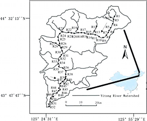
Figure 1. Drainage map of Yitong River and location of sampling reaches.
Survey indexes and methods
The RHS field method is a systematic assessment of the physical structure of a watercourse. Data collection is based on a standard 500 m length of river channel. Information is collected for each site, including grid reference, altitude, slope, geology, height of source, and distance from source.
RHS uses a 500-mile-long stretch as a survey unit. Survey data were collected by employing two mechanisms. First, basic maps, such as topographic map and distribution diagrams of soil types, were analyzed to obtain data, including altitude, slope, geology, terrain, and soil types in the study area. Second, a field survey of the bed, bank, and habitat 50 m from the top of the river bank was conducted. Ten survey sections were set at 50-m intervals along the study area. The land-use type on the top of the river bank and vegetation areas of the river bank covered 10 m of the length of the bank at the center of the survey sections as survey site. Other survey indexes covered 1 m of the reach at the center of the survey sections. After the section survey was completed, the overall features of the reach were recorded and missing information was supplemented. The heights, profile morphology, and land-use type of the river banks were recorded independently. The geometric features of the rivers, including the heights of river banks, shoal width, water depth, and water surface width, were determined at straight reaches with shoal habitats.
An RHS survey was conducted during base flow because during floods the flow pattern changes, water tables rise, and water becomes turbid. These factors influence the judgment on types of bed substrate. In this study, 51 reaches of the Yitong River were selected to investigate the river habitat in April 2015. Of these reaches, 1 through 14 are upstream, 15 through 35 are midstream, and the remaining ones are downstream (according to the flow, current velocity, drop, and sediment content of the river).
Habitat quality assessment
HQA evaluates the quality of river habitats in terms of naturalness, diversity, and rarity. It focuses on the types of river habitats and provides scores on the basis of occurrence, occurrence frequency, and distribution. Different evaluation items have various numbers of evaluation indexes that are generally determined by the corresponding types of natural river habitats. For example, RHS divides the bed substrate into nine types, but only eight types, namely bedrock, boulder, cobblestone, gravel, silver sand, silt, clay, and soil, are scored when the quality of river habitats is evaluated. Artificially hardened bed substrate is not considered natural and thus cannot be used as an evaluation index. Most evaluation indexes yield scores of 0–3, which are lower than 7. The score of the evaluation item is the sum of the subordinate evaluation index scores. The sum of 10 evaluation items is the HQA of the reach (Raven et al. Citation1998a). Different types or levels of rivers exhibit significantly different habitat structures. Therefore, the HQA of different types of rivers cannot be compared directly. For this reason, RHS established a reference point database composed of non-interference and slight-interference reaches described in previous studies. HQA is graded by using a reference point with similar geomorphic features (Fox et al. Citation1998).
Habitat modification score
The scoring system of indexes and the HMS computation mode are similar to those of HQA (Raven et al. Citation1998b). However, HMS evaluates the intensity of river habitat destruction by human activities; as such, this parameter is unlikely to be affected by river types. Therefore, the HMS of different types of rivers can be compared directly. Reaches with an HMS ranging between 0 and 2 likely maintain the original habitat well. Reaches with 3 < HMS < 8 exhibit slight habitat destruction. Reaches with 9 < HMS < 20 suffer from evident habitat degradation. Reaches with 21 < HMS < 44 experience serious habitat degradation. Reaches with HMS >45 display serious habitat damage. shows the basic hydrological data of Yitong River.
Table 1. Basic hydrological data of Yitong River.
Data analysis
The correlation between evaluation indexes was evaluated through Pearson correlation analysis. The contribution rates of evaluation indexes to HQA and HMS were determined through principal component analysis (PCA). The dominant influencing factor that affects the habitat evaluation of reaches was also identified. Differences in the significance of HQA, HMS, and related indexes among upstream, midstream, and downstream reaches were analyzed by conducting Kruskal–Wallis H test in SPSS. The correlation between HQA and HMS was analyzed through univariate linear regression. Significance level was set at 0.05.
Results
Reference points
The same reference system was used because all of the reaches in this paper pertain to low mountains or hilly landforms. Six reaches (1, 3, 4, 45, 46, and 50) far from cities and towns were slightly disturbed by human activities. As such, these reaches maintained a relatively natural river habitat. Therefore, they were chosen as the reference points for HQA evaluation. The first quartile of the HQA distribution of the reference points was considered as the evaluation standard of river habitats. The distribution scopes smaller than the first quartile were divided equally. The following HQA evaluation standards were used: very bad, bad, moderate, good, and very good.
Correlation analysis of evaluation indexes
Highly overlapping evaluation indexes reduce the reliability of results. Pearson correlation analysis revealed that the evaluation indexes of HQA were strongly correlated (). HMS includes 16 evaluation indexes, but 6 were scored 0 in all of the studied reaches. The correlations of the 10 remaining evaluation indexes were analyzed, and they were closely correlated with each other (). Therefore, PCA was necessary to evaluate the indexes of HAQ, and HMS was examined to verify the reasonability of chosen indexes.
Table 2. Pearson correlation matrix between metrics of Habitat Quality Assessment (HQA) and Habitat Modification Score (HMS).
Table 3. Pearson correlation matrix between metrics of Habitat Modification Score (HMS).
Principal component analysis
The PCA of HQA indexes revealed the following values: Kaiser–Meyer–Olkin = 0.552, Bartlett's test of sphericity = 132.6, and concomitant possibility = 0. This finding indicated that they are suitable for PCA. The first five principal components indicated that 77.9% of the index information can illustrate the spatial pattern of the HQA. On the basis of the loads of evaluation indexes, we observed that the first principal component mainly reflects A1, A3, A9, and A10 (Raven et al. Citation1998a); the second principal component mainly corresponds to A5 and A6; and the third to fifth principal components show A8, A7, and A4. The load of A2 was <0.6 in all of the principal components. This finding demonstrates the poor interpretation of the changes in bed substrate to river habitat. This phenomenon occurs because the 51 reaches are typical mountainous river habitats, where pebbles (16–64 mm) and cobbles (64–256 mm) are the main bed substrates. The difference among the reaches was not significant.
The PCA of HMS indexes revealed the following values: Kaiser–Meyer–Olkin = 0.514, Bartlett's test of sphericity = 130.777, and concomitant possibility = 0. Therefore, they are suitable for PCA. The first five principal components revealed that 77.238% of the indexes can indicate the spatial pattern of HMS well (). On the basis of the loads on evaluation indexes, the first principal component mainly reflects S3, S11, and S16; the second principal component mainly corresponds to S1 and S14; and the third to fifth principal components denote S15, S12, and S13. The loads of S5 and S9 were <0.6 in all of the principal components. This finding indicated the poor interpretation of the changes in banking and grass removal to river habitat. This phenomenon may be attributed to the high frequency of embankment behavior but low frequency of grass removal. PCA also demonstrated that HQA and HMS indexes can illustrate the spatial distributions of river habitat features and interference factors well without evident redundancy.
Table 4. Principal components of assessment categories of Habitat Quality Assessment (HQA) and Habitat Modification Score (HMS).
Evaluation results
The HQA of the 51 reaches ranged between 25 and 60 (). On the basis of the quality classification standard of river habitats, we found that 15 reaches (29.4%) were ‘very good’; 15 reaches (29.4%) were ‘good’; 12 reaches (23.5%) were ‘moderate’; 5 reaches (9.8%) were ‘bad’; and 4 reaches (7.8%) were ‘very bad’. The HMS of the 51 reaches ranged between 1 and 122. The results revealed the following: 4 reaches (7.8%) were slightly disturbed by human activities and are in good natural states; 8 reaches (15.7%) suffered from slight river habitat destructions; 22 reaches (43.1%) experienced evident habitat degradation; 14 reaches (27.5%) showed habitat degradation; and 3 reaches (5.9%) suffered from serious habitat destruction and thus are difficult to restore.
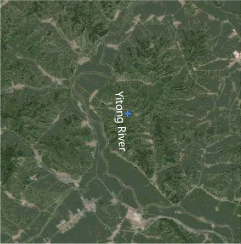
Figure 2. Satellite map of Yitong River basin.
Regression analysis indicated that HQA exhibited a significantly negative correlation with HMS (). Therefore, a high intensity of disturbance leads to poor river habitats. Spatially (), the upstream, midstream, and downstream habitats of the Yitong River did not evidently differ in terms of HQA (p = 0.931). Among the HQA indexes, 3, 7, 8, and 9 differed significantly (p < 0.05) because upstream reaches yield a low average water depth and comprise various habitat structures, such as erratic blocks and river islands. Moreover, upstream reaches are characterized by small population densities and enhanced vegetation in the outer side of the bank. Downstream reaches exhibit a small mean velocity and slope and developed wetland vegetation in the river bed and forest belts on river banks. Reaches close to cities and towns are generally composed of poor habitats, such as 9, 15, 16, and 51. This phenomenon is attributed to single-flow regime, simple land utilization for agricultural and construction purposes, and serious vegetation damage with low coverage. The HMS of upstream, midstream, and downstream reaches of the Yitong River greatly varies (p = 0.028). The Kruskal–Wallis test revealed that the HMS indexes significantly differed among 1, 3, 11, and 16 (p < 0.05).
Figure 3. Linear regressions between Habitat Quality Assessment (HQA) and Habitat Modification Score (HMS).
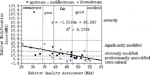
Table 5. Habitat Quality Assessment (HQA) and Habitat Modification Score (HMS) of sampling reaches in upstream, midstream and downstream of Yitong River.
Discussion
In the Yitong River, the upstream and midstream reaches differ from the downstream reaches in terms of distinct variations in human disturbance features and HMS values. Upstream and midstream reaches are characterized by steep terrains, low population densities, and small intensities of land development. Large reservoirs are also found because of rich water resources. As a result, water shortage occurs in the downstream reaches. Hence, ecological releasing should be applied to protect the health of the ecology in downstream reaches during hydroelectric resource development in the river basin. Ecological restoration in downstream reaches should also focus on forest reconstruction to enhance vegetation diversity, improve hierarchical community structures, and reduce the effects of non-point source pollutions on river water quality. River structures should be carefully planned to improve the management of household garbage and domestic sewage and to minimize the total amount of pollutants in the Yitong River.
Disclosure statement
No potential conflict of interest was reported by the authors.
Additional information
Funding
Notes on contributors
Yujia Song
Yujia Song is an associate professor in the Department of Environmental Engineering, Changchun University of Science and Technology, Changchun, P.R. China. Author's main research interests include environmental geography, ecological restoration in waters, environmental impact assessment and migration and transformation of pollutants.
Shoufa Song
Shoufa Song is a professor in Northeast China Coal Industry Institute of Environmental Protection, Changchun, P.R. China. Author's main research interests include ecological restoration in waters, migration and transformation of pollutants, watershed ecology.
References
- Chen T. 2007. Studies on habitat assessment of urban river in China's plain water network region [dissertation]. Shanghai: East China Normal University.
- Commission for the European Communities. 1997. Proposal for a council directive establishing a framework for community action in the field of water policy. Brussels: Commission for the European communities.
- Cortes RMV, de Oliveira SV, Hughes SJ, Ferreira MT. 2008. Combining habitat and biological characterization: ecological validation of the river habitat survey. Limnetica. 27: 39–56.
- Davenport AJ, Gurnell AM, Armitage PD. 2004. Habitat survey and classification of urban rivers. River Res Appl. 20: 687–704.
- Environment Agency. 1997. The quality of rivers and canals in England and Wales 1995. Bristol: NHBS.
- Environment Agency. 2003. River habitat survey in Britain and Ireland: field survey guidance manual (2003 version). London: Environment Agency.
- Fox PJA, Naura M, Scarlett P. 1998. An account of the derivation and testing of a standard field method: an example using river habitat survey. Aquat Conserv. 8: 455–475.
- Harvey GL, Wallerstein NP. 2009. Exploring the interactions between flood defence maintenance works and river habitats: the use of river habitat survey data. Aquat Conserv. 19: 689–702.
- Hastie LC, Cooksley SL, Scougall F, Young MR, Boon PJ, Gaywood MJ. 2003. Characterization of freshwater pearl mussel (Margaritiferamargaritifera) riverine habitat using river habitat survey data. Aquat Conserv. 13: 213–224.
- Parsons M, Thoms M, Norris R. 2002. Australian river assessment system: review of physical river assessment methods – a biological perspective. Canberra: Commonwealth of Australia and University of Canberra; p. 2–10.
- Raven PJ, Fox P, Everard M, Holmes NTH, Dawson FH. 1997. River habitat survey: a new system for classifying rivers according to their habitat quality. Edinburgh: The Stationery Office.
- Raven PJ, Holmes NTH, Dawson FH, Everard M. 1998a. Quality assessment using river habitat survey data. Aquat Conserv. 8: 477–499.
- Raven PJ, Holmes NTH, Dawson FH, Fox PJA, Everard M, Fozzard IR, Rouen KJ. 1998b. River habitat quality the physical character of rivers and streams in the UK and the Isle of Man. Bristol: Environment Agency.
- Raven PJ, Holmes NTH, Naura M, Dawson FH. 2000. Using river habitat survey for environmental assessment and catchment planning in the UK. Hydrobiologia. 422–423: 359–367.
- Szoszkiewicz K, Buffagni A, Davy-Bowker J, Lesny J, Chojnicki BH, Zbierska J, Staniszewski R, Zgola T. 2006. Occurrence and variability of river habitat survey features across Europe and the consequences for data collection and evaluation. Hydrobiologia. 566: 267–280.
- Vaughan IP, Noble DG, Ormerod SJ. 2007. Combining surveys of river habitats and river birds to appraise riverine hydromorphology. Freshw Biol. 52: 2270–2284.
- Zhang JC, Peng BZ. 2003. Study on riparian zone and the restoration and rebuilding of its degraded ecosystem. Acta Ecol Sinica. 23: 56–63.
- Zhao JY, Dong ZR, Sun DY. 2008. State of the art in the field of river habitat assessment. Sci Technol Rev. 26: 82–88.
- Zheng BH, Zhang Y, Li YB. 2007. [Study of indicators and methods for river habitat assessment of Liao River Basin]. Acta Sci Circumstantiae. 27: 928–936. Chinese.