
ABSTRACT
Although cities with World Heritage (WH) areas worldwide are socially active, specific social and cultural complexities are associated primarily with the abandonment and decay of districts. Contemporary habitation patterns in historic districts require technology to understand parallel realities in protected areas. This stakeholders-based approach benefits significantly from cross-referencing locative social media and open data sources. Therefore, the concepts put forward in this paper use evidence from an empirical case of WH areas in selected Spanish urban sites. The cartographic correlation of data identifies hotspots of activities and coldspots around services within each site. The results present two significant findings. The first confirms the successful implementation of a digital method to support current transitions for the historic city. The second demonstrates that social networks and open datasets can mirror contemporary social interaction in historic cities. Finally, the study calls on further investigating Artificial Intelligence-based assessments for the future of WH areas.
Introduction
Cities with World Heritage (WH) areas have functioned as urban settings promoting specific forms of habitation and consumption (Carvalho et al., Citation2019; Pendlebury, Citation2008). However, the types of cultural consumption observed in recent decades have questioned this model (García-Esparza, Citation2018; Nielsen, Citation2011). The Faro Convention (Council of Europe, Citation2005) recognized the value of heritage for society, and promoted cultural heritage protection as a “central factor in the mutually supporting objectives of sustainable development, cultural diversity and contemporary creativity” Since the beginning of the twenty-first century, some relevant innovations in international cultural policies have stressed that heritage is no longer considered on its own as a cultural objective. Still, it is regarded as part of a complex process for making concrete the global objective of sustainable development at the economic, social, and environmental levels (Council of Europe, Citation2011).
In this context emerged The Valetta Principles for the Safeguarding and Management of Historic Cities, Towns and Urban Areas (ICOMOS, Citation2011). Valetta already considered the intangible aspects of historic towns and urban areas as an expression of societies’ evolution, including daily life and contemporary activities. The Principles highlighted several aspects of change, and placing special emphasis in the effects of climate change for the habitability of historic buildings. The text stressed the negative impacts on communities’ displacement and the disappearance of cultural practices. Sustainable development is implicit when the document refers to the loss of places’ liveability, the lack of diversity and plurality, and particularly when it compels to improve the quality of life of residents and the quality of the environment. In parallel, the document requested procedures to be sufficiently informed, plural, and diverse.
After Valetta, a specific remark to the development dimension of culture was referred to within the International Development Agenda adopted in 2015 by the UN General assembly, the Agenda 2030. At that time there were two important UNESCO Reports. Re-Shaping Cultural Policies (UNESCO, Citation2017) is a policy study focused on the relationship between culture – in all its forms – and sustainable development. The Report on Culture: Urban Future was prepared in view of the Habitat III Conference (Pickard, Citation2016; UNESCO, Citation2016), where culture is recognized as a category linked to people, environment, and policies.
As such category, heritage conservation is called upon placing society at the core of the process of heritage-making to enhance social development process in historical contexts (García-Esparza, Citation2015; ICCROM, Citation2015; Jones & Leech, Citation2015; UNESCO, Citation2011). The New Urban Agenda 2030 clearly stablished the reasons for a new urban conservation approach in which conceptual transitions are still underway. Heritage is perceived now as a cultural ecosystem and as a system of values subject to be analyzed by a set of indicators linked to the social, environmental, and economic categories. And the implications of this are not yet fully analyzed and will mark the nature of heritage in the twenty-first century, particularly in cities where the key drivers of development take place (Bandarin, Citation2019; ICOMOS, Citation2019; Labadi et al., Citation2021).
After eleven years, the International Committee on Historic Cities, Towns and Villages of ICOMOS is reviewing the Valletta Principles. The new document proposes an evaluation of previous concerns regarding governance and management for historic cities but under the contemporary global context. The paradigms under assessment include new qualities for historic cities, climate change and its impact, the health crisis and urban demands, new applications of the circular urban economy to the historic town, and the impact of digital data analysis on cities. From the perspective of new approaches to governance, information about issues and practices are stressed to promote and guarantee conservation and enhancement. On the management side, new methodologies and tools are meant to help respond better to the current questions of protection.
In this context, to better comprehend the new conceptual transitions related to values and uses of historic sites, researchers are interested in knowing not just how the historic environment is enhanced in terms of space combination, connection, or reuse. In particular, in light of the social and cultural challenges the Agenda 2030 poses, these transitions are calling for comprehending real problems of engagement in participatory placemaking processes in historic sites and developing transparent assessment methods that are open and trustworthy. Then, to better accommodate these conceptual transitions, it is convenient to know whether districts keep or have lost the societal structure. If existing, understand its distribution and how eventual incompatible uses of space affect each other, or if conversely, uses and assets coexist equitably and respectfully.
The digital assessment of uses and assets in WH areas
In line with the latest recommendations from ICOMOS, the first objective of this research analyses the potential contribution of online data and user-generated content for understanding the contemporary socio-cultural trends in five medium-sized cities in Spain: Ávila, Cuenca, Salamanca, Segovia, and Toledo. Researchers chose these five cities for the presence of WH areas nominated for their historic centers and not exclusively for their monuments. In addition, these cities share geographic and demographic similarities, symbolic heritage, and cultural links. The five cities, ranging in size from 52,000 inhabitants in Segovia to almost 145,000 in Salamanca, were designated World Heritage sites in the late twentieth century. In line with the second objective, the similarity of these cities benefits the comparison of data about location, intensity and dispersion of activities and services.
Historic urban settings have traditionally been analyzed through studies based on in-situ fieldwork. Today, the extensive information available online in the form of datasets, surveys, and mobile apps makes it possible to ascertain how people interact with and within the historic environment (Couldry & Hepp, Citation2018). Ultimately this provides a level of digital analysis of habitation tendencies which can give the stakeholders proper instruments for decision-making (Ginzarly et al., Citation2019; Martí et al., Citation2019; Vanhatalo & Partanen, Citation2022). Furthermore, digitization contributes to cross-referencing place-based data with the particularities of contemporary patterns in specific urban geographic contexts.
Many cultural heritage academics and urban planners regard social media as a form of participatory praxis through multidisciplinary methods for the engagement of communities in collaborative management (Burkey, Citation2021; Jaillot et al., Citation2020; Leszczynski, Citation2018; Li et al., Citation2020). Online sources can help to build a multifocal approach in search of widespread agreement on socio-cultural issues. However, the internet provides information on highly valued aspects of the urban landscape such as buildings, services, daily practices, and people's experiences, which can be visualized using mapping and GIS tools (Altaba & García-Esparza, Citation2018; García-Esparza & Altaba, Citation2020; Kahila-Tani et al., Citation2019). To date, the use of locative social media in the context of urban WH areas has not yet been fully explored.
However, in the fields of tourism, media studies and urban planning there is mounting scientific evidence of the vital importance of social media in understanding the engagement of individuals with cities (Koufodontis & Gaki, Citation2020; Wong et al., Citation2020). Today, the Internet plays a vital role in socio-cultural appraisals, including a wide range of values, such as vibrancy and authenticity, connected to social life in cities (Chen et al., Citation2019; Salet, Citation2021). Thus, social media and online applications specifically provide unprecedented opportunities for understanding social trends linked to urban fluctuations by using big data and citizen perceptions (Anejionu et al., Citation2019; van der Hoeven, Citation2020).
According to the literature, although digital assessment and social media provide unprecedented opportunities for understanding some urban dynamics, they can be unsuccessful in accurately reflecting the complexity of places (Qian, Citation2022). This may be due to a partial availability of data or to a partial consideration and interpretation of data and its framework (Haltofova, Citation2020; Xu et al., Citation2022). In fact, social media has a set of very specific stakeholders that make studies rely on very specific forms of cultural consumption (Martí et al., Citation2019). Another limitation of these methods is the fact that uses of space and values evolve over time and may have strong local links, so that the validity of results are temporary and local, hampering consistency in the provision of a valid amount of georeferenced data (Sloan & Quan-Haase, Citation2017).
Although these methods are regarded by literature as effective proxies for solving contemporary urban issues, the digital place-based appraisal favoured by mixed-source methods is yet to be explored in depth in many European WH areas, rapidly accommodating functions and roles and becoming increasingly diverse with stakeholders from a wide range of cultural backgrounds and socioeconomic positions (Erjavec & Ruchinskaya, Citation2019). Accordingly, this investigation helps to contextualize and recognize the specificities of sites and presents a method that allows the incorporation of all sorts of datasets in order to address the reasons and find remedies for specific societal structures, distributions, and uses of space. Thus, ascertaining how citizens’ uses and values correlate to structural changes in urban protected areas makes it possible to pave the way toward correcting potential imbalances for the future.
In this study, five sources of information provide quantitative data that showcase both external and internal district conditions and reflect stakeholders’ interactions, (Yang, Citation2022). The Foursquare digital application includes information about users’ activities and locations, mainly about leisure and areas of cultural interest (Saker, Citation2017). Google Maps offers a series of recorded sites of small business and public services such as schools, universities, libraries, and monuments (Green & Bennett, Citation2019). While Foursquare data contributed anonymously, provide a pattern which shows the activity nuclei and dispersion through the WH area, Google data make it possible to visualize the placement of services essential to the daily life of districts. The freely available urban data from the Spanish Inspire Cadastre provide insight into the state of conservation and generic uses of buildings by districts, while the data retrieved from the National Statistics Institute (NSI) provide a sector-by-sector analysis of the population census. Finally, cartographic data serve as a representation framework for the analysis of the district scale and identify community interaction.
Parameters of hotspots and coldspots
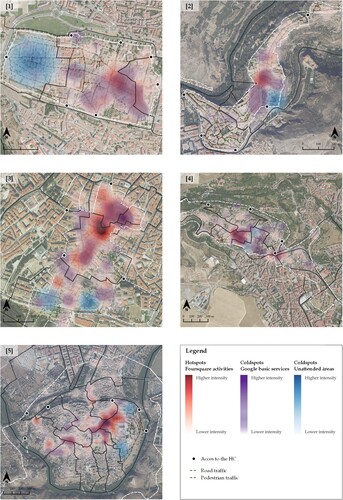
The visualization of data exposes the manners stakeholders interact with the built environment and the cross-referring of information on how interaction affects the social structure of districts. In this study, hotspots are the most visited sites defined by Foursquare activities, which are geolocated points labeled by category. The analysis of stakeholders’ forms of consumption for all five cities show an average of 51% of topics relating to bars and restaurants, 14% linked to culture, 13.5% connected to shopping, 12% associated with hosting services, and finally, 9.5% to outdoor and recreational activities.
Culture, as highlighted by Foursquare users, differs from the cultural services retrieved from Google Maps. In Foursquare, the Culture label mainly represents architectural landmarks and other tangible sources associated with the physical shape of the WH area. Foursquare categories concentrate on one or two specific zones in the five cities. Irrespective of the size of the WH area, these zones are mainly located in one or two districts, while the remaining districts are virtually ignored. Cross-referencing hotspots with the percentage of non-primary residences provides an initial appraisal of differences between districts. For example, in Cuenca, the district where Foursquare activities concentrate has 71.5% of non-primary residences, while in Segovia the figure drops to 33.03%. The opposite happens in Toledo, where the highest rates of non-primary residences, ranging from 30.09% to 42.52%, have few or no Foursquare activities. In this case, the size of the protected area may well explain this fact.
Coldspots relate to the analysis of primary and cultural services along with other indicators such as accesses, building uses, and population density. Coldspots are places with fewer visitors, but they can also be depopulated spaces or places neglected by administrations and residents, that is, empty structural places. Among the services found in WH areas, the basic ones account for 63%, and cultural ones, museums, and traditional centers, for the 37%. Grocery stores represent 55% of the basic services, while education and health account for 17% and 12%, respectively. When researchers cross-refer, compute, and visualize coldspots data in a GIS environment with cadastre data, it provides a clear idea about the spatial implications of their distribution, which mainly pertain to the less dense districts.
Technology-based behavioral patterns
Contemporary WH areas are changeable places that host parallel patterns. According to results, hotspots data, based on Foursquare activities, showed two clear situations. The first is found in Ávila, Segovia, and Salamanca where in terms of density, location, non-primary residence and age data, the more populated districts host visitors’ activities. The second situation is found in Cuenca where the visitors’ promotion of the WH area occurs in the less dense district where elderly people still live, and the percentage of non-primary residences doubles that of the denser one.
Coldspots data, based on Google Maps basic and cultural services, revealed an interesting pattern. These are generally closely related to hotspots, but mainly situated in low density districts. This happens in all cities except Ávila. An analysis of accesses to low-density districts showed that basic services, despite being located in less dense districts, are well connected to thoroughfares that act as corridors through which hotspot users have to pass.
In line with the first objective of the research about the mixed-source analysis to evaluate the conditions of protected areas according to specific social and cultural complexities demonstrates its capability. The source, through the analysis of hotspots and coldspots, provides different scenarios in each city that, despite showing clear and similar patterns, evidence some exceptions as well. Besides, data reveal that locally dependent particularities exist and may condition the success or imbalance between districts. There are two aspects of hotspots in WH areas which appear to be extremely beneficial in these cases. Firstly, they boost the economy with visitors’ activities and secondly, they retain population and services at least in well-connected locations.
Hotspots activities normally present two main point clouds in two or three districts of each area and mainly, in denser, and perhaps more appealing districts in terms of mainstream forms of heritage consumption. The exception in this study is Cuenca and finds its explanation by parameters of morphology and accesses. Nonetheless, similarities are revealed in the role hotspots play today at WH areas. Fundamentally, all hotspots are linked to activities surrounding one of the most iconic landmarks, although visitors’ activities are not necessarily associated to it.
Data demonstrate that today the contemporary historical area does not only host architectural values, but also social ones linked to leisure and recreation. Hotspots demonstrate how WH nominations have influenced the visual nature of WH areas. But simultaneously, it appears that those heritage-led models have coldspots where mainstream forms of culture and valorization are challenged. These marginal areas receive less attention, evolve and decay at a slower pace and may reveal themselves as future assets with alternative hidden secrets that consumer culture does not currently perceive. These ignored coldspots may need further study with more data, even for the entire WH area.
An additional analysis is necessary because, while online data reveals additional information that are not easily detected through on-site analysis, online data does not in the least depict daily life practices. Subsequently, contemporary culture-making through notions of local craftsmanship and art performance are conspicuous by their absence as part of the city's intangible heritage or creative industries. And this is a consequence of policies and norms articulated around the economic dimension and cultural forms of consumption behind WH.
Researchers demonstrate that some unattended or peripheral coldspots, however, display a punctual concentration of activities. This is due mostly to the fact that while Foursquare users are mainly interested in the visual appealing of the historical values, some locals tend to show interest in places relevant to their daily life activities. The references to these “unattended” coldspots correspond to locations in WH areas where different socio-cultural processes take place and provide a particular charm as alternative contemporary scenarios.
Through the mixed-source analysis, the study confirms the existence of commonalities and differences in the understanding of these protected areas. Specifically, the first tendency in results reveals that historical heritage, cultural representations, and activities are assets of great importance to visitors; locals or foreigners. When Foursquare users express interest in certain activities, gastronomy, tourism, sightseeing, trips, festivals or entertainment, locals also associate the physical environment with social, leisure, and economic values. In contrast, the opposite tendency highlights how for some locals, certain tangible attributes are not as important as others. This is the case of services and intangible interactions which affect the setting where daily life develops, and in turn shapes the domestic nature of the district.
In line with the second objective of this research about the validity of a place-based analysis looking for successful and balanced habitation futures in WH areas, the data and layout of cities demonstrate that the success of WH nominations is dependent on several factors and the pre-existing characteristics of places. These factors create more appealing inhabited districts or decaying ones, both in physical and social terms. Despite preserving the integrity of the urban fabric, the data suggest that the conservation of WH areas relies on the social structure of districts as one of the pillars guaranteeing an enduring habitational success. The dual nature of central zones of WH areas appears to be extremely beneficial in retaining population in these districts. Nonetheless, an excessive concentration of services in a specific area gives rise to imbalances between districts, both in terms of density and residence, and affects the societal structure.
The main issue highlighted by the results of the study is whether the nature of WH areas has undergone a complete transformation, adapting to specific forms of contemporary valuation. Accordingly, results demonstrate two major issues related to the second objective: (1) The relevance and dependence to mainstream forms of culture consumption and leisure activities; and (2) The spatial tensions between districts reflected by hotspots and coldspots and their socio-cultural relevance for all the spheres analyzed: density, services, locations, accesses, housings, and age ().
Figure 1. Distribution of hotspots according to Foursquare data, and analysis of coldspots defined as unattended locations and basic services location in the less dense districts of the five WH areas: (1) Ávila; (2) Cuenca; (3) Segovia; (4) Salamanca; (5) Toledo.
The results show how WH nominations have influenced the visual nature of historic cities. Depending on their attributes, attention to specific points may detract from other major vantage points across the setting. The urban scenery attracts significant attention from visitors and poses major challenges to equilibrate pressures between districts, especially in those hosting everyday living spaces. Hotspots and coldspots reflect these pressures when activities and services in one district provoke the opposite effect in the adjacent ones. This in turn becomes restrictive, preconditioning knowledge and place experience towards future. According to hotspots and coldspots analysis this can provide attractive insights and actions for the urban realm, while in other instances this simply results in problematic transfers. Either way, the potential effect of these tendencies on resource management is significant.
Finally, while surprisingly scant attention has been given to documenting these important links to people's experiences, perceptions, and activities across WH areas, this study puts forward data which help to illustrate future possibilities. When analyzing data to determine the success of a place, it is critical to recognize that individuals tend to be influenced by the pre-existing conditions and any hidden associated issues of places. These preconditions establish the rules on the forms of interaction with space and behavior. Accordingly, hotspots and coldspots patterns shed light on mainstream forms of culture and to places where alternatives to dominant pressures can be otherwise articulated to ensure inclusiveness, to balance citizens’ needs and interests, and to provide equilibrium in issues such as emptiness, abandonment, conservation, and decay.
The analysis presents two major findings. Firstly, social networks can mirror the social interaction observed in urban public spaces, establishing the dynamics of inhabitants and visitors within the historic city. Specifically, services and activities in open spaces such as central squares and nearby streets are identified consistently, as Google Maps services and Foursquare user activities coincided in all districts of the five cities. Cadastral data is essential in establishing a correlation between these and ongoing social fluctuations at city and district level. Accordingly, the digital method, that helps analyze and interpret data retrieved from cadastre and online applications has proved reliable and provides clear outputs to identify patterns in the five WH areas.
Both the method and the data cross-referencing serve to understand how contemporary situations may document and better manage future scenarios. The data from online applications and cadastre jointly defined two clear tendencies despite the different morphologies and functions displayed by districts and WH areas. First, while data denotes that all WH areas remain socially active, it is also proved that social and cultural imbalances exist. Thus, identifying hotspots and coldspots for services and activities offer a comprehensive, perhaps more accurate, portrayal of urban patterns in WH areas. Second, analyzing districts is practical when studying dynamics at these levels, showing how WH areas adapt to new social, economic, and mobility-related needs according to morphology.
Among the lessons learned in this study, data analysis suggests that districts’ imbalances within WH areas could be softened through participatory processes. In this case, despite the local administrations considering their management as successful in safeguarding the historical value and boosting the economy and employment rates, data reveals a margin for improvement. Governance and management must incorporate the social and environmental spheres of development to avoid inequalities between districts and, particularly, to boost measures that affect the quality of life in the entire WH area. Accordingly, a peril exists in not finding the balance between local contexts and ethical implementation of sustainability matters for quality urban habitats.
Further digitization for WH sites
Findings stress that digitization helps filter issues when assessing both sites to visit and live in. Further digitization to incorporate participation data can happen through Artificial intelligence (AI). This digital realm uses algorithms for qualitative data assessment to determine the character of a place and to take on increasingly relevant evaluation tasks that affect cities and inhabitants. How these data and tools are managed will determine the purpose that society attaches to historic places. The digital endeavor requires critical, multidisciplinary, and ethical teams to understand how digital technologies, processes, and policies affect the historic environment's economic, environmental, physical, and social performance. The process is complex and costly, so it is conspicuous by its absence in many historic places.
Further digital research into services, methods, and activities should help determine if decision-making fosters success for habitation futures. Despite today's success and equilibrium relying on locally dependent sustainable development policies, practices, and decision-making, heritage areas are nowadays recognized as commercial assets that acquire rhythms and functionalities that differ from the rest of the city. These reshaped environments may take on contradictory roles and functionalities over time. Perhaps the digital analysis of the factors and complex relationships that are gradually emerging can help improve governance and management and avoid biased perspectives that are otherwise too complex to examine (Dines, Citation2018; Díaz-Parra, Citation2020).
In this context, Machine Learning (ML) serves to analyze a variety of characteristics, including fundamental necessities, access to basic services, accessibility, housing adequacy, environmental pollution, access to green places, and overall welfare. This form of digital appraisal is linked to current research paths for using and establishing data treatment (Mhasawade et al., Citation2021; Yeung & Fernandes, Citation2022). Compared to prior methodologies, these forms of analysis are known to produce higher or at least equivalent accuracy outcomes. ML approaches may provide a variety of advantages for WH areas, including the ability to handle big data of varied sorts, structures, and scale (Molnar, Citation2019).
Machine Intelligence analyses data and explains how, after sorting information, it might assist in equilibrating or polarizing judgments. This fact has consequences on how the historic city has been preserved because datasets analysis may provide a critical appraisal of the politics behind data signification, vested interests, and eventual polarized decisions (Brooker, Citation2022; Poirier, Citation2021). In this line of thought, researchers want to explore and apply ML to the assessment and geolocation of qualitative data to incorporate them into the digital appraisal of historic cities.
Conclusion
The results of this study prove that inhabitants and visitors within WH areas are dependent. Nonetheless, while a first tendency links the urban layout and architecture to esthetic aspects, the second dissociates culture and consumption from other aspects of the city, establishing a semantic and spatial separation from the surroundings. Further research would be advisable to examine other factors affecting disparities between districts and cities. Although according to cadastral data no significant areas in these cities are affected by abandonment and decay, depopulation exists, and these factors can be associated with socio-cultural pre-existence and existing conservation policies. Other factors requiring further analysis involve understanding and adapting WH areas’ contemporary functions and their constraints in satisfying inhabitants’ needs.
This approach exposes new forms of appraisal for WH sites. This form of assessment includes new qualities for historic cities and how those are perceived. This research reveals the global need to continue developing more prominent and highly skilled technology-based forms of analysis that drive towards an increasingly innovative form of governance and management of heritage sites in the twenty-first century. It entails understanding the parameters necessary for working and living with digital tools and mitigating their risks to shape future places and societies. This new paradigm for historic cities involves social and embodied digitization through immersive media, data analysis and data ethics. As decision-making grapples with digitization to ensure a consensual and sustainable future of culture, spaces and uses, there is a need for further reliable intelligence that explores the values, principles and foundations of ethical processes and technologies.
Acknowledgements
The authors would like to thank the reviewers for their valuable and constructive suggestions during the reviewing process.
Disclosure statement
No potential conflict of interest was reported by the author(s).
Additional information
Funding
References
- Altaba, P., & García-Esparza, J. A. (2018). The heritagization of a Mediterranean vernacular mountain landscape: Concepts, problems and processes. Heritage & Society, 11(3), 189–210. https://doi.org/10.1080/2159032X.2019.1670533
- Anejionu, O. C., Thakuriah, P. V., McHugh, A., Sun, Y., McArthur, D., Mason, P., & Walpole, R. (2019). Spatial urban data system: A cloud-enabled big data infrastructure for social and economic urban analytics. Future Generation Computer Systems, 98, 456–473. https://doi.org/10.1016/j.future.2019.03.052
- Bandarin, F. (2019). “Reshaping urban conservation”. In Ana Pereira & Francesco Bandarin (Eds.), Reshaping urban conservation. The historic urban landscape approach in action (pp. 3–20). Springer.
- Brooker, G. (2022). Computational ethnography: A view from sociology. Big Data & Society, 9(1), 1–6. https://doi.org/10.1177/20539517211069892
- Burkey, B. (2021). From bricks to clicks: How digital heritage initiatives create a new ecosystem for cultural heritage and collective remembering. Journal of Communication Inquiry, 46(2), 185–205. https://doi.org/10.1177/01968599211041112
- Carvalho, L., Chamusca, P., Fernandes, J., and Pinto, J. 2019. Gentrification in porto: Floating city users and internationally-driven urban change. Urban Geography., 40 (4), 565–572. https://doi.org/10.1080/02723638.2019.1585139
- Chen, T., Hui, E. C., Wu, J., Lang, W., & Li, X. (2019). Identifying urban spatial structure and urban vibrancy in highly dense cities using georeferenced social media data. Habitat International, 89, 102005. https://doi.org/10.1016/j.habitatint.2019.102005
- Couldry, N., & Hepp, A. (2018). The mediated construction of reality. Polity Press.
- Council of Europe. (2005). Framework Convention on the Value of Cultural Heritage for Society, Council of Europe treaty series, N°. 199 (Faro, 2005). https://rm.coe.int/1680083746 .
- Council of Europe. (2011). Guidance and development of legislation and administration systems in the field of cultural heritage (2nd ed). Council of Europe publications. p. 107
- Díaz-Parra, I. (2020). Generating a critical dialogue on gentrification in Latin America. Progress in Human Geography, 45(3), 472–488. https://doi.org/10.1177/0309132520926572
- Dines, N. (2018). An irreconcilable first-place: The precarious life of tourism and heritage in a southern European historic centre. International Journal of Heritage Studies, 24(2), 142–153. https://doi.org/10.1080/13527258.2016.1195428
- Erjavec, I. Š., & Ruchinskaya, T. (2019). A spotlight of co-creation and inclusiveness of public open spaces. In Smaniotto, C., Erjavec, I. S., Kenna, T., de Lange, M., Ioannidis, K., Maksymiuk, G., de Waal, M. (Eds), Cyberparks–The interface between people, places and technology (pp. 209–223). Springer.
- García-Esparza, J. A. (2015). Epistemological paradigms in the perception and assessment of vernacular architecture. International Journal of Heritage Studies, 21(9), 869–888. https://doi.org/10.1080/13527258.2012.666755
- García-Esparza, J. A. (2018). Are world heritage concepts of integrity and authenticity lacking in dynamism? A critical approach to Mediterranean autotopic landscapes. Landscape Research, 43(6), 817–830. https://doi.org/10.1080/01426397.2017.1386293
- García-Esparza, J. A., & Altaba, P. (2020). A GIS-based methodology for the appraisal of historical, architectural, and social values in historic urban cores. Frontiers of Architectural Research, 9(4), 900–913. https://doi.org/10.1016/j.foar.2020.04.004
- Ginzarly, M., Pereira, A., & Teller, J. (2019). Mapping historic urban landscape values through social media. Journal of Cultural Heritage, 36, 1–11. https://doi.org/10.1016/j.culher.2018.10.002
- Green, B., & Bennett, A. (2019). Gateways and corridors: Cultural and spatial challenges and opportunities for live music on Australia’s gold coast. City, Culture and Society, 17, 20–25. https://doi.org/10.1016/j.ccs.2018.08.003
- Haltofova, B. (2020). Critical success factors of geocrowdsourcing use in e-government: A case study from the Czech republic. Urban Research & Practice, 13(4), 434–451. https://doi.org/10.1080/17535069.2019.1586990
- ICCROM. (2015). People-Centred approaches to the conservation of cultural heritage: Living heritage.
- ICOMOS. (2011). The Valletta principles for the safeguarding and management of historic cities, towns and urban areas. https://www.icomos.org/Paris2011/GA2011_CIVVIH_text_EN_FR_final_20120110.pdf.
- ICOMOS. (2014). The florence declaration on heritage and landscape as human values: Declaration on the principles and recommendations on the value of cultural heritage and landscapes for promoting peaceful and democratic societies, 9-14 November, Paris: ICOMOS. https://www.icomos.org/images/DOCUMENTS/Secretariat/2015/GA_2014_results/GA2014_Symposium_FlorenceDeclaration_EN_final_20150318.pdf.
- ICOMOS. (2019). The future of our pasts: Engaging cultural heritage in climate action. https://indd.adobe.com/view/a9a551e3-3b23-4127-99fd-a7a80d91a29e.
- Jaillot, V., Istasse, M., Servigne, S., Gesquière, G., Rautenberg, M., & Lefort, I. (2020). Describing, comparing and analysing digital urban heritage tools: A methodology designed with a multidisciplinary approach. Digital Applications in Archaeology and Cultural Heritage, 17, e00135, https://doi.org/10.1016/j.daach.2020.e00135.
- Jones, S., & Leech, S. (2015). Valuing the historic environment: A critical review of existing approaches to social value [AHRC cultural value project report]. University of Manchester.
- Kahila-Tani, M., Kytta, M., & Geertman, S. (2019). Does mapping improve public participation? Exploring the pros and cons of using public participation GIS in urban planning practices. Landscape and Urban Planning, 186, 45–55. https://doi.org/10.1016/j.landurbplan.2019.02.019
- Koufodontis, N. I., & Gaki, E. (2020). Local tourism policy makers and e-image of destinations. Current Issues in Tourism, 23(8), 1037–1048. https://doi.org/10.1080/13683500.2019.1584159
- Labadi, S., Giliberto, F., Rosetti, I., Shetabi, L., & Yildirim, E. (2021). Heritage and the sustainable development goals: Policy guidance for heritage and development actors. ICOMOS.
- Leszczynski, A. (2018). Digital methods I: Wicked tensions. Progress in Human Geography, 42(3), 473–481. https://doi.org/10.1177/0309132517711779
- Li, J., Krishnamurthy, S., Roders, A. P., & van Wesemael, P. (2020). Community participation in cultural heritage management: A systematic literature review comparing Chinese and international practices. Cities, 96, 102476. https://doi.org/10.1016/j.cities.2019.102476
- Martí, P., Serrano-Estrada, L., & Nolasco-Cirugeda, A. (2019). Social media data: Challenges, opportunities and limitations in urban studies. Computers, Environment and Urban Systems, 74, 161–174. https://doi.org/10.1016/j.compenvurbsys.2018.11.001
- Mhasawade, V., Zhao, Y., & Chunara, R. (2021). Machine learning and algorithmic fairness in public and population health. Nature Machine Intelligence, 3(8), 659–666. https://doi.org/10.1038/s42256-021-00373-4
- Molnar, C. (2019). Interpretable Machine Learning. A Guide for Making Black Box Models Explainable. https://christophm.github.io/interpretable-ml-book/.
- Nielsen, B. (2011). UNESCO and the ‘right’ kind of culture: Bureaucratic production and articulation. Critique of Anthropology, 31(4), 273–292. https://doi.org/10.1177/0308275X11420113
- Pendlebury, J. (2008). Conservation in the age of consensus. Routledge.
- Pickard, R. (2016). “Management strategies for historic towns”. In Sophia Labadi & William Logan (Eds.), Urban heritage, development and sustainability. International framework, national and local governance (pp. 151–174). Routledge.
- Poirier. (2021). Reading datasets: Strategies for interpreting the politics of data signification. Big Data & Society, 8 (2), 1–19. https://doi.org/10.1177/20539517211029322
- Qian, X. (2022). Three narrative patterns of the city image visually presented on Instagram under the influence of self-presentation. Media, Culture & Society, 44(6), 1149–1165. https://doi.org/10.1177/01634437211069968
- Saker, M. (2017). Foursquare and identity: Checking-in and presenting the self through location. New Media & Society, 19(6), 934–949. https://doi.org/10.1177/1461444815625936
- Salet, X. (2021). The search for the truest of authenticities: Online travel stories and their depiction of the authentic in the platform economy. Annals of Tourism Research, 88, 103175. https://doi.org/10.1016/j.annals.2021.103175
- Sloan, L., & Quan-Haase, A. (2017). The SAGE handbook of social media research methods. SAGE Publications Ltd.
- UNESCO. (2011). Recommendation on the historic urban landscape. http://whc.unesco.org/en/activities/638.
- UNESCO. (2016). Culture: Urban future. Global report on culture for sustainable urban development. https://en.unesco.org/creativity/publication/culture-urban-future.
- UNESCO. (2017). Re|shaping cultural policies. Advancing creativity for development. 2005 convention global report.
- van der Hoeven, A. (2020). Valuing urban heritage through participatory heritage websites: Citizen perceptions of historic urban landscapes. Space and Culture, 23(2), 129–148. https://doi.org/10.1177/1206331218797038
- Vanhatalo, J., & Partanen, J. (2022). Exploring the spectrum of urban area key figures using data from Finland and proposing guidelines for delineation of urban areas. Land Use Policy, 112, 105822. https://doi.org/10.1016/j.landusepol.2021.105822
- Wong, J. W. C., Lai, I. K. W., & Tao, Z. (2020). Sharing memorable tourism experiences on mobile social media and how it influences further travel decisions. Current Issues in Tourism, 23(14), 1773–1787. https://doi.org/10.1080/13683500.2019.1649372
- Xu, Y. F., Zhang, H. L., Tian, Y., Xia, X. Y., Chen, X., Yang, Y., & Zhang, J. (2022). When technology meets heritage: A moderated mediation of immersive technology on the constraint-satisfaction relationship. Current Issues in Tourism, 25(4), 632–649. https://doi.org/10.1080/13683500.2021.1895728
- Yang, W. (2022). Top-down spatial developments and bottom-up consumption of space: Merits at the micro-scale in China’s shrinking cities. Habitat International, 119, 102487. https://doi.org/10.1016/j.habitatint.2021.102487
- Yeung, R. C., & Fernandes, M. A. (2022). Machine learning to detect invalid text responses: Validation and comparison to existing detection methods. Behavior Research Methods, https://doi.org/10.3758/s13428-022-01801-y