
ABSTRACT
This essay explores how water shapes (imaginaries of) Bangladeshi urbanism. While images of floods and waterlogging have long contributed to a developmentalist representation of Bangladesh, contemporary trends in Bangladeshi urbanism are increasingly embracing water as a vantage point for envisioning a world-class urban future. In this essay, we explore the relationship between waterscapes and practices of “worlding”. Focusing on Dhaka, we highlight the tension between the ways in which water is made part of certain “urban views” and the actual practices and movements through which people at the margins navigate the ever-shifting boundary between land and water. We conclude that water helps address attention to the processual and emergent qualities of urbanism, as the inherent wobbliness of its flows and excesses continuously work to destabilize static perspectives.
Introduction
Water, like many other things we pretend to know and control, leaks from and undermines the stories we tell. It saturates, soaks, and erodes the stability of the world we know (Anand, Citation2017, p. ix).
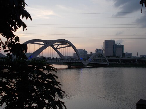
Figure 1. Hatirjheel Lake. Photograph by Shreyashi Dasgupta, 2016. CC BY 4.0.
In this essay, we examine how water, as a distinctive yet slippery feature of the urban landscape, relates to practices of “worlding” Dhaka city. “Worlding” refers to those aspirational, experimental, and speculative efforts that work to establish cities as part of global processes and imaginaries, such as that of the “world-class city” (Roy & Ong, Citation2011). While much has been written about the role that infrastructure plays in communicating global aspirations and visions for a world-class city (see Agbiboa, Citation2018; Anand, Citation2006; Graham, Citation2018; Harris, Citation2013; Manji, Citation2015), less attention has been paid to the way in which waterscapes permeate this “world-class aesthetics” (Ghertner, Citation2015). Moreover, when water is brought in explicit connection to the articulation of urban futures the emphasis is usually put on its management and governance, as is the case with high-modernist and technocratic imaginaries of the future (Randle & Barnes, Citation2018, p. 4). The aesthetic and affective qualities of water itself, and its capacity for shaping certain “spectatorial regimes” continue to be overlooked (Ray & Maddipati, Citation2020, p. 3). This is surprising, considering that waterbodies such as lakes and rivers play an increasingly important role in the “rebranding” of urban space (Gandy, Citation2014, p. 17).
We draw attention to this spectatorial dimension by asking how water helps to both create and destabilize urban views. By situating urban waterscapes as part of the broader context of the “worlding city” we seek to further unpack the latter as both a “site of emergence and a mass dream” (Roy & Ong, Citation2011, xvi). On the one hand, we are interested in how urban planning elites incorporate water into certain urban views and scenes – such as the imagery of Hatirjheel Lake – which are then morphed into mass dreams for the urban future. At the same time, it is not just these images of water that help to configure worlds and futures. Water itself also plays an important role in literally making world cities, in the sense that connections to elsewhere were long forged through rivers and seas (Anand, Citation2017, p. 28). Moreover, the fact that the presence of water is closely related to the edges of the city (Ashraf, Citation2017a), where urban horizons are continuously made and remade, also addresses attention to the emergence of the city itself and the way in which ordinary city dwellers are caught up in this speculative process. In more than just one way, water thus invites a focus on “the production of emergent spaces from the flows of ideas, actions, and objects” (Ong, Citation2011, p. 12).
Our aim in exploring how water helps to configure certain urban views and horizons is to confront some of the epistemological biases that have shaped our own ethnographic engagement with Bangladeshi urbanism. While each of us has conducted extensive fieldwork along the edges of Dhaka city – Annemiek on the cycle-rickshaw industry and Shreyashi on low-income housing – both of us have done so from a predominantly land-centric perspective.Footnote2 Each of us was conditioned, as Harms (Citation2015, p. 75) has nicely phrased it, “by the assumption (epistemic structure, if you wish), according to which the ground beneath one’s feet is simply there”. We take this essay as an opportunity to revisit some of our fieldwork experiences from a more amphibious perspective.
Moving away from land-centric urbanism
Urban landscapes in Bangladesh have been shaped significantly by the presence of water (Ahmed, Citation2017; Hafiz, Citation2007; Hossain, Citation2020a; Mowla, Citation2010). Ashraf (Citation2021) observes that “a terraqueous regime defines Bangladesh in which each and every town has a river running through it”. During British colonialism, however, this terraqueous regime was increasingly subjected to a “politics of forgetting” (Bhattacharyya, Citation2018, p. 5). This politics of forgetting worked to obscure the active nature of the Bengal delta, where meandering rivers and processes of erosion and sedimentation make it nearly impossible to “distinguish solid land from fluid waters” (Dewan, Citation2021, pp. 3–4). Still, colonial rule saw concerted spatial, legal, and discursive efforts to forcibly separate water from land (Bhattacharyya, Citation2018; Dewan, Citation2021; Hossain, Citation2020a; Iqbal, Citation2010; Saikia, Citation2019; Lahiri-Dutt & Samanta, Citation2013). Such attempts ran counter to the many ways in which people in Bengal had learned to live with water, as is reflected in local building and settlement patterns. To accommodate water and its excesses people relied on boats, portable homes, stilted houses, and homes with a “false roof” that enabled the storage of goods in times of excessive flooding (Shaw, Citation1992, p. 204). Such expressions of architecture are particularly widespread near rivers and on so-called charsFootnote3; (temporary) islands in the river that disappear and reemerge as rivers change their course.
Colonialism paved the way for forms of “dry planning” and land-centric urbanism that continue to be influential (Ashraf, Citation2017a; Hossain, Citation2020a; Mowla, Citation2010). Hossain (Citation2020a) describes how, since the British colonial period, “urban development involved confining the delta's constantly shifting waterways to create ‘dry’ land”. Similarly, Mowla (Citation2010) observes that whereas early urban settlement patterns allowed for ample water retention and centered around rivers and khals (canals) as important corridors of transport, this focus gradually shifted towards land and roads as European ideas about urban planning became more commonplace. This trend continued during the postcolonial period, with urbanization trajectories in Bangladesh being characterized by the encroachment and filling up of marshlands, ponds, and canals (Ahmed, Citation2017; Alam, Citation2018; Asad & Ahsan, Citation2012; Dasgupta, Citation2019; Hafiz, Citation2007; Hossain & Hackenbroch, Citation2019). The gradual transformation of Dhaka from a “city of channels” to a “city of concrete” (Asad & Ahsan, Citation2012, p. 293), and the concomitant disappearance of flood flow zones and waterbodies, has led to severe forms of waterlogging (Alam, Citation2018).
While land-centric forms of urban planning continue to be pervasive in Dhaka, this trend is increasingly critiqued by urban scholars and architects who stress the importance of understanding and accommodating water as a vital part of the urban landscape (Ashraf, Citation2017a; Ashraf, Citation2017b; Hossain, Citation2020a; Hossain, Citation2020b; Mowla, Citation2010; Peeters & Shannon, Citation2011). It is telling that water features prominently in a number of architecture projects that have won international awards, such as the “Friendship Hospital”; a hospital in rural Satkhira that harvests rainwater (Kashef Chowdhury/URBANA, Citation2013), “Khudi Bari”; a bamboo shelter on stilts that offers refuge to char dwellers in coastal Bangladesh (Marina Tabassum Architects, Citation2020), and the “Arcadia Education Project”; an amphibious school near Dhaka that floats during the monsoon (Saif Ul Haque Sthapati, Citation2015). While these projects express an aesthetics that reflects materials and structures, such as stilts and bamboo pavilions, that have long been part of the way in which ordinary people in Bangladesh inhabit the delta, they can also be viewed as experiments in the “art of being global” (Roy & Ong, Citation2011).
In many ways, this embrace of amphibious design represents a way of “telling new stories” about a country that has long been branded as a “basket-case” for cyclones, floods, and poverty (Hossain, Citation2021). By championing global trends towards resilient, water-centric, and flood-sensitive design (see Palazzo, Citation2019; Watson & Adams, Citation2010; Wong, Citation2006), Bangladesh is effectively positioning itself as a place from “where the future of the world is made” (Roy, Citation2011, p. 314).
Iconic views: waterscapes and scenes
While Dhaka’s water infrastructure – with its khals, nalas, pukurs and dobasFootnote4 – has long suffered and withered as a result of land-centric urbanism, water has never ceased to provide an attractive backdrop for recreational practices in the capital city. Already under British colonial rule, the Buriganga riverfront provided an important site for aesthetic interventions aimed at fostering a degree of resonance with other colonized cities (Mowla, Citation2016, p. 10). High-class residential buildings were built along the river, facing the waterfront, and the promenade was designed in such a way as to satisfy the sensibilities of European residents (Mowla, Citation2016, p. 10). These interventions expose a desire to capture and market water as part of a distinctly cosmopolitan urban view that alludes to urban scenes elsewhere. More than a century later, the Buriganga riverfront continues to inspire similar ambitions and imaginations, even as the river itself suffers from severe pollution. In an attempt to counter the deterioration and encroachment of the river, Dhaka South City Corporation (DSCC) pledged to restore the riverfront to its 1926 appeal, with “beautiful greenery, open space and recreation spots” (Badhon, Citation2020).
While conducting fieldwork on Dhaka’s cycle-rickshaw industry in 2017, Annemiek was confronted with some of the visioning exercises that foreshadowed this ambitious project. During a visit to Kamrangirchar, a peninsular neighborhood in the midst of the Buriganga river, she met with a local ward commissioner who was keen to disclose his ideas for redeveloping the embankment. Kamrangirchar had only recently started to urbanize and was mostly characterized by informal land uses, including a large number of cycle-rickshaw garages. To reach this char one had to cross a shallow and overgrown strand of the Buriganga river, which was filled almost entirely with garbage.Footnote5 The councilor, however, envisioned a much more world-class future for his ward. During an interview at his office he elaborated that, with the help of the government, he would be able to transform his neighborhood into a second Singapore, elaborating that the “Singapore river bank looks very planned and beautiful with different lights”. He also explained that the plan to refurbish the Buriganga waterfront had started with a visit of Prime Minister Sheikh Hasina to China: “She visited a city that was located at the bank of a river and thought of a plan for Dhaka. Our city is also situated at the bank of a river, so we can make it like a Chinese city”. His story thus highlights how water helps to constitute circuits of “inter-referencing” (Ong, Citation2011, p. 13), and is utilized to create an allusion to cities that are somehow considered emblematic of a generic allure of modernity.
Dhaka is not the only fast-growing city in the global South where aspirations for the future frequently draw on the imagery of foreign cities. In Mumbai political elites long to transform the city into “another Shanghai” (Anand, Citation2006, p. 3422; Prakash, Citation2008, p. 181), while urban authorities in the DRC have vowed to transform the city of Kinshasa into “the mirror of Africa” by emulating the urban landscape of Dubai (De Boeck, Citation2011). Indeed, visions for a world-class urban future are often “gleaned from refracted images and circulating models of other world-class cities” (Ghertner, Citation2011, p. 289). The example of the beautification of the Buriganga riverfront demonstrates how waterscapes are made part of such circulating models. Not only has the project been brought in connection with the Singapore riverbank; the river Thames is also frequently cited as an example of how the Buriganga riverside can be transformed into a nandonik poribes (“aesthetic environment”) (S. Shafique, Citation2021).
The ongoing preoccupations with the revitalization of the Buriganga waterfront foreground the tendency to treat water as part of a particular urban view, which in turn offers a window to other scenes and cities. The kind of mass dreams that such “magnificent views” elicit are not only shot through with images from elsewhere but also implicated in global flows of capital and processes of marketization that inevitably transcend locality. This becomes clear from the latest plans for the redevelopment of Kamrangirchar, which propose to transform this peripheral neighborhood into a “world-class business district” with an “iconic view” that is capable of attracting foreign investors (The Daily Star, Citation2021; The Finance Today, Citation2021). This plan epitomizes how the envisioned reconstruction of the Buriganga river serves as “a wider symbol for urban boosterism” (Gandy, Citation2014, p. 17). This tendency to reduce water to an “iconic view” ultimately results in a decentering of waterscapes, as it makes the river a mere accessory to processes of land speculation.
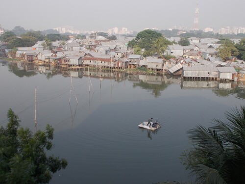
Shreyashi witnessed a similar dynamic unfold when looking for housing in Dhaka during her fieldwork. The balcony of her shared rental apartment in the Gulshan area, which is well known for its expensive real estate and upper-class allure, provided a “view” of the Gulshan-Banani Lake and had also been marketed as such. During the house viewing, the owner mentioned that these lake-facing apartments were high in demand due to their “premium view”. Shreyashi ended up sharing this “lake view” with some of the inhabitants of Korail bosti, one of the largest informal settlements in Dhaka. Despite long-lingering fears of eviction, stemming from its close proximity to high-value plots of land, Korail represents a robust and durable part of Dhaka’s urban landscape and is home to bustling markets, numerous pharmaceutical shops, small NGO schools and clinics, lively tea stalls, and a great variety of houses – ranging from solid two-story buildings to more tentative structures. Some of the most precarious dwellings can be found closest to the water, where people have used stilts to build makeshift houses over the lake () (see also T. Shafique, Citation2021). Rather than simply offering a view of the water, these houses are constantly destabilized by its presence. The makeshift bamboo piers and floorboards that support these clusters of stilted houses have to be replaced often, due to the damps and fumes rising up from the lake and the garbage that piles up along its edges. Living at one of these lakeside houses, therefore, means having to constantly navigate the risk of collapse and flooding, as well as the frightful possibility of kids falling into the water.
Figure 2. People crossing the Gulshan-Banani Lake by raft. Photograph by Shreyashi Dasgupta, 2016. CC BY 4.0.
Water thus only manifests itself as a “view” for those who can engage with it from a “dry perspective”. For people who actually have to navigate its flows, damps, excesses, and undercurrents water constitutes a much more uncertain and wobbly horizon. This element of instability, which is inherent to wet and watery landscapes, offers a useful point of departure for understanding worlding as a practice that, although always oriented towards certain views and imageries, is also “inherently unstable” (Roy, Citation2011, p. 313). Practices of worlding are aimed at horizons of aspiration that might or might not materialize and are, therefore, characterized by continuously shifting referents and vantage points.
Wobbly horizons and emerging edges
The stark contrast between the high rises that tower over the Gulshan-Banani Lake, and the improvised houses that are balancing on its perimeters, literally suspended in between land and water, exposes the tension between the representational and material qualities of water. The notion of the “worlding city” similarly oscillates between these two dimensions in the sense that it tries to combine a sensitivity to the aesthetic qualities of certain urban scenes with a focus on concrete practices and processes that (re)produce the city as a “site of emergence” (Roy & Ong, Citation2011, p. xvi). Water offers a helpful entry point into this examination of speculative processes of urban emergence. This is not just because water often literally flows at the nexus between what has already been established and what is still materializing, but also because it allows us to question the stability of such “sites of emergence”.
This element of instability does not just become apparent from the example of the stilt houses next to Banani Lake, but also from the way in which the residents of Korail navigate the lake itself. In fact, Shreyashi’s view every morning was that of makeshift rafts, stuffed with plastic bottles and cork sheets, ferrying three to four people (). Some rafts had cardboard or small wooden planks for people to sit or stand on. On some days, the wobbly raft capsized and people had to swim towards the land. Prior to the raft system, several boats had operated on the lake that ferried garment workers, school children, day labourers, security guards, and domestic workers to the upscale neighborhoods on the other side (Khan, Citation2017). In 2016, the government stopped the boat service, as part of a wider trend toward securitization in the area.Footnote6 During this ban, some locals started to use makeshift rafts to commute to work. In 2017, when asked whether boats would be allowed again in the future, a local ward commissioner explained that “there will be beautification of the lake and roads will be built alongside it and speedboats will run on the lake like Hatirjheel. So there is no scope for plying of these boats” (Khan, Citation2017). This example shows that the aestheticization of waterbodies can easily lead to forms of “ecological gentrification” (Gandy, Citation2014, p. 17) and poses a threat to those who tentatively inhabit the low-lying, peripheral urban areas where land and water merge.
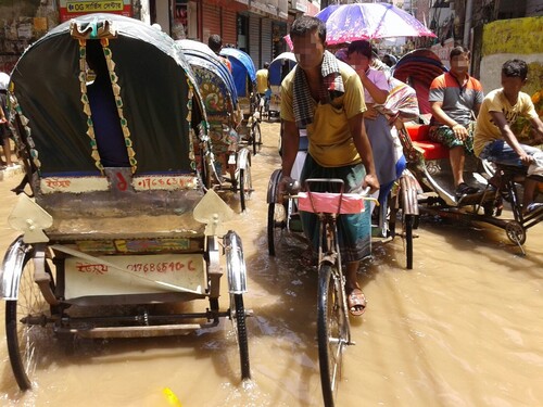
The remarks of the ward commissioner also provide an example of the way in which urban planning elites, in their efforts to envision alternative urban futures, try to fix and stabilize certain views and vantage points. The navigational practices of the residents of Korail, on the other hand, allude to aspirations of work and connectivity that require people to immerse themselves in a landscape that is inherently wobbly. This is also true for cycle-rickshaw drivers, who frequently have to navigate the presence of water during their journeys. During days of excessive rain and waterlogging, cycle-rickshaw drivers often operate their vehicles through flooded streets of water (). While passengers are semi-protected from the rain by the hood of the rickshaw and the plastic sheeting that is used to shield its interior, rickshaw drivers sometimes have to wade through the water with their lungis pulled up to their thighs. Although operating a rickshaw through the rain can be lucrative, as passengers are expected to pay a higher fare, it also involves the tricky exercise of circumventing patches of broken pavement and potholes that are invisible under the water. Annemiek experienced the inherent wobbliness of this exercise firsthand, when falling into the water from the passenger seat of the rickshaw after some invisible obstacle had caused the vehicle to tilt.
Figure 3. Rickshaws navigating the flooded streets of Dhaka (faces blurred to prevent identification). Photograph by Annemiek Prins, 2017. CC BY 4.0.
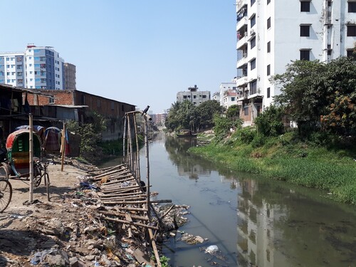
The rainy season thus signals a time when water forcefully reinserts its presence into Dhaka’s urban landscape, reminding people that the city is built “on liquid matter” (Ashraf, Citation2017a). During the monsoon, it becomes clear that water cannot be simply contained or captured as part of an attractive view, but always finds moments and places to surface. It is no coincidence that this happens mostly in peripheral and marginal areas, where water logging is most severe, considering that the more expensive and established parts of Dhaka have all been built on higher grounds (Kabir & Parolin, Citation2012, p. 12). Low-income housing, and informal land uses such as rickshaw garages (), on the other hand, are usually found near the fringes of city “along water bodies, flood plains, or low-lying land prone to regular inundation” (Hafiz, Citation2007, p. 61). This is also where urban newcomers and seasonal migrants, including rickshaw drivers, find a tentative place to stay in the city. Their aspirations of finding income and work in Dhaka, and their pursuits of alternative futures, are therefore very much premised on a willingness to negotiate the (nearness of) water and its excesses.
Figure 4. Rickshaws parked next to a drainage canal. Photograph by Annemiek Prins, 2022. CC BY 4.0.
The presence of water in Dhaka thus also gestures to the edges of certain processes of urbanization. In many ways, these edges constitute “sites of emergence” where flows and materials are transformed and “made into property” (Bhattacharyya, Citation2018, p. 4). On the one hand, such processes might solidify into dry patches of land, as waterbodies are filled in with debris and gradually transformed into high-rise buildings. On the other hand, the edge of the city is also where water reminds us that the worlding and making of cities is not only premised on the circulation of global images and flows of capital, but also intersects with non-human forms of movement. While those living in high-rise apartments might convince themselvesFootnote7 that these wobbly horizons are actually static views, for others balancing the ever-shifting boundary between land and water is central to their efforts of connecting to the city.
Conclusion
In this essay, we have advocated for a perspective on the “worlding city” that transcends stubborn notions of land-centric urbanism. This attempt to understand and situate worlding practices as part of living landscapes that are animated by water takes on added meaning in light of the ongoing climate crisis. In the specific context of Bangladesh, urbanists and architects are increasingly highlighting the need to remember and account for the truths of the Bengal delta, with its fluid boundaries between land and water, and to break with the forms of “dry planning” that were introduced during colonial times (Ashraf, Citation2017a; Hossain, Citation2020a; Mowla, Citation2010). This is also reflected in the number of prize-winning architecture projects that are firmly putting Bangladesh on the map when it comes to watercentric design.
Inspired by these trends in Bangladeshi architecture, we have tried to foreground the waterscapes of Dhaka, not as an object of developmentalist interventions, but as an explicit site of urban theory formation that can enrich and deepen discussions on the worlding city. At the same time, our work also shows that practices of worlding – despite their potential for putting certain places on the global map – are not inherently counterhegemonic or subversive. Worlding is also often about “finding a home in the order of global capital” (Roy, Citation2011, p. 323). This becomes clear from the “beautification” of waterbodies in Dhaka, which is very much about harnessing, projecting, and commodifying certain “iconic views” that can then, paradoxically, be made an accessory to processes of land speculation and gentrification.
At the same time, a focus on waterscapes has also allowed us to appreciate worlding as a practice that, although always oriented towards certain views, is “inherently unstable” (Roy, Citation2011, p. 313). Far from originating from a static vantage point, mass dreams for the urban future are entangled with processes of material change and emergence. In Dhaka, water serves as a poignant reminder of the fact that the cityscape is ultimately built on liquid matter. This element of wobbliness becomes particularly clear from the improvisational practices of those who constantly have to navigate the nearness of water in their pursuits to connect with the city and its opportunities. Often literally flowing at the nexus of what has already been established and what is still emerging, water thus opens up new ways of thinking about the processual making of the city and its shifting edges.
Authorship contribution
Both authors contributed equally to the research, design, and writing of this paper.
Declaration of conflicting interests
The author(s) declared no potential conflicts of interest with respect to the research, authorship, and/or publication of this article.
Disclosure statement
No potential conflict of interest was reported by the author(s).
Additional information
Funding
Notes
1 Over the past decade the Economist Intelligence Unit (EIU) has consistently classified Bangladesh’s capital Dhaka as one of the four “least liveable cities in the world”.
2 Annemiek carried out seventeen months of fieldwork in Dhaka between 2013 and 2018. Her research focused respectively on dwelling experiences in Korail bosti (informal settlement) and on the mobilities and labour trajectories of cycle-rickshaw drivers. Shreyashi conducted six months of field research in Dhaka between 2016 and 2018, focusing predominantly on mess accommodations (dormitories) for low-income workers in Mirpur and Rayerbazar.
3 There is a rich body of ethnographic and historical literature that focuses on the way in which riverine and char communities in rural Bangladesh navigate the ever-shifting boundary between land and water and the kind of building and dwelling practices this inspires (Dewan, Citation2021; Hossain, Citation2018; Iqbal, Citation2010; Khan, Citation2016; Shaw, Citation1992; Sultana, Citation2010; Zaman, Citation1988).
4 Khals are canals, nalas are shallow channels, pukurs are ponds, and dobas are small ponds. For an elaborate overview of the great variety of words used in Bengali to signal different types of water and waterbodies see Hanchett et al. (Citation2014, pp. 347–358).
5 According to recent reporting by bdnews24.com (Citation2022) this channel is now in the process of being cleaned and excavated, in an attempt to restore the old course of the River Buriganga.
6 In the aftermath of a deadly terrorist attack at a high-end restaurant in the so-called “diplomatic zone” – consisting of the neighborhoods Gulshan, Banani, and Baridhara – a number of security checkpoints was implemented at the entry points leading to this affluent part of Dhaka. This coincided with a reconfiguration of the local transport system, as rickshaw-, bus-, and boat services were (temporarily) curtailed or cut off altogether.
7 Geological experts in Bangladesh have warned that apartments that are built on marshy lands or filled-up wetlands might collapse, tilt or topple when monsoon rains create an “‘upward water pressure’ amid a falling groundwater level” (Roy, Citation2010). Even high-rises thus only offer the allusion of a stable view.
Bibliography
- Agbiboa, D. E. (2018). Conflict analysis in ‘world class’ cities: Urban renewal, informal transport workers, and legal disputes in lagos. Urban Forum, 29(1), 1–18. https://doi.org/10.1007/s12132-017-9312-5
- Ahmed, F. (2017). To flow or to fortify? Water, development and urbanism in building a deltaic metropolis [Unpublished doctoral dissertation]. University of Adelaide.
- Alam, M. J. (2018). Rapid urbanization and changing land values in mega cities: Implications for housing development projects in Dhaka. Bangladesh. Bandung, 5(1), 1–19. https://doi.org/10.1186/s40728-018-0046-0
- Anand, N. (2006). Disconnecting experience: Making world-class roads in Mumbai. Economic and Political Weekly, 41(31), 3422–3429. http://www.jstor.org/stable/4418535
- Anand, N. (2017). Hydraulic city: Water and the infrastructures of citizenship in Mumbai. Duke University Press.
- Asad, R., & Ahsan, R. (2012). Structuring urban sustainability with water: A case of Kamrangir Chor, Dhaka, Bangladesh. Journal of Social and Development Sciences, 3(8), 293–303. https://doi.org/10.22610/jsds.v3i8.713
- Ashraf, K. K. (2017a, November). Dhaka needs a hydraulic vision. The Daily Star. https://www.thedailystar.net/op-ed/dhaka-needs-hydraulic-vision-1443736
- Ashraf, K. K. (2017b, October). আগামীর ঢাকা. Kazi Khaleed Ashraf WRITINGS. https://kaziashraf.com/writings/bangla-essays/writingbangla-2/
- Ashraf, K. K. (2021, February). Future cities: A short guide to a Bengali urbanism. The Daily Star. https://online.thedailystar.net/supplements/30th-anniversary-supplements/aspirations-the-next-50-years/news/future-cities-short-guide-bengali-urbanism-2047517
- Badhon, H. M. (2020, November). Buriganga to get back 1926 look. Bangladesh Post.https://bangladeshpost.net/posts/buriganga-to-get-back-1926-look-47448
- Bdnews24.com. (2022, November). Restoration of a Buriganga channel. Bdnews24.com. https://bdnews24.com/media-en/image/lyzr5udh31
- Bhattacharyya, D. (2018). Empire and ecology in the Bengal delta: The making of Calcutta. Cambridge University Press.
- Chakrabarty, D. (1996). Remembered villages: Representation of Hindu-Bengali memories in the aftermath of the Partition. Economic and Political Weekly, 31(32), 2143–2151. http://www.jstor.org/stable/4404497
- Dasgupta, R. (2019). On the edge of Dhaka: The agrarian urbanization of south Asia. Anvesak, 49(1-2), 287–302.
- De Boeck, F. (2011). Inhabiting ocular ground: Kinshasa's future in the light of Congo's spectral urban politics. Cultural Anthropology, 26(2), 263–286. https://doi.org/10.1111/j.1548-1360.2011.01099.x
- Dewan, C. (2021). Misreading the Bengal delta: Climate change, development, and livelihoods in coastal Bangladesh. University of Washington Press.
- Gandy, M. (2014). The fabric of space: Water, modernity, and the urban imagination. MIT Press.
- Ghertner, D. A. (2011). Rule by aesthetics: World-class city making in Delhi. In In A. Roy, & A. Ong (Eds.), Worlding cities: Asian experiments and the art of being global (pp. 279–306). Wiley-Blackwell.
- Ghertner, D. A. (2015). Rule by aesthetics: World-class city making in Delhi. Oxford University Press.
- Graham, S. (2018). Elite avenues: Flyovers, freeways and the politics of urban mobility. City, 22(4), 527–550. https://doi.org/10.1080/13604813.2017.1412190
- Hafiz, R. (2007). The urban frontiers of Dhaka: Creating space above the water. In S. Jahan, & K. Maniruzzaman (Eds.), Urbanization in Bangladesh: Patterns, issues and approaches to planning (pp. 55–67). Bangladesh Institute of Planners.
- Hanchett, S., Monju, T. H., Akhter, K. R., Akhter, S., & Islam, A. (2014). Water culture in south Asia: Bangladesh perspectives. Development Resources Press.
- Harms, A. (2015). Leaving Lohāchāra: On circuits of emplacement and displacement in the Ganges delta. Global Environment, 8(1), 62–85. https://doi.org/10.3197/ge.2015.080104
- Harris, A. (2013). Concrete geographies: Assembling global mumbai through transport infrastructure. City, 17(3), 343–360. https://doi.org/10.1080/13604813.2013.798884
- Hossain, L. (2020a, August). Decolonising the cities to address flood, rain and water. The Daily Star. https://www.thedailystar.net/in-focus/news/decolonising-the-cities-address-flood-rain-and-water-1946013
- Hossain, L. (2020b, November). পানির আধুনিকায়ন, বন্যা ও শহর ভাবনার সংকট. Sarbojon Kotha. https://sarbojonkotha.info/sk-25-water-modernization-crisis/
- Hossain, M. A. (2018). Between uncertainty and hope: Disaster, displacement, and livelihoods on onishchit char in Bangladesh [Unpublished doctoral dissertation]. National University of Ireland.
- Hossain, N. (2021, December). Nobody is interested in Bangladesh. Himal South Asian. https://www.himalmag.com/nobody-is-interested-in-bangladesh-naomi-hossain-2021/
- Hossain, S., & Hackenbroch, K. (2019). Whose interest finally counts? The statutory production of urban space at the fringes of Dhaka. Bangladesh. Planning Theory, 18(2), 167–190. https://doi.org/10.1177/1473095218799804
- Iqbal, I. (2010). The Bengal delta: Ecology, state and social change, 1840–943. Palgrave Macmillan.
- Jasimuddin. (1951). Folk music of east Pakistan. Journal of the International Folk Music Council, 3, 41–44. https://doi.org/10.2307/835771
- Kabir, A., & Parolin, B. (2012). Planning and development of Dhaka – A story of 400 years [paper presentation]. 15th international planning history society conference, São Paulo, Brazil.
- Kashef Chowdhury/URBANA. (2013). Friendship Hospital Satkhira [Architectural design]. Kashef Chowdhury/URBANA, Dhaka, Bangladesh. https://www.architecture.com/awards-and-competitions-landing-page/awards/riba-international-awards/2021/friendship-hospital-satkhira
- Khan, M. R. (2017, January). Boatmen struggling to navigate thru life. The Daily Star. https://www.thedailystar.net/city/boatmen-struggling-navigate-thru-life-1345495
- Khan, N. (2016). Living paradox in riverine Bangladesh: Whiteheadian perspectives on Ganga Devi and Khwaja Khijir. Anthropologica, 58(2), 179–92. https://www.jstor.org/stable/26350479 https://doi.org/10.3138/anth.582.T02
- Lahiri-Dutt, K., & Samanta, G. (2013). Dancing with the river. Yale University Press.
- Manji, A. (2015). Bulldozers, homes and highways: Nairobi and the right to the city. Review of African Political Economy, 42(144), 206–224. https://doi.org/10.1080/03056244.2014.988698
- Marina Tabassum Architects (MTA. (2020). Khudi Bari [Architectural design]. Marina Tabassum Architects (MTA), Dhaka, Bangladesh. https://marinatabassumarchitects.com/khudi-bari/
- Mookherjee, N. (2006). Muktir gaan (song of freedom), the raped woman and the migrant identities of the Bangladesh war. In N. C. Behera (Ed.), Gender, conflict and migration (pp. 72–96). Sage.
- Mowla, Q. A. (2010). Role of water bodies in Dhaka for sustainable urban design. Jahangirnagar Planning Review, 8, 13–30.
- Mowla, Q. A. (2016). Colonial spatial planning versus local tradition in the morphology of urban Dhaka. In M. Rahman (Ed.), Dhaka: An urban reader (pp. 1–28). University Press Limited.
- Ong, A. (2011). Introduction: Worlding cities, or the art of being global. In A. Roy, & A. Ong (Eds.), Worlding cities: Asian experiments and the art of being global (pp. 1–26). Wiley-Blackwell.
- Palazzo, E. (2019). From water sensitive to floodable: Defining adaptive urban design for water resilient cities. Journal of Urban Design, 24(1), 137–157. https://doi.org/10.1080/13574809.2018.1511972
- Peeters, S., & Shannon, K. (2011). Readdressing Dhaka’s public water bodies: A design research. Nakhara: Journal of Environmental Design and Planning, 7, 25–46.
- Prakash, G. (2008). Mumbai: The modern city in ruins. In A. Huyssen (Ed.), Other cities, other worlds: Urban imaginaries in a globalizing age (pp. 181–206). Duke University Press.
- Preetha, S. S. (2013, January). Beautified Hatirjheel attracts visitors. The Daily Star. https://www.thedailystar.net/news-detail-264600
- Randle, S., & Barnes, J. (2018). Liquid futures: Water management systems and anticipated environments. WIRES Water, 5(2), e1274. https://doi.org/10.1002/wat2.1274
- Ray, S., & Maddipati, V. (2020). Water histories of south Asia: The materiality of liquescence. Routledge.
- Roy, A. (2011). Conclusion - postcolonial urbanism: Speed, hysteria, mass dreams. In A. Roy, & A. Ong (Eds.), Worlding cities: Asian experiments and the art of being global (pp. 307–335). Wiley- Blackwell.
- Roy, A., & Ong, A. (2011). Worlding cities: Asian experiments and the art of being global. Wiley-Blackwell.
- Roy, P. (2010, June). Filled-up, full of risk. The Daily Star. https://www.thedailystar.net/news-detail-141744
- Saif Ul Haque Sthapati (SHS). (2015). Arcadia education project at Keraniganj, Dhaka [Architectural design]. Saif Ul Haque Sthapati (SHS), Dhaka, Bangladesh. https://the.akdn/en/how-we-work/our-agencies/aga-khan-trust-culture/akaa/arcadia-education-project
- Saikia, A. (2019). The unquiet river: A biography of the Brahmaputra. Oxford University Press.
- Shafique, S. (2021, November). বুড়িগঙ্গাকে ‘টেমস’ বানাতে মাস্টারপ্ল্যান. Bangla Tribune. https://www.banglatribune.com/others/711269/বুড়িগঙ্গাকে-‘টেমস’-বানাতে-মাস্টারপ্ল্যান
- Shafique, T. (2021). Re-thinking housing through assemblages: Lessons from a deleuzean visit to an informal settlement in Dhaka. Housing Studies, 37(6), 1–20. https://doi.org/10.1080/02673037.2021.1988065
- Shaw, R. (1992). ‘Nature’, ‘culture’ and disasters: Floods and gender in Bangladesh. In E. Croll, & D. Parkin (Eds.), Bush base, forest farm: Culture, environment, and development (pp. 200–217). Routledge.
- Sultana, F. (2010). Living in hazardous waterscapes: Gendered vulnerabilities and experiences of floods and disasters. Environmental Hazards, 9(1), 43–53. https://doi.org/10.3763/ehaz.2010.SI02
- The Daily Star. (2021, November). Kamrangirchar to have a world-class business district: Taposh. The Daily Star. https://www.thedailystar.net/news/bangladesh/governance/news/kamrangirchar-have-world-class-business-district-taposh-2223506
- The Finance Today. (2021, October). DSCC plans central business district in Kamrangirchar to woo global investors. The Finance Today. https://thefinancetoday.net/article/business/17047/DSCC-plans-central-business-district-in-Kamrangirchar-to-woo-global-investors
- Watson, D., & Adams, M. (2010). Design for flooding: Architecture, landscape, and urban design for resilience to climate change. John Wiley & Sons.
- Wong, T. H. (2006). Water sensitive urban design-the journey thus far. Australian Journal of Water Resources, 10(3), 213–222. https://doi.org/10.1080/13241583.2006.11465296
- Zaman, M. Q. (1988). The socioeconomic and political dynamics of adjustment to riverbank erosion hazard and population resettlement in the Brahmaputra-Jamuna floodplain [Unpublished doctoral dissertation]. University of Manitoba.
- Zeitlyn, B., Janeja, M. K., & Mapril, J. (2014). Introduction. Imagining Bangladesh: Contested Narratives. South Asia Multidisciplinary Academic Journal, 9, 1–16. https://doi.org/10.4000/samaj.3739